Mexico’s population: now over 117 million and expected to peak at about 138 million

 Updates to Geo-Mexico  Comments Off on Mexico’s population: now over 117 million and expected to peak at about 138 million
Feb 282013
 

Mexico’s population in January 2013 was 117.4 million; 57.3 million males (48.8%) and 60.1million (51.2%) females according to a December 10, 2012 report by CONAPO (Consejo Nacional de Población) in Proyecciones de la población de México 2010-2050”. By January 2014 it will grow by over a million to 118.6 million. However demographic trends indicate that population growth in Mexico is declining significantly.

The birth rate is expected to fall from 19.7 births per 1,000 population in 2010 to 14.0 in 2050. As the Mexican population ages the death rate is projected to increase from 5.6 per 1,000 in 2010 to 9.2 in 2050. Consequently the annual rate of natural population growth is expected to decline from 1.41% in 2010 to 0.48% in 2050. Extrapolating the trends from the CONAPO projection suggests that death rates will surpass birth rates sometime in the by 2070s and natural population change will become negative. Of course, we must also take emigration into account.

According to the CONAPO report net emigration from Mexico was 321,000 in 2012, though some have noted that due to the Great Recession net emigration to the USA is near zero or less [Pew Research Center’s “Net Migration from Mexico Falls to Zero – and Perhaps Less”]. CONAPO expects net emigration to peak at about 689,000 by 2020 and then gradually decline to 590,000 by 2050. Given the current low levels of emigration to the USA and the rapid growth of the Mexican economy, some feel that these levels are rather high.

As a result of trends in birth rates, death rates and emigration, Mexico’s population growth rate is declining. Annual population growth is expected to fall below a million in 2017, below 500,000 in 2032 and below 100,000 by 2049. Extrapolating the rates in the CONAPO projection, Mexico’s population growth is expected to peak in 2053 at 137.6 million and then start to gradually decline. Of course, it is very difficult to accurately project emigration figures. If emigration is a third less than projected by CONAPO, then Mexico’s population could peak at 145 million.

Related posts:


Paricutin Volcano in Mexico celebrates its 70th birthday

 Other  Comments Off on Paricutin Volcano in Mexico celebrates its 70th birthday
Feb 202013
 

Today (20 February 2013) marks the 70th anniversary of the first eruption of Paricutín Volcano in the state of Michoacán in western Mexico.

The landscape around the volcano, which suddenly started erupting in the middle of a farmer’s field in 1943 and which stopped equally abruptly in 1952, is some of the finest, most easily accessible volcanic scenery in the world. A short distance northwest of Uruapan, this is a geographic “must see”, even if you can only spare a few hours.
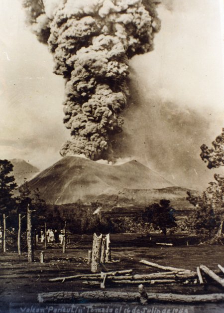
Paricutín Volcano, 16 July 1943

Paricutín Volcano, 16 July 1943

What makes Paricutín so special is that in all of recorded history, scientists have had the opportunity to study very few completely new volcanoes in continental areas (whereas new oceanic island volcanoes are comparatively common). The first two new volcanoes formed in the Americas in historic times are just one hundred kilometers apart. The first was Jorullo, which erupted in 1759, and the second is Paricutín.

Dominating the valley where Paricutín now exists is the peak of Tancítaro, the highest point in the state of Michoacán at 3845 meters (12,615 feet), and sometimes snow-capped in winter. In 1943, the local Purépechan Indians inhabited a series of small villages and towns spread across the valley floor. The villages included Angahuan, which still exists today, Paricutín, where all 500 people lost their homes, and San Juan Parangaricutiro. The latter was once famous for hand-woven bedspreads and quilts and consequently known as San Juan de las Colchas (bedspreads). Its church, begun in 1555, had never been finished and only ever had a single tower.

On 20 February 1943, a local campesino named Dionisio Pulido was tending his crops with his wife Paula, their son and a friend. At about 4:00pm, they noticed a small crack and felt the ground shaking under their feet. While they watched, the ground rose more than 2 meters and smoke rose into the air, accompanied by whistling noises and the smell of sulfur. Sparks set fire to a nearby pine tree. Not surprisingly, they fled!

Legend has it that Dionisio first tried to smother the emerging volcano with loose rocks and afterwards was of the opinion that the volcano would never have erupted if he hadn’t plowed his field, but such reports are almost certainly pure fiction.

The volcano grew rapidly, providing onlookers, visiting vulcanologists and residents alike, with spectacular fireworks displays. The month of March was a particularly noisy time in Paricutín’s history—explosions were heard as far away as Guanajuato and ash and sand were blown as far as Mexico City and Guadalajara.

After one week, the volcano was 140 meters high, and after six weeks 165 meters.

In April 1943 there were major lava flows, originating from about 10 kilometers underground. These lavas were basaltic; their chemistry suggested temperatures inside the volcano of between 960o and 1020oC. More than 30 million metric tons of lava flowed from the volcano between April and June 1943, raising the volcano’s height to more than 400 meters before its first birthday.

In early 1944, another lava flow streamed in a gigantic arc reaching the outskirts of the town of San Juan Parangaricutiro. Fortunately, the town had already been abandoned following many earthquakes, some of which rang church bells as far away as Morelia! The lava flowed about 30 meters a day and went right through the church but, miraculously, left the main altar standing. The parts of the church which survived in “old” San Juan, including its altar, can still be visited today, though reaching them involves clambering over jagged blocks of lava.

The villagers who had abandoned the town were escorted to Uruapan for safety. Some of them later founded a new town called San Juan Nuevo. Other villagers moved away to live in Los Reyes, Uruapan, Angahuan, Morelia and Guadalajara.

Yet another lava flow buried the village of Paricutin which fortunately had also been evacuated in time. Nothing remains of this village, covered by lava which is more than 200 meters thick in places! A small cross atop the lava marks its approximate position. Besides lava, ashes and dust were also thrown out by the volcano. The ash was 1 millimeter thick in Guadalajara, 25 centimeters thick in Angahuan, and 12 meters thick near the cone. The volcano rose 410 meters above the original ground surface.

Suddenly, in February 1952, nine years after the volcano first erupted, the lava stopped flowing. In many places, plumes of hot steam still rise as fumaroles from the ground, ground that is still most distinctly warm to the touch.

Enjoying a full day at Paricutín has been made much easier since the construction of rustic tourist cabins on the edge of Angahuan village. The restaurant, which serves tasty local specialties, gives clients a panoramic view encompassing the lava and the half-buried church. A small permanent exhibition of maps, charts and photographs in one of the cabins, describing the volcano’s history and the surrounding area, was inaugurated in February 1993 to commemorate the 50th anniversary of the volcano.

Horses can be hired for a trip to the church or to the more distant cone of the volcano. The latter requires an early start since the last part involves clambering up the loose ashes and cinders which comprise the cone and scrambling onto the narrow rim of the truly magnificent crater. A marvelous view can be enjoyed from atop the crater rim and only then can the full extent of the area devastated by the volcano be fully appreciated. Nothing can quite have prepared you for this startling lunar-like landscape.

Note:

This post is a lightly edited extract from my “Western Mexico: A Traveler’s Treasury” (Sombrero Books, 2013). Chapter 35 describes Paricutín Volcano and its surrounding area, including the fascinating indigenous village of Angahuan, in much more detail. “Western Mexico: A Traveler’s Treasury” is also available as either a Kindle edition or Kobo ebook.

Related posts:

The geography of Mexico’s drug trade: new cartels involved in turf wars

 Mexico's geography in the Press, Updates to Geo-Mexico  Comments Off on The geography of Mexico’s drug trade: new cartels involved in turf wars
Feb 202013
 

As we suggested a year ago – Mexico’s drug cartels and their shifting areas of operation, a 2012 update  – it is increasingly difficult to track the areas of operation of the major drug trafficking groups in Mexico. The U.S. Department of the Treasury’s Office of Foreign Assets Control recently added a new narcotrafficking group in Mexico, the Meza Flores family, to its list of Foreign Narcotics Kingpins. (This designation prohibits people in the USA from engaging in transactions with the named individuals or their organization, and freezes any assets the individuals or organization may have under U.S. jurisdiction).

According to the Treasury Department’s statement, the Meza Flores family began operations in about 2000 and is responsible for the distribution of considerable quantities of methamphetamines, heroin, cocaine and marijuana in the USA. It is headed by Fausto Isidro Meza Flores (aka “Chapito Isidro”) and is based in the town of Guasave, in the state of Sinaloa. (Meza Flores was previously in the Juárez cartel before becoming a high ranking member of the now defunct Beltran Leyva cartel).

The Meza Flores group is a direct rival of the long-established and very powerful Sinaloa cartel. The Sinaloa cartel is headed by Joaquín “El Chapo” Guzmán Loera, who has been on the run since escaping from the maximum security jail in Almoloya de Juárez, near Toluca, in 2001. According to Forbes Magazine, Guzman Loera is currently Mexico’s 10th richest individual, with assets of around one billion dollars.

Mexico’s “War on Drugs” in recent years has led to a fragmentation of the major cartels. Some experts claim that as many as 80 distinct groups are now involved in drug production and trafficking. Many of these groups are small and highly localized, but this fragmentation has increased the incidence of turf wars between rival groups. These turf wars have caused extreme levels of violence in some parts of the country. Once one side is firmly in control, the violence drops.

The current federal administration has said that some 70,000 people died in Mexico between 2006 and 2012 as a result of the activities of organized crime. Recent press reports such as Jalisco: La invasión de Los Templarios claim that one on-going boundary war is along the state boundary between Michoacán and Jalisco. This conflict is between the Michoacán-based Knights Templar (Los Caballeros Templarios, LCT) and the Jalisco-based New Generation cartel (CJNG).

The LCT is comprised largely of former members of  La Familia Michoacana (LFM), a group which is now almost defunct. Other members of LFM joined the Zetas, the Sinaloa cartel’s arch enemy. The CJNG started out as enforcers for the Sinaloa Cartel.

Violence linked to this particular turf war has occurred in numerous municipalities including Jilotlán de los Dolores, Pihuamo, Mazamitla, San José de Gracia, La Barca, Atotonilco, Ayotlán, Tizapán el Alto, Tuxcueca, Jocotepec and Chapala (all in Jalisco), as well as Briseñas, Yurécuaro, Sahuayo, Marcos Castellanos, La Piedad, Zamora, Cotija de La Paz, Tepalcatepec, Los Reyes, Peribán and Apatzingán (all in Michaocán).

This is not the only turf war currently underway in Mexico. For example, further north, another recent hot spot has erupted along the Durango-Coahuila border, especially in the La Laguna area centered on the city of Torreón.

Related posts:

The geography of the Huichol Indians: cultural change

 Other  Comments Off on The geography of the Huichol Indians: cultural change
Feb 182013
 

Huichol Indians may have retained many of their ancestral traditions, such as shamans and their annual cycle of ceremonies, but Huichol culture has changed significantly in the past three hundred years.

During colonial times, the Huichol adopted string instruments, the use of metal tools, and the keeping of animals such as sheep, horses and cattle. They also accepted some aspects of Catholic religion.

Beginning in the 1950s, government programs financed the first airstrips in the region. Government agencies have since improved roads, opened clinics and constructed schools for basic education and trades. The government’s efforts have included agricultural aid stations, the drilling of wells, and support for the introduction of more modern agricultural techniques and equipment, such as barbed wire and tractors. Other programs have focused on providing alternative sources of revenue such as beekeeping.

Modern adaptation: Huichol "vocho" exhibited at the Smithsonian in 2012

Modern adaptation: Huichol “vocho” exhibited at the Smithsonian in 2012

All these changes have come at a price. The ancestors of the Huichol practiced a nomadic lifestyle over a large expanse of land in order to acquire the resources they needed for survival. When the Huichol were pushed back into the mountains,they adapted by undertaking an annual migration to gather their sacred peyote. At the same time, they became increasingly dependent on the cultivation of corn. However, in such marginal areas where rainfall is unreliable the corn harvest is never guaranteed and in bad years starvation is a real possibility.

Closer links to the outside world have meant that the Huichol can now buy cheap, bottled alcohol, and face increased pressure from outsiders who want more grazing land, timber and minerals. They have also led to the out-migration of many Huichol, whether permanently to nearby cities or seasonally to work on tobacco plantations in Nayarit. In the past fifty years, this has led to some innovations in Huichol art, including the addition of large yarn paintings and larger items decorated with complex bead work (see image) to their traditional arts and crafts.

Even though the Huichol are one of the most isolated (not just geographically but also economically and socially) indigenous groups in Mexico, there is nothing static about their culture. It will be interesting to see what changes the future brings.

Related posts:

Bibliography:

This mini-series has made extensive use of several resources, including:

  • Barrin, Kathleed (ed) Art of the Huichol Indians. The Fine Arts Museums of San Francisco, 1978.
  • Mata Torres, Ramón. La Vida de los Huicholes. Tomo I. 1980. Guadalajara, Jalisco.
  • Mata Torres, Ramón. El Arte de los Huicholes. Tomo II. 1980. Guadalajara, Jalisco.
  • Neurath, Johannes. Pueblos Indígenas del México Contemporáneo: Huicholes. Comisión Nacional para el Desarrollo de los Pueblos Indígenas / UN Development Program. 2003. [link is a pdf download]

Which political party has the most state governors?

 Other, Updates to Geo-Mexico  Comments Off on Which political party has the most state governors?
Feb 162013
 

Mexican governors are elected for single six-year terms; re-election is not permitted by the Mexican Constitution. The terms of governors in different states overlap; for example, seven of the 32 governors began their term of office in 2012.

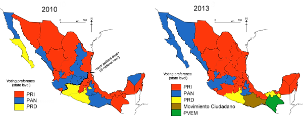
The PRI (Partido Revolucionario Institucional, Institutional Revolutionary Party) currently holds 19 of the 32 governorships spread throughout Mexico (states colored red on map), except for the northwest and extreme south. On 1 March 2013, PRI will gain another governorship when Aristoteles Sandoval of PRI replaces the current PAN Governor of Jalisco. Although PRI Presidential candidate, Enrique Peña Nieto, easily won the Mexican Presidency in 2012, of seven new governors inaugurated in 2012, only three were from PRI.

Ex-President Calderón’s PAN (Partido Acción Nacional, National Action Party) is a distant second with seven governorships (blue on map); six after 1 March 2013. Four of the PAN governorships are in the northwest.

The PRD (Partido de la Revolución Democrática, Party of the Democratic Revolution) is third with four governorships (yellow on map). Three of the PRD governors took office in 2012. PRD has held the important governorship of the Mexico City Federal District since 1988.

State governorships, 2010 and 2013

State governorships, 2010 and 2013

The Governor of Oaxaca (brown on 2013 map) is from the Movimiento Ciudadano (Citizens’ Movement, formerly known as Convergencia or Convergence), which supported López Obrador in the 2006 presidential election. The Governor of Chiapas is from the PVEM (Partido Verde Ecologísta de México; Mexico’s Green Party; green on the 2013 map).

The north-south political divide that we have referred to in some previous posts, including the equivalent map for 2010 shown above, is no longer evident in the current pattern of state governorships.

Related posts:

The crater lake of Santa María del Oro yields evidence for climate change

 Books and resources  Comments Off on The crater lake of Santa María del Oro yields evidence for climate change
Feb 142013
 

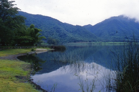
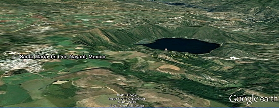
A magnificent crater lake nestles in a centuries-old volcanic crater a short distance east of the town of Santa María del Oro in Nayarit.

The connecting road from Highway 15 first passes through the former mining town of Santa María del Oro and then rises slightly to offer a splendid view of the beautiful slate-blue lake (known locally as “La Laguna”), set in a ring of verdant hills. In recent years, the lake, a good example of a geomorphosite, has become important for tourism with accommodations ranging from RV spaces to a boutique hotel. It takes about an hour and a half to stroll round the track that encircles the crater lake. Other attractions include visiting an abandoned gold mine (which offers a glimpse into the area’s past), birding, mountain biking, swimming or hiring a rowboat or kayak to venture out onto the lake.

Crater Lake, Santa María del Oro. Credit: Tony Burton

Crater Lake, Santa María del Oro. Credit: Tony Burton

This usually quiet lake has proved to be a valuable source of information for geologists and climatologists investigating the history of climate change in this region of Mexico.

The researchers who published their findings in 2010 in the Bulletin of the Mexican Geological Society extracted a sediment core from the deepest part of the lake. The relatively small area of the drainage basin surrounding the lake and the relatively steep slopes of surrounding hills mean that the sediments entering the lake are rarely disturbed after they are deposited. Wind and wave action are limited. The depth of the lake (maximum 65.5 meters) also helps to ensure that sediments remain undisturbed for centuries. This gives perfect conditions for a reliable sediment core.

Santa María del Oro. Credit: Google Earth

Santa María del Oro. Credit: Google Earth

The team analyzed the titanium, calcium and magnetism levels of successive thin slices of the core. By comparing the core with historic records and previous tree ring analyses from the same general area, they were able to accurately date each slice. The titanium levels in each slice allowed the researchers to quantify how much runoff occurred in that year, a proxy indicator of precipitation.

The team identified 21 significant drought events over a period of 700 years. The six most marked droughts occurred in 1365–1384, 1526, 1655-1670, 1818, 1900 and 1930-2000. They found periodicities of 25, 39, 50, 70 and 117 years for drought events, meaning that droughts occurred at fairly regular intervals of about 20-25 years.

The researchers then looked at the possible correlation between periods of drought and two distinct climatological factors: a shift to the south in the position of the Inter Tropical Convergence Zone (ITCZ) in summer and the occurrence of El Niño Southern Oscillation (ENSO) events. When the ITCZ does not extend as far north as usual during Mexico’s summer rainy season, states such as Nayarit and Jalisco receive less than their normal amount of rainfall. During ENSO events, rainfall is also diminished in central and western Mexico.

Of the 21 droughts identified and studied, 7 proved to be statistically linked to ENSO events, 10 to ITCZ movements, and the remaining 4 events were closely linked to a combination of both.

As the study concludes, titanium analysis of sediments may allow for a more refined record of climate change in the period prior to reliable historic or instrumental records which might improve the understanding of how and why climate change occurred in past

Santa María del Oro is also worth visiting because it is only a short distance away from the edge of the canyon of the River Santiago and the El Cajón hydro-electric power project, one of three major HEP projects located along that river.

Source article:

Susana Sosa-Nájera, Socorro Lozano-Garcí, Priyadarsi D. Roy and Margarita Caballero. Registro de sequías históricas en el occidente de México con base en el análisis elemntal de sedimentos lacustres: El caso del lago de Santa María del Oro. Boletín de la Sociedad Geológica Mexicana, Vol 62, #3, 2010, p 437-451.

Santa María del Oro and surrounding areas are described in chapter 24 of the recently published 4th (Kindle/Kobo) edition of my Western Mexico: A Traveler’s Treasury (Sombrero Books, 2013).

Related articles:

Ecological footprints, marine conservation and Cancun’s underwater sculpture park

 Mexico's geography in the Press  Comments Off on Ecological footprints, marine conservation and Cancun’s underwater sculpture park
Feb 112013
 

The Global Ocean Commission, a new, high-level international effort to try to stave off eco-disaster in the world’s oceans, is being launched tomorrow in London, U.K.. Headed by former UK foreign secretary, David Miliband, former South African finance minister Trevor Manuel, and José María Figueres, a former president of Costa Rica, the Commission will promote international efforts to ensure the effective governance of international waters, and agreements governing such activities as deep sea fishing, pirate fishing, sea-floor mining and geo-engineering, all considered to be potential threats to the long-term viability of ocean ecosystems.

Miliband is quoted as saying that “We are living as if there are three or four planets instead of one, and you can’t get away with that.” Actually, the ecological footprint of the USA, as one example, is much closer to ten “global hectares per person” than three or four. (Each global hectare encompasses the average annual productivity of all biologically productive land and ocean areas in the world). The world’s biocapacity—the amount of resources its ecosystems can supply each year—is only equivalent to about 2 global hectares per person, a value that is declining each year as population increases (see Mexico’s ecological footprint compared to that of other countries).

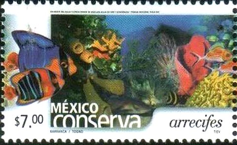
2002 Postage Stamp: reef conservation

2002 Postage Stamp: reef conservation

Mexico is one of the six most biodiverse countries in the world. While it has taken many steps to protect its marine resources, by enacting legistlaiton establishing fishing restrictions and protected areas, much remains to be done. Mexico’s coral reefs are particularly vulnerable. For example, the Cancún Marine Park is one of the most visited stretches of water in the world with over 750,000 visitors each year, placing immense pressure on its resources. We described one unusual conservation effort related to this area in “Artificial reef near Cancún doubles as an underwater art gallery” [Mar 2012] which looked at the work of Artist Jason deCaires Taylor, who created an underwater sculpture park, the Underwater Art Museum (Museo Subaquatico de Arte, MUSA), near Cancún.

The museum, begun in 2009, currently consists of more than 450 permanent life-size sculptures set in the waters surrounding Cancún, Isla Mujeres and Punta Nizuc. Taylor is adding sixty additional underwater sculptures to the park, many of them modeled after local residents. This underwater museum is both attractive and functional, providing new habitat for coral and other marine life, as well as diverting snorkelers and divers away from fragile coral reefs, allowing them more chance to recover from the impacts of overuse.

The cultural geography of Mexico’s carnival celebrations

 Other  Comments Off on The cultural geography of Mexico’s carnival celebrations
Feb 092013
 

Carnival celebrations are underway in many Mexican towns. Carnival (carnaval) is a time for merry-making in the days prior to Ash Wednesday, the beginning of Lent in the Christian liturgical calendar. (In 2013, Ash Wednesday falls on 13 February.) Carnival originated in Italy and was introduced into Mexico several centuries ago by the Spaniards. Even though the proportion of Mexico’s population that is Catholic has fallen steadily in recent decades – see Religious diversity is increasing in Mexico – the popularity of carnival shows no signs of decline.

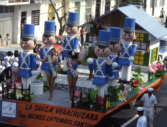
Carnival float, Veracruz

Carnival float, Veracruz

According to Wikipedia, more than 220 towns in Mexico celebrate Carnival. Frances Toor, an authority on Mexican folklore, claims that carnival festivities in Mexico City “reached their climax about the middle of the nineteenth century and have died out since the 1910–1920 Revolution.” Very few large cities in Mexico have important carnival celebrations, the most notable exceptions being Veracruz, Mérida and Mazatlán.

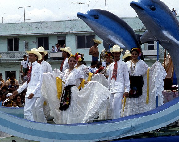
Carnival float, Veracruz

Carnival float, Veracruz

By far the most interesting carnival celebrations in Mexico are those held in smaller towns and villages in non-tourist areas. In this regard, the carnival in Huejotzingo, in the state of Puebla, stands out. It is aptly labeled by Toor in “A Treasury of Mexican Folkways”, published in 1947, as “the most elaborate and brilliant of the village carnivals”. Toor describes this carnival in considerable detail, saying that it “dramatizes the capture and death of Agustín Lorenzo, a famous bandit, who with his men used to rob convoys between Mexico City and Vera Cruz and then hide in the near-by gorges or mountains. According to the carnival plot, he ran off with the beautiful young daughter of a rich hacendado, took her to one of his hideouts and was having a wedding celebration when the federal soldiers fell upon them.”

In Toor’s time, about 1000 villagers participated each year, dressed as soldiers in elaborate costumes representing several different battalions. She notes that “In recent years [1940s] some new features have been added to the Huejotzingo carnival. At dawn, all the forces fight against the French, who occupy the plaza, which is besieged and taken. The bride is said to be the beautiful daughter of the French Emperor Maximilian, instead of a rich hacendado”. Today, more than 2000 villagers take part. Most modern descriptions of the carnival in Huejotzingo describe it is an intermixing of three separate plots: the Battle of Puebla (where Mexican forces defeated the French on 5 May 1842), the kidnapping of the mayor’s daughter, and the first Christian marriage in Mexico.

Other places with idiosyncratic carnival celebrations include Huixquilucan (State of México), Calnali (Hidalgo), Tlayacapan (Morelos), Tuxpan de Bolaños (Jalisco), San Juan Chamula and Chenalho (both in Chiapas) and Zaachila (Oaxaca).

This Youtube video clip shows 2012 carnival revelry in Cozumel:

As with almost every aspect of Mexico’s cultural geography, there is no one fixed or rigid “tradition”. Instead, there have been so many significant changes over time that today’s celebrations of carnival across Mexico are characterized as much by their distinctive regional variations as by their similarity.

Related post:

The geography of the Huichol Indians: economy, lifestyles and settlements

 Other  Comments Off on The geography of the Huichol Indians: economy, lifestyles and settlements
Feb 072013
 

In this post we take a closer look at the traditional life and settlement patterns of the Huichol Indians.

The origins of the Huichol are unclear. The Wixárika themselves believe they arrived in the Jalisco-Nayarit area from the Valley of the Mexico, though most anthropologists believe it is more likely that they came originally either from the north or from the Nayarit coast.

Huichol economy and lifestyle

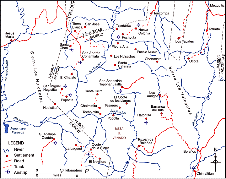
In the Huichol heartland area (shown on the map) the rainy season normally begins in June and lasts until October, a similar timing to most of central and western Mexico. While average temperatures in the area are usually between 15 and 20 degrees Centigrade, there can be sharp frosts in winter.

huichol-villages

The dispersed rural settlement pattern of the Huichol heartland. Credit: Tony Burton / Geo-Mexico; all rights reserved

Huichol family groups rely on the subsistence farming of corn, beans and squash, which are grown together in a small plot or garden (coamil). Tomatoes, chiles and gourds are also produced, Cultivation is often on steep slopes. Land is cleared by slash and burn. A few cattle may be kept, largely because of their value as trade items. Meat is rarely available except on ceremonial occasions. Some fishing is practiced, and wild plants also form part of the typical Huichol diet. Merchants supply other items such as salt, shells, feathers, canned drinks and sandals.

The typical Huichol home is a simple, one-room dwelling, usually rectangular in plan, with a thatched roof. Some homes have a second room for cooking.

The isolation of the Huichol has enabled them to retain almost all of their traditional customs. Anthropologists who have lived among the Huichol affirm that religion for the Huichol is not part of life, it is life.

Three of the most important symbols for the Huichol are deer, corn (maize) and peyote. In some ways, these three items underline the fact that the Huichol culture has undergone a transition from a lifestyle based on hunting and gathering towards one based on sedentary agriculture.

Settlements and districts

During colonial times, the area inhabited by the Huichol Indians was first divided into three and then, later, five administrative districts:

  • Santa Catarina (elevation about 1000 meters above sea level). Santa Catarina is a day’s walk from the nearest airstrip.
  • San Sebastián (elevation 1400 meters).
  • Tuxpan (aka Tuxpan de Bolaños; elevation 1060 meters).
  • San Andrés Cohamiata (elevation 1860 meters). This has the best airstrip and is the main Huichol ceremonial center. While many of the people did not adopt Catholicism, San Andrés has more services, including a medical clinic, and more working opportunities.
  • Guadalupe Ocotán (elevation 1050 meters). More of the Huichol living here accepted Catholicism and are more acculturated. Most children attend school; many people wear “mestizo” clothing.

Each of these districts has its own autonomous government, and there are relatively few formal links between the districts or “communities”. Each community is headed by a governor (Tatohuani), with the office transferred to a new leader every January following an elaborate ceremony. Each community also has a parallel religious government headed by its shamans (maraakames).

The transportation challenges in this region are evident from the number of small airstrips shown on the map and the paucity of road links. Villages only 5 or 10 kilometers away from each other “as the crow flies” may be almost impossible to travel between because of the river canyons and steep slopes. A relief map of this area shows that most settlements are perched on whatever flatter land is available, often on the plateau top.

Given the lack of formal links between districts, and the terrain, it is not surprising that the settlement pattern in the Huichol heartland area is highly dispersed, with a very large number of tiny settlements, mostly kinship settlements where all members belong to the same extended family. There are more than 400 distinct settlements (rancherías or ranchos) in the region and many of the settlements are a considerable distance from their nearest neighbors. This part of Mexico exhibits one of the clearest examples in the country of dispersed rural settlements.

Key questions raised by the dispersed settlement patterns of this area:

  • What does “development” mean in the context of the Huichol Indians?
  • Does this dispersed settlement pattern inhibit the future economic and social development of the Huichol people? If so, how does it do so, and what could be done to overcome the difficulties it causes?
  • Would development be easier if most or all of the small scattered communities were congregated into a smaller number of larger settlements?

Related posts:

What is the elevation of Mexico’s cities?

 Other  Comments Off on What is the elevation of Mexico’s cities?
Feb 042013
 

The short answer to “What is the elevation of Mexico’s cities?” is “somewhere between zero and 3000 meters (8200 ft) above sea level!” Mexico’s extraordinarily varied relief provides settlement opportunities at a very wide range of elevations. Many Mexican cities are at or near sea level. This group includes not only coastal resort cities such as Acapulco, Cancún and Puerto Vallarta, but also Tijuana on the northern border and, at the opposite end of the country, Mérida, the inland capital of Yucatán state.

Mexico City, the nation’s capital, has an average elevation of about 2250 meters (7400 ft.), similar to that of nearby Puebla. Toluca, the capital city of the state of México, is almost 400 m higher, while both Huixquilucan and Zinacantepec (also in the state of México) are at an elevation of over 2700 meters. Moving northwards from Mexico City, numerous major cities are at elevations of between 1500 meters and 1850 meters above sea level. The cities nearer the lower end of this range include Saltillo, Oaxaca and Guadalajara, while Aguascalientes, Querétaro, Guanajuato, Morelia and León are all situated at elevations close to 1800 meters.

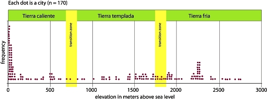
Frequency plot of city elevations in Mexico. Credit: Geo-Mexico

Frequency plot of city elevations in Mexico. Credit: Geo-Mexico

Are there more cities at some elevations than others? Each dot on the graph above represents one of Mexico’s 170 largest cities and towns, plotted against its average elevation. The two major clusters of cities occur at elevations of close to sea level and at 2250 meters, with another smaller, more spread out cluster between 1500 meters and 2000 meters. Perhaps somewhat surprisingly, there are relatively few Mexican cities at elevations of between 100 and 1500 meters (4920 ft.).

  • Q. Can you suggest any reasons for this? [Hint: Look at a relief map of Mexico to see how much land surface there actually is at different elevations].

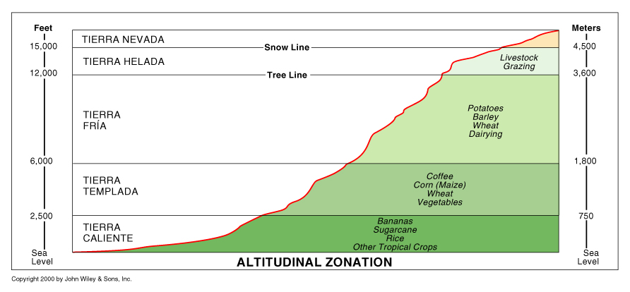
The graph also shows the division of Mexico’s climate and vegetation zones by elevation first proposed by Alexander von Humbuldt following his visit to Mexico in 1803–1804. The terms tierra caliente, tierra templada, and tierra fría are still widely used by non-specialists today to describe the vertical differentiation of Mexico’s climatic and vegetation zones (see cross-section below).

Altitude zones

Altitude zones. Copyright John Wiley & Sons Inc. 2000.

The tierra caliente (hot land) includes all areas under about 900 m (3000 ft). These areas generally have a mean annual temperature above 25°C (77°F). Their natural vegetation is usually either tropical evergreen or tropical deciduous forest. Farms produce tropical crops such as sugar-cane, cacao and bananas. Tierra templada (temperate land) describes the area between 900 and 1800 m (3000 to 6000 ft) where mean annual temperatures are usually between about 18°C and 25°C (64°F to 77°F). The natural vegetation in these zones is temperate forest, such as oak and pine-oak forest. Farms grow crops such as corn (maize), beans, squash, wheat and coffee. Tierra fria (cold land) is over 1800 m (6000 ft) where mean annual temperatures are in the range 13°–18°C (55°–64°F). At these altitudes pine and pine-fir forests are common. Farm crops include barley and potatoes. On the highest mountain tops, above the tierra fría is tierra helada, frosty land.

Interestingly, the tierra templada appears to have fewer cities than might be expected. Equally, while archaeologists have sometimes argued for the advantages of siting settlements close to the transition zone between climates, where a variety of produce from very distinct climates might be traded, the graph shows no evidence for this.

It would be misleading to read too much into this superficial analysis of the elevations of Mexican settlements. First, we have only considered the 170 largest settlements. Second, an individual settlement may extend over a range of elevation, so using an average figure does not reveal the entire picture. Thirdly, the precise elevations for tierra caliente, templada and fria all depend on the latitude and other local factors. Even so, it might be interesting to extend this analysis at some future time to include far more settlements to see if the patterns identified are still present or if others emerge.

Related posts:

Value of remittances entering Mexico declines in 2012

 Updates to Geo-Mexico  Comments Off on Value of remittances entering Mexico declines in 2012
Feb 042013
 

Mexico’s central bank has released figures showing that remittances entering Mexico in 2012 totalled $22.446 billion, 1.57% less than the $22.803 billion  recorded in 2011. [All figures in US dollars.]

The central bank registered 71.62 million remittance movements in 2012, 2.52% more than the year before. The average remittance fell by about 4% from $326 in 2011 to $313 in 2012.

The state receiving most remittances was Michoacán which accounted for $2.209 billion, almost 10% of the total.

Remittances are the second largest source of foreign exchange after oil and gas revenues and are a vital source of funding for millions of people.

Related posts:

Cyclists retaking the streets of Guadalajara

 Books and resources, Mexico's geography in the Press  Comments Off on Cyclists retaking the streets of Guadalajara
Feb 022013
 

The popularity of cycling is growing rapidly in several Mexico cities. Mexico City has created bike lanes, an Ecobici system for short-distance hires, and holds numerous cycling events and rallies, designed to appeal to the whole family, not just to commuters.

Guadalajara, Mexico’s second largest city, now has a higher density of car use than Mexico City, according to “Over the Wheel—Mexico“, a documentary made recently for Aljazeera TV by Juan Pablo Rojas. Rojas, a native of the city, is a long-time film maker. He focuses his documentaries “on those sectors of society that are promoting new paradigms of life based on social equality, awareness, development, conservation and sustainability.”

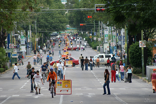
Via RecreActiva in Guadalajara. Photo by supernova.gdl.mx

Via RecreActiva in Guadalajara. Photo by supernova.gdl.mx

Over the Wheel—Mexico” takes a look at the growing cycling culture in Guadalajara, a city of some four million people and almost two million motor vehicles. It looks at the dedicated work of several committed groups of activists, such as GDL en bici [Guadalajara by bike],  who are striving to persuade car owners to change their habits and make the streets safer for alternative, cleaner corms of transport such as bicycles. Among other things, the activists have begun a “bicicleta blanca” movement in which white-painted bicycles are mounted as a memorial wherever a cyclist is killed in a traffic accident.

Can cyclists reclaim the streets of Guadalajara from cars? This 25-minute documentary, which has Spanish language commentary and English subtitles, looks at how a quiet revolution in sustainable urban transport is slowly unfolding in Guadalajara.

Further evidence of the growing popularity of cycling in Guadalajara is provided by the success of the weekly “Via RecreActiva” (see image). Every Sunday, city officials close over 65 km (40 mi) of city streets to motorized vehicles for six hours from 8 a.m. to 2 p.m. Up to 200,000 people take over the streets. Most are on bicycles, but others are walking, jogging, rollerblading or skateboarding.

Want to read more?

Related posts: