Feb 242011
 

Mexico is the world’s seventh largest coffee producer and one of the leading suppliers of organic, shade-grown coffee. The nation’s 480,000 coffee growers, most working small parcels of land less than 5 hectares (12 acres) in size, are concentrated in Chiapas, Veracruz and Oaxaca, and produce 268,000 metric tons a year. While Mexican coffee consumption per person is rising, 62% of the harvest is exported, bringing in $400 million annually.

This year’s crop escaped the deep freeze in late January and early February that decimated corn, tomatoes, bell peppers and other crops in northern Mexico, but unseasonal rains and cold weather in coffee-growing regions of southern and eastern Mexico have reduced coffee yields and mean that this season’s crop is also ripening unevenly. Some growers are worried that this could be the worst coffee harvest in almost 20 years.

Mexico's exports: coffee

Coffee, one of Mexico's most important agricultural exports

With fewer berries on each plant, the potential earnings for coffee-pickers are poor, since it takes longer to fill each basket with ripe berries. Some experienced coffee pickers are looking for alternative employment hoping for better pay. According to growers, the less experienced pickers remaining on the job are causing more damage to the bushes than normal, because they employ a hand picking method known as “ordeñando” (milking) in which they run their hands rapidly along a branch, stripping away the leaves as well as the beans. The problem for growers is that this technique reduces the following year’s crop.

The 2010-2011 harvest season began in October. Government officials are still estimating a harvest of 4.4 million 60-kg sacks, which would be a total of about 264,000 metric tons. However, Agroindustrias Unidas de México, Mexico’s largest coffee exporter, believes that 3.5 million sacks will be nearer the truth. If the exporter is correct, the current harvest would be only marginally better than Mexico’s 1992-1993 harvest which was the lowest in the past twenty years.

The only silver lining in this cloud is that coffee prices on international markets are high and rising, mainly due to problems in Colombia, so Mexican growers have a good incentive to pick every single ripe berry they can find.

Cold weather wreaks havoc on crops in Sinaloa, Mexico

 Mexico's geography in the Press  Comments Off on Cold weather wreaks havoc on crops in Sinaloa, Mexico
Feb 212011
 

Corn production has been the core of Mexican agriculture throughout its history, and continues to be very important. Production has increased by more than 40% since 2000. Currently corn is grown on about half of all agricultural land. However, corn is a rather low value crop and accounts for only about 14% of total crop value.

Corn, for both human and livestock consumption, is grown virtually everywhere in Mexico and is the leading crop in 17 of the 32 states. The leader in volume of corn produced is Sinaloa with 28% of the national total. Other major corn states are Jalisco (12%), State of Mexico (6%), Michoacán, Guanajuato and Guerrero (5% each).

The unusually cold weather in early February 2011 hit farming areas in northern Mexico particularly hard. Farmers in Sinaloa, the “Bread Basket of Mexico,” report that 300,000 hectares (750,000 acres) of corn were destroyed after unusually cold temperatures in the first few weeks of the year. A further 300,000 hectares suffered some damage. Sinaloa has 470,000 hectares of farmland devoted to the white corn used to make tortillas; 90% of this area has been damaged. Heriberto Felix Guerra, federal Secretary for Social Development (SEDESOL) called the weather-related losses the worst disaster in Sinaloa’s history. The economic loss could exceed three billion dollars.

The federal Agriculture Secretariat is rushing urgent aid to farmers, including tax breaks and low-interest loans for seed, in the hopes that many of them can replant their corn crop while there is still time. As of today, more than 130,000 hectares of corn in Sinaloa have already been replanted. The aim is to reseed between 200,000 and 300,000 ha (500,000-750,000 acres) of corn, for an eventual harvest (in Sinaloa) of 3 million metric tons of corn. The reseeding must be completed by 10 March as, after that date, there are too few “growing days” to guarantee a harvest. Average yields in Sinaloa for white corn are expected to fall from their usual 10 tons/ha to around 7 tons/ha this year.

Mexico has an annual shortfall in corn production and always has to import some corn (mainly from the USA and South Africa) to meet total domestic demand. This year, the government is considering raising its usual import quotas to ensure ample supplies of corn (and tortillas) for the coming year. Corn prices have already shot up; Mexico’s imports are going to cost a lot more than in recent years.

Citrus orchards, tomato crops and other vegetables were also decimated. Tomatoes are by far the most important horticultural crop in Sinaloa, but other crops affected include green beans, squash and chiles. It will be another 6 weeks to 2 months before another tomato harvest is possible. The price of tomatoes also rose immediately and could double, at least temporarily, within the next few weeks.

The Mexican tomato crop is mainly the larger Roma variety which is widely used in the fast food industry. Already at least one fast-food chain in the USA is adding tomato slices to hamburgers only on request; the smaller tomatoes used in salads are not affected by the recent cold snap.

Previous related posts:

Feb 142011
 

The January 2011 issue of Scientific American contains “Casualties of Climate Change” which takes an in-depth look at three case studies (Mozambique, Mekong Delta and Mexico) where (according to the authors) climate-forced migrations will be inevitable in the next 70 years.

The article combines research which formed part of the European Commission’s Environmental Change and Forced Migration Scenarios project (EACH-FOR), a global study on environmentally induced migration, with maps produced by the Center for International Earth Science Information Network (CIESIN) at Columbia’s Earth Institute.

In the case of Mexico, the case study suggests that the declining rainfalls and decreasing water availability resulting from climate change will lead to more frequent and more prolonged droughts, especially in central and western Mexico, alongside an increase in the frequency and severity of tropical storms and hurricanes. The authors cite evidence from interviews in the state of Tlaxcala that some climate-induced migration is already under way, as rainfall totals and timing have become less predictable.

Of course, predicting what the climate in Mexico (and elsewhere) will be like in 2080 is a decidedly risky undertaking. At best, such predictions are a statistical guesstimate. Even so, it is still useful to consider alternative climate change scenarios, together with their likely impacts on  environmental hazards and future movements of people. Looking at the alternatives may allow the development of strategies and policies which can reduce or minimize the adverse  social, human, economic and environmental impacts.

Four colorful maps accompany the Mexico case study:

  • population density
  • rain-fed agricultural land
  • incidence of drought
  • predicted change in runoff.

The downside: In some instances, data given in the text appears to conflict with the data shown on these maps. Furthermore, no definition for “drought” is offered in either the text or the relevant map. The drought map’s categories are stated to be “percent of growing season that experienced drought, 1988-2007) but some methodological clarification of the underlying assumptions made and how these figures were calculated would have greatly enhanced the map’s value.

Previous posts about climate change in Mexico:

Mexico’s environmental trends and issues are examined in chapter 30 of Geo-Mexico: the geography and dynamics of modern Mexico. Ask your library to buy a copy of this handy reference guide to all aspects of Mexico’s geography today! Better yet, purchase your own copy…

Are the residents of Ciudad Nezahualcóyotl becoming middle class?

 Mexico's geography in the Press  Comments Off on Are the residents of Ciudad Nezahualcóyotl becoming middle class?
Feb 062011
 

In a previous post –Nezahualcoyotl, an irregular settlement which grew into a monster – we looked at the extraordinarily rapid growth of Ciudad Nezahualcóyotl (today a city of over 1.5 million inhabitants) from its start on the dried-up lake bed east of Mexico City in the 1950s.

Nezahualcoyotl, the city of dreams

Nezahualcoyotl, the city of dreams, now has its own Sears and Wal-Mart

The Economist special report on Latin America (11 September 2010) included an evocative description of Ciudad Nezahualcóyotl, well worth reading. It describes how “an impoverished settlement of dirt streets and one-storey shacks built of grey concrete blocks” [ed: see photo] has become “comfortable homes of two or three storeys” with asphalted streets and “traffic-clogged thoroughfares… lined with businesses of every type”. Next to a Wal-Mart and private hospital is a shopping center with Sears and C&A, boutiques and a multiplex cinema.

The inhabitants aspirations have changed from bicycles to private cars, and include hopes of a higher education and finding a well-paid position elsewhere. The article concludes that the rise in living standards of many of the people is (arguably) creating  a “middle class” society, before examining the concept of “middle class” in much more depth.

USA agrees to “bank” some of Mexico’s entitlement of Colorado River water

 Mexico's geography in the Press  Comments Off on USA agrees to “bank” some of Mexico’s entitlement of Colorado River water
Jan 222011
 

In an earlier post, we described a 1944 treaty that guaranteed Mexico would receive at least 1750 million cubic meters of water  each year along the Colorado River (via the Morelos diversionary dam in the Mexicali Valley). However, in April 2010, the Mexicali area was rattled by a large earthquake, so powerful that it moved the southern part of California,  and severely damaged the irrigation infrastructure used by Mexican farmers on land in the lower Colorado River valley and the Colorado River delta. In all, 640 kilometers of irrigation canals were damaged, affecting 60,000 hectares of farmland.

The damaged infrastructure meant that Mexico was unable to use effectively its total annual allocation of water. Even as urgent repairs were begun on pumps, pipelines and irrigation channels in the Mexicali region, Mexican authorities opened talks with the USA to discuss the possibility of deferring receipt of  some of their annual water quota.

The two governments have now agreed “Minute 318” which permits Mexico to decrease its consumption from 2010 to 2013 and then receive the “saved” water later when the irrigation channels are all operational again.

Another major related development concerning the Colorado River is also now getting underway. The two governments are starting talks this year towards a comprehensive new long-term bilateral agreement covering the management of the Colorado River.

Mexico’s water resources and water-related issues are the subject of chapters 6 and 7 of Geo-Mexico: the geography and dynamics of modern Mexico. Ask your library to buy a copy of this handy reference guide to all aspects of Mexico’s geography today! Better yet, order your own copy…

Jan 212011
 

Mexico’s Agriculture Secretariat (SAGARPA) has refused permission for transnational seed firm Monsanto to undertake larger-scale field trials of its GM corn in Sinaloa, and is opposing similar projects involving transgenic corn in Sonora and Tamaulipas. Monsanto is appealing SAGARPA’s initial decision. The other firms hoping to hold second-stage trials besides Monsanto are Dow Agrosciences (a unit of Dow Chemical Co.) and Pioneer Hi-Bred International (currently owned by DuPont).

Yum Kaax, the Mayan god of corn

What would Yum Kaax, the Mayan god of corn, think about GM corn?

As we noted in “The debate over GM corn in Mexico“, Mexico does not yet permit the commercialization of any genetically-modified corn, but Monsanto is betting on a relaxation of current rules as Mexico currently has to import large volumes of corn each year in order to satisfy domestic demand. Mexico’s corn imports are expected to rise from 10 to 15 million metric tons by 2020. Corn prices are also likely to rise since an increasing portion of the annual US corn crop is  destined for biofuel production rather than human consumption.

Monsanto argues that Mexico cannot guarantee its future food security unless it embraces the new agro-technology, and is threatening to withdraw 200 million dollars in planned investments over the next five years. A dozen agricultural organizations in the northern Mexico states of Sinaloa, Sonora, Chihuahua and Tamaulipas, have come out in support of Monsanto’s efforts to introduce transgenic corn, arguing that it is the best way for them to increase productivity and therefore becomes more competitive. The growers’ organizations claim that introducing GM crops has given their commercial competitors a competitive advantage in the marketplace.

The Agriculture Secretariat’s position reflects the concerns of farmers in other regions and ecologists who fear that the introduction of GM corn will displace or eradicate some of Mexico’s existing (non-GM) varieties. Protecting existing varieties of corn is the major motive behind the declaration by the governments of the Federal District and the state of Tlaxcala that their jurisdictions  are “GM-free zones”.

More ground cracks appearing in Mexico City and the Valley of Mexico

 Mexico's geography in the Press  Comments Off on More ground cracks appearing in Mexico City and the Valley of Mexico
Jan 192011
 

The continued sinking of some parts of Mexico City in response to the over-extraction of water from underground aquifers, and consequent shrinking of the subsoil, has resulted in dozens of cracks in recent years. As noted in a previous post – Why are some parts of Mexico City sinking into the old lakebed? – some buildings in Mexico City have dropped more than seven meters (23 ft) since 1891.

According to Gabriel Auvinet Guichard, a researcher at the Engineering Institute of the National University (UNAM), cracks are becoming increasingly frequent. The largest cracks are up to 22 meters (72 feet) deep and 30 meters long. The cracks damage buildings and infrastructure (especially roads and water pipes), and have alarmed residents in some areas in the city.

Auvinet’s team at UNAM’s Geoinformatics Laboratory is compiling a database of all known cracks. They plan to produce maps showing the incidence, location and origin of the cracks to help construction companies meet building regulations. The database has records of 380 fissures at present, but is still far from complete.

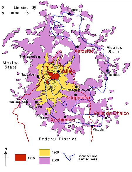
Some areas in the Valley of Mexico are much more prone to the earth movements leading to cracks than others. The areas with a high incidence of cracks include Iztapalapa, Chalco, Xochimilco, Xalostoc and Vallejo (see map).

Mexico City cracks map

Locations in Valley of Mexico with high incidence of ground cracks. Cartography: Tony Burton; all rights reserved.

Chapter 23 of Geo-Mexico: the geography and dynamics of modern Mexico looks at urban issues, problems and trends. To preview more parts of the book, click here and use amazon.com’s “Look Inside” feature.

Mexican drug traffickers expand their influence to Central America

 Mexico's geography in the Press  Comments Off on Mexican drug traffickers expand their influence to Central America
Jan 182011
 

According to an article by Nacha Cattan in The Christian Science Monitor, one of Mexico’s most violent drug gangs, the Zetas, have now expanded into Central America. It is yet another instance of the shifting allegiances which require another redrawing of the “map” showing the cartels’ competing and partially overlapping spheres of influence.

The Zetas started out in the 1990s as a group of ex-military strong-arm enforcers who had previously worked exclusively for Mexico’s Gulf Cartel. The Zetas rapidly established a reputation for extreme brutality, leaving severed heads as a sign of what they would do to anyone who opposed them. By the start of 2010, the Zetas had grown into an independent force controlling ever-increasing areas of north-eastern, central and western Mexico. They were pushed further west and south by an unlikely coalition of the Sinaloa cartel, the Gulf cartel and La Familia Michoacana, known as the New Federation. The Zetas have not limited themselves to drug trafficking, but have gradually extended their field of operations into many kinds of organized crime, especially kidnapping, extortion and the sex trade.

Now it seems that the Zetas have garnered support in Central America, where they have used local former military agents to keep their brand of discipline as they snare poverty-stricken youth into their organization. In Guatemala, the Zetas accused Guatemalan President Alvaro Colom of accepting millions of dollars in drug money, and threatened a sharp rise in civilian casualties if authorities continued to target their activities.

Honduras and El Salvador are also reported to house Zeta cells. This has prompted Mexico and several Central American countries to discuss forming anti-cartel alliances. The links between the Zeta cells in Central America and the hard-line Zeta forces in Mexico remain unclear. While some analysts claim the Zetas move to the south is because of successful law enforcement efforts in Mexico, others suggest that the Zetas are expanding in order to exert complete control over supply routes that originate or cross Central America.

Related posts about drug cartels in Mexico:

Two major aqueducts in the Lerma-Chapala basin

 Mexico's geography in the Press  Comments Off on Two major aqueducts in the Lerma-Chapala basin
Jan 152011
 

Two major new aqueducts will help to ensure reliable water supplies for Guadalajara and León, two rapidly growing cities in the Lerma-Chapala basin.

SIAPA (Sistema Intermunicipal de Agua Potable y Alcantarillado) is the acronym for the water supply system for the city of Guadalajara, Mexico’s second largest metropolitan area (population: 4.4 million). About 60% of Guadalajara’s potable water comes from Lake Chapala, the country’s largest natural lake, via an aqueduct. According to SIAPA Director José Luis Hernández Amaya, this existing aqueduct, built more than 20 years ago, is now inadequate. SIAPA now has construction permits in place to build a second aqueduct supplying water to the city from the lake. The plans for the second aqueduct have been approved by both state and federal regulatory bodies (the Comisión Estatal del Agua and the Comisión Nacional del Agua (Conagua) respectively).

All parties agree that boosting the amount of available water is essential for a city growing as rapidly as Guadalajara. The new aqueduct, likely to cost 2,000 million pesos, will enable the city to undertake maintenance as needed on the pumping stations and channels of both systems. Undertaking maintenance on the existing system without opening a parallel channel would involve cutting off the water supply for up to 60% of Guadalajara’s population for several days.

A new aqueduct is also planned for the city of León. According to recent press reports, the El Zapotillo dam on the Río Verde is about 21% complete. The resulting reservoir will guarantee adequate water supply for León (population: 1.6 million), and reduce its dependence on groundwater abstraction. Tenders are now being accepted for the construction of a 139-km-long aqueduct from El Zapotillo to join León’s potable water system, together with two pumping stations and a water purification plant.

The new reservoir and aqueduct should ensure that León’s water demands are met for between 25 and 30 years. In addition to León, several other municipalities will also benefit from an improved water supply, including Jalostotitlán, San Miguel el Alto, Encarnación de Díaz, San Juan de los Lagos and Lagos de Moreno.

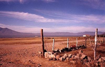
Lake Chapala in 2002

Lake Chapala in 2002, more like a desert than a lake. The lake has since recovered.

Neither plan is without its critics. Activists at Lake Chapala are concerned that supplying more water from the lake to Guadalajara will return the lake to the precarious state it was in during the 1990s. Opponents to El Zapatillo claim that the main demand for water in León is from the new industrial estates and leather tanning plants, and that supplying them with more water will only lead to further serious contamination and even more wastage of the valuable resource.

Rivers, reservoirs and water-related issues are discussed in chapters 6 and 7 of Geo-Mexico: the geography and dynamics of modern Mexico. Ask your library to buy a copy of this handy reference guide to all aspects of Mexico’s geography today! Better yet, order your own copy…

Mexican geophysicists develop new model for hurricane forecasting

 Mexico's geography in the Press  Comments Off on Mexican geophysicists develop new model for hurricane forecasting
Jan 112011
 

The new methods, using physics rather than mathematics as the basis, can be used to forecast the timing of Category 5 hurricanes, the most severe level on the Saffir-Simpson scale.

Category 5 hurricanes have sustained wind speeds of up to 250 km/hr, with catastrophic impacts on homes, lives and infrastructure. The most recent Category 5 hurricanes to strike Mexico are Dean (2007), Wilma (2005), Mitch (1998), Gilbert (1988) and Beulah (1967).

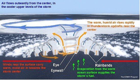
Scientists at the Geophysics Institute of the National University (UNAM) in Mexico City have developed a physics-based model, relying on three-dimensional imaging, which can be used to predict severe (Category 5) hurricanes. They have also pin-pointed precisely where in the deep waters of the Atlantic Ocean severe hurricanes are most likely to originate. The scientists conclude that severe hurricanes do not occur randomly in time, but tend to occur at roughly cyclical intervals, about every ten years.

Diagram showing features of the existing GFDL Hurricane Prediction System

Diagram showing features of the existing GFDL Hurricane Prediction System

They hope that the new techniques will improve the forecasting associated with these severe weather hazards, and offer more lead-in time for the updating and implementation of evacuation plans and other mitigation measures.

Lead investigator Víctor Manuel Velasco Herrera says that, according to the model, the next period when Category 5 hurricanes will occur will begin in 2013 and end in 2017, “with a margin of error of one year.”

Watch this space for updates in due course!

Previous posts related to hurricane prediction:

Hurricanes and other climatological phenomena are analyzed in chapters 4 and 7 of Geo-Mexico: the geography and dynamics of modern Mexico. Buy your copy today, so you have a handy reference guide available whenever you need it.

New aqueduct should guarantee water supply for the city of Hermosillo

 Mexico's geography in the Press  Comments Off on New aqueduct should guarantee water supply for the city of Hermosillo
Jan 082011
 

According to press reports, construction is underway of the “Independence Aqueduct” which will carry water from the Plutarco Elías Calles reservoir on the Yaqui River, in southern Sonora, to Hermosillo, the state’s capital city. The reservoir is the 11th largest in Mexico with a capacity of 2,925 million cubic meters.

Javier Gándara Magaña, the mayor of Hermosillo (population 780,000), expects the 150-km-long aqueduct to be functioning by 2012 though he has warned residents that water brought from the reservoir (commonly known as El Novillo) will be more expensive than that from existing sources. City authorities plan to have installed water meters in every dwelling prior to the completion of the aqueduct.

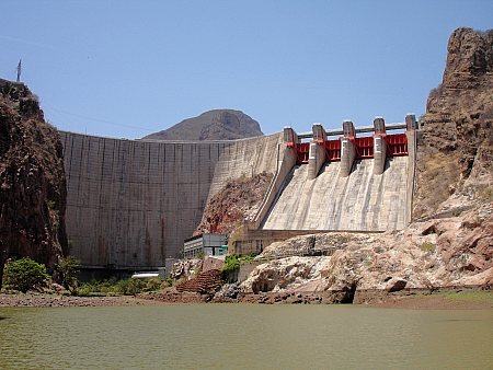
novillo dam sonora

Curtain of El Novillo dam, Sonora

The aqueduct will supply 75 million cubic meters a year to the city, and represents a long-awaited, and long-term, solution to the water problems faced by Hermosillo, which is located in one of the driest regions of the country. At a later stage, the reservoir will also supply 500 million cubic meters a year to the municipality of Cajeme, in the northwest of the state.

Construction of the aqueduct is opposed by many members of the indigenous Yaqui communities and by agricultural producers farming the Yaqui Valley in the south of Sonora who claim that diverting water to Hermosillo will jeopardize the long-term water security for their operations.

Rivers, reservoirs and water-related issues are discussed in chapters 6 and 7 of Geo-Mexico: the geography and dynamics of modern Mexico. Ask your library to buy a copy of this handy reference guide to all aspects of Mexico’s geography today! Better yet, order your own copy…

Mexico’s farm workers move north, US agri-businesses move south…

 Mexico's geography in the Press  Comments Off on Mexico’s farm workers move north, US agri-businesses move south…
Jan 032011
 

Mexican migrant workers have played an important role in US agriculture for decades, especially during harvest time, when they fill temporary menial and low-paid positions.

In recent years, border restrictions and periodic US crack-downs on the employment of undocumented workers have reduced the number of Mexicans seeking seasonal jobs north of the border. This has apparently resulted in some US agricultural enterprises deciding to shift their production centers into Mexico – if the workers won’t come to the farms, then the farms have to come to the workers…

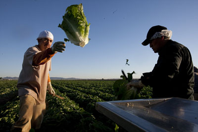
Lettuce farm

Steve Scaroni's lettuce farm. Photo: Janet Jarman, The World.

One example, that of a major lettuce grower, is described in detail in the Public Radio International’s The World program American farmers move to Mexico, which includes an interesting audio clip of Steve Scaroni describing why he’s moved half his lettuce-growing business south to the state of Guanajuato.

Scaroni’s company plants, harvests and processes 20 million servings of lettuce each week, mostly distributed via US supermarkets.

Scaroni compares the pay of each field worker in Arizona or California of $9-$10 an hour, with the $12 to $15 he pays in Mexico per day. Wage differentials are not the only advantage. Geographical diversification into Mexico also spreads the risk (and increases his firm’s resilience) in the event of adverse weather conditions.

On the flip side, Scaroni has to cope with added transportation costs, the complexities of the Mexican tax system, and supply problems for vital inputs such as fertilizers.

Scaroni supports a proposed US immigration bill known as “AgJobs” which would give farm workers more rights, offer a path to legal status, and make it easier for American farmers to bring in temporary immigrant workers.

Mexico’s agriculture is analyzed in chapter 15 of Geo-Mexico: the geography and dynamics of modern Mexico. and concepts of sustainability are explored in chapters 19 and 30.  Buy your copy today, so you have this handy reference guide to all aspects of Mexico’s geography available whenever you need it.

On-going changes in the migration landscape of Tijuana, Baja California

 Mexico's geography in the Press  Comments Off on On-going changes in the migration landscape of Tijuana, Baja California
Jan 012011
 

An interesting recent Salem-News.com article summarizes the effects on the migration landscape of the city of Tijuana, Baja California, of the USA’s imposition of tighter border controls, including walls, fences and helicopter patrols.

There is no question that the economic downturn since 2008 and toughened border controls have reduced the number of migrants entering the USA. However, this has channeled the most determined would-be migrants into more challenging (and often more dangerous) options. It has also pushed the costs up. Twenty years ago, a few hundred dollars was probably sufficient to enlist the help of a “pollero” to cross the border undetected. Today, border gangs want several thousand dollars from each undocumented migrant who seeks their assistance.

Three favored options for crossing the border:

  • pay a smuggling gang $2,000 – $3,000 for a trip across the desert or mountains between Mexicali and Arizona.
  • pay up to $7,000 for a trip through one of the narco-tunnels (used mainly by drug smugglers)
  • pay up to $8,000 for a place on a high-speed boat leaving from Rosarito Beach and landing somewhere on the California coastline
  • the alternative is a dangerous solo hike across desert or mountains, through areas where many migrants have lost their lives.

Border security changes have had some major effects on Tijuana:

  • many migrants are unable to cross, swelling the numbers of poorly skilled workers in the Tijuana workforce. With insufficient formal sector jobs for all these workers, many enter the murky worlds of pornography, drug trafficking and the sex trade.
  • those unable to migrate tend to live in Tijuana’s lowest-income neighborhoods such as Valle Verde, Obrera, Lomas Taurinas, La Esperanza, El Niño and La Morita, which are growing very rapidly
  • more power has been gained by the organized gangs of traffickers, since they are the only ones with the resources to help undocumented migrants attempt to cross the border

Previous posts related to Mexican migrants in the USA:

Migration between Mexico and the USA is the focus of chapter 25 of Geo-Mexico: the geography and dynamics of modern Mexico. Ask your library to buy a copy of this handy reference guide to all aspects of Mexico’s geography today! Better yet, order your own copy…

Updates on the geography of Mexico City

 Mexico's geography in the Press  Comments Off on Updates on the geography of Mexico City
Dec 132010
 

We start this periodic round-ups of news items related to the geography of Mexico City with an update on Mexico City’s population. The preliminary results of the 2010 census show that the Mexico City Metropolitan Area (MCMA) has a population of 20,137,152. This includes the Federal District with its 8,873,017 inhabitants. The Federal District has grown only slowly since 2000, but the State of Mexico, much of which is included in the MCMA, grew five times as quickly (its growth was 1.59%/yr between 2000 and 2010).

New electric Nissan taxis

Several hundred all-electric taxis will soon be circulating in Mexico City. In the second half of 2011, 500 Nissan “Leaf”s (Leading, Environmentally friendly, Affordable, Family cars) will be added to the city’s massive taxi fleet. When fully charged, the Leaf has a range of up to 160km, with zero emissions of CO2. Nissan is reported to be installing recharging stations in locations such as supermarket and restaurant parking lots. The Leaf is expected to go on sale to the public in 2012.

Fines for using non-biodegradable plastic bags

Mexico City authorities have dropped the possibility of  jail time, but kept stiff fines for anyone using plastic bags that are not bio-degradable. Store owners and employees are no longer allowed to give away non-biodegradable plastic bags. Repeat offenders will face fines of up to 9,250 dollars.

Levies on excess garbage

Watch out big business! Mexico City authorities have announced a crack-down on the solid wastes generated by large commercial enterprises, including shopping centers. About 2,000 places will be inspected; they currently pay about 1.2 million dollars (15 million pesos) a year in excess waste fees, but the city believes many are abusing the system, which is based on self-reporting. Mexico City’s solid waste regulations classify anyone disposing of more than 50 kg a day as a “high volume waste generator.” Anyone in this category must pay for every kilogram of waste beyond the basic 50 kilos. The current rates (per kilogram) are 0.50 pesos for construction materials, 1.00 pesos for urban waste, 1.83 pesos for plant-related waste and 2.20 pesos for wastes requiring special handling. Businesses will be audited by city inspectors to ensure that the amount of waste they produce matches what they officially report, and fines will be levied for non-compliance.

The geography of Mexico City is analyzed in chapters 21, 22 and 23 of  Geo-Mexico: the geography and dynamics of modern Mexico. Ask your library to buy a copy of this handy reference guide to all aspects of Mexico’s geography today! Better yet, order your own copy…

Dec 102010
 

Mexico’s economy, the world’s 11th largest, is growing rapidly and predicted by many analysts to become the world’s fifth largest by 2050. It is not, therefore, surprising that, according to a recent report on key emerging markets from Spanish bank BBVA, investments in emerging markets are assuming more and more importance. However, the all-encompassing term “emerging market” covers a multitude of countries whose individual economies are incredibly diverse. It includes not only major economies such as those of China, India and Mexico, but also a host of tiny island states such as Grenada, Vanuatu and the Seychelles.

BRICs or EAGLE

BRICs or EAGLE?

Economists have suggested various sub-groupings of emerging markets. One of the most commonly used in geography is BRIC, an acronym formed from the initial letters of Brazil, Russia, India and China. The term BRIC was first coined by  Jim O’Neill in a 2001 paper entitled “The World Needs Better Economic BRICs”. The concept of BRICs has become outdated as the four countries’ economies have diverged over the past decade. Any term comprised of country names will inevitably date fairly quickly, and become much less useful.

Now, BBVA has proposed the use of the term EAGLE to cover the world’s Emerging and Growth-Leading Economies. The member states of this exclusive EAGLEs club are:

  • China
  • India
  • Brazil
  • Russia
  • South Korea
  • Indonesia
  • Mexico
  • Turkey
  • Eqypt
  • Taiwan

These ten countries are each expected to contribute more to global economic growth than the average of G7 members. Combined, the ten EAGLEs are  expected to account for 50% of all global growth in the next 10 years.

A further eleven countries—Nigeria, Poland, South Africa, Thailand, Colombia, Vietnam, Bangladesh, Malaysia, Argentina, Peru and the Philippines—are identified by BBVA as having the potential to join the EAGLEs if their economies grow more than expected.

The BRIC is dead! The EAGLEs are rising! Long live the EAGLEs!

Mexico’s economy and workforce are analyzed in chapters 14 to 20 of Geo-Mexico: the geography and dynamics of modern Mexico. Ask your library to buy a copy of this handy reference guide to all aspects of Mexico’s geography today! Better yet, order your own copy…

Dec 062010
 

Cancún is Mexico’s premier tourist destination, attracting more than 3 million visitors a year. A recent Associated Press report by Mark Stevenson highlights the problems faced by the resort due to the erosion of its beaches.

Cancún was developed on formerly uninhabited barrier islands on Mexico’s Caribbean coast. The islands were low-lying sand bars, held together by beach vines and the dense, interlocking roots of coastal mangroves. Hurricanes periodically swept over these small islands blowing loose sand towards the beaches on the mainland. Despite the occasional hurricane, the sandbars survived more or less unscathed until construction of Cancún, Mexico’s first purpose-built tourist resort, began in 1970.

As Cancún has grown, so the damage from hurricanes has become more serious. Category 4 Wilma in 2005 was especially destructive.

Cancún beach erosion

Cancún beach erosion. Photo: Dario Lopez-Mills/AP

Why has hurricane damage increased since 1970? Several factors are thought to play in a part in causing the increased rate of erosion of Cancún’s beaches in recent years:

  • hotels have been built too close to the shore, and too many are high-rise buildings. High-rise hotels deflect some of the wind downwards towards the ground. These wind eddies can stir up any dry surface sand in a process known as deflation.
  • hotels are too heavy. The sheer weight of high-rise hotels compacts the largely unconsolidated sediments beneath them, rendering the sediments less able to store or absorb excess water, and more liable to subsidence and structural problems. Extra weight also increases the load on slopes and leads to a higher incidence of slope failure.
  • coastal mangroves have been destroyed, removing their ability to protect the shoreline during storm events.
  • most beaches have been stripped of their original vegetation. The original beaches were protected by various adventitious vines which were quick to colonize bare sand. They would simultaneously help hold the sand in place, protecting it from wind action, and gradually add to the organic content of beaches to a point where they could support other, larger plants. Native vegetation has been mercilessly eradicated from Cancún’s beaches to create the tourism “ideal” of uninterrupted swathes of white sand.

It also appears that hurricanes and other tropical storms have become more frequent in recent decades, perhaps as a consequence of global climate change. The situation has also been exacerbated by the gradually rising sea level. Sea level on this coast is rising at about 2.2 mm/y.

Why have some of the efforts made to mitigate the beach erosion only made the situation even worse?

Following strong hurricanes (such as Wilma in 2005) Cancún has lost most of its beaches. The first attempt at beach restoration in 2006 cost 19 million dollars. In 2009, an even costlier (70 million dollar) beach restoration was carried out, using sand dredged from offshore. In one sense, the project was a resounding success. A new beach up to 60 meters wide, was created along some 10 km of coastline.

However, this new beach came at a considerable ecological cost. The pumping of sand from offshore disturbed the seafloor and damaged sealife, including populations of octupus and sea cucumbers. Fine sediments raised by the pumping traveled in suspension to nearby coral reefs, where it also had deleterious impacts.

In addition, the new beach is already being eroded away (some estimates are that up to 8% of the new sand has already been washed or blown away), so presumably if Cancún’s beaches are to be maintained in the future, beach restoration will have to become a regular event.

One hotel erected a breakwater or groyne on its beach to retain all the sand being carried along the coast by the process of longshore drift. The Associate Press article ends with a wonderful story of how the beach in front of this particular hotel was cordoned off by marines last year on the grounds that it was stolen property.

Link to 2013 news article: A fortune made of sand: How climate change is destroying Cancun

Tourism is one of Mexico’s major sources of revenue. But tourism, especially high-rise mass tourism such as that characterized by Cancún, comes with a hefty price tag. Policy-makers need to decide whether this price tag, which will only rise further in the future as we continue to damage our natural environment, is really one that is worth the cost.

Chapter 19 of Geo-Mexico: the geography and dynamics of modern Mexico looks in much more detail at Mexico’s purpose-built resorts as well as many other  aspects of tourism, resorts and hotels  in Mexico. Chapter 30 focuses on environmental issues and trends. Buy your copy today!

The 2010 United Nations Climate Change Conference in Cancún, Mexico

 Mexico's geography in the Press  Comments Off on The 2010 United Nations Climate Change Conference in Cancún, Mexico
Dec 012010
 

The 2010 United Nations Climate Change Conference is now underway in Cancún, Mexico. It began 29 November and closes 10 December 2010. One of the objectives that Mexico hopes to achieve is the setting up of a Global Green Fund to help nations adversely affected by climate change to finance projects of mitigation and adaptation.

IPCC CancunAt the 2009 round of talks, in Copenhagen, Denmark, the countries present failed to agree any significant actions, choosing instead to sign a non-binding agreement and “agree to disagree”.

Prior to the Cancún meeting, four preparatory rounds of negotiations have already been held in 2010. The first three rounds were in Bonn, Germany:  April 9-11;  June 1 – 11; and August 2 – 6. After the August meeting, UN Secretary-General Ban Ki-Moon publicly doubted that member states would reach any new agreement on global warming at the Cancún Conference.

The fourth preparatory round of talks, held in Tianjin, China, also made minimal progress as the USA and China could not agree on key issues. However, following that meeting, Christiana Figueres, Executive Secretary of the UN Framework Convention on Climate Change (UNFCCC), said, “This week has got us closer to a structured set of decisions that can be agreed in Cancún … This is the greatest societal and economic transformation that the world has ever seen.” Other commentators have also spoken of a positive spirit of negotiation, which will hopefully pave the way for an agreement to be reached in Cancún.

We will have to wait until the conclusion of the Cancún Conference before assessing its success or lack thereof, but let us hope that the delegates can this year come to some meaningful, and binding decisions.

Previous posts about global warming:

Mexico’s environmental trends and issues are examined in chapter 30 of Geo-Mexico: the geography and dynamics of modern Mexico. Ask your library to buy a copy of this handy reference guide to all aspects of Mexico’s geography today! Better yet, purchase your own copy…

Subsidence incident leads to demolition of 31 homes in the State of Mexico

 Mexico's geography in the Press  Comments Off on Subsidence incident leads to demolition of 31 homes in the State of Mexico
Nov 302010
 

Thirty-one homes have been demolished due to structural damage resulting from subsidence in the colonia Benito Juárez. The subsidence, on 28 October 2010, occurred close to the Neza II garbage tip and affected more than 200 homes in total.

Temporary accommodation has been found for the families affected, who will have their rents of up to 2,000 pesos a month paid for the first six months. The compensation to be paid to the affected families from government coffers is still being decided.

Geologists and engineers from the Universidad Nacional Autónoma de Mexico (UNAM) y el Instituto Politécnico Nacional (IPN), are currently assessing the risks of alternative sites for rebuilding the 31 homes. Several areas of Nezahualcóyotl are known to be vulnerable to subsidence or to the sudden appearance of surface cracks (superficial faults).

The subsidence is presumed to have occurred because of the filtration of liquids from the Neza II tip through the subsoil, though precise details are still being investigated. To prevent further problems in the area, pipes are being installed to channel all liquid residues away from homes, and vents are being placed to allow the escape of gases emanating from within the garbage tip.

The three settlements of Nezahualcóyotl, Chimalhuacán and Los Reyes La Paz add about 1,000 tons of garbage daily to the Neza II tip. Authorities are now planning to close the tip completely by the end of November 2010.

Elsewhere in Nezahualcóyotl, the structural integrity of a shopping center and sports complex located near the Neza I tip are also being investigated.

The fact that subsidence occurs far more frequently in the eastern part of Mexico City (including Nezahualcóyotl) than elsewhere does not indicate that the solutions must be local. Ramón Aguirre, the director of Mexico City’s Water System (Sistema de Aguas de la Ciudad de México), has repeatedly emphasized the importance of looking at Mexico City’s potable water and drainage problems in the context of the entire metropolitan area (which extends well beyond the boundary of the Federal District). Aguirre fears that climate change and further over-exploitation of the aquifers, which Mexico City shares with the State of México, will only lead to more problems of water supply and more cases of subsidence.

Chapter 23 of Geo-Mexico: the geography and dynamics of modern Mexico looks at urban issues, problems and trends. To preview more parts of the book, click here and use amazon.com’s “Look Inside” feature.

Nov 292010
 

According to the Environment Ministry, Mexico generates 94,800 tons of garbage a day, which equates to 34.6 million tons a year. Of this total, 53% is organic and 28% recyclable (paper and cardboard 14% of total garbage, glass 6%, plastics 4%, metals 3% and textiles 1%). The remaining 19% of total waste is comprised of non-recyclable construction waste, leather, rubber and miscellaneous other items.

Authorities claim that 87% of all wastes are now collected but, unfortunately, only about 60% ends up in authorized landfills.

Previous posts about garbage”

Mexico’s environmental trends and issues are examined in chapter 30 of Geo-Mexico: the geography and dynamics of modern Mexico. Ask your library to buy a copy of this handy reference guide to all aspects of Mexico’s geography today! Better yet, purchase your own copy…

Mexican migrants pay 53 billion dollars a year in US taxes

 Mexico's geography in the Press  Comments Off on Mexican migrants pay 53 billion dollars a year in US taxes
Nov 272010
 

Mexicans migrate to the USA looking for work and higher salaries, but those workers pay 53 billion dollars a year in taxes, according to Ignacio Deschamps, head of the Fundación BBVA Bancomer. (The BBVA Bancomer Foundation has helped 20,000 young people in 143 municipalities complete their high school education.)

Deschamps claims that for every dollar sent home in remittances, Mexican workers will have already paid 2.50 dollars in US taxes. Hence, in 2008, they would have contributed 53 billion dollars to the US Treasury.

Recent figures show that during the economic downturn, unemployment among Mexican migrants is much higher (13%) than for the workforce as a whole (10%).

Previous posts related to Mexican migrants in the USA:

Migration between Mexico and the USA is the focus of chapter 25 of Geo-Mexico: the geography and dynamics of modern Mexico. Ask your library to buy a copy of this handy reference guide to all aspects of Mexico’s geography today! Better yet, order your own copy…

Mexico and USA agree to talk about oil rights in the Gulf of Mexico’s “Western Doughnut Hole”

 Books and resources, Mexico's geography in the Press  Comments Off on Mexico and USA agree to talk about oil rights in the Gulf of Mexico’s “Western Doughnut Hole”
Nov 152010
 

In 1970, the UN Law of the Sea Convention formally awarded each country the right to natural resources in its 200-mile (322 km) Exclusive Economic Zone (EEZ). Where claims overlapped, the Law of the Sea requires the competing countries to negotiate separate bilateral or multilateral agreements.

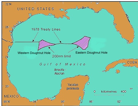
By 1979, the US and Mexico had agreed a treaty governing the basic delimitation of their respective EEZs. However, the treaty was never ratified by the US Senate. While the treaty had fixed seven points on the boundary, there were still two areas where the countries’ claims overlapped. The two portions were called the Western and Eastern Polygons (or Gaps), but were quickly nicknamed the Doughnut Holes. Together they straddle about 200 km of border.

The Western Doughnut Hole has a surface area of 17,467 square kilometers (6,744 square miles). The Eastern Doughnut Hole is about 20,000 square kilometers (7,720 square miles) and partially overlaps with the EEZ of Cuba.

location of doughnut holesTo date, no deposits of hydrocarbons have yet been found which straddle the maritime boundary, even though the Western Doughnut Hole is thought to hold untapped reserves of oil and gas. However, oil wells on one side of the boundary would likely extract some oil from the other side, hence the potential for conflict. In a parody of US politician Ross Perot’s famous 1992 line about the likely impact of the North American Free Trade Agreement (NAFTA) which would cause “a giant sucking sound” as US jobs moved south to Mexico, Mexican journalists have described the likely result of drilling in the Doughnut Hole as a “giant sucking sound” as US firms used their superior deep-water technology to suck up Mexican oil from the other side of the border.

Presidents Calderón and Obama agreed in May 2010 to extend the moratorium on any oil exploration drilling in the Western Polygon until January 2014, giving both sides time to hold joint discussions towards a permanent agreement.

The major oil spill from Deepwater Horizon has helped drive both governments to prioritize joint regulations governing oil and gas activities close to their shared border. Discussions are expected to cover not only deep water oil extraction, but also shallow water activities, including resources other than oil and gas.

For more details, see these two articles by Javier H. Estrada Estrada, Analitica Energética S.C.:

The changing political frontiers of Mexico are the subject of chapter 12 of Geo-Mexico: the geography and dynamics of modern Mexico. Oil reserves and exploitation are discussed in chapter 15.  If you have enjoyed this post, please consider purchasing a copy of Geo-Mexico so that you have your own handy reference guide to all aspects of Mexico’s geography.

The nondescript city of Zitácuaro, Michoacán, is the unhappy star of a New Yorker article

 Mexico's geography in the Press  Comments Off on The nondescript city of Zitácuaro, Michoacán, is the unhappy star of a New Yorker article
Nov 132010
 

The city of Zitácuaro in the state of Michoacán had played an important part in Mexican history (hence its full official name of Heróica Zitácuaro) but was largely ignored by tourists until the early 1980s. Things changed, and tourists started coming, when the locations of the Monarch butterfly overwintering sites were first published. The Monarchs had been undertaking their amazing annual migration from Canada and the USA to the rugged mountains close to Zitácuaro for hundreds, possibly thousands of years, but it was only in the early 1980s when articles in newspapers and science journals first provided locational details.

The Monarch butterflies have since become one of the major ecotourist attractions in this part of Mexico. On a single day in February, more than 5,000 tourists enter the main Monarch reserve El Rosario, accessed from either Angangueo or Ocampo, about 40 minutes driving time from Zitácuaro. Hotels in this area have done well out of the annual November-March “butterfly season”. Indeed, the demand led to the construction of several new hotels in the area, some of them more than large enough to handle tourist groups arriving by the coachload.

In 1980, I began leading regular fieldtrips to Zitácuaro and its surrounds, the major attractions being wonderful scenery and an interesting mix of settlement types, covering everything from 4-hut hamlets to the medium-sized city of Zitácuaro, which had a population at the time of about 100,000.  Over the years, I’ve watched Zitácuaro grow into a much larger city. When the bypass was first built, and federal Highway 15 rerouted around the town instead of along Avenida Revolución, it was ignored by most motorists, who preferred to drive through the city, often stopping for gas or food before continuing their journey. Within a few years, services had begun to spring up, as if by magic, alongside the bypass. Today, the city has spread well beyond the confines of the bypass.

In recent years, violence related to drug trafficking has reached the city. This is perhaps somewhat surprising, given its location far from the USA border, and far from the traditional territories of the main drug cartels. But, as we saw in an earlier post (The geography of drug trafficking in Mexico),  Zitácuaro is very close to the edge of the “territories in dispute” immediately to the west of Mexico City. Violence in these areas is growing as rival groups seek to control the lucrative drug trade. The La Familia crime group is responsible for most drug-related violence in Michoacán.

An article in the New Yorker earlier this year described in detail how La Familia has increasingly threatened the rule of law in  Zitácuaro. The article serves as a good introduction to how an ordinary Mexican city – in this case Zitácuaro – can be dramatically changed by a committed and ruthless criminal group.

An overview of the geography of drug trafficking in Mexico forms part of chapter 20 of Geo-Mexico: the geography and dynamics of modern Mexico. Buy your copy today!

Related post about drug cartels in Mexico:

Resistance to government-sponsored change in Chiapas, Mexico

 Mexico's geography in the Press  Comments Off on Resistance to government-sponsored change in Chiapas, Mexico
Oct 292010
 

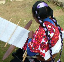
Kudos to the the New Mexico-based Grassroots Press, for the enticing title “Weaving Webs of Resistance in Chiapas” on an article by Crystal Massey and Rebecca Wiggins. The article reports on a visit to Chiapas earlier this year by a small group from the Las Cruces-Chiapas Connection (since renamed Weaving for Justice), which helps weaving cooperatives in Chiapas market their products through fair trade.

maya-weavers

One of the groups they visited was Tsobol Antzetik (Women United). They describe how these villagers have to carry fresh water (for cooking, washing, drinking) across the village from near the local school. Despite being in one of the wettest regions of the country, they have no easily accessible potable water source.

Some of the women of Tsobol Antzetik belong to Abejas, a Catholic social justice organization founded in 1992, while others are active supporters of the Zapatistas (EZLN). None of the women accepts handouts from the “corrupt” federal government. This means that they refuse any of the possible benefits from Oportunidades, Mexico’s flagship poverty-fighting program, which helps about 60% of all families in Chiapas. The women believe that Oportunidades “hand outs” are a way for the federal government to control the  rural population, and prefer to avoid being politically compromised.

The article quotes sociologist Molly Talcott, who describes Oportunidades as “…essentially sterilizing women and attempting to contain women’s resistances [sic] by enlisting them in a small cash assistance program, which in these times, is badly needed.” Critics of Oportunidades claim that its health care workers are asked to meet sterilization quotas.

The marketing of woven items from Chiapas is an alternative way for women such as those in Tsobol Antzetik and their families to boost household incomes. This is where the Las Cruces-Chiapas Connection comes in. They help market the items in the USA and hope their help will offer an alternative to migration in search of employment to rapidly-growing cities such as Cancún or even into the USA.

The article goes on to examine another much publicized development project aimed at improving the situation in Chiapas, the Mesoamerica Project (formerly known as Plan Puebla Panamá). A side effect of this project has been to force some indigenous people off their traditional land to clear the way for major high-budget, capitalist construction projects.

One of the many strategies bandied about as part of the Mesoamerica Project is the forced relocation of rural Chiapas Indians into what the government calls “sustainable rural cities”, a phrase which suggests a less-than-clear grasp of geography! These would enable easier provision of modern services such as education and health care. In turn, they would “free up” potentially productive land that could then be used for agro-industrial plantations (flowers, tropical fruits, specialist timber, coffee). The major downside of such a proposal would be the demise of an ancient subsistence lifestyle, and an end to the food security previously enjoyed by thousands of Maya families.

Opposition to the Mesoamerica Project has already led to unrest and violent reprisals. It is still far from clear what the eventual outcome of the Mesoamerica Project will be.

Related news: Up to now, Oportunidades has focused almost entirely on rural areas. However, the Interamerican Development Bank recently approved a loan of 800 million dollars to extend the program to marginalized families in urban areas.

To learn more about the evolution of PPP and the idea of “rural cities”, see the three-part article by Dr. Japhy Wilson, who lectures in international politics at the University of Manchester in the UK:

  • The New Phase of the Plan Puebla Panama in Chiapas, Part One
  • Part Two
  • Part Three

Mexico’s indigenous groups, social geography and development issues are analyzed in various chapters of Geo-Mexico: the geography and dynamics of modern Mexico. Buy your copy today, and learn more about Mexico’s fascinating geography. Additional knowledge will greatly enhance the pleasures you derive during your next trip to Mexico.

The geography of Mexico’s caves

 Mexico's geography in the Press  Comments Off on The geography of Mexico’s caves
Oct 022010
 

For a fascinating overview of caves and caving in Mexico, see John Pint’s great article and image gallery (link below) on MexConnect. Pint is an accomplished caver and author who has explored caves on several continents. His writing is clear and authoritative, much of it based on his own first-hand experiences and investigations.

Caves have played an important part in Mexico’s history. The Maya on Mexico’s Yucatán Peninsula, which is largely limestone, and now known to be riddled by amazing interconnected sinkholes and subterranean tunnels, viewed caves as entrances to an underworld. They revered some caves in particular, adorning them with lavish offerings.

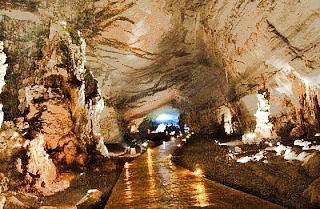
Cacahuamilpa cave

The sinkholes of the Yucatán Peninsula are beautiful, but are not all that deep. In the state of Tamaulipas, El Zacatón is a sinkhole that is considered the deepest water-filled sinkhole in the world.

In the early days of tourism in Mexico, the Cacahuamilpa Caverns near Taxco (Guerrero) were a popular place to visit. The English traveler Mrs. Alec Tweedie recalls in Mexico as I saw it how she was deep underground in these caves when a telegram arrived bearing the sad news that Queen Victoria had passed away. (If only postal and telegraph services were that efficient today!)

In recent years, scientists have begun to unravel the mysteries of how strange forms of life can thrive deep underground, even in environments that are noxious to humans. The sulfur-loving organisms of the Cueva de la Villa Luz in the state of Tabasco are a much-studied example.

Pint also discusses lava caves, of which Mexico has some fine examples. One of the most visited lava caves in the world must be that which plays home to the La Gruta restaurant, close to the famous archaeological site of Teotihuacan.

And, finally, for one of the most spectacular caves imaginable, how about the Naica crystal caves?

Visit John Pint’s website for a selection of his writing, with many original articles, illustrated with great photographs, about individual caves in Mexico.

Sadly, we did not have room in Geo-Mexico: the geography and dynamics of modern Mexico to delve beneath the surface into the wonders of Mexico’s caves.  Mexico’s landforms are discussed in chapter 3, which may be expanded in future editions, depending on the feedback from readers like you. If you have not yet read a copy, please ask your local library for a copy, or better yet, please consider purchaing your own copy via this website or amazon.com

Feedback from readers about any aspect of Geo-Mexico: the geography and dynamics of modern Mexico is welcomed.

Preserving the genetic diversity of corn in Mexico is essential for future world food security

 Mexico's geography in the Press  Comments Off on Preserving the genetic diversity of corn in Mexico is essential for future world food security
Sep 242010
 

Corn (maize) originated in Mexico, and has long been the staple subsistence crop among Mexico’s campesinos, as well as being one of the essential ingredients in Mexico’s varied cuisines, from tortillas to tamales, and pozole to enchiladas.

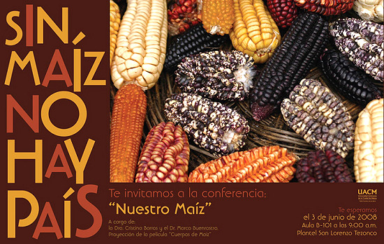
Corn poster

"Without corn there is no nation" (Poster from a 2008 conference at the Autonomous University of Chihuahua)

It was recently announced that Mexico’s federal Agriculture Secretariat is financing a germoplasm bank to preserve the genetic diversity of Mexico’s native varieties of corn. The facility is located in the Antonio Narro Autonomous University of Agriculture (UAAAN) in Saltillo (Coahuila), and will eventually house up to 100,000 samples of 60 distinct varieties of corn supplied by farmers  from all over the country. The first seeds have already been deposited in the germoplasm bank by farmers from the state of Puebla. The University plans to add an interactive museum of corn and a seed-production division at a later stage.

Helping to ensure that corn’s genetic diversity is preserved for future generations is an invaluable contribution towards future global food security.

Mexico’s corn-based cuisine, specifically that of the state of Michoacán, was recently accorded status by UNESCO as a vital part of the country’s Intangible Cultural Heritage.

Further reading:

Classic recipes related to corn (all from MexConnect’s astounding Mexican cuisine pages):

Our grateful acknowledgment to Cristina Potter of MexicoCooks! and MexConnect for bringing much of this material to our attention.

Build-it-yourself wind and solar power for rural Oaxaca

 Mexico's geography in the Press  Comments Off on Build-it-yourself wind and solar power for rural Oaxaca
Sep 212010
 

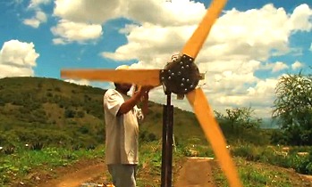
Many remote settlements in the mountains of Oaxaca are still not connected to the national electricity grid. A project based in the municipality of Ejutla (60 km south of Oaxaca City) aims to bring affordable renewable energy to isolated hamlets. The innovative scheme relies on a design for a power-producing wind-vane, complemented by a solar panel for when the wind fails to blow.

Wind power in Oaxaca

Wind power in Oaxaca (still from John Dixie's video)

Constructing the system does not require any specialist materials or equipment, but relies on readily available components. For example, the blades for the wind turbine are made of wood which means they are easy to repair and adjust as needed.

More information?

Mexico’s cultural diversity is discussed in chapters 10 and 13 of Geo-Mexico: the geography and dynamics of modern Mexico. Rural areas are the focus of chapter 24 and development indices of various kinds are discussed in chapters 29 and 30. Ask your local library to purchase a copy today!

April earthquake leads to Mexico-USA talks over water-sharing

 Mexico's geography in the Press  Comments Off on April earthquake leads to Mexico-USA talks over water-sharing
Sep 142010
 

In April 2010, a large earthquake rattled the Mexicali area, causing significant damage. It was so powerful that it even moved the southern part of California! The magnitude 7.2 earthquake damaged the irrigation infrastructure used by Mexican farmers on land along the lower Colorado River and in the Colorado River delta region.

Mexico and US officials are reported to be discussing the Colorado water-sharing agreement, given the damage done to irrigation facilities following the April earthquake (The OOSKA News Weekly Water Report for Latin America and the Caribbean, 18 August 2010).

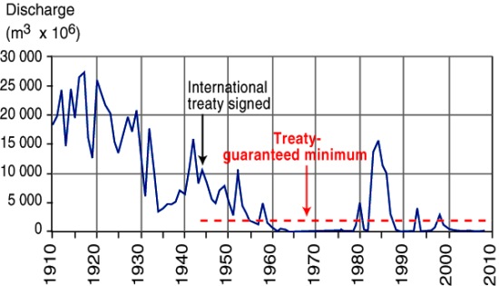
River Colorado discharge entering Mexico, 1910-2010

River Colorado discharge entering Mexico, 1910-2010. Figure 6.5 of Geo-Mexico; all rights reserved

As we noted in an earlier post, a 1944 treaty guaranteed that at least 1750 million cubic meters of water (see graph) would enter Mexico each year along the Colorado River via the Morelos diversionary dam in the Mexicali Valley. The damaged infrastructure means that Mexico is unable to use effectively all of its annual allocation of water from the Colorado. Urgent repairs are underway on pumps, pipelines and irrigation channels, particularly those in the Mexicali region.

Meanwhile, Mexican officials have asked their US counterparts if it is possible to store some of Mexico’s 2010 allocation of water in the Lake Mead reservoir near Las Vegas, until repairs to irrigation systems have been completed.

Earthquakes in Mexico are discussed in detail in chapter 2 of Geo-Mexico: the geography and dynamics of modern Mexico. Mexico’s water resources and water-related issues are the subject of chapters 6 and 7. Ask your library to buy a copy of this handy reference guide to all aspects of Mexico’s geography today! Better yet, order your own copy…

Sep 092010
 

In two previous posts, we examined the historical connections between Mexico and the Philippines.

A news story (on mb.com.ph) a few months ago alerted us to another, much more recent link between the two countries.

The Philippine Drug Enforcement Agency (PDEA) claims that a Mexican herb poses a significant public health risk. According to the PDEA, Salvia divinorum, which is hallucinogenic when sun-dried leaves are chewed, sniffed or smoked, has been found growing wild in the Teachers Village in Quezon City. The plant is a member of the mint family and has a distinctive square stem. It is not known how or when it was introduced into the Philippines.

It is endemic to the remote region of the Sierra Mazateca in the northern part of the state of Oaxaca, Mexico. The plant grows in the warm, damp tropical evergreen and cloud forests at elevations between 300 and 1800 meters (1000 to 6000 feet). Biologists remain uncertain whether the plant is a truly natural plant or whether it is actually a hybrid (a cross between two or more distinct plant species) or cultigen (a plant that has been deliberately altered or selected by humans). It is commonly known in Mexico as divine sage, and the local Mazatec indigenous group has a long tradition of employing the plant in spiritual healing ceremonies.

The active constituent of Salvia divinorum is known as salvinorin A. Wikipedia’s entry on divine sage claims that “By mass, salvinorin A is the most potent naturally-occurring psychoactive compound known.”

We are not sure why it is in the interests of the PDEA to offer helpful tips for anyone thinking of growing and using this particular plant, but a PDEA spokesperson did just that, describing the plant as being somewhat similar to cannabis (marijuana), but easier to grow, since it can be propagated via stem cuttings. In addition, “The addictive effect of the said plant will last long if the leaves of the plant will be spread on a person’s gums rather than sniffing or puffing it like a cigarette. They say it gives you an uncontrollable laugh trip because the user will see the people as if they were caricatures or cartoons.” At least the final part of that quote appears to be hearsay and probably not admissible if introduced into a courtroom!

Despite its known hallucinogenic qualities, the cultivation and possession of divine sage remain legal in almost every country around the world. In the USA, only certain states have criminalized the plant. Click here for a webpage which provides more details of divine sage’s legal situation in particular countries and US states.

In the Philippines, the PDEA is reported to be collecting further evidence prior to recommending whether or not owning the plant should be made illegal. Sounds like it could be a fun job if you can get it!

Divine sage is the latest link in the 450-year-long history of close connections between Mexico and the Philippines.

Mexico’s links with other countries are discussed in chapter 20 of Geo-Mexico: the geography and dynamics of modern Mexico. Ask your library to buy a copy of this handy reference guide to all aspects of Mexico’s geography today! Better yet, order your own copy…

Sep 072010
 

When complete, this dramatic new highway will have significant economic impact. Drivers using the old road report that it can take from five to nine hours to make the 325 kilometer trip, depending on traffic and one’s willingness to risk passing slow trucks on virtually blind curves. Buses allow 6.5 hours.

When completed, the driving time on the new four lane expressway will be reduced to less than three hours. Durango residents will easily be able to go off to the beach in Mazatlán for the week-end. The driving time from Monterrey or South Texas to Mazatlán will be reduced to less than a day. This could revive Mazatlán as a major tourist destination after a couple of decades of relative stagnation.

The port of Mazatlán

The port of Mazatlán. Photo: Stan Shebs (Wikimedia Commons)

Perhaps the biggest effect of the new highway will be the improved connection between the Pacific Ocean port of Mazatlán and north-central Mexico (population about 12 million) and most of Texas (about 20 million). The impact from increased trade in finished products (especially those which are relatively light and suitable for truck transport) will be significant.

Shrimp from Mazatlán and many, many products destined for northern Mexico/Texas from the Pacific Rim Region (China, South Korea, Taiwan, Japan, Indonesia, Australia, etc.) will be shipped through Mazatlán and trucked from there on the new highway. We expect there will be considerable trucking/shipping in the opposite direction as well. The resulting increased shipping through the port of Mazatlán will stimulate economic growth.  However, to facilitate these shipments, new urban expressways should be built through or around the cities of Durango, Torreón and Saltillo.

We expect the impact on the state of Durango will be less. Most of Durango’s mineral and timber products are rather bulky, not ideally suited to truck transport, and not globally competitive; therefore they will not find their way through Mazatlán to world markets.

Some (including Chris Hawley in USA Today) have argued that the new highway will have an appreciable impact on drug production and trade by improving police access and providing new economic opportunities. We think the impact will be rather slight. The Western Sierra Madre (Sierra Madre Occidental) covers about 200,000 square kilometers and the road affects less than 4% of this area (assuming an area of influence 25 kilometers wide either side of the highway). In our opinion, whatever illegal drugs are currently being cultivated in the Western Sierra Madre will continue to be grown. Yes, some people along the highway will find new employment in roadside commerce, but these jobs will be rather few.

Chapter 3 of Geo-Mexico: the geography and dynamics of modern Mexico discusses how the Sierra Madre Occidental influenced Mexico’s historical development. Chapter 17 analyzes the difficulties of transportation between Mazatlán and Durango. Buy your copy today to have a handy reference guide to all major aspects of Mexico’s geography!

The distinctive sounds of Mexico’s towns and cities

 Mexico's geography in the Press, Teaching ideas  Comments Off on The distinctive sounds of Mexico’s towns and cities
Aug 312010
 

Geographers have long been interested in the distinctive contribution of sounds to landscapes, especially urban landscapes. Some sounds are associated with pleasure, some with danger, others with impatience. The soundscapes of cities have become a legitimate area of study.

Early work tended to focus on traffic noise or on identifying areas where ambient noise from industry or other activities exceeded a comfortable threshold volume.

Soundscapes vary from rural areas to urban areas, and from one region to another. Mexico’s urban soundscapes are among the most distinctive on the planet, and this week has been declared National Sound Week by the federal government. Several “sound walks” have been organized in major cities.

As a USA Today article points out, all sounds contain a message. For example, “A series of four notes on a pan flute means the scissor-sharpening man is in the neighborhood. A ringing hand bell means the garbage truck is here” and so on.

The traffic whistles made by police are an important subset of the sounds in any Mexican town or city. They have a mini-language of their own, explored in this MexConnect article: Did you know? Different traffic whistles in Mexico mean different things.

Fieldwork idea: Portable sound meters make it relatively easy to compile a map showing the sound levels (measured in decibels) around particular sources of sound, whether periodic in occurrence (such as vehicles at a traffic light or the crowd in a sports stadium) or more or less continuous (like the hum of wind turbines or the noise of a factory).

Once a map has been compiled, analyze any patterns you can identify. Studies of urban soundscapes are not only of academic value, but have an important role in city planning as well. For example,

  • Do tall buildings mask the loudest sounds, or do they funnel it towards the listener?
  • Does the sound level vary depending on the quantity of vegetation between the sound source and the listener?
  • Which kinds of vegetation are most effective in masking sounds?
  • Is east-west traffic louder than north-south traffic?