The transformation of Chapala from fishing village to international tourist destination

 Other  Comments Off on The transformation of Chapala from fishing village to international tourist destination
Sep 032020
 

The town of Chapala, on the shores of Lake Chapala—Mexico’s largest natural lake—played an important role in the history of tourism in North America and has become one of the world’s premier retirement destinations. Yet, the details of how and why this transformation occurred have never been adequately reconstructed… until now!

Geo-Mexico is reader-supported. Purchases made via links on our site may, at no cost to you, earn us an affiliate commission. Learn more.

My latest book If Walls Could Talk: Chapala’s historic buildings and their former occupants, reveals the results of more than two decades of research. The book explores the history of the town’s formative years and shares the remarkable and revealing stories of its many historic buildings and their former residents.

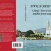
The front cover shows the waterfront of Chapala at the start of the twentieth century. On the right is the parish church of San Francisco, which dates back to the sixteenth century and features in D. H. Lawrence‘s novel The Plumed Serpent, set at the lake. (The house Lawrence rented in 1923 is now a boutique bed and breakfast.) The turreted tower on the left is part of the Villa Ana Victoria which was built by the Collignon family of Guadalajara in the 1890s, right at the start of the village’s explosive growth.

The illustration is a photograph by American photographer Winfield Scott that was colorized and published in about 1905 by Jakob Granat, a postcard publisher based in Mexico City.

In 1890, Chapala was a small fishing village. Within decades it became an important international tourist destination. This book explains how and why this transformation took place, and looks at the architects, entrepreneurs, adventurers and visionaries responsible. The cast of characters includes Mexican and British politicians and diplomats, as well as the eccentric Englishman Septimus Crowe, who abandoned his wife and child in Norway and carved out a new life for himself by investing in Mexican mines and importing a German-built yacht to sail the lake. Crowe was the area’s first real estate developer and pressured friends and acquaintances to join him in Chapala. One of the town’s central streets is named after him.

Chapala’s transformation into an international tourist destination was aided by its links to dictatorial President Porfirio Díaz, whose wife’s relatives lived on the outskirts of the town, and by a host of business leaders and wealthy, high society families from Mexico City and Guadalajara.

The story of Chapala is truly international. The visionary Norwegian entrepreneur Christian Schjetnan refused to take no for an answer as he worked tirelessly to organize a Chapala Development Company, start a yacht club, run steamboats on the lake, and build a branch railroad linking Chapala to the Central Mexican Railroad mainline at La Capilla, near Atequiza.

Chapala’s first major hotel, the Hotel Arzapalo which opened in 1898, was built by a Mexican businessmen and had a succession of Italian managers, some more honest than others. Many members of the extensive French and German communities in Guadalajara also played key roles in the area, both by building private family villas in Chapala and by helping finance improvements and public buildings in the town.

Organized as a walking tour of Chapala, each of the 42 chapters of If Walls Could Talk focuses on a different building and explores the fascinating stories of its former occupants—locals and foreigners. The valuable legacy left by these extraordinary individuals is still clearly visible today in the streets, villas, hotels and grand mansions of this idyllic lakeside locale.

The book includes more than 40 vintage photographs and four original maps showing how Chapala’s street plan has changed over the years. The text is supported by a bibliography, index and detailed reference notes.

Sep 262016
 

Lake Chapala is Mexico’s largest natural lake. On the geological timescale of millions of years, all lakes are temporary features on the earth’s surface. Once formed, natural processes begin to fill them in and/or to drain them.

Map of Lake Chapala, Jalisco, Mexico. All rights reserved.

Lake Chapala resulted from drastic earth movements, accompanied by earthquakes and faulting which occurred some twelve million years ago. Lake Chapala collected on the floor of a rift valley. Movements along the parallel systems of faults that caused the rift valley still occur today. Evidence for this continued movement can be seen in the cracked or displaced walls of some local buildings.

Given its advanced age, it is not surprising to discover that Lake Chapala was once (thousands of years ago) much larger. In fact, though no-one has so far proven it beyond doubt, it may have been immensely large, covering an area seven times its present area, with a correspondingly long shoreline. At a later stage in its history, it became the deepest lake of an interconnected series of lakes which flooded the valley floors where the towns of Jocotepec, Zapotitan, Zacoalco and Sayula are today. The present Lake Chapala is thus probably only a small remnant of the original version.

The lake is under heavier pressure than at any time in its existence. Local towns and the nearby city of Guadalajara see it as an inexhaustible supply of domestic and industrial water. Tourists see it as a recreation resource, and the thousands of foreign retirees who have settled on its shores see it as a major reason for the area’s beneficial climate.

A case study of ‘residential tourism’ in the villages on the northern shore of Lake Chapala is discussed in chapter19 of Geo-Mexico: the geography and dynamics of modern Mexico.

The levels of flow of the River Lerma, the only river of any size entering the lake, are crucial to the health of the lake. In recent years, demands for Lerma water have multiplied many times over, principally for farms in neighboring states, but also for industries. All the other rivers entering the lake are much smaller and, with rare exception, flow into the lake only a few times a year during the rainy season. The hydrology of Lake Chapala is discussed in chapters 6 and 7 of Geo-Mexico: the geography and dynamics of modern Mexico.

The good news is that Lake Chapala was recently declared an Internationally Important Wetland by the Ramsar Convention, joining a large global network of similarly important wetland sites. The 13th International Living Lakes Conference was held in Chapala, March 22-25, 2010.

This is an edited excerpt from Tony Burton’s Western Mexico, A Traveller’s Treasury (4th edition) .

Apr 282016
 

Like most geographers, I collect maps and information wherever I travel; you never know what surprises await. Tourism publications are especially interesting since they are specifically designed (one assumes) to show the best side of the places described.

My collection of tourist brochures associated with Jalisco and the Lake Chapala area dates back more than thirty years. Many early versions had stylized maps, drawn by graphic designers, not cartographers, with sound (if uninspiring) text in Spanish. English translations were often unintelligible. In the 1980s, several bilingual members of the now-defunct Association of Travel Reporters, based in Guadalajara, offered to help the Jalisco State Tourism Department improve its translations, but the offer was politely declined.

chapala-brochure-2016

As this latest brochure relating to Lake Chapala shows, translation standards have not improved significantly since then, and remain a long way off “native speaker” level. This is particularly unfortunate, given that this area of Mexico has the largest concentration of English-speakers in the country.

Here, for example, is the English translation of the attractions of San Juan Cosalá:

One has to closely experience San Juan Cosalá in order to feel and enjoy it to the most, so come and discover a place you will never want to leave, for every happy moment can be lived here, as just by visiting you feel enveloped in an affluent of joy and vitality.

In getting to know it, just stroll across its Pier, or admire the harmonious architecture in San Juan Evangelista Church, or enjoy the exquisite aromas of seafood, bouncing from restaurants enlivened with fine music while walking over the Piedra Barrenada (Drilled Stone); or the rest;  freshness and fun offered in thermal waterparks and world level spas.

Undated tourism brochure, collected April 2016

Undated tourism brochure, collected April 2016

The cartography (above) also leaves a lot to be desired. A key (not shown in this post) is provided but the Jalisco Tourism department clearly needs to hire a geographer if they want to publish useful and meaningful maps. Details worth noting include:

  • No symbol in the key for the “gas station” signs shown on the map. The map shows only four gas stations in this area (and none in Chapala or Ajijic); there are dozens of others not shown on the map, including several in Chapala and Ajijic.
  • The map has no scale.
  • The Isla de los Alacranes, a short boat-ride from Chapala, is shown a long way south of its true position, and a lot further from Chapala than it really is.
  • The dark blue area is, according to the key, the Chapala Lakeshore. I have absolutely no idea what it really represents! Lake Chapala’s catchment area is a completely different shape to the dark blue area. The “Chapala Lakeshore” should, obviously, also include the south-east section of the lake around Las Palmas and Cojumatlán. Much of the area colored dark blue is out of view of the lake, and drains towards the Santiago River, not the lake.
  • Placing the word “CHAPALA” in the north-east section of the dark blue area is totally misleading. The area where the word is written is NOT in the lake basin, not in view of the lake, and is not even in the municipality of Chapala. Again, I have no idea why the artist responsible for this map chose to ignore geography.

It is 2016, and Jalisco State tourism officials still need to improve the quality of their brochures and maps. Come on guys! Time to up your game!

Will UNESCO give World Heritage status to Lake Chapala?

 Books and resources, Other  Comments Off on Will UNESCO give World Heritage status to Lake Chapala?
Sep 072015
 

We don’t often champion causes in these pages, but are more than willing to lend our support to a campaign hoping to persuade UNESCO to declare Lake Chapala a “World Heritage” site. The campaign appears to have stalled, and deserves more support.

The following 6-minute video (English subtitles) from 2008 sets the scene for those unfamiliar with the area:

Where is Lake Chapala?

Map of Lake Chapala

Map of Lake Chapala. Credit: Tony Burton; all rights reserved.

Why should Lake Chapala be declared a World Heritage site?

Natural history: it is Mexico’s largest natural lake and home to some unique endemic fauna.

Cultural and historic significance: it is a sacred site for the indigenous Huichol Indian people. Specifically, the southernmost “cardinal point” in their cosmology is XapaWiyemeta, which is Scorpion Island (Isla de los Alacranes) in Lake Chapala.

In the nineteenth century, as Mexico fought for its independence from Spain, Lake Chapala was the scene of a truly heroic struggle, centered on Mezcala Island, between the Royalist forces and a determined group of insurgents. It proved to be a landmark event, since after four years of fighting, an honorable truce was agreed.

At the very end of the nineteenth century, influential families from Mexico and from overseas “discovered” Lake Chapala. For several years, Mexico’s then president, Porfirio Díaz, made annual trips to vacation at the lake. As the twentieth century progressed, the area attracted increasing numbers of authors, poets and artists, many of them from abroad, including such greats as D.H. Lawrence, Tennessee Williams, Witter Bynner, Charles Pollock and Sylvia Fein. (To discover more of the literary and artistic characters associated with Lake Chapala, please see this on-going series of mini-biographies.)

Today, it is the single largest retirement community of Americans anywhere outside of the USA.

Is this enough to qualify Lake Chapala for World Heritage status? I don’t know, but it certainly seems worth a shot!

Posts related to Lake Chapala:

Tourism in the Lake Chapala (Ajijic, Chapala, Jocotepec) and the Lerma-Chapala basin:

Want to read more?

For general introduction and background to this area, see the first eight chapters of my Western Mexico: A Traveler’s Treasury (4th ed, 2013). In the words of Dale Palfrey, reviewing the book for the Guadalajara Reporter, “First published in 1993, the revised and expanded fourth edition of “Western Mexico”… opens with what qualifies as the most comprehensive guide to the Lake Chapala region available in English.“

For a more in-depth account of the history of the Lake Chapala region up to 1910, see my Lake Chapala Through the Ages, an anthology of travelers’ tales. It features informative extracts from more than fifty original sources, linked by explanatory text and comments, together with brief biographies of the writers of each extract. They include some truly fascinating characters… see for yourself!

Both books are available as regular print books, or in Kindle and Kobo editions.

How can tourism perception be assessed? A case study using the Lerma-Chapala drainage basin

 Books and resources, Teaching ideas  Comments Off on How can tourism perception be assessed? A case study using the Lerma-Chapala drainage basin
Aug 282014
 

In numerous previous posts, we have looked at the importance of tourism in Mexico, and have examined its impacts at different scales, from the national/international scale at one extreme to the single resort scale at the other:

National scale:

Sub-national regional scale:

Single resort scale

We have also considered the way in which the characteristics of tourism in a resort change over time:

Attempting to quantify the importance or impacts of tourism, beneficial or otherwise, is fraught with methodological difficulties. The number of hotel rooms in different cities is often used as a proxy measure of the relative importance of tourism in different communities, but looking only at tourist capacity “masks  the fact that hotels are rarely full. In 2007, the national occupancy rate was 54.8%. Traditional beach resorts such as Acapulco, Mazatlán and Puerto Vallarta had an occupancy rate of 52.2%, compared to 68.1% for modern, planned mega-resorts like Cancún and Los Cabos. The occupancy rate in the large cities—Guadalajara, Mexico City and Monterrey—was 55.0%, well ahead of the 47.2% for other interior cities.” (Geo-Mexico, p 134).

As in other branches of geography, it is not only the “reality” that matters, but also people’s perceptions of reality. Most decisions concerning location (such as where to live, the best place to start a new business. etc) are taken on imperfect or incomplete information; in other words, these decisions are based, at least to some extent, on perceptions.

In the case of tourism, it is the perception of visitors that matters. This is precisely why certain resorts gain a reputation as being “jet set” or the “in place” to vacation. The “in place” today is not going to be the “in place” in a few year’s time, since perceptions (and reality) change. Nowhere has this proved to be more true in Mexico than in the case of Acapulco.

But is it possible to measure tourist perceptions? It is very difficult to do so directly, but there are ways of tackling this question, and here we look at one approach, based on an analysis of tourist-oriented literature.

The approach is easiest to explain in the context of a real example, in this case an analysis of the likely perception of foreign tourists of destinations in the Lerma-Chapala drainage basin in Mexico. (This study formed part of my contribution on tourism to the Atlas de la cuenca Lerma-Chapala, construyendo una visión conjunta, Semarnat-Unam-IE, 2006 – the link is to a low-resolution pdf of the entire atlas).

The Lerma-Chapala Basin (see map) is one of Mexico’s major river systems, comprising portions of 127 municipalities in five states: México, Querétaro, Michoacán, Guanajuato and Jalisco. The basin has considerable economic importance. It occupies only 2.9% of Mexico’s total landmass, but is home to 9.3% of Mexico’s total population, and its economic activities account for 11.5% of national GDP. It also has considerable importance for tourism.

Lerma Basin Tourist Perception Index.

Lerma Basin Tourist Perception Index. Cartography: Tony Burton / Geo-Mexico; all rights reserved Click to enlarge.

The red circles superimposed on the map represent an index of tourism perception. This index is based on an analysis of seven tourist guides that purport to cover the entire country:

  • AAA Tourbook (2004)
  • Let’s Go Mexico (2004)
  • Lonely Planet (2002)
  • Footprint Guide (1999)
  • Upclose Mexico (1998)
  • Insight Guide (1994)
  • Cadogan Guide (1991)

In each case, the total number of lines of text in the guide devoted to any location within the Lerma-Chapala drainage basin was counted, as well as the number of lines devoted to each individual location. This allowed a ratio or percentage to be worked out for each place for each book. For example, if a book had 240 lines in total devoted to the drainage basin, of which 60 were devoted to San Miguel de Allende, the perception index for San Miguel for that book would be 60/240 * 100 = 25%. Similar calculations were performed for all the locations mentioned, for each book, and then the mean index was calculated for each location. These mean indices were the basis for the size of the circles on the map.

In broad terms, the map shows which places are likely to be on a foreign traveler’s radar when they are visiting the area. Those familiar with this area may be surprised to see that the ghost town of Pozos merits as many lines of text as Quiroga (and indeed more lines of text than Atotonilco). Another surprise is that Tzintzuntzan appears to be as much in the tourist eye as Chapala, Dolores Hidalgo or Toluca. The main purpose of this post is not to analyse such apparent anomalies but only to suggest a relatively easy way of analysing tourist perceptions through the use of tourist-oriented literature. Applying the same method to the entire country, on a state-by-state basis, throws up far more interesting anomalies which we plan to share at some point in the future.

Related posts:

Related posts:

Aug 162014
 

Tourism associated with rivers and lakes

So far as tourism is concerned, Lake Chapala is far more important than the other bodies of water within the basin. Only limited recreational activities are practiced in the various man-made reservoirs and in lakes Yuriria and Cuitzeo. Tourism is locally important in Zirahuén the most pristine of the basins lakes, but its small area restricts development prospects. Tourism, including ecotourism, is also locally important in Lake Pátzcuaro, with pronounced seasonal peaks corresponding to school vacations and the annual Night of the Dead. Surprisingly, there are no specialized ecotourism services at Lake Chapala.

Lerma-Chapala Basin

Lerma-Chapala Basin. Cartography: Tony Burton/Geo-Mexico; all rights reserved

The map shows areas of soil degradation in the Lerma-Chapala basin, as well as the locations where agriculture is a major source of water contamination. The environmental impacts of tourism in the basin are concentrated in the major cities such as Guanajuato, San Miguel de Allende and León, as well as in the smaller communities where tourism is of particular importance, such as Chapala and Pátzcuaro.

The lakes in the basin, especially Chapala, have always had more significance than the rivers for recreation and tourism activities. In the nineteenth century, sail canoes plied the waters of Lake Chapala. Fluctuating lake levels since the 1950s have prevented any concerted effort to establish modern water sports (yachting, water-skiing, windsurfing) on the lake, though casual users can be seen sporadically, mainly at weekends and during school holidays. Recreational fishing is virtually non-existent in the basin. Boatmen and fishermen often have conflicting demands.

Potential for ecotourism

Environmental degradation throughout the basin has reduced the number of potential ecotourism locations. The few remaining natural habitats are in urgent need of effective conservation. None of the few small areas of the basin currently protected at a federal level is associated directly with the River Lerma or Lake Chapala. Several tourism hot spots are under extreme pressure, operating at close to carrying capacity (defined as the maximum number of visitors they can handle without adverse environmental impacts). They include the Monarch butterfly reserves, Lake Camécuaro National Park, and the island of Janitzio in Lake Pátzcuaro. Well managed tourism could help finance habitat restoration and protection. Successful planning will require considerable local participation.

Lovers of flora and fauna want to see native and endemic species, rather than imported exotics. Bird-watching is one of the fastest growing recreational activities in the U.S., a huge niche tourism market in a wildlife watching industry worth 10 billion dollars in North America (Stap, 2002). In the basin, bird-watchers have the opportunity to see several endemics, as well as spectacular flocks of the White Pelican (Pelecanus erythrorhynchos), which can be better viewed on the relatively undeveloped southern shore of Lake Chapala than in its breeding grounds far to the north.

The development of horse-back riding, hiking and walking trails holds considerable potential for the future. Niche markets, such as cultural, shopping and eco-tours could all be further developed. Most tourists prefer a mix of experiences; the basin offers numerous, varied tourism possibilities.

Historically, hunting was an important activity in certain areas, particularly in the marshes at the eastern end of Lake Chapala (the ciénega). One ecological issue here, aside from any need to manage wildlife numbers, is the gradual decomposition of the lead-rich cartridges used a century ago. While this needs further study, this is gradually leaching lead into the environment, but is not the only source of the elevated levels of lead that have been reported in fish and lirio samples (Jay & Ford in Hansen & Van Afferden, 127). Careful monitoring is needed to ensure that no health risk is posed to humans.

Tourism exacerbates existing demands for limited supplies of water. This needs to be recognized in tourist-oriented cities such as San Miguel de Allende, Guanajuato and Pátzcuaro. Some recreational and tourism developments are more water demanding than others. Large expanses of grass cause high losses of water through evapo-transpiration especially during the dry season when watering is needed if grass is to be kept green. However, in the rainy season, grass promotes higher infiltration rates, enhancing groundwater recharge. Pressure from public and private gardens for water could be significantly reduced by xeriscaping.

Management is also needed to ensure that chemicals used in gardens, hotel grounds, and hotels do not cause pollution. The misuse of fertilizers and pesticides can have serious deleterious environmental effects. Overfertilization, for example, can increase nitrogen and phosphorus loads on watercourses, promoting eutrophication.

Golf can be one of the least environmentally sound of all recreational activities (Elkington & Hailes 1992). Constructing a golf course may involve habitat destruction and loss of wildlife; its maintenance may require copious quantities of water and agro-chemicals. A single course may use 330,000 cubic meters of water a year, as much as 4,500 people (Walsh, 2004) Aside from the ethical issue of whether water should be allocated to the playgrounds of the rich while the poor go without, golf courses can greatly reduce water consumption with careful design and management. Of Mexico’s 200+ golf courses, at least 23 are located in the basin. Several were built in the past twenty years. Several others are still in the planning stages. More golf courses may attract more retirees and tourists, but decision makers need to consider the possible social and environmental effects of constructing more courses.

References:

  • Hansen, Anne M. & van Afferden, Manfred (ed). The Lerma-Lake Chapala Watershed: Evaluation and Management. New York: Kluwer Academic / Plenum Publishers. 2001.
  • Elkington, John & Julia Hailes. Holidays that don’t cost the earth. The guide to greener holidays. London: Victor Gollancz Ltd. 1992.
  • Stap, Don. “Great Florida Birding Trail” in Audubon Magazine September, 2002.
  • Walsh, J. “War over water”. Golf Course News, October 2004. G.I.Media. 2004

Source:

This post is based on my contribution (on tourism) to the Atlas de la cuenca Lerma-Chapala, construyendo una visión conjunta, published by Semarnat-UNAM-IE, Mexico, in 2006. (The link is to a low-resolution pdf of the entire atlas).

Related posts:

Day trips and tourism in the Lerma-Chapala basin

 Other  Comments Off on Day trips and tourism in the Lerma-Chapala basin
Aug 072014
 

An earlier post looked at the significant impacts of the estimated 10,000 to 15,000 residential tourists (non-working, non-Mexicans) living part or full-time in the Lerma-Chapala basin. These residential tourists are concentrated in San Miguel de Allende and in the Chapala-Ajijic area on Lake Chapala:

Day trips and regular tourism are also important activities in the Lerma-Chapala basin. Both day trippers and tourists bring economic, social, cultural and environmental benefits, but may also create adverse impacts. Conflicts between tourism and other activities are increasing as demographic and environmental pressures rise.

Day trips

By definition, day trips last less than 24 hours. Most day trips are to a single destination, usually only a relatively short distance from home. Within the Lerma-Chapala basin, certain day trip flows stand out. The strong flow of day-trippers from Guadalajara to Chapala-Ajijic peaks on Saturdays, Sundays and public holidays. Day trippers account for about two-thirds of the total number of visitors to Chapala-Ajijic. Day trip flows linking San Miguel de Allende, Dolores Hidalgo and Guanajuato, and between Morelia and Pátzcuaro are also important. Elsewhere, the Monarch butterfly reserves have seasonal importance as day trip destinations; for example, El Rosario, the most visited reserve, attracts up to 5,000 visitors a day between early December and late March.

Tourism

Tourism, on the other hand, involves overnight stays. A typical tourist trip lasts between 3 and 8 days. Tourism may involve multiple destinations, further away from home. In Mexico, national tourists are more numerous, but, on average, earn less, spend less, and stay a shorter time, than international tourists.

In the Lerma-Chapala basin, tourism began to flourish at the end of the nineteenth century, alongside improvements in transportation, especially the building of railways. The shores of Lake Chapala were an early magnet for the wealthy. Developers redesigned the unplanned fishing villages, attracting visitors from all over Mexico. Even today, the Chapala landscape reflects the historical and cultural influences which have influenced it.

Other parts of the basin also became important tourist destinations. The colonial cities route, taking in San Miguel de Allende, Guanajuato, Morelia, Pátzcuaro and Querétaro, is a prime example, which has been very successfully marketed.

Quantifying tourism in the basin is difficult. Official tourism statistics are based on surveys, but these data have their limitations. The size of the circles on the map below represents the total number of tourists visiting each location in 2005, according to Tourism Secretariat figures. The yellow segment represents the percentage of tourists that are international. atlas-tourist-numbers-2The map shows that tourism is heavily concentrated at a small number of locations close to the boundary of the basin: Morelia, Toluca, Querétaro, San Miguel de Allende, Guanajuato and Chapala-Ajijic. Foreign tourists are particularly important in Toluca, San Miguel de Allende and Chapala-Ajijic. The precise numbers should be treated with caution. Many tourists visiting San Miguel and Chapala-Ajijic (but not Toluca) do not stay in hotels but in “Bed and Breakfasts” or with friends or relatives.

Tourism planning needs to consider strategies which:

  • preserve existing and potential natural attractions and historic sites.
  • increase the number and variety of locations visited by tourists.
  • reduce the pronounced seasonality of existing tourism.
  • increase the average length of stay and expenditure of tourists.

Source:

This post is based on my contribution (on tourism) to the Atlas de la cuenca Lerma-Chapala, construyendo una visión conjunta, published by Semarnat-UNAM-IE, Mexico, in 2006. (The link is to a low-resolution pdf of the entire atlas).

Related posts:

Retirees and “residential tourism”: a case study of Chapala-Ajijic in Jalisco

 Excerpts from Geo-Mexico  Comments Off on Retirees and “residential tourism”: a case study of Chapala-Ajijic in Jalisco
Jan 162014
 

Retirees, mainly from the USA and Canada, form a special subgroup of tourists. About 1 million US visitors to Mexico each year are over the age of 60. Their total expenditure is about $500 million a year. Three-quarters arrive by air; half of these stay 4-8 days and almost one in ten stays 30 days or longer. Half stay in hotels, and one-third in time-shares; the remainder either stay with family or friends, or own their own second home. Of the 25% arriving by land, almost one in three stays 30 days or more. For Canadians, the patterns are broadly similar except that a higher percentage arrive by air.

The number of retiree tourists is relatively easy to quantify. However, it is extremely difficult to place accurate figures on the number of non-working, non-Mexicans who have chosen to relocate full-time to Mexico. Technically, these “residential tourists” are not really tourists at all but longer-term migrants holding residency visas. They form a very distinct group in several Mexican towns and cities, with lifestyle needs and spending patterns that are very different from those of tourists. Their additional economic impact is believed to exceed $500 million a year.

Map of Lake Chapala, Jalisco, Mexico

Map of Lake Chapala, Jalisco, Mexico. Credit: Tony Burton; all rights reserved.

The largest single US retirement community outside the USA is the Guadalajara-Chapala region in Jalisco, according to state officials (see map). The metropolitan area of Guadalajara, Mexico’s second city, has a population of about 4 million. The villages of Chapala and Ajijic (combined population about 40,000) sit on the north shore of Lake Chapala some 50 km (30 mi) to the south. Historically, Chapala was the first lakeshore settlement to attract foreign settlers, as early as the start of the 20th century. Today the area is home to a mix of foreign artists, intellectuals, escapees (of various non-judicial kinds), pensioners and ex-servicemen. In the last 40 years, Ajijic has become the focal point of the sizable non-Mexican community living on the lakeshore. Depending on how they are defined, there are probably between 6000 and 10,000 foreign residents in the Chapala-Ajijic area, the higher number reflecting the peak winter season. About 60% of retirees in the area own their own homes or condos, though many still own property in the USA or Canada as well, and many make regular trips north of the border.

The main pull factors for residential tourists are an amenable climate; reasonable property prices; access to stores, restaurants and high quality medical service; an attractive natural environment; a diversity of social activities; proximity to airports; tax advantages, and relatively inexpensive living costs.

David Truly has suggested that conventional tourist typologies do not work well with Ajijic retirees. He identified migrant clusters with similar likes and dislikes. Retirees vary in education, travel experience and how they make decisions about relocation. Early migrants tended to dislike the USA and Canada and adapted to life in Mexico. They were generally content with anonymity unlike many more recent migrants. Traditional migrants appreciate all three countries, but have chosen Mexico as their place of permanent residence. Many new migrants do not especially like the USA or Canada but are not particularly interested in Mexico either. They seek familiar pastimes and social settings and are content to have relatively little interaction with Mexicans.

The large influx of residential tourists into small lakeside communities like Ajijic inevitably generates a range of reactions among the local populace. From empirical studies of regular tourism elsewhere, George Doxey developed an “irritation index” describing how the attitudes of host communities change as tourist numbers increase. His model applies equally well to residential tourists. In the initial stage the host community experiences euphoria (all visitors are welcome, no special planning occurs). As numbers increase, host attitudes change to apathy (visitors are taken for granted) and then annoyance (misgivings about tourism are expressed, carrying capacities are exceeded, additional infrastructure is planned). If numbers continue to grow, hosts may reach the stage of antagonism, where irritations are openly expressed and incomers are perceived as the cause of significant problems.

Residential tourism in the Chapala-Ajijic area has certainly wrought great changes on the landscape. Residential tourists have created a distinct cultural landscape in terms of architectural styles, street architecture and the functions of settlements. (Browse the Chapala Multiple Listing Service New Properties). Gated communities have been tacked on to the original villages. Subdivisions, two around golf courses, have sprawled up the hillsides. Swimming pools are common. Much of the signage is in English. Even the central plazas have been remodeled to reflect foreign tastes. Traditional village homes have been gentrified, some in an alien “New Mexico” style.

On the plus side, many retirees, as a substitute for the family they left behind, engage in philanthropic activities, with a particular focus on children and the elderly. Retiree expenditures also boost the local economy. Areas benefiting from retirees include medical, legal and personal services, real estate, supermarkets, restaurants, gardening and housecleaning. Employment is boosted, both directly and indirectly, which improves average local living standards.

On the minus side, decades of land speculation have had a dramatic impact on local society. Land and property prices have risen dramatically. Many local people have become landless domestic servants, gardeners and shop-keepers with a sense that the area is no longer theirs. Crime levels have risen and some local traditions have suffered. The abuse of water supplies has resulted in declining well levels. Over zealous applications of fertilizers and pesticides have contaminated local water sources.

Other locations besides Chapala-Ajijic where a similar influence of non-Mexican retirees on the landscape can be observed include San Miguel de Allende (Guanajuato), Cuernavaca (Morelos), Mazatlán (Sinaloa), Puerto Peñasco (Sonara), Rosarito (Baja California) and Todos Santos (Baja California Sur). The most preferred locations are all on the Pacific coast side of Mexico.

As more baby-boomers reach retirement age, residential tourism offers many Mexican towns and cities a way of overcoming the seasonality of conventional tourism. Lesser-developed regions have an opportunity to cash in on their cultural and natural heritage and improve their basic infrastructure.

This is a lightly edited excerpt from chapter 19 of Geo-Mexico: the geography and dynamics of modern Mexico.

References:

  • Boehm S., B. 2001 El Lago de Chapala: su Ribera Norte. Un ensayo de lectura del paisaje cultural. 2001. Relaciones 85, Invierno, 2001. Vol XXII: 58-83.
  • Burton, T. 2008 Lake Chapala Through the Ages, an Anthology of Travellers’ Tales. Canada: Sombrero Books.
  • Doxey G.V. 1975 A causation theory of visitor‑resident irritants: methodology and research inferences. Proceedings of the Travel Research Association, San Diego, California, USA: 195‑8.
  • Stokes, E.M. 1981 La Colonia Extranero: An American retirement Community in Ajijic, Mexico. PhD dissertation, University of New York, Stony Brook, cited in Truly, D. 2002.
  • Truly, D. 2002 International Retirement migration and tourism along the Lake Chapala Riviera: developing a matrix of retirement migration behavior. Tourism Geographies. Vol 4 # 3, 2002: 261-281.
  • Truly, D. 2006 The Lake Chapala Riviera: The evolution of a not so American foreign community, in Bloom, N.D. (ed) 2006 Adventures into Mexico: American Tourism beyond the Border. Rowman & Littlefield: 167-190

Related posts:

Water management progress in the Lerma-Chapala basin

 Books and resources  Comments Off on Water management progress in the Lerma-Chapala basin
Jan 112014
 

The Lerma-Chapala Basin (see map) is one of Mexico’s major river systems, comprising portions of 127 municipalities in five states: México, Querétaro, Michoacán, Guanajuato and Jalisco.

The basin has considerable economic importance. It occupies only 2.9% of Mexico’s total landmass, but is home to 9.3% of Mexico’s total population, and its economic activities account for 11.5% of national GDP. The basin’s GDP (about 80 billion dollars/year) is higher than the GDP of many countries, including Guatemala, Costa Rica, Honduras, Paraguay, Bolivia, Uruguay, Croatia, Jordan, North Korea and Slovenia.

Lerma-Chapala Basin

The Lerma-Chapala Basin. Click map to enlarge. Credit: Tony Burton / Geo-Mexico

Given this level of economic activity, it is probably not surprising that the pressures on natural resources in the basin, especially water, are enormous. Historically, the downstream consequence of the Lerma Basin’s agricultural and industrial success has been an inadequate supply of (heavily polluted) water to Lake Chapala.

Following decades of political inactivity or ineffectiveness in managing the basin’s water resources, solid progress finally appears to have been made. Part of the problem previously was a distinct lack of hard information about this region at the river basin scale. The statistics for such key elements as water usage, number of wells, replenishment rates, etc. were all (to put it politely) contested.

Fortunately, several scientific publications in recent years have redressed the balance, and the Lerma-Chapala Basin is now probably the best documented river basin in Mexico. This has allowed state and federal governments to negotiate a series of management agreements that are showing some positive signs of success.

The first of these key publications was “The Lerma-Chapala Watershed: Evaluation and Management“, edited by Anne M. Hansen and Manfred van Afferden (Klewer Academic/Plenum Publishers, 2001). This collection of articles featured contributions from researchers in several universities and research centers, including the University of Guadalajara, Mexican Institute of Water Technology, Autonomous University of Guadalajara, Baylor University, the Harvard School of Public Health and Environment Canada. Click here for my comprehensive description and review of this volume on MexConnect.com.

Perhaps the single most important publication was the Atlas de la cuenca Lerma-Chapala, construyendo una visión conjunta in 2006. Cotler Ávalos, Helena; Marisa Mazari Hiriart y José de Anda Sánchez (eds.), SEMARNATINE-UNAM-IE, México, 2006, 196 pages. (The link is to a low-resolution pdf of the entire atlas). The atlas’s 196 pages showcase specially-commissioned maps of climate, soils, vegetation, land use, urban growth, water quality,  and a myriad of other topics.

More recently, a Case Study of the Lerma-Chapala river basin: : A fruitful sustainable water management experience was prepared in 2012 for the 4th UN World Water Development Report “Managing water under uncertainty and risk”. This detailed case study should prove to be especially useful in high school and university classes.

The Case Study provides a solid background to the Lerma-Chapala basin, including development indicators, followed by a history of attempts to provide a structural framework for its management.

In the words of its authors, “The Lerma Chapala Case Study is a story of how the rapid economic and demographic growth of post-Second World War Mexico, a period known as the “Mexican Miracle”, turned into a shambles when water resources and sustainable balances were lost, leading to pressure on water resources and their management, including water allocation conflicts and social turbulence.”

On a positive note, the study describes how meticulous study of the main interactions between water and other key development elements such as economic activity and social structures, enabled a thorough assessment on how to drive change in a manner largely accepted by the key stakeholders.

The early results are “stimulating”. “Drawbacks and obstacles are formidable. The main yields are water treatment and allocation, finances, public awareness, participation and involvement. The main obstacles are centralization, turbid interests, weak capacity building, fragile water knowledge; continuity; financial constraints; and weak planning.”

Sustainable water usage is still a long way off. As the Case Study cautions, “There is still much to do, considering the system Lerma-Chapala responds directly to a hydrologic system where joint action and especially abundant involvement of informed users is required, to achieve sustainable use of water resource.”

One minor caveat is that the Case Study does not offer full bibliographic reference for all of the maps it uses, which include several from the previously-described Atlas de la cuenca Lerma-Chapala, construyendo una visión conjunta.

Related posts:

How big is Lake Chapala?

 Other  Comments Off on How big is Lake Chapala?
Jun 012010
 

“How big is Lake Chapala?”

There is no single answer to this question.  It all depends on the reference point in time.

The extent of the former Lake Jalisco (click image to enlarge map)

Some geologists suggest that 40,000 years ago, the Lake’s surface area was seven times its current size and its volume about 200 times greater.  At that time, the Lake towered almost 700 feet above what is now Guadalajara and stretched nearly to Aguascalientes (see map).  The decline of this massive ancient lake resulted from sedimentation, tectonic faulting and the cutting of a fantastic drainage gorge by the Rio Santiago  (see Jack Leyden’s “The geology and geography of Lake Chapala and western Mexico”, on MexConnect.com)

In recent history, the size of the Lake has continued to change dramatically.  In the 19th century, the Lake stretched almost 20 kilometers farther east.  Construction of an 80 kilometer dike and drainage system in 1908 attempted to capture a large portion of the lake for agricultural use.  Through a series of successive floods, partially attributed to the Poncitlán Dam on the Rio Santiago, the lake recaptured the land.  However, the dikes were re-constructed and the land eventually converted to permanent farmland, only occasionally disrupted by flooding.  Environmentalists argue that this has destroyed an important ecological role of this once important marshland.

The size of Lake Chapala has fluctuated significantly in recent decades; from extreme lows in 1954-56, 1992 and 2003 to highs in the 1960-70s and 2005-06.  These dramatic low to high changes can increase the Lake level by 8 meters, its volume by a whopping 800% and its surface area by 100%.   Fortunately, the Lake is at a relatively high level as we approach the 2010 rainy season.

Obviously, answering the question, “How big is Lake Chapala?” is very time sensitive.   In November 2009, Lake Chapala was about 75 by 25 kilometers with a surface area of 1150 square kilometers and a volume of 5.5 billion cubic meters (bcm).

Lake Chapala is sometimes called the largest lake in Mexico, but even this can be questioned.  It is the largest in terms of surface area. But with its shallow depth it is not the largest in terms of volume. The amount of water it holds, even when full to maximum capacity, is only 8.1 bcm.  It trails three reservoirs behind hydroelectric dams: La Angostura (10.7 bcm), Malpaso (9.6 bcm) and Infiernillo (9.3 bcm). But we must remember that the volume of all Mexico’s lakes and reservoirs varies enormously from season to season and year to year.

What about the future?  All lakes are destined to disappear because they all eventually fill completely with sediment.  In the not too distant geologic future, Lake Chapala will be gone.  Speaking of the future, geologic fault systems aligned with Lake Chapala, working with nearby fault systems, will eventually create a large Pacific island from a big chunk of western Mexico containing Puerto Vallarta and Manzanillo.

These topics are discussed in greater detail in previous Geo-Mexico.com posts:

An early scientific account of Lake Chapala, Mexico’s largest natural lake

 Other  Comments Off on An early scientific account of Lake Chapala, Mexico’s largest natural lake
Apr 272010
 

The first detailed scientific account of Lake Chapala was written by Henri Guillaume Galeotti. It was based on a visit to Chapala in February-March 1837, and published in French in 1839.

Galeotti (1814-1858) was born in Paris and  studied natural history at the Establissement Géographique de Brussels, founded in 1830 by Philippe Vandermaelen, a very famous Flemish cartographer. Vandermaelen produced an extraordinary world atlas, published in 1827, with 400 maps in six volumes, covering the entire world at a uniform scale of about 1:1,600,000.

Galeotti arrived in Mexico in December 1835; it turned out to be a visit which lasted several years. Galeotti was primarily a botanist, and was responsible for the first scientific descriptions of scores of plants, including a wide variety of cacti, for which he had a particularly fondness.
In his account of Lake Chapala, Galeotti starts with a detailed description, before providing some personal observations of storms:

“We have observed in the lake the phenomenon of occasional waves (seiches) which are in the habit of lasting plenty of time, with one part of the water remaining calm next to the rough part. This usually occurs at about five in the afternoon. We noted several of these singular effects, on February 27 and 28, and in March of 1837: the weather was calm and the temperature between 18 and 22 degrees Centigrade. The phenomenon is visible on the southern shore and in Tlachichilco and Chapala. The flood water rises from one to four feet (from 33 centimeters to 1.33 meters)…”

“From time to time, very strong whirlwinds or cloudbursts agitate the lake, snatching fish from their hideouts, and hurling them onto the nearby mountains. Some have been found on quite a high mountain near Ixtlahuacan, two leagues from the lake.”

Early map of Lake Chapala (Galeotti, 1837)

Galeotti goes on to provide a rich account of the varied flora and fauna, especially the birdlife, around the lake, including:

“(the) water sheep or pelicans (Pelecanus) which live on the island of Chapala, and fly in flocks of 50 or 60 individuals, at about five in the afternoon, to search for food on the shores, where some little fish called javai are abundant. The pelicans are very fierce and plump, and have white feathers with a yellowish green tint at the tips of their wings.”

“There is a great diversity of fish in the waters of the lake. The whitefish and the bagoc are very well-liked for the table. A great quantity of fish is caught in Easter week. The inhabitants of the vicinity subsist on little else apart from the product of this fishing, for which they prepare by building reed shacks on the shores of the lagoon, and lighting large bonfires between 6 and 7 in the evening to attract the fish.”

All in all, his article is a remarkable achievement for its time, and a true testimony to the powerful pull that Lake Chapala has had on so many foreign visitors.

Source: Galeotti, H. G. 1839 Coup d’oeil sur la Laguna de Chapala au Mexique, avec notes géognostiques. Translations by the author; all rights reserved.
Note:  This is an edited version of an article originally published on MexConnect, and based on chapter 21–“The natural history of Lake Chapala”–of  Tony Burton’s Lake Chapala Through the Ages, an anthology of travellers’ tales (Sombrero Books, 2008) – click here for the original article.

The hydrology of Lake Chapala is discussed in chapters 6 and 7 of Geo-Mexico: the geography and dynamics of modern Mexico. A case study of ‘residential tourism’ in the villages on the northern shore of Lake Chapala is discussed in chapter19 of Geo-Mexico: the geography and dynamics of modern Mexico.

Related posts about Lake Chapala

The eastern end of Mexico’s largest lake, Lake Chapala, is amputated

 Other  Comments Off on The eastern end of Mexico’s largest lake, Lake Chapala, is amputated
Mar 232010
 

In the 19th century, most of the proposed schemes to change the course or nature of the Lake Chapala area were never carried out. Of those that were implemented, the most significant was the construction in 1883 of the Presa Corona. This dam facilitated the construction of a hydro-power plant at the Juanacatlán Falls. Associated irrigation channels allowed much of the Santiago valley to be farmed all year.

Lake Chapala, showing area drained at start of 20th century. Map: Tony Burton. All rights reserved.

At the eastern end of the lake, farmers had tried several times to gain permanent additional land by draining parts of the lakeshore. Calls for more land, and more control over the position of the edge of the lake were renewed following a drought in 1896, and the very low lake level the following year, when the hydro plant had to be taken out of service for lack of water. Engineers decided to build a dam at Poncitlán to regulate the River Santiago and conserve water in times of plenty.

A few years later, in 1904, very high floods following the rainy season made landowners even more unhappy. The inauguration of the Poncitlán dam in 1905 ironically meant that water levels remained high each year for longer than usual in the much-coveted eastern marshes. In several places, including Jamay and La Palma, local landowners constructed dykes to prevent the water from covering their fields. Levées were built along the Lerma and its tributary the Duero.

Manuel Cuesta Gallardo, a native of Guadalajara, had a much bolder vision, which reflected how successfully Europeans had increased their areas of farmland through drainage and reclamation schemes. He convinced President Porfirio Díaz to award him a concession for the 50,000 hectares of land that would be gained by constructing an 80-kilometer-long earth bank from La Palma to Maltaraña, to completely amputate the eastern end of the lake, the area known as the Ciénega of Chapala. The scheme, designed by engineer Luis P. Ballesteros, also involved digging major drainage channels. All the work was done by hand. By 1908, the work was complete.

The following year, disastrous floods overwhelmed the earth banks, destroyed bridges and wrecked crops. Further floods in 1913 caused further damage, but all the dykes were rebuilt by the following year. While the scheme has certainly not prevented occasional flooding, it has increased the agricultural area in the region. But at what cost? Critics say that the delicate ecological balance of the lake was destroyed for ever. The marshland’s natural sponge-like ameliorating effect, soaking up excess rainfall to make it available again in times of drought, was gone for good.

The hydrology of Lake Chapala is discussed in chapters 6 and 7 of Geo-Mexico: the geography and dynamics of modern Mexico. A case study of ‘residential tourism’ in the villages on the northern shore of Lake Chapala is discussed in chapter19. Lake Chapala was recently declared an Internationally Important Wetland by the Ramsar Convention, joining a large global network of similarly important wetland sites. The 13th International Living Lakes Conference is being held in Chapala, March 22-25, 2010.

This is an edited excerpt from Tony Burton’s Lake Chapala Through the Ages, an anthology of travelers’ tales (Sombrero Books 2008)