US firms are near-shoring jobs from China to Mexico

 Mexico's geography in the Press, Updates to Geo-Mexico  Comments Off on US firms are near-shoring jobs from China to Mexico
Aug 112011
 

 Near-shoring means “the transfer of business or IT processes to companies in a nearby country, often sharing a border with your own country” (definition from SourcingMag.com). It is closely related to offshoring, now usually limited to similar transfers as near-shoring, but to more distant locations. Among the best examples of near-shoring are the hundreds of US companies that have set up factories and assembly plants in Mexico under the long-running maquiladora program (analyzed in detail in chapter 20 of of Geo-Mexico: the geography and dynamics of modern Mexico).

Maria Elena Rigoli, the President of Collectron International Management Inc., which helps companies make the move from the USA to Mexico, was interviewed about near-shoring for the 20 December 2010 issue of Food Manufacturing News. Despite reflecting her obvious vested interests,  the transcript of the interview is still interesting reading for geographers.

Rigoli first explains how Mexico’s maquiladoras work and then lists the major benefits of moving a company’s operations to Mexico:

  • Extremely fast shipping times offered by such a close location
  • Reduced labor costs
  • Trade agreements with many different countries, including NAFTA
  • Decades of experience in manufacturing and exporting
  • Highly-skilled, well-educated workforce

Quotes from the interview:

“Mexico is one of the world’s five largest developing economies. Global market research firm EuroMonitor International forecasts that Mexico will replace Italy as the 10th largest economy in the world within the next decade.”

“The technology used when producing goods in [Mexico’s] maquilas is the same or superior to that in the United States, as technology is typically transferred by the contracted companies individually. Additionally, the large pool of educated technicians coming out of Mexico’s many technical universities are trained to assemble, package, test and manufacture products in a maquiladora setting. This training is either on par or above the average training manufacturing personnel receive north of the border.”

“The growth of Mexico’s share in the aerospace industry speaks volumes about the craftsmanship and quality of products produced in Mexico. Originally, companies like Boeing and Bombardier only outsourced high volume-low tech operations to Mexico, now entire fuselages are designed and built here.”

How do Rigoli’s claims match up to what is happening today?

Well, among the numerous press reports that US manufacturers have started ‘near-shoring’ work from Asia to Mexico, is this one in Asian Shipper., that quotes figures from a survey conducted by consultancy AlixPartners of 80 big US companies.

The survey found that:

  • 9% have already shifted some or all of their operations from Asia to the Americas (= near-shoring).
  • 33% are considering doing it in the next three years

Is Mexico the most attractive location for near-shoring?

  • 63% say, “Yes!”
  • 19% think the USA is better.

What are the major advantages of near-shoring?

  • 30% said lower freight costs
  • 25% said speed-to-market
  • 18% claimed lower inventory costs
  • 16% said time-zone advantages such as easier management coordination
  • 11% liked closer cultural ties with North American managers.

What started as a trickle of US firms moving manufacturing back from China to Mexico seems to be becoming a clear trend. Globalization may have expanded the reach of many such US firms, but near-shoring now seems to be pulling some of them back, closer to home.

Related posts:

Could Southern California’s water woes be eased by a desalination plant in Mexico?

 Mexico's geography in the Press  Comments Off on Could Southern California’s water woes be eased by a desalination plant in Mexico?
Aug 042011
 

Southern California water officials are reportedly considering helping to finance a desalination plant in Mexico as a partial solution to their on-going water issues.

A desalination plant proposed by San Diego County Water Authority and Metropolitan Water District of Southern California, and planned for north of the border in Carlsbad (San Diego County) has been tied up in lawsuits and permitting problems for over a decade. As a result, three states—California, Arizona and Nevada—originally approached Mexico about sharing a desalination plant.

Now, however, the San Diego County Water Authority and Metropolitan Water District of Southern California have proposed a new plant located in Rosarito, Baja California, across the border from San Diego. The plant would have a capacity of 284,000 cubic meters (75 million gallons) of water a day to serve communities on both sides of the border. Construction could begin as early as 2013, at an estimated total cost of $1 billion (one-third of which would be contributed by Mexico).

The proposal has been roundly condemned by several environmental groups, who claim it is an attempt to legitimize the unsustainable usage of water in southern California, while simultaneously destroying marine life off the coast of Baja California.

Related post:

Mexico’s water resources and water-related issues are the subject of chapters 6 and 7 of Geo-Mexico: the geography and dynamics of modern Mexico. Ask your library to buy a copy of this handy reference guide to all aspects of Mexico’s geography today! Better yet, order your own copy…

Mexico’s changing society: the phenomenon of “los ninis”

 Mexico's geography in the Press  Comments Off on Mexico’s changing society: the phenomenon of “los ninis”
Aug 022011
 

Los ninis are young people (aged 15-29) that “ni trabaja, ni estudia” (neither work nor study). They have become the focus of much press attention in the past couple of years, often accompanied by the phrase “Mexico’s lost generation”.

This El Universal article cites Education Ministry (SEP) figures that there are more than 7 million ninis in Mexico, 20.9% of the total number in that age group in the country. Apparently, at present, only five states have any specific programs targeting ninis and trying to persuade some of them either to enter the workforce or resume their education. These five states are Chihuahua, Baja California, Tlaxcala, Guerrero and Hidalgo.

The two states with the highest proportion of ninis (over 25% of the age group) are Chiapas and Michoacán, neither of which has any specific program to help them. The states with the smallest proportion of ninis (about 15% of the age-group) are Colima, Quintana Roo and Yucatán.

It is widely held that, in the absence of help, many ninis will have few options other than to turn to antisocial and criminal behavior, connected to drug trafficking, drug gangs, petty crime and the sex trade.

The state programs that are trying to work with ninis are adopting a variety of strategies, from seeking funding to recruit some ninis into local police forces or offering three-years paid service in the military to providing a direct monetary incentive to continue their education or financial incentives to firms that employ ninis. For example, the state of Chihuahua has funded 2,000 jobs, at a salary of 112 pesos (slightly less than 10 dollars) a day, for such socially-responsible tasks as painting homes in marginal parts of Ciudad Juárez or cleaning parks and public spaces  in Chihuahua city.

It is far too early to say whether these strategies will ultimately be successful. Finding an appropriate and productive role for Mexico’s millions of ninis is likely to remain one of society’s major challenges for decades to come.

Update (17 September 2011):

Mexico’s Secretariats of Education (SE) and of Labor and Social Welfare have issued a joint rebuttal of the previously published figure of 7 million ninis, which apparently originated in an OECD report, not from SE data as originally reported.

The rebuttal claims that 78% of these ninis are young married women, with children, who dedicate themselves to home-making. Up to 1 million young people are in this situation in the State of Mexico alone, the Secretariats claim. They emphasize that the figures reveal a gender inequality in access to educational and economic opportunities, linked to cultural patterns where many young women still see marriage and motherhood as their preferred or only option.

Read more:

Jul 242011
 

This week’s “Sunday short” is about ziplines across the Guatemala-Mexico border, between El Carmen (Guatemala) and Talisman (Mexico). The story was reported by Mexico’s Televisa (a CNN affiliate). What might at first glance appear to be an enterprising form of adventure tourism is actually a means for undocumented migrants to enter Mexico on their way to the USA.

  • Migrants use zip line to cross Guatemala-Mexico border (includes video with commentary in English)

Apparently, there are several ziplines across the Suchiate River, which forms the border in this southeastern part of Mexico. The ziplines are not expensive, either. Whereas a similar ride might cost you US$60.00 in the USA or Canada, whizzing across the Suchiate River will cost you only 15 pesos or 10 quetzals (about $1.25).

Guatemalans normally require a visa to enter Mexico, but here, the local immigration authorities turn a blind eye, according to Rafael Romo, the Televisa correspondent. It is assumed that most of the Guatemalans crossing into Mexico are heading for the USA and the possibility of finding work there.

Too few discussions of the issues surrounding illegal migrants in North America recognize that Mexico faces its own problem of illegals— Central Americans desperate to cross the southern border with Guatemala, travel the length of Mexico and then cross into the USA.

If you find the zipline rates in the USA and Canada exorbitant, and want a less expensive adventure tourism experience, then head for the southern jungles of Mexico, but don’t forget to bring a Guatemalan visa with you if you plan to zipline across the Suchiate River!

Mexico D.F. administration offers amnesty to illegal water users

 Mexico's geography in the Press  Comments Off on Mexico D.F. administration offers amnesty to illegal water users
Jul 202011
 

According to a recent report in Ooska News (8 June 2011), Mexico City authorities have announced an amnesty for people who regularize illegal water connections. No fines will be levied, and they will be encouraged to pay only 600 dollars (a 50% discount) for registering connections and connecting to the waste water drainage network.

There are believed to be at least 250,000 illegal connections in Mexico D.F. Legislators hope that about half of these will take advantage of the amnesty program.

In the neighboring State of México, the National Association of Water and Sanitation (ANEAS) estimates that 60% of water connections in that area are also  illegal. ANEAS claims that 38% of all water in Mexico is lost through leaks in supply systems, including domestic connections, and a further 20% is lost because of illegal connections.

Related posts:

Jul 172011
 

Update: New Durango-Mazatlán highway officially open (Oct 2013)

Update: October 2012: Despite earlier claims that the Durango-Mazatlán highway would be completed before the end of this year, government officials have now confirmed that the highway will not be finished, and will not open, until sometime in 2013.

Original post:

In Durango recently, Dionisio Pérez Jácome, Mexico’s Communications and Transportation Secretary, stated that the new Durango-Mazatlán highway is “80% completed” and “on schedule to be opened in the second half of next year” (2012) (Milenio online, 15 July 2011)

The new highway, first proposed more than a decade ago, will have cost about 1.2 billion dollars to complete. The new highway has more than 60 tunnels and 115 bridges, including the amazing Baluarte Bicentennial Bridge which will be Latin America’s longest cable-stayed bridge when opened. Some sections of the new highway have had their first annual maintenance to repair potholes and ensure that the road surface is in perfect condition for next year’s formal inauguration.

The highway will speed up overland transport from the Pacific Ocean port of Mazatlán to the northern border towns of Reynosa and Matamoros, bringing numerous economic benefits to many parts of northern Mexico.


Round-up of recent developments in Mexico’s Drug War

 Mexico's geography in the Press  Comments Off on Round-up of recent developments in Mexico’s Drug War
Jul 142011
 

Drugs smugglers are getting more and more creative in trying to circumvent drug trafficking and money laundering regulations either side of the Mexico-USA border. Flows of drugs northwards are counterbalanced by flows of cash southwards, since drug shipments have to be paid for somehow. What a shame that drug traffickers’ incredible ingenuity is not channeled into more legitimate and socially-responsible activities.

In March, one 33-year-old woman from Monterrey, Mexico, traveling back home from the USA, was apprehended aboard a trans-border bus with two teddy bears, each with their own pillow. How much cash can you stuff into two teddy bears? Well, if you add a couple of pillows into the mix, the answer is at least $277,556, since that is the total amount confiscated from Jeanette Barraza-Galindo. Her sentencing hearing is scheduled for September 8; she faces up to 5 years in prison and a $250,000 fine.

Just how can drug cartel leaders protect themselves and their assets, given the constant disputes between cartels and in-fighting within the cartels? Mexico’s luxury vehicle production has been doing suspiciously well for years; production of specialist armor-plated vehicles has been rising so rapidly that legitimate manufacturers are struggling to keep pace with demand. Drug capos consider armor-plated vehicles a necessity. So it perhaps not surprising that one cartel started its own production line. In June, the Mexican Army seized a factory in Camargo, Tamaulipas, that turned out armored vehicles for the Zetas, one of the most violent of Mexico’s drug gangs. In the process, it confiscated 28 vehicles, including four that were “ready to roll”, as well as numerous weapons.

What happens to the remains of drug lords killed in the war on drug cartels? Some of them end up occupying cemeteries that, for some future generation, will probably be viewed as macabre tourist attractions.

Perhaps the most extreme example is the Jardines de Humaya cemetery in Culiacán, Sinaloa, which has some of the most impressive funereal monuments in all of Mexico, up to and including mausoleums with stained glass, telephone lines and oriental rugs.

Where do all the guns come from? According to Jesús Enrique “El Mamito” Rejón, the answer is the USA. Rejón is a Zeta drugs gang boss, recently captured and interrogated by Mexican federal agents.

In the interview, Rejón says he deserted the Mexican Army in 1999 to join the Zetas. The Zetas have since become a multinational organization,purchasing drugs,  according to Rejón, through accountants who buy them from Guatemala and then transporting them across Mexico and into the USA. He says all the Zetas’ weapons have been purchased in the USA, and then smuggled into Mexico by a variety of routes, including walking across the international bridges connecting the two countries. Rejón claims that the Gulf Cartel gets its weapons more easily than the Zetas, suggesting that their leaders must have made a deal, perhaps with border officials. One of the many individuals apprehended at the border in recent months by police and customs agents was, US authorities allege, supplying an order from the Gulf Cartel which included 200 AK-47 assault rifles.

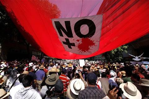
Protest march against drug violence (Mexico City, May 2011)

Protest march against drug violence (Mexico City, May 2011)

Finally, there is some good news. As has been reported elsewhere —Mexico winning cartel war—Mexico does appear to be making progress against the cartels. Numerous cartel leaders have been arrested or killed. This has led to renewed clashes between cartels as some seek to exploit perceived weaknesses in their rivals. Some splinter groups appear to be leaderless; their rank and file have lost their previous sources of income and so are now engaging in more localized acts of petty crime. Unfortunately, these are investigated by poorly equipped state or municipal police forces, rather than their much better-equipped federal counterparts.

As elections loom, there are renewed calls for an end to the violence, which has cost more than 35,000 lives since 2007. Protest marches have been held in many major cities, including one that generated a massive turn out in Mexico City in May (see photo).

Last month, a “caravan of peace” comprised of more than 14 buses and 30 cars began a journey which will take it through some of Mexico’s most troubled regions, including Ciudad Juárez.

Here’s hoping that things soon begin to improve and that we will not need to compile many more updates to Mexico’s war against the drug cartels.

Previous posts about the geography of drug trafficking and drug cartels in Mexico:

Geo-Mexico: the geography and dynamics of modern Mexico discusses drug trafficking, and efforts to control it, in several chapters. Buy your copy today to have a handy reference guide to all major aspects of Mexico’s geography!

Severe hail storm hit central Mexico on 15 May 2011

 Mexico's geography in the Press  Comments Off on Severe hail storm hit central Mexico on 15 May 2011
Jul 072011
 

The severe hailstorm which struck parts of central Mexico on 15 May 2010 lasted up to 30 minutes in some places. It was a particularly intense storm, with golf ball-sized hailstones up to 5 cm in diameter.

The video below was uploaded to YouTube by . (The commentary is in Spanish).

The storm was caused by the southward movement of a strong cold front, which extended along the east coast of the USA and as far south as the Yucatán Peninsula. The cold front collided with hot air slowly circulating in an anticyclonic system that was stationary over central Mexico. The hot air was forced upwards, cooling to form heavy clouds, with moderate to heavy rainfall, and localized thunderstorms and hailstorms.

Despite the fact that Mexico’s National Meteorological Service had issued a weather forecast earlier that day correctly predicting the probability of severe hailstorms in much of central Mexico, damage from the hailstorms was considerable.

In the state of Puebla, 6,600 ha were affected, centered on the town of San Martín Texmelucan. This area included 500 ha of cornfields which were severely damaged. In addition, about 40,000 fruit trees—mainly apple and peach orchards—were badly hit; some of the 200 growers affected claimed that up to 70% of their trees had been damaged.

In Tlaxcala, more than 900 homes were damaged, as well as 1,500 vehicles and 400 ha of farmland. The worst-hit of the nine municipalities involved was Acuitlapilco, but costly damages were also reported from the municipalities of Totolac, Tlaxco, Panotla, Xaltocan, Hueyotlipan, Tecopilco, Atlangatepec and Muñoz de Domingo Arenas. Several emergency shelters were opened, though most of the people made homeless sought shelter with family or friends.

Climatic hazards, including hurricanes and hailstorms are analyzed in chapters 4 and 7 of Geo-Mexico: the geography and dynamics of modern Mexico. Buy your copy today, so you have a handy reference guide available whenever you need it.

Drug gangs diversify their business activities

 Mexico's geography in the Press  Comments Off on Drug gangs diversify their business activities
Jun 282011
 

Wise investors know that diversification is a sound way to protect their resources, and Mexico’s drug cartels have apparently been well educated in this regard. Recent news reports have highlighted two new ways in which Mexico’s drug cartels preserve and grow their wealth: the marketing of pirated merchandise, and the theft and sale of natural gas concentrates.

Marketing of pirated merchandise

According to an article originally published in the Dallas News, Mexico’s drug gangs now make almost as much money from pirated merchandise as from their trade in illicit drugs. By some estimates, the proliferation of pirated brand name goods has resulted in more than 450,000 manufacturing job losses and has caused the demise of many textile, clothing and shoe-making firms. Officials say that pirated videos account for as many as 9 out of every 10 movies sold across the country.

Pirated videos

"Almost original" DVDs for sale in Mexico

Theft of natural gas concentrates

Mexico’s giant Burgos natural gas field, which straddles the northern states of Tamaulipas, Nuevo León and Coahuila, lies in a zone which has become a center for violence in Mexico’s drug wars. Pemex, Mexico’s state-owned oil giant, claims that up to 40% of the gas concentrate produced has been stolen since 2006, as drug gangs have systematically targeted, kidnapped and intimidated oil workers. In some cases, cartels have even constructed their own pipelines to siphon off the gas, before filling their own tankers and driving them across the border using forged documentation.

Pemex has filed suit in Texas against eleven US firms (including Plains All American Pipeline LP, SemCrude, and Western Refining), alleging that they purchased up to 300 million dollars of fuel illegally acquired by drug gangs from Mexican pipelines and then shipped across the border. According to Pemex lawyers, the US firms may have been complicit in the forging of documents required for the gas concentrate shipments to cross the border, and profited (knowingly or unwittingly) from the trafficking of stolen fuel.

Previous posts about the geography of drug trafficking and drug cartels in Mexico:

Geo-Mexico: the geography and dynamics of modern Mexico discusses drug trafficking in several chapters. A text box on page 148 looks at trends in the drug trafficking business and efforts to control it. Buy your copy today to have a handy reference guide to all major aspects of Mexico’s geography!

Mexico imposes seasonal ban on all shark fishing

 Mexico's geography in the Press  Comments Off on Mexico imposes seasonal ban on all shark fishing
Jun 272011
 

According to government statistics, about 21,000 metric tons of shark are landed in the nation’s ports each year. However, many studies have suggested that shark populations are in decline due to overfishing. A series of conservation strategies are being guided by on-going research into shark populations undertaken by scientists attached to the National Fisheries Institute (Inapesca).

As part of Mexico’s efforts to conserve shark populations, the National Fisheries and Aquaculture Commission (Conapesca) has announced a seasonal ban on all shark fishing in Mexican waters. The ban will be in place each year for the main breeding period, May to August. Several other Latin American nations are enacting similar measures.

A representative of shark fishing cooperatives in Mexico said fishermen will fully support the closed season for shark fishing but would expect some compensation for having their boats confined to port for several months each year.

Related posts:

Wildlife trafficking in Mexico: how many wild parrots are illegally captured each year?

 Mexico's geography in the Press, Updates to Geo-Mexico  Comments Off on Wildlife trafficking in Mexico: how many wild parrots are illegally captured each year?
Jun 142011
 

In this post we return to The thorny issues of plant and animal trafficking and biopiracy in Mexico. We highlight several recent news items related to wildlife trafficking, as well as an important survey of the illegal parrot trade in Mexico.

Mexican police launched dozens of raids on stores and markets in March 2010, looking for illegally-traded plants and animals. They collected more than 4500 live specimens, representing more than 110 different species, ranging from cacti and orchids to tropical fish, parrots, reptiles and puma cubs. The mortality rate while transporting illegally-traded animals is more than 90%, according to wildlife experts.

The following month, Mexican federal police rescued 10 tigers and jaguars held captive in Cancún as a tourist attraction, while in June 2010, police at Mexico City’s international airport arrested a Mexican traveler who arrived from Peru with 18 tiny endangered monkeys strapped around his waist. Anyone convicted in Mexico of the illegal trafficking of animals can be sentenced to up to nine years in prison.

The scale of Mexico’s animal-trafficking problem is staggering. For example, according to the Defenders of Wildlife Mexico Program, “It is estimated that between 65,000 to 78,500 parrots are caught illegally every year.” (“The Illegal Parrot Trade in Mexico: A Comprehensive Assessment“)

The states with the worst records for numbers of parrots taken in the wild are Oaxaca and Chiapas (15,000 parrots a year each), Nayarit (12,500), Campeche (10,000) and Guerrero (5,000). Most of these parrots are thought to stay in Mexico, though up to 9,000 a year taken across the border into the USA.

Thick-billed Parrot in captivity

Thick-billed Parrot in captivity

Most of the trafficking in wildlife is carried out by organized international crime networks. Mexico is a major hub for the international trade in wildlife, both because of its rich biodiversity, and because of its proximity to the USA, one of the world’s largest markets for exotic plants and animals. The global trade in illegal wildlife is thought by Interpol to be worth $20 billion a year.

Related posts:

Chapter 5 of Geo-Mexico: the geography and dynamics of modern Mexico focuses on ecosystems and biodiversity.  Chapter 30 analyzes environmental issues and trends including the impact of Old World species imported by the Spaniards, current environmental threats, and efforts to protect the environment.  Buy your copy today to have a handy reference guide to all major aspects of Mexico’s geography!


Children of Mexico’s indigenous groups are disadvantaged from birth

 Mexico's geography in the Press  Comments Off on Children of Mexico’s indigenous groups are disadvantaged from birth
May 302011
 

About 12% of Mexico’s population belongs to one or other of the numerous indigenous groups in the country. According to Mexico’s National Human Rights Commission (NHRC), Indian children under 5 years old are the group with the most needs in Mexico. They have a mortality rate that is 60% higher than that of non-Indian children.

Indigenous children in Mexico

Their disadvantages “increase when they belong to communities characterized by poverty, marginalization and discrimination.” Almost one-third of all children under 5 years of age belonging to Mexico’s indigenous population are below average height and weight. Illiteracy for this group is four times higher than the national average, because many of them leave school early to help their families make ends meet.

Related posts:

Chapter 10 of Geo-Mexico: the geography and dynamics of modern Mexico is devoted to Mexico’s indigenous peoples. Many other chapters of Geo-Mexico include significant discussion of the cultural and development issues facing Mexico’s indigenous groups.

A round-up of news items about Mexicans in the USA

 Mexico's geography in the Press  Comments Off on A round-up of news items about Mexicans in the USA
May 212011
 

This is the first in an occasional series of updates featuring news items relating to the Mexican diaspora, especially that part of it residing in the USA.

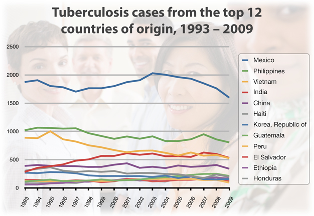
1. Mexico is the leading point-of-origin for foreign-born residents of the USA diagnosed with tuberculosis

The number of TB cases reported in foreign-born persons in the USA was between 7,000 and 8,000 between 1993 and 2008, but fell slightly in 2009. In 2009, 6,854 cases (59% of the total TB diagnoses in the USA) were reported for foreign-born residents. The leading country of origin for these foreign-born TB cases was Mexico, followed by the Philippines, Vietnam, India amd China (see image).

TB cases in USA

TB cases in the USA by country of origin; click to enlarge

A second graph shows that the TB rate (per 100,000 population) has fallen 77% since 1993 for USA-born persons, a much faster decrease than the 45% decrease over the same time period for foreign-born residents. The US Center for Disease Control (CDC) is reported to be working to improve the screening of immigrants and refugees, especially along the USA-Mexico border.

2. Mexican migrants to the USA experience higher rates of depression and anxiety disorders

In 2007, there were about 12 million Mexican-born people in the USA. Mexicans accounted for 30% of the foreign-born population in the USA, and 25% of the US Hispanic population. A study published in the March 2011 issue of the Archives of General Psychiatry suggests that young adult Mexican migrants in the USA are much more likely to suffer depression and anxiety disorders than family members who remained in Mexico. The disorders experienced included depression, dysthymia, social phobia, panic disorder, post-traumatic stress disorder, and generalized anxiety disorder. The risk was highest for those in the 18-25 age bracket. The researchers conclude that this study offers the first direct evidence that “experiences as a migrant might lead to the onset of clinically significant mental health problems in this population”.

3. Hispanic purchasing power in the USA exceeds $1 trillion a year

According to the US Census Bureau, 2010 data show that Hispanics accounted for more than half of the total population increase in the USA over the past 10 years, a trend which is expected to continue. More than 50 million people in the USA are of Hispanic descent, 1 in 6 of the population. The buying power of Hispanics has increased sharply, from less than 4% of the domestic market in 1980 to more than 9% (more than a trillion dollars) in 2010. People of Mexican descent have an estimated buying power of $616 billion a year, easily the single most important segment of the total Hispanic market.

4. Increased remittances in 2010

Remittances sent home by Mexican migrants working in the USA increased in 2010 by 5.5% to $5 billion. The figure comes from Mexico’s central bank.

5. How much do unauthorized immigrants in the USA pay in taxes?

The answer is billions of dollars a year. Like all residents, unauthorized immigrants pay sales tax. Some, even if they rent, also pay property tax. About half of all unauthorized immigrants also pay income tax. The Institute for Taxation and Economic Policy (ITEP) estimates that the state and local taxes paid in 2010 by households headed by unauthorized immigrants may exceed $11.2 billion. That figure is made up by $1.2 billion in personal income tax, $1.6 billion in property tax and $8.4 billion in sales tax.  This is clearly a very considerable contribution to state and federal revenues.

– – –

Migration between Mexico and the USA is the focus of chapter 25 of Geo-Mexico: the geography and dynamics of modern Mexico. Ask your library to buy a copy of this handy reference guide to all aspects of Mexico’s geography today! Better yet, order your own copy…

Mexico’s Magic Towns program to continue at least until 2012

 Mexico's geography in the Press  Comments Off on Mexico’s Magic Towns program to continue at least until 2012
May 202011
 

We had earlier reported that the federal Tourism Secretariat (Sectur) was about to announce the end of the Magic Towns program. Tourism has since announced that the program will continue at least into next year.  [Thanks to reader Jess for her report that the Tourism Secretariat has since announced that the program is being continued, and that there will be 52 Magic Towns by 2012.] The Magic Towns program, founded a decade ago, offered federal funds to promote tourism in towns and small cities throughout Mexico that were not traditional “sun and sand” tourism resorts or destinations.

The most likely towns to be added to the list are:

  • El Oro (Mexico state)
  • Mineral del Pozo (Guanajuato)
  • Sombrerete (Zacatecas)
  • Catemaco (Veracruz)
  • Calvillo (Aguascalientes)

A further 70 towns are reportedly seeking accreditation. Some of these applicants are now likely to join similar promotional groupings such as “Pueblos con Encanto” (Towns with Charm) and “Pueblos Señoriales” (Noble Towns).

Following their designation, many Magic Towns have found it much easier to attract private investments in restaurants, hotels, guide services and similar tourism-related services.

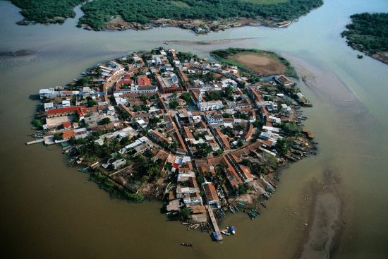
Mexcaltitán

Mexcaltitán, island settlement in Nayarit

One of the very first Magic Towns established—the island community of Mezcaltitán in Nayarit—was stripped of its Magic Town status in 2009 for having failed to keep its streets and building facades clean and for not having limited the activities of informal street vendors.

More impacts of Mexico’s war against drug cartels

 Mexico's geography in the Press  Comments Off on More impacts of Mexico’s war against drug cartels
May 162011
 

Drug trafficking is one of the North America’s major contemporary issues, with widespread ramifications not only for Mexico, but extending well beyond her national borders. This is the first of an occasional series of updates examining some of the numerous different effects of the war on drug-related violence on Mexican society, the environment and the economy.

How many members of Mexico’s military have lost their lives in the war against the cartels?

In “InSight Map: Counting Federal Casualties in Mexico”, Patrick Corcoran takes a look at the confusing statistics relating to the deaths of members of the military in Mexico. The number claimed by the government (470 federal forces killed since 2000) does not match any of the conflicting numbers released on separate occasions by the Defense Secretariat for the number of military personnel killed in the on-going war against the drug cartels.

Drug war violence has decreased press freedom in Mexico

Freedom House, in its annual report, says that Mexico has experienced one of the world’s most radical declines in press freedom. Mexico’s press is now categorized on the Press Freedom Index as “not free”, alongside press in Cuba, Honduras and Venezuela.

More than 60 journalists have been killed in Mexico in the last decade, including 10 in 2010. Many others have been kidnapped, or intimidated. Several journalists have sought asylum in the USA. Drug cartels have increasingly pressured local press and news stations to broadcast partisan material, regardless of its accuracy.

Earlier this year, several major media groups in Mexico agreed to de‑glorify drug trafficking by refusing to show any grisly photos or menacing messages. The pact has been heavily criticized in some sectors, however, mainly on the grounds that it downplays the gravity of the on-going violence.

New laws enacted to protect all migrants in Mexico

It is not only the USA that has problems coping with undocumented or unauthorized migrants. More than 300,000 immigrants pass through Mexico each year on their way from Central America to the USA. Mexico actively patrols its southern border to limit the number of Central Americans who succeed in reaching the interior of the country.

Now, a new federal law expressly recognizes and protects the human rights of all migrants in Mexico, regardless of their place of origin, nationality, gender, ethnicity, age and immigration status. The new law guarantees access to basic services such as health and education. It comes in the wake of the horrific discovery in northern Mexico in recent months of several mass graves of migrants, mainly originating from Central America. The graves are believed to be linked to people-trafficking operations, known to be a source of revenue for drug cartels.

Drug gangs and the price of limes

One unexpected by-product of Mexico’s on-going drug wars in January 2011 was a steep rise in the price of limes, a quintessential ingredient of Mexican food and drinks. Prices in Mexico City quadrupled to almost four dollars a kilo ($1.80 a pound).

The interesting story behind the sudden increase in lime prices is given by Nacha Cattan in The Christian Science Monitor. An accompanying graphic shows how drug traffickers intervened in the normal supply chain, “extorting farmers, attacking produce trucks, or causing more time‑consuming border inspections”.

Most of the limes sold during winter months come from the semi-tropical orchards around Apatzingán, a town in Michoacán, western Mexico. Local truckers have to pay drug gangs up to 800 pesos ($66) a truckload for safe passage. Thefts of fully-laden trucks rose 50% in some areas last year. Allegedly, the gangs also influence prices by limiting harvesting and restricting the operation of packing plants.

Fortunately for Mexican lime-lovers, the price of limes has since returned to normal, with drugs gangs switching their attention to the much more lucrative trade in avocados.

How long will drug-related violence in Mexico last?

Even the Public Security Secretary, Genaro García, has now stated publicly that Mexico’s war on drug cartels will not be over any time soon. He argues that Mexico’s campaign against the cartels is having success, but that organized crime and violence related to drug production and trafficking are unlikely to fall within the next seven years.

Previous posts about the geography of drug trafficking and drug cartels in Mexico:

Geo-Mexico: the geography and dynamics of modern Mexico discusses drug trafficking in several chapters. A text box on page 148 looks at trends in the drug trafficking business and efforts to control it. Buy your copy today to have a handy reference guide to all major aspects of Mexico’s geography!

More problems for residents of Valle de Chalco on the south-eastern edge of Mexico City

 Mexico's geography in the Press  Comments Off on More problems for residents of Valle de Chalco on the south-eastern edge of Mexico City
May 112011
 

More than 200 homes in the low-income settlement of Valle de Chalco on the south-eastern edge of Mexico City, in the State of México, were flooded by raw sewage last month. The affected homes were in San Isidro and La Providencia, in Valle de Chalco (see map).

Mexico City cracks map
Locations in Valley of Mexico with high incidence of ground cracks. Cartography: Tony Burton; all rights reserved.

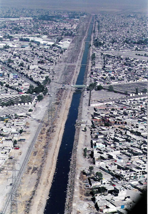
At least 500 residents faced a grim clean-up following several days of flooding. The problem was caused by a 30-meter-long crack in a surface sewage canal known as the Canal de la Compañia. The crack allowed 6,000 cubic meters a second of raw sewage to inundate nearby streets and homes. The federal water authority, Conagua, said that it would take three weeks to complete repairs to the canal wall.

Canal de la Compañia, Chimalhuacán

Canal de la Compañia, Chimalhuacán

The canal wall is thought to have been put under too much pressure due to the unfortunate combination of unusually heavy rains and a blockage occasioned by accumulated garbage such as plastic bags. It is possible that continued ground settling –More ground cracks appearing in Mexico City and the Valley of Mexico – also contributed to the problem. José Luis Luege Tamargo, the head of Conagua, placed much of the blame for the most recent flooding on the local municipal authorities of Ixtapaluca for not having ensured that no garbage was dumped anywhere in or near the Canal.

The 260 families and small businesses affected were all given some immediate financial assistance via 20,000-peso payment cards valid at any Soriano supermarket. In addition, authorities have pumped out basements and begun an emergency vaccination campaign.

The Canal de la Comañia’s walls have failed three times in the past decade, with serious flooding each time; the most recent disaster was in February 2010, when 18,000 people were forced to flee the rising wastewater. Conagua has reportedly proposed a more permanent remedy involving the rerouting of 7 km (almost 5 miles) of canal. The project would take two years to complete, with an estimated cost of 300 million pesos ($25 million).

The on-going transformation of Mexico City

 Mexico's geography in the Press  Comments Off on The on-going transformation of Mexico City
May 082011
 

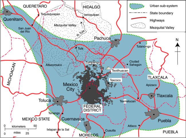
A feature article in thestar.com (link below) summarizes some of the reasons behind our long-held view that Mexico City has started, and is still undergoing, a noteworthy transformation. Change is happening not only in the urban fabric but in many aspects of the daily lives of “capitalinos“, the most polite of the various  terms used in Mexico for residents of Mexico City.

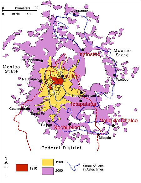
Map of Mexico City urban system

Map of Mexico City urban system. Click to enlarge. All rights reserved.

We will continue to offer occasional updates on the transformation taking place in Mexico City in future posts. Previous posts on this blog have examined many different aspects of Mexico City’s on-going transformation:

Mexico’s cities and towns are analyzed in chapters 21, 22 and 23 of Geo-Mexico: the geography and dynamics of modern Mexico. Buy your copy today!!

Attempts to provide drainage for Mexico City date back to Aztec times

 Excerpts from Geo-Mexico, Mexico's geography in the Press  Comments Off on Attempts to provide drainage for Mexico City date back to Aztec times
Apr 262011
 

An old joke relates how engineers initially rejoiced at successfully draining the former lake on which Mexico City was built (something the Aztecs had tried, but failed to achieve), only to discover that the city now lacked any reliable source of fresh water for its inhabitants (something the Aztecs had successfully managed by building a system of aqueducts).

Water has been a major issue for Mexico City since it was founded almost 700 years ago. Civil engineering works by the Aztecs included causeways and aqueducts connecting their island capital to the mainland as well as lengthy dikes separating the fresh water lakes from the brackish Lake Texcoco which surrounded the city.

The Spaniards did not maintain the Aztec civil works, deforested the surrounding hillsides, and started filling Lake Texcoco. This contributed to major flooding in 1555, 1580, 1604. The city was actually underwater (continuously!) from 1629–1634. During this period the Spaniards invested in several flood control efforts, but they were not successful. In 1788 they started construction of a massive canal to connect the basin to rivers north of the city flowing to the Gulf of Mexico. The open canal, which was up to 30 m (100 ft) deep in places, provided flood relief, but did not completely solve the problem, and flooding continued.

In the mid-1850s the government approved another massive flood relief scheme. Construction of the Gran Canal was delayed by numerous political and financial problems; it was not completed until 1900. The 58 km (36 mi) long canal included a 10 km tunnel, and carried lake water, storm water and sewage north to the Río Salado and eventually to the Gulf of Mexico. The scheme successfully drained most of the basin lakes, but summer flooding continued to be a problem for decades.

Mexico’s deep drainage system (drenaje profundo) was completed in the 1970s. It relies on a 68-km-long central tunnel (Emisor Central) which has a maximum depth of 250 meters below the surface. Built to allow for a flow of 170 cubic meters/second, subsurface subsidence under Mexico City had reduced its maximum capacity to barely 15 cubic meters/second by 2008.

Paradoxically for a city originally built on a lake and which experiences regular summer floods, Mexico City is desperately short of drinking water. The drilling of wells to obtain potable water from the aquifer under Mexico City is one of the main reasons for the ground subsidence which has reduced the effectiveness of the deep drainage system.

Many parts of Mexico City still experience serious drainage problems every rainy season. During the long dry season, many street drains plug with garbage (especially impermeable plastic bags). City motorists dread the first heavy rains of the year since much of the rainwater which falls is unable to find its way underground and backs up from blocked drains. City authorities have an annual campaign to try to clear all drains before the first rains, but are never completely successful.

Since 2007, jointly agreed programs to maintain and renovate the deep drainage system have been undertaken each year during the dry season by Mexico City and the administrations of adjoining states, in an effort to reduce the metropolitan area’s serious flood hazard. In the first four years (2007-2010), more than 42 km of tunnels have been renovated. The 2010-11 season of repairs to the drenaje profundo will be completed before the start of the rainy season (usually in late May or early June), according to city mayor Marcelo Ebrard.

Why are some parts of Mexico City sinking into the old lakebed?

Mexico introduces a carbon tracking system to monitor its greenhouse gas emissions

 Mexico's geography in the Press  Comments Off on Mexico introduces a carbon tracking system to monitor its greenhouse gas emissions
Apr 212011
 

A recent Scientific American article (15 March 2011) examines Mexico’s newly introduced system to track greenhouse gas emissions. The article, by Saqib Rahim, originally appeared in ClimateWire.

Systems to monitor emissions are essential if countries are to know whether or not they are meeting emissions targets. Mexico’s 2012 goal is to cut its greenhouse gas emissions by 6% of their 2000 value. Mexico’s longer-term goal is a decrease of 50% by 2050. Achieving these goals will require massive investments in a range of industries and Mexico hopes that a transparent greenhouse gas accounting system will play an important role in attracting foreign funds.

The system was developed in partnership with Abt Associates, a US consultancy that has contracts with US AID and the US Environmental Protection Agency. Mexican officials insisted that the system must be Internet-based, easy to use, and capable of providing updated reports every few months. Their existing system is spreadsheet-based, but relies on databases that are not 100% compatible in terms of the information and measurements recorded.

The new system allows officials to categorize emissions data by economic sector and geographic region, down to the level of an individual firm or a single municipality. Indonesia has already expressed its interest in the system, and it is hoped that other countries will now follow Mexico’s lead and adopt a similar strategy for keeping track of their own greenhouse gas emissions.

Why Mexico plays an important part in one firm’s vertical integration of the citrus fruit industry

 Mexico's geography in the Press  Comments Off on Why Mexico plays an important part in one firm’s vertical integration of the citrus fruit industry
Apr 162011
 

In an earlier post, we looked at the geography behind the cultivation of oranges in Mexico. In this follow-up, we report on an example of vertical integration in the citrus industry. Vertical integration occurs when the same firm controls several successive stages of the production of an item. In this case, the same firm that grows the citrus fruit also packages it and ships it to markets and consumers.

Paramount Citrus, based in the USA, but with orchards also in Mexico, is our chosen example of a vertically-integrated citrus-growing and marketing firm. The firm specializes in Persian limes (it is the largest supplier of fresh limes in the USA), but also grows a variety of other citrus fruits, including Clementine mandarins, Navel oranges and Valencia oranges. But Paramount is not only a grower of citrus, it also packs and ships fresh citrus (including some grown by independent growers) to markets all across the USA.

The advantage to Paramount of having citrus-growing properties in Mexico is that it enables the company to supply citrus to the US market year-round. For example, Mexican “lemons should start shipping as early as July, will peak in August and
September and finish up by mid-November,” according to a company representative.

Paramount currently harvests more than 12,000 hectares (30,000 acres) of citrus a year. This figure includes 2,400 hectares (6,000 acres) of lemon groves near Tampico in Tamaulipas, that the company bought in 2008. Paramount is now expanding its operations in Mexico by completing the purchase of an additional 3,800 hectares (9,500 acres) of lime orchards in the Gulf coast state of Tabasco.

Micro-businesses help improve the economic and social outlook for irregular settlements

 Mexico's geography in the Press  Comments Off on Micro-businesses help improve the economic and social outlook for irregular settlements
Apr 072011
 

In previous posts about Mexico City’s low-cost and “irregular” housing areas, we have seen how the residents of Ciudad Nezahualcóyotl (Nezahualcoyotl, an irregular settlement which grew into a monster) have gradually transformed their urban environment, and are now regarded by some as part of Mexico’s growing middle class (Are the residents of Ciudad Nezahualcóyotl becoming middle class?).

Historically,  low-cost housing areas (Informal settlements or “colonias populares” in Mexico’s cities) have been established throughout the Mexico City metropolitan area, with the notable exception of the city’s high status western sector. The highest concentrations of colonias populares are in the industrial zones, at the periphery of the city, and in undesirable areas such as the former lakebed near Lake Texcoco which is unstable and prone to severe flooding. (See, for example, Subsidence incident leads to demolition of 31 homes in the State of Mexico).

In the 1950s, in an attempt to control urban growth, the Federal District government started to oppose the formation of new colonias populares. In contrast, the neighboring State of Mexico tolerated, and even encouraged, the development of such communities, explaining why numerous colonias populares were established just beyond the Federal District boundary, in municipalities such as Naucalpan, Tlalnepantla, Ecatepec, Chimalhuacán, and Nezahualcóyotl.

Many of these settlements grew very rapidly. For example, Chimalhuacán, on the Texcoco lakebed, just north of Nezahualcóyotl, grew from 20,000 in 1970 to 525,000 in 2005 and 614,000 in 2010. Similarly, Valle de Chalco Solidaridad, on the lakebed of the drained Lake Chalco, and alongside the main highway from Mexico City to Puebla, went from 44,000 in 1970 to 332,000 in 2005 and almost 358,000 in 2010. Currently, about 60% of the Mexico City Metro Area’s population lives in colonias populares.

Over time, almost all of the older, longer-established colonias irregulares in Mexico have been improved, though new ones still spring up almost overnight. It may take 10 years or so for them to look like a regular settlement and acquire some basic urban services (water, electricity, drainage). The first settlers starting a new irregular settlement are often referred to as paracaidistas (parachutists) in reference to the fact that they apparently arrive out of nowhere!

A recent article in Forbes magazine looks at how small businesses in Chimalhuacán are helping to transform the urban landscape and offer increasing opportunities for its residents.

The population figures quoted in the article must refer to a larger area than just the municipality of Chimalhuacán, but the processes described are typical of many colonias populares, augmented in this case by particularly enterprising entrepreneurs.

Prior to the 1960s, villages with telephone service in most parts of Mexico were served by a single “caseta” (phone booth), which inevitably became a center for village gossip. The early adopters who installed the first public phone booth in a particular village usually prospered, encouraging others to follow suit. Back then, phone service was mostly about keeping in touch with family, but now phones promise access to all kinds of services. The  contemporary phone booths (called Barafón, cheap phone) in Chimalhuacán, described in Forbes, greatly improve people’s access to affordable phone service, enabling them to obtain health care and employment information, as well as operate micro-businesses more efficiently.

As the Forbes article concludes, “While the imagery and condition of one of Mexico’s largest urban slums is grim, closer inspection reveals a thriving and ever so gradually modernizing environment.” Indeed. Like many other colonias populares, Chimalhuacán is well on its way to joining the 21st century.

Related posts:

Mexico’s cities and towns are analyzed in chapters 21, 22 and 23 of Geo-Mexico: the geography and dynamics of modern Mexico. Buy your copy today!!

Rising Chinese labor costs: good news for Mexico

 Mexico's geography in the Press  Comments Off on Rising Chinese labor costs: good news for Mexico
Mar 312011
 

As labor costs in China rise, so more companies located there pull up stakes and move to Mexico, according to Spanish-language press reports. In 2002, wages were estimated to be 240% higher in Mexico than in China; the difference now is just 14%, and this is balanced by the savings in transport costs resulting from Mexico’s proximity to the USA. In addition, Mexican manufacturers tend to source more components from the USA than their Chinese counterparts.

In 2010, for the first time since China joined the World Trade Organization in 2002, Mexico’s share of US imports rose faster than China’s share. In 2010, Mexico had about 12% of the US import market, compared to China’s 19%.

Companies that have moved some or all of their production in the past year from China to Mexico include Meco Corporation (folding chairs and garden barbecues) which is opening a plant in Saltillo (Coahuila), and Coach Inc (premium leather goods). Mexico’s manufacturing exports jumped 30% in 2010 to 246 billion dollars.

See also:

Updates on the geography of Mexico City (26 March 2011)

 Mexico's geography in the Press  Comments Off on Updates on the geography of Mexico City (26 March 2011)
Mar 262011
 

This is the second in our series of periodic round-ups of news items related to the geography of Mexico City. The link to our first update in the series is Updates on the geography of Mexico City (13 December 2010)

Water meters in Mexico City

Ooska News reports that the SACM (Sistema de Aguas de la Ciudad de México, Mexico City Water System) plans to replace, repair or install 600,000 water meters for Mexico City before the start of the rainy season. About 300,000 of the 600,000 meters will be repairs or replacements; the other half are new installations. The cost of new meters will be added to the property’s water bill. The city government is considering how to help low-income residents meet the necessary payments. Residents living in parts of the city which as yet have no meters pay a fixed annual charge for water irrespective of the amount they consume. Having meters installed, so flows and consumption can be monitored, is absolutely essential as the SACM tries to tackle the problem of leaks in the water pipes supplying homes in the city. Some analysts estimate that as much as 25% of the water entering the system is lost through leaky pipes before it reaches its intended end-user.

Plastics recycling in Mexico City

Plastics recycling is one component of Mexico City’s waste separation program, which was established in response to the Solid Waste Law passed in 2003. Members of Mexico’s National Association of the Plastics Industry (a nationwide grouping of plastics makers) are investing $150 million in a pilot project to boost plastics recycling in Mexico City. The project seeks to increase the volume of plastic waste collected and reused by at least 10%.

Currently in Mexico City, only 12% of the 13,000 tons of waste generated each day is plastic, even though, by volume, plastics account for between 30 and 40% of all the waste generated.

Assuming the pilot project proves to be a success, the plastics collection and reuse program could be extended to the remainder of the country, leading to the possibility of doubling current recycling rates to around 35% of the 6 million tons of all kinds of plastics used each year.

Can Mexico’s Environmental Agency protect Mexico’s coastline?

 Mexico's geography in the Press  Comments Off on Can Mexico’s Environmental Agency protect Mexico’s coastline?
Mar 242011
 

A case study of the Cabo Cortés tourism megaproject in Baja California Sur

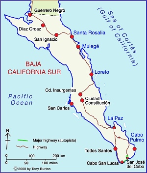
Baja California Sur MapThe Cabo Cortés megaproject is planned for the area near Cabo Pulmo on the eastern side of the Baja California Peninsula. Cabo Pulmo, a village of about 120 people, is about an hour north of San José del Cabo, and on the edge of the Cabo Pulmo National Marine Park.The area is a semi-arid area, where water provision is a serious challenge.

The megaproject is centered on an extensive belt of mature sand dunes which fringe the coast immediately north of Cabo Pulmo.

The megaproject has been in the planning stages for several years, but Mexico’s federal Environment and Natural Resources Secretariat (Semarnat) recently gave Spanish firm Hansa Urbana the green light to begin construction. The controversial plans for Cabo Cortés involve building on the virgin sand dunes, and will undoubtedly have adverse impacts on the small village of Cabo Pulmo and the ecologically-sensitive Cabo Pulmo National Marine Park.

The Semarnat decision provoked the immediate ire of Greenpeace and other environmental campaigners, as well as local residents who fear being displaced from the small village of Cabo Pulmo by a proposed marina.

The value of the Cabo Pulmo National Marine Park

Jacques Costeau, the famous ocean explorer, once described the Sea of Cortés as being the “aquarium of the world.” This area of the Sea has been protected since 1995 and is now designated a National Marine Park. It was declared a “Natural Patrimony of Mankind” by UNESCO in 2005. The protected area, ideal for diving, kayaking and snorkeling, covers 71 sq. km of ocean with its highly complex marine ecosystem. Dive sites include underwater caves and shipwrecks.

The biological productivity of the Marine Park is amazing. Since the National Marine Park was established, the number and size of fish inside the park boundaries have increased rapidly. Studies show that the number of fish has more than quadrupled since 1995, owing to the exceptional productivity of the offshore reef area. The park is an outstanding example of the success of environmental protection efforts.

Cabo Pulmo is on the Tropic of Cancer, about as far north as coral usually grows. The water temperatures vary though the year from about 20 to 30 degrees C (68 to 86 degrees F). The seven fingers of coral off Cabo Pulmo comprise the most northerly living reef in the eastern Pacific. The 25,000-year-old reef is the refuge for more than 220 kinds of fish, including numerous colorful tropical species. Divers and snorkelers regularly report seeing cabrila, grouper, jacks, dorado, wahoo, sergeant majors, angelfish, putterfish and grunts, some of them in large schools.

The tourism megaproject

The project involves an area of 1,248 hectares (3,000 acres). Swathes of land will be cleared for two 18-hole golf courses. Water provision will require the extraction of 4.5 million cubic meters of groundwater a year from the Santiago aquifer, and the construction of 17 kilometers of aqueducts. The planned marina has 490 berths. When complete, the megaproject will offer more than 27,000 tourist rooms, almost as many as Cancún has today, and almost three times as many as currently in nearby Los Cabos. It is estimated that Cabo Cortés will generate 39,000 metric tons of solid wastes a year (about 2 kg/person/day).

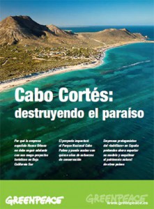
Cover of Greenpeace's position paper on Cabo Cortés

Cover of Greenpeace’s position paper on Cabo Cortés

NGOs oppose Cabo Cortés

When challenged about the legality of granting permission for a project which will impact the Marine Park, Semarnat officials have claimed that the ecological criteria in Semarnat regulations are “suggestive” rather than “obligatory”.

Several NGOs have already launched protest campaigns. Alejandro Olivera is spearheading Greenpeace’s opposition to Semarnat’s decision. He has described the decision as “erroneous” and claims that the megaproject is “not congruent with the prevailing ecological regulations for the region, given that the construction of the marina is in direct contravention of the Los Cabos Ecology Plan which covers this region. The plan expressly prohibits any construction on shoreline dunes. Semarnat maintains that its authorization of a marina and elevated walkways will not affect the “structure or functioning of the area’s sand dune system”.

Olivera emphasizes that Greenpeace is not opposed to tourism as a development strategy, but that it believes in sustainable (responsible) tourism that respects the area’s carrying capacity. Meanwhile, a Greenpeace Spain spokesperson claims that the resort development model of Hansa Urbana, is fundamentally flawed and outdated, and that, when implemented in Spain, it resulted in unacceptable social and environmental costs.

Amanda Maxwell of the Natural Resources Defence Council (NRDC) has written a good summary of why the Semarnat decision should be opposed, entitled “Approval of the Cabo Cortés resort complex–next to the healthiest coral reef in the Gulf of California–is a huge step backward for Mexico

The 120 or so local residents who live in Cabo Pulmo village also oppose the plan and have formed an NGO called Cabo Pulmo Vivo. The existing village, which has no street lights, is a haphazard collection of homes and small businesses, including dive shops, stores and restaurants.

Cabo Pulmo Vivo organized on online petition calling for the Semarnat permits to be revoked.

Personal view, written following a visit in 2008

“We arrive in Cabo Pulmo as the sun is setting, relieved to finally find the end of the initially paved, then dirt, access road, which has been bounded by barbed wire ever since we caught our last clear views of the coast near La Ribera. At intervals behind the barbed wire are warning signs making it very clear that the land either side of the road is private.

Over a beer with Kent Ryan, the owner of Baja Bungalows, our base for the next few days, I learn that the newly erected fences mark the beginning of a major development of the coast immediately outside the National Marine Park. When I eventually got a chance to examine the masterplan, I can only say that I’m glad we visited Cabo Pulmo in early 2008 before this coast is changed for ever.” (Tony Burton in MexConnect)

Further information:

For an exceptionally informative series of papers (in Spanish) on all aspects of tourism and sustainability in Cabo Pulmo,  see Tourism and sustainability in Cabo Pulmo, published in 2008.

Another valuable resource (also in Spanish) is Greenpeace Spain’s position paper entitled Cabo Cortés, destruyendo el paraíso (“Cabo Cortés: destroying paradise”) (pdf file)

Is this the beginning of the end for blue corn tortillas?

 Mexico's geography in the Press  Comments Off on Is this the beginning of the end for blue corn tortillas?
Mar 212011
 

In two previous posts, we looked at the contentious debate surrounding the introduction of GM corn to Mexico.

Now, Mexico’s Agriculture Secretariat has approved a pilot program by Monsanto to sow up to 1 hectare (2.47 acres) in the northern state of Tamaulipas with GM corn. Only a few months ago, Monsanto, the giant, global biotech seed company, had been refused permission for this project.

Tamaulipas farmers had campaigned to be allowed to try the GM seed on the grounds that it was the only way they could be competitive with corn farmers north of the border. US farmers have found that GM corn lives up to its advertised higher yields and disease resistance, though many Mexican farmers, especially those in the south of the country, are vehemently opposed to GM corn on the basis that cross-contamination would deplete the plants’ gene pool, and possibly lead to the eventual extinction of traditional corn varieties.

The introduction of GM corn is likely to hasten the demise, or at least the ready availability, of many distinctive native varieties, including some with multi-colored kernels and, my particular favorite, blue corn, which makes (IMO) the most delectable tortillas imaginable.

Mexico takes on childhood obesity

 Mexico's geography in the Press  Comments Off on Mexico takes on childhood obesity
Mar 202011
 

As we noted in a previous post – Soft drinks, obesity, ,diabetes and public health in Mexico – Mexico has one of the highest obesity rates in the world, and public health officials are increasingly alarmed by the rapid rise in child and youth obesity. About one-third of children in Mexico are now classified as either overweight or obese.

A recent news article – Mexico puts its children on a diet – describes initial reactions to a new federal initiative which attempts to improve the diets of schoolchildren. School lunches are almost unheard of in Mexico, but almost all students have access to food during recess or on the way home, whether  organized by local parents, or from local stores or school vending machines.

The federal regulations to restrict the kinds of food available in schools met stiff opposition from some soft drinks and snack food manufacturers, who see youthful consumers as a guaranteed path to future success. Most fried foods have now been removed from schools, but the plethora of regulations still contains many anomalies.

The battle of student waistlines may have begun, but the war on childhood obesity is very far from over.

Consumer shopping habits and regions in Mexico

 Mexico's geography in the Press  Comments Off on Consumer shopping habits and regions in Mexico
Mar 172011
 

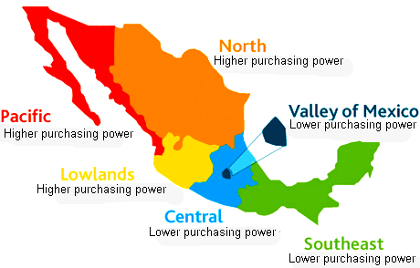
Nielsen, the world’s leading consumer information and research company (offices in more than 100 countries), recently analyzed the shopping habits of consumers in Mexico. From a geographical perspective, one of the most valuable aspects of the study is Nielsen’s use of consumer purchasing habits to suggest a division of Mexico into distinct shopping regions.

The market for consumer goods in Mexico is very large, and has grown rapidly since the 1980s. Mexico is now the world’s 11th most populous nation (112.3 million people in 2010) and has the world’s 11th largest economy. It is also the most populous Spanish-speaking country in the world. Mexico’s size and diversity result in great variations in consumer patterns from one area to another. To achieve maximum success, manufacturers, distributors and retailers in Mexico need to appreciate these regional differences.

Mexico's consumer regions

Mexico's consumer regions. Credit: Nielsen

As we have stressed in previous posts, Mexico has a marked north-south divide. Inhabitants in the north tend to be better-educated and live in smaller households, with higher household incomes and more purchasing power than their counterparts in southern Mexico. The Nielsen study broadly supports this division of wealth, but adds some refinements to the pattern.

The map summarizes Nielsen’s view of the pattern of Mexico’s consumer habits. Throughout the country, small traditional stores (defined by Nielsen as those stores where a salesperson or clerk must be present to serve shoppers) remain a vitally important option for consumer purchases.

Convenience stores and small supermarkets are most popular in Nielsen’s Pacific and North areas. Larger supermarkets are more important in the Valley of Mexico and in the Southeast region.

In all regions, traditional convenience stores are visited frequently, either daily or even twice-daily. Consumers typically visit the nearest supermarket twice a week, with Sunday being the single most popular shopping day. Mid-week supermarket shopping is most common in the Pacific, North and Southeast areas.

Related post:

Mexican migrant farmworkers in the USA

 Mexico's geography in the Press, Teaching ideas  Comments Off on Mexican migrant farmworkers in the USA
Mar 152011
 

The Economist (December 18-31, 2010) has a three-page article about migrant Mexican farmworkers, entitled “Fields of tears: they came to America illegally, for the best of reasons” (subscription required for web access).

This article is a great educational resource, offering dozens of possible debating points. It relates the adventures and misadventures of a young family from the state of Oaxaca, following them from their initial decision to leave for “El Norte” (USA) to their successive attempts to cross the border. They finally succeeded and “joined the vast undocumented workforce that undergirds America’s food supply”.

The Economist correspondent toiled alongside Mexican field workers as they picked strawberries in temperatures of up to 40 degrees C. (100 degrees F). The article goes on to consider the lifestyles of migrants, their access to services such as education and health care, and the degree to which they are welcomed by native-born Americans.

Looking at the life and motivation of a single family is a highly effective way of gaining familiarity with the multitude of issues related to the major flow of migrants from Mexico to the USA.

Previous posts related to Mexico-USA migration:

Migration between Mexico and the USA is the focus of chapter 25 of Geo-Mexico: the geography and dynamics of modern Mexico. Ask your library to buy a copy of this handy reference guide to all aspects of Mexico’s geography today! Better yet, order your own copy…

Plans for a tourism megaproject in Sinaloa, a Pacific Coast “Cancún”

 Mexico's geography in the Press  Comments Off on Plans for a tourism megaproject in Sinaloa, a Pacific Coast “Cancún”
Mar 072011
 

The National Fund for Tourism Infrastructure (renamed the National Tourism Development Fund, Fonatur, in 1974) began building Cancún in 1970 and Ixtapa in 1971, followed later by Los Cabos, Loreto and Huatulco. Fonatur has also started to develop a mega-project on a stretch of coastline north of Puerto Vallarta known as Riviera Nayarit.

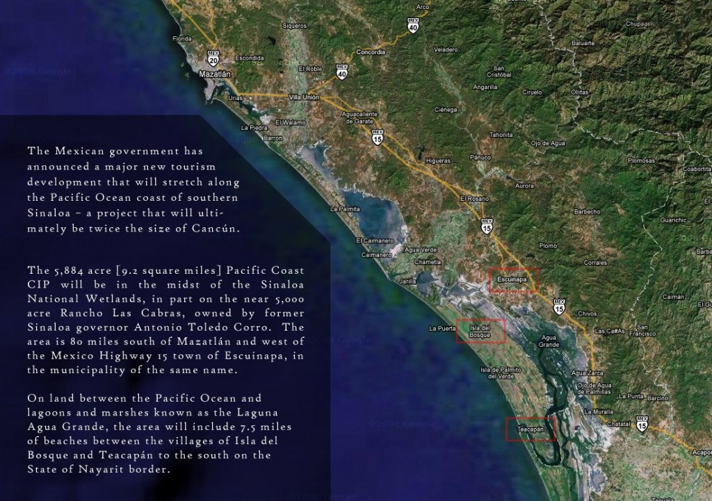
Fonatur’s latest tourism mega-plan, first announced three years ago, is for a resort complex further north on the Pacific coast, in Escuinapa (Sinaloa), about 100 km south of the port city of Mazatlán. As for previous Fonatur purpose-built tourism resorts, Fonatur has prepared an overall land-use master plan, and will finance some of the initial basic infrastructure such as access highways and power lines. The hotels, recreational facilities, residential and commercial areas will be constructed by private developers.

Fonatur Sinaloa

Fonatur Sinaloa. Credit: La Punta Realty - Click to enlarge -

Fonatur Sinaloa is being planned as a “sustainable tourist development” targeting a wide cross-section of tourists by offering opportunities for sailing, spa visits, participatory sports, and a variety of cultural and educational activities. The Escuinapa site comprises 2,381 hectares (double the original area of Cancún) with 12 km of beachfront. The site is surrounded by the Sinaloa National Wetlands, and more than 20% of the area allocated to the resort is being set aside as a protected ecological reserve or conservation area.

The area (see image above from La Punta Realty) is quite easy to access by both highway and air. A divided toll highway goes all the way to the US border, and also connects the location to central Mexico via Tepic and Guadalajara. Two airports are within an hour of the new site: the local Teacapán airport, 26 km away, and Mazatlán International airport, 85 km away.

Fonatur’s business plan claims that the mega-resort will be able to accommodate 3 million tourists a year, with related annual expenditures of 2.8 billion dollars. The master plan for Fonatur Sinaloa envisages 15,000 hotel rooms, 25,000 condominiums, time-share rooms and tourist homes, as well as golf courses, a cruise-ship dock, shopping centers and cultural areas, intersected by interior canals linking the separate sections and creating a variety of aquatic zones.

The project will be developed in ten phases, with an estimated final completion date of 2019.

The changing geography of drug trafficking routes in Mexico

 Mexico's geography in the Press  Comments Off on The changing geography of drug trafficking routes in Mexico
Feb 262011
 

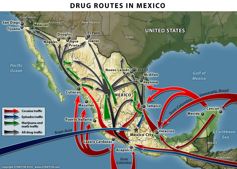
Last year, we reproduced an earlier version of this Stratfor map in The geography of drug trafficking in Mexico. The recently released new version, shown below, shows several changes from the earlier version.

Drug routes through Mexico

Drug routes in Mexico. Copyright Stratfor. Click map for enlarged version.

Map © Copyright 2010 Strategic Forecasting Inc, STRATFOR www.stratfor.com. This map is republished with permission of STRATFOR.

The main changes are that the new map:

  • does not show the territories controlled by each of the major drug cartels. As we have noted previously, the boundaries between cartel territories are hotly disputed and in a constant state of flux.
  • shows more marijuana traffic originating from Jalisco and Michoacán states.
  • labels the importing of ephedra from Asia as coming “from China”
  • adds a new route for ephedra trafficking from Central America through Guatemala and along Mexico’s Pacific Coast towards Acapulco.
  • strengthens the arrows showing a much larger movement of “all drug traffic” northwards from central Mexico through Chihuahua state and towards the border city of Ciudad Juárez, with branches of this flow extending not just to the Pacific Coast (as in the old map) but also to the Gulf Coast.

What do these changes mean?

First, it is apparent that the overall pattern of drug trafficking routes is more complex than originally thought. Shifting alliances between trafficking groups means that the “map” is being constantly redrawn to reflect the changing relative strengths of the different cartels and drug gangs.

These shifts in routes, and in the zones at the margins of each cartel’s territory mean that the focus of drug-related violence in Mexico is not limited to fixed locations, but that virtually anywhere in the country could find itself “in the wrong place at the wrong time” at some point in the future.

This is quite different to the pattern of drug-related violence 30 or 40 years ago, when most of the problems were concentrated in a relatively small number of generally isolated areas where the drugs were actually grown.

To read more posts about the geography of narcotic drugs in Mexico, use the “drugs” tag in the navigation bar on the left hand side of each page.

Other relevant link

Geo-Mexico: the geography and dynamics of modern Mexico discusses drug trafficking in several chapters.  A text box in chapter 20 looks at the drug trafficking business and efforts to control it.  Buy your copy today to have a handy reference guide to all major aspects of Mexico’s geography!