Nov 142013
 

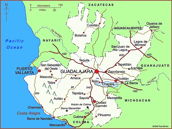
About 160 kilometers (100 miles) north of Guadalajara as the crow flies is a wild and inhospitable arm of the Western Sierra Madre called the Sierra of Bolaños, a rugged northern extension of Jalisco most easily reached by light aircraft. The one way trip by road requires driving more than 320 kilometers (200 miles) from Guadalajara, half the distance being inside the adjacent state of Zacatecas. The Bolaños region has for centuries been an important silver mining area, and British capital and engineers left an indelible mark on the towns there.

Bolaños, the setting.

Bolaños, the setting. Credit: Tony Burton; all rights reserved

The once-grand colonial mining town of Bolaños fits snugly between the river and the rocky cliffs into which the first mine shafts were sunk. Its numerous old stone buildings, often with ornately carved doorways and windows, make it a fascinating place to wander around. With judicious restoration, Bolaños could undoubtedly find its way onto anyone’s list of Mexico’s top mining towns to visit. The town’s hanging bridge (puente colgante) links Bolaños, on the edge of mestizo territory, with the Huichol Indian villages in the mountains on the far side of the river. Huichol artwork, including colorful beadwork, is on sale in several stores in the town and it is common to see traditionally-dressed Huichol Indians in the streets.

Map of Jalisco state

Map of Jalisco. Copyright 2010 Tony Burton. All rights reserved.

Mineral riches

Relatively little is known of the pre-Columbian history of the Sierra of Bolaños but the area was probably only sparsely peopled, perhaps by Tepecano Indians. By the beginning of the seventeenth century, Spanish adventurers had founded the town of Chimaltitán which later served as their base for both subduing the natives militarily and converting them to Christianity. They later founded the towns of Bolaños, a short distance to the north, and San Martín de Bolaños to the south.

By the mid-eighteenth century, the Spanish were in complete control and the Bolaños mines were producing between 2 and 3 million pesos worth of silver per year, or about 25% of the silver production in the whole of New Spain—a very considerable amount, bearing in mind that each peso was then worth about a dollar.

By the 1760s, 16,000 people lived here. Overlooking an attractive small park in Bolaños is the rococo Guadalupe Chapel (the church of San José), a gift to the town from Antonio de Vivanco, owner of several mines. In 1789, de Vivanco became Marquis Vivanco, Viscount of Bolaños.The prosperity of these times is reflected in the sumptuous architecture of the buildings in Bolaños that date from this period. Two particularly fine examples are the Casa de la Condesa, and Antonio de Vivanco’s former home, with its unusual frescoes, both on the street which parallels the river. Bolaños even boasted a two-story Royal Mint, with a lovely facade. Built on one side of the main plaza in the 1750s, this partially restored gem has an Austrian Hapsburg two-headed eagle carved in the stone above its main door. This royal crest may have inspired the local Huichol Indians to use two and even four-headed eagles (a head for each cardinal direction) in their handicrafts.

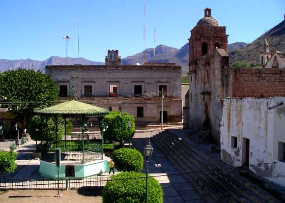
Main plaza in Bolaños

Main plaza in Bolaños. Photo: Tony Burton; all rights reserved

But the boom times of the 1750s were not to last for ever. Following a series of floods (the most serious of which occurred in 1757 and 1781), land disputes, the ever-increasing quantities of costly mercury required for smelting, and disagreements over mining rights, Bolaños’s first boom period came to an abrupt end. By 1798 the town was virtually abandoned. Its largest church, begun in 1778, still stands half-finished; today, this is probably the only place in the world where you can play basketball under floodlights in the shell of an ancient church!

A new company and British miners

British influence in Mexico quickly gained momentum following Mexico’s Independence in 1821. On 27 September 1821, Agustín de Iturbide entered Mexico City in triumph. Most gachupines (Spanish-born residents of Mexico) had fled with whatever assets they could muster back to Spain. The rest were expelled in 1829. Iturbide desperately needed funds, to pay his 80,000-strong army and to set up an administration but, after eleven years of war and chaotic politics, the nation was fatigued and the Treasury empty.

In order to stimulate the Mexican economy, Iturbide needed to revive the mines, many of which had been abandoned during the Independence War. However, the mines had drainage problems and needed large investments of capital. Mexico’s need, coupled with the aspirations and greed of England’s capitalists, proved to be an unstoppable combination. Between 1820 and 1824, no fewer than seven different mining corporations relying on U.K. capital were formed in Mexico. One of these was the Venture Company of the Mines of Bolaños.

The Bolaños Company commissioned a full inspection of their mines. This concluded that, given “modern technology”, a fortune in silver was awaiting exploration, with a potential profit of over a million dollars. The firm’s investors were happy to pour money into bringing British machinery and the ingenuity of expert tin miners from Cornwall to back up their intentions.

In the early days, it was difficult and even dangerous to travel to the mines. No fewer than 15 of the 45 Cornish miners who accompanied the first shipment of machinery for Bolaños in 1825, died through accidents or disease before taking up their posts.

Mine owners had their own agenda. Most insisted that their miners worked completely naked in an effort to thwart any attempted pilfering of ore. Miners grew ever more ingenious in trying to circumvent the rules. They were discovered concealing silver ore in their hair, hollowed-out hammer handles, their mouths and ears, and even, on one occasion, inside the disemboweled body of an overseer killed in an accident!

Despite all the problems the British were determined to succeed. They built a reservoir above the village of Tepec and then a five kilometer long canal, much of it underground, to bring water to the town of Bolaños. On the east side of the small church in Tepec, a camposanto (cemetery) was built specifically for the English miners and their descendants since they were not Catholics and should not therefore be buried in the town’s main graveyard.

To assist in drainage, the British assembled two massive hydraulic wheels, one 12 meters, and the other 14 meters in diameter. Their most important contribution, though, was to import a 32-ton steam engine from the U.K. It took 106 days for this engine to be hauled over the mountains from Veracruz. Locals say that the reason the San José church now has only small bells is because the large ones were melted down to make wheel rims to help move the steam engine.

Bolaños grew into a town of more than 30,000 people, with seven major mines in production, employing thousands of workers. However, despite the mammoth injection of British capital and technology, the company failed to extract enough silver to obtain any return on its investment. In 1842, amidst political rumblings after several accidents and a fire which cost the lives of more than 150 miners, and with the Mexican government delaying payments for silver bars “bought” by the Mint, the company was wound up and Bolaños once again echoed to the sounds of bird-song rather than of hammer, chisel and steam engine.

The town’s population declined to fewer than 5000. It became a ghost town, another casualty of the ever-changing fortunes of mining centers around the world. Various attempts to revive the mines in the late nineteenth century by North American interests came to nothing. At the end of the last century, a U.S.-Mexico joint venture mined successfully for some years but finally went out of production in about 1998. Today, Bolaños is still a small town, a mere shadow of its former self, though one offering a few small hotels and ample opportunities for adventure, eco- and cultural tourism.

Twenty kilometers south of Bolaños, down the valley and past Chimaltitán, is San Martín de Bolaños. The El Pilón mine, near San Martín, opened in the 1980s, is the only mine currently operating in the valley. By 2007, it had produced over 30 million ounces of silver, as well as some ancillary gold.

A visit to this remote corner of Jalisco provokes deep feelings of admiration for the courage and audacity of all those who chose to settle here, including the nineteenth century British immigrants who left a Europe torn by upheaval, in search of fame and fortune in Mexico.

This is a lightly edited excerpt from chapter 23 of my Western Mexico: A Traveler’s Treasury (4th edition, 2013)

Other posts related to Bolaños:

The growth of the city of Monterrey, Mexico’s industrial powerhouse

 Excerpts from Geo-Mexico, Other  Comments Off on The growth of the city of Monterrey, Mexico’s industrial powerhouse
Oct 282013
 

A series of historical maps of the city of Monterrey was published earlier this year in the city’s online Catalog of Buildings of Historic and Artistic Importance in Barro Antiguo, The maps, dated 1765, 1791, 1846, 1865, 1922, 1933 and 1947 respectively, offer a good basis for considering the urban growth of Monterrey, the industrial powerhouse of northern Mexico.

In chapter 22 of Geo-Mexico, the geography and dynamics of modern Mexico, we explained why, “Monterrey does not fit the general Latin American urban model as well as Mexico City or Guadalajara. First, it never really existed as a colonial city. Secondly, its development was more heavily dependent on industry. Thirdly, its relative wealth and progressive leadership in some ways make it more similar to a North American city than a Latin American city. It fits the model only in that it developed a definite high status sector in contrast to lower status industrial sectors, and eventually became spatially fragmented.”

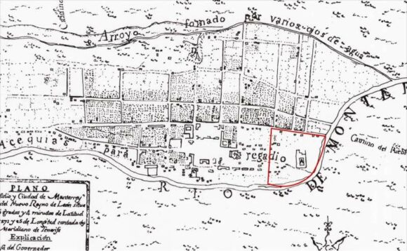
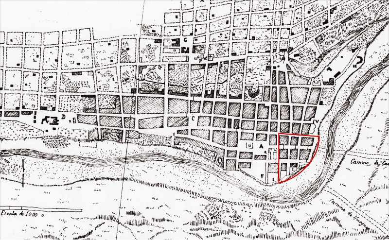
But just how did Monterrey develop as a city? In each of the following historical maps of Monterrey, Barrio Antiguo (16 blocks in size in the present-day city) is marked by a red quarter-circle, which is an easy way to check each map’s orientation and scale. Monterrey was founded in 1596. The earliest map in our series, for 1765, shows that, even by that date, Monterrey was still a relatively small settlement situated between a (seasonally dry) “stream formed by various springs” (to the top of the map, north) and the seasonally-dry “Monterrey River” (now called the Santa Catarina River). The Barrio Antiguo is shown as mostly an empty area, with only one major construction.

Monterrey 1765

Monterrey 1765

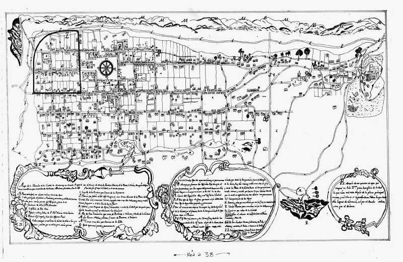
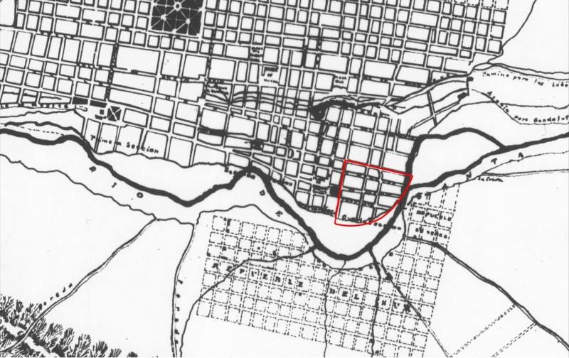
Very little has changed by 1791 (see map below: note that this map is oriented south-upwards), though the Barrio Antiguo has now been developed, and is shows as having several streets in a clear grid pattern:

monterrey-1791

Monterrey in 1791

The grid pattern for Barrio Antiguo is equally evident in the details of the map in 1846:

monterrey-1846

Monterrey in 1846

As of 1846, no development is shown on the south bank of the Santa Catarina River, though tracks are shown heading east and south-east respectively from the city. The next map, for 1865, shows that the city is beginning to expand to the south. A substantial settlement is developing on the south bank, more of less opposite the Barrio Antiguo. Note, though, that this map shows only part of the city:

monterrey-1865

Monterrey in 1865

Clearly, Monterrey only emerged as a real city after the colonial period which ended in 1821. The relatively small city did not experience real growth until late in the 19th century when it became connected by railroad and started to attract industrial development.

Early in the 20th century, investors built the then largest iron and steel works in Latin America a few kilometers east of the city center. Many related industries located nearby. These industries and the railroad, which ran east–west about four kilometers (2.5 mi) north of the city center, stimulated early industrial development in these directions. Developers established low income housing tracts for industrial and other workers on the east, north and west periphery of the city. Neighborhoods for the wealthier classes were developed south of the city center.

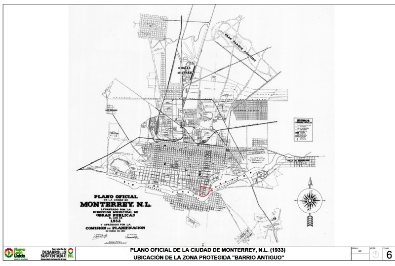
By 1933, Monterrey has grown significantly in area, especially towards the north:

monterrey-1933-whole-city

The city of Monterrey in 1933

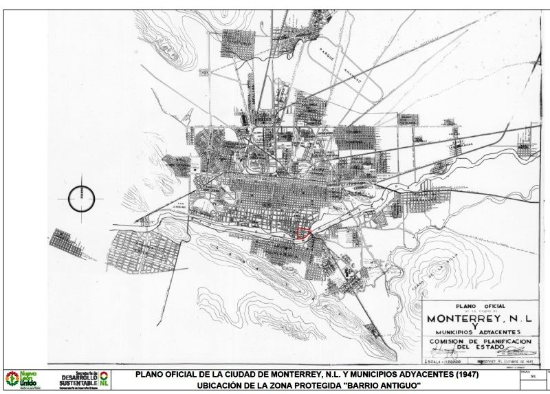
Between 1933 and 1947, the city continues to expand, with many areas being infilled with residences:
monterrey-1947

The city of Monterrey in 1947

The city experienced another surge of industrialization and immigration in the 1950s and 1960s. Industrial development continued after 1970 when the national government implemented policies to shift development away from Mexico City. Monterrey became a major producer of steel, metal fabrication, cement, beverages, petrochemicals, food, telecommunications, auto parts, glass, and house furnishings. It also developed into a major financial center and one of the wealthiest and most progressive cities in the country.

Low income housing became a serious problem after the 1960s as the inner city tenements became extremely crowded. The government was not sympathetic to irregular housing schemes, so low income groups established numerous illegal squatter settlements on vacant land near the industrial zone. Government made a few efforts to remove these, but most survived and eventually became regularized.

The high status sector expanded south-west into San Pedro Garza García, which became one of the wealthiest municipalities in Mexico. The high overall income and wages in the city meant that many workers could afford home ownership and private automobiles. As a result, many gated communities (large and small) and suburban shopping malls were built around the urban periphery. The urban area became relatively fragmented with many low income residential zones located near high income areas.

Source of the maps used in this post:
Other posts about the urban geography of Mexico’s cities:

“Los que llegaron”, Spanish language videos about Mexico’s immigrant groups

 Books and resources, Teaching ideas  Comments Off on “Los que llegaron”, Spanish language videos about Mexico’s immigrant groups
Oct 052013
 

Once TV México (“Eleven TV Mexico”) is an educational TV network owned by the National Polytechnic Institute (Instituto Politecnico Nacional) in Mexico City. Over the years, Once TV México programs have won numerous national and international awards.

Many of its programs are available as webcasts or on Youtube. Once TV México has made hundreds of programs that provide valuable resources for Spanish-language geography classes or for students of Spanish or anyone wanting to improve their Spanish-language skills. For example, their long-running program “Aquí nos tocó vivir” (“Here We Live”) has explored all manner of places throughout Mexico over the past 35 years, and has received UNESCO recognition for its excellence.

Of particular interest to us is “Los que llegaron” (“Those Who Arrived”), a series of programs looking at different immigrant groups in Mexico. Each 20-25 minute program focuses on a different group and explores the history of their migration to Mexico, their adaptation to Mexican life, their integration into society, the areas where they chose to settle, and the links between their home countries and Mexico.

Mexico has a long history of welcoming people from other countries, including political refugees. Each of these programs offers some fascinating insights into the challenges faced by migrants arriving in Mexico for the first time.

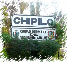
Sister city of Segusino, Italy

Sister city of Segusino, Italy

For instance, the program about Italian immigration to Mexico (above), explains why Mexico was seeking colonizers in the middle of the 19th century in order to populate and develop rural areas. One group of Italians settled in Veracruz (in present-day Gutiérrez Zamora); another group, 3,000 strong, and from the Veneto region in northern Italy, settled in Chipilo, near the city of Puebla. (For anyone not familiar with Chipilo, one of our favorite bloggers, Daniel Hernandez, has penned this short but memorable description of a typical Sunday morning there: Cruising in Chipilo, an Italian village in Mexico).

Italian immigration increased dramatically after the 1914-1918 war. Today, according to the program, there are approximately 13,000 Italian citizens residing in Mexico and an estimated 85,000 Mexicans of Italian descent. Note, though, that most sources quote a much higher figure for the latter category, perhaps as high as 450,000.

[Aside: In chapter 4 of “Mexican National Identity, Memory, Innuendo and Popular Culture”, William H. Beezley looks at the role of itinerant puppet theater in molding Mexico’s national identity. The largest and most famous single troupe of all was the Rosete Aranda troupe, formed by two Italian immigrants in 1850. The troupes went from strength to strength in the next half-century. By 1880, the Rosete Aranda company had 1,300 marionettes and by 1900 a staggering 5,104. Their annual tours around the country helped influence national opinions and attitudes.]

Program list for the “Los que llegaron” series:

  • Españoles (Spaniards)
  • Alemanes (Germans)
  • Húngaros (Hungarians)
  • Italianos (Italians)
  • Argentinos (Argentines)
  • Ingleses (English)
  • Japoneses (Japanese)
  • Estadounidenses (Americans)
  • Coreanos (Koreans)
  • Franceses (French)
  • Chinos (Chinese)
  • Libaneses (Lebanese)
  • Rusos y Ucranianos (Russians and Ukrainians)

Related posts:

Fresnillo, Mexico’s leading silver mining town

 Other  Comments Off on Fresnillo, Mexico’s leading silver mining town
Aug 242013
 

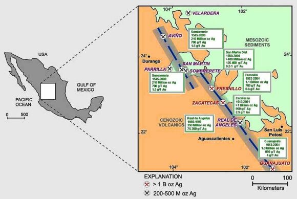
The city of Fresnillo, founded in the sixteenth century, is a place that most people speed by en route to somewhere else. Yet Fresnillo, in the state of Zacatecas, holds several surprises. It was once an important city on the colonial silver route (El Camino Real or Royal Road, the spine of the colonial road system in New Spain), and still boasts many fine buildings, including a lovely old theater and several churches.

fresnillo-plcFresnillo is still an important mining center today. Fresnillo plc, incorporated in the UK, is Mexico’s largest single silver mining company and the country’s second largest gold producer. It operates mines in three major mining zones in Mexico—Fresnillo (Zacatecas), Ciénega (Durango) and Herradura (Sonora)—and is actively developing or exploring numerous other sites.

Fresnillo became a major mining center from 1568, when a garrison of soldiers, complete with a fort, was installed in the town to help protect mule-trains carrying silver from Sombrerete (and the San Martín mine) further north and Zacatecas. By the mid-nineteenth century, Fresnillo’s own mines had serious flooding problems. Mine owners sent to England for experienced Cornish tin miners to come and help. The Cornishmen knew how to assemble and operate powerful steam engines, a novelty at that time in Mexico, and a reliable way to help drain deeper mine shafts.

Location of mining districts near Fresnillo. Credit: 321gold.com

Location of mining districts near Fresnillo. Credit: 321gold.com. Click to enlarge

George Ruxton, a nineteenth century traveler and author, described Fresnillo when he visited as “paltry” but “busy and frenzied” with 2500 miners hacking away at the nearby mountains. Ruxton thought the work ethic of the Cornish was superior to other English settlers and to the local Mexicans. He was especially impressed by how the miners had planted a beautiful garden, full of fruit-bearing trees, complete with a fountain and ornamental summerhouse.

Silver bars were regularly taken from Fresnillo to Zacatecas for smelting and subsequent stamping in the Zacatecas mint. The wagon-trains carrying silver bars, called conductas while under military protection, were frequently assaulted by large groups of bandits, up to several hundred strong.

Fresnillo also has significant artistic interest. Two very famous, yet very different, Mexican artists—musician Manuel M. Ponce and painter Francisco Goitia—were born in (or at least very near) the city in the same year, 1882.

The patron saint of silversmiths

From Fresnillo, it is only seven kilometers along a wide, well-paved road to Plateros, a place of pilgrimage. The baroque Santuario de Plateros was built at the end of the eighteenth century to be a suitable residence for the Santo Niño de Atocha and the Señor de Plateros (the patron saint of silversmiths). The fame of the Santo Niño de Antocha spread rapidly following a fight between two miners. One miner was sure he had killed the other but then prayed to this saint for his recovery. Lo and behold, his companion recovered! Ex-votos (retablos) tell the stories of the numerous “miraculous” interventions performed by the Santo Niño de Antocha to resolve all manner of problems in more recent years.

Source: Most of this post is based on chapter 20 of my “Western Mexico: A Traveler’s Treasury” (link is to Amazon’s “Look Inside” feature), also available as either a Kindle edition or Kobo ebook.

Other Mexican mining towns previously described on Geo-Mexico.com include:

Does tourism in Acapulco match Butler’s resort cycle model?

 Excerpts from Geo-Mexico  Comments Off on Does tourism in Acapulco match Butler’s resort cycle model?
Aug 082013
 

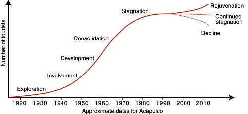
Butler’s resort cycle model applied to Acapulco

Butler’s model (see graphic below) describes the evolution of a tourist resort. His model, similar to a product life cycle model, is quite a good fit with the evolution of Acapulco, a traditional resort which evolved over several decades.

Butler's Model applied to Acapulco (Geo-Mexico Fig 19.7; all rights reserved)

Butler’s Model applied to Acapulco (Geo-Mexico Fig 19.7; all rights reserved)

The model would not be expected to work as well with resorts such as Cancún and Huatulco, which were planned from the start and developed rapidly with the infusion of millions of dollars of federal funds.

In the case of planned resorts, the stages of exploration and involvement are unlikely to apply. The adapted model for such places might perhaps start at the development phase.

Reference for Butler’s Model:

Butler, R.W. 1980. The Concept of the tourist area cycle of evolution: Implications for management of resources. Canadian Geographer 24 (1): 5‑12.

Related posts

Aug 012013
 

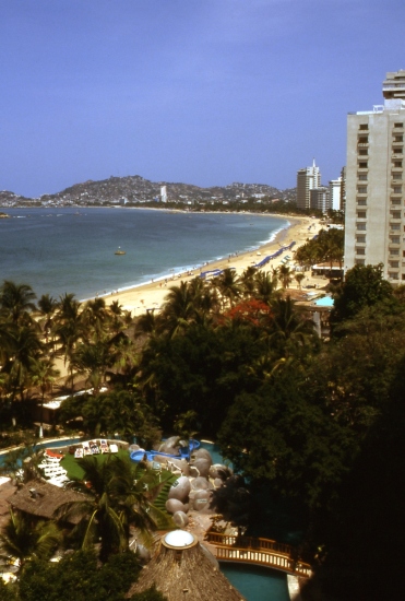
Acapulco was Mexico’s first major resort. Overlooking the Pacific, Acapulco had been fashionable among wealthy Mexicans since the 1920s. The first road from Mexico City to Acapulco opened in 1927; this became a four-lane highway in the 1955 and is now a toll super-highway.

Acapulco, Mexico's first major resort. Photograph by Tony Burton. All rights reserved.

Acapulco, Mexico’s first major resort (Tony Burton; all rights reserved)

The development of Acapulco during the 1940s and 1950s, with new roads, hotels and an airport, provided alternative employment for peasants who had left their land, and helped to reduce the flow of migrants out of the poverty-stricken state of Guerrero. Some viewed Acapulco as a growth pole for further coastal development, but most other coastal towns continued to lag behind for decades. By the 1950s, it had become the playground for Hollywood’s jet set, the world’s first major resort to rely mainly on tourists arriving by air. In the 1960s, Acapulco’s city center was redeveloped and a new airport was built inland.

Acapulco began a prolonged period of stagnation during the 1970s, struggling to cope with urban growth, the provision of adequate urban services and air and water pollution. In the past decade, it has turned things around based on a series of major gated hotel developments that overcome visitors’ security concerns.

Related posts

Early maps of Mexico

 Books and resources  Comments Off on Early maps of Mexico
Jun 152013
 

If you find maps, especially old maps, as fascinating as I do, you’ll enjoy reading the chapter on “Mesoamerican Cartography” (link is to pdf file) in the University of Chicago’s History of Cartography. In this wide-ranging chapter, author Dr. Barbara Mundy explores many aspects of Mesoamerican Cartography, from the different styles and materials used to the subtle changes that followed the arrival of the Spanish conquistadors in the sixteenth century.

The chapter has numerous illustrations of early maps, as well as an interesting diagram showing some of the regional and ethnic differences in the pictographs used to depict common geographic features such as hills, fields, sources of water and stones.

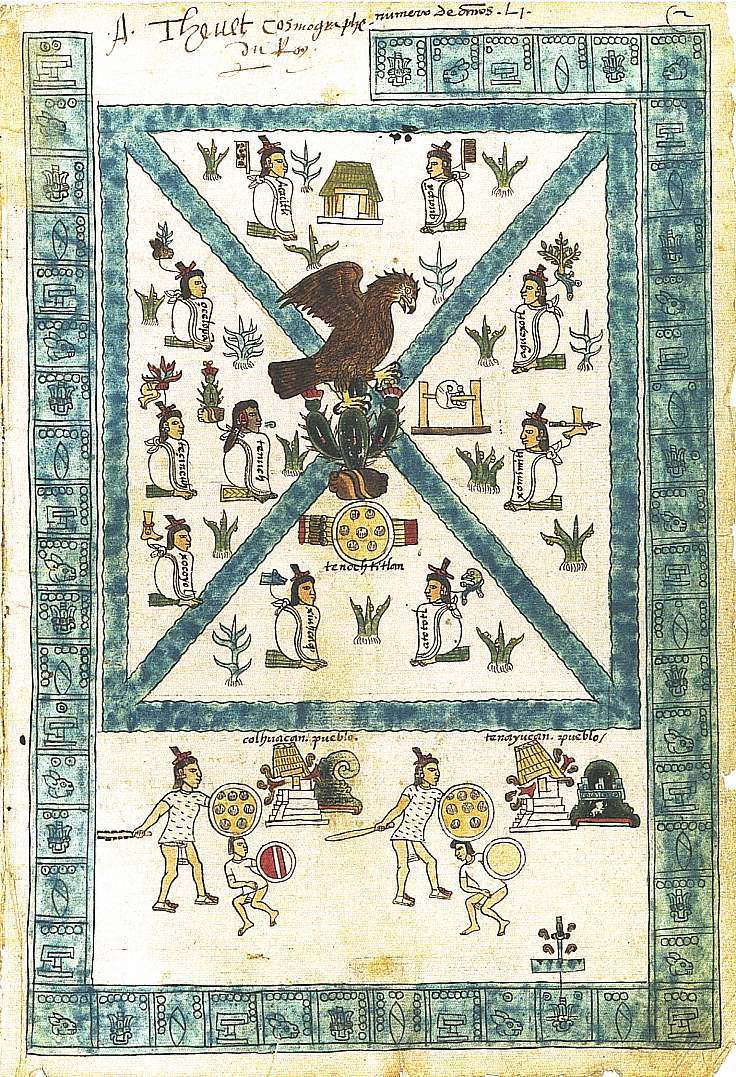
This image shows a page from the Codex Mendoza depicting the Aztec capital Tenochititlan.

Codex Mendoza

Codex Mendoza

The map, thought to have been painted in 1541, shows the founding of Tenochtitlan (by the Mexica) in 1325 (this date is shown by a symbol for a house crowned by two dots in the upper left hand corner). The glyphs around the edge of the map show the passage of time. The central illustration shows Tenochtitlan, dominated by a blue X, marking the four canals that divided the city both geographically and socially. Around the four quadrants sit the ten original founders of the city. Their leader, Tenoch, is seen immediately left of center. The hieroglyphic place-name for Tenochititlan, in the middle of the page, at the juncture of the canals, is a stone with a cactus growing out of it. (Description based on caption in History of Cartography).

On top of the cactus sits a bird of prey (popularly thought to be an eagle, but more probably a Crested Cara-Cara), the sign that the Mexica believed would tell them where to found their new city.

“Mesoamerican Cartography” is chapter 5 of Volume Two, Book Three (“Cartography in the Traditional African, American, Arctic, Australian, and Pacific Societies”) of the History of Cartography. The first volume of the History of Cartography was published in 1987 and the three books that constitute Volume Two appeared over the following eleven years. The University of Chicago Press website has links to a series of pdf files for the first three volumes of the History of Cartography (each chapter is a separate pdf).

Related posts:

The cultural geography of Mexico’s carnival celebrations

 Other  Comments Off on The cultural geography of Mexico’s carnival celebrations
Feb 092013
 

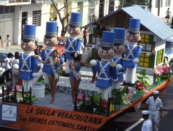
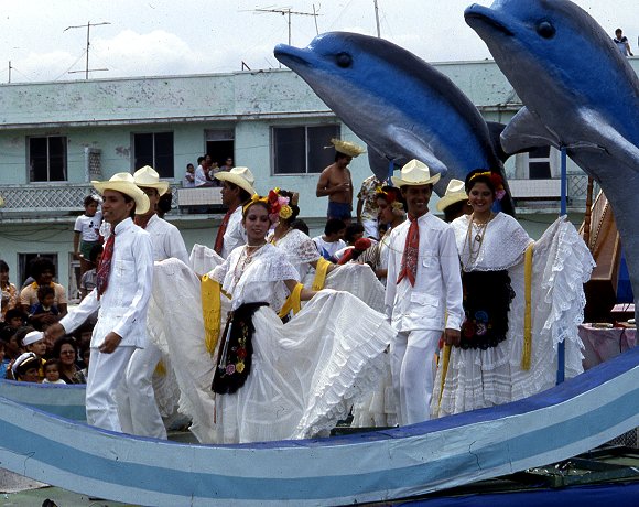
Carnival celebrations are underway in many Mexican towns. Carnival (carnaval) is a time for merry-making in the days prior to Ash Wednesday, the beginning of Lent in the Christian liturgical calendar. (In 2013, Ash Wednesday falls on 13 February.) Carnival originated in Italy and was introduced into Mexico several centuries ago by the Spaniards. Even though the proportion of Mexico’s population that is Catholic has fallen steadily in recent decades – see Religious diversity is increasing in Mexico – the popularity of carnival shows no signs of decline.

Carnival float, Veracruz

Carnival float, Veracruz

According to Wikipedia, more than 220 towns in Mexico celebrate Carnival. Frances Toor, an authority on Mexican folklore, claims that carnival festivities in Mexico City “reached their climax about the middle of the nineteenth century and have died out since the 1910–1920 Revolution.” Very few large cities in Mexico have important carnival celebrations, the most notable exceptions being Veracruz, Mérida and Mazatlán.

Carnival float, Veracruz

Carnival float, Veracruz

By far the most interesting carnival celebrations in Mexico are those held in smaller towns and villages in non-tourist areas. In this regard, the carnival in Huejotzingo, in the state of Puebla, stands out. It is aptly labeled by Toor in “A Treasury of Mexican Folkways”, published in 1947, as “the most elaborate and brilliant of the village carnivals”. Toor describes this carnival in considerable detail, saying that it “dramatizes the capture and death of Agustín Lorenzo, a famous bandit, who with his men used to rob convoys between Mexico City and Vera Cruz and then hide in the near-by gorges or mountains. According to the carnival plot, he ran off with the beautiful young daughter of a rich hacendado, took her to one of his hideouts and was having a wedding celebration when the federal soldiers fell upon them.”

In Toor’s time, about 1000 villagers participated each year, dressed as soldiers in elaborate costumes representing several different battalions. She notes that “In recent years [1940s] some new features have been added to the Huejotzingo carnival. At dawn, all the forces fight against the French, who occupy the plaza, which is besieged and taken. The bride is said to be the beautiful daughter of the French Emperor Maximilian, instead of a rich hacendado”. Today, more than 2000 villagers take part. Most modern descriptions of the carnival in Huejotzingo describe it is an intermixing of three separate plots: the Battle of Puebla (where Mexican forces defeated the French on 5 May 1842), the kidnapping of the mayor’s daughter, and the first Christian marriage in Mexico.

Other places with idiosyncratic carnival celebrations include Huixquilucan (State of México), Calnali (Hidalgo), Tlayacapan (Morelos), Tuxpan de Bolaños (Jalisco), San Juan Chamula and Chenalho (both in Chiapas) and Zaachila (Oaxaca).

This Youtube video clip shows 2012 carnival revelry in Cozumel:

As with almost every aspect of Mexico’s cultural geography, there is no one fixed or rigid “tradition”. Instead, there have been so many significant changes over time that today’s celebrations of carnival across Mexico are characterized as much by their distinctive regional variations as by their similarity.

Related post:

Mexico’s sixteenth century Geographic Accounts: the example of Jiquilpan, Michoacán

 Books and resources  Comments Off on Mexico’s sixteenth century Geographic Accounts: the example of Jiquilpan, Michoacán
Dec 272012
 

In a previous post, we introduced the Geographic Accounts, a rich source of information about Mexico’s sixteenth century geography. The style and substance of a typical Geographic Account can be judged by extracts from the response (dated 1579) relating to Jiquilpan (then written as Xiquilpan), in what is today the western part of the state of Michoacán in western Mexico. In the following (translated) extracts, square brackets enclose editorial comments, not found in the original.

Xiquilpan is in temperate land… A river, which never dries up, passes the village; it carries very little water in summer. In winter, it often rises so much that it can not be crossed. Less than one league from this village towards the north is a lake called Chapala, which is forty leagues around. A lot of white fish and catfish, and another kind of small fish, are caught in it. A large, very full, river, called Chicnahuatengo, enters this lake. [One league is about the distance that could be walked in an hour, from 4.18 kilometers to 6.687 kilometers, depending on the terrain.]

The village is settled on flat and very level ground, without hills…. It is very fertile land. It produces a lot of corn, chile, beans and other seeds that the natives sow. The native fruits are guamúchiles, avocados and guavas. There are lots of figs, pomegranates, quince trees and grapes. It is land where anything that is sown grows….

Xilquilpan has very few Indians: there could be in it about one hundred tributary Indians. They say that before the land was won, there were one thousand two hundred people. After the lands had been won, their number has been diminishing as a result of the many diseases that have occurred. In particular, in [15]76, there was a great plague in this village, common throughout New Spain, from which a large number of people died….

There is a wild plant in this village which cures those who are crippled. It has leaves like a lettuce and is so hot that the part where the root is put burns naturally, like a fire. There is another [plant], which has a root similar to camote: it is a preventative for everything. They cure with these herbs and with others that the natives know….

This village was subject, when it was heathen, to Cazonzi, king of Mechuacan, who ruled over and was in charge of it; on his behalf, he put an Indian chief called Noxti in this village in order to govern and look after them. At that time, they gave corn and chile as tribute to the said Cazonci, which was received by Noxti and sent to Pátzcuaro. At that time, they idolized the Devil, so that he would help them when they went to fight other Indians from neighboring villages. They say that when they caught an Indian, they carried him to a hill next to the village, and there they sacrificed him and offered him to the Devil, and they cut him open and removed his heart and those who had made the sacrifice ate it…

They wore some shawls of joined together sisal, like jackets, without anything else, and cotton breeches, different to what they now wear. Their food was tortillas, tamales, beans, and other wild herbs that they called quiletes [meaning edible herbs or greens in general] and they drank white maguey wine called tlachiquil [unfermented pulque]. They say that they used to live longer than now, and that the reason for this could not be ascertained…

In this village and its surrounding areas, grow pears, figs, pomegranates, grapes, peaches, quinces, nuts, apples, all Castillian [Spanish] fruits. Native [plants] are avocados, sweet canes, guavas, capulines (which are local cherries), squash, chile, tomatoes and a lot of corn. It is land where it does not snow, formerly or now. They raise many birds, both native and from Spain. They grow cabbages, lettuce, onions, radishes, blites, and every kind of vegetable from Spain. Wheat and barley grow in this village.

The animals that there are in the village are wolves, which breed in the swamps that surround some reed beds, a quarter of a league from the village. More than eighty thousand sheep come from other parts to pasture seasonally on the edge of this village each year; it is very good land for them and they fatten very well, since there are some saltpeter deposits in the marsh.

There are no salt beds in this village; the natives supply themselves with salt from Colima, twenty leagues from this village, and from the province called Avalos fifteen leagues away…

Xiquilpan has a monastery of monks of the Order of San Francisco; it has two clerics, one is the guardian. The founder was Brother Juan de San Miguel, and it was founded about forty years ago for all the clerics that were in this province of Mechuacan. The village has a hospital, where the sick are treated, which was begun thirty years ago and founded by a cleric called Brother Alonso de Pineda of the Order of San Francisco. It receives no rents: it is sustained only by the poor, from the alms they beg from the natives.

As can be seen, the Geographic Accounts are of immense value in reconstructing the past history of Mexico. The detail in them is often quite astonishing. However, as René Acuña emphasizes, while the Accounts provide invaluable information about local cultures, including that of the indigenous peoples, they should never be considered completely reliable. They were not eye-witness accounts and often relied on hearsay and on the possibly dubious interpretations made by a relatively limited number of respondents.

Source:

Several transcriptions of the Relaciones geográficas have been published in Spanish. The version used in preparing this article (translations by the author) is Acuña, R (ed) 1987 Relaciones geográficas del siglo XVI: Michoacán. Edición de René Acuña. Volume 9 of Relaciones geográficas del siglo XVI. Mexico City: Universidad Nacional Autónoma de México.

Note: This post is based on an article first published on MexConnect.com

Related posts:

The “Geographic Accounts”: Mexico’s sixteenth century “Domesday Book”

 Books and resources  Comments Off on The “Geographic Accounts”: Mexico’s sixteenth century “Domesday Book”
Dec 132012
 

Mexico’s equivalent of the Domesday Book was compiled in the sixteenth century.

Conquerors often have very little idea of precisely what they have acquired until their victory is assured. In many cases, one of their first post-conquest steps, therefore, is to undertake a comprehensive survey of everything of value, or potential value.

For instance, in 1086, William the Conqueror ordered a survey of his newly acquired England, the results of which were compiled into the Domesday Book. The decision to send out his assessors to every corner of the land was made at his Christmas Court in 1085. As a belated Christmas present to himself, William wanted to know “what or how much each landholder had, in land or livestock, and how much money it was worth”, so that he could tax it accordingly.

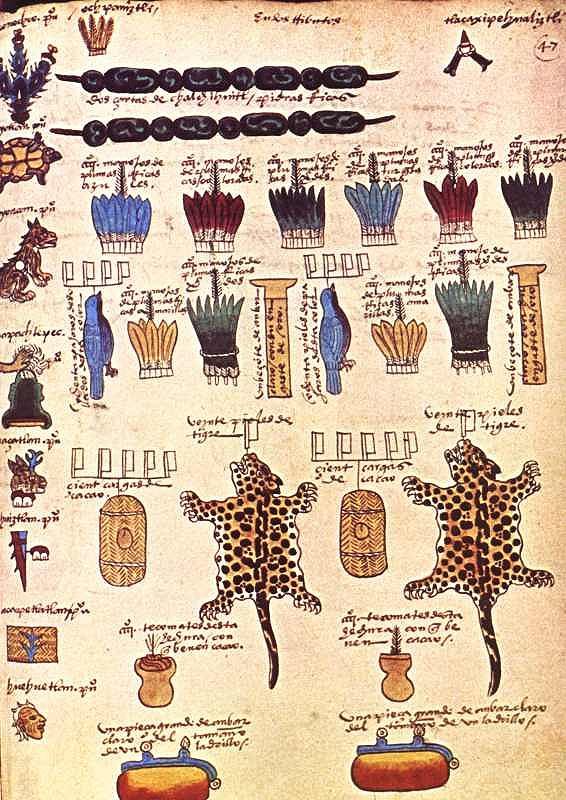
Though less comprehensive, a pictorial record of the wealth of Mexico already existed prior to the Spanish conquest. The Mexica people had gradually established an empire (the Aztec Empire) stretching from the Gulf coast to the Pacific. In order to administer the tributes due from each part of the empire, they recorded the requisite payments of feathers, animals, minerals and food, on bark paper codices. Some of these documents still survive, though most were destroyed by the Spanish. The image below is taken from the Codex Mendoza, which was created shortly after the conquest as a record of Aztec life, including the tributes payable by various villages and towns.

Tribute page from the Codex Mendoza

Tribute page from the Codex Mendoza

In this case, the tribute includes:

  • 2 strings of beads of jadeite, a green semi-precious stone
  • a total of 4000 handfuls of colored feathers
  • 160 skins of the bird with a blue plumage
  • 2 labrets (lip piercings) of amber encased in gold
  • 40 skins of jaguar
  • 200 loads of cacao beans, the main ingredient of chocolate
  • 800 tecomates (cups for drinking chocolate)
  • 2 slabs of clear amber, each approximately the size of a brick

Such tribute lists were of little interest to the Spanish when they arrived. Some of the items held in high esteem by the Aztecs were deemed worthless by the conquerors. Other items, such as silver, of little or no consequence to the Aztecs, were highly prized by the Spaniards.

Back in Spain, the Spanish Court was determined to acquire accurate information about everything being encountered in New Spain. This led to a series of censuses and accounts, including the Relaciones geográficas (Geographic Accounts), the earliest version of which dates back to the late sixteenth century.

In 1569, shortly after Juan de Ovando y Godoy was named Visitor of the Council of the Indies, he sent a questionnaire containing 37 questions to the New World. Another questionnaire, with about 200 questions, was sent in 1570. A few years later, perhaps in an effort to elicit more responses from the provinces, Ovando y Godoy’s former secretary and successor Juan López de Velasco reduced the number of questions to 50. These 50 questions, sent to New Spain in 1577, became the basis for the Geographic Accounts.

The authorities in each administrative center were instructed to call a meeting of the “Spaniards and other natives in the district”, to find out everything they could about the area’s geography, people and history.

Of the 191 known responses to the 1577 questionnaire, 167 have survived in archives to the present day. Most of the original responses are housed in Spain, in either the Archivo General de las Indias (Seville) or the Real Academia de la Historia (Madrid). A further 43 of them form part of the Benson Latin American Collection in the University of Texas library in Austin. The library’s webpage about the Relaciones geográficas has several links to images of sample pages and maps.

A future post will look at the content of a typical example of a “Geographic Account”.

Source:

Several transcriptions of the Relaciones geográficas have been published in Spanish. The version used in preparing this article is Acuña, R (ed) 1987 Relaciones geográficas del siglo XVI: Michoacán. Edición de René Acuña. Volume 9 of Relaciones geográficas del siglo XVI. Mexico City: Universidad Nacional Autónoma de México.

Note: This post is based on an article first published on MexConnect.com

Related posts:

Magic Town #66: Lagos de Moreno, “the Athens of Jalisco”

 Mexico's geography in the Press  Comments Off on Magic Town #66: Lagos de Moreno, “the Athens of Jalisco”
Nov 242012
 

Lagos de Moreno, just designated Mexico’s Magic Town #66, is a town with a charming ambiance. A succession of small squares with old trees and gardens, connected by shaded streets, gives it a cultured university air. At every turn there are beautifully kept old buildings to be enjoyed and it is absolutely fitting that the town, in its entirety, should have been declared a national monument.

Lagos de Moreno is Jalisco’s fifth Magic Town. Boasting more than 380 cultural and historic sites, its peak coincided with the governments of President Porfirio Díaz in the late 1800s when local haciendas produced both an aristocratic elite and plenty of money enabling them to enjoy what they considered were the better things in life.

La Rinconada restaurant, Lagos de Moreno

La Rinconada restaurant, Lagos de Moreno. Credit: Mark Eager / Sombrero Books

Lagos was founded as Santa María de los Lagos in 1563 on the west bank of the broad Lagos River. It assumed its modern name in 1827. In early colonial times, its inhabitants had to withstand repeated attacks from the Chichimecas. When silver was discovered in large quantities near Zacatecas, further north, the town became a natural staging-post on the mule route to Mexico City, where all colonial silver was taken for assaying. At the same time, the main contraband route across Mexico, between Tampico, on the Atlantic, and San Blas, on the Pacific, passed through the town. As a result of this strategic location, the city was fortified with walls, some of which still remain. There are few examples in Mexico of colonial walled cities. Lagos is one of the best preserved.

The width of the river necessitated the construction of a bridge, at least for more modern traffic, and in the eighteenth century Lagos Bridge was built on the northern edge of the town. This bridge is the subject of one of the charming tales in El Alcalde de Lagos (The Mayor of Lagos), a delightful collection of witty short stories compiled by Alfonso de Alba. The stories capture the provincial nature of the town perfectly, complete with the very different perceptions of the local intelligentsia and their rural campesino counterparts as the town grew to maturity.

The imposing ultrabaroque parish church of the Assumption is also eighteenth century and looks onto the principal plaza. Two blocks away, the former Capuchinas convent has been converted into the Casa de la Cultura, with a concert hall, spaces for art exhibits, library and music classes. Few Casas de la Cultura anywhere in the country are housed in quite such an historic or magnificent building. Walk into the patio and see for yourself. The mural inside depicts Pedro Moreno, hero of the Independence movement, who was born near the town, and after whom the town is named. Another building in the Capuchinas square houses the Agustín Rivera Museum with its displays of archaeological and historical items.

Behind the parish church is the Rosas Moreno theater, one of the few provincial theaters to have survived with its interior spaces and decorations unchanged from the end of the nineteenth century. This building, designed by Primitivo Serrano, was begun in 1887, and inaugurated in 1907. It is named in honor of locally-born José Rosas Moreno, the Children’s Poet, a renowned writer of fables. Serrano built many other fine buildings in Lagos de Moreno, and his influence is everywhere in the lovely Hacienda Las Cajas, now a small hotel.

The central area of Lagos de Moreno, with its romantic corners and shaded walks, is a place to wander through slowly, savoring the sights and sounds of an unashamedly provincial town, one proud of its history and still retaining a dignified air. An overnight stay allows visitors to savor the unique atmosphere of this lovely town in the early morning or late evening when lower-angled sunlight shows the colors and details in the stonework to best effect.

[Lightly edited extract from Tony Burton’s Western Mexico: A Traveler’s Treasury.]

Related posts:

Magic Towns #58-62: Chiapa de Corzo, Comitán de Domínguez, Huichapan, Tequisquiapan, Batopilas

 Mexico's geography in the Press  Comments Off on Magic Towns #58-62: Chiapa de Corzo, Comitán de Domínguez, Huichapan, Tequisquiapan, Batopilas
Oct 252012
 

Well… the spate of Magic Town nominations shows no sign of slowing down. The federal Tourism Secretariat has announced that it hopes to have 70 towns in the program before the new administration takes office in December. The latest five additions to the list of Magic Towns are:

#58 Chiapa de Corzo, Chiapas

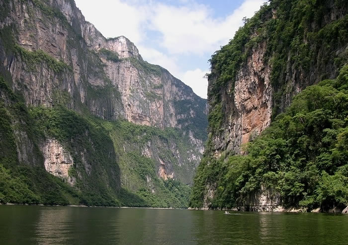
Chiapa de Corzo is a small city (2010 population:  45,000), founded in 1528, located where the PanAmerican Highway (Highway 190) from Oaxaca to San Cristobál de las Casas crosses the River Grijalva, 15 km east of Tuxtla Gutiérrez, in the state of Chiapas. It is the site of the earliest known Mesoamerican tomb burial and has considerable archaeological significance. The massive La Pila fountain, dating from 1562, is one of the most distinctive structures anywhere in Mexico. The town has more than its share of historical interest, including the well-preserved 16th century Santo Domingo church/monastery and a museum dedicated to traditional lacquer work (a local craft). It is best known to tourists as the main starting point for boat trips along the Grijalva River into the Sumidero Canyon National Park.

Sumidero Canyon National Park

Sumidero Canyon National Park

#59 Comitán de Domínguez, Chiapas

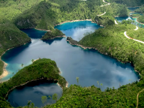
Comitán is a town of about 85,000 people, south-east of San Cristobál de las Casas, and close to the border with Guatemala. The town attracts mainly Mexican tourists on their way to the Lagunas de Montebello National Park and several remote Mayan archaeological sites in the border zone.

Lagunas de Montebello National Park

Lagunas de Montebello National Park

#60 Huichapan, Hidalgo

Huichapan has some interesting history and architecture, but relatively little to interest the general tourist. (Even Wikipedia has little to say about this town!)

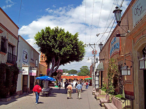
#61 Tequisquiapan, Querétaro

This very pretty town has already been described in several previous posts on geo-mexico.com, including:

Tequisquiapan

Tequisquiapan

#62 Batopilas, Chihuahua

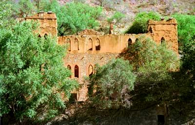
Designated in mid-October 2012. This small town, situated at an elevation of 501 meters above sea level, on the floor of the picturesque Batopilas Canyon, in Mexico’s Copper Canyon region, was once an important silver-mining center. The great German explorer, Alexander von Humboldt called Batopilas the “metallic marvel of the world”. Some of the old buildings in Batopilas have been restored in recent years. Still in ruins is the former dwelling of Alexander Robert Shepherd, one-time Governor of the District of Colombia, USA.

Ruins of former Shepherd mansion, Batopilas

Ruins of former Shepherd mansion, Batopilas

In 1880, Shepherd moved here, complete with family, friends, workers, dogs and grand-piano. His son, Grant Shepherd, describes in his book, The Silver Magnet, how this piano, the first ever seen in this part of Mexico, was carried overland more than 300 km in three weeks by teams of men, each paid the princely sum of US$1.00 a day for his efforts! Shepherd lived here for thirty years, running a silver mine and entertaining stray foreigners who passed through. He employed English servants. When the Mexican Revolution began, he abandoned Batopilas and the mansion fell into ruins. Shepherd is said to have mined more than US$22 million worth of silver here; he was behind the amalgamation of all the mines into a single company, the Consolidated Batopilas Mining Co. in 1887.

Related posts:


The geography of Mexico’s street markets (tianguis)

 Other  Comments Off on The geography of Mexico’s street markets (tianguis)
Oct 082012
 

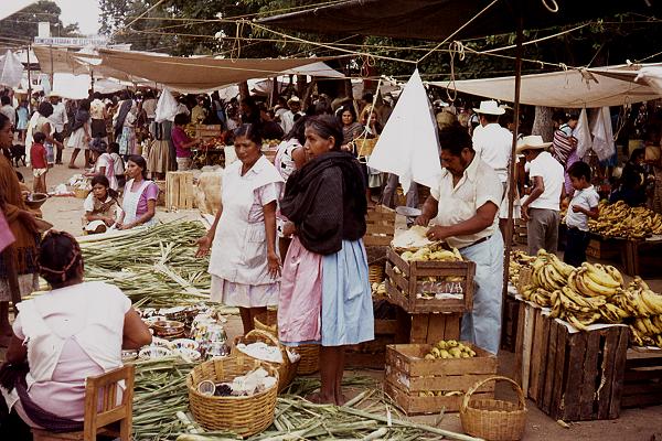
Mexico has some of the finest markets in the world. The variety of produce and other items sold in markets is staggering. But not all Mexican markets are the same. The two major groups are the permanent markets (mercados), usually housed in a purpose-built structure and open for business every day, and the street market or tianguis, usually held once a week.

Street market in Oaxaca. Photo: Tony Burton

Street market in Oaxaca. Photo: Tony Burton

Most tianguis temporarily occupy one or more streets or a public square, though some also use privately-owned land. The origins of the tianguis lie in pre-Columbian times, whereas mercados are a much more recent innovation. In this post, we focus on the tianguis.

The geography of a street market or tianguis

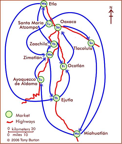
The merchants selling goods in a street market generally visit several markets each week, on a regular rotation (see map for an example of a weekly cycle of markets around the city of Oaxaca). In terms of economic geography, weekly markets allow merchants to maximize their “sphere of influence” and exceed the sales “threshold”, the minimum sales required for them to make a profit, even if they are selling items that may not cost very much, and for which individual consumers are not prepared to travel very far. By visiting, say, four markets a week, these merchants effectively quadruple their potential customers. In terms of social and human geography, these weekly markets are a valuable means of communication, and news from one community quickly travels, via the merchants, to another.

At the same time, these markets give consumers access to a much wider range of goods than would otherwise be possible.

The map shows the market day for major markets, and the major weekly marketing cycles, in the area around the city of Oaxaca. With the exception of Oaxaca city (population 480,000) and Miahuatlán (33,000), all the other towns have populations between 13,000 and 20,000. The merchants at such markets generally carry their wares from village to village on the days of their respective markets. Some local farmers also sell their produce at such markets. For more details, see Markets in and near the city of Oaxaca.

The weekly cycle of markets in and around the city of Oaxaca, Mexico. Map: Tony Burton. All rights reserved.

Mexico has a very long history of street markets, certainly dating back more than two thousand years. The Spanish conquistadors saw, first hand, the very large market of Tlatelolco, in what is now Mexico City, which attracted between 40,000 and 45,000 people on “market day”, which was held every five days.

Markets enabled people living in one region to trade goods produced in another region. In the case of food items this allowed residents of the “hot lands” (tierra caliente) to gain access to food items coming from the “temperate lands” (tierra templada). Some ancient settlements in Mexico are located close to the division between either tierra caliente and tierra templada [usual elevation about 750 meters above sea level] or tierra templada and “cold lands” (tierra fria), at an elevation of about 1800 meters a.s.l. These locations clearly favored the trading and exchanging of items from one major climate zone to another.

Food was by no means the only item traded in markets. Many plants with medicinal value were traded, as were others used for construction materials. It was also common to trade textiles, minerals and household items such as baskets, ceramics and grinding stones, as well as salt, prized feathers and animals.

Even today, most Mexican markets have a distinctive spatial pattern of stalls, with vendors of similar items setting up side-by-side, allowing for comparison shopping. It is a relatively easy and revealing fieldwork exercise to map a Mexican market and then analyze the distribution of different kinds of goods.

We looked in a previous post at how the same basic principle applies to the distribution of shops in many towns and cities.

While most markets traded a variety of items, a handful of specialist markets emerged, especially in the Mexico City area. For example, there were specialist markets for salt in Atenantitlan, dogs (as a source of food) in Acolman, and for slaves in Azcapotzalco and Iztocan.

In a future post, we will look at the origins of the tianguis in the Oaxaca region, a region that is still one of the most fascinating areas in Mexico for markets of all kinds.

Further reading:

Related posts:

Mexico’s three latest Magic Towns (#55, 56, 57) include Loreto, former capital of the Californias

 Updates to Geo-Mexico  Comments Off on Mexico’s three latest Magic Towns (#55, 56, 57) include Loreto, former capital of the Californias
Sep 272012
 

It is getting just as hard to keep up with Mexico’s Magic Towns program as it is to understand why some of the places deserve to be included on the list. Since our last post about Magic Towns, three more places have been added:

#55 Loreto (Baja California Sur)

The attractive town of Loreto [ed: deservedly on the list], is built on the coast around a centuries-old mission. The town has a full range of tourist services, from expensive and ultra-luxurious to budget.

The first colonial Jesuit mission in this region was at San Bruno, 25 kilometers north of Loreto; it was founded in 1683, but lasted only two years. In February 1697, the Spanish Viceroy granted Jesuit priests Juan María de Salvatierra and Eusebio Francisco Kino permission to go to the “California Province“. This is apparently the earliest recorded mention of California as a geographic entity.

The Loreto mission, founded later that year, became extremely successful. Jesuit priests set out from Loreto to found missions throughout the Baja California Peninsula, most of them established by about 1720. Loreto was sufficiently important to function as the capital of the Californias (including the present-day U.S. state) until 1777.

#56 Valladolid (Yucatán)

Valladolid, located about half-way between Mérida and Cancún, is well worthy of Magic Town status. Founded in 1543, it is an attractive colonial city, with wide streets and considerable historical importance. The city has become increasingly popular among discerning tourists in recent years.

There are many attractions, including the numerous superb colonial buildings, such as the Cathedral in the center, and the Franciscan mission of San Bernardino de Siena, in the Sisal district of the city. The local Maya people, in traditional attire, bustle about the central square as they carry out their daily tasks. Valladolid is small enough to explore on foot, by strolling through the different districts of the city.

Coupled with excellent traditional Yucatecan cuisine, natural wonders like Cenote Zaci (a landscaped limestone sinkhole or cenote), pastel-colored walls, friendly handicraft stores, and historical murals in the government palace, what more could a visitor want?

#57 Metepec (State of México)

Metepec is a somewhat nondescript city of 160,000, located near the state capital of Toluca. The earliest Spanish settlers arrived in 1526. Metepec has numerous historic religious buildings, including the Ex-convento de San Juan and the Parish Church of San Mateo. The city’s major claim to fame in terms of handicrafts are ceramic “trees of life” and similar objects. Since 1990, the city has celebrated an annual international arts and culture festival, Quimera, every October.

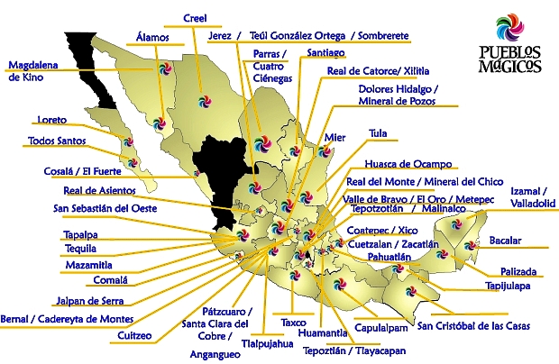
This map from the Tourism Secretariat (Sectur) shows Mexico’s 57 Magic Towns (as of September 2012):

Map of Mexico's 57 Magic Towns (September 2012). Credit: Sectur

Map of Mexico’s 57 Magic Towns (September 2012). Credit: Sectur

How many more Magic Towns will there be? Will the program continue after the new President takes office later this year? Watch this space!

Related posts:

Sep 012012
 

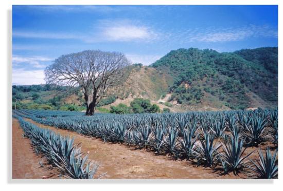
Tequila is made by distilling the juice of certain species of agave plants. Agaves are commonly called “century plants” in the USA, a name derived from the length of time they supposedly grow before producing a flowering stalk – actually, from eight to twenty years depending on the species, rather than the hundred suggested by their common name! Some species flower only once and die shortly afterwards, others can flower almost every year. Agaves are no relation botanically to cacti, even though they are often mistakenly associated with them. The ideal agave for tequila is the Agave tequilana Weber azul which has bluish-colored leaves.

Agave field in Jalisco

Agave field in Jalisco. Photo: Tony Burton

The tequila agaves are started from seed or from onion-size cuttings. When the plants are mature (about 10 years later), their branches are cut off, using a long-handled knife called a coa, leaving the cabeza (or “pineapple”), which is the part used for juice extraction. Cabezas (which weigh from 10 to 120 kilos) are cut in half, and then baked in stone furnaces or stainless steel autoclaves for one to three days to convert their starches into sugars.

From the ovens, the now golden-brown cabezas are shredded and placed in mills which extract the juices or mosto. The mixture is allowed to ferment for several days, then two distillations are performed to extract the almost colorless white or silver tequila. The spirit’s taste depends principally on the length of fermentation. Amber (reposado) tequila results from storage in ex-brandy or wine casks made of white oak for at least two months, while golden, aged (añejo) tequila is stored in casks for at least a year, and extra-aged (extra añejo) for at least three years.

Distillation: the Filipino Connection

Mexico’s indigenous Indians knew how to produce several different drinks from agave plants, but their techniques did not include distillation, and hence, strictly speaking, they did not produce tequila. Fermented agave juice or pulque may be the oldest alcoholic drink on the continent; it is referred to in an archival Olmec text which claims that it serves as a “delight for the gods and priests”. Pulque was fermented, but not distilled.

If the indigenous peoples didn’t have distilled agave drinks, then how, when and where did distillation of agave first occur? In 1897, Carl Lumholtz, the famous Norwegian ethnologist, who spent several years living with remote Indian tribes in Mexico, found that the Huichol Indians in eastern Nayarit distilled agave juice using simple stills, but with pots which seemed to be quite unlike anything Spanish or pre-Columbian in origin.

By 1944, Henry Bruman, a University of California geographer, had documented how Filipino seamen on the Manila Galleon had brought similar stills to western Mexico, for making coconut brandy, during the late sixteenth century.

Dr. Nyle Walton, of the University of Florida, expanded on Bruman’s work, showing how the Spanish authorities had sought to suppress Mexican liquor production because it threatened to compete with Spanish brandy. This suppression led to the establishment of illicit distilling in many remote areas including parts of Colima and Jalisco. Even today, the word “tuba”, which means “coconut wine” in the Filipino Tagalog language, is used in Jalisco for mezcal wine before it is distilled for tequila. This is probably because the first stills used for mezcal distillation were Filipino in origin.

“Appelacion Controlée”

Though colonial authorities tried to suppress illegal liquors, the industry of illicit distilling clearly thrived. One eighteenth century source lists more than 81 different mixtures, including some truly fearsome-sounding concoctions such as “cock’s eye”, “rabbit’s blood”, “bone-breaker” and “excommunication”! By the 1670s, the authorities saw the wisdom of taxing, rather than prohibiting, liquor production.

For centuries, distilled agave juice was known as mezcal or vino de mezcal “mezcal wine”). It is believed that the first foreigner to sample it was a Spanish medic, Gerónimo Hernández, in the year 1651. The original method for producing mezcal used clay ovens and pots.

By the end of the nineteenth century, as the railroads expanded, the reputation of Tequila spread further afield; this is when the vino de mezcal produced in Tequila became so popular that people began calling it simply “tequila”. When the Mexican Revolution began in 1910, it swept away a preference for everything European and brought nationally-made tequila to the fore. Tequila quickly became Mexico’s national drink. It gained prominence north of the border during the second world war, when the USA could no longer enjoy a guaranteed supply of European liquors.

To qualify as genuine tequila, the drink has to be made in the state of Jalisco or in certain specific areas of the states of Nayarit, Guanajuato, Michoacán and Tamaulipas. (We will take a closer look at this distribution in a future post).

The ideal growing conditions are found in semiarid areas where temperatures average about 20 degrees Centigrade, with little variation, and where rainfall averages 1000 mm/yr. In Jalisco, this means that areas at an elevation of about 1,500 meters above sea level are favored. Agaves prefer well-drained soils such as the permeable loams derived from the iron-rich volcanic rocks in Mexico’s Volcanic Axis.

Production of tequila has tripled within the last 15 years to about 250 million liters a year (2010). About 65% of this quantity is exported. Almost 80% of exports are to the USA, with most of the remainder destined for Canada and Europe.

Connoisseurs argue long and loud as to which is the better product, but all agree that the best of the best is made from 100% Agave tequilana Weber azul. I’m no connoisseur, but my personal favorite is Tequila Herradura, manufactured in Amatitán, a town between Tequila and Guadalajara. Anyone interested in the history of tequila will enjoy a visit to Herradura’s old hacienda “San José del Refugio” in Amatitán, where tequila has been made for well over a century. The factory is a working museum with mule-operated mills, and primitive distillation ovens, fueled by the bagasse of the maguey. The Great House is classic in style, with a wide entrance stairway and a first floor balustrade the full width of the building.

Visitors to the town of Tequila, with its National Tequila Museum, can  enter any one of several tequila factories to watch the processing and taste a sample. They can also admire one of the few public monuments to liquor anywhere in the world – a fountain which has water emerging from a stone bottle supported in an agave plant. “Tequila tourism” is growing in popularity. Special trains, such as “The Tequila Express” run on weekends from the nearby city of Guadalajara to Amatitán, and regular bus tours visit the growing areas and tequila distilleries. The town of Tequila holds an annual Tequila Fair during the first half of December to celebrate its famous beverage. Another good time to visit is on 24 July, National Tequila Day in the USA.

In 2006, UNESCO awarded World Heritage status to the agave landscape and old tequila-making facilities in Amatitán, Arenal and Tequila (Jalisco).

Related posts:

Mexico has more World Heritage sites than any other country in the Americas

 Other  Comments Off on Mexico has more World Heritage sites than any other country in the Americas
Mar 172012
 

The status of World Heritage site is a UNESCO (United Nations Educational, Scientific and Cultural Organization) denomination. The status is conferred on selected sites under the terms of “The Convention Concerning the Protection of the World Cultural and Natural Heritage”, adopted at UNESCO’s 17th General Conference in November 1972 and subsequently ratified by 189 member states.

Nations were invited to submit their proposals for any cultural or natural sites that they considered “of outstanding universal value”, and therefore eligible for inclusion on the World Heritage list. All proposals have to be approved by a special UNESCO World Heritage Committee.

The attraction of having a site classified as a World Heritage site is that it affords extra possibilities for obtaining technical co-operation in matters relating to conservation, for international assistance for research, training and equipment, and for emergency assistance in the event of damage due to specific natural or man-made disasters. All these sites are also valuable as cultural or environmental tourism destinations.

The list was first published in 1978, at which time it mainly featured European sites. Since then, regular additions have been made. As of March 2012, the list includes 936 locations in 153 member states. Of these sites, 725 are considered to have cultural significance, 183 to have natural importance and there are also 28 which share both cultural and natural value.

Mexico has 31 sites on the list, considerably more than any other country in the Americas. For example, the U.S. has 20 (together with a share of a 21st that straddles the border with Canada), Brazil 17 (as well as one jointly held with Argentina), Canada 14 (plus the joint U.S.-Canada site) and Peru 11.

Worldwide, only five countries have more World Heritage sites than Mexico. Four of these countries are in Europe: Italy, Spain, Germany and France. The other country is China.

Mexico’s existing World Heritage sites

Date added to list  – Name of site (state in brackets)

1987 Sian Ka’an biosphere reserve (Quintana Roo)
1987 Pre-Hispanic city and national Park of Palenque (Chiapas)
1987 Historic Center of Mexico City and Xochimilco (Mexico D.F.)
1987 Pre-Hispanic city of Teotihuacan (State of Mexico)
1987 Historic Centre of Oaxaca and archaeological site of Monte Alban(Oaxaca)
1987 Historic Centre of Puebla (Puebla)
1988 Historic town of Guanajuato and Adjacent Mines (Guanajuato)
1988 Pre-Hispanic city of Chichen-Itza (Yucatán)
1991 Historic Centre of Morelia (Michoacán)
1992 Pre-Hispanic city of El Tajin (Veracruz)
1993 Whale Sanctuary of El Vizcaino (Baja California)
1993 Historic Centre of Zacatecas (Zacatecas)
1993 Rock Paintings of the Sierra de San Francisco (Baja California)
1994 Earliest 16th-Century monasteries on the slopes of Popocatepetl (Morelos)
1996 Prehispanic town of Uxmal (Yucatán)
1996 Historic Monuments, Zone of Querétaro (Querétaro)
1997 Hospicio Cabañas, Guadalajara (Jalisco)
1998 Historic Monuments, Zone of Tlacotalpan (Veracruz)
1998 Archeological Zone of Paquimé, Casas Grandes (Chihuahua)
1999 Historic fortified town of Campeche (Campeche)
1999 Archaeological Monuments, Zone of Xochicalco (Morelos)
2002 Ancient Maya City and biosphere reserve of Calakmul (Campeche)
2003 Franciscan Missions in the Sierra Gorda (Querétaro)
2004 House and Studio of Luis Barragán (in Mexico City)
2005 Islands and protected areas of the Gulf of California
2006 Agave landscape and old tequila-making facilities in Amatitán, Arenal and Tequila (Jalisco)
2007 Central University City Campus of the Universidad Nacional Autónoma de México (UNAM) (Mexico City)
2008 Monarch Butterfly Biosphere Reserve (Michoacán and State of México)
2008 San Miguel de Allende and the Sanctuary of Jesús de Nazareno de Atotonilco (Guanajuato)
2010 Camino Real de Tierra Adentro, the 2,900 kilometer historic route linking Mexico City to Santa Fe in New Mexico
2010 Prehistoric caves of Yagul and Mitla in the Central Valley of Oaxaca

Mexico’s proposed World Heritage sites:

Mexico has formally proposed numerous additional sites for World Heritage Status. The applications are coordinated by the National Anthropology and History Institute (Instituto Nacional de Antropología e Historia), better known by its Spanish acronym INAH. Proposals include:

1.  Historic town of San Sebastián del Oeste (Jalisco)
2. Tule (ahuehuete) tree of Santa María del Tule (Oaxaca)
3. Zempoala aqueduct, a project of Padre Tembleque (Hidalgo and State of Mexico)
4. Monterrey’s old industrial facilities, including a foundry, brewery and glassworks (Nuevo León)
5. The Aguascalientes railroad station and residential complex (Aguascalientes)
6. The Museo Casa Estudio Diego Rivera and Frida Kahlo (Mexico D.F.)
7. Ludwig Mies van Der Rohe and Félix Candela’s industrial buildings, including the offices of Bacardí y Compañía (State of Mexico)
8. Historic city of San Luis Potosí (San Luis Potosí)
9. Chapultepec Woods, Hill and Castle (Mexico D.F.)
10. Historic town of Alamos (Sonora)
11. Pre-Hispanic city of Cantona (Puebla)
12. The church of Santa Prisca in Taxco (Guerrero)
13. The former Jesuit college in Tepotzotlán (State of Mexico)
14. The churches of the Zoque province (Chiapas)
15. The pre-Hispanic city of Chicomostoc-La Quemada (Zacatecas)
16. Archaeological monuments, zone of Mitla (Oaxaca)
17. Cuatrociénegas flora and fauna reserve (Coahuila)
18. Franciscan convent and Our Lady of the Assumption cathedral in Tlaxcala (Tlaxcala)
19. Historical town of the Royal Mines of Cosala (formerly known as the Royal of the Eleven Thousand Virgins of Cosala) (Sinaloa)
20. Huichol Route used by Huichol Indians through their sacred sites to Huiricuta (San Luis Potosí) (sometimes spelt as Wirikuta)
21. The former textile factory La Constancia Mexicana and its housing area (Puebla)
22. The Lacan-Tún—Usumacinta region (Chiapas)
23. The Banco Chinchorro Biosphere Reserve(offshore in Quintana Roo)
24. The El Pinacate and the Great Altar Desert Biosphere Reserve (Sonora)
25. The Selva El Ocote Biosphere Reserve (Chiapas)
26. Sotáno del Barro, a 450-meter-deep sinkhole (Querétaro)
27. Tecoaque archaeological site (Tlaxcala)
38. Valle des Cierges, including Montevideo Canyon (Baja California)

Not all sites are accepted. For instance, Mexico’s rejections include the Lake Pátzcuaro region, in the state of Michoacán, and the El Triunfo nature reserve.

Mexicans are justly proud of their nation’s history and culture, and have always been prepared to share them with visitors. By getting so many locations on UNESCO’s list of World Heritage sites, the country is reaffirming its commitment to trying to ensure that its cultural and natural treasures are well protected for future generations. Any of the places mentioned in this article is well worth visiting and exploring. In some cases, it is possible to construct fascinating “itineraries” combining several of the sites in a single trip.

Bear in mind, though, that there are also numerous attractions not yet listed as World Heritage sites that probably deserve to be included in the future. For starters, how about Paricutin Volcano, one of only a handful of new volcanoes to appear on land in historic times? Or how about the Copper Canyon region, with its grandiose scenery and indigenous Tarahumar population?

For more information:

Related articles:


Oct 042011
 

Santa Rosalía in Baja California Sur is one of my favorite places on the Baja California Peninsula. Geography and economics have conspired to change its fortunes more than most towns in the course of history. Originally founded in 1705, the town failed to prosper as its populace faced repeated epidemics, and its farmland was subject to a disastrous flood. The town was largely abandoned by 1828.

A chance find of copper-bearing ore in the middle of the century reversed Santa Rosalía’s fate, and in 1885, a new lease of life was provided when the El Boleo mining company, backed by French capital, was granted a 99-year concession by President Díaz to begin mining for copper in exchange for building all the necessary infrastructure: port, town, mines, railway and foundry. It was judicious timing given that the world market for copper was taking off at precisely that time due to the rising demand for the metal from the fledgling electric companies in Europe and the USA.

Boleo Mine, Santa Rosalía

El Boleo Mine, Santa Rosalía

Within a decade, the mining company had become responsible for more than 80% of Mexico’s exports of copper ingots. The local ore was rich, with up to 25% copper in some samples. Workers flocked in from far afield, including three thousand from China. Working conditions were atrocious, little better than slavery. The health conditions for the miners and foundry workers were appalling;.for example, 1400 deaths were recorded between 1901 and 1903. The company decided on an unusual solution. Rather than move the workers’ homes, it decided to move the smelter chimney. The new chimney was built a kilometer out of town, connected to the smelter by a large, ground-hugging flue. The flue can still be seen today, climbing the hillside immediately behind the Hotel Francés.

By 1900, Santa Rosalía had become a major world copper producer. The smelter relied on supplies of coking coal from Europe, principally from South Wales and Germany. The ships took from 120 to 200 days to reach Santa Rosalía from their home ports. Square-rigged vessels, flying the British or German flag, were constantly arriving in the harbor. When the First World War broke out, several German ships were unable to return to Europe and spent the next few years anchored offshore. The sailors were shocked when they heard that Germany had lost the war; their vessels were eventually distributed among the victors.

The copper deposits were eventually exhausted. The El Boleo mining company closed in 1954, but the state-run Compañía Minera Santa Rosalía continued to mine until 1985, when the smelter was finally shut down, on the eve of the town’s 100th anniversary.

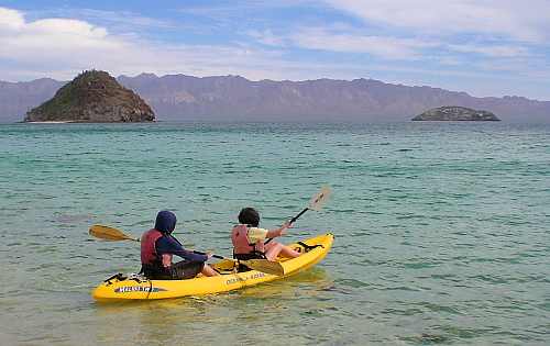
The collapse of the copper mining industry may have caused Santa Rosalía to slip back temporarily into a somnolent slump, but it is now recovering. The mining boom of a hundred and twenty years ago has been replaced by a boom in nature and adventure tourism, which take advantage of the town’s proximity to Conception Bay and the islands in the Sea of Cortés. As we shall see in a future post, because Santa Rosalía has preserved much of its past, it has a massive advantage over its competitors in the region, in that its initial revival fueled by ecotourism can be amplified by cultural or heritage tourism. This beautiful old town and its inhabitants have plenty of reasons to be optimistic as they face up to the challenges of the twenty-first century.

Paddling to an ecotourist future... Photo: Tony Burton

Paddling to an ecotourist future…

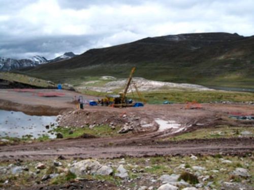
And now, the town has another reason for optimism. The massive El Boleo copper cobalt zinc-manganese deposit, which fueled the town’s first boom period, is now being re-developed with new technology. Baja Mining, based in Canada, owns 70% of El Boleo; a consortium of Korean companies owns the remaining 30%. The 1.2-billion-dollar, open-cast mine will add 3,800 jobs to the local economy. During its anticipated 23-year life span, El Boleo is expected to yield more than 2,000 metric tons of cobalt, 25,000 tons of zinc sulfate and 50,000 tons of copper annually.

Sources:

Want to read more?

Review of “Mexican National Identity, Memory, Innuendo and Popular Culture”, by William H. Beezley

 Books and resources  Comments Off on Review of “Mexican National Identity, Memory, Innuendo and Popular Culture”, by William H. Beezley
Sep 152011
 

William H. Beezley, a professor of history at the University of Arizona, has written widely about Mexican history. He was co-editor, alongside Michael C. Meyer, of the Oxford History of Mexico, an illustrated “narrative chronicle” through the centuries, and a landmark modern history of Mexico. In this book, first published in 2008, Beezley explores the development of Mexican National Identity through a history of some facets of its popular culture.

As in the case of his earlier work (Judas at the Jockey Club and Other Episodes of Porfirian Mexico), Beezley’s Mexican National Identity. Memory, innuendo and popular culture (University of Arizona Press), is wide-ranging and engaging. The book consists of five essays on different themes which Beezley considers central to the development of Mexican National Identity.

In the first chapter, Beezley looks at how the character known as El Negrito came to be “one of the most famous marionettes of nineteenth-century puppet theater”. El Negrito, an Afro-American usually portrayed as a Veracruz cowboy, personified the attitudes of nationalistic Mexicans in the nineteenth century, with his mocking of the French and Maximilian, his temper tantrums, his infidelity, his wit and his resistance to the American invaders.

beezley - coverFrom a geographic perspective, chapter two is the book’s most interesting. The chapter opens by looking at the development of maps which “like symbolic physical features and regional individuals, portrayed Mexico with diversity as the salient attitude”. He describes two 18th century maps, drawn specifically for clerical travelers, highlighting altitude (and therefore climate) and language (ethnicity), but lacking scales, physical features or other landmarks. The modern era of Mexican map-making began with Alexander von Humboldt, and was extended later in the 19th century by others including Antonio García Cubas.

The production of maps necessarily included decisions as to which landmarks, places and features were most important. It also prompted clearer definitions of national boundaries, in both the north and south. In Beezley’s words, “This question of borders had political significance, and both cultural and social dimensions as Mexicans believed the boundaries divided their civilized society from the barbarians beyond.”

Chapter 2 then examines the role of almanacs and lotería (lottery cards), the quintessential Mexican parlor game, in helping to foment national attitudes. Almanacs were “a source of popular or local history and collective memory”. They gave potted summaries of the lives of the saints and martyrs, lists of holy days, images and biographies of political leaders and so on.

Lottery cards shared stereotypical views of objects and characters, often related to local stories. Beezley says that the version played in Campeche eventually gained the greatest popularity. The images used in Campeche formed the basis for the earliest commercially produced sets of cards when Clemente Jacques (a French immigrant and founder of the eponymous food processing brand)  first launched his range of culinary products, from chiles, olive oil and mole sauce to beans, jams and honey, and founded his own printing business to print his own labels. Jacques promoted his brand at the world’s fairs in Chicago (1893) and St. Louis (1904), using printed decks of lotería cards as a form of advertising. His cards became the basis for the modern packs of lotería cards sold throughout Mexico. Many of the most common images have multiple associations, some even including an overtly sexual double meaning. Some figures such as El Borracho (The Drunk) and El Valiente (The Brave One) and La Sirena (The Siren/adultery) are not associated with a particular region or place. Others such as The Scorpion and The Toad are readily associated with specific geographic regions or states: Durango and Guanajuato respectively. Almanacs and lotería cards helped reinforce a sense of national identity while recognizing regional and ethnic differences.

In Chapter 3, Beezley focuses on how celebrations of Mexican Independence gradually came to assume a massive significance for national identity. Independence came in 1821, but it was not until 1869 that annual celebrations of Independence Day really took off. On September 16, 1869, the Mexico City-Puebla railway line was inaugurated, beginning an exciting new era for transportation, which was to have far-reaching effects. During the presidency of Porfirio Díaz, Mexico celebrated its centenary of Independence, an event marked with banquets, parades and the opening to the public of a hastily-restored section of “The Pyramids” at the archaeological site of Teotihuacan. Beezley outlines how the popular perception of Mexico’s patron saint, the Virgin of Guadalupe, changed in less than a century from “the terrifying emblem of Padre Miguel Hidalgo’s insurrection, and the patron of downtrodden, rebellious Mexicans, to the patron saint of the dictatorship’s elite.”

Chapter 4 looks at the role of itinerant puppet theater in molding Mexico’s national identity. The largest and most famous single troupe was the Rosete Aranda troupe, formed by two Italian immigrants in 1850. The troupes went from strength to strength in the next half-century. By 1880, the Rosete Aranda company had 1,300 marionettes and by 1900 a staggering 5,104. Their creativity knew few bounds, and by undertaking annual tours around the country, they helped influence opinions and attitudes. Incidentally, their need to undertake annual tours was in keeping with the established principles of central place theory. As described in Geo-Mexico, the same principles apply in the case of traveling circuses.

In the hierarchy of central places, each step up sees a smaller number of places, each providing a wider range of goods and services, and serving a larger market area. This occurs because for a service to be provided efficiently there must be sufficient threshold demand in the central place and its surrounding hinterland to support it. For this reason we do not find new car dealers, heart surgeons or ballet schools in every small village. These activities can only survive in much larger centers where there is sufficient demand. Individual residents are not prepared to travel far in order to access a service of relatively low value. This poses a challenge for services such as puppet shows which are unable to command a high ticket price, but which need large numbers of potential viewers (a large threshold population) if they are to succeed. This quandary can be resolved by moving from one mid-sized center to another throughout the year, gaining access to a new audience in every location.

Needless to say, the invention of modern communications systems such as television means that this is no longer entirely true, except for live performances.

Beezley’s entertaining romp through Mexican popular culture and its links to national identity is well worth reading. It may not discuss all aspects of how Mexico’s national identity developed during the 19th century, but it provides numerous valuable insights into how a country of such diversity gradually acquired a clearer sense of national identity and purpose.

Where to buy:

Mexican National Identity. Memory, innuendo and popular culture, by William H. Beezley (link is to Sombrero Books’ amazon.com page).

Jul 112011
 

Many Chicano activists refer to Mexicans as “La Raza”, literally “the race”. “Dia de la Raza” is celebrated on Columbus Day (October 12) as the day the Mexican indigenous population started their resistance against the European invasion.

Racial classification in colonial times

Racial classification in colonial times (Click to enlarge)

The term “La Raza” derives from a 1948 book “La Raza Cósmica.” The author Jose Vasconcelos’ thesis is that Mexicans (who he defines as a combination of indigenous and European bloodlines) are a new superior race. In developing his thesis, Vasconcelos draws upon many concepts including Marxism; he felt Europeans were too materialistic and capitalistic. He suggested that Mexicans have evolved (à la Darwin) into a new race that would be a world leader in the years ahead. The Government of Mexico tacitly agreed with this approach which engendered national pride. It was also consistent with the government’s post Mexican Revolution view that all ethnic groups should be combined into a common Mexican national identity.

According to the 2010 census, about 15% consider themselves indigenous, though about 58% of these do not speak any indigenous language. Assuming the “white” and “other” categories are still about 10% and 2% respectively, this suggests that today about 73% are mestizos. Almost all people in Mexico refer to themselves simply as “Mexicans”, not as indigenous Mexicans or mestizos or whites.

Vasconcelos’ “Raza Cósmica” and most Mexicans overlook the historical fact that Mexicans have an important African heritage. Between 100,000 to 200,000 African slaves were brought into Mexico during the 16th through 18th centuries, nearly a quarter the number brought to the USA. In 1646 there were 35,000 African slaves in Mexico, more than 2.5 times the white population [see Blacks outnumbered Spaniards in Mexico until after 1810]. These slaves represented about 12% of the total population, roughly equal to the percentage of slaves in the USA before 1860.

Mexico’s second president, Vicente Guerrero, whose mother was partially Black, abolished slavery in 1829. Thousands of Blacks moved into Mexico from the USA before it abolished slavery in 1865. However, today there are very very few black faces in Mexico. One can spend weeks in Mexico’s major cities without seeing a Black Mexican. If one pays close attention, they can identify people of African heritage in a few selected communities in Veracruz and along the Costa Chica in Guerrero and Oaxaca [Bobby Vaughn’s homepage: Afro-Mexicans of Costa Chica ].

What happened to all the Blacks in Mexico?  [Blacks in Mexico] In a word they assimilated by having offspring with other racial groups. In colonial times, the Catholic Church went to great lengths to categorize intermixed races for marital and baptism purposes:

The terminology for racial mixes

Complex terminology for racial mixes

Before too long, nobody could keep all the combinations straight! Eventually, everyone of mixed race was considered a mestizo. The African portion was purposely or accidentally dropped.

Modern research, based on DNA, indicates that Mexican mestizos are genetically about one-eighth African [mtDNA Affinities of the Peoples of North-Central Mexico]. While Brazil is often identified as the world’s foremost melting pot, the evidence suggests that in Mexico the races have melted more than in any other country.

While there are very few black faces in Mexico, there is a great deal of African heritage represented in art, music, dance, food, and even in fishing and agricultural practices. Did you know that the popular Mexican song “La Bamba” recorded by Richie Valens, Los Lobos and others can be traced back to the Bamba district of Angola? As part of the 500th anniversary of Columbus’ famous voyage, the Government of Mexico finally acknowledged officially that Africa was Mexico’s “Third Root”.

Mexico’s role in the birth control revolution

 Other  Comments Off on Mexico’s role in the birth control revolution
Jun 212011
 

The oral contraceptive pill, often referred to simply as “the Pill” will be officially sixty years old on October 15, 2011. In the words of The Economist: it “was arguably the first lifestyle drug to control a normal bodily function—fertility—rather than a dread disorder. It transformed the lives of millions and helped reshape the role of medicine in reproduction.” Its social impact was massive, helping to foment the sexual and feminist revolutions.

From a geographic perspective, the Pill coincided with ever-increasing concern about the rate of world population growth, and its impact on resources –  the start of an era which led to such seminal works as The Population Bomb and The Limits of Growth.

Initially, the development of the Pill was met by medical, religious and social furor, much of which has since subsided. Even though its popularity has declined since the 1960s, because of concerns about possible side effects, it is estimated that it is still used, in one form or another, by more than 80 million women worldwide.

Curiously, the synthetic female sex hormone called norethindrone was first synthesized from, believe it or not… Mexican-grown yams!

Equally interestingly, the Pill was not developed in a huge laboratory belonging to a major pharmaceutical company but in a relatively humble laboratory in Mexico City, belonging to a small company called Syntex. Syntex specialized in making steroids from Mexican yams, using methods of synthesis invented by a maverick biochemist, Russell Marker. Marker had published various studies on diosgenin, a saponin isolated from a Mexican yam species of the genus Dioscorea, and had discovered how to synthesize the human hormone testosterone and progesterone from diosgenin. After having his proposals for the large-scale production of human steroids from diosgenin turned down by U.S. pharmaceutical companies, Marker moved to Mexico and began his own, home-based, small scale production. This was so successful that a new company, Syntex, was soon born, specifically to make steroids from Mexican yams. Syntex quickly became the world’s largest producer of progesterone, as well as making testosterone and the female hormone esterone.

Enter Carl Djerassi. Djerassi was an Austrian-born chemist who had completed his PhD at the University of Wisconsin (1945) by researching the synthesis and transformation of steroids, including sex hormones. After working four years as a research chemist with CIBA Pharmaceutical Co. in Summit, New Jersey, he decided on a strategic move, in 1949, to join Syntex, in Mexico City, as associate director of chemical research.

At Syntex, Djerassi set out to see if diosgenin could be made to yield other steroids, which do not actually exist in nature, but which retain the biological activities of progesterone and are also orally active. The original aim of his team was to develop a drug for infertility and menstrual disorders that could be swallowed, as opposed to injected. Only two years later, on October 15, 1951, the group led by the then 28-year-old Djerassi, had synthesized norethindrone, a “super-potent orally active progestational agent”, which turned out to be the key ingredient in The Pill. (Chemically, norethindrone is 17a-ethinyl-19-nortestosterone; its generic name in Europe is norethisterone).

Later, the drug’s ability to suppress ovulation was demonstrated by Gregory Pingus at the Worcester Foundation in Massachusetts and clinical trials began. The rest, as they say, is history!

Djerassi is Emeritus Professor of Chemistry at Stanford University with an extremely distinguished scientific record, holding no fewer than 19 honorary doctorates in addition to numerous other honors. He is also one of only a handful of American scientists to have been awarded both the National Medal of Science (1973, for the first synthesis of a steroid contraceptive, The Pill) and the National Medal of Technology (1991, for promoting new approaches to insect control).

In medicinal chemistry he will be forever associated with the initial developments in the fields of oral contraceptives (Norethindrone), antihistamines (Pyribenzamine) and topical corticosteroids (Synalar).

They say that the well-rounded man combines scientific inquiry with artistic appreciation, and Djerassi is certainly no exception, having turned, in later life, to science fiction writing, examining the human side of scientists and the personal conflicts they face in their quest for knowledge, personal recognition, and financial rewards. One of his plays, “An Immaculate Misconception,” premiered in 1998 at the Edinburgh Fringe Festival and has since been performed in London, San Francisco, Sweden, Vienna and Cologne. It was also broadcast on BBC World Service Radio in May 2000.

Sources:

The idea for this post originated from a review in The Economist (October 13, 2001) of two books: Sexual Chemistry: A History of the Contraceptive Pill (Lara Marks, Yale) and This Man’s Pill. Reflections on the 50th Birthday of the Pill. (Carl Djerassi, Oxford University Press).

Several chapters of Geo-Mexico: the geography and dynamics of modern Mexico discuss Mexico’s population dynamics and trends, and their implications for future development. An earlier post here links to a pdf file showing Mexico’s population pyramid in 1990, and the predicted pyramid for 2050.

How did Mexico get to be the world’s 11th most populous country?

 Other  Comments Off on How did Mexico get to be the world’s 11th most populous country?
Jun 112011
 

Mexico is currently the world’s 11th most populous country. While it has not always held this position, Mexico has been among the world’s population leaders for the last two thousand years. Worldmapper.org provides data on the estimated population occupying the areas of current countries for various years starting in the year one, when India (62 million) and China (60 million) had more than half of world’s total population of 231 million. No other country had more than eight million. Mexico ranked 17th with an estimated two million inhabitants. According to available data eight countries have always been more populous than Mexico: China, India, Bangladesh, Russia, Pakistan, Japan and Indonesia.

The next data point is the year 1500, when Mexico ranked 13th with an estimated population of seven million. This estimate seems reasonable, though some feel that Mexico’s population might have been as large as 15 million which would have made Mexico the third most populous country on the planet behind only China and India. Between year 1 and 1500, Mexico surpassed Turkey, Spain, Egypt, Iran, and the Ukraine; but was passed by Germany.

Mexico’s total population plunged after the Spanish arrived bringing small pox, other diseases and major social disruption. By 1600, Mexico’s population was down to 2.5 million, but it was still the most populous country in the New World, according to data provided by gapminder.org. It ranked 22nd tied with Austria and behind such countries as Czechoslovakia, Poland, Sudan, and Yugoslavia.

In 1700 Mexico’s population was 4.5 million, ranking it 18th. By 1820 the USA had moved past Mexico’s population of 6.6 million to become the most populous country in the New World. Mexico maintained its 19th ranking until 1870 when Brazil surpassed Mexico’s population of 9.2 million to become the most populous country in Latin America. It is interesting that there were relatively few changes in the ranks of the top 20 countries during the 170 year period between 1700 and 1870, except for the USA which went from 40th to 4th.

Since 1870 Mexico’s population has surpassed that of nine different European countries. By 1900 Mexico had 11.7 million inhabitants moving it past Czechoslovakia and Turkey into the 18th spot. (Note that Gapminder population figures are higher than the Mexican census figures, perhaps because they attempted to correct for census under-counting; for the purposes of this analysis we use the Gapminder figures.) Mexico maintained its 18th rank until 1950 when its population of 28.5 million edged it past Spain and war torn Poland into 16th place. In 1970 its population reached 52.8 million putting Mexico in 14th place ahead of France and the Ukraine. By 1980 Mexico’s population of 68.3 million pushed it past Italy and Britain into 12th place. A decade later its population of 84.9 million moved Mexico past Germany into the 11th spot, where it has remained.

What will happen in future decades? Mexico’s position will change, but only slightly. In 2020, Mexico’s population may reach 125 million moving it past Japan into 10th place (Population forecasts for 2020 to 2050 are from the U.S. Bureau of Census). By 2030, Mexico, with a population of about 135 million, will have passed Russia, but fallen behind Ethiopia and the Philippines, putting it back in the 11th spot.

Mexico’s estimated population of 144 million in 2050 will place it 12th behind the Congo (World Population Prospects: the 2010 Revision). According to the United Nations, by 2100 Mexico’s population will decrease to 127 million moving it to the 20th spot, behind Tanzania, Uganda, Kenya, Iraq, Zambia, Niger, Malawi, and Sudan. Obviously, the accuracy of such a long term forecasts is very speculative. For example, given global climate change and possible food scarcities, some doubt if the sub-Saharan African countries can grow as rapidly during the last half of the 21st century as projected by the United Nations.

Review of Jeffrey M. Pilcher’s “¡Que vivan los tamales! Food and the making of Mexican Identity”

 Books and resources  Comments Off on Review of Jeffrey M. Pilcher’s “¡Que vivan los tamales! Food and the making of Mexican Identity”
Jun 022011
 

Are you interested in the geography of Mexico’s regional cuisines or the historical relationships between food preparation methods and gender roles in Mexican society? If so, add ¡Que vivan los tamales! Food and the making of Mexican Identity by Jeffrey Pilcher to your “Books Wanted” list.

Pilcher’s lively and entertaining account analyzes how the history of food in Mexico has been intimately tied to the country’s evolving national identity. The connections have become widely recognized, so much so that UNESCO recently conferred Intangible Cultural Heritage status on traditional Mexican cuisine, especially that of the state of Michoacán.

Pilcher cover of Que Vivan Los TamalesIn every chapter, Pilcher delves into the details. He explains how Mexico’s elites strongly preferred dishes based on wheat (first introduced into Mexico by early colonists) to those based on corn, one of Mexico’s many contributions to world cuisine. Indeed, they went so far as to argue that, across the globe, societies based on corn or rice would never rise above those based on wheat.

True appreciation of Mexico’s indigenous foods developed only slowly, mirroring the gradual development of nationalism, before coming to be considered a key component of the national identity. The advent of the railways in the 19th century allowed exotic foodstuffs to be marketed throughout the country for the first time. National cookbooks began to appear, highlighting the distinctive dishes of different regions, a trend continued to the present-day.

Technological developments have brought many changes. With industrialization, the time-consuming preparation of traditional corn tortillas was gradually superseded, especially in urban environments, by machine-made tortillas, whose taste is considered by connoisseurs to be greatly inferior to that of their hand-made equivalents, now increasingly restricted to relatively remote rural areas. Each step in the industrialization of tortillas brought massive social changes. Traditionally, the production of tortillas was the preserve of womenfolk, one of their numerous daily household chores. When mechanized tortilla presses were introduced, the making of tortillas quickly became an acceptable occupation for men. Freedom from the arduous work involved in making tortillas daily from scratch allowed women time to pursue other activities and to enter the formal workforce.

Gender, race, social class, dietary preferences, the fusion of indigenous cuisine and techniques with ingredients and methods imported from Europe and elsewhere… all are explored in this fascinating book.

Mexico’s cuisine is justly famous for its extraordinary regional variety; in just a few decades, the essential ingredients for Mexican food have become global commodities, appearing on supermarket shelves in dozens of countries around the world. Pilcher’s book puts this success in context, making it an essential read for anyone interested in the geography and history of Mexican cuisine.

Details (link is to amazon.com): ¡Que vivan los tamales! Food and the making of Mexican Identity by Jeffrey M. Pilcher (University of New Mexico Press, 1998).

Related posts:

For more about Mexican cuisine, visit the amazing award-winning blog Mexico Cooks! and also browse the huge selection of recipes, articles and tips about all aspects of Mexcan food and cooking in the “Cuisine” section of MexConnect. ¡Buen provecho!

The Battle of Puebla is re-enacted each year on Cinco de Mayo (May 5), but in Mexico City

 Other  Comments Off on The Battle of Puebla is re-enacted each year on Cinco de Mayo (May 5), but in Mexico City
May 052011
 

The Mexican holiday of Cinco de Mayo (5 May) commemorates the Battle of Puebla, fought on May 5, 1862. Puebla is a major city about 100km east of Mexico City, on the historically important route to the port of Veracruz.

In 2012, to mark the 150th Anniversary of the Battle of Puebla, a major re-enactment of the Battle was held in Puebla, attended by the President and many cabinet members and officials. A commemorative bi-metallic 10-peso coin was also issued to commemorate this anniversary.

Since the 1930s, a re-enactment of the Battle of Puebla has been held each year at Peñón de los Baños, a rocky outcrop close to Mexico City’s international airport. Of geographical and geological interest, the rocky outcrop of Peñón de los Baños was formerly an island in the middle of Lake Texcoco. The prominent landmark was visited by Alexander von Humboldt when he toured parts of Mexico in 1803-4. Among other things, Humboldt analyzed the chemical composition of its thermal springs, thought to have curative and medicinal properties.

The re-enactment of the Battle of Puebla at Peñón de los Baños attracts tourists, history buffs, and Mexico City residents looking for an unusual experience.

Re-enactment of Battle of Puebla.

Re-enactment of Battle of Puebla. Photo credit: Jose Carlo González (La Jornada)

In an earlier post, we noted that the Cinco de Mayo holiday is less celebrated in Mexico these days than in the USA:

Celebrations of 5 May in the USA date back to the third quarter of the nineteenth century (only a few years after the Battle in 1862), though they gained prominence only after the 1950s and 60s when major Mexican beer makers associated their brands with Cinco de Mayo celebrations north of the border.

Mexican beer may be one of the country’s most important exports but, as the annual re-enactment in Peñón de los Baños shows,  the commemorations of Cinco de Mayo still held on Mexican soil are far more authentic.

Cultural adaptation: the Cinco de Mayo holiday is far more widely celebrated in the USA than in Mexico

 Other  Comments Off on Cultural adaptation: the Cinco de Mayo holiday is far more widely celebrated in the USA than in Mexico
May 022011
 

The Mexican holiday of Cinco de Mayo (5 May) commemorates the Battle of Puebla, fought on May 5, 1862. The battle marks Mexico’s best-known military success since its independence from Spain in 1821.

Today, in a curious example of cultural adaptation, the resulting holiday is celebrated far more widely in the USA than in Mexico.

The background to the Battle of Puebla

The nineteenth century in Mexico was a time of repeated interventions by foreign powers, including France, Spain, Britain and the USA, all of which hatched or carried out plans to invade.

US stamp for Cinco de MayoThe first French invasion, in 1838, the so‑called Pastry War, lasted only a few days. A decade later, US troops entered Mexico City, and Mexico was forced to cede Texas, New Mexico and (Upper) California, an area of 2 million square kilometers, about half of all Mexican territory, in exchange for 15 million pesos.

A new constitution in 1857 provoked an internal conflict, known as the Reform War (1858‑60), between the liberals led by Benito Juárez, who supported the new constitution, and the conservatives. The War decimated the country’s labor force, reduced economic development and cost a small fortune. Both sides had serious financial problems. At one point in this war, the liberals reached an agreement with the USA to be paid four million pesos in exchange for which the USA would receive the “right of traffic” across the Isthmus of Tehuantepec “in perpetuity”. Fortunately, this treaty was never ratified by the US Senate.

The financial crisis deepened, eventually leading Mexico to suspend all payments on its foreign debt for two years. The vote was approved by the Mexican Congress by a single vote. The foreign powers involved were furious; in 1861, Britain, France and Spain decided on joint action to seize the port of Veracruz on Mexico’s Gulf coast and force Mexico’s government to pay. The UK and Spain quickly agreed terms and withdrew their military forces, but the French decided to stay.

The French are confident of victory

France’s emperor, Napoleon III (Louis Napoleon Bonaparte) had grand ambitions and envisaged a Mexican monarchy. To this end, he decided to place Austrian archduke Maximilian von Habsburg as his puppet on the Mexican throne. The French Army moved inland from Veracruz and occupied the city of Orizaba. The French commander was supremely confident that his forces could crush any opposition. (Following their defeat at Waterloo in 1815, no-one had beaten the French in almost fifty years.) The Commander, Charles Ferdinand Latrille, the Count of Lorencez, confidently boasted that, “We are so superior to the Mexicans in race, organization, morality and devoted sentiments that I beg your Excellency [the Minster of War] to inform the Emperor that as the head of 6,000 soldiers I am already master of Mexico.”  (Quoted in “Betterment for Whom? The Reform Period: 1855‑1875” by Paul Vanderwood, chapter 12 of The Oxford History of Mexico (edited by Michael C. Meyer and William H Beezley, O.U.P. 2000).

Mexican resistance

Marching towards Mexico City, the French needed to secure Puebla, which was defended by 4,000 or so ill‑equipped Mexican soldiers. Ironically, given the eventual outcome, many of the defenders were armed with antiquated weapons that had already beaten the French at Waterloo, before being purchased in 1825 by Mexico’s ambassador to London at a knock-down price! The Mexican forces, the Ejército de Oriente (Army of the East) were commanded by General Ignacio Zaragoza, a Texas‑born Mexican. Zaragoza dug his forces into defensive positions centered on the twin forts of Loreto and Guadalupe.

The events of 5/05

On the 5 May 1862, Zaragoza ordered his commanders to repel the invaders at all costs. Mexicans received unexpected help from the weather. After launching a brief artillery bombardment, the French discovered that the ground had become so muddy from heavy unseasonable downpours that maneuvering their heavy weapons was next to impossible.

Painting of Battle of Puebla

Bullets rained down on them from the Mexican troops that occupied the higher ground near the forts. At noon, the French commander ordered his troops to charge the center of the Mexican lines. But the lines held strong, and musket fire began to take its toll. Successive French attacks were rebuffed. The Mexican forces then counter‑attacked, spurred on by well-organized cavalry, led by Porfirio Díaz who would subsequently become President of Mexico.

As the afternoon wore on, and the smoke began to clear, it became apparent that the defenders of Puebla had successfully repelled the European invaders. The French troops fled back to Orizaba before retreating back to the coast to regroup. A crack European army had been soundly defeated by a motley collection of machete‑wielding peasants from the war‑torn republic of Mexico….

A few days later, on 9 May, President Benito Juárez declared that the Cinco de Mayo would henceforth be a national holiday.

Aftermath: the French return with reinforcements

Back in Paris, Napoleon was enraged. He ordered massive reinforcements and sent a 27,000-strong force of French military might to Mexico. This strengthened French army (under Marshal Elie Forey) took Mexico City in 1863, forcing Benito Juárez and his supporters to flee. Juárez established himself in Paso del Norte (now El Paso) on the US border, from where he continued to orchestrate resistance to the French presence. Supported by the conservatives, Maximilian finally ascended to the throne in May 1864. By this time, in the USA, the Unionists had taken Vicksburg, and the US government was considering its position. In May 1865, General Philip Sheridan led 50,000 US soldiers to ensure that French troops did not cross the Mexico‑USA border. Diplomatic pressure for a French withdrawal intensified and Napoleon III finally agreed to remove his troops in February 1866.

After the French had departed, President Juárez reestablished Republican government in Mexico, and put Maximilian on trial, ending an extraordinary period in Mexican history.

The significance of 5/05

With the passing of time, the Cinco de Mayo has assumed added significance because it marks the last time that any overseas power was the aggressor on North American soil.

In Mexico, the Cinco de Mayo is still celebrated with lengthy parades in the state and city of Puebla, and in neighboring states like Veracruz. There is at least one street named Cinco de Mayo in almost every town and city throughout the country.

In the USA, the Cinco de Mayo has been transformed into a much more popular cultural event, and one where many of the revelers think it commemorates Mexican Independence, not a battle. (Mexico’s Independence celebrations are in mid-September each year).

Many communities in the USA, especially the Hispanic communities, use Cinco de Mayo as the perfect excuse to celebrate everything Mexican, from drinks, music and dancing, to food, crafts and customs. The Cinco de Mayo has become not just another day in the calendar, but a very significant commercial event, one now celebrated with much greater fervor north of the border than south of the border.

Where to go to see more — Texas

General Ignacio Zaragoza died on September 8, 1862, only a few months after the Battle of Puebla. In 1960, the General Zaragoza State Historic Site was established in his birthplace, near Goliad, Texas, to commemorate his famous victory. In Zaragoza’s time, the town was known as La Bahía del Espíritu Santo.

Where to go to see more — Puebla

The Guadalupe and Loreto forts are in parkland, about 2 km north‑east of Puebla city center. The Fuerte de Guadalupe is ruined. The Fuerte de Loreto became state property in 1930. It is now a museum, the Museum of No Intervention (Museo de la No Intervención), complete with toy soldiers. The park has an equestrian statue of General Zaragoza and is the setting for the Centro Civico 5 de Mayo, with its modern museums, including the Regional Museum (history and anthropology), the Natural History Museum and the Planetarium (IMAX screen).

Review of “Climate and Society in Colonial Mexico: A Study in Vulnerability” (Georgina Endfield)

 Books and resources  Comments Off on Review of “Climate and Society in Colonial Mexico: A Study in Vulnerability” (Georgina Endfield)
Apr 052011
 

Environmental historian Georgina Endfield has analyzed a wide variety of colonial archives to explore the complex relationships between climate and social and economic systems. Her book—Climate and Society in Colonial Mexico: A Study in Vulnerability—considers case studies in three distinct zones of Mexico:

  • the arid Conchos Basin of Chihuahua
  • the fertile Oaxaca Valley
  • the agricultural area centered on Guanajuato in the Bajío region

Endfield - Cover of Climate and Society in Colonial MexicoEndfield systematically unravels the connections between climatic vulnerability and the ways in which societies sought to mitigate the impacts of climate-related disasters, while striving for greater resilience against similar events in the future. Her book considers a range of disasters and impacts, from floods, droughts and storms to epidemics, food shortages, riots and rebellions.

The author captures her readers immediately as she describes how “28 June 1692 was a very wet day in Celaya, Guanajuato. Unusually heavy rains began falling in the afternoon and continued all through the evening.” This was the prelude to “terrible panic among all the inhabitants of the city”, and “could not have come at a worse time”, since two years of drought and crop blights had led to famines and epidemics.

Throughout the book’s seven chapters, Endfield writes in a direct manner. She avoids lengthy quotes in favor of presenting a carefully constructed argument, as she leads the reader in an exploration of the content and merits of the colonial sources. In the final chapter, she examines the broader context, relating climatic events in Mexico to events in Europe, and considering the possible role of ENSO (El Niño Southern Oscillation) events.

An extended table towards the end of the book provides a time line for the known environmental hazard events striking the three areas between 1690 and 1820. It shows, for example, that droughts were reported in Chihuahua in no fewer than 40 years of that 130-year time span.

Referencing throughout the book is meticulous, and repeated use is made easier by the provision of a detailed index.

I do have one tiny quibble. The use of accents in this book is quite inconsistent. Even for place names, some accents are missing, while others have migrated to the wrong letter. For example, Léon is often used for León.

This is a fascinating read. Apart from the many invaluable examples of climatic hazards and their demographic, social, economic and political impacts, Endfield has been hugely successful in demonstrating the tremendous value of Mexico’s rich colonial archives, archives which no doubt still hold many more secrets, which they will only give up in response to similarly painstaking research.

Studies of climate change are set to take center-stage in coming decades, and this historical account reminds us all that climate hazards are far from a rare or a novel occurrence.

In short, this is a highly recommendable book.

Details (click for amazon.com):

Climate and Society in Colonial Mexico: A Study in Vulnerability (Blackwell, 2008) by Georgina H. Endfield; 235 pages.

Mexico’s diverse climates and climatic vulnerability are the subject of chapter 4 of Geo-Mexico: the geography and dynamics of modern Mexico. Water availability, rivers, aquifers, water issues and hazards are analyzed in chapters 6 and 7. Buy your copy today!

Mexico’s pearl collection industry: from boom to bust in less than 100 years

 Other  Comments Off on Mexico’s pearl collection industry: from boom to bust in less than 100 years
Mar 282011
 

In a previous post, we looked at the early history of pearl collecting in Mexico. In this post, we carry the history forward to the present-day.

The search for oyster shells with pearls inside was revolutionized after 1874 when larger vessels, equipped with diving suits and accompanying equipment, first entered Mexican waters. The newer methods permitted access to shells in much deeper water, and lengthened the season, greatly increasing the industry’s productivity. The dangers associated with pearl hunting changed. Equipment failures and lax supervision cost many lives. According to Kunz and Stevenson, divers confined to diving suits for hours at a time frequently suffered rheumatism, paralysis (due to compression and sudden temperature changes) and partial deafness. On the other hand, diving suits reduced shark attacks.

The conditions in Baja California were so favorable for pearling that by 1889, within a few years of its incorporation, the Compañía Perlífera de la Baja California (based in La Paz, and employing about 900 men) had come to completely dominate the world pearling industry. One of the largest pearls found in the Sea of Cortés was one weighing 372 grains found near Mulegé in 1884. On arrival in Paris, its value was estimated at 85,000 francs (about 16 600 dollars at the exchange rate of the time). A 400-grain pearl, found in the same area, now forms part of the Spanish crown jewels.

A 1903 article in The New York Times says that the Baja pearl industry had produced more than two million dollars worth of pearls in 1902, including some of the “finest jewels of this kind found anywhere in the world”. The article describes several individual pearls, and emphasizes that the area is “noted for its fancy pearls – that is to say, the colored and especially the black ones”. As mentioned earlier, the native Indians wore fire-blackened pearls. This seems to have been a particularly prescient choice, given the extremely high premiums long placed on natural black pearls. Even today, at least one firm in Baja specializes in producing cultured black pearls from rainbow-lipped oysters.

As the twentieth century progressed, cultured and artificial pearls were able to out-compete natural pearls in terms of price and availability. By 1936, a century of rampant overfishing of oyster beds had depleted natural stocks to the point where recovery was unlikely. Finding fifteen to twenty small pearls required the harvesting of a ton of oyster shells. To cap it off, an unknown disease then spread rapidly through the remaining oysters, virtually wiping them out.

poster for steinbeck's "the pearl"

By the time the American writer John Steinbeck arrived in Baja in 1941, the glory days of Mexican pearling were over. While in La Paz, Steinbeck came across a legendary (and cautionary) local tale about the greed associated with finding a massive pearl. The story became the catalyst for his novella “The Pearl“, published in 1947, in which Kino, an impoverished pearl diver, finds a huge pearl, “The Pearl of the World” which promises to transform his life. It does, but not in the way one might expect. Kino becomes a brutal sociopath; the story, which was later turned into a movie starring Pedro Armendáriz and María Elena Marquéz, becomes a dark tale of the costs of defying traditional customs.

Today, very few natural pearls are harvested in the Sea of Cortés, but several Baja California firms cultivate pearls, helping to extend a centuries-old industry into the present. It is especially appropriate, therefore, that the city of La Paz, once the center of the world’s pearling industry, is still known, even today, as the “Pearl of the Sea of Cortés”.

Sources / Further reading:

  • Anon. Important Pearl Fisheries on the Coast of California. The New York Times, June 14, 1903.
  • Hardy, R. W. H. 1829 Travels in the Interior of Mexico in 1825, 1826, 1827 and 1828. London: Henry Colburn & Richard Bentley. Reprinted in 1977, Texas: Rio Grande Classics.
  • Kunz, G. F., and Stevenson, C. H. The Book of the Pearl: Its History, Art, Science and Industry. Dover. 2001.
  • Landman, Neil H and Mikkelsen, P. Pearls: A Natural History (Harry N. Abrams, 2001)
  • Mayo, C. M. Miraculous Air: Journey of a Thousand Miles through Baja California, the Other Mexico. Milkweed Editions. 2007.

This post is an edited version of the original article which appeared on MexConnect.

Mexico’s long romance with pearls began way before the arrival of Spanish explorers

 Other  Comments Off on Mexico’s long romance with pearls began way before the arrival of Spanish explorers
Mar 192011
 

This post highlights the pearl, the beautiful birthstone associated with the month of June. Few people realize that Mexico was once the world’s major source of pearls.

The history of pearl collecting in Mexico goes back a very long way. When Spanish explorers sailed into the Sea of Cortés (Gulf of California) in the early 1530s they encountered Pericú Indians wearing necklaces strung with red berries, shells and blackened pearls. It is believed that pearl jewelry in the region dates back about 7000 years. Lacking metal knives, the only way the Indians could prize open the oyster shells and find pearls was by throwing the shells into a fire, hence the charred pearls. The Spanish explorers quickly recognized that their knives would yield lustrous milky-white pearls, the equal in quality of any found in the Middle East or Asia.

Harvesting pearls became a priority as the Spaniards tried to establish permanent settlements on the arid peninsula now known as Baja California. From 1535 to Mexican independence in 1821, thousands of pearls were dispatched to Europe on a regular basis, where they were incorporated into the lavishly decorated regalia of many notable European courts. During the period of Jesuit missions in Baja (1697 to 1768) pearl collecting was restricted, but even then illegal traffic in pearls persisted.

Cover of Pearls, a natural history

Following Mexico’s independence, other European nations besides Spain sought access to Baja pearls. For instance, English traveler R. W. H. Hardy arrived in Mexico in 1825, to prospect for pearls and coral on behalf of the General Pearl and Coral Fishery Association of London. Hardy was proud of having “travelled over a part of Mexico visited by no other European” and greatly valued the local knowledge of the coastal Indians of north-western Mexico. Unlike most of his contemporaries, Hardy developed a very positive view of the Indians he met, and felt that they had far more to offer outsiders than just the location of natural resources.

The pearling industry in Baja really took off in the mid-nineteenth century as enterprising, business-minded armadores hired native divers (mainly Yaqui Indians from Sonora) to explore the numerous shallow coves between La Paz and Mulegé, and around the islands including Cerralvo and Isla Espíritu Santo. Diving was a seasonal occupation, primarily carried out during the warm months from May to late September. At other times of the year, water temperatures and higher winds made diving difficult or impossible. The Indian divers worked from rustic canoes for up to five hours a day, armed with a short sharpened stick which did double duty, to pry oyster shells off the seabed and to ward off lurking sharks and manta rays. The divers earned a share of the catch, but their rewards were meager and benefits few.

Citing a 1859 paper, Kunz and Stevenson report that by 1857, 95,000 tons of oysters had been removed from the Sea of Cortés, “yielding 2770 pounds of pearls, worth $5,540,000.” Mexico’s high society also lusted after pearls, leading Empress Carlota to remark how the ladies attending a theater event all wore dresses “covered in pearls”.

Mexico’s pearling industry was on the edge of world-wide fame. In a future post, we will see how the introduction of newer technology after 1870 revolutionized pearl collecting in Mexico, bringing a boom that would last well into the twentieth century.

Sources / Further reading:

  • Hardy, R. W. H. 1829 Travels in the Interior of Mexico in 1825, 1826, 1827 and 1828. London: Henry Colburn & Richard Bentley. Reprinted in 1977, Texas: Rio Grande Classics.
  • Kunz, G. F., and Stevenson, C. H. The Book of the Pearl: Its History, Art, Science and Industry. Dover. 2001.
  • Landman, Neil H and Mikkelsen, P. Pearls: A Natural History (Harry N. Abrams, 2001)
  • Mayo, C. M. Miraculous Air: Journey of a Thousand Miles through Baja California, the Other Mexico. Milkweed Editions. 2007.

This post is an edited version of the original article which appeared on MexConnect.

Corn, another of Mexico’s gifts to Thanksgiving

 Other  Comments Off on Corn, another of Mexico’s gifts to Thanksgiving
Nov 232010
 

According to Ernst and Johanna Lehner in their Folklore and Odysseys of Food and Medicinal Plants, corn (which originated in Mexico) was misnamed as Turkish corn at the same time as turkey acquired its name, and for much the same reason. Europeans first saw corn, called maize or mahiz by the indigenous people, when Columbus and his followers arrived in the New World. They took samples back to Spain at the very end of the 15th century.

Turkish corn from Fuchs' De Historia Stirpium; Basle 1542

Turkish corn from Fuchs' De Historia Stirpium; Basle 1542

It quickly became an important crop, successfully cultivated throughout the continent. 16th century herbalists in Europe called the new plant by various names, including Welsh corn, Asiatic corn, Turkish wheat and Turkish corn. The latter name was the most usual, since they believed that the grain had been brought into central Europe from Asia by the Turks, who had introduced dozens of other products from the east into Europe at about the same time.

The Turks themselves called the crop “Egyptian corn”; the Egyptians called it “Syrian sorghum”… The German botanist Hieronymus Bock, in his New Kreüterbuch or herbal in 1546, remained on the fence, calling it “foreign corn”. Given the confused terminology, perhaps it is not surprising that, to quote Ernst and Johanna Lehner, “It took Spanish botanists more than 50 years to convince other European herbalists that corn was American.” Corn was given its botanical name, Zea mays, by Carl von Linné in the 18th century.

Previous posts in the Thanksgiving mini-series:

Geo-Mexico: the geography and dynamics of modern Mexico is your handy reference guide to all aspects of Mexico’s geography Ask your library to acquire several today! Better yet, purchase your own copy…

The geography of Thanksgiving: why a Mexican bird came to be called turkey

 Other  Comments Off on The geography of Thanksgiving: why a Mexican bird came to be called turkey
Nov 222010
 

Geographers who are Hungary like to eat Turkey, provided it does not have too much Greece.

The first in this Thanksgiving series of posts looked at how the first Thanksgiving was actually held in Mexico, and not the USA as more commonly claimed.

Many of the essential ingredients of the modern Thanksgiving feast also originated in Mexico. In this post, we take a look at the origins of the Thanksgiving (and Christmas) turkey.

How did the turkey eaten at Thanksgiving and Christmas acquire the same name as a European country? Or was it the other way around?

Modern day turkeys (the edible kind) are the direct descendants of the wild turkeys (Meleagris gallopavo) still found in many parts of Mexico.

Wild Turkey, Meleagris gallopavo Painting by John James Audubon, 1830

Wild Turkey, Meleagris gallopavo. Painting by John James Audubon, 1830

So, how is it possible that a Mexican bird acquired the name turkey? The most likely explanation derives from the fact that the merchants who traded in the Middle Ages between the Middle East and England were based in the Turkish Empire and hence known as “Turkey merchants”. Turkey merchants are also believed to have introduced the guinea fowl, a native of Madagascar, to European dinner tables.

Later, the larger New World bird, the present-day turkey, was brought back to Spain by the conquistadors. The rearing of New World birds gradually spread to other parts of Europe and North Africa. The Turkey merchants capitalized on the new opportunity, and began to supply the new birds instead of the guinea fowls to the English market, and the rest is history.

The first use in English of the word “turkey” to describe the bird dates back to 1555. By 1575 , turkey was already becoming the preferred main course for Christmas dinner. Curiously, the Turkish name for the turkey is hindi, which is probably derived from “chicken of India”, perhaps based on the then-common misconception that Columbus had reached the Indies.

Mexico’s wild turkeys had been domesticated by pre-Columbian Indian groups long before the Spanish conquistadors arrived. Several archaeological sites provide tantalizing clues as to precisely how turkeys were reared. One such site is Casas Grandes in the northern state of Chihuahua, an area where modern, large-scale turkey-rearing is still an important contributor to the local economy.

Previous posts in the Thanksgiving mini-series:

Geo-Mexico: the geography and dynamics of modern Mexico is your handy reference guide to all aspects of Mexico’s geography. If you have enjoyed this post, please consider gifting a copy of Geo-Mexico to someone this holiday season.

Nov 212010
 

If you live anywhere near Plimoth Plantation, Massachusetts, you may wish to stop reading right now…

For the benefit of our many non-US readers, Plimoth Plantation, Massachusetts is commonly cited as the “birthplace of Thanksgiving”. The first  Thanksgiving is said to have been held there way back in 1621.

Well, has Geo-Mexico got news for you

Several years ago, Don Adams and Teresa Kendrick wrote a compelling account of how the very first Thanksgiving celebration held by Europeans in North America was actually held on April 30, 1598.This is fully 23 years earlier than Plimoth Plantation.

From our Geo-Mexico perspective, even more important is the fact that they provide ample evidence to prove that this very first Thanksgiving was not held in the USA at all, but actually took place  in New Spain (Mexico)! So, Thanksgiving is actually of Mexican origin. Before we know it, the USA will be claiming tacos, tequila, and mariachis as well…

Incidentally, one curious feature of the original 1598 feast is that it apparently did not include either turkey or potatoes! We will continue this mini-series on the geography of Thanksgiving next time.

Happy Thanksgiving!

Geo-Mexico: the geography and dynamics of modern Mexico is your handy reference guide to all aspects of Mexico’s geography. If you have enjoyed this post, please consider gifting a copy of Geo-Mexico to your friends in the coming holiday season.