Diana Kennedy and regional cuisines in Mexico

 Other  Comments Off on Diana Kennedy and regional cuisines in Mexico
Aug 302014
 

Diana Kennedy is the world’s foremost authority on regional Mexican cuisines. Born in the UK, she moved to Mexico in 1957 with her husband, Paul Kennedy, a New York Times correspondent. Over the next half a century, Kennedy traveled the length and breadth of Mexico, collecting stories, cooking techniques and recipes, and writing about regional cuisines from all over the country.

kennedy-cuisines-of-mexicoHer first cookbook The Cuisines of Mexico was published in 1972 and quickly became a classic. She has written several other books about Mexican cuisine, including

Now in her nineties, Kennedy continues to live in an eco-friendly house in s small village near the city of Zitácuaro in the western Mexico state of Michoacán. The Mexican government awarded her the Aztec Eagle, Mexico’s highest award for non-Mexicans, for her truly outstanding contribution to the country.

In this recent BBC radio podcast, Diana Kennedy is interviewed about her lifetime’s work, including the thousands of hours spent driving along dusty dirt tracks in her pick up truck in search of yet another unrecorded gem of Mexican cuisine.

Her travels often took her to indigenous villages, way off the beaten track, where she would study how and what the local people cooked, discovering along the way, all kinds of things never previously written about.

Podcast (mp3 file) of BBC Radio 4 Food Programme about Diana Kennedy :


The initial leads for the next trip often came from the maids of friends in Mexico City, maids who were prepared to share their family recipe secrets with her.

Kennedy documented varieties of corn and beans that are rapidly disappearing, as are the small family farms where they were grown. In most locations, she would start by exploring the local market. Marveling over the incredible fresh produce she encountered wherever she traveled, she recorded every detail; sadly, some of these markets have long since disappeared.

The “Mexican miracle” of the 1960s and 1970s, with its growing economic prosperity brought a tide of imported foods into Mexico. These reached deep into the countryside. In many places, traditional foods were forgotten, replaced by imported items such as wheat bread and pork chops.

Dietary changes have continued to plague Mexico, leading to a dramatic increase in obesity. Note, though, that despite the claims made on this BBC program, Mexico does not yet lead the world in obesity – though it is the fourth most obese country in the world (excluding small island states). Clearly, BBC researchers should read Geo-Mexico more often.

Kennedy’s 1972 book, The Cuisines of Mexico was a ground-breaking look at the regional world of food in Mexico. UNAM, Mexico’s National University, is keeping Kennedy’s work alive by making digital copies of all her notebooks, some of which date back to the 1950s.

For more about Mexican cuisine, visit the amazing award-winning blog Mexico Cooks! and also browse the huge selection of recipes, articles and tips about all aspects of Mexican food and cooking in the “Cuisine” section of MexConnect. ¡Buen provecho!

Related posts:

How can tourism perception be assessed? A case study using the Lerma-Chapala drainage basin

 Books and resources, Teaching ideas  Comments Off on How can tourism perception be assessed? A case study using the Lerma-Chapala drainage basin
Aug 282014
 

In numerous previous posts, we have looked at the importance of tourism in Mexico, and have examined its impacts at different scales, from the national/international scale at one extreme to the single resort scale at the other:

National scale:

Sub-national regional scale:

Single resort scale

We have also considered the way in which the characteristics of tourism in a resort change over time:

Attempting to quantify the importance or impacts of tourism, beneficial or otherwise, is fraught with methodological difficulties. The number of hotel rooms in different cities is often used as a proxy measure of the relative importance of tourism in different communities, but looking only at tourist capacity “masks  the fact that hotels are rarely full. In 2007, the national occupancy rate was 54.8%. Traditional beach resorts such as Acapulco, Mazatlán and Puerto Vallarta had an occupancy rate of 52.2%, compared to 68.1% for modern, planned mega-resorts like Cancún and Los Cabos. The occupancy rate in the large cities—Guadalajara, Mexico City and Monterrey—was 55.0%, well ahead of the 47.2% for other interior cities.” (Geo-Mexico, p 134).

As in other branches of geography, it is not only the “reality” that matters, but also people’s perceptions of reality. Most decisions concerning location (such as where to live, the best place to start a new business. etc) are taken on imperfect or incomplete information; in other words, these decisions are based, at least to some extent, on perceptions.

In the case of tourism, it is the perception of visitors that matters. This is precisely why certain resorts gain a reputation as being “jet set” or the “in place” to vacation. The “in place” today is not going to be the “in place” in a few year’s time, since perceptions (and reality) change. Nowhere has this proved to be more true in Mexico than in the case of Acapulco.

But is it possible to measure tourist perceptions? It is very difficult to do so directly, but there are ways of tackling this question, and here we look at one approach, based on an analysis of tourist-oriented literature.

The approach is easiest to explain in the context of a real example, in this case an analysis of the likely perception of foreign tourists of destinations in the Lerma-Chapala drainage basin in Mexico. (This study formed part of my contribution on tourism to the Atlas de la cuenca Lerma-Chapala, construyendo una visión conjunta, Semarnat-Unam-IE, 2006 – the link is to a low-resolution pdf of the entire atlas).

The Lerma-Chapala Basin (see map) is one of Mexico’s major river systems, comprising portions of 127 municipalities in five states: México, Querétaro, Michoacán, Guanajuato and Jalisco. The basin has considerable economic importance. It occupies only 2.9% of Mexico’s total landmass, but is home to 9.3% of Mexico’s total population, and its economic activities account for 11.5% of national GDP. It also has considerable importance for tourism.

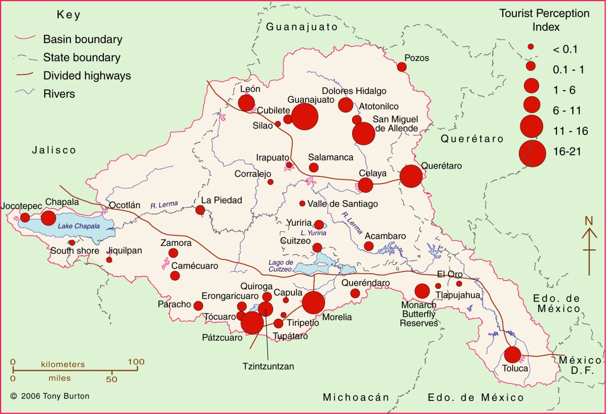
Lerma Basin Tourist Perception Index.

Lerma Basin Tourist Perception Index. Cartography: Tony Burton / Geo-Mexico; all rights reserved Click to enlarge.

The red circles superimposed on the map represent an index of tourism perception. This index is based on an analysis of seven tourist guides that purport to cover the entire country:

  • AAA Tourbook (2004)
  • Let’s Go Mexico (2004)
  • Lonely Planet (2002)
  • Footprint Guide (1999)
  • Upclose Mexico (1998)
  • Insight Guide (1994)
  • Cadogan Guide (1991)

In each case, the total number of lines of text in the guide devoted to any location within the Lerma-Chapala drainage basin was counted, as well as the number of lines devoted to each individual location. This allowed a ratio or percentage to be worked out for each place for each book. For example, if a book had 240 lines in total devoted to the drainage basin, of which 60 were devoted to San Miguel de Allende, the perception index for San Miguel for that book would be 60/240 * 100 = 25%. Similar calculations were performed for all the locations mentioned, for each book, and then the mean index was calculated for each location. These mean indices were the basis for the size of the circles on the map.

In broad terms, the map shows which places are likely to be on a foreign traveler’s radar when they are visiting the area. Those familiar with this area may be surprised to see that the ghost town of Pozos merits as many lines of text as Quiroga (and indeed more lines of text than Atotonilco). Another surprise is that Tzintzuntzan appears to be as much in the tourist eye as Chapala, Dolores Hidalgo or Toluca. The main purpose of this post is not to analyse such apparent anomalies but only to suggest a relatively easy way of analysing tourist perceptions through the use of tourist-oriented literature. Applying the same method to the entire country, on a state-by-state basis, throws up far more interesting anomalies which we plan to share at some point in the future.

Related posts:

Related posts:

Recent progress in waste water treatment in Mexico

 Mexico's geography in the Press  Comments Off on Recent progress in waste water treatment in Mexico
Aug 252014
 

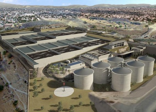
Two wastewater treatment plants have been in the news recently. The first is the $230 million Agua Prieta wastewater treatment plant, located north of Guadalajara in Jalisco, which was formally inaugurated last month. It is the first stage in a plan to restore the heavily polluted Santiago River back to health. The Santiago is the outflow from Lake Chapala and receives pollutants from the industrial zone of El Salto outside Guadalajara. The initial capacity of the Agua Prieta plant is 6,500 liters/second, almost all of which is returned to the river after treatment.

The plant was built by a consortium led by ICA subsidiary Conoisa, Atlatec, and Servicios de Agua Trident under a 20-year concession. President Enrique Peña Nieto claims on his government webpage that, “Integrated, sustainable water management is a government priority. The challenge is even greater because almost 50% of the wastewater returned to the environment does not undergo any form of treatment… The Agua Prieta Wastewater Treatment Plant in Zapopan… [will] improve the quality of life of 3.3 million inhabitants in the metropolitan area of Guadalajara… It will treat 82% of the wastewater in the area, and 100% when the complementary sewage works are completed.”

agua-prieta-wastewater-According to government figures, waste water treatment coverage at the national level is currently 50.3%, with a 2018 target of 63%. Agua Prieta has raised national coverage to 53.3%, and will boost it to 54.3% once the plant is operating at full capacity and treating 8,500 liters/second of wastewater. At the state level, Jalisco is now treating 32% of its wastewater.

The Agua Prieta plant is currently the largest of its kind in Mexico and is powered by biogas derived from the wastewater sludge. However, an even larger plant is under construction, in the state of Hidalgo in central Mexico. The Atotonilco Wastewater Treatment Plant is being built by a consortium, including Mexican construction companies ICA and IDEAL, Mitsui subsidiary Atlatec and Spanish firm Acciona Agua, that won the concession to design, build, and operate this plant for 22 years, at which point the plant will be transferred to federal ownership. Work began in 2010 and is due to be completed by 2015.

The Atotonilco Wastewater Treatment Plant will be the largest wastewater plant in Latin America and one of the largest in the world, with a biological treatment capacity of 23,000 liters/second (1.99 million m3/day). The wastewater treatment is performed by a series of conventional processes, with an additional chemical process during the rainy season. Treated waters from this plant are already being used in agriculture without any additional cleaning steps. The plant is self-sufficient in terms of energy usage, since it converts the methane offgas from the wastewater sludge into electrical energy.

Related posts:

Aug 232014
 

Mangrove swamps have an undeserved reputation for being impenetrable thickets harboring noxious insects and reptiles. But they also have considerable value, in terms of both ecology and economics, as this case study of the Marismas Nacionales mangroves on the west coast of Mexico will demonstrate.

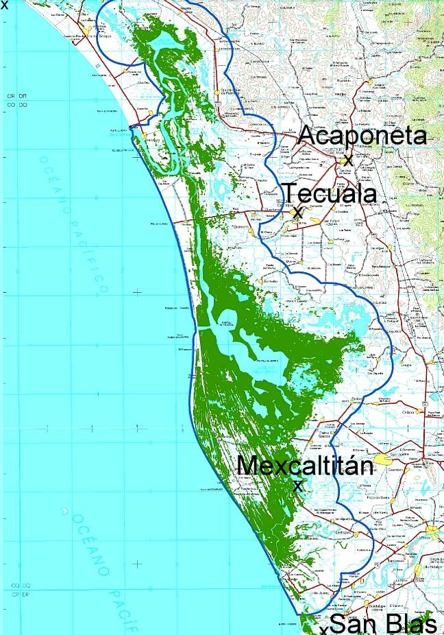
Map showing location of Marismas Nacionales

Map showing location of Marismas Nacionales

The Teacapán-Agua Brava-Marismas Nacionales Lagoon System extends northwards along Mexico’s Pacific Coast from San Blas in Nayarit to the southern part of Sinaloa. It is one of Mexico’s largest areas of mangroves. The total area of mangroves in the Marismas Nacionales is estimated at 58,100 hectares (224.3 square miles). Four species of mangroves are found here:

  • black mangrove (Avicennia germinans)
  • white mangrove (Laguncularia racemosa)
  • red mangrove (Rhizophora mangle)
  • button mangrove (Conocarpus erectus)

Mangroves in Mexico are estimated to be disappearing at a rate of at least 2% per year, though the available evidence suggests that the Marismas Nacionales mangroves are relatively undisturbed.

A 2012 study, undertaken by a group of Stanford Students for the Ocean Innovations Environmental Defense Fund considered the ecosystem services provided by Mexico’s largest area of mangroves, the Teacapán-Agua Brava-Marismas Nacionales Lagoon System of Nayarit and southern Sinaloa and attempted to calculate the mangroves’ carbon sequestration potential.

The ecosystem services considered included:

  • fisheries for shrimp, mollusk, fish and crustaceans.,
  • aquaculture (primarily shrimp), forestry (charcoal, firewood, wood and roofing materials),
  • agriculture,
  • coastal protection (mangrove roots help bind unstable coasts, preventing erosion and providing a natural barrier against hurricanes),
  • habitat for other species (breeding, shelter and feeding places for fish, crustaceans and birds) and
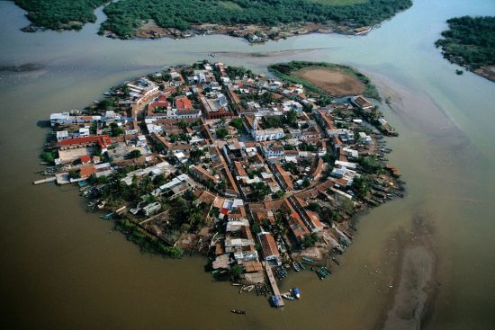
  • ecotourism (as in Mexcaltitán)
Mezcatitlán

Mezcatitlán, island settlement in Nayarit

The report tries to quantify the value of each of these services. For example, it finds that the total annual revenue brought in by coastal fisheries alone around Marismas Nacionales (including shrimp, catfish, crabs and sharks) almost certainly exceeds $10.8 million.

In terms of carbon storage, the study took into account the carbon sequestered in the form of biomass (as a result of photosynthesis) as well as the carbon exported from the ecosystem via processes such as respiration, sediment burial and mineralization. The total Net Ecosystem Production (NEP) of carbon in the Marismas Nacionales was calculated to be 8 metric tons of carbon/ha/yr or about 470,000 metric tons/yr for the entire area.

Reference:

  • Marismas Nacionales Conservation & Carbon Sequestration Study. Preliminary Report (pdf file)

Related posts:


Mexico’s “little sea cow” on the verge of extinction

 Other  Comments Off on Mexico’s “little sea cow” on the verge of extinction
Aug 202014
 

Wildlife groups from around the world are urging the Mexican government to take urgent action to prevent the extinction of the “little sea cow”, the world’s smallest porpoise, known in Spanish as the vaquita marina, currently the most endangered cetacean in the world.

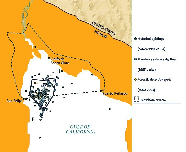
This particular porpoise is only found in the upper sections of the Sea of Cortés (Gulf of California), and fewer than 100 are thought to exist.

Scientists say that gill-net fishing must be eliminated in the little sea cow’s native habitat for its population to have any hope of recovering to a sustainable level. Mature females will usually only give birth to one calf every two years. Even with a total ban, it would therefore take several years for natural increase to boost the population. In the port of El Golfo de Santa Clara studies have suggested that gillnet fishing is responsible for approximately 39 vaquita deaths a year.

Map of sightings and acoustic detection spots. Adapted from North American Conservation Action Plan for the vaquita

Map of sightings and acoustic detection spots. Adapted from North American Conservation Action Plan for the vaquita

According to Jo Tuckman, writing in The Guardian, environmental groups blame the decline of the popoise population on a “booming illegal trade in the totoaba fish (mistakenly called “toboada” in The Guardian), driven by Chinese demand for its swim bladder, which is believed to have medicinal properties.” Chinese fishermen are alleged to have overfished a similar fish in their own waters, leading to a sharp increase in demand for imports of totoaba. Fishermen in the Sea of Cortés are reported to have been offered more than $4,000 for the single bladder (which weighs 500 grams) of a mature fish.

There have been numerous reported instances of illegal cross-border trade in totoaba bladders, including, Man Admits to Smuggling Swim Bladders of Endangered Fish. The fish has been listed as “endangered” since 1979 under the U.S. Endangered Species Act. Between February and May 2013, border inspectors in Calexico, Arizona, seized the swim bladders of more than 500 endangered Totoaba.

In 2008, Mexico, the USA and Canada launched the North American Conservation Action Plan (NACAP) for the vaquita, under the jurisdiction of the Commission for Environmental Cooperation (CEC), a NAFTA environmental organization. Mexico has also established a program known as PACE-VAQUITA, which compensates fishermen who choose one of three alternatives to commercial fishing: rent-out (payments to avoid fishing in specific areas which are known to have resident vaquitas), switch-out (compensation and inducement to switch technology to vaquita-safe methods), and buy-out (compensation for permanently relinquishing their fishing permits and gear).

Clearly, these efforts have not yet paid off and more stringent controls and enforcement are desperately needed if the vaquita marina is to be brought back from the brink of extinction.

Update (31 December 2014):

“The Mexican federal government has recently proposed a US $37 million compensation plan that would ban gillnet fishing in waters inhabited by the world’s most endangered mammal species.” (Mexico News Daily, 27 Dec 2014)

Want to read more?

Related posts:

Aug 162014
 

Tourism associated with rivers and lakes

So far as tourism is concerned, Lake Chapala is far more important than the other bodies of water within the basin. Only limited recreational activities are practiced in the various man-made reservoirs and in lakes Yuriria and Cuitzeo. Tourism is locally important in Zirahuén the most pristine of the basins lakes, but its small area restricts development prospects. Tourism, including ecotourism, is also locally important in Lake Pátzcuaro, with pronounced seasonal peaks corresponding to school vacations and the annual Night of the Dead. Surprisingly, there are no specialized ecotourism services at Lake Chapala.
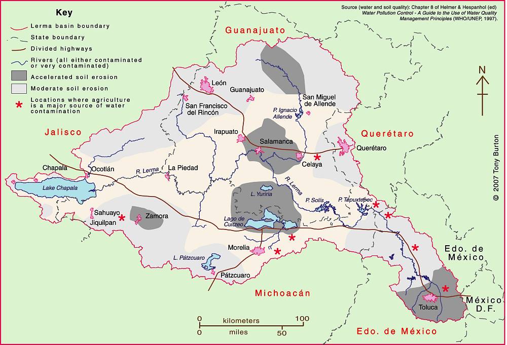
Lerma-Chapala Basin

Lerma-Chapala Basin. Cartography: Tony Burton/Geo-Mexico; all rights reserved

The map shows areas of soil degradation in the Lerma-Chapala basin, as well as the locations where agriculture is a major source of water contamination. The environmental impacts of tourism in the basin are concentrated in the major cities such as Guanajuato, San Miguel de Allende and León, as well as in the smaller communities where tourism is of particular importance, such as Chapala and Pátzcuaro.

The lakes in the basin, especially Chapala, have always had more significance than the rivers for recreation and tourism activities. In the nineteenth century, sail canoes plied the waters of Lake Chapala. Fluctuating lake levels since the 1950s have prevented any concerted effort to establish modern water sports (yachting, water-skiing, windsurfing) on the lake, though casual users can be seen sporadically, mainly at weekends and during school holidays. Recreational fishing is virtually non-existent in the basin. Boatmen and fishermen often have conflicting demands.

Potential for ecotourism

Environmental degradation throughout the basin has reduced the number of potential ecotourism locations. The few remaining natural habitats are in urgent need of effective conservation. None of the few small areas of the basin currently protected at a federal level is associated directly with the River Lerma or Lake Chapala. Several tourism hot spots are under extreme pressure, operating at close to carrying capacity (defined as the maximum number of visitors they can handle without adverse environmental impacts). They include the Monarch butterfly reserves, Lake Camécuaro National Park, and the island of Janitzio in Lake Pátzcuaro. Well managed tourism could help finance habitat restoration and protection. Successful planning will require considerable local participation.

Lovers of flora and fauna want to see native and endemic species, rather than imported exotics. Bird-watching is one of the fastest growing recreational activities in the U.S., a huge niche tourism market in a wildlife watching industry worth 10 billion dollars in North America (Stap, 2002). In the basin, bird-watchers have the opportunity to see several endemics, as well as spectacular flocks of the White Pelican (Pelecanus erythrorhynchos), which can be better viewed on the relatively undeveloped southern shore of Lake Chapala than in its breeding grounds far to the north.

The development of horse-back riding, hiking and walking trails holds considerable potential for the future. Niche markets, such as cultural, shopping and eco-tours could all be further developed. Most tourists prefer a mix of experiences; the basin offers numerous, varied tourism possibilities.

Historically, hunting was an important activity in certain areas, particularly in the marshes at the eastern end of Lake Chapala (the ciénega). One ecological issue here, aside from any need to manage wildlife numbers, is the gradual decomposition of the lead-rich cartridges used a century ago. While this needs further study, this is gradually leaching lead into the environment, but is not the only source of the elevated levels of lead that have been reported in fish and lirio samples (Jay & Ford in Hansen & Van Afferden, 127). Careful monitoring is needed to ensure that no health risk is posed to humans.

Tourism exacerbates existing demands for limited supplies of water. This needs to be recognized in tourist-oriented cities such as San Miguel de Allende, Guanajuato and Pátzcuaro. Some recreational and tourism developments are more water demanding than others. Large expanses of grass cause high losses of water through evapo-transpiration especially during the dry season when watering is needed if grass is to be kept green. However, in the rainy season, grass promotes higher infiltration rates, enhancing groundwater recharge. Pressure from public and private gardens for water could be significantly reduced by xeriscaping.

Management is also needed to ensure that chemicals used in gardens, hotel grounds, and hotels do not cause pollution. The misuse of fertilizers and pesticides can have serious deleterious environmental effects. Overfertilization, for example, can increase nitrogen and phosphorus loads on watercourses, promoting eutrophication.

Golf can be one of the least environmentally sound of all recreational activities (Elkington & Hailes 1992). Constructing a golf course may involve habitat destruction and loss of wildlife; its maintenance may require copious quantities of water and agro-chemicals. A single course may use 330,000 cubic meters of water a year, as much as 4,500 people (Walsh, 2004) Aside from the ethical issue of whether water should be allocated to the playgrounds of the rich while the poor go without, golf courses can greatly reduce water consumption with careful design and management. Of Mexico’s 200+ golf courses, at least 23 are located in the basin. Several were built in the past twenty years. Several others are still in the planning stages. More golf courses may attract more retirees and tourists, but decision makers need to consider the possible social and environmental effects of constructing more courses.

References:

  • Hansen, Anne M. & van Afferden, Manfred (ed). The Lerma-Lake Chapala Watershed: Evaluation and Management. New York: Kluwer Academic / Plenum Publishers. 2001.
  • Elkington, John & Julia Hailes. Holidays that don’t cost the earth. The guide to greener holidays. London: Victor Gollancz Ltd. 1992.
  • Stap, Don. “Great Florida Birding Trail” in Audubon Magazine September, 2002.
  • Walsh, J. “War over water”. Golf Course News, October 2004. G.I.Media. 2004

Source:

This post is based on my contribution (on tourism) to the Atlas de la cuenca Lerma-Chapala, construyendo una visión conjunta, published by Semarnat-UNAM-IE, Mexico, in 2006. (The link is to a low-resolution pdf of the entire atlas).

Related posts:

Where are Mexico’s mangrove swamps?

 Updates to Geo-Mexico  Comments Off on Where are Mexico’s mangrove swamps?
Aug 142014
 

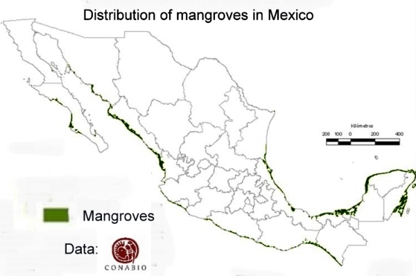
The National Commission for the Knowledge and Use of Biodiversity (Comisión Nacional para el Conocimiento y Uso de la Biodiversidad, CONABIO), has identified 81 distinct areas in Mexico that have mangroves with “biological significance and in need of varying degrees of ecological rehabilitation” (see summary map). These regions are distributed as follows:

  • 10 on the northern Pacific Coast
  • 6 on the central Pacific Coast
  • 13 on the southern Pacific Coast
  • 27 on the Gulf of Mexico and
  • 25 on the Yucatán Peninsula.

A national inventory has now been compiled by CONABIO. All areas have been surveyed and preliminary descriptions published including details of their location, size, physical characteristics, socioeconomic conditions, local uses of mangrove, biological details, including vegetation structure, and an assessment of local impacts and risks, management and existing conservation measures.

Map of distribution of mangroves in MexicoThe areas of mangroves have been mapped at a scale of 1:50,000 and satellite photos from 2005-2006 have been used in conjunction with fieldwork to calculate the areas of mangroves. The final map is believed to be more than 90% accurate, a reasonable baseline for future comparisons. CONABIO is planning to resurvey the mangrove areas every 5 years following the same methodology.

According to preliminary comparisons with previous attempts to quantify the extent of mangroves in Mexico (the subject of a future post), the loss of mangroves was greatest in the period 1970-1980, and in 2000-2005, but then diminished in the period 2005-2010.

Between 2005 and 2010, the states where mangrove loss remained high (as a percentage of the total area of mangroves in the state) included Chiapas, Baja Californa Sur and Sonora. However, the states losing the largest areas of mangroves in absolute terms were Quintana Roo, Campeche and Nayarit. Jalisco has the unfortunate distinction of being the state where coastal mangrove loss was highest (in terms of the proportion of its total coastline length bordered by mangroves).

Related posts:

Aug 112014
 

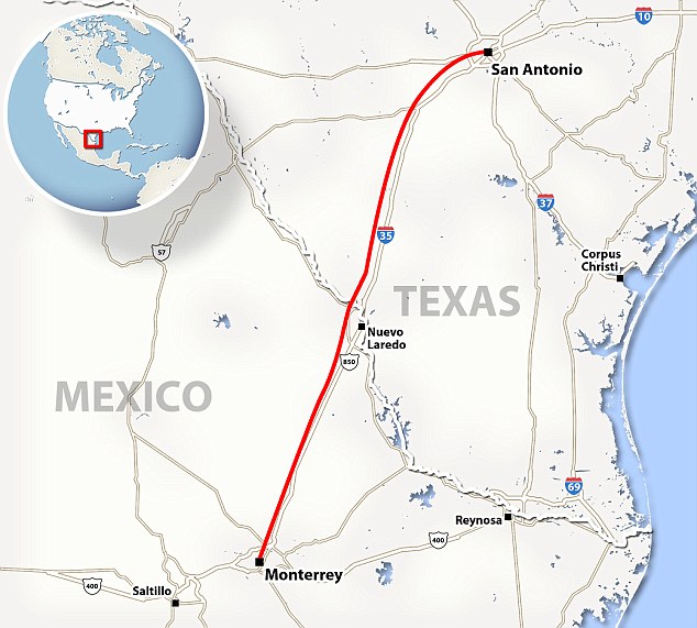
Earlier this year, a slew of press reports discussed the possibility of a Mexico-USA high speed rail link from the industrial powerhouse of Monterrey in Nuevo León state to San Antonio in Texas. (For one example, see Fast train to Monterrey on the horizon).

The reports say that Mexican transport officials and their U.S. counterparts believe that this international high speed rail link could be in operation within a decade. The new line would move passengers between the two cities in about two hours, saving almost three hours compared to highway travel.

Route of proposed high speed train from Monterrey to San Antonio. Credit: Daily Mail.

Route of proposed high speed train from Monterrey to San Antonio. Credit: Daily Mail.

A key part of the plan would be a system to pre-clear U.S. Customs which sometimes delays northbound motorists at border crossings for several hours. (Such a pre-clearance system would be analogous to that already operating in several Canadian airports, where U.S.-bound passengers clear U.S. immigration and customs prior to boarding their flights).

Mexican officials have already secured the rights of way for the rail line from Monterrey to the U.S. border and say that this section of the line, likely to cost around 1.5 billion dollars, could be up and running as early as 2018. The U.S. section, from the border northwards, is unlikely to be completed before 2022 at the earliest, though a $5.6 million study of potential high-speed rail lines stretching from Laredo to Oklahoma City is already underway.

The first high speed rail links in North America are likely to be in Mexico, where planning is well advanced and the first construction contracts are being awarded for building high speed links from Mexico City to Toluca and Querétaro. Plans for a high speed train in the Yucatán Peninsula have also been announced.

For more details of the Mexico City-Toluca high speed rail project, see Plans to improve the Mexico City-Toluca transport corridor.

Want to read more?

Popocatepetl Volcano continues its very active phase

 Mexico's geography in the Press, Other, Updates to Geo-Mexico  Comments Off on Popocatepetl Volcano continues its very active phase
Aug 092014
 

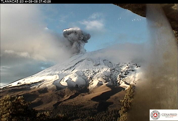
Popocatepetl Volcano, near Mexico City continues to be very active, with smoke and ashes belching up to 1000 meters above the crater rim. Mexico’s National Disaster Prevention Agency Cenapred, reports that the volcano had 82 “low intensity” exhalations on 7 August 2014, four of which contained “explosive material”.

Popocatapetl, 8 August 2014. Credit: Cenapred.

Popocatapetl, 8 August 2014. Credit: Cenapred.

The agency also reported that many mionr tremors hd been recorded, including one harmonic tremor lasting 56 minutes. Geologists believe that the volcano is currently destroying dome number 50 even as dome number 51 begins to form. Dome #51 is currently about 70 meters in diameter. Renewed explosions, together with some ash fall is predicted for the coming days.

The Volcanic Traffic Light remains at Yellow Phase 2.

For a series of images dated 8 August 2014, see Images of 8 of ago of 2014

Related posts:

Day trips and tourism in the Lerma-Chapala basin

 Other  Comments Off on Day trips and tourism in the Lerma-Chapala basin
Aug 072014
 

An earlier post looked at the significant impacts of the estimated 10,000 to 15,000 residential tourists (non-working, non-Mexicans) living part or full-time in the Lerma-Chapala basin. These residential tourists are concentrated in San Miguel de Allende and in the Chapala-Ajijic area on Lake Chapala:

Day trips and regular tourism are also important activities in the Lerma-Chapala basin. Both day trippers and tourists bring economic, social, cultural and environmental benefits, but may also create adverse impacts. Conflicts between tourism and other activities are increasing as demographic and environmental pressures rise.

Day trips

By definition, day trips last less than 24 hours. Most day trips are to a single destination, usually only a relatively short distance from home. Within the Lerma-Chapala basin, certain day trip flows stand out. The strong flow of day-trippers from Guadalajara to Chapala-Ajijic peaks on Saturdays, Sundays and public holidays. Day trippers account for about two-thirds of the total number of visitors to Chapala-Ajijic. Day trip flows linking San Miguel de Allende, Dolores Hidalgo and Guanajuato, and between Morelia and Pátzcuaro are also important. Elsewhere, the Monarch butterfly reserves have seasonal importance as day trip destinations; for example, El Rosario, the most visited reserve, attracts up to 5,000 visitors a day between early December and late March.

Tourism

Tourism, on the other hand, involves overnight stays. A typical tourist trip lasts between 3 and 8 days. Tourism may involve multiple destinations, further away from home. In Mexico, national tourists are more numerous, but, on average, earn less, spend less, and stay a shorter time, than international tourists.

In the Lerma-Chapala basin, tourism began to flourish at the end of the nineteenth century, alongside improvements in transportation, especially the building of railways. The shores of Lake Chapala were an early magnet for the wealthy. Developers redesigned the unplanned fishing villages, attracting visitors from all over Mexico. Even today, the Chapala landscape reflects the historical and cultural influences which have influenced it.

Other parts of the basin also became important tourist destinations. The colonial cities route, taking in San Miguel de Allende, Guanajuato, Morelia, Pátzcuaro and Querétaro, is a prime example, which has been very successfully marketed.

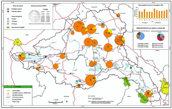
Quantifying tourism in the basin is difficult. Official tourism statistics are based on surveys, but these data have their limitations. The size of the circles on the map below represents the total number of tourists visiting each location in 2005, according to Tourism Secretariat figures. The yellow segment represents the percentage of tourists that are international. atlas-tourist-numbers-2The map shows that tourism is heavily concentrated at a small number of locations close to the boundary of the basin: Morelia, Toluca, Querétaro, San Miguel de Allende, Guanajuato and Chapala-Ajijic. Foreign tourists are particularly important in Toluca, San Miguel de Allende and Chapala-Ajijic. The precise numbers should be treated with caution. Many tourists visiting San Miguel and Chapala-Ajijic (but not Toluca) do not stay in hotels but in “Bed and Breakfasts” or with friends or relatives.

Tourism planning needs to consider strategies which:

  • preserve existing and potential natural attractions and historic sites.
  • increase the number and variety of locations visited by tourists.
  • reduce the pronounced seasonality of existing tourism.
  • increase the average length of stay and expenditure of tourists.

Source:

This post is based on my contribution (on tourism) to the Atlas de la cuenca Lerma-Chapala, construyendo una visión conjunta, published by Semarnat-UNAM-IE, Mexico, in 2006. (The link is to a low-resolution pdf of the entire atlas).

Related posts:

Aug 042014
 

Mabe is one of Mexico’s largest multinational companies (2013 sales: $3.3 billion) with a total workforce of 21,000. The company designs, produces, and distributes domestic appliances (stoves, refrigerators, etc) to more than 70 countries.

mabe-plantThe company was founded in 1946, in Mexico City, by two Spanish immigrants: Egon Mabardi and Francisco Berrondo. It started by making kitchen furniture but quickly added gas ranges and refrigerators. By 1960, Mabe had already become Mexico’s single largest exporter of home appliances.

It continued to expand via an aggressive series of acquisitions, including the purchase of companies in Venezuela, Ecuador, Colombia, Brazil, Peru, Argentina and Canada.

To boost its presence in the USA and Canada, in 1986 Mabe created a joint venture with General Electric to produce appliances for the US market.

mabe-sales

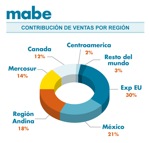
Mabe sales, by region

GE held a 48% minority stake in the new venture and hoped to gain access to Mexico’s low cost labor pool, while Mabe was able to use GE’s existing distribution network to gain wider access to markets throughout the USA. Within a decade, two out of every three gas ranges and refrigerators imported into the USA were designed and manufactured by Mabe in Mexico. Almost all (95%) of the ranges and refrigerators sold as General Electric brands were designed in Mabe’s San Luis Potosi plant, the biggest kitchens plant in the world.

The implementation of NAFTA in 1994 led to further opportunities for Mabe. Since NAFTA, Mexico has become the leading supplier of household appliances, such as stoves, refrigerators, dryers and washing machines to the USA and Canada. In 2005, Mabe continued its expansion by acquiring Canadian firm Camco.

NAFTA also led to the firms competitors, including Whirlpool, Electrolux, Samsung and LG all establishing factories in Mexico.

The company, which is still headquartered in Mexico City, is a major purchaser of steel on the North American market, consuming steel worth around $500,000 each year. Its products include microwaves, washing machines and dryers, wine storage systems, air conditioning, motor-compressors, plastic injection and die-casting machinery.

It has about 15 manufacturing facilities in Latin America. The company’s factories in Mexico –located in Mexico City, Coahuila, Guanajuato, Nuevo León, Querétaro and San Luis Potosí– account for half its total output. In addition, refrigerators and ranges are manufactured in Colombia; freezers, refrigerators and ranges in Ecuador, and refrigerators, washing machines and ranges in Argentina and Brazil.

Mabe’s business practices incorporate a degree of “glocalization” in which the company’s designs are modified to be specific to particular regions, based on the consumer preferences and tastes in each country or region.

In 2014, Mabe announced that it was spending $80 million to repatriate its only Canadian plant from Montreal to Ramos Arizpe, Coahuila. The plant makes washing machines, driers and dishwashers. Together with Mabe’s existing plant in Ramos Arizpe, the two plants have the capacity to turn out about one million washing machines annually.

Related posts:


Quick photo visit to Mexico City

 Other  Comments Off on Quick photo visit to Mexico City
Aug 022014
 

The many stupendous images of Mexico City in “HA!!!, And You Thought We Were Riding Donkeys” on the “Lost in My Little World” blog undoubtedly only portray one side of Mexico City (the nice side), but that does not make them any the less worth viewing.

As the blog’s author puts it, “People are always asking me what living in Mexico City is like. Most people either think its dirt, sombreros and donkeys, or they think that drug dealers and kidnapers are waiting for you to get out of your car to kill you at anytime. None of these speculations are real!! It is one of the greatest cities on earth and this article is here to prove it...”

  • Images of Mexico City

Sadly, the images lack captions, though many of the places are readily identifiable if you have ever visited Mexico’s premier cultural and social center.

Looking for balance? Some of the comments below the images offer links to the many alternative, less attractive sides of the city.