admin

US firms are near-shoring jobs from China to Mexico

 Mexico's geography in the Press, Updates to Geo-Mexico  Comments Off on US firms are near-shoring jobs from China to Mexico
Aug 112011
 

 Near-shoring means “the transfer of business or IT processes to companies in a nearby country, often sharing a border with your own country” (definition from SourcingMag.com). It is closely related to offshoring, now usually limited to similar transfers as near-shoring, but to more distant locations. Among the best examples of near-shoring are the hundreds of US companies that have set up factories and assembly plants in Mexico under the long-running maquiladora program (analyzed in detail in chapter 20 of of Geo-Mexico: the geography and dynamics of modern Mexico).

Maria Elena Rigoli, the President of Collectron International Management Inc., which helps companies make the move from the USA to Mexico, was interviewed about near-shoring for the 20 December 2010 issue of Food Manufacturing News. Despite reflecting her obvious vested interests,  the transcript of the interview is still interesting reading for geographers.

Rigoli first explains how Mexico’s maquiladoras work and then lists the major benefits of moving a company’s operations to Mexico:

  • Extremely fast shipping times offered by such a close location
  • Reduced labor costs
  • Trade agreements with many different countries, including NAFTA
  • Decades of experience in manufacturing and exporting
  • Highly-skilled, well-educated workforce

Quotes from the interview:

“Mexico is one of the world’s five largest developing economies. Global market research firm EuroMonitor International forecasts that Mexico will replace Italy as the 10th largest economy in the world within the next decade.”

“The technology used when producing goods in [Mexico’s] maquilas is the same or superior to that in the United States, as technology is typically transferred by the contracted companies individually. Additionally, the large pool of educated technicians coming out of Mexico’s many technical universities are trained to assemble, package, test and manufacture products in a maquiladora setting. This training is either on par or above the average training manufacturing personnel receive north of the border.”

“The growth of Mexico’s share in the aerospace industry speaks volumes about the craftsmanship and quality of products produced in Mexico. Originally, companies like Boeing and Bombardier only outsourced high volume-low tech operations to Mexico, now entire fuselages are designed and built here.”

How do Rigoli’s claims match up to what is happening today?

Well, among the numerous press reports that US manufacturers have started ‘near-shoring’ work from Asia to Mexico, is this one in Asian Shipper., that quotes figures from a survey conducted by consultancy AlixPartners of 80 big US companies.

The survey found that:

  • 9% have already shifted some or all of their operations from Asia to the Americas (= near-shoring).
  • 33% are considering doing it in the next three years

Is Mexico the most attractive location for near-shoring?

  • 63% say, “Yes!”
  • 19% think the USA is better.

What are the major advantages of near-shoring?

  • 30% said lower freight costs
  • 25% said speed-to-market
  • 18% claimed lower inventory costs
  • 16% said time-zone advantages such as easier management coordination
  • 11% liked closer cultural ties with North American managers.

What started as a trickle of US firms moving manufacturing back from China to Mexico seems to be becoming a clear trend. Globalization may have expanded the reach of many such US firms, but near-shoring now seems to be pulling some of them back, closer to home.

Related posts:
The Transnational Metropolitan Areas of Mexico-USA

 Other  Comments Off on The Transnational Metropolitan Areas of Mexico-USA
Aug 092011
 

Mexico shares a 3,169 km (1,969 miles) border with the USA. This is one of the most heavily guarded and frequently patrolled  land borders in the world, and a rare example of a land border that separates two countries with very different levels of economic development. These differences in development have, of course, prompted many Mexicans to migrate to the USA, either as seasonal or permanent migrants, and whether “legal” or undocumented.

Some regional geographers have even proposed that a regional division of North America should include a distinctive “border region”,  an international region straddling the boundary and including all border crossings and many notable cities. This region experienced rapid economic growth following the signing of NAFTA, when many companies moved to northern Mexico, setting up maquiladora manufacturing plants. The border area has long been a major focus of drugs-smuggling, with border transport of illegal narcotics getting ever more inventive. In recent years, sadly, this same area has become the scene of some of the worst drugs-related violence in the world.

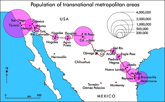
Population of Mexico-USA Transnational Metropolitan Areas.

Population of Mexico-USA Transnational Metropolitan Areas. Credit: Tony Burton; all rights reserved

The map shows the 2010 population of the major transnational metropolitan areas of Mexico-USA. The diameter of each circle represents the combined population of the twin cities that have grown up either side of the border. The pattern closely reflects the volumes of overland transport links (road and rail) between the two countries, as well as of commuters who live one side of the border, but work on the other side and cross daily.

The easternmost part of the boundary between Mexico and the USA follows the Río Bravo (Grande). Inevitably, there have been disputes when the river changed its course. Part of the western boundary follows the course of the Colorado River, from which so much water is taken that it now rarely flows into its delta region in Baja California. All the varied boundary and water-rights treaties and agreements between Mexico and the USA are decided via the International Boundary and Water Commission.

Related posts:

Aug 082011
 

Durango has long been considered the scorpion capital of Mexico (even the local soccer team became known as Los Alacranes, the Scorpions). At one point in the past, the city paid a bounty for each scorpion killed. Some historical accounts suggest that the scorpion catch rose dramatically, until the local authorities realized that some families had started their own financially lucrative scorpion-breeding programs.

These days, few scorpion stings are reported in Durango, partly because Durango’s scorpion hunters (alacraneros) catch and kill thousands each rainy season; prime specimens are encased in souvenir key rings and wall clocks sold in the local market. They also supply medical research labs.  Research in one lab at the University of California has isolated several peptides that appear to suppress the immune system, promising another way to prevent transplant rejection.

Lourival Possani, and his colleagues at Mexico’s National University (UNAM) have discovered a toxin (named scorpine) in scorpion venom that slows down the growth of malaria parasites in fruit flies; if similar techniques work in malarial mosquitoes, it may be possible to dramatically reduce the spread of malaria.

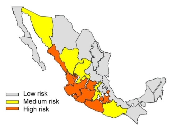
About 250,000 people in Mexico are stung by scorpions each year—more people than in any other country. Several dozen people die each year. Indeed, for the past 20 years, scorpion stings have been the leading reason in Mexico for  deaths due to adverse reactions and poisoning caused by venomous plants and animals. There are more than 200 different species of scorpions in Mexico, of which only 8, all belonging to the genus Centruroides are a significant public health risk. The map shows the areas defined by Mexico’s Health Secretariat as being of High, Medium and Low risk for dangerous scorpions.

Mortality remains higher in the smallest settlements, and is greatly reduced in mid-sized and large settlements. This is a function of both the reduced proximity of medical care in small settlements and of the higher numbers of scorpions/10,000 people in less urbanized settings. The highest mortality rates by age occur in the 0-1 years group (7 deaths/million), followed by the 1-4 age group (3.8/million) and the 60+ years group (0.8/million) (all data from http://www.scielo.br/pdf/rpsp/v21n6/05.pdf)

Scorpion risk in Mexico

Scorpion risk in Mexico (Secretaria de Salud)

Fortunately, progress is being made. The number of recorded deaths from scorpion stings [1] has fallen from more than 1,000/year in the 1950s to 285 in 1995, about 80 in 2003, and 57 in 2005. This improvement is the result of public health campaigns stressing the importance of seeking emergency treatment and of the development of antivenin serum (known as Alacramyn in Mexico and Anascorp in the USA). Mexico’s antivenin industry, led by the Bioclon Institute, is world class, exporting serum to the USA and Australia as well as throughout Latin America. The biggest threat from scorpions comes from central and northern states in Mexico, including several along the Pacific Coast: Nayarit, Jalisco, Colima, Michoacán and Guerrero.

According to UNAM’s Biomedical Investigation Institute, 277,977 people in Mexico reported scorpion stings in 2010. In the first five and a half months of 2011, 98,818 people in Mexico have been stung. The five states with the highest incidence of reported scorpion stings are: Jalisco (19,995), Guerrero (15,769), Morelos (13,123), Guanajuato (12,326) and Michoacán (10,597).

The incidence of scorpion stings rises sharply in summer when higher temperatures encourage scorpions to leave their lairs and go exploring.

Q. What other factors, besides the ones mentioned in this post, might help explain the pattern of risk shown on the map? Hint – can you think of things that the states shown as “high risk” — or the “low risk” ones — have in common?

– – – – –

[1] A Google search using the terms “scorpion”, “deaths” and “Mexico” finds dozens of websites all claiming that “In Mexico, 1000 deaths from scorpion stings occur per year.” This includes the two highest ranking sites in the results here and here, for articles dated 14 April 2011 and 20 August 2009 respectively. Given that 1000 deaths/year from scorpions has not been true for 20+ years, perhaps it’s time for these sites  to update their data by referring to Geo-Mexico!

Aug 062011
 

The 2010 censuses in the USA and Mexico have led to numerous reports on either side of the border. This post looks mainly at recent reports from the Pew Hispanic Center, a project of Pew Research Center, which describes itself as”a nonpartisan ‘fact tank’ that provides information on the issues, attitudes and trends shaping America and the world.”

The total US population in 2010 was 308.7 million. The Pew report entitled U.S. Hispanic Country of Origin Counts for Nation, Top 30 Metropolitan Areas says the the USA had 50.5 million Hispanics in 2010, including 31.8 million of Mexican origin (63% of all Hispanics). [The categories are based on self-described family ancestry or place of birth in response to questions in the 2010 Census and the 2009 American Community Survey.] The population of Mexican-origin grew by 54% (11.2 million) between 2000 and 2010. Mexicans are the dominant Hispanic group in many major metropolitan areas, from Los Angeles to Chicago, and San Antonio to Atlanta, with some exceptions in the East, including Miami (Cubans) and New York (Puerto Ricans).

The report is accompanied by detailed statistical profiles, including Statistical Profile: Hispanics of Mexican Origin in the United States, 2009 that provides a concise summary of all the key data about the Mexican diaspora in the USA.

The Pew Hispanic Center has also updated its interactive maps and database on the USA’s Latino population. Data can be viewed by county for 1980, 1990, 2000 and 2009 and reveal the shifting patterns of residence of the Hispanic population since 1980.

Another Pew report, The Mexican-American Boom: Births Overtake Immigration shows that, since 2000, births have overtaken immigration as the main driver for the dynamic growth of the Mexican population in the USA. This is because:

  • Mexican-Americans are younger (on average) and have higher fertility than other US groups, and
  • The numbers of Mexicans migrating to the USA has fallen. Mexico’s 2010 census revealed that emigration from Mexico to the USA has dropped significantly in recent years, from an average of 480,000/year in 2000—2005 to around 145,000/year for 2005—2010.

Hispanics in the USA lag behind the rest of the population in terms of education. For example, only 9% of Mexicans in the USA aged 25 and over have at least a  Bachelor’s degree, compared with 13% of all Hispanics in the USA and over 20% for the US population as a whole. This is reflected in median earnings, where the average personal earnings for Mexicans in the USA aged 16 and over was $20,000 in 2009, compared to $28.900 for the US population as a whole.

A Presidential Advisory Commission has been formed to look at ways to improve the academic achievement of Hispanics, the largest and fastest-growing minority in the public education system.

The growing number of Hispanics in the USA has meant that Hispanics are now looking to have a greater say in politics. This has led to the formation of the Tequila Party, a nonpartisan movement launched on 5 May (Cinco de Mayo) 2011. Their first political rally, a call to “get out and vote”, accompanied by mariachis, was held in Tucson, Arizona.

Could Southern California’s water woes be eased by a desalination plant in Mexico?

 Mexico's geography in the Press  Comments Off on Could Southern California’s water woes be eased by a desalination plant in Mexico?
Aug 042011
 

Southern California water officials are reportedly considering helping to finance a desalination plant in Mexico as a partial solution to their on-going water issues.

A desalination plant proposed by San Diego County Water Authority and Metropolitan Water District of Southern California, and planned for north of the border in Carlsbad (San Diego County) has been tied up in lawsuits and permitting problems for over a decade. As a result, three states—California, Arizona and Nevada—originally approached Mexico about sharing a desalination plant.

Now, however, the San Diego County Water Authority and Metropolitan Water District of Southern California have proposed a new plant located in Rosarito, Baja California, across the border from San Diego. The plant would have a capacity of 284,000 cubic meters (75 million gallons) of water a day to serve communities on both sides of the border. Construction could begin as early as 2013, at an estimated total cost of $1 billion (one-third of which would be contributed by Mexico).

The proposal has been roundly condemned by several environmental groups, who claim it is an attempt to legitimize the unsustainable usage of water in southern California, while simultaneously destroying marine life off the coast of Baja California.

Related post:

Mexico’s water resources and water-related issues are the subject of chapters 6 and 7 of Geo-Mexico: the geography and dynamics of modern Mexico. Ask your library to buy a copy of this handy reference guide to all aspects of Mexico’s geography today! Better yet, order your own copy…

Mexico’s changing society: the phenomenon of “los ninis”

 Mexico's geography in the Press  Comments Off on Mexico’s changing society: the phenomenon of “los ninis”
Aug 022011
 

Los ninis are young people (aged 15-29) that “ni trabaja, ni estudia” (neither work nor study). They have become the focus of much press attention in the past couple of years, often accompanied by the phrase “Mexico’s lost generation”.

This El Universal article cites Education Ministry (SEP) figures that there are more than 7 million ninis in Mexico, 20.9% of the total number in that age group in the country. Apparently, at present, only five states have any specific programs targeting ninis and trying to persuade some of them either to enter the workforce or resume their education. These five states are Chihuahua, Baja California, Tlaxcala, Guerrero and Hidalgo.

The two states with the highest proportion of ninis (over 25% of the age group) are Chiapas and Michoacán, neither of which has any specific program to help them. The states with the smallest proportion of ninis (about 15% of the age-group) are Colima, Quintana Roo and Yucatán.

It is widely held that, in the absence of help, many ninis will have few options other than to turn to antisocial and criminal behavior, connected to drug trafficking, drug gangs, petty crime and the sex trade.

The state programs that are trying to work with ninis are adopting a variety of strategies, from seeking funding to recruit some ninis into local police forces or offering three-years paid service in the military to providing a direct monetary incentive to continue their education or financial incentives to firms that employ ninis. For example, the state of Chihuahua has funded 2,000 jobs, at a salary of 112 pesos (slightly less than 10 dollars) a day, for such socially-responsible tasks as painting homes in marginal parts of Ciudad Juárez or cleaning parks and public spaces  in Chihuahua city.

It is far too early to say whether these strategies will ultimately be successful. Finding an appropriate and productive role for Mexico’s millions of ninis is likely to remain one of society’s major challenges for decades to come.

Update (17 September 2011):

Mexico’s Secretariats of Education (SE) and of Labor and Social Welfare have issued a joint rebuttal of the previously published figure of 7 million ninis, which apparently originated in an OECD report, not from SE data as originally reported.

The rebuttal claims that 78% of these ninis are young married women, with children, who dedicate themselves to home-making. Up to 1 million young people are in this situation in the State of Mexico alone, the Secretariats claim. They emphasize that the figures reveal a gender inequality in access to educational and economic opportunities, linked to cultural patterns where many young women still see marriage and motherhood as their preferred or only option.

Read more:

The troubled rise of the Green Movement in Mexico

 Other  Comments Off on The troubled rise of the Green Movement in Mexico
Aug 012011
 

Two specific events helped stimulate the rapid growth of Mexico’s green movement in the 1980s:

These motivated many citizens to take direct action. Membership in Environmental Non-Governmental Organizations (ENGOs) surged, as “green brigades” aided the victims. Two months after the earthquake, representatives from 300 regional groups met and formed a coalition of green groups focused on issues such as deforestation, pollution, and opposition to nuclear power. The 1992 Rio UN Environmental Summit and opposition to NAFTA (because it neglected environmental issues) provided additional stimulus to the movement.

The number of ENGOs increased from fewer than 30 in 1985 to about 500 by 1997 when about one in twenty Mexicans was a member of an ENGO.  The ENGOs had highly professional staffs and were well funded from Mexican and international sources. Through demonstrations and militant actions they successfully stopped the construction of a half billion dollar tourism complex south of Mexico City and the proposed world’s largest salt mine in Baja California. They also were significant in the passage of new laws for environmental protection, reducing deforestation, protecting wildlife, and establishing protected areas.

Vicente Fox, the PAN/Green Party candidate, won the Presidency in 2000.  His Minister of the Environment, Víctor Lichtinger, brought scores of highly qualified fellow key ENGO leaders into the administration. While this put the nation’s leading environmentalists on the inside, it also essentially “decapitated” and deflated the ENGO movement, especially its more militant members. Despite these key appointments, Fox’s administration gave relatively low priority to environmental issues. When Fox sided with tourism investors, and decided against issuing a detailed analytical report on beach pollution, Lichtinger and many of his senior staff resigned. They mostly moved to international or academic positions and consequently did not rejuvenate the leadership of the ENGOs they had left.

Green party logo

Green party logo

For the 2006 election, the Green Party formed an alliance with PRI and came in a weak third. The party, which has suffered from despotism, bribery and violation of election laws, managed to elect 22 diputados in the 2009 election. The Calderón Presidency has obtained good environmental marks for its leadership in global warming; however its comprehensive tree-planting program has received some criticism. Current ENGO activity is focused less on high profile mass mobilizations and protests, and more on specific issues such as legislative  lobbying, public awareness, climate change, energy issues, water, deforestation, biodiversity, recycling and local tree=planting and clean-up campaigns.

Main source: Jordi Díez, “The Rise and Fall of Mexico’s Green Movement”, European Review of Latin American and Caribbean Studies 85, October 2008, 81-99.

Mexico’s environmental issues are analyzed in many chapters of Geo-Mexico: the geography and dynamics of modern Mexico, including chapter 30. Explore the book using Amazon.com’s Look Inside feature and buy your copy today!

Jul 302011
 

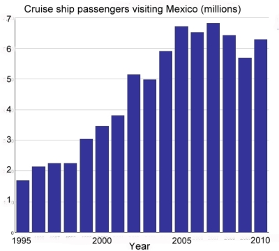
According to data from Mexico’s Tourism Secretariat, the number of cruise ship passengers peaked in 2007, but has since declined, although their average spending has increased. The graph shows the number of passengers arriving on cruise ships to Mexican ports since 1995. This segment of Mexico’s tourism industry grew rapidly between 1995 and 2005.

Cruise ship passengers, 1995-2010

The peak year was 2007 when 6.814 million cruise ship passengers visited Mexico. This was also the year when President Felipe Calderón announced the start of Mexico’s “war against drug cartels”. Since that date, more than 35,000 people have lost their lives in drug-related violence.

The dramatic decline in cruise ship passengers between 2008 and 2009 can be largely attributed to the A-H1N1 flu epidemic, which is thought to have started in Mexico and which brought regional falls in tourist numbers. In 2010, cruise ship passenger arrivals showed signs of recovery, though they remained well below the numbers registered in the peak years from 2005 to 2007. In 2011, the provisional first-quarter figures suggest a slight decline from 2010 numbers.

Security concerns are the main reason for the continued drop in cruise ship passengers visiting Mexico. Earlier this year, Princess Cruises, the major international cruise line, canceled all sailings to Puerto Vallarta and Mazatlán until at least the start of next year. Other cruise lines, including Holland America and Carnival, are also reported to be considering schedule cuts.

The only silver lining in this dark cloud is that the average spending of cruise ship passengers has risen, helping to offset the decline in visitor numbers. It is estimated that cruise ship passengers will contribute about 104 million dollars to Mexico’s economy this year, compared to 112 million dollars in 2007. Even so, the average expenditure per passenger remains very low, certainly below $100 a visit. The average figure has risen over the past few years, but preliminary figures for the first quarter of 2011 reveal that it was still only $91.20 per cruise ship passenger.

Resorts receiving cruise ships need to boost this tourist expenditure figure by offering a wider range of on-shore attractions and attracting higher spending from visitors in order to offset any decline in the number of cruise ship passengers visiting the country. In the long run, the cruise ship sector will only recover fully when drug-related violence is reduced and foreigners’ perceptions of the safety of traveling to Mexico improve.

Related posts:

Chapter 19 of Geo-Mexico: the geography and dynamics of modern Mexico focuses on Mexican tourism and development.  Buy your copy today to have a handy reference guide to all major aspects of Mexico’s geography!

Driving in Mexico: is it safe relative to other countries?

 Books and resources  Comments Off on Driving in Mexico: is it safe relative to other countries?
Jul 282011
 

About 24,000 people were killed last year in traffic accidents in Mexico according to Ángel Martínez, Director of the Mexican Traffic Safety Research Center (Spanish acronym CESVI) . In the USA, the number was about 33,000 in 2010. Does this mean that is safer to drive in Mexico than the USA?

The simple answer is “no” because the USA has three times as many people, about ten times as many registered vehicles, and probably drives over ten times as many vehicle-miles as Mexico. Comparing traffic deaths among countries is relatively complicated because the data are often lacking or not comparable.

A large 2009 World Health Organization (WHO) study indicates that traffic deaths are related to numerous factors. Obviously, the number, age, condition and mix of motor vehicles are very important. Two-wheeled motor vehicles can be more dangerous than automobiles, buses or trucks. Furthermore, road quality, traffic infrastructure, laws, and enforcement are major factors. Many countries do not require use of seat belts, helmets or child seats. The training, skill level and behavior of drivers, as well as pedestrians, are also important. Other factors are alcohol use by drivers and pedestrians, as well as the quality and efficiency of emergency medical teams and health care systems.

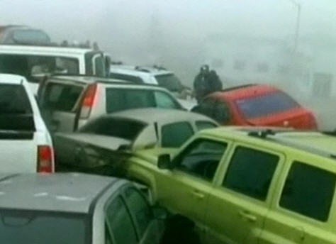
50-vehicle pile-up in fog, Saltillo, January 2011

50-vehicle pile-up in fog, Saltillo, January 2011

According to the WHO study, Mexico ranked 12th in the world in total traffic fatalities. China ranked first with 221,000 deaths per year, followed by India, Nigeria, Pakistan, Indonesia, Russia, Brazil, USA, Egypt, Ethiopia, Iran and then Mexico. Total deaths are related to population, number of vehicles and pedestrians, poor traffic control and emergency medical systems, as well as crowded roads shared by everything from trucks, buses, cars and motor bikes to livestock and pedestrians.

Mexico has about 21 traffic deaths per year per 100,000 population. This is a fairer way to compare countries. On this statistic, Mexico does slightly worse than Brazil (18), China (17), India (17), Indonesia (16), and Thailand (20). Though Mexico is slightly better than Peru (22), Venezuela (22), Russia (25), and Pakistan (25), considerable improvement is needed. President Calderón has set as a goal of reducing traffic deaths by 50% by 2020. Mexico is significantly behind some of the other Western Hemisphere countries such as Canada (9), USA (11), Argentina (14), Colombia (17) and even Guatemala (15).

The major countries with the safest traffic are Japan (5), UK (5), Germany (6), and France (8). The least safe countries are mostly in Africa and include Egypt (42), Ethiopia (35), Kenya (34), Nigeria (32), the Congo (32) and South Africa (33).

Wear your seat belt and drive safely!

From Morelos to Minnesota; case study of a migrant channel between Mexico and USA

 Other  Comments Off on From Morelos to Minnesota; case study of a migrant channel between Mexico and USA
Jul 262011
 

Axochiapan is a town and municipality in the small state of Morelos in central Mexico. According to the 2010 census, the population of Axochiapan municipality has grown only slowly over the past decade, from 30,436 in 2000 to 33,695 inhabitants in 2010, half of them living in the eponymous cabecera municipal (the main town of the municipality).

One of the more curious things about Axochiapan is that three of every ten people born in the municipality now live in the same small area of Minneapolis in Minnesota, USA.

By 2005, the Minneapolis-St.Paul area already had a large Hispanic community, served by 22 churches offering services in Spanish, 9 Spanish-language newspapers, 3 tortilla makers and 9 Hispanic-mostly Mexican-soccer leagues. It even has a Mexican consulate to serve the growing number of Mexican migrants living there. For more details, see:

As many as one-third of the people born in Axochiapan are thought to have moved to “El Norte” (= USA); it is estimated that 90% of all the families in Axochiapan have representatives currently living in Minneapolis-St.Paul.

According to the 2000 census, 41,600 Mexican-born people lived in Minnesota, compared to only 3,500 a decade earlier. By 2010, the figure had risen to about 68,000.

Mercado Central in Minneapolis

Mercado Central in Minneapolis

East Lake Street in Minneapolis has become a center for Mexican commercial activity, from Mexican butchers and video rentals to jewelry making, travel agents and money exchange offices. The hub of Mexican commerce is the Mercado Central, a member-owned cooperative of 48 Latino businesses opened in 1999.

Why do Mexicans migrate here?

  • Population pressure in Mexico – the 15-40-year-age bracket (the main migrant age groups) is still growing in Mexico and will for the next few years.
  • Economics – poor salaries and few job opportunities persist in rural areas of Mexico such as Axochiapan, despite numerous civic improvements, such as the paving of streets, largely financed by remittances sent home by migrants.
  • Networks of migrants provide support and encouragement for relatives and friends, making it far easier for successful migration and adaptation to life in the USA

Is migration from Axochiapan to Minnesota coming to an end?

There is growing evidence that Mexican migration to the USA is slowing down. If this turns out to be the case, it is probably a combination of the poor US economic performance in recent years, the relative strength of Mexico’s economy during that time, and the increased costs associated with entering the USA as an undocumented worker. In addition, US migration policy seems to be encouraging undocumented workers to remain, rather than return home periodically.

Conclusion? Migration flows such as this one, from Morelos to Minnesota, may currently be weakening, but it is far too early to say whether or not this decline will last for very long.

Related posts:

Migration between Mexico and the USA is the focus of chapter 25 of Geo-Mexico: the geography and dynamics of modern Mexico. Ask your library to buy a copy of this handy reference guide to all aspects of Mexico’s geography today! Better yet, order your own copy…

Mexico’s Pemex: the government cash cow that environmentalists love to hate

 Excerpts from Geo-Mexico  Comments Off on Mexico’s Pemex: the government cash cow that environmentalists love to hate
Jul 252011
 

Petroleos Mexicanos (Pemex), the giant, state-owned petroleum company, is a symbol of national pride with revenues of over $100 billion in 2008. However, it is cash poor because most of its revenue goes to the government, covering 40% of the national budget. Pemex is $40 billion in debt and its maintenance budget is insufficient to keep its old infrastructure operating safely. About a third of Pemex’s 50,000 km of pipeline is over 30 years old and susceptible to failure.

Environmentalists love to hate Pemex because it has inflicted enormous environmental damage. The June 1979 blowout at the Ixtoc-I drilling rig in the Bay of Campeche resulted in the world’s second largest ever unintentional oil spill: over 450,000 tons, surpassed only by BP’s Deepwater Horizon, but more than ten times the size of the 1989 Exxon Valdez disaster. In November 1984 a series of explosions at a Pemex storage facility in San Juan Ixhuatepec in northern Mexico City started major fires killing about 500 people.

A massive gasoline leak into Guadalajara’s sewers in 1992 resulted in a series of explosions that resulted in over 200 deaths. In recent years numerous smaller, but still fatal, explosions and pipeline failures flooding rivers with oil have brought new attention to Pemex’s environmental damage and failing infrastructure.

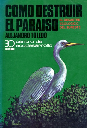
cover of "como destruir el paraiso"

It has long been recognized that environmental damage is particularly severe near the conglomeration of Pemex facilities in southern Veracruz near the mouth of the Coatzacoalcos River. The river suffers from chronic heavy petroleum pollution, receiving massive doses periodically when pipelines break. Possibly the only beneficial outcome of the decades of widespread damage caused by Pemex in its principal areas of operation in Veracruz, Tabasco and Campeche was that it prompted the publication in 1983 of Cómo destruir el paraíso (How to destroy Paradise), a book which gave an immense boost to Mexico’s then fledgling environmental movement.

Federal environmental agencies have had only limited success in forcing Pemex to take corrective actions. Pemex recognizes the problems and applies each year for more maintenance funds from the government. The government, however, sets a higher priority on funding exploration since Mexico’s oil reserves are running out. Pemex is fundamental to the Mexican economy but needs investment in maintenance and must become more accountable for its environmental impacts.

Mexico’s environmental issues are analyzed in many chapters of Geo-Mexico: the geography and dynamics of modern Mexico, including chapter 30. Explore the book using Amazon.com’s Look Inside feature and buy your copy today!

Jul 242011
 

This week’s “Sunday short” is about ziplines across the Guatemala-Mexico border, between El Carmen (Guatemala) and Talisman (Mexico). The story was reported by Mexico’s Televisa (a CNN affiliate). What might at first glance appear to be an enterprising form of adventure tourism is actually a means for undocumented migrants to enter Mexico on their way to the USA.

  • Migrants use zip line to cross Guatemala-Mexico border (includes video with commentary in English)

Apparently, there are several ziplines across the Suchiate River, which forms the border in this southeastern part of Mexico. The ziplines are not expensive, either. Whereas a similar ride might cost you US$60.00 in the USA or Canada, whizzing across the Suchiate River will cost you only 15 pesos or 10 quetzals (about $1.25).

Guatemalans normally require a visa to enter Mexico, but here, the local immigration authorities turn a blind eye, according to Rafael Romo, the Televisa correspondent. It is assumed that most of the Guatemalans crossing into Mexico are heading for the USA and the possibility of finding work there.

Too few discussions of the issues surrounding illegal migrants in North America recognize that Mexico faces its own problem of illegals— Central Americans desperate to cross the southern border with Guatemala, travel the length of Mexico and then cross into the USA.

If you find the zipline rates in the USA and Canada exorbitant, and want a less expensive adventure tourism experience, then head for the southern jungles of Mexico, but don’t forget to bring a Guatemalan visa with you if you plan to zipline across the Suchiate River!

Mexico has forty UNESCO-designated biosphere reserves

 Other  Comments Off on Mexico has forty UNESCO-designated biosphere reserves
Jul 232011
 

A surprising percentage of Mexico’s land area is protected in one form or another. A very large number of sites of archaeological or historical importance are managed by the National Institute of Anthropology and History, more commonly known by its acronym INAH. In theory, all buildings more than 100 years old have some degree of protection (under INAH), but in practice this protection is often ignored by developers with other ideas.

Sites considered significant for their natural beauty are protected in a variety of ways, ranging from nature sanctuaries of local importance to protected areas, national parks and internationally recognized biosphere reserves. In total, more than 11.5% of Mexico’s land area is now protected. This percentage has risen steadily for more than a century.

The designation of biosphere reserve can only be made by UNESCO (U.N. Educational, Scientific and Cultural Organization), in a manner somewhat similar to the designation that some major historical sites enjoy as World Heritage Sites. One of the benefits of attaining Biosphere Reserve status is that it allows access to more sources of funding for conservation programs.

Mexico currently has 40 biosphere reserves. Only the USA (48), the Russian Federation (41) and Spain (41) have more. Worldwide, there are now (July 2011) 580 biosphere reserves in 114 countries. The guiding principle of biosphere reserves is that the local populace is not displaced, but actively involved in all aspects of management, research and monitoring.

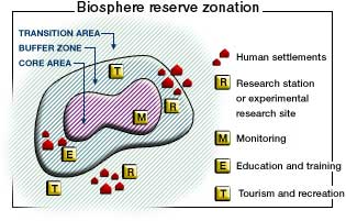
Biosphere Reserve Zonation

Biosphere reserves have a research-intensive core area or areas at their heart, surrounded by a buffer zone, where sustainable development is fostered, before gradually transitioning into the surrounding region. Many reserves have innovative systems of governance designed to ensure that the views of local people are fully respected. The idea of biosphere reserves was first proposed in 1968 at the UNESCO “Biosphere Conference”, the first international attempt to reconcile the need for conservation with the use of natural resources for development.

No system is perfect. The challenges for biosphere reserves include strengthening the worldwide network by establishing new reserves in areas where few currently exist, as well as helping meet the on-going funding needs for all the reserves. One of the most significant future threats to biosphere reserves is likely to be the habitat changes wrought by global warming.

One of the more startling surprises in the existing network of reserves is the almost total lack of protection afforded to such an amazing part of Mexico as the Copper Canyon region, with its indigenous Tarahumara people and world-class scenery. But perhaps one day this region, too, will become part of Mexico’s extensive system of protected areas.

Mexico’s Biosphere Reserves, as of July 2011:

Baja California Peninsula:

  • El Vizcaíno (Baja California Sur): desert, mountain and coastal/marine ecosystems, petroglyphs, wall paintings, birds and Grey whales.
  • Sierra La Laguna (Baja California Sur): contrasting ecosystems, woodlands and scrub, with high degree of endemism.
  • Alto Golfo de California (Baja California and Sonora): extraordinary geological formations with volcanic craters, dunes, oasis and beaches, and a diversity of plant associations.
  • Islas del Golfo de California (Baja California Sur and Sonora): series of over 240 islands with high number of endemic species; ornithological paradise.

Northern Mexico:

  • Mapimí (Durango, Chihuahua and Coahuila): fragile warm desert and semi-desert ecosystems.
  • La Michilía (Durango): mountainous area of pine-oak forest; habitat for the now rare black bear (Ursus americanus) and wolf (Canis lupus).
  • El Cielo (Tamaulipas): one of the most ecologically rich and diverse parts of Mexico; numerous endangered animal species; ecotourism area.
  • Laguna Madre and Río Bravo Delta (Tamaulipas): a migratory bird haven on coastal wetlands.
  • Cumbres de Monterrey (Nuevo León): the landmark mountains that ensure the water supply for the state capital.
  • Maderas del Carmen (Coahuila): encompassing parts of the Chihuahuan Desert in Coahuila state adjacent to the U.S. biosphere reserve of Big Bend National Park.
  • Cuatrociénegas (Coahuila): an oasis with 500 pools that preserve species found only in the Coahuila state part of the Chihuahua desert.
  • Sierra de Alamos–Rio Cuchujaqui (Sonora): endangered tropical deciduous forest.

Central and Western Mexico:

  • Sierra de Manantlán (Jalisco and Colima): transition of the Nearctic and Neotropical biological realms; cloud forest and wild perennial corn (Zea diploperennis).
  • Chamela-Cuixmala (Jalisco): a Pacific Coast dry tropical forest harboring iguanas and crocodiles in lagoons and marshes.
  • Islas Marietas (Nayarit): a biodiverse archipelago of islands with a rich mix of marine species, corals and landforms.
  • La Primavera (Jalisco): pine and oak forest in a caldera close to Guadalajara, Mexico’s second city.
  • Sierra Gorda (Querétaro): ecologically diverse area with 14 vegetation types, historic missions and Huastec Indians.
  • Monarch butterfly migration sites (Michoacán and State of México): unique annual migration links Mexico to Canada and the U.S.
  • Sierra de Huautla (Morelos): woods full of endemic species.
  • Barranca de Metztitlán (Hidalgo): home of Otomí Indians and large variety of wildlife.
  • Los Volcanes (State of México/Puebla) is the volcanic landscape of significant aesthetic and touristic value that surrounds the twin volcanoes of Popocatépetl and Ixtaccíhuatl.
  • Islas Marías (Nayarit), a group of four islands, perhaps best known for its federal penitentiary, with considerable diversity of ecosystems and many
    endemic species.

Eastern Mexico:

  • Los Tuxtlas (Veracruz): a beautiful jungle-covered volcanic region, with vestiges of pre-Hispanic archeology.
  • Sistema Arrecifal Veracruzano (Veracruz): an archipelago off the Caribbean coast.
  • Pantanos de Centla (Tabasco): villages in coastal wetlands.

Southern Mexico:

  • Montes Azules (Chiapas): Lacandon tropical rainforest; 500 species of trees; several indigenous groups (including Tzeltal, Chol and Lacandon Maya).
  • Volcán Tacana (Chiapas): fragile ecosystems in Chiapas, adjacent to Guatamala.
  • El Triunfo (Chiapas): diverse evergreen cloud forest in rugged mountain terrain; a primary Pleistocene refuge for numerous endemic plants and animals; large mobile population.
  • La Encrucijada (Chiapas): shrimping lagoons on the Pacific Coast.
  • La Sepultura (Chiapas): ancestral lands of the Olmec and other pre-Hispanic cultures.
  • Selva El Ocote (Chiapas): rain forests, caves and reserves of underground water.
  • Huatulco (Oaxaca): coastal reserve protecting endangered sea turtles, dolphins and purple snails.
  • Lagunas de Montebello (Chiapas) series of beautiful lakes close to the border with Guatemala, set in upland, wooded terrain, with varied flora and fauna including orchids, butterflies, fish, reptiles, mammals and birds.
  • Naha-Metzabok (Chiapas) northern section of the Lacandon tropical forest, home to several members of the cat family and an important part of the Mayan forest biological corridor

Yucatán Peninsula

  • Ría Celestún (Yucatán and Campeche): coastal region including important wetlands and drowned river valley (ría) with diverse fauna and flora, including flamingos.
  • Región de Calakmul (Yucatán): diverse tropical rainforests; the largest forest reserve in Mexico, with important Maya sites; ecotourism project.
  • Ría Lagartos (Yucatán): coastal estuary with diverse birdlife including more than 18000 pink flamingos as well as some 30,000 migratory birds.
  • Arrecife Alacranes (Yucatán): the largest coral reef in the Gulf of Mexico, and the only one in Yucatán state.
  • Sian Ka’an (Quintana Roo): coastal limestone plain, and extensive barrier reef system on Caribbean coast, with numerous archaeological sites; more than 4,000 plant species.
  • Banco Chinchorro (Quintana Roo): mosaic of open water, sea grass beds, mangroves, sandy beaches and coral reefs; more than 95 species of coral.

Main source: UNESCO: Directory of the World Network of Biosphere Reserves

Related posts:

Mexico D.F. administration offers amnesty to illegal water users

 Mexico's geography in the Press  Comments Off on Mexico D.F. administration offers amnesty to illegal water users
Jul 202011
 

According to a recent report in Ooska News (8 June 2011), Mexico City authorities have announced an amnesty for people who regularize illegal water connections. No fines will be levied, and they will be encouraged to pay only 600 dollars (a 50% discount) for registering connections and connecting to the waste water drainage network.

There are believed to be at least 250,000 illegal connections in Mexico D.F. Legislators hope that about half of these will take advantage of the amnesty program.

In the neighboring State of México, the National Association of Water and Sanitation (ANEAS) estimates that 60% of water connections in that area are also  illegal. ANEAS claims that 38% of all water in Mexico is lost through leaks in supply systems, including domestic connections, and a further 20% is lost because of illegal connections.

Related posts:

How will reduced out-migration impact Mexico’s total population?

 Updates to Geo-Mexico  Comments Off on How will reduced out-migration impact Mexico’s total population?
Jul 192011
 

As described in an earlier post –Is massive Mexican migration to the USA a thing of the past?– we examined a 6 July 2011 New York Times article which indicated that Mexican migration to the USA had slowed to barely a trickle. If this is correct, Mexico’s population will be considerably higher in future years. This post estimates what this impact will be.

In another post –Projecting Mexico’s population: when, if ever, will it stop growing? – we incorporated the results of Mexico’s 2010 census and 2008 migration estimates into the most recent official population projection available from the Mexican Government’s CONAPO (Spanish acronym for National Population Commission). This analysis indicated that Mexico’s population would peak at 140.5 million in 2043, rather than the 130.3 million indicated in the older CONAPO projection.

If net migration becomes zero in the future, as suggested in the New York Times article, Mexico’s population will peak at 149.3 million in 2051. If net migration in future years is between the 2008 estimate of 203,000/year and zero, say 100,000/year, then the Mexican population will peak at 144.9 million in 2049. Clearly, the variation in these projections of almost nine million (149.3 verses 140.5) is quite significant. Given these different projections, our current thinking is that Mexico’s population will probably peak at around 145 million about mid-century.

Though population projections based on birth and deaths rates tend to be fairly accurate, net migration projections are far more precarious. Actual net migration between the two countries will depend on a wide range of future socio-economic variables for both countries. The most obvious of these variables will be fertility rates, growth of the working age population, education opportunities, economic growth, trade regulations and trends, job availability, unemployment rates, and personal preferences of both workers and retired people. There undoubtedly will be surprises such as technology changes or climate change. Some of these may have very profound impacts on migration, and therefore on total population levels.

Migration between Mexico and the USA is the focus of chapters 26 and 27 of Geo-Mexico: the geography and dynamics of modern Mexico. Explore the book using Amazon.com’s Look Inside feature; buy your copy today!

Jul 182011
 

With so much media attention focused on drug violence in Mexico, many potential tourists and tour operators are canceling planned trips to Mexico. Are such decisions rational? The analysis below indicates that travel to Mexico is considerably safer than risking vehicle traffic in the USA.

The US State Department has issued numerous travel advisories concerning visits to Mexico. As we discussed in a previous post —Which parts of Mexico are currently subject to US travel advisories?— the advisories focus on specific areas of Mexico. Unfortunately, many potential tourists overlook the geographic specificity and get the impression that all parts of Mexico are dangerous. Previous posts clearly indicate that levels of drug war violence vary enormously from place to place in Mexico.

This post investigates the chances of being a fatal victim of drug violence in various places in Mexico and compares these with the chances of being a fatal victim of a traffic accident in the USA. The US Department of Commerce estimates that about 19 million US citizens visit Mexico each year. According to MSNBC, in 2010 at least 106 Americans were killed in Mexico as a result of drug violence. Dividing the 19 million visits by the 106 deaths suggests that the chance of a visitor being killed on a trip to Mexico in 2010 was about 1 in 179,000. These are good odds, much better than the annual chance of being killed in a US traffic accident which is about 9,000 to 1. In other words, the chances of dying in a US traffic accident are roughly 20 times greater than being killed as a consequence of drug violence while visiting  Mexico. (As an aside, the annual chances of being killed in a Mexican traffic accident are about 1 in 4,800.)

Chance of a visitor being killed in drug violence in MexicoRelative danger of death in a road accident in the USA
MEXICO (whole country)1 in 179,00020 times greater
Ciudad Juárez1 in 11,4001.3 times greater
State of Chihuahua1 in 18,5002.1 times greater
Culiacán1 in 25,0002.8 times greater
Mazatlán1 in 47,0005.2 times greater
Tijuana1 in 52,0005.7 times greater
Monterrey1 in 210,00023 times greater
Puerto Vallarta1 in 288,00032 times greater
Chapala1 in 299,00033 times greater
Cancún1 in 360,00040 times greater
State of Jalisco1 in 378,00042 times greater
Oaxaca City1 in 427,00048 times greater
Guadalajara1 in 569,00063 times greater
Mexico City1 in 750,00083 times greater
State of Yucatán1 in 4,151,000460 times greater
Puebla City1 in 6,572,000730 times greater

Some areas of Mexico experience much more drug violence than others. For example drug violence deaths in Ciudad Juárez are 16 times greater than the Mexico national average. Consequently, the chance of an American visitor getting killed in drug violence in Ciudad Juárez is about 11,400 to one, still safer than risking traffic in the USA. The table shows the risks for a range of Mexican locations and compares them to the risks of US traffic. In the city of Puebla the risk is one in 6.6 million compared to one in 750,000 for Mexico City, one in 570,000 for Guadalajara, one in 360,000 for Cancún, about one in 300,000 for Chapala and Puerto Vallarta, and about one in 50,000 for Tijuana and Mazatlán.

These results indicate that the chance of a visitor being killed by drug violence in Mexico is extremely unlikely, far less likely than the risk of being killed in a US traffic accident. For example, a visit to Chapala is 33 times safer than risking US traffic for a year, while Mexico City is 83 times safer. Though this analysis focuses on the travel of US tourists to Mexico, the results are equally relevant for visitors from other countries.

Jul 172011
 

Update: New Durango-Mazatlán highway officially open (Oct 2013)

Update: October 2012: Despite earlier claims that the Durango-Mazatlán highway would be completed before the end of this year, government officials have now confirmed that the highway will not be finished, and will not open, until sometime in 2013.

Original post:

In Durango recently, Dionisio Pérez Jácome, Mexico’s Communications and Transportation Secretary, stated that the new Durango-Mazatlán highway is “80% completed” and “on schedule to be opened in the second half of next year” (2012) (Milenio online, 15 July 2011)

The new highway, first proposed more than a decade ago, will have cost about 1.2 billion dollars to complete. The new highway has more than 60 tunnels and 115 bridges, including the amazing Baluarte Bicentennial Bridge which will be Latin America’s longest cable-stayed bridge when opened. Some sections of the new highway have had their first annual maintenance to repair potholes and ensure that the road surface is in perfect condition for next year’s formal inauguration.

The highway will speed up overland transport from the Pacific Ocean port of Mazatlán to the northern border towns of Reynosa and Matamoros, bringing numerous economic benefits to many parts of northern Mexico.


The spacing of central places in Mexico

 Excerpts from Geo-Mexico  Comments Off on The spacing of central places in Mexico
Jul 162011
 

Central place theory may work quite well in Mexico in terms of the relative numbers of settlements of different size, but the theory also suggests that those places on the same level of the urban hierarchy should form a distinctive spatial pattern and be roughly equidistant from one another. In essence, this means that each of these central places will be at the center of an approximately equally sized market area, or sphere of influence, well positioned to serve everyone who lives within its limits.

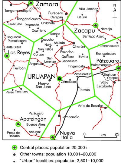
The application of central place theory to Uruapan, Michoacán

The application of central place theory to Uruapan, Michoacán. Credit: Tony Burton / Geo-Mexico; all rights reserved

The map shows the settlements in the western part of the state of Michoacán. The largest city by far is Uruapan (250,000 inhabitants in 2008). Around Uruapan are six fairly large neighboring towns or cities. Each of these settlements has its own corresponding market area. However, even though these six places are roughly equidistant from Uruapan, they turn out to be very different in size. For example, Zamora (240,000) has more than four times the population of Pátzcuaro (53,000). Zamora is bigger because in addition to providing services to a larger, more prosperous, surrounding market area, it also has some manufacturing and is on a railroad line and the original highway between Mexico City and Guadalajara.

In addition, there is no observable regularity in the pattern of settlements of the two smaller sizes—“other towns” and “urban localities”—shown on the map. This is clearly in contradiction to central place theory, but should not really be a surprise. The theory assumes, for the sake of simplicity, that large areas will not have any significant differences in relief or soil fertility and that transport costs will be directly proportional to distance. It also assumes that rural areas have equal population densities and that their residents have similar consumer tastes and purchasing power. In practice, these assumptions are not valid, and some of the anomalies in the pattern of settlements shown on the map can be easily explained. For instance, the areas immediately north of Apatzingán and east of Nueva Italia are very mountainous, far less favorable for farming and settlement than the area north of Uruapan.

The very idea that settlements will be equidistant from one another begs a very important question, pertinent to our earlier discussion of the categories of rural settlements. Should we measure distance only in a spatial sense, in kilometers, or might it be more worthwhile to consider it in terms of the time or monetary cost required to make a particular journey, taking into account the terrain and transportation network?

In summary, central place theory does a good job of explaining the number of central places at each level and the types of services they provide. At the same time, departures from the idealized shape and size of market areas predicted by the theory help to reveal the complexities of Mexico’s physical, human and socio-economic geography.

Related posts:

Exhibition of National Geographic images of Mexico at the Mexican Cultural Institute in Washington D.C.

 Other  Comments Off on Exhibition of National Geographic images of Mexico at the Mexican Cultural Institute in Washington D.C.
Jul 152011


If you’re visiting Washington D.C. this summer, don’t miss the exhibition entitled Mexico Through the Lens of National Geographic: celebrating a century of visual exploration, on at the Mexican Cultural Institute in Washington D.C. through October 22.

exhibition logoThe exhibition features more than 130 National Geographic images of Mexico taken from feature articles published in the magazine in the past 100 years. The images are arranged in seven groups: Explorers, The Maya, The 1916 and 1996 Special Issues on Mexico, Nature, The Border, People and The Photographic Eye.

Our attention was drawn to this exhibition by the always-interesting blog supporting National Geographic’s “My Wonderful World” Campaign. “My wonderful World” is an initiative to expand geographic learning in school, at home, and in communities—just the kind of initiative that we at Geo-Mexico.com wholeheartedly support.

Many people have great memories of particular National Geographic photos or articles that made an impact on their lives. In my case, by a happy coincidence, it is one of the images included in the “My Wonderful World” post about the exhibition: an image of Monarch butterflies that was included in the cover article of the August 1976 issue. This photo would change my life, though I didn’t know it at the time!

The Mexican Cultural Institute is located at 2829 16th Street, NW Washington DC 20009.  Gallery Hours are Monday–Friday from 10:00am to 6:00pm and Saturday from 12:00 – 4:00pm.  Enjoy!

Round-up of recent developments in Mexico’s Drug War

 Mexico's geography in the Press  Comments Off on Round-up of recent developments in Mexico’s Drug War
Jul 142011
 

Drugs smugglers are getting more and more creative in trying to circumvent drug trafficking and money laundering regulations either side of the Mexico-USA border. Flows of drugs northwards are counterbalanced by flows of cash southwards, since drug shipments have to be paid for somehow. What a shame that drug traffickers’ incredible ingenuity is not channeled into more legitimate and socially-responsible activities.

In March, one 33-year-old woman from Monterrey, Mexico, traveling back home from the USA, was apprehended aboard a trans-border bus with two teddy bears, each with their own pillow. How much cash can you stuff into two teddy bears? Well, if you add a couple of pillows into the mix, the answer is at least $277,556, since that is the total amount confiscated from Jeanette Barraza-Galindo. Her sentencing hearing is scheduled for September 8; she faces up to 5 years in prison and a $250,000 fine.

Just how can drug cartel leaders protect themselves and their assets, given the constant disputes between cartels and in-fighting within the cartels? Mexico’s luxury vehicle production has been doing suspiciously well for years; production of specialist armor-plated vehicles has been rising so rapidly that legitimate manufacturers are struggling to keep pace with demand. Drug capos consider armor-plated vehicles a necessity. So it perhaps not surprising that one cartel started its own production line. In June, the Mexican Army seized a factory in Camargo, Tamaulipas, that turned out armored vehicles for the Zetas, one of the most violent of Mexico’s drug gangs. In the process, it confiscated 28 vehicles, including four that were “ready to roll”, as well as numerous weapons.

What happens to the remains of drug lords killed in the war on drug cartels? Some of them end up occupying cemeteries that, for some future generation, will probably be viewed as macabre tourist attractions.

Perhaps the most extreme example is the Jardines de Humaya cemetery in Culiacán, Sinaloa, which has some of the most impressive funereal monuments in all of Mexico, up to and including mausoleums with stained glass, telephone lines and oriental rugs.

Where do all the guns come from? According to Jesús Enrique “El Mamito” Rejón, the answer is the USA. Rejón is a Zeta drugs gang boss, recently captured and interrogated by Mexican federal agents.

In the interview, Rejón says he deserted the Mexican Army in 1999 to join the Zetas. The Zetas have since become a multinational organization,purchasing drugs,  according to Rejón, through accountants who buy them from Guatemala and then transporting them across Mexico and into the USA. He says all the Zetas’ weapons have been purchased in the USA, and then smuggled into Mexico by a variety of routes, including walking across the international bridges connecting the two countries. Rejón claims that the Gulf Cartel gets its weapons more easily than the Zetas, suggesting that their leaders must have made a deal, perhaps with border officials. One of the many individuals apprehended at the border in recent months by police and customs agents was, US authorities allege, supplying an order from the Gulf Cartel which included 200 AK-47 assault rifles.

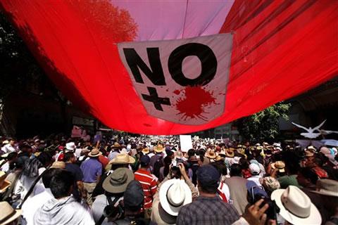
Protest march against drug violence (Mexico City, May 2011)

Protest march against drug violence (Mexico City, May 2011)

Finally, there is some good news. As has been reported elsewhere —Mexico winning cartel war—Mexico does appear to be making progress against the cartels. Numerous cartel leaders have been arrested or killed. This has led to renewed clashes between cartels as some seek to exploit perceived weaknesses in their rivals. Some splinter groups appear to be leaderless; their rank and file have lost their previous sources of income and so are now engaging in more localized acts of petty crime. Unfortunately, these are investigated by poorly equipped state or municipal police forces, rather than their much better-equipped federal counterparts.

As elections loom, there are renewed calls for an end to the violence, which has cost more than 35,000 lives since 2007. Protest marches have been held in many major cities, including one that generated a massive turn out in Mexico City in May (see photo).

Last month, a “caravan of peace” comprised of more than 14 buses and 30 cars began a journey which will take it through some of Mexico’s most troubled regions, including Ciudad Juárez.

Here’s hoping that things soon begin to improve and that we will not need to compile many more updates to Mexico’s war against the drug cartels.

Previous posts about the geography of drug trafficking and drug cartels in Mexico:

Geo-Mexico: the geography and dynamics of modern Mexico discusses drug trafficking, and efforts to control it, in several chapters. Buy your copy today to have a handy reference guide to all major aspects of Mexico’s geography!

Mexico’s GDP/person reaches all-time high

 Updates to Geo-Mexico  Comments Off on Mexico’s GDP/person reaches all-time high
Jul 132011
 

According to the National Statistics agency (INEGI), Mexico’s GDP/person broke all records in the first quarter of 2011 to reach 9,985 dollars/person, 15% higher than the equivalent period of 2010. The rise is due to continuing economic growth, coupled with the strength of the Mexican peso against the US dollar and other major currencies.

Mexico maintains its position as the world’s 11th largest economy. Mexico’s total GDP reached 13.588 trillion pesos (about 1.680 trillion dollars) in the past 12 months, 62.2% of which came from the tertiary (services) sector, 35.9% from manufacturing and 3.7% from primary activities.

The hierarchy of central places in Mexico

 Excerpts from Geo-Mexico  Comments Off on The hierarchy of central places in Mexico
Jul 132011
 

How well does central place theory fit the Mexican situation? In terms of the relative numbers of settlements of different size, it fits quite well. The theory suggests that there will be a regular (geometric) progression between the number of settlements of each successive size. The hierarchy of central places in Mexico is quite similar to that predicted by the theory (see table).

Population sizeNumber of localities or municipalities% of national population
< 2,500184,71423.5
2,500–9,9992,37910.6
10,000–49,99961512.1
50,000–499,99916225.6
500,000–999,9992313.9
1,000,000 +1114.3

At the lowest level in Mexico are a large number of very small centers providing a limited range of goods and services. At this level are small convenience stores (abarrotes or bodegas) selling basic Mexican household goods such as sugar, tortillas, bread, produce, snacks, basic canned goods, candy, eggs, beer, soft drinks, cigarettes, matches and basic toiletries.

Other small stores at this lowest level might sell such things as household cooking and lighting fuels (wood, gas, or kerosene), seed, animal feed, fertilizer and other basic farm inputs. Other services might include a place that buys agricultural production, auto and tire repair shops, and a bus pick-up point. Some of these small centers might also have tortillerías (shops making tortillas), a primary school and a pay phone.

At the next higher level there is enough demand to support everything at the lowest level plus simple bakeries, hardware stores, mini-super markets, electrician/plumbers, welding shops, simple clothiers or dressmakers, beauty salons, basic health care, simple pharmacies, a church, a secondary school, simple eateries, and repair of household electrical items (radios, blenders, TVs). There might be only half or a third as many settlements (places) at this level as at the lowest level.

Central places at this level might also have weekly or periodic markets. Such markets usually occur only one day a week because there is not sufficient threshold demand to support them on a daily basis.

The link is to a map showing the major weekly marketing cycles for the Oaxaca area in southern Mexico. With the exception of Oaxaca city (population 480,000) and Miahuatlán (33,000), all the other towns have populations between 13,000 and 20,000. The merchants at such markets generally carry their wares from village to village on the days of their respective markets. Some local farmers also sell their produce at such markets. These markets give villagers access to a much wider range of goods than might otherwise be possible. Simultaneously, traders maximize their opportunities to make a profit.

Depending on the rural population density and economic demand for particular goods and services in the geographic area, periodic or weekly markets may not exist at this level of the hierarchy in some regions and may only appear at higher levels.

A similar principle applies to a circus (figure 24.4 in Geo-Mexico), which needs access to an even larger threshold population than a weekly market. This is because each individual visitor will not be prepared to travel far to see the show and has little interest in seeing the same acts more than once. Even a very large city will only house enough people to fill the Big Top for a few weeks. The circus’s solution, in central place terms, is to access the combined populations of numerous towns or cities by moving from one to the next, on an annual or biannual itinerary.

As we move up the hierarchy in Mexico, there is enough demand to support everything at the lower levels as well as new services requiring higher levels of threshold demand. These might include doctors, dentists, carpenters, construction supplies, furniture and cabinet makers, bars, restaurants, a Pemex gas station, auto parts stores, and a variety of retail outlets selling such things as stationary and paper products, mobile phones, toys, flowers, plastic ware, and kitchen items. Centers at this level are larger and far fewer in number than the smaller centers at lower levels.

At the next higher level there are even fewer and even larger central places providing such services as appliance sales, jewelry stores, banks, opticians, lawyers, accountants, photographers, preparatory schools, hospitals, hotels, used car and pickup sales, a Coca-Cola bottler, funeral homes, a bus station, a Telmex office, TV and electronics sales, cyber cafes, clothing boutiques and shoe stores.

Further up Mexico’s hierarchy there is enough demand to support higher level services such as: new car and truck sales, TV and radio stations, movie theaters, giant supermarkets, printers, bookstores, dry cleaning, real estate offices and office supply stores. Centers at this level would be fewer in number and have larger geographic market areas.

At the top of the hierarchy are places like Mexico City and Guadalajara, where the demand is sufficient to support the highest level goods and services such as giant modern retail malls, international airlines, convention centers, international hotels, live theater, investment banking, TV studios, multimedia advertising agencies, major universities with medical schools, all types of specialized luxury products, and very specialized professional services such as heart and brain surgeons.

Related posts:


Is massive migration of Mexicans to the USA a thing of the past?

 Updates to Geo-Mexico  Comments Off on Is massive migration of Mexicans to the USA a thing of the past?
Jul 122011
 

Many people in the USA continue to blame undocumented Mexican immigrants for the country’s unemployment problems. These complainers do not seem to realize that the flow of undocumented Mexicans across the border has slowed to barely a tickle.

The total number of Mexican immigrants peaked at about 550,000 in 2006 [see chapter 26 of Geo-Mexico: the geography and dynamics of modern Mexico). That year over one million entered the USA and just under half a million returned to Mexico. With the economic recession and higher unemployment, the figure dropped to 203,000 by 2008. According Dr. Douglas S. Massey, co-director of the Mexican Migration Project at Princeton University, the flow of undocumented immigrants from Mexico may have stopped altogether. He states in a July 6, 2011 article in The New York Times by Damien Cave that, “For the first time in 60 years, the net traffic has gone to zero and is probably a little bit negative.”

While there are no hard data to back up Dr. Massey’s claim, the Pew Hispanic Center and most other experts think that net immigration of Mexicans, particularly undocumented migrants, to the USA has declined dramatically in recent years.

The New York Times article cited above suggests that the most important reasons for this observation are improved employment and educational opportunities in Mexico, rising border crimes, and reduced fertility levels in Mexico. It also mentions stricter US border enforcement, the greater danger and expense of illegal crossing, and tougher state immigration laws such as those in Arizona and Georgia.

The article also points out that the US Consulate in Mexico has changed its procedures, making it significantly easier for Mexicans to get temporary work visas (H-2A) as well as tourist visas. While this might reduce the number of undocumented immigrants, it undoubtedly has increased the number of both legal and total immigrants. Obviously some of those entering the USA with a temporary work or tourist visa might overstay their visa and become undocumented.

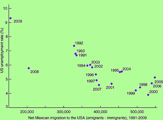
Scattergraph of US unemployment and net Mexican migration

Scattergraph of US unemployment and net Mexican migration Credit: Geo-Mexico; all rights reserved

It is interesting to us that The New York Times article says very little about the impact of very high US unemployment rates on the rate of immigration. Our analysis of data between 1990 and 2009 indicates that there is a strong negative correlation between the US unemployment rate and net Mexican immigration to the USA (see graph, r = -0.8, significant at the 95% level). While the reasons for reduced immigration cited in the article are all valid factors, it still remains to be seen if immigration will jump back up to about half a million a year when, and if, jobs in the USA become plentiful again and unemployment rates drop to the relatively low levels of 1998–2006.

Migration between Mexico and the USA is the focus of chapters 26 and 27 of Geo-Mexico: the geography and dynamics of modern Mexico. Explore the book using Amazon.com’s Look Inside feature; buy your copy today!

Jul 112011
 

Many Chicano activists refer to Mexicans as “La Raza”, literally “the race”. “Dia de la Raza” is celebrated on Columbus Day (October 12) as the day the Mexican indigenous population started their resistance against the European invasion.

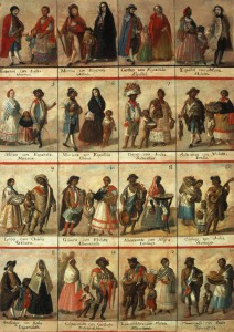
Racial classification in colonial times

Racial classification in colonial times (Click to enlarge)

The term “La Raza” derives from a 1948 book “La Raza Cósmica.” The author Jose Vasconcelos’ thesis is that Mexicans (who he defines as a combination of indigenous and European bloodlines) are a new superior race. In developing his thesis, Vasconcelos draws upon many concepts including Marxism; he felt Europeans were too materialistic and capitalistic. He suggested that Mexicans have evolved (à la Darwin) into a new race that would be a world leader in the years ahead. The Government of Mexico tacitly agreed with this approach which engendered national pride. It was also consistent with the government’s post Mexican Revolution view that all ethnic groups should be combined into a common Mexican national identity.

According to the 2010 census, about 15% consider themselves indigenous, though about 58% of these do not speak any indigenous language. Assuming the “white” and “other” categories are still about 10% and 2% respectively, this suggests that today about 73% are mestizos. Almost all people in Mexico refer to themselves simply as “Mexicans”, not as indigenous Mexicans or mestizos or whites.

Vasconcelos’ “Raza Cósmica” and most Mexicans overlook the historical fact that Mexicans have an important African heritage. Between 100,000 to 200,000 African slaves were brought into Mexico during the 16th through 18th centuries, nearly a quarter the number brought to the USA. In 1646 there were 35,000 African slaves in Mexico, more than 2.5 times the white population [see Blacks outnumbered Spaniards in Mexico until after 1810]. These slaves represented about 12% of the total population, roughly equal to the percentage of slaves in the USA before 1860.

Mexico’s second president, Vicente Guerrero, whose mother was partially Black, abolished slavery in 1829. Thousands of Blacks moved into Mexico from the USA before it abolished slavery in 1865. However, today there are very very few black faces in Mexico. One can spend weeks in Mexico’s major cities without seeing a Black Mexican. If one pays close attention, they can identify people of African heritage in a few selected communities in Veracruz and along the Costa Chica in Guerrero and Oaxaca [Bobby Vaughn’s homepage: Afro-Mexicans of Costa Chica ].

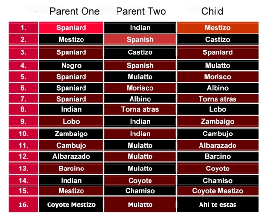
What happened to all the Blacks in Mexico?  [Blacks in Mexico] In a word they assimilated by having offspring with other racial groups. In colonial times, the Catholic Church went to great lengths to categorize intermixed races for marital and baptism purposes:

The terminology for racial mixes

Complex terminology for racial mixes

Before too long, nobody could keep all the combinations straight! Eventually, everyone of mixed race was considered a mestizo. The African portion was purposely or accidentally dropped.

Modern research, based on DNA, indicates that Mexican mestizos are genetically about one-eighth African [mtDNA Affinities of the Peoples of North-Central Mexico]. While Brazil is often identified as the world’s foremost melting pot, the evidence suggests that in Mexico the races have melted more than in any other country.

While there are very few black faces in Mexico, there is a great deal of African heritage represented in art, music, dance, food, and even in fishing and agricultural practices. Did you know that the popular Mexican song “La Bamba” recorded by Richie Valens, Los Lobos and others can be traced back to the Bamba district of Angola? As part of the 500th anniversary of Columbus’ famous voyage, the Government of Mexico finally acknowledged officially that Africa was Mexico’s “Third Root”.

Central place theory and rural access to central place services

 Excerpts from Geo-Mexico  Comments Off on Central place theory and rural access to central place services
Jul 092011
 

A previous post – The four basic types of rural locality in Mexico – indicates that access to sources of goods, services, markets and opportunities is very important to the economic and social well-being of rural and farm communities. Such sources are called central places and may be a village, a small town, a large town or a city.

Farms in rural areas may still grow some of their own food, but they are far less self-sufficient than they were a century or two ago. In Mexico, farm families are definitely part of the cash economy and buy more of their household needs than they produce on the farm. Items purchased from central places include such goods as sugar, clothing, hardware, farm tools, kitchen utensils, fertilizer, pesticides, hybrid seed, oil or kerosene for lamps, matches, paper products, as well as medicines, soft drinks, beer and cigarettes. Rural areas are also dependent on outside services provided by schools, buses, doctors, dentists, beauticians, mechanics and churches. To pay for these goods and services they are also dependent on markets where they can sell their farm products or their labor to obtain the cash they need to make necessary purchases.

Central place theory

Considerable academic attention has been focused on central places which provide goods and services to their market areas or hinterlands. Walter Christaller analyzed the German rural economy in the 1930s and developed central place theory. The theory provides an idealized description of how goods and services are supplied in rural areas throughout the world. Central place theory describes the spacing and hierarchy of central places by focusing on the threshold demand needed to support specific goods and services, the market areas of central places, and the distances rural people travel to obtain specific goods and services.

According to the theory, every rural region is served by a hierarchy of central places. At the bottom of the hierarchy there are a large number of very small places providing services with very low threshold demands. These very small centers serve the population in the center and a small surrounding rural area.

As one moves up the hierarchy, there are a fewer number of places, providing a wider range of goods and services, and serving a larger market area. This occurs because for a service to be provided efficiently there must be sufficient threshold demand in the center and its surrounding hinterland to support it. For this reason we do not find new car dealers, heart surgeons or ballet schools in every small village. These activities can only survive in large centers where there is sufficient demand.

Rural residents must travel varying distances to centers to obtain needed goods or services. The center may be small or may be large depending on the specific good or service that is needed. Rural residents might have to travel less than a few kilometers to a center at the bottom of the hierarchy to buy basic food stables or to attend primary school. They generally have to travel farther to a higher level center to get more specialized items such as clothing, health services, or secondary schooling. They generally have to travel considerably farther to buy a pickup truck, board an airplane or obtain the services of a heart specialist.

Related posts:


Severe hail storm hit central Mexico on 15 May 2011

 Mexico's geography in the Press  Comments Off on Severe hail storm hit central Mexico on 15 May 2011
Jul 072011
 

The severe hailstorm which struck parts of central Mexico on 15 May 2010 lasted up to 30 minutes in some places. It was a particularly intense storm, with golf ball-sized hailstones up to 5 cm in diameter.

The video below was uploaded to YouTube by . (The commentary is in Spanish).

The storm was caused by the southward movement of a strong cold front, which extended along the east coast of the USA and as far south as the Yucatán Peninsula. The cold front collided with hot air slowly circulating in an anticyclonic system that was stationary over central Mexico. The hot air was forced upwards, cooling to form heavy clouds, with moderate to heavy rainfall, and localized thunderstorms and hailstorms.

Despite the fact that Mexico’s National Meteorological Service had issued a weather forecast earlier that day correctly predicting the probability of severe hailstorms in much of central Mexico, damage from the hailstorms was considerable.

In the state of Puebla, 6,600 ha were affected, centered on the town of San Martín Texmelucan. This area included 500 ha of cornfields which were severely damaged. In addition, about 40,000 fruit trees—mainly apple and peach orchards—were badly hit; some of the 200 growers affected claimed that up to 70% of their trees had been damaged.

In Tlaxcala, more than 900 homes were damaged, as well as 1,500 vehicles and 400 ha of farmland. The worst-hit of the nine municipalities involved was Acuitlapilco, but costly damages were also reported from the municipalities of Totolac, Tlaxco, Panotla, Xaltocan, Hueyotlipan, Tecopilco, Atlangatepec and Muñoz de Domingo Arenas. Several emergency shelters were opened, though most of the people made homeless sought shelter with family or friends.

Climatic hazards, including hurricanes and hailstorms are analyzed in chapters 4 and 7 of Geo-Mexico: the geography and dynamics of modern Mexico. Buy your copy today, so you have a handy reference guide available whenever you need it.

The four basic types of rural locality in Mexico

 Excerpts from Geo-Mexico  Comments Off on The four basic types of rural locality in Mexico
Jul 062011
 

In a previous post, we looked at why Some rural areas are more rural than others.This post describes each of the four distinct categories of rural areas identified by Mexico’s National Population Council (CONAPO).

Rural localities near cities

This group is defined as localities within five kilometers (3 mi) of cities of at least 15,000 inhabitants. It accounts for 16% of Mexico’s rural population, about four million people. About half of the rural populations of Morelos and Tlaxcala fall into this group.

Some communities in this category are actually part of the suburbanization or urban sprawl process. People have ready access to many city services and opportunities. If they lack mechanical transportation, they can walk to the city in less than an hour.

What are the socioeconomic characteristics of these localities? The data needed to answer this question often are not readily available. Fortunately, CONAPO has classified rural localities in terms of their degree of marginalization, which provides insights into socioeconomic characteristics. Degree of marginalization is defined using indicators of adult educational attainment, housing quality, and income levels.

About 47% of rural, near city residents live in very marginalized localities.3 While this is much higher than it is in urban areas, it is significantly less than other rural areas. Rural areas near cities tend to be more similar to urban areas. By way of comparison, in Mexico as a whole about 19% of the population live in municipalities classified as very marginalized.

Representative characteristics of very marginalized communities include adult populations with illiteracy rates of about 25% and completion of primary school rates of only 56%. Roughly 27% of houses lack piped water, 27% lack indoor toilets, 46% have dirt floors and 64% are overcrowded. These housing indicators are closely correlated with significant health risks. About 15% of houses do not have electricity. Roughly 84% of economically active people make less than twice the minimum wage. Communities matching this description are very different from modern urban Mexico.

At the other end of the spectrum, only about 4% of near city residents live in non-marginalized localities, which we will call “modern”.5 For Mexico as a whole, 53% of the population live in modern municipalities. The figure is 100% for the 33 million people who live in Mexico’s nine urban areas of over one million inhabitants. Levels of marginalization will be discussed more fully in chapter 29.

Rural localities near towns

This category includes localities within three kilometers of towns with between 2,500 and 15,000 residents. About 2.4 million people, or 10% of the rural population, live in such communities. These localities account for about a quarter of the rural population of Morelos and the State of Mexico.

Communities in this category are more rural than communities near cities. They have easy access to goods and opportunities in towns, but lack ready access to a real urban area. About 66% of this group lives in very marginalized communities compared to 47% for the near cities group. Less than 1% of the near towns group live in modern communities.

Rural localities near roads

This large group includes localities within three kilometers (2 mi) of paved roads. Almost 13 million Mexicans, about 54% of the rural population, fall into this category. It accounts for almost 90% of the rural population in Quintana Roo and over 70% in Zacatecas, Yucatán, Campeche, San Luis Potosí, Nuevo León and Coahuila.

This is a relatively important category because almost 14% of Mexico’s total population lives in rural communities near roads. These localities account for 39% of the total population of Zacatecas, and about a third of the total for Hidalgo, Oaxaca and San Luis Potosí. The authors agree to differ as to the reasons for this. One of us believes that the location of paved roads is having an impact on rural settlement patterns. The other believes that rural settlement patterns are having an impact on the location of paved roads! Both viewpoints may be correct with their relative importance depending on the region in question.

While people living in these localities do not have walking access to a city or town, they can relatively easily get to a town or city by bus. Some 69% live in very marginalized communities, while less than 1% live in modern communities. In terms of marginalization, the near roads group is quite similar to the near towns group.

Isolated rural localities

This group includes rural localities that do not fit into any of the other three categories. They are the most rural in that they lack ready access to paved roads, towns or cities. These inaccessible areas are very rarely seen by outsiders. Most urban residents have limited understanding of life in these isolated areas. Communities in this group are among Mexico’s poorest. About 88% of the people in isolated rural localities live in communities classified as very marginalized; less than 1% live in modern communities.

Though data are not available, areas that are within 10 km of a city, town or paved road are likely to be less marginalized than those in more remote locations. Almost five million Mexicans, about 20% of the rural population, live in these communities. Over a million people in Chiapas and about half a million in Oaxaca and Puebla live in isolated localities. The figure for Chiapas represents 29% of the state’s total population. About 16% of the people in Nayarit and Oaxaca and 12% of those in Sinaloa and Guerrero live in isolated areas. Providing needed basic services to these rural Mexicans is a major challenge for these state governments as well as the federal government.

Related posts:

Less water available each year in Mexico as population increases

 Updates to Geo-Mexico  Comments Off on Less water available each year in Mexico as population increases
Jul 052011
 

Data from the National Statistics Institute (INEGI) show that Mexico’s available water has fallen to 4,263 cubic meters/person/year. Water availability depends on the amount of rainfall received each year and on total population. Mexico’s water availability has declined rapidly since 1950, when it was 18,053 cubic meters/person/year. Of 177 countries analyzed by the Food and Agriculture Organization (FAO), Mexico ranked 90th in terms of water availability.

According to INEGI, Mexico’s total current demand for water nationwide is 78.4 billion cubic meters/year, 11.5 billion more than natural replenishment rates. The drainage basins facing the most severe shortfalls are the Lerma basin in central Mexico, and the Río Grande in northern Mexico.

On the positive side, Mexico reached its UN Millennium Development Goal target for access to water 10 years early, by reducing the percentage of population without access to water in their homes from 25% in 1990 to less than 8% in 2010.

Mexico has also already met its target for improving access to wastewater drainage, where the proportion of the population lacking access to sewage systems has fallen from 37% in 1990 to 10% in 2010.

Mexico’s water resources and water-related issues are the subject of chapters 6 and 7 of Geo-Mexico: the geography and dynamics of modern Mexico. Ask your library to buy a copy of this handy reference guide to all aspects of Mexico’s geography today! Better yet, order your own copy…


The availability of water in Mexico

 Excerpts from Geo-Mexico  Comments Off on The availability of water in Mexico
Jul 042011
 

Though parts of northern Mexico are arid, the country as a whole receives an average of 760 mm of precipitation a year (slightly over 30 in). This is a considerable amount, more than that received by either Canada or the USA. However, 73% of Mexico’s rainfall either evaporates directly or or is lost from plants via evapotranspiration. About 25% runs off into rivers and lakes. Only roughly 2% seeps down to recharge subterranean aquifers.

Consumption of water, by sector

Consumption of water, by sector © Tony Burton / Geo-Mexico, 2010; all rights reserved

Availability of water per person is a function of population size and the total amount of water available. Though Mexico gets more rain than the USA or Canada, the availability of water per person in Mexico is only one-twelfth that of Canada and about half that of the USA because Mexico’s population density is far higher. In other words, though each square kilometer in Mexico receives more rain on average, that rain must be divided among more people. Of 177 countries analyzed by the FAO, Mexico ranked 90th in terms of water availability per person. However, if Mexico is divided into two zones, the south would rank 51st and the north would rank 131st.

Within Mexico, the Lerma Basin (between Mexico City and Guadalajara) has only about 1/3rd the national average for water availability, while the very heavily populated Valley of Mexico (containing the Mexico City Metropolitan Area) has only 1/30th the national average.

Mexico’s per person consumption of water is about half that of Canada but with proportionately more allocated to agriculture. Nationally, about 75% of water consumption is used in agriculture, while settlements and industry use about 17% and 8% respectively.

Mexico’s water resources and water-related issues are the subject of chapters 6 and 7 of Geo-Mexico: the geography and dynamics of modern Mexico. Ask your library to buy a copy of this handy reference guide to all aspects of Mexico’s geography today! Better yet, order your own copy…

Some rural areas are more rural then others

 Excerpts from Geo-Mexico, Teaching ideas  Comments Off on Some rural areas are more rural then others
Jul 022011
 

We all recognize that some cities are more urban than others. For example, Mexico City is considered more urban that a town of 20,000. By the same token, some rural communities are more “rural” than others. For example, a small settlement located near a city or along a main road would be considered less rural than an equally sized settlement in a more isolated area.

CONAPO's categories of rural area applied to eastern Michoacán

CONAPO's categories of rural area applied to eastern Michoacán. Credit: Tony Burton; all rights reserved.

The National Population Council (CONAPO) classifies rural localities into four groups based on accessibility to cities, towns and roads. The map shows how these four groups relate to a region in the eastern part of Michoacán state.

Suggested classroom exercise:

Appendix B of Geo-Mexico gives the percentages for each of these four rural groups in each state. What would be the best way to map the figures for the percentages of rural groups in each state?