| Geo-Mexico, the geography of Mexico

Aug 042023
 

How is this possible???? The 2023-2024 editions of Mexico’s free textbooks for school students are being roundly and rightly criticized on various fronts. Prepared and published by the Education Ministry (SEP), one of them includes this map:

v

Map in SEP textbook, 2023 edition

Time to play “Spot the Mistake.” Answer: Map has flipped the names of two states: Guanajuato and Querétaro. Astonishing! How is this possible?

Dear SEP: For future reference, Geo-Mexico is always happy to be contracted to provide proof reading and geography fact-checking…

And, if you thought the map was bad . . . at least it is almost correct, which is more than can be said for this graphic of the Solar System, taken from another 2023-2024 free SEP textbook:

We’re not going to insult the intelligence of our readers by pointing out why this is totally misleading!

To students and teachers everywhere: Have a happy and successful 2023-2024 Academic Year.

Mar 152023
 

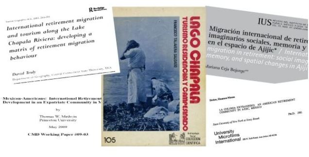
Numerous academic studies have looked at different aspects of the long-established Ajijic retirement community at Lake Chapala. The earliest studies, in the 1970s, looked almost exclusively at the characteristics of the incoming migrants.

Mexican sociologist Francisco Talavera Salgado in Lago Chapala, turismo residencial y campesinado, focused exclusively on the varied impacts of foreign residents on the local Ajijic community.

academic-coversAnthropologist Eleanore Moran Stokes homed in on Ajijic and suggested that the evolution of the village after ‘Discovery’ could be divided into three distinct phases: Founder (1940s to mid 1950s), Expansionary (mid 1950s to mid 1970s) and Established Colony (mid 1970s through the 1980s). During the Founder phase, Ajijic served, in her view, largely as an artists’ colony, whereas later (Expansionary phase) arrivals tended to be members of the affluent and retired middle class; these newer arrivals began to materially change the village by infusing cash into the local economy and starting businesses. They upgraded village homes and created “a new wage labor class in the village.”

In the Established Colony phase vacant houses became increasingly scarce, agricultural land was parceled for vacation and retirement homes, and philanthropic activities became important. Stokes estimated that, by 1979, foreigners occupied about 300 of the 950 houses in the village, but comprised less than 8% of the population.

Geographer David Truly built on Stokes’ framework to develop a matrix of retirement migration behavior. Like Stokes, Truly concluded in 2002 that newer visitors (including retirees), and unlike earlier migrants, had less desire to adapt to the local culture and were more keen on ‘importing a lifestyle’ to the area.

Sociologist Stephen Banks, studied the identity narratives of retirees while he was living in Ajijic in 2002-2003. He concluded that the responses he received during dozens of in-depth interviews revealed:

a struggle to conserve cultural identities in the face of a resistant host culture that has been colonized…. The Lakeside economy is dominated by expatriate consumer demand; indigenous commerce in fishing has disappeared as new employment opportunities opened up in the services sector; local prices for real estate (routinely listed in US dollars), restaurant dining, hotel lodging and most consumer goods are higher than in comparable non-retirement areas; traditional Mexican community life centered around the family has been supplemented, and in some cases supplanted, by expatriate community life centered around public assistance and volunteer programs… and the uniform use of Spanish in public life is displaced by the use of English.”

Some more recent work has focused on the changes in the host community. For example, Marisa Raditsch investigated the impacts of international migrants “based on the perceptions of Mexican people in the receiving context.” Her 2015 study found that these perceptions tended “to be favorable in terms of generating employment and contributing to the community; and unfavorable in terms of rising costs of living and some changes in local culture.”

Even more recently, Mexican researcher Mariana Ceja Bojorge focused squarely on the relationships and interactions between local Ajijitecos and foreigners. She concluded in 2021 that the shift “endangers the acceptance of the presence of the other” and that “Although the presence of foreigners has generated economic well-being in the area, it has also been responsible for the reconfiguration of space, where locals have been forced to leave their territory.”

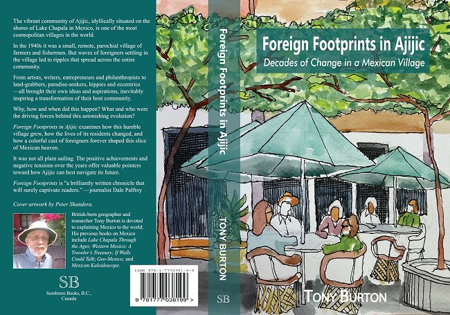
The details of the extraordinary changes that have taken place in Ajijic since the 1930s are the subject of my 2022 book, Foreign Footprints in Ajijic: Decades of Change in a Mexican Village.

This cover of the book shows a popular restaurant on Ajijic plaza, a perfect example of these changes or reconfiguration of space. The plaza was originally a Mexican space, where locals filled water containers, met friends, gossiped, socialized and bargained at the weekly market. The chapel and all the stores around the plaza were exclusively run by village residents to meet local needs. In those years, if there was a center for foreigners it was the Posada Ajijic bar, restaurant and gardens.

The use of the plaza has changed. After Cine Ajijic opened on the north side of the plaza in 1969, its weekly English-language films actively encouraged foreigners (en masse) to share the same social space as the local community. The supermarket on the south side of the plaza also became a shared space for locals and foreigners, a dual role which continued after the premises became a bank. Stores and restaurants either owned by, or designed to serve, foreigners were established around the plaza. An even stronger foreign focus is evident in the plaza coffee shops which spill over onto what was formerly public space. This has inevitably resulted in a debate about the appropriateness of a private enterprise occupying public space, and whether even paid use, via concessions, is an acceptable tradeoff for the loss of such space. Compromise is needed by all; there will never be any one-size-fits-all solution to any of the issues arising from migration and cultural change.

Full bibliographic details of all the studies mentioned above are included in the bibliography of Foreign Footprints in Ajijic: Decades of Change in a Mexican Village

Geo-Mexico is reader-supported. Purchases made via links on our site may, at no cost to you, earn us an affiliate commission. Learn more.

Is the south shore of Lake Chapala in Jalisco or in Michoacán?

 Maps, Mexico's geography in the Press  Comments Off on Is the south shore of Lake Chapala in Jalisco or in Michoacán?
Aug 242022
 

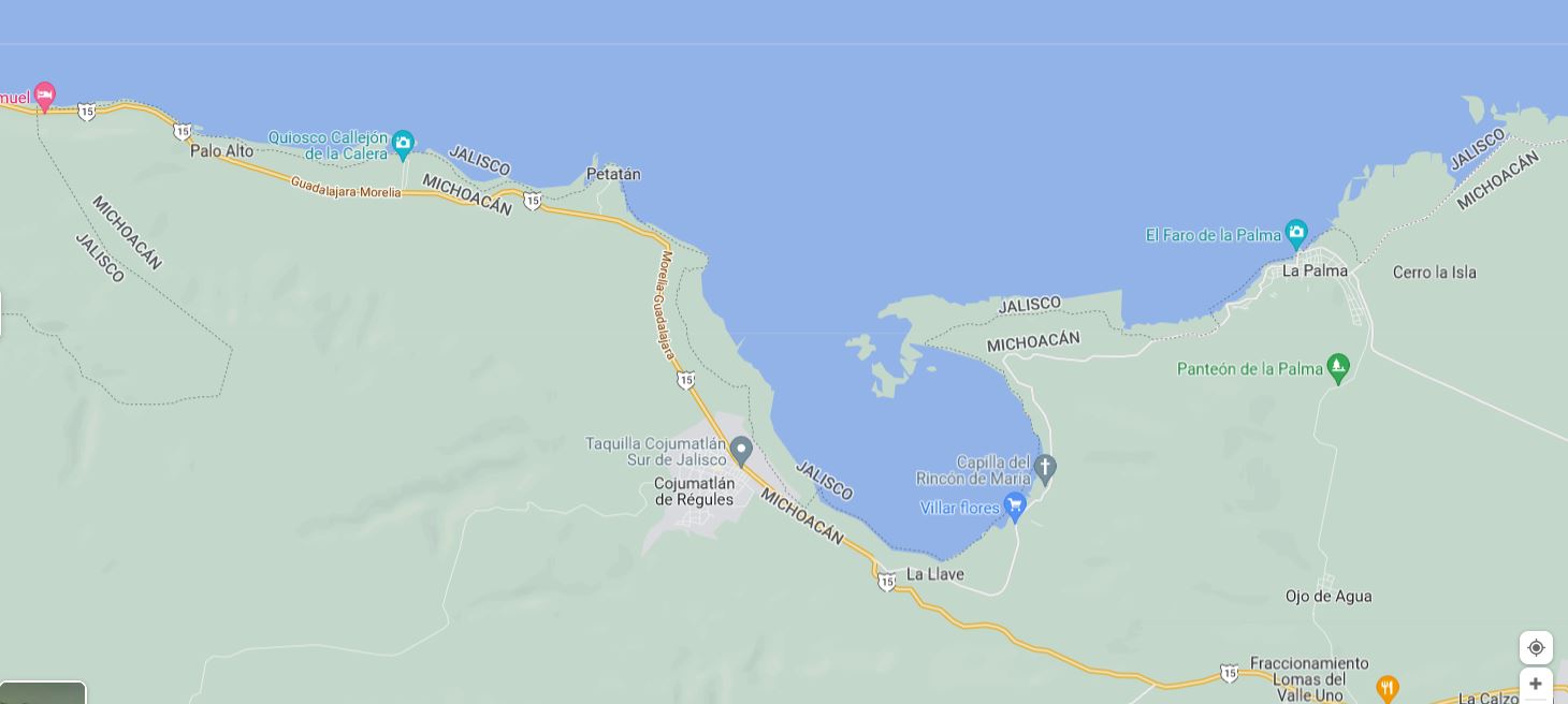
According to Google Maps, the entire southern shore of Lake Chapala belongs to Jalisco, not Michoacán . . .
– Según Google, toda la orilla sur del lago Chapala pertenece a Jalisco, no a Michoacán . . .

The south shore of Lake Chapala according to Google Maps (2022)

Google might want to alert Mexico’s mapping and statistics agency, INEGI, to that ‘fact.’

Google knows best? Not always!!

Copyright


Copyright

To the fullest extent permitted or available under applicable law, Geo-Mexico, Sombrero Books and the Officers thereof, hereby assert and claim, and the User hereby recognizes and acknowledges, copyright protection for Sombrero Books, and any part thereof, including without limitation the form, format, mode or method of compilation, design, layout, configuration, presentation or expression thereof and any information or data included therein.

Derechos Reservados.

Copyright 2008-2022 Sombrero Books. Todos los derechos reservados. All rights reserved.

Can I use the materials from Geo-Mexico?

Many people ask us if they can reproduce articles from Geo-Mexico. The answer depends.

What follows are the guidelines to follow:

  • No materials may be used where revenue or benefit is received from the reproduction of the materials.
  • No materials may be used without receiving permission from the individual authors and from Sombrero Books.
  • Where an article states that it has been reproduced or mirrored “with the permission of”, the originating source must be contacted for permission to use.
  • Where materials are reproduced, they must clearly state:
    “As presented at Geo-Mexico — https://www.geo-mexico.com”

Geography 13


Welcome to your How well do you know Mexico? QUIZ 1

1. 
Which of the following is the largest state (in area) in Mexico?

2. 
What was Mexico's total population in 2020, according to the 2020 Census?

3. 
On average, how many people live in a household in Mexico?

4. 
Which of the following is the odd one out, and why?

5. 
Which of the five states shown on the map is Guerrero?

6. 
The waterfall once known as the "Niagara of Mexico" is close to which of these cities?

7. 
In which year was Mexico City hit by a magnitude 8.1 earthquake?

8. 
What is the name of the main indigenous group living in Mexico's Copper Canyon region?

9. 
At current rates of extraction, how long will Mexico's 3P (proven, probable, possible) reserves of crude oil last?

10. 
When did construction begin of Cancún, the major tourist resort in Quintana Roo?

Mar 152022
 

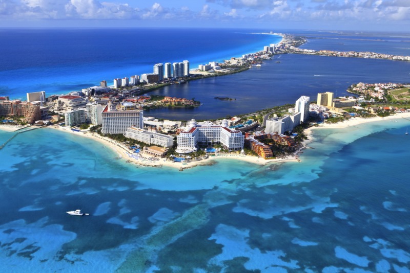
The answer appears to be a resounding “No!” This article in the Guardian explains why:

And what’s true for Cancún is likely to be true for almost all the beaches in Quintana Roo along Mexico’s Caribbean coast.

Cancún by Arthur Gonoretzky (Flickr)

Cancún by Arthur Gonoretzky (Flickr)

Related posts:

Dec 172021
 

Christmas festivities in Mexico are not just a one-day wonder but extend over several weeks, and are already well underway!

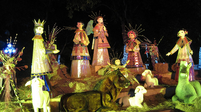
Nativity scenes such as this one are popular with all ages:

Modern Mexican Nacimiento. Photo: Ariaski (Flickr);

Modern Mexican Nacimiento. Photo: Ariaski (Flickr); creative commons license

Unlike in many other countries, the custom of gift-giving at this time of year was not tied to Christmas Day but to Three Kings Day (6 January), a custom that has changed rapidly with rampant advertising and commercialization of the holiday season:

Still looking for a Mexican-themed Christmas gift? Try any of these books (Kindle or soft cover) by Geo-Mexico co-author Tony Burton, available on all Amazon sites – Books on Mexico; this romance-adventure novel by Jan Dunlap, set in 1970s’ Mexico – Dilemma; or this beautifully-written memoir of a childhood in Mexico (Mexico City and Lake Chapala) – According to Soledad – by Katie Goodridge Ingram. For an inspiring and heart-warming non-fiction work, try Gwen Burton’s  New Worlds for the Deaf, which recounts the history of a pioneering school for the deaf in Jocotepec, Jalisco.

Mexico has had numerous unusual public Christmas trees in recent years, including:

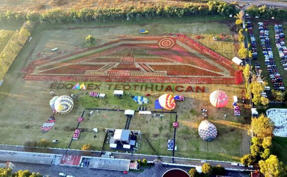
Mexico is the original home of the poinsettia, the decorative plant of choice for interior decorators during the festive season. This year, a massive (Guinness award-winning) floral carpet of poinsettias covering 17,805 square meters – mainly of white and red varieties – was arranged at the pyramids of Teotihuacan, just outside Mexico City:

Credit: Mexico Daily News / EdomexTurismo

Mexico also gave the world the turkey, corn and pumpkin pie:

Curiously, the idea of having a Christmas Tree at Christmas time in Mexico seems to be a relatively recent custom, an example of a “cultural invasion”:

The custom of having a family or community Christmas Tree has led to an ever-growing demand for Christmas trees, many of which are now grown and harvested in Mexico:

Christmas trees are not complete without Christmas ornaments and Mexican handicraft artisans have been cashing in on the demand for decades, especially in such creative states as Michoacán:

Some parts of Mexico work on Christmas most of the year! For example, the manufacturing of beautiful handmade Christmas tree decorations is the main industry today in the former gold and silver mining town of Tlalpujahua in the state of Michoacán. The production of Christmas ornaments in Tlapujahua has a great series of photos by Arturo Toraya of Notimex, showing some of the steps involved.

ornaments-2

As the accompanying text explains, “Making baubles for Christmas trees is the main source of jobs in the town, which is now one of the top five producers in the world. Due to their quality, 90 percent of the total production is exported to the U.S. and Canada. There are 200 family workshops in the town with seven-hour shifts, and each worker can make up to 550 baubles per day. Each workshop decorates about 500 per day. Red, blue, green and yellow are the top selling colors in Mexico, while black, brown and grey are more popular in the U.S.”

The village of Tzintzuntzan, on the shores of Lake Pátzcuaro, also in Michoacán, is another settlement where Christmas seems to be a year-round source of inspiration. The village handicraft market is a cornucopia of straw work in every conceivable color, design and size, which make ideal Christmas decorations or gifts.

Craft market in Tzintzuntzan, Michoacan

Craft market in Tzintzuntzan, Michoacan

Happy Christmas from Geo-Mexico! – ¡Feliz Navidad!

The impacts of the US border wall with Mexico

 Books and resources, Teaching ideas  Comments Off on The impacts of the US border wall with Mexico
Jan 162021
 
Judy King cover

This Guardian article – ‘My neighbourhood is being destroyed to pacify his supporters’: the race to complete Trump’s wall – highlights the problems created (not solved) by US efforts to build a wall along its southern border.

Geo-Mexico is reader-supported. Purchases made via links on our site may, at no cost to you, earn us an affiliate commission. Learn more.

Judy King coverFor what it’s worth, here is my own take on the wall, written a few years ago as a short chapter for Judy King’s book, Echoes from the Wall: Real Stories of Mexican Migrants (Mexico Insights, 2019). The majority of King’s book is based on her one-on-one interviews with a varied and fascinating selection of Mexican migrants who at one time or another lived and/or worked in the US. King’s personal, in-depth approach was time consuming but was amply rewarded and she acquired some extraordinary individual accounts. The book also includes short “backgrounders” on the history of Mexican-US migration and the practicalities involved.

My chapter focused on the geography related to the wall building.

The Border Story: the effects of a barrier wall (written in 2018)

The U.S.-Mexico border is unique in terms of its geography. It is the longest land border in the world between a developed economy and an emerging economy. The continental U.S.-Mexico border (excluding offshore limits) is about 1990 miles (3200 km) long. At roughly the mid-point, the cities of El Paso and Ciudad Juárez face each other across the boundary line. East of these cities, the border follows the course of the Río Grande (Río Bravo as it is known to Mexicans) to the Gulf of Mexico; west of these cities, it crosses the Sonoran desert to reach the Pacific Ocean between San Diego and Tijuana.
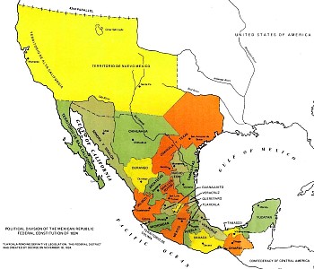
Map of Mexico, 1824

Map of Mexico, 1824

This boundary was established in the middle of the 19th century. After the Mexican‑American War (1846‑1848) the 1848 Treaty of Guadalupe Hidalgo ceded over half of Mexico’s territory to the USA. A few years later, under the 1853 Gadsden Purchase (Treaty of La Mesilla), northern portions of Sonora and Chihuahua were also transferred to the USA. This more or less established the current border between the two countries.

Minor disputes have occurred since due to the constantly migrating meanders of the Río Grande/Bravo. Flooding during the early 1860s moved the river channel south, shifting an area of about 2.6 square kilometers (1 square mile) from Ciudad Juárez in Mexico to El Paso in the U.S. Both countries claimed the area, giving rise to the El Chamizal dispute. This dispute went to international arbitration in 1911 and was only finally resolved in 1963 with the ratification of the Chamizal Treaty by President John F. Kennedy and his Mexican counterpart, Adolfo López Mateos.

A permanent memorial to Chamizal was established in El Paso in 1966 to commemorate the two nations’ laudable international cooperation, diplomacy and respect for cultural values in arriving at a mutually acceptable resolution to the conflict. A later dispute about changes in river meanders – the Ojinaga Cut – was amicably resolved in 1970.

There are about fifty places where people can legally cross the U.S.-Mexico States border but only one where the cities on either side of the border have the same name: Nogales. Historically, straddling the international border was not a drawback to residents of the “Two Nogales” (Ambos Nogales).
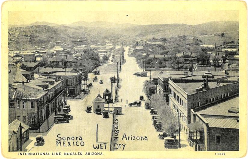
Postcard of Ambos Nogales, ca 1915

Postcard of Ambos Nogales, ca 1915

A century ago, one street in Nogales – International Avenue – actually ran east‑west along the border, with one side of the street in the U.S. and the other in Mexico. Even before a boundary fence was erected down the middle, residents were apparently still required to cross at one of two entry points: either the Morley Avenue crossing or the Grand Avenue crossing. The 60-foot-wide avenue had been created in 1897 after all buildings close to the border were razed to the ground as a way of limiting customs fraud. A permanent border fence was built in 1918 following the Battle of Ambos Nogales (La batalla del 27 de agosto).

During the prohibition years (1919-34) in the U.S., Mexican cities close to the border benefited from an influx of free-spending visitors. These years were boom times for the bars, casinos, brothels and race tracks of cities such as Ciudad Juárez and Tijuana. These cities also did well during World War II, when many of the large number of U.S. military personnel stationed near the border were able to circumvent wartime rationing at home by hopping south.

Beginning in the mid-1990s, physical barriers (fences, walls) were erected along some sections of the border to try and stem the flow of migrants from Mexico. Other sectors are closely monitored via electronic sensors, drones, cameras and mobile and satellite surveillance systems. In total, about 30% of the border already has some form of barrier, physical or virtual.

Existing barriers have already made life very difficult in many places. For example, it used to be a ten minute walk for residents of Ejido Jacume in Baja California to cross the border into Jacumba Hot Springs, California, to go to school, work, shop or attend the health clinic. With the barrier, it is now a two hour drive via Tecate.

Most of the physical barriers already built are along the western half of the border (where California, Arizona and New Mexico meet Baja California, Sonora and Chihuahua), They aim to prevent undocumented crossings into the major cities, especially San Diego and El Paso. They have forced would-be migrants to take on crossing the border somewhere in the largely unpopulated Sonoran Desert west of Nogales. The arduousness of this trip has cost the lives of many, many migrants, with the number of deaths of border-crossers since 2004, in this section alone, averaging more than 200 a year.

One of the many ironies associated with demands to build more and higher barriers between the two countries, given their extremely close social and economic ties, is that there is a simultaneous demand (in other quarters) to ease the movement of people and goods across the border in order to boost tourism and facilitate trade. For instance, in December 2015, a 120-million-dollar pedestrian bridge, known as The Cross Border Xpress (CBX), opened to allow passengers living in California to walk across the border into Tijuana International Airport. This helped ease border congestion at the existing land crossings into Tijuana.

Similarly, U.S. and Mexican border officials have piloted joint customs inspection procedures to cut border-crossing times for freight by up to 80%. Trade between the two countries is worth 1.4 billion dollars a day. The first tests of the new joint system were at Laredo international airport in Texas (for vehicle, electronic and aerospace components being flown to eight cities in Mexico), the Mesa de Otay in Baja California (for Mexican farm products entering the U.S.) and San Jerónimo in Chihuahua (for computers and other electronic exports from Mexico). The project has been warmly welcomed by business representatives on both sides of the border.

Finding the right location to build any barrier/wall may prove harder than many would anticipate. While most existing sections of barriers along the western half of the border are located very close to the true boundary line, this is not possible east of El Paso where the boundary runs (theoretically) down the deepest channel of the Río Grande/Río Bravo. Here, a wall or barrier along the boundary is impracticable.

Several protected National Wildlife Refuge (NWR) areas sit on or astride the boundary. They include the Lower Rio Grande Valley NWR and the Santa Ana NWR in Texas, the the Tijuana Slough NWR in California, and the Cabeza Prieta NWR in Arizona (the 3rd largest national wildlife refuge in the lower 48 states) which is contiguous to the UNESCO-designated World Heritage site of El Pinacate y Gran Desierto de Altar Biosphere Reserve in Sonora. In west Texas, Big Bend National Park extends to the border where it meets the Cañon de Santa Elena National Park in Chihuahua.

Ecologists have grave concerns about animal migration corridors and the future of numerous trans-border species. Up to now, only rudimentary and superficial Environmental Stewardship Plans (ESPs) have been prepared for the border areas where barriers have been constructed. These ESPs almost invariably claim that any adverse impacts on plant and animal populations will be only short-term, even in the absence of any scientific studies assessing existing populations.

Barriers such as walls prevent some species from crossing the border and can separate existing cross-border populations into two distinct groups, reducing their viability and increasing the risks of in-breeding, reducing their resilience to changes in climate or food sources. One major study identified 93 currently endangered species likely to be affected by a wall, including jaguars, ocelots, Mexican gray wolves and Quino checkerspot butterflies. Black bears in Texas that currently migrate across the border annually will have their natural territory sliced in half, as will the pronghorn antelope herds further west. Several species, including the jaguar, arroyo toad, the cactus ferruginous pygmy owl (which flies close to the ground) and Peninsular bighorn sheep, have critical habitats either side of the border.

People, too, have cross-border territories. Spare a thought for Native American groups such as the Tohono O’odham people whose ancestral lands now lie on either side of the Arizona-Sonora border. Their divided territory originated in 1853 with the Gadsden Purchase. Most of the estimated 25,000 Tohono O’odham alive today reside in Arizona but about 1500 live in northern Sonora. For decades, the two groups of Tohono O’odham, never granted dual citizenship, kept in regular contact for work, religious ceremonies and festivals, crossing the border as needed without any problem. Stricter border controls have made this impossible today.

Repeated efforts to solve the “one people‑two country” problem by granting U.S. citizenship to all registered members of the Tohono O’odham, regardless of their residence, have so far not succeeded. Ironically, because of its relatively remote location, the Tohono O’odham Nation has often been called upon to provide emergency assistance to undocumented workers (and drug traffickers) attempting to cross the border who have underestimated the severe challenges of crossing this section of the harsh Sonora desert.

Land ownership along any wall-building line is another issue. Building it on federal land is relatively easy, especially if the U.S. administration continues to utilize mechanisms that ignore, or they claim trump, dozens of existing environmental and cultural laws. Costs and protests rise where the planned barrier is located on privately-owned land.

Some sections of barrier have already been built in the wrong place. In 2008, for instance, one Native American human rights delegation reported that the official International Boundary obelisks marking the Arizona/Sonora boundary had been moved about 20 meters south during barrier construction, a clear violation of international law. Costs escalate still further whenever the barrier needs to be relocated.

The effective implementation of many cross-border agreements will be adversely affected by a barrier. For instance, the U.S. Forest Service and Mexico’s National Forestry Commission have a co-operation agreement, the Bi‑national Convention on Forest Fires, for dealing with cross-border wildfires on the Arizona/Sonora border. It aims to increase public safety on both sides of the border, reduce habitat loss, and facilitate the fighting of wildfires. It allows for a united bi‑national command to be established and for firefighting brigades, together with supporting vehicles and aircraft, to cross the border by up to 16 km (10 miles) in either direction in order to battle ongoing wildfires, provided advance notice is given. With a wall, this is clearly impossible.

Quite apart from the cost implications and the potential adverse impacts for people, communities, trade and fauna in the border regions, building a wall is not the answer. Animals may not have a viable choice after a wall is built but if people still want to cross, and can’t do so by land, they will surely turn to the air, the oceans, or (as has already happened repeatedly with smugglers in both directions) underground tunnels.

In fact, despite fear-mongering news reports in the U.S. press, the flow of migrants over the past decade has actually reversed: the number of people now crossing the border from the U.S. to live in Mexico is higher than the number of Mexicans moving north. While some of the migrants moving south are Mexicans returning home, others are estadoudienses preferring to retire, live or work in Mexico.

Judy King’s Echoes from the Wall: Real Stories of Mexican Migrants (Mexico Insights, 2019) is available worldwide via Amazon. The case studies of individual migrants are excellent starting-points for geography classes about international migration in high schools and colleges.
Nov 262020
 

We have frequently published international comparisons showing how Mexico fares in comparison with other Latin American countries and major world economies for a wide variety of indicators.

Reliable comparisons for comparing countries on their Covid-19 response have been hard to come by, but here is a link to one compiled by Bloomberg News:

As the article concludes, Mexico’s response to Covid-19 does not bode well for future economic progress. Nor does it bode well for reducing economic and social disparities within Mexico.

Stay safe!

Many of the key ingredients of American Thanksgiving come from Mexico!

 Other  Comments Off on Many of the key ingredients of American Thanksgiving come from Mexico!
Nov 242020
 

Happy Thanksgiving to all our American readers!

Try the following links to learn more about Mexico’s contributions to Thanksgiving. For starters, what about the idea that Thanksgiving originated in Mexico, not in the USA!

thanksgiving-cartoon

That idea may be slightly controversial, but most celebrations of Thanksgiving certainly have some close ties to Mexico since they are likely to include one or more of the following ingredients:

These items, and many other food items that originate in Mexico, have come to play an important role, not only for American Thanksgiving celebrations, but also for many of the world’s finest cuisines.

¡Buen provecho! ~ Happy Thanksgiving!

Looking for a fun way to learn more about Mexican history and culture?

Tony Burton’s book, Mexican Kaleidoscope: myths, mysteries and mystique explores some of the reasons why Mexico is such an extraordinarily diverse and interesting nation. The book’s 30 short chapters range from the mysteries of Mexican food, Aztec farming and Mayan pyramids to mythical cities, aerial warfare, art, music, local sayings and the true origins of Mexico’s national symbols.  – “a suitable gift for the novice flying to Mexico for vacation, while at the same time a cherished companion for the expat already comfortably at home there.” – Dr Michael Hogan, Author of Abraham Lincoln and Mexico.

The transformation of Chapala from fishing village to international tourist destination

 Other  Comments Off on The transformation of Chapala from fishing village to international tourist destination
Sep 032020
 

The town of Chapala, on the shores of Lake Chapala—Mexico’s largest natural lake—played an important role in the history of tourism in North America and has become one of the world’s premier retirement destinations. Yet, the details of how and why this transformation occurred have never been adequately reconstructed… until now!

Geo-Mexico is reader-supported. Purchases made via links on our site may, at no cost to you, earn us an affiliate commission. Learn more.

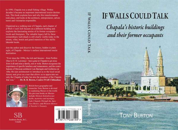
My latest book If Walls Could Talk: Chapala’s historic buildings and their former occupants, reveals the results of more than two decades of research. The book explores the history of the town’s formative years and shares the remarkable and revealing stories of its many historic buildings and their former residents.

The front cover shows the waterfront of Chapala at the start of the twentieth century. On the right is the parish church of San Francisco, which dates back to the sixteenth century and features in D. H. Lawrence‘s novel The Plumed Serpent, set at the lake. (The house Lawrence rented in 1923 is now a boutique bed and breakfast.) The turreted tower on the left is part of the Villa Ana Victoria which was built by the Collignon family of Guadalajara in the 1890s, right at the start of the village’s explosive growth.

The illustration is a photograph by American photographer Winfield Scott that was colorized and published in about 1905 by Jakob Granat, a postcard publisher based in Mexico City.

In 1890, Chapala was a small fishing village. Within decades it became an important international tourist destination. This book explains how and why this transformation took place, and looks at the architects, entrepreneurs, adventurers and visionaries responsible. The cast of characters includes Mexican and British politicians and diplomats, as well as the eccentric Englishman Septimus Crowe, who abandoned his wife and child in Norway and carved out a new life for himself by investing in Mexican mines and importing a German-built yacht to sail the lake. Crowe was the area’s first real estate developer and pressured friends and acquaintances to join him in Chapala. One of the town’s central streets is named after him.

Chapala’s transformation into an international tourist destination was aided by its links to dictatorial President Porfirio Díaz, whose wife’s relatives lived on the outskirts of the town, and by a host of business leaders and wealthy, high society families from Mexico City and Guadalajara.

The story of Chapala is truly international. The visionary Norwegian entrepreneur Christian Schjetnan refused to take no for an answer as he worked tirelessly to organize a Chapala Development Company, start a yacht club, run steamboats on the lake, and build a branch railroad linking Chapala to the Central Mexican Railroad mainline at La Capilla, near Atequiza.

Chapala’s first major hotel, the Hotel Arzapalo which opened in 1898, was built by a Mexican businessmen and had a succession of Italian managers, some more honest than others. Many members of the extensive French and German communities in Guadalajara also played key roles in the area, both by building private family villas in Chapala and by helping finance improvements and public buildings in the town.

Organized as a walking tour of Chapala, each of the 42 chapters of If Walls Could Talk focuses on a different building and explores the fascinating stories of its former occupants—locals and foreigners. The valuable legacy left by these extraordinary individuals is still clearly visible today in the streets, villas, hotels and grand mansions of this idyllic lakeside locale.

The book includes more than 40 vintage photographs and four original maps showing how Chapala’s street plan has changed over the years. The text is supported by a bibliography, index and detailed reference notes.

Apr 112020
 
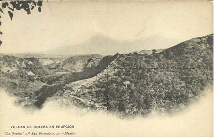
Colima Volcano Erupting. Postcard, La Joyita, ca 1905

This early postcard (cerca 1905) shows smoke billowing from Colima Volcano.

Colima Volcano Erupting. Postcard, La Joyita, ca 1905

Colima Volcano Erupting. Postcard, La Joyita, ca 1905

The postcard was published by a curio store – La Joyita – based in downtown Mexico City at 1ra de San Francisco #13-14. Described by The Mexican Herald in 1898 as one “of the most interesting stores for visitors to be found in the Republic”, it was one of two stores belonging to F. Pardal and Co. and specialized in Mexican opals, drawn work, silver filigree, and other items as well as ancient French and Spanish fans and silk shawls.

For more information about Mexico’s volcanoes:

Review of “Poor Economics: A Radical Rethinking of the Way to Fight Global Poverty”

 Books and resources, Mexico's geography in the Press  Comments Off on Review of “Poor Economics: A Radical Rethinking of the Way to Fight Global Poverty”
Oct 292019
 

In honor of the award of the 2019 Nobel Prize for Economics to Abhijit Banerjee, Esther Duflo and Michael Kremer for their experimental approach to alleviating global poverty, we republish this post from five years ago in which we highlighted the significance of the pioneering work of Banerjee and Duflo:

Every so often a book comes along that shakes up established wisdom and forces us to rethink our viewpoints and beliefs. The latest such book to cross my desk is Poor Economics: A Radical Rethinking of the Way to Fight Global Poverty by Abhijit V. Banerjee and Esther Duflo, published by PublicAffairs in 2011.

Geo-Mexico is reader-supported. Purchases made via links on our site may, at no cost to you, earn us an affiliate commission. Learn more.

poor-economicsThis is a worthy read for anyone interested in development theory, policy, practice and economics. The authors are professors of Economics at the Massachusetts Institute of Technology (MIT) and co-founded the Abdul Latif Jameel Poverty Action Lab (J-PAL). Their book reports on the effectiveness of solutions to global poverty using an evidence-based randomized control trial approach.

Banerjee and Duflo argue that many anti-poverty policies have failed over the years because of an inadequate understanding of poverty. They conclude that the battle against poverty can be won, but it will take patience, careful thinking and a willingness to learn from evidence.

The authors look at some of the unexpected questions related to poverty that empirical studies have thrown up, such as :

  • Why do the poor (those living on less than 99 cents a day) need to borrow in order to save?
  • Why do the poor miss out on free life-saving immunizations but pay for drugs that they do not need?
  • Why do the poor start many businesses but do not grow any of them?

The book was supported by an outstanding website that included:

  • Introductions to each chapter
  • Maps showing cited studies with links to original sources
  • Data and figures used with interactive data tools
  • A “What Can You Do” page with links to major organizations working in the field or for the problem discussed in the chapter

The website’s links to research papers mentioned in the book included four studies related to Mexico:

1. Do Conditional Cash Transfers Affect Electoral Behavior? Evidence from a Randomized Experiment in Mexico, by Ana L. De La O.

The evidence comes from the pioneering Progresa, the original Mexican conditional cash transfer (CCT) program (since repackaged as Oportunidades).  This CCT program led to a 7% increase in turnout and a 16% increase in the  incumbent vote share, with clear implications for politicians in areas where CCT programs reach a large percentage of voters.

2 School Subsidies for the Poor: Evaluating the Mexican Progresa Poverty Program, by T. Paul Schultz of Yale University (August 2001).

This study considered how a CCT program affected school enrollment. The CCT program increased enrollment in school in grades 3 through 9, with the increase often greater for girls than boys. The cumulative effect was estimated to add 0.66 years to the baseline level of 6.80 years of schooling.

3 Experimental Evidence on Returns to Capital and Access to Finance in Mexico, by David McKenzie and Christopher Woodruff (March 2008)

Microenterprises are often unable to access suitable financing, even though they are responsible for employing a large portion of the total workforce. This experiment, which gave cash and in-kind grants to small retail firms, demonstrated that this additional capital generated large increases in profits, with the effects concentrated on those firms which were more financially constrained. The estimated return to capital was found to be at least 20 to 33 percent per month, three to five times higher than market interest rates.

4 Working for the Future: Female Factory Work and Child Health in Mexico, by David Atkin (April 2009)

Atkins’ paper found that children whose mothers lived in a town where a maquiladora (export factory) opened when the women were sixteen years old were much taller than those children born to mothers who did not have a similar opportunity. The effect was so large that “it can bridge the entire gap in height between a poor Mexican child and the “norm” for a well-fed American child.” (Poor Economics, 229)

The increase in height could not be fully explained by the changes in family income resulting from employment in a maquiladora. As Bannerjee and Duflo suggest, “Perhaps the sense of control over the future that people get from knowing that there will be an income coming in every month -and not just the income itself- is what allows these women to focus on building their own careers and those of their children. Perhaps this idea that there is a future is what makes the difference between the poor and the middle class.” (Poor Economics, 229)

Conclusion

Banerjee and Duflo’s positive message is that poverty can indeed be alleviated, but we need to take one small measurable step at a time with constant evaluation of whether or not particular policies are successful, based on evidence, not just on belief systems.

Poor Economics: A Radical Rethinking of the Way to Fight Global Poverty” deserves its place of honor alongside other such genuine classics as E.F. Schumaker’s “Small Is Beautiful: A Study of Economics As If People Mattered” (1973). It is a must-read for geographers, regardless of your political persuasion.

Note: this is a lightly edited version of a post first published 27 January 2014.

Related posts

Mexico mis-map #1: Mazatlán Tourist Brochure

 Other  Comments Off on Mexico mis-map #1: Mazatlán Tourist Brochure
Sep 092019
 

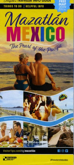
Graphic designers often taken liberties with maps. Nowhere is this more apparent than in this otherwise beautiful tourism brochure promoting the Pacific Coast resort of Mazatlán, collected recently in British Colombia, Canada.

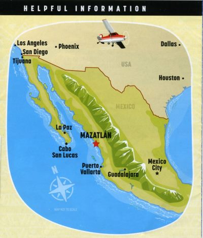
Here is the map in question:

Mexico’s relief, as shown on this map, is highly distorted. Accepting that the graphical designer was only interested in relief along the western side of Mexico given that the brochure is about Mazatlán, depicting a single massive range of mountains running from northern Mexico to Oaxaca is completely inaccurate.

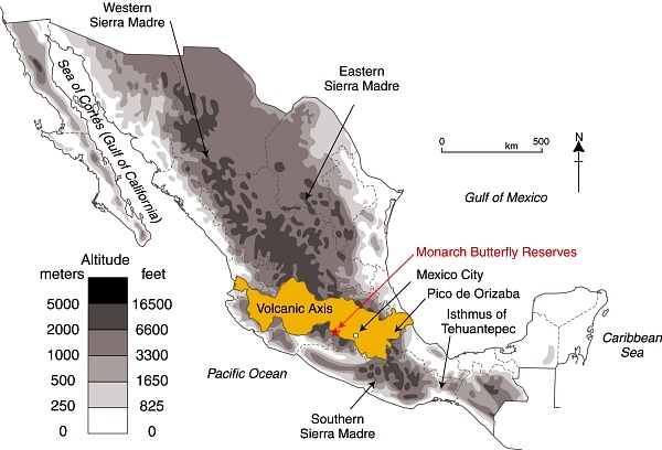
By way of comparison, here is a map we used previously to pinpoint the Monarch Butterfly reserves in the Volcanic Axis of Mexico. This map is based on the much more accurate relief map of Mexico from Geo-Mexico: the geography and dynamics of modern Mexico:

Location of Volcanic Axis and Monarch Butterfly reserves

Location of Volcanic Axis and Monarch Butterfly reserves. Basemap: Figure 3.1 of Geo-Mexico; all rights reserved.

The book is still in print. Buy your copy today, especially if you are a graphic designer about to take unwarranted liberties with any map of Mexico!

Aug 232019
 

A recent edition of the New Scientist has an interesting article about dinosaurs and the rapid shifts in our knowledge of these ancient beasts based on recent fossil discoveries. If the New Scientist is to be believed, these discoveries have not only revolutionized our views of dinosaurs, they have also rearranged the Earth’s geography.

  • The demise of the dinosaurs came about after “An enormous asteroid struck what is now the Yucatan peninsula  in Central America, sparking a mass extinction.”

Hmm… first up, it should be the “Yucatán Peninsula” (with an uppercase “P”) to refer to that region of Mexico. And, more importantly, the Yucatán Peninsula, as part of Mexico, is clearly in North America, not Central America, unless the impact of that danged asteroid is still reverberating around the world and shifting the continents.

For more about dinosaurs and the Chicxulub impact crater –

Source:

  • Riley Black. “The undiscovered dinosaurs”. New Scientist, August 3-9, 2019, page 46

How well do you know Mexico? Quiz 1

 Other  Comments Off on How well do you know Mexico? Quiz 1
May 172019
 

Welcome to your How well do you know Mexico? QUIZ 1

1. 
Which of the following is the largest state (in area) in Mexico?

2. 
What was Mexico's total population in 2020, according to the 2020 Census?

3. 
On average, how many people live in a household in Mexico?

4. 
Which of the following is the odd one out, and why?

5. 
Which of the five states shown on the map is Guerrero?

6. 
The waterfall once known as the "Niagara of Mexico" is close to which of these cities?

7. 
In which year was Mexico City hit by a magnitude 8.1 earthquake?

8. 
What is the name of the main indigenous group living in Mexico's Copper Canyon region?

9. 
At current rates of extraction, how long will Mexico's 3P (proven, probable, possible) reserves of crude oil last?

10. 
When did construction begin of Cancún, the major tourist resort in Quintana Roo?

BBC’s Fiona Bruce has no clue where Mexico is and enters Geo-Mexico’s “Hall of Shame”

 Other  Comments Off on BBC’s Fiona Bruce has no clue where Mexico is and enters Geo-Mexico’s “Hall of Shame”
Apr 232019
 

The BBC has done it again! Not content with its previous entry in Geo-Mexico’s “Hall of Shame” for its TV documentary “Racing Green”, it now qualifies for a second entry for an episode of “Fake or Fortune.”

Fiona Bruce – yes, the Oxford-educated journalist and newsreader and current host of Antiques Roadshow and other noteworthy BBC programmes – apparently believes that Mexico is in South America.

In 2016, episode 3 of series 5 of “Fake or Fortune” investigated the authenticity of an alleged Rodin watercolor of a Cambodian dancer that was given to the owner’s mother in Mexico City in about 1940 by restaurant owner Jimmy Heineman in exchange for some artwork.

The owner’s mother, Suzanne Daco, was a moderately successful artist who held at least one solo exhibit of her work in Mexico City. The exhibition was reviewed at the time for Hoy, the illustrated Mexico City magazine.

Referring to the review, Fiona Bruce commented that it had appeared in Hoy, “one of the top magazines across the whole of the South American continent.” South America? Err… no! Schoolgirl howler from distinguished BBC journalist?  Err… yes!

Congratulations, Ms Bruce! You are the latest entrant to Geo-Mexico’s Hall of Shame. And, congratulations, BBC, you become the first organization to have two entrants in our Hall of Shame.

Program transcript: https://www.tvo.org/transcript/122675X/ep-3-rodin

Related posts:

Mexico’s Day of the Dead: nine of the best places to visit

 Other  Comments Off on Mexico’s Day of the Dead: nine of the best places to visit
Oct 162018
 

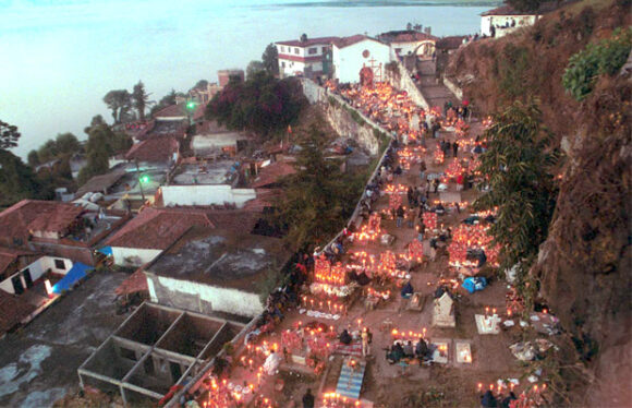
Celebrations for Mexico’s Day of the Dead (Día de Muertos) or, more correctly Night of the Dead (Noche de Muertos), date back to pre-Hispanic times. Indigenous Mexican peoples held many strong beliefs connected with death; for example that the dead needed the same things as the living, hence their bodies should be buried with their personal possessions, sandals and other objects.

With the arrival of the Spanish, the Indians’ pagan ideas and customs were gradually assimilated into the official Catholic calendar. Dead children (angelitos) are remembered on November 1st, All Saints’ Day, while deceased adults are honored on November 2nd, All Souls’ Day. On both days, most of the activity takes place in the local cemetery.

In many locations, festivities (processions, altars, concerts, meals, dancing, etc) now last several days, often beginning several days before the main days of November 1st and 2nd.

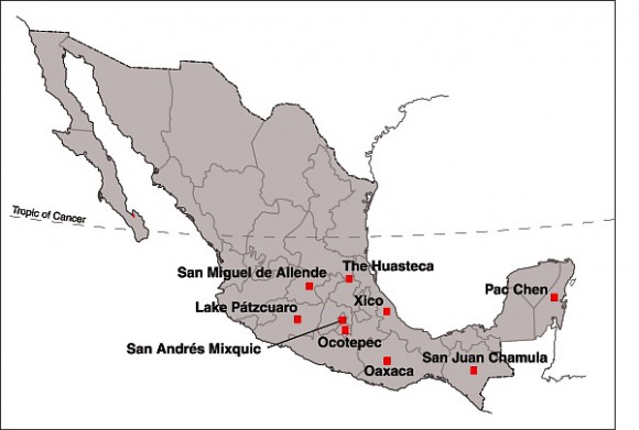
Day of the Dead: Top Nine Locations

Day of the Dead: Top Nine Locations

The Day of the Dead was designated an “intangible world heritage” by UNESCO in 2008. The official UNESCO description of Mexico’s “Indigenous Festivity dedicated to the Dead” summarizes its significance:

“As practised by the indigenous communities of Mexico, el Día de los Muertos (Day of the Dead) commemorates the transitory return to Earth of deceased relatives and loved ones. The festivities take place each year at the end of October to the beginning of November. This period also marks the completion of the annual cycle of cultivation of maize, the country’s predominant food crop.”

“Families facilitate the return of the souls to Earth by laying flower petals, candles and offerings along the path leading from the cemetery to their homes. The deceased’s favorite dishes are prepared and placed around the home shrine and the tomb alongside flowers and typical handicrafts, such as paper cut-outs. Great care is taken with all aspects of the preparations, for it is believed that the dead are capable of bringing prosperity (e.g. an abundant maize harvest) or misfortune (e.g. illness, accidents, financial difficulties) upon their families depending on how satisfactorily the rituals are executed. The dead are divided into several categories according to cause of death, age, sex and, in some cases, profession. A specific day of worship, determined by these categories, is designated for each deceased person. This encounter between the living and the dead affirms the role of the individual within society and contributes to reinforcing the political and social status of Mexico’s indigenous communities.”

The Day of the Dead celebration holds great significance in the life of Mexico’s indigenous communities. The fusion of pre-Hispanic religious rites and Catholic feasts brings together two universes, one marked by indigenous belief systems, the other by worldviews introduced by the Europeans in the sixteenth century.”

Here, in no particular order, are 9 of the best places to visit for Mexico’s Day of the Dead:

1. Michoacán

The single best-known location for Day of the Dead in the entire country is the Island of Janitzio in Lake Pátzcuaro, Michoacán. This is one of Mexico’s most famous major annual spectacles. Thousands of visitors from all over the world watch as the indigenous Purepecha people perform elaborate rituals in the local cemetery late into the night. Yes, it has become commercialized, but it remains a memorable experience, and also offers the opportunity to sample the local cuisine, which itself was declared an “intangible world heritage” by UNESCO in 2010!

Janitzio cemetery

Janitzio cemetery

Several other locations in the Lake Pátzcuaro area, including Ihuatzio, Tzintzuntzan, Arocutín and Jarácuaro, offer their own equally memorable (but less visited) festivities and rituals. Interesting observances of Day of the Dead also occur in many other places in Michoacán, including Angahuan (near Paricutin Volcano) and Cuanajo.

2. Mexico City

Two locations in the southern part of the city are well worth visiting for Day of the Dead.

In San Andrés Mixquic, which has strong indigenous roots, graves are decorated with Mexican marigolds in a cemetery lit by hundreds and hundreds of candles. Street stalls, household altars and processions attract thousands of capitalinos each year.

In Xochimilco, the canals and chinampas are the background for special night-time Day of the Dead excursions by boat (trajinera).

3. Morelos

Ocotepec, on the outskirts of Cuernavaca, is another excellent place to visit for Day of the Dead activities.

4. Veracruz

Xico, one of Mexico’s Magic Towns, has colorful Day of the Dead celebrations, including a flower petal carpet along the road to the graveyard. Don’t miss sampling the numerous kinds of tamales that are a mainstay of the local cuisine.

5. San Luis Potosí and Hidalgo

In the indigenous Huastec settlements of the mountainous area shared by the states of San Luis Potosí and Hidalgo, the celebrations for Day of the Dead are known as Xantolo. Multi-tiered altars are elaborately decorated as part of the festivities.

6. Chiapas

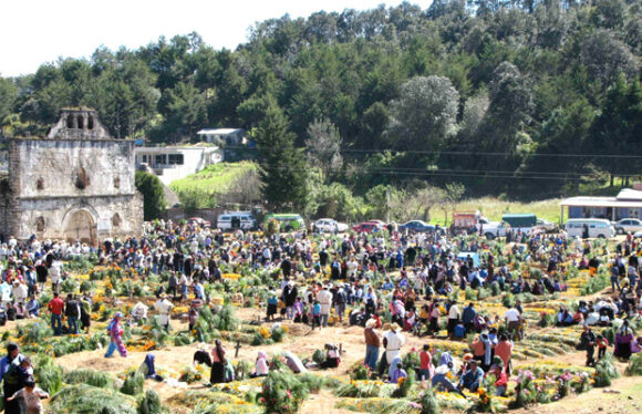
Several indigenous communities in Chiapas celebrate the Day of the Dead in style. For example, in San Juan Chamula, the festival is known as Kin Anima, and is based on the indigenous tzotzil tradition.

San Juan Chamula

San Juan Chamula

7. Yucatán and Quintana Roo

In the Maya region, Day of the Dead celebrations are known as Hanal Pixan, “feast for the souls.” Families prepare elaborate food for the annual return of their dearly departed. The cemeteries in the Yucatán capital Mérida are well worth seeing, as are the graveyards in many smaller communities. See, for example, this account of the festivities in Pac Chen, Quintana Roo: Hanal Pixan, Maya Day of the Dead in Pac Chen, Quintana Roo

Tourist locations offer their own versions of Day of the Dead celebrations. For example, Xcaret theme park, in the Riviera Maya, is the scene of the Festival of Life and Death (Festival de la Vida y la Muerte) featuring parades, rituals, concerts, theater performances and dancing.

8. Oaxaca

There are rich and varied observances of Day of the Dead in the state of Oaxaca. Visitors to Oaxaca City can witness vigils in several of the city’s cemeteries and night-time processions called comparsas. The celebrations are very different on the Oaxacan coast, as evidenced by this account of Day of the Dead in Santiago Pinotepa Nacional.

9. Guanajuato
The city of San Miguel de Allende in Guanajuato holds an annual four-day festival known as “La Calaca” with artistic and cultural events that are “integrated into the vibrant celebration of life and death known as Dia de Muertos”.

In Mexico, the age-old cultural traditions of Day of the Dead are still very much alive!

Note for armchair travelers

Besides the usual travel accounts describing Day of the Dead, there are numerous children’s and adult novels including vivid accounts of typical Day of the Dead activities. There are also various novels entitled Day of the Dead, though not all of them are focused on the Mexican tradition. One of the earliest of the novels entitled Day of the Dead is Bart Spicer’s 1955 spy novel, Day of the Dead, which has several scenes in Chapala, Guadalajara and Mexico City.

Related links:

Ten new “Magic Towns” have been announced

 Mexico's geography in the Press  Comments Off on Ten new “Magic Towns” have been announced
Oct 122018
 

Ten new “Magic Towns” have been announced, bringing the total number nationwide to 121. The lates additions are:

  • Melchor Múzquiz, Coahuila
  • Nombre de Dios, Durango
  • Comonfort, Guanajuato
  • Zimapán, Hidalgo
  • Tlaquepaque, Jalisco
  • Compostela, Nayarit
  • Amealco de Bonfil, Querétaro
  • Aquismón, San Luis Potosí
  • Bustamante, Nuevo León
  • Guadalupe, Zacatecas

See also:

Incoming administration has decentralization plans

 Mexico's geography in the Press  Comments Off on Incoming administration has decentralization plans
Oct 022018
 

Several previous administrations have tried to decentralize Mexico, encouraging businesses to set up in the “periphery” away from the “core” of Mexico City and central Mexico. The incoming administration has announced its intention to move several federal government Secretariats away from Mexico City. The plans are discussed in some detail in this interesting article by Simon Schatzberg:

Mexico celebrates 208 years of independence

 Other  Comments Off on Mexico celebrates 208 years of independence
Sep 142018
 

Happy birthday, Mexico! On 16 September 2018, Mexico celebrates the 208th anniversary of its independence from Spain.

Mexican flag

Geo-Mexico is reader-supported. Purchases made via links on our site may, at no cost to you, earn us an affiliate commission. Learn more.

When was Mexico’s War of Independence?

The long struggle for independence began on 16 September 1810; independence was finally “granted” by Spain in 1821.

Want some map-related geographic trivia associated with the War of Independence?

Events in the War of Independence called for an accurate map of Lake Chapala, Mexico’s largest natural lake. The cartographer for this map was José María Narváez, whose major contributions to Mexican cartography in succeeding decades have largely been forgotten.

The first truly national map, compiled in 1857-1858 from a meticulous reconciling of the work of numerous local cartographers, was drawn by Antonio García Cubas. García Cubas did not graduate from university until a few years after completing this map!

Nationalism and the start of Mexico-USA migration, but not in the direction you might think…

Following independence, the rush was on to draw an accurate map of all of Mexico’s territory. Mexico’s boundaries following independence were very different to today. Flows of migrants linking the USA to Mexico at that time were from the USA to Mexico, the reverse of the direction of more recent flows, which have seen millions of Mexicans migrate north looking for work:

Some national symbols are not quite what you might think, either!

The story of the national emblem (used on coins, documents and the flag) of an eagle devouring a serpent, while perched on a prickly-pear cactus, is well known. Or is it?

Why is “El Grito” held on the night of 15 September each year?

In 1910, then president Porfirio Díaz decided that the centenary of Mexican independence should be celebrated in style. One of the reasons why the “traditional” Grito (“shout”) is made on 15 September each year, rather than on the morning of 16 September (when Father Miguel Hidalgo apparently gathered his parishioners in revolt) is because 15 September 1910 happened to be Díaz’s 80th birthday. Why not have one big bash and celebrate both president and country at the same time? Even though the Mexican Revolution broke out later that year (and Díaz was later exiled to Paris), Mexico continues to start its annual independence-day celebrations on the evening of 15 September.

Not to be confused with Cinco de Mayo (5 May)

Many people incorrectly assume that Cinco de Mayo (5 May) is Mexico’s independence day. The Cinco de Mayo has nothing to do with Independence, but everything to do with a famous victory over the French. It commemorates the Battle of Puebla, fought on May 5, 1862. The battle marks Mexico’s only major military success since independence:

Independent country, independent book:

Mexico has come a long way in 200 years, but amazingly, to the best of our knowledge, Geo-Mexico: the geography and dynamics of modern Mexico, is the first-ever book in English focused exclusively on the nation’s varied and fascinating geography.

¡Viva Mexico!

Mexican flag

Aug 282018
 

For anyone who continues to doubt the potentially disastrous impacts of building a wall along the U.S.-Mexico border on wildlife (let alone people), then perhaps these two articles will help you decide which side of the fence you want to be on:

See also:

Geo-Mexico wishes you a Happy Cinco de Mayo (5 May)!

 Other  Comments Off on Geo-Mexico wishes you a Happy Cinco de Mayo (5 May)!
May 032018
 

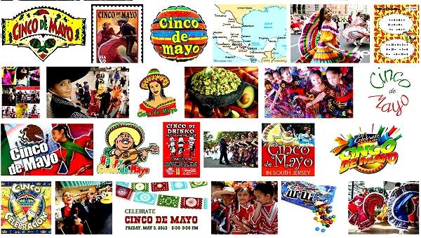
The holiday of Cinco de Mayo (5 May) commemorates the Battle of Puebla, fought on May 5, 1862. The battle (against the French) marks Mexico’s only major military success since its independence from Spain in 1821. Today, in a curious example of cultural adaptation, the resulting holiday is actually celebrated more widely in the USA than in Mexico!

Cinco de Mayo: Google image search results

Cinco de Mayo: Google image search results

For an account of the history behind the Cinco de Mayo, and for an explanation of why the holiday is now celebrated more in the USA than in Mexico:

In Mexico, Cinco de Mayo is celebrated with a parade in the City of Puebla each year, but, in another strange twist of geography,  the longest-running annual re-enactment takes place in Mexico City:

Want to read more?

MexConnect has several informative articles relating to Cinco de Mayo, including:

New museum in Yucatán will explain Chicxulub Crater and demise of the dinosaurs

 Mexico's geography in the Press  Comments Off on New museum in Yucatán will explain Chicxulub Crater and demise of the dinosaurs
Feb 132018
 

A new museum 40 kilometers northwest of the Yucatán state capital – Mérida – is expected to open later this year to explain the nearby Chicxulub Crater, created by an asteroid impact 65 million years ago, and believed to be responsible for the demise of the dinosaurs.

Dec 242017
 

Some parts of Mexico have been working on Christmas for most of the year… For example, the manufacturing of beautiful handmade Christmas tree decorations is the main industry today in the former gold and silver mining town of Tlalpujahua in the state of Michoacán. The production of Christmas ornaments in Tlapujahua has a great series of photos by Arturo Toraya of Notimex, showing some of the steps involved.

ornaments-2

As the accompanying text explains, “Making baubles for Christmas trees is the main source of jobs in the town, which is now one of the top five producers in the world. Due to their quality, 90 percent of the total production is exported to the U.S. and Canada. There are 200 family workshops in the town with seven-hour shifts, and each worker can make up to 550 baubles per day. Each workshop decorates about 500 per day. Red, blue, green and yellow are the top selling colors in Mexico, while black, brown and grey are more popular in the U.S.”

The village of Tzintzuntzan, on the shores of Lake Pátzcuaro, also in Michoacán, is another settlement where Christmas seems to be a year-round source of inspiration. The village handicraft market is a cornucopia of straw work in every conceivable color, design and size, which make ideal Christmas decorations or gifts.

Happy Christmas from Geo-Mexico! – ¡Feliz Navidad!

Craft market in Tzintzuntzan, Michoacan

Craft market in Tzintzuntzan, Michoacan

Related posts:

Dec 092017
 

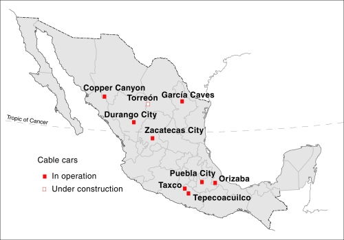
There are now at least nine cable cars (teleféricos) for tourism operating in Mexico :

  • Durango City, Durango
  • Copper Canyon (Barrancas del Cobre), Chihuahua
  • García Caves (Grutas de García), Nuevo León
  • Zacatecas City, Zacatecas
  • Hotel Montetaxco, Taxco, Guerrero
  • Hotel Vida en el Lago, Tepecoacuilco, Guerrero
  • Orizaba, Veracruz
  • Puebla City, Puebla
  • Torreón, Coahuila

All these cable cars are primarily designed for sightseeing and tourism, rather than as a means of regular transport for local inhabitants. In addition, there is at least one urban cable car in the Mexico City Metropolitan Area designed for mass transit:

Mexico-Cable-Cars

Durango City

The Durango teleférico, inaugurated in 2010, is 750 meters long. It links Cerro del Calvario in the historic center of the city with the viewpoint of Cerro de Los Remedios. It cost about $70 million to build and its two gondola cars can carry up to 5000 people a day. Parts of the ride are some 80 meters above the city. The system was built by a Swiss firm and is one of only a handful of cable cars that start from a historic city center anywhere in the world. (The Zacatecas City cable car is another).

Copper Canyon (Barrancas del Cobre) in the state of Chihuahua

The Copper Canyon teleférico starts alongside Divisadero railway station in Mexico’s famous Copper Canyon region, and runs 2.8 km across a section of canyon, up to 400 meters above the ground level. Inaugurated in 2010, it is the longest cable car in Mexico, cost $25 million and can carry 500 passengers an hour, using two cabins (one traveling in each direction), each able to hold 60 people. It is a 10-minute ride each way to the Mesa de Bacajipare, a viewpoint which offers a magnificent view of several canyons.

García Caves (Grutas de García) in Nuevo León

The Garcia Caves are located in the Cumbres de Monterrey National Park, 9 km from the small town of García, and about 30 km from the city of Monterrey. The caves are deep inside the imposing Cerro del Fraile, a mountain whose summit rises to an elevation of 1080 meters above sea level, more than 700 meters above the main access road. The entrance to the caves is usually accessed via a short ride on the 625-meter teleférico, which was built to replace a funicular railway.

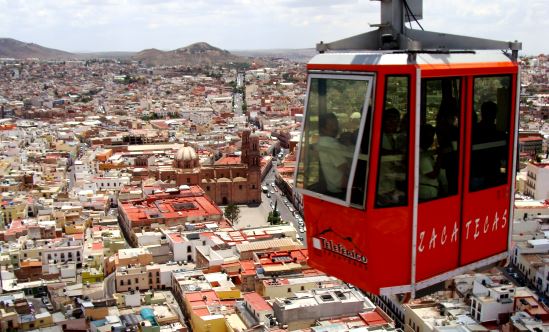
zacatecas-teleferico

Zacatecas City

The Zacatecas teleférico, opened in 1979, is 650 meters long and links the Cerro del Grillo, near the entrance to the El Eden mine on the edge of the city’s historic center, with the Cerro de la Bufa. It carries 300,000 people a year high over the city, affording splendid views of church domes, homes, narrow streets and plazas during a trip that lasts about ten minutes. On top of Cerro de la Bufa is an equestrian statue of General Doroteo Arango (aka “Pancho” Villa), commemorating 23 June 1914, when he and his troops successfully captured the city after a nine-hour battle.

La Bufa is also the setting for a curious children’s New Year legend involving a giant cave housing a great palace with silver floors, gold walls, and lights of precious stones. This palace is inhabited by thousands of gnomes, whose job is to look after the future “New Years”. Each December the gnomes choose which “New Year” will be given to the world outside… (For the full story, see chapter 21 of my Western Mexico, A Traveler’s Treasury)

Hotel Montetaxco, in Taxco, Guerrero

This hotel teleférico is a convenient link between the hotel, set high above the city, and the downtown area of this important tourist destination, best known for its silver workshops.

Hotel Vida en el Lago, in Tepecoacuilco, Guerrero

A second hotel in Guerrero also has its own teleférico, running from the hotel to a viewpoint atop the Cerro del Titicuilchi.

Orizaba, Veracruz

Cable car in Orizaba, Mexico

A 950-meter-long cable car, using 6-person cabins (see image), began operations in the city of Orizaba in Veracruz in December 2013. The cable car goes from Pichucalco Park, next to the City Hall in downtown Orizaba, to the summit of Cerro del Borrego. which overlooks the city. The 8-minute ride affords outstanding views over the city center.

Puebla City

Initial construction of the teleférico in the city of Puebla, in central Mexico, was halted in 2013, amidst considerable controversy about its route and the demolition of a protected, historic building (the Casona de Torno) in this UNESCO World Heritage city. The original route was 2 kilometers long and linked the historic center of Puebla with a nearby hill, home to the forts of Loreto and Guadalupe. In 1862, these forts were the site of the famous Battle of Puebla, at which Mexican forces proved victorious over the French, a victory celebrated each year on 5 May (Cinco de Mayo).

When it proved impossible to inaugurate this cable car in time for Mexico’s 2013 Tourist Tianguis (the largest tourism trade fair in Latin America), authorities boarded up the partially-completed structures (3 metal towers and 2 concrete bases) to completely hide them from public view. Construction resumed in 2014, but only of a 688-meter-long stretch which cost $11 million to build. This section, which includes a tower in Centro Expositor, the city’s main exhibition center, was officially opened in January 2016. The 5-minute ride costs about $30 pesos ($1.60) each way.

Torreón, Coahuila (opened December 2017)

Italian firm Leitner Ropeways constructedTorreón’s cable car. (Leitner built Mexico’s first cable car for regular urban transit in Ecatepec in the State of Mexico). The Torreón cable car runs 1400 meters between Paseo Morelos in the downtown area and the Cerro de las Noas, site of the large sculpture El Cristo de las Noas, reputedly the largest statue of Christ in North America.

The system will initially have nine 8-pasenger cabins giving a capacity of about 380 passengers an hour each way. The cable car cost between $9 million and $10 million. It was originally due to enter service in December 2016 but finally opened in December 2017. Users pay about 3 dollars for a round trip (about 5 minutes each way). City officials hope its completion will provide a welcome boost to Torreón’s fledgling tourism sector.

[Note: This is an updated version of a post first published in 2014]

Related posts:

Mexican farmers grow Christmas trees that can be replanted

 Other  Comments Off on Mexican farmers grow Christmas trees that can be replanted
Nov 162017
 

Mexican farmers in Tlaxcala are now growing their own Christmas trees. Environmentally-conscious consumers can purchase them, decorate them, and then replant in their gardens! Times are changing! Enjoy ~

Modern Mexican Nacimiento. Photo: Ariaski (Flickr);

Modern Mexican Nacimiento. Photo: Ariaski (Flickr); creative commons license

Previous Geo-Mexico posts related to Christmas:

Jul 102017
 

There are press reports of red-hot rocks emerging last weekend at a location known as “Pueblo Viejo” in the municipality of Venustiano Carranza in the state of Michoacán, a short distance east of Lake Chapala. That location is not far from the famous mud volcanoes, “Los Negritos” at Villamar, described in chapter 6 of my book Western Mexico: A Traveler’s Treasury.

Note: Please note that this is an on-going event; this post will be updated and, if necessary, rewritten, as further information becomes available.

The reports say activity began on Saturday 8 July 2017. Cracks and fissures have appeared in the middle of a soccer pitch in Pueblo Viejo, and smoke, vapor and red-hot rocks emitted. Some reports refer to two goats having been found burned to a crisp, and say that subsoil temperatures up to 250 degrees Celsius have been recorded.

Short video related to this event: http://www.hoyestado.com/2017/07/

Expert geologists are on their way to assess the situation and try to determine the cause and potential impacts.

Update – 11 July 2017:

Panic over! Geologists from UNAM have discounted the possibility that this is the birth of a new volcano and determined that this is a “geothermal fault” giving rise to a phenomenon that is more similar to the fumaroles found in some areas where volcanoes were previously active. The Lake Chapala area is part of Mexico’s Volcanic Axis which was very tectonically active millions of years ago.

This screenshot of Google Maps shows the approximate location:

The most famous new volcano in historic times is Paricutín Volcano, located further east in Michoacán. Parictuín was active between 1943 and 1952.

Mexico's Volcanic Axis (Fig 2.2 of Geo-Mexico, the geography and dynamics of modern Mexico. All rights reserved.

Mexico’s Volcanic Axis (Fig 2.2 of Geo-Mexico, the geography and dynamics of modern Mexico. All rights reserved.

Press reports (Spanish:

Related posts: