The growth of the city of Monterrey, Mexico’s industrial powerhouse

 Excerpts from Geo-Mexico, Other  Comments Off on The growth of the city of Monterrey, Mexico’s industrial powerhouse
Oct 282013
 

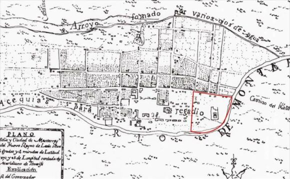
A series of historical maps of the city of Monterrey was published earlier this year in the city’s online Catalog of Buildings of Historic and Artistic Importance in Barro Antiguo, The maps, dated 1765, 1791, 1846, 1865, 1922, 1933 and 1947 respectively, offer a good basis for considering the urban growth of Monterrey, the industrial powerhouse of northern Mexico.

In chapter 22 of Geo-Mexico, the geography and dynamics of modern Mexico, we explained why, “Monterrey does not fit the general Latin American urban model as well as Mexico City or Guadalajara. First, it never really existed as a colonial city. Secondly, its development was more heavily dependent on industry. Thirdly, its relative wealth and progressive leadership in some ways make it more similar to a North American city than a Latin American city. It fits the model only in that it developed a definite high status sector in contrast to lower status industrial sectors, and eventually became spatially fragmented.”

But just how did Monterrey develop as a city? In each of the following historical maps of Monterrey, Barrio Antiguo (16 blocks in size in the present-day city) is marked by a red quarter-circle, which is an easy way to check each map’s orientation and scale. Monterrey was founded in 1596. The earliest map in our series, for 1765, shows that, even by that date, Monterrey was still a relatively small settlement situated between a (seasonally dry) “stream formed by various springs” (to the top of the map, north) and the seasonally-dry “Monterrey River” (now called the Santa Catarina River). The Barrio Antiguo is shown as mostly an empty area, with only one major construction.

Monterrey 1765

Monterrey 1765

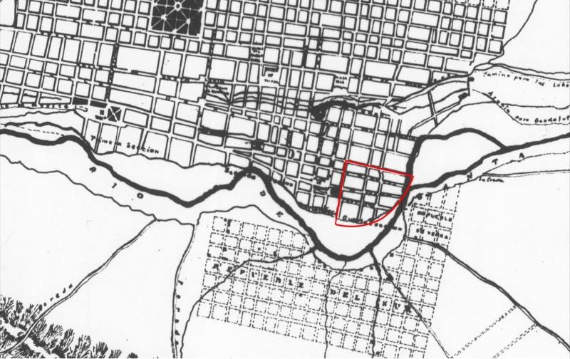
Very little has changed by 1791 (see map below: note that this map is oriented south-upwards), though the Barrio Antiguo has now been developed, and is shows as having several streets in a clear grid pattern:
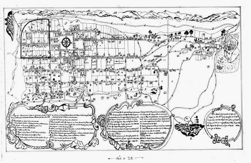
monterrey-1791

Monterrey in 1791

The grid pattern for Barrio Antiguo is equally evident in the details of the map in 1846:
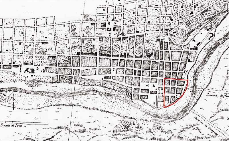
monterrey-1846

Monterrey in 1846

As of 1846, no development is shown on the south bank of the Santa Catarina River, though tracks are shown heading east and south-east respectively from the city. The next map, for 1865, shows that the city is beginning to expand to the south. A substantial settlement is developing on the south bank, more of less opposite the Barrio Antiguo. Note, though, that this map shows only part of the city:

monterrey-1865

Monterrey in 1865

Clearly, Monterrey only emerged as a real city after the colonial period which ended in 1821. The relatively small city did not experience real growth until late in the 19th century when it became connected by railroad and started to attract industrial development.

Early in the 20th century, investors built the then largest iron and steel works in Latin America a few kilometers east of the city center. Many related industries located nearby. These industries and the railroad, which ran east–west about four kilometers (2.5 mi) north of the city center, stimulated early industrial development in these directions. Developers established low income housing tracts for industrial and other workers on the east, north and west periphery of the city. Neighborhoods for the wealthier classes were developed south of the city center.

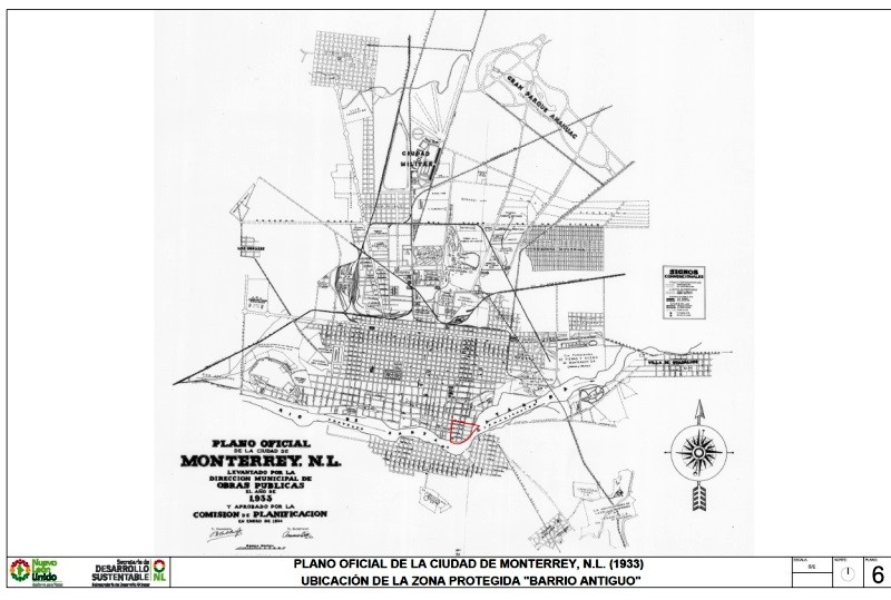
By 1933, Monterrey has grown significantly in area, especially towards the north:

monterrey-1933-whole-city

The city of Monterrey in 1933

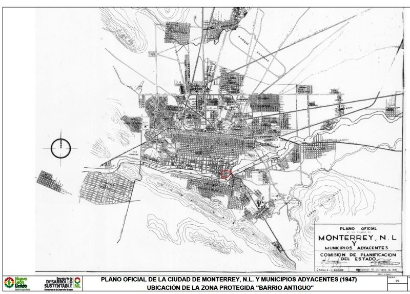
Between 1933 and 1947, the city continues to expand, with many areas being infilled with residences:

monterrey-1947

The city of Monterrey in 1947

The city experienced another surge of industrialization and immigration in the 1950s and 1960s. Industrial development continued after 1970 when the national government implemented policies to shift development away from Mexico City. Monterrey became a major producer of steel, metal fabrication, cement, beverages, petrochemicals, food, telecommunications, auto parts, glass, and house furnishings. It also developed into a major financial center and one of the wealthiest and most progressive cities in the country.

Low income housing became a serious problem after the 1960s as the inner city tenements became extremely crowded. The government was not sympathetic to irregular housing schemes, so low income groups established numerous illegal squatter settlements on vacant land near the industrial zone. Government made a few efforts to remove these, but most survived and eventually became regularized.

The high status sector expanded south-west into San Pedro Garza García, which became one of the wealthiest municipalities in Mexico. The high overall income and wages in the city meant that many workers could afford home ownership and private automobiles. As a result, many gated communities (large and small) and suburban shopping malls were built around the urban periphery. The urban area became relatively fragmented with many low income residential zones located near high income areas.

Source of the maps used in this post:

Other posts about the urban geography of Mexico’s cities:

Survey in March 2013 identifies crime as Mexico’s biggest public concern

 Mexico's geography in the Press  Comments Off on Survey in March 2013 identifies crime as Mexico’s biggest public concern
Oct 262013
 

The Pew Research Global Attitudes Project (released 24 October 2013) provides results of face to face interviews with a national sample of 1,000 adult Mexicans. The report revealed opinions concerning a wide variety of issues including the country’s direction, most important concerns, law and order, drug war, national institutions and attitudes toward the USA. Mexicans are generally dissatisfied with their country. In March 2013, 69% of Mexicans said they were dissatisfied, up from 63% in 2012, but down from 79% in 2010. The survey suggests that crime is a major cause for dissatisfaction.

The biggest concern identified in the survey is crime which 81% said was a very big problem, up from 73% in 2012. Several other crime-related issues topped the very big problem list: cartel-related violence (71%), illegal drugs (70%), human rights violations by the military and police (70%) and corrupt political leaders (69%). The concern for crime causes real fear. The survey noted that 63% say they are afraid to walk alone at night within one kilometer of their home, up 7% from 2012 and 13% from 2007. Women were only slightly more concerned about their safety than men (65% versus 60%). Those in urban areas were significantly more worried about safety than those in rural areas (70% versus 43%). On the other hand, the fact that over four in ten in rural areas were worried is both surprising and startling.

Unfortunately, we do not have a complete regional breakdown of the survey respondents. We speculate that crime is perceived as a bigger problem in high crime areas such as the north. Attitudes toward bribery appear to support this view. While 32% said they had to pay a bribe to a government official in the past year; the percentages ranged from 51% in the north to 18% in the Mexico City Region.

Over two-thirds (68%) felt that government should focus on maintaining law and order rather than protecting human rights (18%). Only 11% said that both were equally important. It is interesting that respondents from all three major political parties gave almost equal high priority to law and order: Party of the Democratic Revolution (PDR) – 66%; National Action Party (PAN) – 69% and Institutional Revolutionary Party (PRI) – 70%.

The drug war continues to be a problem; only 37% think the government is making progress, compared to 47% in 2012. Fully 29% said the government is losing ground in the drug war and 30% think it is about the same as it has been in the past. Over half (56%) blame both Mexico and the USA for drug violence. Only 20% blame just the USA, while 17% blame just Mexico. The vast majority (85%) want the Mexican army to fight drug cartels and over half (55%) would like the US government to provide weapons and training to fight the drug war. Only 34% would like to have US troops in Mexico fighting the cartels.

Given that the drug war is not going well and the military is implicated in many human rights violations, it is surprising that 72% of survey respondents feel that the military has a good influence on Mexico. This was higher than any other institution. About 68% felt the national government has a good influence. Other institutions got lower scores: the media – 66%, President Peña Nieto – 57%, Congress – 45%, court system – 44%, and police – 42%.

Aside from crime and related issues, Mexicans identified several other major problems. About five in eight (63%) considered poor quality schools a very big problem, way up from 49% in 2012. This increase was probably related to the arrest of the teachers’ union president and focus on the dire need for education reform. Other very big problems were pollution (60%), terrorism (59%) and people leaving Mexico for jobs (53%). This last item is a bit surprising since in recent years (since the Great Recession) relatively few Mexicans have left in search of jobs.

The percentage viewing the USA favorably has changed considerably in recent years. In early 2010, before passage of Arizona’s restrictive immigration law, 66% viewed the USA favorably. After passage of the law, this dropped to 44%, compared to an unfavorable view of 48%, up from 27% before the law. Clearly passage of that law had a very big impact on Mexicans. However the favorable ratings increased to 52% in 2011, 56% in 2012 and 66% in 2013. Meanwhile the unfavorable ratings dropped to 41% in 2011, 34% in 2012 and 30% in 2013.

Only 17% said they had traveled to the USA, but 21% indicated their families received money from relatives north of the border. About 47% indicated that moving to the USA leads to a better life, while 18% say it leads to a worse life. However, 44% say having citizens living in the USA is bad for Mexico, an equal number say it is good for Mexico. Apparently, the view is that it is good for individuals to move to the USA, but such moves may not necessarily be good for Mexico as a whole. Consistent with this, 35% said they would move to the USA if they had the means and opportunity, 20% would migrate without authorization while 15% would only migrate if they had authorization.

It will be interesting to see how these opinions change when the 2014 survey is conducted.

Related posts:

Oct 242013
 

Mexico’s latest UNESCO World Heritage Site is the El Pinacate and Gran Desierto de Altar Biosphere Reserve in Sonora, added to the UNESCO list in June 2013. Mexico now has 32 World Heritage Sites.

The El Pinacate and Gran Desierto de Altar Biosphere Reserve is part of the Sonoran desert, which extends from Sonora into the northern part of Baja California, and across the U.S. border into Arizona and California. The reserve covers 714,566 hectares with an additional 354,871 hectares of buffer zone. It is a relatively undisturbed portion of the Sonoran desert, and offers visitors a dramatic combination of two very distinct landscape types: volcanic landscapes (El Pinacate) and sand dunes (Gran Desierto de Altar).

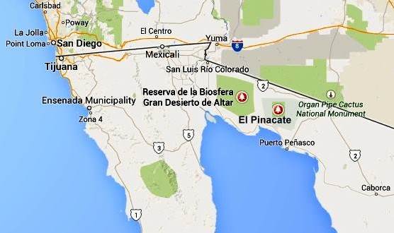
pinacate-map-googleThe biosphere reserve is immediately south of the U.S. border, west of the Lukeville (Arizona) – Sonoyta (Sonora) border crossing, and 50 km (30 miles) north of the fishing and tourist town of Puerto Peñasco. The San Luis Río Colorado–Sonoyta section of Mexican federal highway 2 (which runs from Mexicali to Caborca) skirts the northern section of the reserve. Puerto Peñasco is connected to Sonoyta by highway 8. There are entrances to the park from highway 2, 50 km west of Sonoyta, and from highway 8, mid-way between Sonoyta and Puerto Peñasco.

Despite being a desert area, most parts of the biosphere reserve do receive occasional rainfall, which gives this area more biodiversity than is true for most deserts.

El Pinacate and Gran Desierto de Altar Biosphere ReserveVaried scenery

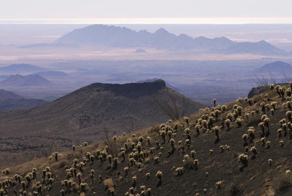
The eastern section of the biosphere reserve, El Pinacate, is a dormant volcanic area of around 200,000 ha (2000 sq. km), centered on the El Pinacate Shield (or Sierra Pinacate) which has lava flows, cinder cones, lava tubes and circular maars (steam explosion craters). Ron Mader, the founder of Planeta.com and a foremost authority on responsible tourism in Mexico, has marveled at the “bizarre and mind-boggling scenery” of El Pinacate. The geology and landforms of this area so resemble the lunar landscape that between 1865 and 1970 NASA used it as a training ground for astronauts preparing for the moon landings. The lava field is so vast and sharply defined that it later turned out that the astronauts could easily recognize it from space!

The western and southern parts of the El Pinacate and Gran Desierto de Altar Biosphere Reserve are entirely different. The Gran Desierto de Altar is North America’s largest field of active sand dunes (erg), more than 550,000 hectares (5700 sq.km.) in area. Several types of dunes are represented here, the tallest reaching 200 meters in height, including linear, crescent-shaped (barchans) and star-shaped dunes.

Flora and Fauna

The highly diverse mosaic of habitats in the biosphere reserve is home to complex communities and a surprisingly high species diversity. More than 540 species of vascular plants, 44 mammals, more than 200 birds and over 40 reptiles inhabit this seemingly inhospitable desert. All feature sophisticated physiological and behavioural adaptations to the extreme environmental conditions. Insect diversity is high, though not fully documented. Several endemic species of plants and animals exist, including two freshwater fish species.

The flora in Sierra Pinacate includes the sculptural elephant tree (Bursera microphylla). The name “Pinacate” derives from pinacatl, the Nahuatl word for the endemic desert stink beetle. The biosphere reserve has large caves inhabited by the migratory lesser long-nosed bat (Leptonycteris curasoae yerbabuenae), which is an important pollinator and seed dispersal vector, and the endangered fish-eating bat (Myotis vivesi); both species are endemic.

Other noteworthy species in the reserve include the threatened Sonoran pronghorn (Antilocapra americana sonorensis), an endemic subspecies of restricted habitat and the fastest land mammal in North America; bighorn sheep (Ovis canadensis mexicana), the mule deer (Odocoileus hemionus) and gray fox (Urocyon cinereoargenteus), the Gila monster (Heloderma suspectum) and desert tortoise (Gopherus agassizii).

Human occupation and use

El Pinacate and Gran Desierto de Altar contains numerous archaeological remains, some dating back more than 20,000 years. It is an important cultural site for the indigenous Tohono O’odham people who consider El Pinacate peak, where they still perform sacred ceremonies, as the place where  creation occurred.

Management issues

The El Pinacate section of the biosphere reserve was first designated a “protected area” in 1979. In 1993, it was a declared a Biosphere Reserve, along with the Gran Desierto de Altar, by then president Carlos Salinas de Gortari. The biosphere reserve is managed by Mexico’s National Commission of Natural Protected Areas (Conanp), in collaboration with the Sonora state government and the Tohono O’odham people.

The number of people visiting the reserve has risen rapidly from fewer than 6,000 in 2000 to more than 17,500 in 2010. The two major challenges that management needs to take into account are how to ensure that indigenous views about the reserve’s use are respected, and how to limit negative impacts on the reserve from nearby tourism developments.

The potential negative impacts include:

  • increased vehicle traffic, resulting in ecological disturbance, littering and wildlife road kills.
  • pressure to extend the limited existing road infrastructure by adding new roads, though this might lead to more exotic (alien) invasive species.
  • increased habitat damage from the growing use of off-road vehicles

UNESCO considers that, “The most critical long term management issue is to address potential problems derived from tourism-related water consumption.”

Given that this reserve is on the Mexico-U.S. border, transboundary cooperation is essential, and UNESCO actually recommends that the best way forward is to establish a Transboundary Protected Area, extending into Arizona.

The combination of a volcanic shield with spectacular craters and lava flows, almost entirely surrounded by an immense sea of dunes, makes this an area of great scientific interest, and an ideal laboratory for researchers interested in geology and geomorphology.

[Note: This post makes extensive use of UNESCO’s description of the biosphere reserve, with additional information from a variety of other sources.]

Want to read more?

Related posts:

San Miguel de Allende: the “world’s best city”?

 Mexico's geography in the Press  Comments Off on San Miguel de Allende: the “world’s best city”?
Oct 212013
 

San Miguel de Allende has been selected as the “World’s Best City”, in the  Condé Nast Traveler‘s 26th annual Readers’ Choice Awards, announced 16 October 2013. (See also, The world’s best city is… by Frances Cha, CNN)

While being declared “the world’s best city” is an honor for San Miguel, and will no doubt increase tourism, it should be noted that it is merely a popularity contest among people visiting a website. Visitors to the website are given a list of candidates in each category and asked to rate them as excellent, very good, good, fair and poor. Within each category, voters rate individual criteria. For example, for resorts, visitors assess food/dining, location, overall design, rooms, and service. The percentage of excellent and very good ratings is used to compile the “best” lists.

smdcover

San Miguel de Allende (one of Mexico’s 31 UNESCO World Heritage sites) is noted for its well preserved colonial center, as well as for its atmosphere, culture, artist community and shopping opportunities. It beat out Budapest and Florence which tied for second. Salzburg placed 4th while last year’s winner, Charleston, South Carolina, was tied for 5th with San Sebastian, Spain. Other North American cities in the top 25 were Quebec City (10th), Vancouver, BC (13th) and Victoria, BC with Santa Fe, NM which tied for 17th. Four of the top 25 cities were in Italy: Florence (2nd), Rome (8th),  Sienna (9th) and Venice (24th).

The top five cities in Mexico, according to the Readers of Condé Nast Traveler, were:

  1. San Miguel de Allende
  2. San Cristobal de las Casas
  3. Guanajuato
  4. Morelia and Puebla – tied

However, the only Mexican cities on the questionnaire were: Acapulco, Cancún, Ciudad Juárez, Cuernavaca, Guadalajara, Guanajuato, Mérida, Mexico City, Monterrey, Morelia, Oaxaca, Puebla, Puerto Vallarta, San Cristobal de las Casas, San Miguel de Allende, Tijuana, Veracruz and Zacatecas. Each of these cities was rated with respect to cultural/sites, friendliness, atmosphere/ambiance, restaurants, lodging, and shopping. Obviously, many other Mexican cities, such as Mazatlán, are far from happy at being excluded from the list of candidate cities.

Other Condé Nast Traveler reader’s selections for Mexico included “top 15 hotels in Mexico”, “top 10 resorts in the Pacific Riviera, Mexico”, “top 10 resorts in Baja, Mexico”, and “top 30 resorts in Cancun and the Yucatan, Mexico”.

Clearly, hotels and resorts that are not included in the Condé Nast candidate list for this popularity contest miss out on a great deal of free publicity.

Related posts:

Mexico battered by massive storms from both east and west (September 2013)

 Mexico's geography in the Press  Comments Off on Mexico battered by massive storms from both east and west (September 2013)
Oct 192013
 

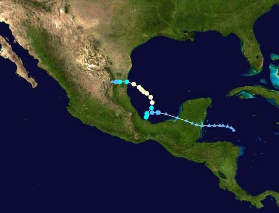
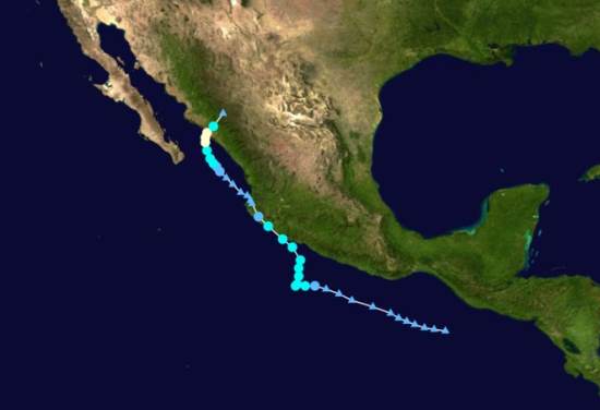
For the first time since 1958 Mexico was bashed virtually simultaneously by two very destructive storms: Ingrid in the east and Manuel in the west. Before discussing their destructive impact, we will describe the tracks of the two storms (photos below) and chart their chronology.

Track of Hurricane Ingrid

Track of Hurricane Ingrid

On September 10, weak weather disturbances were observed in the Caribbean east of the Yucatan Peninsula and in the Pacific south of Chiapas. The disturbance in the Caribbean gained some strength before hitting land which weakened it. It survived its crossing of the peninsula and re-emerged in warm waters of the southern Gulf of Mexico where it quickly gained strength. By the afternoon of September 12th it was upgraded to an official tropical depression.

Track of Hurricane Manuel

Track of Hurricane Manuel

Meanwhile the disturbance in Pacific moved slowly westward and by the morning of 13th was upgraded to a tropical depression. At about noon of the 13th both storms were upgraded to become named tropical storms (Ingrid and Manuel respectively) meaning they had winds of over 40 mph. In other words, the birth of “Ingrid” and “Manuel” were almost simultaneous (light green spots on the tracking maps). After earlier moving westward, both storms started to move north and slightly east picking up moisture, strength and wind speed over the warm ocean water.

Ingrid continued to move north gaining strength and by the next afternoon, the 14th, it was upgraded to a Category I hurricane with winds of 75mph. It started to move west and winds increased to 85mph on the morning of the 15th. Meanwhile Manuel also started to move west again skirting the coast of Guerrero and Michoacán. Early on the 15th Manuel’s winds reached 70mph. Though wind speeds did not quite reach hurricane level at that time and the eye of Manuel never made landfall, it brought enormous amounts of rain to coastal communities. For example, on September 14th Chilpancingo, Guerrero’s capital, got 393mm (15.5”) of rain while Acapulco got 140mm (5.5”) (Wunderground.com). This, added to considerable rain on preceding and following days, led to horrific flooding.

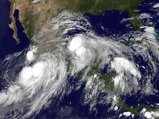
Satellite image of Hurricane Ingrid and Hurricane Manuel, September 2013

Satellite image of Hurricane Ingrid and Hurricane Manuel, 15 September 2013

On September 15th Hurricane Ingrid with winds of 75-85mph drifted toward Taumalipas in northeast Mexico. Meanwhile. Tropical Storm Manuel with winds about 60mph made landfall near Manzanillo, Colima. Once over land, the storm quickly lost power; by that evening winds were down to 35mph and Manuel was downgraded to tropical depression, but heavy rainfall continued. The next morning on the 16th Manuel’s winds were down to 30mph and it was further downgraded to a “remnant” of a tropical storm. But later that day, the remnant of Manuel move back to the Pacific Ocean near Puerto Vallarta and began to regain its strength.

That same morning September 16th Ingrid, which had weaken to a tropical storm with winds of 65mph made landfall just east of Ciudad Victoria, Tamaulipas. By the next morning, the 17th, Ingrid’s winds were down to 25mph and it was downgraded to a “remnant” though heavy rainfall continued.

Later on the 17th, Manuel regained its status as a tropical depression (winds of 35mph). The next morning, the 18th, it regained tropical storm status and by that afternoon it became Hurricane Manuel with winds of 75mph. Early on the 19th it made landfall west of Culiacan, Sinaloa. Moving east over land Manuel quickly lost power and was down to a remnant by the morning of the 20th. However, the remnant of Manuel continued far north and east joining the remnant of Ingrid and bringing torrential rains and flooding to central Texas, including Austin.

While storms are classified by their wind speeds from tropical depressions to tropical storms and then to hurricanes with intensities one up to five; this classification does not capture the extent of damage that can be caused. The amount of rain combined with the terrain can be far more damaging than the wind speeds. Furthermore the storm surge associated with a storm’s low pressure and high tides can be far more devastating than the winds as we saw with Hurricane Rita in New Orleans and Hurricane Sandy in New York.

In the case of Manuel, the amount of rainfall was far more destructive than the winds. The rains of Manuel as a “tropical storm” off the coast of Guerrero did far more damage than Hurricane Manuel did later in the State of Sinaloa or Ingrid did in eastern Mexico. Manual caused a total of about 84 reported deaths. At least 72 people were reported dead in Guerrero and another 68 were reported missing in the town of La Pintada that was partially buried under a massive mudslide. In Acapulco about 18 died. Floods closed the exit highways and the airport, temporarily stranding 40,000 tourists. These photos from the Guardian and USAToday show the extent of flooding in Guerrero, especially around Acapulco.

In contrast fewer than a dozen people reportedly died in Sinaloa which was later directly hit by Hurricane Manual. While Ingrid had considerably stronger winds than Manuel, its death toll of only about 23 was spread across several states from Puebla just east of Mexico City up to Tamualipas on the Texas border. More than half the total, 12 died in Altotonga, Veracruz, when a mudslide smashed into a bus. Of course, deaths are not the only, nor the best, measure of a storm’s destructive impact. Other commonly used measures are the financial cost of the damage and the number of people who evacuated or become homeless. No matter what measure is used, hurricanes are one of the most destructive natural hazards.

Related posts:

New Durango-Mazatlán highway officially open

 Other  Comments Off on New Durango-Mazatlán highway officially open
Oct 172013
 

President Enrique Peña Nieto has officially opened the new Durango-Mazatlán highway which has taken more than a decade to complete. He inaugurated the new highway early today (17 October), Mexico’s annual “Road Workers’ Day” (“Día del Caminero”).

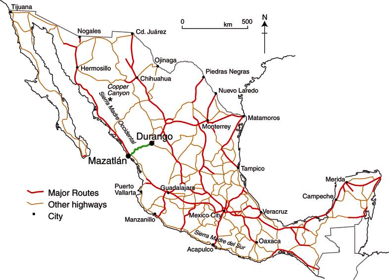
The new 1.2-billion-dollar, partly 4-lane, 230-kilometer highway will slash the time taken to drive from the city of Durango to the Pacific coast resort of Mazatlán, from 5 hours to about 3 hours. It is by far the single most important and complex road project in Mexico in recent years.

Mexico's major highways (Fig 17-3 of Geo-Mexico, the geography and dynamics of modern Mexico).

Mexico’s major highways (Fig 17-3 of Geo-Mexico, the geography and dynamics of modern Mexico). All rights reserved.

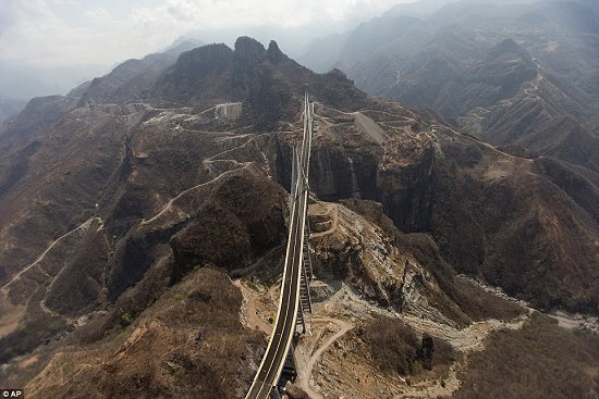
The most spectacular part of the highway is the Baluarte Bridge (Puente Baluarte), the tallest cable-stayed bridge in the world, which straddles the border between the states of Sinaloa and Durango and circumvents the need to negotiate the twisting and dangerous route taken by the old highway through the Espinazo del Diablo (Devil’s Spine). The Baluarte Bridge is a 1,124-meter-long bridge that rises almost 400 meters above the river below. The highway also includes 63 tunnels, the longest of which (El Sinaloense) is 2800 meters in length.

Durango-Mazatlan highwayThe firms involved in constructing the highway included Omega Corp, Tradeco Industrial, FCC Construcción, La Peninsular Compañía Constructora, Grupo Mexicano de Desarrollo and Grupo Hermes.

The highway has four toll booths; car drivers will pay about $500 pesos in total for a one-way trip along the entire length of the new highway. The highway is expected to carry 3,000 vehicles a day during its first year of operation, a figure expected to rise to 6,000 vehicles a day within the next six years.

Note: We are still waiting for a first-hand report from anyone who has driven the new highway. While the highway has been officially opened, at least one section of the highway is not yet open to regular traffic because of on-going repairs due to damage sustained during last month’s storms.

More photos?

Related posts:

The urban regeneration of Barrio Antiguo in Monterrey

 Updates to Geo-Mexico  Comments Off on The urban regeneration of Barrio Antiguo in Monterrey
Oct 142013
 

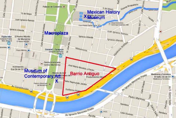
The city of Monterrey in Nuevo León has begun an urban regeneration scheme to rejuvenate one of its oldest sections, Barrio Antiguo (see map below).

Location of Barrio Antiguo, Monterrey.

Location of Barrio Antiguo, Monterrey. (Base: Google maps)

Barrio Antiguo is the area to the east of the Macroplaza. It is bounded to the south and east by Avenida Constitución, to the west by Calle Doctor Coss and to the north by Calle Padre Mier.

Earlier this year, city authorities, with assistance from the Nuevo León state government, published an online Catalog of Buildings of Historic and Artistic Importance in Barro Antiguo, which will form a basis for future planning decisions about any changes of land use in the area. [To view the entire catalog, scroll down in the center frame on that page.]

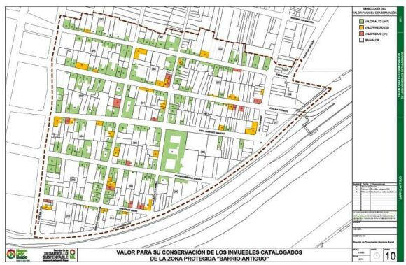
The Catalog includes a series of historic maps, from 1765, 1791, 1846, 1865, 1922, 1933 and 1947 respectively, as well as modern maps showing the location of all individual properties in Barrio Antiguo, color-coded to show their importance in terms of conservation and restoration efforts.

Conservation value of buildings in Barrio Antiguo, Monterrey

Conservation value of buildings in Barrio Antiguo, Monterrey (green=high, yellow=medium; red=low; white=no value)

The first phase of the urban regeneration scheme (called “Nuevo Barrio Antiguo”) includes a “paint job” in which all the buildings in the Barrio’s 16 blocks (manzanas) will be repainted in pastel colors. Owners can choose from a palette of pastel colors that has been predetermined as being in keeping with the historic and architectural characteristics of the area. Click here for the approved colors, complete with color swatches, and the matching paint names for different manufacturers.

During the first phase, new street signs will be installed, as well as tiles highlighting associations to famous people who lived or worked in the Barrio Antiguo. A second phase will restore sidewalks, add new street lighting, and involve public consultation about creating cultural and recreational space. Some streets would also be pedestrianized. Planners would seek to ensure that a wide mix of land uses is retained in the area, including residential, and that the area becomes attractive to visitors and tourists. The accessibility of Barrio Antiguo would be boosted if (or when) Line 3 of the city’s Metro system is built, since its proposed route would start near Barrio Antiguo and run 7.5 kilometers to the Metropolitan Hospital.

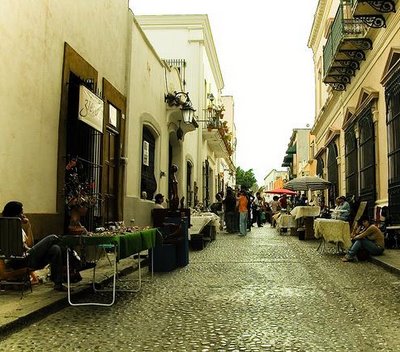
Barrio Antiguo, Monterrey

Barrio Antiguo, Monterrey

The Catalog identifies 193 buildings from the 18th, 19th and 20th centuries as being worth preserving, and the catalog entries for individual buildings provide a cross-reference to other listings of historic buildings such as those previously compiled by the National Anthropology and History Institute (INAH) and state-level agencies. The oldest building in Barrio Antiguo apparently dates back to 1765, while La Casa del Campesino incorporates parts of an even earlier building (from 1728). The listed buildings cover a range of architectural styles ranging from what is described as “vernacular north-eastern architecture” to neoclassic and art deco.

As Monterrey has grown, the condition of Barrio Antiguo’s building stock has deteriorated significantly. During the 1990s and 2000s, many buildings were turned into twilight zone businesses such as cafes, bars and nightclubs. La Casa del Campesino has been repeatedly re-purposed over the years, serving at different times as a government building, charity, hospital, and even a short-term emergency shelter following severe floods in 1909.

Not everyone is happy about the regeneration plans. Critics are vocal about the potential interruption to commerce and small businesses, and fear that it will attract land speculators.

In addition, this is not the first time that plans have been hatched to regenerate Barrio Antiguo. Grandiose plans have been announced on several previous occasions but have never come to fruition.

Housing policy in Monterrey

This 2008 paper by Dr. Peter Ward provides an excellent introduction to housing policy in Monterrey Metropolitan Area:

Related posts:

Plan for open-pit gold mine in Baja California Sur rejected

 Books and resources, Mexico's geography in the Press  Comments Off on Plan for open-pit gold mine in Baja California Sur rejected
Oct 122013
 

In November 2012, the federal Environment and Natural Resources Secretariat (Secretaría de Medio Ambiente y Recursos Naturales, Semarnat) refused a request to allow open-pit (opencast) mining in the buffer zone of the Sierra La Laguna Biosphere Reserve in Baja California Sur.

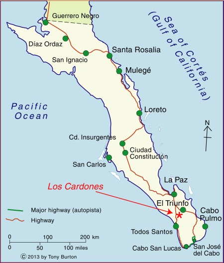
The request came from Zapal SA de CV, whose mining project, currently named “Los Cardones”, is located about 60 km from La Paz, the state capital. The proejct is close to the small settlements of El Triunfo, San Antonio and El Rosario. This mining project was previously called “Paredones Amarillos” and “La Concordia”. The original Concordia project, proposed by US mining firm Vista Gold and Toronto-listed Argonaut, was opposed on environmental and public health grounds by several environmental groups including the Mexican Center for Environmental Law (CEMDA).

Location of Los Cardones mining project. Credit: Tony Burton/Geo-Mexico

Location of Los Cardones mining project.

The latest version, Los Cardones, was resubmitted to authorities in September 2012. The project involved 423 hectares of semi-arid scrub-land, from which Zapal hoped to extract 40 metric tons of gold in the next decade using open-cast (pit) mining. The $217-million project would have created around 2200 jobs.

According to the project’s website (no longer functional), the mining project would have relied entirely on desalinated seawater (brought to the site by a 40-km aqueduct), which would be continuously recycled, and would therefore have no impact on local aquifers. Zapal claimed that the mine would have been the first gold mine in Mexico to use a closed-system cyanidation process, designed to prevent any contamination of the local environment. Zapal is part of the Invecture group which already operates an open cast copper mine in Piedras Verdes, Sonora, claimed to have an impeccable environmental and safety record.

Semarnat rejected the proposal on the grounds that it did not meet the legal requirements for mining operations in a Biosphere Reserve buffer zone. It is likely that a revised application will be made in due course. However, officials of the Baja California state government have previously gone on record as saying that they will oppose any open-cast mining in the state, because of its potential environmental impacts.

Anti-mining protests elsewhere in Mexico

David Bacon, author of “The Right to Stay Home: How US Policy Drives Mexican Migration”, wrote an informed account for the American Program website of several cases across Mexico where opposition to Canadian mining firms has arisen.

  • Mexican Farmers Up Against Canadian Mining Goliaths

A Guardian photo essay entitled “Mexico mining: ‘When injustice is law, resistance is duty’ – in pictures” reported on a January 2013 meeting of some 500 activists from across Mexico and Central America in Capulálpam de Méndez, Oaxaca. The meeting’s slogan was,  “Si la vida! No la
minera!” (Yes to life! No to mining!). It was held to co-ordinate local resistance to the human and environmental costs of mining on the region’s communities.

Related posts:

Why is northern Mexico a desert region?

 Excerpts from Geo-Mexico  Comments Off on Why is northern Mexico a desert region?
Oct 102013
 

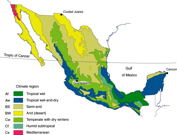
Much of northern Mexico experiences either an arid (desert) climate (less than 250 mm [10 in] of rain/year) or a semiarid (semi-desert) climate (250–750 mm [10–30 in] of rain/year). Areas with an arid (desert) climate (see map) include most of Baja California and western Sonora (together comprising the Sonoran desert), as well as the northern section of the Central Plateau (the Chihuahuan desert). These areas can experience frost and freezing during the winter.

Major climate regions in Mexico. (Fig 4-5 of Geo-Mexico, the geography and dynamics of modern Mexico). All rights reserved.

Major climate regions in Mexico. (Fig 4-5 of Geo-Mexico, the geography and dynamics of modern Mexico). All rights reserved.

Areas of semiarid (dry steppe) climate include most of the Central Plateau as well as western sections of the Western Sierra Madre, northern Yucatán and scattered inland areas as far south as Oaxaca. The rains in this region fall mostly in the summer, and localized heavy thunderstorms are quite common. The southern parts of this climatic region are warmer than the northern parts. (Mexico’s seven climate regions)

Why do parts of northern Mexico receive very little precipitation, making them deserts?

The major reason is that the zone between the Tropic of Cancer (latitude 23.5 degrees N) and latitude 30 degrees N is influenced by the Hadley Cell. This is the name given to the atmospheric circulation in tropical regions, named after George Hadley, the English amateur meteorologist who first proposed its existence, in 1735.

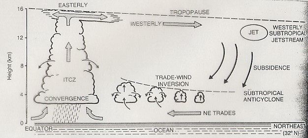
The Hadley Cell

The functioning of the Hadley Cell

The Hadley Cell is the driving force behind many aspects of Mexico’s weather and climate. How does it operate? Solar heating is at a maximum near the equator and diminishes towards the poles. The area near the equator is the Intertropical Convergence Zone or ITCZ (see diagram). The heating of the ITCZ makes the air there rise, leaving an area of low pressure on the surface. This low pressure sucks in air along the earth’s surface from the subtropical high pressure areas about 30 degrees N and S of the equator creating the trade winds. The trade winds pick up moisture and latent heat over the oceans before converging from either side of the equator in the ITCZ. As the air in the ITCZ rises vertically, its water vapor condenses and rain falls from the towering convective clouds. This is the ascending limb of the Hadley cell. At a height of 10–15 km above the surface, the air, now minus its moisture, returns polewards as high level anti-trade winds. Sunbathers on Mexican beaches who notice two sets of clouds above them at different heights traveling in opposite directions are witnessing the trade winds and anti-trade winds in action.

In the subtropics, this air then descends again towards the surface to complete the cell and initiates the surface trade winds again. The descending air warms up as it sinks; its relative humidity decreases, and so no precipitation occurs; hence these high pressure subtropical areas are arid. Mexico’s arid and semiarid areas coincide with the descending air segment of the Hadley Cell and these high pressure subtropical areas.

In addition, the climate of the west coast of the Baja California Peninsula is influenced by the cool Californian current, which flows towards the south. The relative humidity of the air above it drops as the current enters warmer waters, so it is not likely to bring rain to the peninsula.

The aridity of the Sonoran desert is also partly due to its position in the rain shadow of the Western Sierra Madre. The Chihuahuan desert is in an even more marked rain shadow, protected by both the Western Sierra Madre and the Eastern Sierra Madre.

Stunning stream patterns in northern Baja California

Photographer Adriana Franco from Querétaro has taken several truly stunning artistic images of stream patterns in the semi-arid region of northern Baja California (near Mexicali). The photos, taken from an ultralight, show the details of the dendritic (= tree-like) stream patterns in this region. Dendritic stream patterns are common worldwide, but these images are exceptional. In general, dendritic stream patterns are associated with relatively gentle gradients where the underlying rocks are similar throughout the drainage basin.

Related posts

Are Aztec chinampas a good model for food production and agro-development?

 Other  Comments Off on Are Aztec chinampas a good model for food production and agro-development?
Oct 072013
 

There is no doubt that Mexico’s indigenous farmers developed numerous ways to ensure successful harvests. The details varied from one region to another, but among the techniques employed were:

  • the mitigation of erosion by building earth banks and check dams in gullies
  • polyculture, recognizing that this minimized the risks inherent in monoculture.
  • the terracing of steep slopes to channel water where it was most needed.

In addition, some indigenous groups, including the Aztec in central Mexico, took advantage of their expertise in water management to develop highly productive systems of farming in wetlands. The chinampas (or so-called ‘floating gardens’) in the Valley of Mexico are the prime example of this water management skill, though similar systems were also used in the coastal marshes along the Gulf coast.

On the other hand, the later introduction of large-scale commercial farming methods has often led to deleterious impacts on the countryside and the long term sustainability of such methods is questionable.

In seeking to help Mexico’s rural areas, some development experts have suggested re-adopting Aztec methods, especially their method of building chinampas to farm wetlands. The invention of chinampas as a highly productive form of intensive wetland cultivation was, historically, one of the greatest ever agricultural advances in the Americas. Among other things, it allowed settlements to thrive in areas where rain (and therefore rain-fed food production) was markedly seasonal.

Among attempts to re-introduce ancient methods, one which stands out occurred in the 1970s and 1980s, when INIREB (Instituto Nacional de Investigaciones sobre Recursos Bióticos), based in Xalapa (Veracruz) employed chinamperos from the Valley of Mexico to build experimental chinampa-like fields in Veracruz and Tabasco . These projects are briefly described in Andrew Sluyter’s fascinating book Colonialism and Landscape, Postcolonial theory and applications (Rowman and Littlefield, 2002), the main basis for this summary.

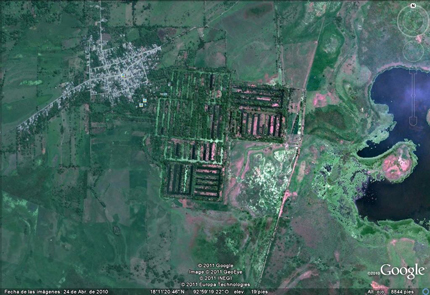
Google Earth image of camellones chontales

Google Earth image of camellones chontales

The most ambitious project was a later federally-organized one in Tabasco, where 65 massive platforms (camellones), each about 30 meters wide and from 100 to 300 meters long, were built in the swampy Chontalpa wetlands. The project, known as camellones chontales was backed by the local Chontal community though it was not directly involved in the construction phase. Because of the scale of the project, large mechanical dredgers were used to build the platforms, rather than relying on laborious and slower hand labor.

After construction, the Chontal community began farming the platforms, but initial results were very disappointing. Things improved with time, especially when the Chontal took full control of the project. From their perspective, the project meant that more members of the community now had land that could be farmed, and they shifted the emphasis away from the “vegetable market production” favored by officials towards growing corn (maize), beans and bananas for local household consumption, improving local food availability.

Recent press reports, such as this 2-minute Youtube clip (Spanish), claim that many parts of the camellones chantales have now been abandoned, owing to insufficient investment in maintenance.

Why did the project fail initially?

This is one of the key questions connected to this example. Sluyter refers to two articles written by Mac Chapin (from Cultural Survival, an organization that champions the rights of native peoples). Chapin argues that the projects, and their assumptions, were fundamentally flawed. For example, the use of dredges to construct the platforms turned the soil profile upside down, bringing infertile clay towards the top and sending nutrient-rich layers downwards, beneath the reach of plant roots. In turn, this meant that organic matter and fertilizers had to be added to the land in order for good crop yields. Because of the dredging, the canal floor between the platforms was very irregular, making it much more difficult for the Chontal to fish using drag nets. Many of the crops planted were “exotic” and production was market-oriented rather than subsistence or locally-oriented. Chapin was particularly critical of the lack of suitable transport routes for sending produce to distant markets. In addition, chemicals were needed because of the proliferation of insects in these lowland wetlands. (Insects are rarely a problem at the higher altitudes of central Mexico).

Chapin concluded that this development project was just one more in a long line of failures where an outside model was introduced into a new area without sufficient prior research or local involvement in the planning stages. Sluyter agrees with this conclusion, pointing out that there is no evidence that these Tabasco wetlands ever had any form of chinampa farming, even in pre-Columbian times, perhaps because they have “a much greater annual fluctuation in water level than those in Campeche and Veracruz”.

Want to read more?

Related posts:

“Los que llegaron”, Spanish language videos about Mexico’s immigrant groups

 Books and resources, Teaching ideas  Comments Off on “Los que llegaron”, Spanish language videos about Mexico’s immigrant groups
Oct 052013
 

Once TV México (“Eleven TV Mexico”) is an educational TV network owned by the National Polytechnic Institute (Instituto Politecnico Nacional) in Mexico City. Over the years, Once TV México programs have won numerous national and international awards.

Many of its programs are available as webcasts or on Youtube. Once TV México has made hundreds of programs that provide valuable resources for Spanish-language geography classes or for students of Spanish or anyone wanting to improve their Spanish-language skills. For example, their long-running program “Aquí nos tocó vivir” (“Here We Live”) has explored all manner of places throughout Mexico over the past 35 years, and has received UNESCO recognition for its excellence.

Of particular interest to us is “Los que llegaron” (“Those Who Arrived”), a series of programs looking at different immigrant groups in Mexico. Each 20-25 minute program focuses on a different group and explores the history of their migration to Mexico, their adaptation to Mexican life, their integration into society, the areas where they chose to settle, and the links between their home countries and Mexico.

Mexico has a long history of welcoming people from other countries, including political refugees. Each of these programs offers some fascinating insights into the challenges faced by migrants arriving in Mexico for the first time.

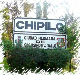
Sister city of Segusino, Italy

Sister city of Segusino, Italy

For instance, the program about Italian immigration to Mexico (above), explains why Mexico was seeking colonizers in the middle of the 19th century in order to populate and develop rural areas. One group of Italians settled in Veracruz (in present-day Gutiérrez Zamora); another group, 3,000 strong, and from the Veneto region in northern Italy, settled in Chipilo, near the city of Puebla. (For anyone not familiar with Chipilo, one of our favorite bloggers, Daniel Hernandez, has penned this short but memorable description of a typical Sunday morning there: Cruising in Chipilo, an Italian village in Mexico).

Italian immigration increased dramatically after the 1914-1918 war. Today, according to the program, there are approximately 13,000 Italian citizens residing in Mexico and an estimated 85,000 Mexicans of Italian descent. Note, though, that most sources quote a much higher figure for the latter category, perhaps as high as 450,000.

[Aside: In chapter 4 of “Mexican National Identity, Memory, Innuendo and Popular Culture”, William H. Beezley looks at the role of itinerant puppet theater in molding Mexico’s national identity. The largest and most famous single troupe of all was the Rosete Aranda troupe, formed by two Italian immigrants in 1850. The troupes went from strength to strength in the next half-century. By 1880, the Rosete Aranda company had 1,300 marionettes and by 1900 a staggering 5,104. Their annual tours around the country helped influence national opinions and attitudes.]

Program list for the “Los que llegaron” series:

  • Españoles (Spaniards)
  • Alemanes (Germans)
  • Húngaros (Hungarians)
  • Italianos (Italians)
  • Argentinos (Argentines)
  • Ingleses (English)
  • Japoneses (Japanese)
  • Estadounidenses (Americans)
  • Coreanos (Koreans)
  • Franceses (French)
  • Chinos (Chinese)
  • Libaneses (Lebanese)
  • Rusos y Ucranianos (Russians and Ukrainians)

Related posts:

Geotourism in Mexico: García Caves (Grutas de García) in Nuevo León

 Other  Comments Off on Geotourism in Mexico: García Caves (Grutas de García) in Nuevo León
Oct 032013
 

The Garcia Caves (Grutas de García) are located in the Cumbres de Monterrey National Park, 9 km from the small town of Villa de García, and about 30 km from the city of Monterrey (state capital of Nuevo León). The highest point in the park is Copete de las Águilas which rises to 2260 m (7,410 ft) above sea level, but its best known peak is Saddle Hill (Cerro de la Silla), the distinctive saddle-shaped hill that overlooks the city.

Much of the park, including the mountains, are composed of sedimentary rocks that were originally laid down as marine sediments and then subsequently folded, uplifted and exposed to erosion. The extensive areas of limestone in the park, which date from the Cretaceous period, have been subject to karstification over 50 to 60 million years, which has resulted in typical karst landforms such as sinkholes, caves, cave formations and underground streams.

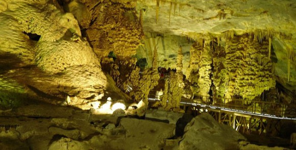
The Garcia Caves, one of the largest cave systems in Mexico, are deep inside the imposing Cerro del Fraile, a mountain whose summit rises to an elevation of 1080 meters above sea level, more than 700 meters above the main access road. The entrance to the caves is usually accessed via a short ride on a 625-meter cable car that was built to replace a funicular railway.

The cave system was first reported in 1843 by the Marmolejo family who informed their local prist Juan Antonio Sobrevilla that they had stumbled across it while looking for firewood.

Grutas de García. Credit: María de Lourdes Alonso

Grutas de García. Credit: María de Lourdes Alonso

Guided tours of the cave system show visitors some of its 27 separate chambers along a 2.5-kilometer (1.6 mile) route. The full system extends more than a kilometer further into the mountain reaching depths of more than 100 meters (340 feet) beneath the surface. The limestone of the cave walls contains lots of marine fossils. The caves have extensive and impressive formations of dripstone, including stalactities, stalagmites and other forms.

Unlike the suffocating heat of the Naica Crystal Caves in Chihuahua, the cave temperature here remains about 18̊C (65̊F) all year.

The chambers and formations have been given whimsical and imaginative names such as

  • “El salón de la luz” (The Light Chamber) where the natural translucence of the ceiling rock allows light from the outside to filter through.
  • “La octava maravilla” (The Eighth Wonder), a natural column formed where a stalagmite growing from the floor joined a stalactite, growing from the ceiling
  • “El mirador de la mano”, a stalagmite shaped like a human hand.
  • “El Nacimiento” (The Nativity),
  • “La Fuente Congelada” (The Frozen Fountain),
  • “La Torre China” (The Chinese Tower),
  • “El teatro” (The Theatre), and
  • “El Árbol de Navidad” (The Christmas Tree).

Want to read more about caves in Mexico?

Visit John Pint’s website for a selection of his writing, with many original articles, illustrated with great photographs, about many individual caves in Mexico.

Related posts