Rocks and relief fieldtrip: Tequisquiapan and the Peña de Bernal

 Other, Teaching ideas  Comments Off on Rocks and relief fieldtrip: Tequisquiapan and the Peña de Bernal
Jun 212012
 

There is a close connection between geology and relief in many parts of Mexico. In this post we describe a one-day fieldwork excursion in the Tequisquiapan area of the central state of Querétaro that looks at this connection. The fieldwork is suitable for high school students but could easily be extended to provide challenges for college/university students.

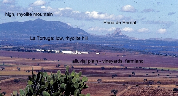
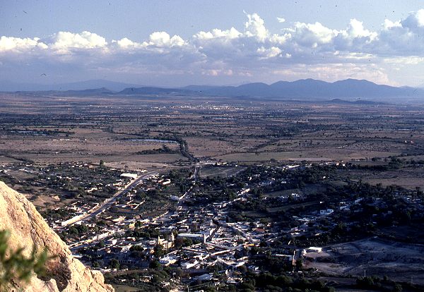
The fieldwork starts with a fieldsketch from near Tequisquiapan. Any suitable vantage point will do, provided it offers a clear view northwards to the very distinctive Peña de Bernal (seen in the background of the photo below). At this point, a simple line sketch should suffice to help students identify the following four different kinds of terrain:

  • flat or gently sloping plain, used for cultivation
  • low hills, with gently sloping sides, which look to be covered in bushes and cacti [scrub vegetation]
  • high mountains, with steeper slopes, also with no obvious signs of cultivation
  • the Peña de Bernal itself, a distinctive monolith with exceptionally steep sides

There is no need to identify any rocks or use any geological terms (students can add appropriate labels later!). Engage the students in a discussion about why there might be four different kinds of relief visible in this area, and how their ideas or hypotheses could be investigated further. Conclude the discussion by explaining that they are now going to look for evidence related to the idea that these four different kinds of relief are connected to significant differences in geology.

View looking north from "Las Cruces" near Tequisquiapan. Photo: Tony Burton; all rights reserved.

View looking north from "Las Cruces" near Tequisquiapan. Photo: Tony Burton; all rights reserved.

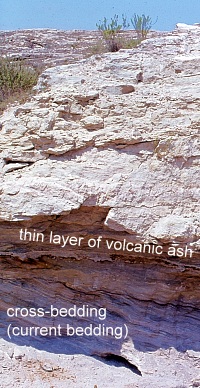
The next stop is a small roadside quarry on the flat area. The most accessible quarry many years ago was located a short distance south of Tequisquiapan on the east side of the highway, but any quarry on the flat land will serve to reveal the rocks that form the plain.

Roadside quarry, near Tequisquiapan. Photo: Tony Burton; all rights reserved

Roadside quarry, near Tequisquiapan. Photo: Tony Burton; all rights reserved

[Warning: Ensure that you park off the highway; when examining the rock in the quarry, avoid any overhanging sections, and do not do anything to cause slope instability or collapse].

The rocks in the quarry are in layers (sedimentary) and very distinctive. The individual particles of the rock are rough to the touch and sand-sized, so this is some kind of sandstone.

Some layers are more or less horizontal, but in places successive layers are laid down at a much steeper angle. This is “current bedding” and indicates that the rocks were formed by water, perhaps where a river entered a lake. The individual particles in the rock are not well-rounded, so have not traveled all that far.

Within each major layer, the material shows signs of sorting, with fine material sitting on top of coarse material. In some places, the sandstone contains small pebbles, so this rock is a sandstone conglomerate. Small casts of fossil shells can be seen in places, further suggesting it is a sedimentary rock deposited in a former lake.

A very thin white layer is present (at about head height in the photo). This layer is totally different to the sandstone conglomerate. It is fine material that has been compacted. Given the volcanic history of central Mexico, this is almost certainly a thin layer of volcanic ash that covered older rocks before being covered in turn by the next layer of sediments.

With some guidance, students should be able to work most of this out for themselves! The last stage at this stop is to ask why this rock forms the flat land in the area, rather than the hills. (Answer: softer, weaker, less resistant, easier to erode, etc).

The next stop is to take a look at the rock forming the low hills. The highway between Tequisquiapan and Ezequiel Montes (see map) conveniently cuts through a low ridge at San Agustín. This affords an opportunity to take a close look at the rock forming that ridge. [Warning: Ensure that you find a safe parking spot, and take every precaution, since traffic along this highway can be heavy and very fast-moving]

The rock at San Agustín is darker and much harder than the rock in the quarry. It has clear crystals in it, apparently arranged haphazardly. From its color (grey) and grainsize (fine), it is a rhyolite [a fine grained, acid igneous rock].  It is far more difficult to erode than the sandstone on the plain, so it forms upstanding ridges and low hills in the landscape.

From San Agustín, drive through Ezequiel Montes and on to the town of Bernal, one of Mexico’s “Magic Towns“. The next part is the most physically-challenging part of the excursion since it is necessary to climb at least part-way up the Peña de Bernal! [Warning: this is very steep in places, and climbing beyond the mid-way “chapel” is definitely not recommended]. Examining the rocks of the Peña de Bernal reveals that they are lighter in color than the rhyolite and fine-grained, but with larger crystals (phenocrysts) in some places. This rock must have cooled very slowly (or the phenocrysts would not have had chance to form) and this is an intrusive igneous rock known as microgranite. Eagle-eyed students should also find some other rocks while climbing the Peña de Bernal. In places, it is possible to find good specimens of a very hard, banded metamorphic rock that was formed when heat and/or pressure transformed pre-existing rocks. The banded rock is a gneiss [pronounced “nice”].

The presence of intrusive igneous rocks (formed underground) together with metamorphic rocks strongly suggest that the Peña de Bernal is an example of a volcanic plug. It represents the central part (and all that now remains) of a former volcano, whose sides, presumably composed of ashes and lava, have long since eroded away.

Conclusion:

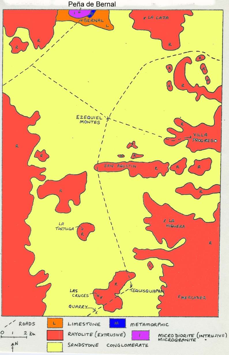
After students have had chance to work most of this out for themselves, a look at the local geological map should confirm that their deductions are reasonable. As can be seen on the map below, the flat area is indeed an alluvial plain (sandstone), with low rhyolite hills and ridges in places, and higher rhyolite mountains in the background, with the distinctive Peña de Bernal made of igneous and metamorphic rocks at the northern edge of the map.

In this particular part of Mexico, as in many other areas, the link between geology and relief is very strong! Happy exploring!

Sketch map, Geology of the Tequisquiapan area

Sketch map, Geology of the Tequisquiapan area; click to enlarge

Related posts:

The geography of Tequisquiapan, a spa town in the state of Querétaro

 Other  Comments Off on The geography of Tequisquiapan, a spa town in the state of Querétaro
Jun 142012
 

The town of Tequisquiapan is an excellent place for geographers!

For one thing, it has a monument claiming to be The geographic center of Mexico. While this is hotly disputed, it is a fun place to start!

Tequisquiapan is an attractive spa town which has many hotels, restaurants and stores. It has grown substantially in recent years, attracting former Mexico City dwellers tired of the traffic congestion, smog and challenges of living in the big city. Mid-week, Tequisquiapan is largely deserted, with the air of a ghost town, waiting for revival. Revival occurs every weekend as the wealthier residents of Mexico City flee the city in search of clean air and blue skies. The town’s restaurants begin to fill and the discos gear up for action lasting into the early hours. Many of the weekenders now own second homes in Tequisquiapan.

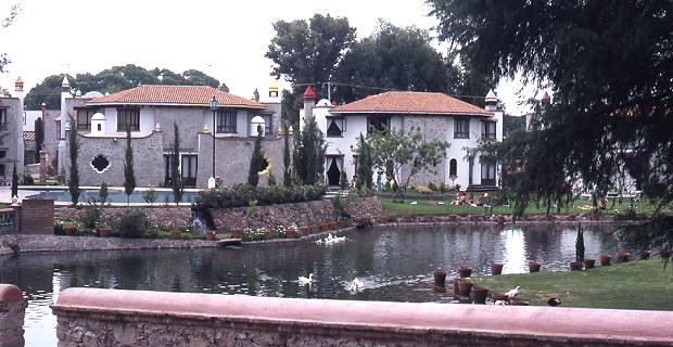
Upmarket homes in Tequisquiapan. Photo: Tony Burton; all rights reserved

Upmarket homes in Tequisquiapan

Why is Tequisquiapan such an attractive choice for them? The key attractions (see Tequisquiapan, Querétaro: a delightful spa town)  are:

  • a small town atmosphere, with winding cobblestone streets, lined by attractive and neatly kept one-story buildings
  • the town boasts a dozen or more “three star” or better hotels, all with thermal swimming pools, and a multitude of handicraft shops and galleries
  • an 18-hole golf course, open to the public
  • a specialist handicrafts market, a lively permanent market and, on weekends, numerous small street stalls selling precious stones and jewelry (for enticing pictures, see Tequisquiapan, provincial Mexican charm  on MexConnect.com)
  • the town is small enough to walk around and bathed in sunshine virtually all year round
  • an annual cheese and wine festival in early summer
  • it is less than two hours by car from Mexico City
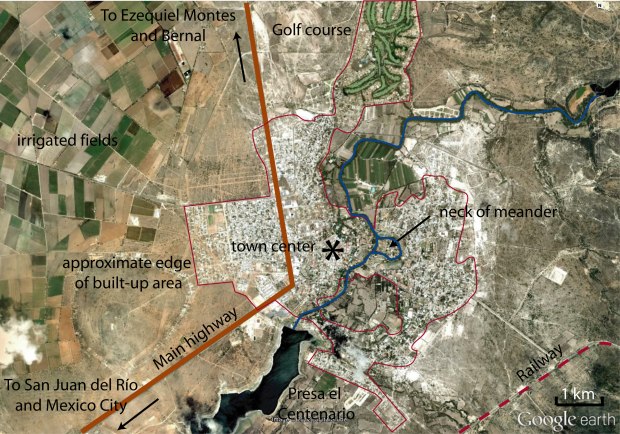
Annotated Google Earth image of Tequisquiapan area

Annotated Google Earth image of Tequisquiapan area

Anyone interested in urban geography will find that Tequisquiapan’s layout is quite unusual (for Mexico).  Some streets in the center of the town wander aimlessly rather than conforming to the traditional Mexican grid pattern. By way of comparison, a newer area of settlement across the highway (see image above) exhibits perfect grid pattern.

Bougainvillea-covered wall in Tequisquiapan

Behind the stone walls of the many fine hotels, the spa waters of Tequisquiapan offer their temptation. Why hike the streets when you can laze by a pool? The water is tepid rather than hot but very welcome, given the arid heat that envelops this area most of the year.

Towards the south-east, the town has grown around existing farmland, so homes surround an undeveloped core of agricultural land.

To the north, a former hacienda (Hacienda Grande) has been converted into a residential area built around a golf course. The irrigated fairways are strikingly visible on Google Earth.

Tequisquiapan is one of the few Mexican towns of its size and age to have a gated community in the downtown core, immediately off the main plaza.

Physical geographers won’t be disappointed either. Also near the center, upmarket houses have been built on the neck of a cut-off meander which has left an “island” with the river on either side. Floods on this river are now unlikely since it is controlled by the Centenario dam which has created a reservoir, Presa el Centenario, used for water sports.

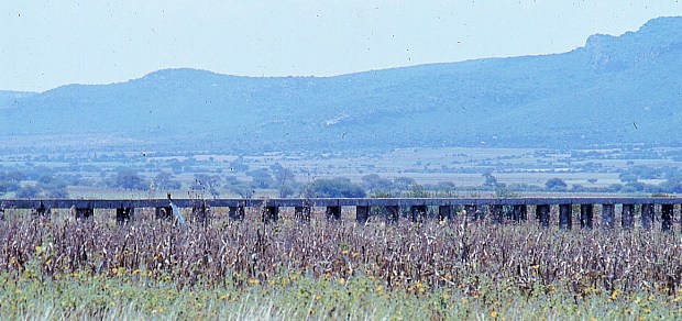
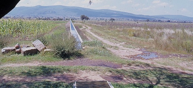
The flat valley floor around Tequisquiapan has become a rich farming area, particularly well known for its vineyards. A network of aqueducts and irrigation channels helps farmers overcome the vagaries of the annual dry season.


Aqueduct near Tequisquiapan. Photo: Tony Burton; all rights reserved.

Aqueduct near Tequisquiapan

The fact that this area has a pronounced dry season means that most local streams are intermittent; they run only for short periods during and immediately after the rainy season. The rest of the year, their channels are dry, providing a perfect opportunity for physical geographers to walk along them studying their features and landforms, without even getting their feet wet!

Irrigation channel near Tequisquiapan. Photo: Tony Burton; all rights reserved.

Irrigation channel near Tequisquiapan

On balance, given all these points of geographical interest, maybe Tequisquiapan is right to call itself the “geographic center” of Mexico after all!

Photos:

All photos in this post are by Tony Burton; all rights reserved.

Jun 072012
 

The Peña de Bernal, in the central state of Querétaro, is one of Mexico’s most distinctive geomorphosites. Geomorphosites are “landforms that have acquired a scientific, cultural/historical, aesthetic and/or social/economic value due to human perception or exploitation” (Panizza M., 2001). See Geotourism and geomorphosites in Mexico for a brief introduction to the topic.

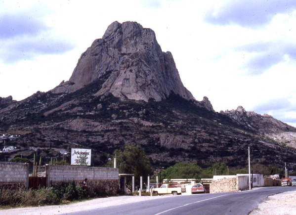
The Peña de Bernal is a dramatic sight, which only gets more imposing the closer you get. How high is the Peña de Bernal? We are unable to give you a definitive answer (it depends where you start measuring from) but claims of 350 meters (1150 feet) sound about right, assuming we start from the town.

Peña de Bernal. Photo: Tony Burton; all rights reserved

The Peña de Bernal. Photo: Tony Burton; all rights reserved.

According to its Wikipedia entry, this is the “third tallest monolith in the world”, apparently only exceeded by the Rock of Gibralter and Sugarloaf Mountain in Rio de Janeiro. Others, including Melville King, have described it as the “third largest rock in the world”. These claims may (or may not) be exaggerated, but in reality it is definitely a very steep and tiring climb, even to reach the small chapel that has been built half-way up! The photo below is taken from this chapel, looking out over Bernal and the local farmland and vineyards.

View from the Peña Bernal, with the town of Bernal in the foreground.

View from the Peña de Bernal over the small town of Bernal. Photo: Tony Burton; all rights reserved.

How was the Peña de Bernal formed?

The most likely explanation is that this monolith represents the hardened magma (molten rock) from the central vent of a former volcano. This rock was much more resistant to erosion that the layers of ash and/or lava that formed the volcano’s flanks. Centuries of erosion removed the sides, leaving the resistant core of the volcano exposed as a volcanic neck. We will examine this idea in slightly more detail in a future post.

The town of Bernal

The town of San Sebastián Bernal is also well worth visiting. Having become a magnet for New Age types, it now boasts several decent restaurants, good stores and a range of hotels including high quality “boutique” hotels. Bernal was designated one of Mexico’s “Magic Towns” in 2005. To learn more about the town of Bernal and see some fine photos, we highly recommend Jane Ammeson’s article “The magic of Bernal, Querétaro: wine, opals and historic charm.

At the Spring Equinox (March 21), the town is invaded by visitors “dressed in long, white robes or gowns, and red neckerchiefs” who come seeking “wisdom, unity, energy and new beginnings”. (Loretta Scott Miller writing in El Ojo del Lago, July 1997).

How to get there:

From Mexico City, take the Querétaro highway (Hwy 57D) north-west to San Juan del Río. Then take Highway 120 past Tequisquiapan as far as the small cross-roads town of Ezequiel Montes. Turn left for about 11 kilometers, then right… and you’re there! Taking this route gives you glimpses of the Peña de Bernal from afar. Allow 2.0 to 2.5 hours for the drive.

Other geomorphosites worth visiting:

Mexico has literally thousands of geomorphosites. Among those described in previous posts are:


Transit of Venus will be visible from Mexico, 5 June 2012

 Other  Comments Off on Transit of Venus will be visible from Mexico, 5 June 2012
May 312012
 

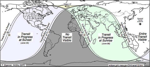
Next week, clear skies permitting, a Transit of Venus will be visible from all of Mexico (as well as the USA, most of Canada, etc). During a transit of Venus, the planet Venus passes slowly in front of the sun from the perspective of a viewer on Earth.

CAUTION: Never observe the sun directly, even during a transit of Venus, or your eyesight may be permanently damaged. Transit viewers should take similar precautions to those needed to observe an eclipse.

Such events are rare. This will likely be the last chance to see one in your lifetime since the next transit of Venus will be in more than 100 years time!

Map showing areas where transit of Venus is visible

Map showing areas where transit of Venus is visible [Credit: NASA

Back in the eighteenth century, scientists from France anxious to observe the 1769 transit of Venus were forced to seek permission from Spain to join a party of Spanish astronomers setting up a temporary observatory in a Spanish colony which was predicted to offer the best views. These astronomers congregated at a site very near the present-day settlement of San José del Cabo on the southern tip of the Baja California peninsula. A short distance away, a creole astronomer Joaquín Velázquez de León, who had traveled from Mexico City, set up camp to make his own independent observations. Scientific trips at this time were not without their perils; only days after the transit, three members of the Franco-Spanish party, including the two principal astronomers, died after contracting yellow fever.

The next transit of Venus occurred in the year 1874. Mexico has a particular connection to this transit. To observe this event, and take scientific measurements, Mexico’s first ever international scientific expedition was undertaken. A distinguished group of Mexican scientists traveled to Japan to study this event. By the time they returned, they had been all the way around the world.

Mexico has a long history of astronomy. Several indigenous groups, including the Zapotecs in Oaxaca and the Maya in the Yucatán Peninsula undertook sophisticated astronomical observations, enabling the successful prediction, not only of annual events such as the summer solstice, but also of longer-term phenomena such as eclipses. Mexico (admittedly not called that at the time!) hosted one of the earliest international astronomical conferences in the world.

According to some, the Maya predicted that the world will come to an end on 21 December next year. The claims are based on the fact that the current Maya calendar cycle “ends” on that day. The Maya have several simultaneous calendar counts. Each long cycle count, or B’ak’tun, lasts 394.3 years. The very first B’ak’tun began on 11 August 3114 BC, the date when the Maya believe they were created. The 13th B’ak’tun ends on 21 December 2012, hence the concern propagated by panic-mongers.

The Maya themselves don’t seem too worried by these alarmist claims. They worked out years ago that their 14th B’ak’tun cycle will start the next day, 22 December 2012, and run to sometime in 2406. On the other hand, is it just a simple coincidence that on 21 December 2012, at the exact moment of the winter solstice at 23:11 UST, the sun will be precisely aligned with the center of the Milky Way galaxy, as seen from Earth— the first time this has happened for 26,000 years?

Will the claims be proven true? Unlikely, but perhaps we won’t plan to write any posts about the geography of Mexico for publication after 22 December 2012 until we’re absolutely sure…

Need more evidence about the Maya prediction? As a starting-point, try:

How does Mexico’s electoral process compare to other countries?

 Other  Comments Off on How does Mexico’s electoral process compare to other countries?
May 232012
 

On 1 July 2012 Mexicans go to the polls to elect a new six year president, a new senate and chamber of deputies. At the same time, voters in some states–Jalisco, Nuevo León, Guanajuato, Querétaro, Sonora, San Luis Potosí, Morelos, Federal District, Campeche and Colima– will cast their ballots in elections for state and local officials.

How free and fair are Mexican elections compared to those in other countries?

Before addressing this question, it is useful to acknowledge that elections in Mexico have improved dramatically in the past two decades, largely as a result of progressive reforms including the establishment of a strong and independent National Elections Commission (Instituto Federal Electoral, IFE). Prior to the late 1990’s one party, PRI (Partido Revolucionario Insititucional, Institutional Revolutionary Party) dominated most elections at the national, state and local level. Starting in 2000, when an opposition party, PAN (PAN or Partido Acción Nacional, National Action Party), won the presidency, elections in Mexico have been quite competitive. In 2006 a third party, PRD (Partido de la Revolución Democrática, Party of the Democratic Revolution), lost the presidency to PAN by less than 0.6% (35.89% to 35.31%). Since 1994 the winner of the presidency has not garnered 50% of the votes, leading some to argue that Mexico should conduct runoffs between the two highest vote-getters.

CountryScoreCountryScoreCountryScore
Uruguay10.00Peru9.17Turkey7.92
Canada9.58MEXICO8.75Indonesia6.92
Chile9.58Argentina8.75Venezuela5.67
India9.58Israel8.75Nigeria5.67
Brazil9.58South Africa8.75Russia3.92
USA9.17Guatemala7.92China0.00
Colombia9.17

The Economist Intelligence Unit (EIU) annually develops a “democracy index” which includes a factor titled “electoral process and pluralism”. Scores on this factor are based on 12 questions concerning the conduct of free, fair and transparent elections open to all groups and all voters as well as the orderly transfer of power to those winning elections. Based on the EIU scores for 2011, countries with the perfect score of ten were Uruguay, Norway, Iceland, Denmark, Finland, Luxembourg, Australia and New Zealand. Mexico is tied with Argentina, Israel and South Africa, trails Chile, Brazil, Colombia and Peru but is much closer to the top than the bottom (see table). Mexico is a point and a quarter below a perfect ten and almost a point ahead of Guatemala, three ahead of Venezuela and almost five ahead of Russia. China is last with a score of zero along with Saudi Arabia, Ethiopia, North Korea, and other authoritarian regimes.

It will be interesting to see how the EIU scores Mexico after the 2012 elections.

 Related posts:


How does democracy in Mexico compare to other countries?

 Other  Comments Off on How does democracy in Mexico compare to other countries?
May 192012
 

This is a very important year for Mexico’s democracy. On 1 July 2012 Mexicans will go to the polls to elect a new president, who will hold office for six years, a new Senate and new Chamber of Deputies as well as numerous state and local officials. How does Mexico’s democracy compare with that of other countries?

“Democracy” is a slippery concept; it is not at all easy to define and is very difficult to measure. In the abstract “democracy” is a form of government in which ultimate power is vested in the people or their freely elected representatives. In common usage, democracy implies active civil participation in free and fair elections, effective and efficient governance, basic human and minority rights as well as freedom of religion, expression and organization. Obviously these concepts are not easily measured.

The most widely used measures for international comparisons are provided by Freedom House which relies on experts to rate countries on “Political Rights” and “Civil Liberties” (Freedom in the World 2012). Assessing “political rights” is based on free and fair elections, effective political pluralism and participation as well as government properly functioning in the interest of the electorate. Measuring “civil liberties” investigates freedom of speech, press, assembly and religion, a fair and just legal system, personal autonomy and individual rights, as well as active participation of nongovernmental and labor organizations. The Freedom House process results in measures from one (the highest) to seven (the lowest).

The Economist Intelligence Unit (EIU) has also developed a “Democracy Index” based on experts’ ratings and public opinion surveys on five components – electoral process and pluralism, civil liberties, the functioning of government, political participation and political culture. The EIU process gives each county a score from a high of ten to a low of one  on overall democracy as well as the five components.

CountryFreedom House
Political Rights
1 - 7
Freedom House
Civil Liberties
1 - 7
Economist Index
Democracy Index
10 - 1
Canada119.08
USA118.11
Chile117.54
South Africa227.79
Brazil227.12
Argentina226.84
India237.30
Indonesia236.53
MEXICO336.93
Colombia346.63
Guatemala345.88
Venezuela555.08
Russia653.92
China763.14

Mexican democracy is somewhere in the middle when compared to other countries. The table compares democracy in Mexico with that in selected other countries based on the measures used by Freedom House and the EIU. Mexico was designated as a “flawed democracy” [see note 1] by the EIU in 2011, along with 52 other countries including France, Chile, Brazil, Argentina, Indonesia and Ghana. Mexico’s score of 6.93 out of ten ranked it 50th of 167 countries, one ahead of Argentina and a few places behind Brazil. It has made some relative progress since 2008 when it ranked 55th of 167.

In 2012 Freedom House placed Mexico in the highest level of the “partly free” category. In 2010 Mexico was at the bottom of the “free” category; it dropped out of this category because its “political rights” score went 2 to 3, with 1 being the highest. Mexico had maintained a score of 2 from 2000 to 2010, but went to 3 in 2011. Apparently the experts must have noticed deterioration in the electoral process, political pluralism and participation or the functioning of government. The downgrading was probably related in some way to Mexico’s Drug Wars.

In 2010 Freedom House placed Mexico among 35 “Countries at the Crossroads” that are on the way to becoming consolidated democracies, but still have several challenges to overcome. Among these are the legacy of authoritarian rule, a culture which tolerates corruption and impunity, the persistence of private and public monopolies, lack of political accountability and transparency, and perhaps most importantly the growing influence and violence of drug cartels. These all skew the political playing field and undercut democratic progress, the political morale of the electorate, and openness of the media. On the positive side, active participation in recent elections has led to peaceful transitions of power. Civil society is gaining strength. New institutions such as the Federal Electoral Institute and the Federal Institute for Access to Information are making a difference. Significant improvements to the overall political situation will require concentrated efforts over an extended period of time.

It is interesting that according to Freedom House democracy in Mexico has deteriorated since 2008, while the Economist (EIU) perceived an improvement. This difference indicates how difficult and subjective assessments of democracy can be. For example in the table below “partly free” Mexico scores higher on the EIU’s democracy index than either Argentina and Indonesia which are classified as “free” by Freedom House.

Given the very important election being held in Mexico this year, a future post will investigate how Mexico’s electoral processes compare with those in other countries.

Note:

[1] “Flawed democracies”:  “These countries … have free and fair elections and even if there are problems (such as infringements on media freedom), basic civil liberties will be respected. However, there are significant weaknesses in other aspects of democracy, including problems in governance, an underdeveloped political culture and low levels of political participation.” Economist Intelligence Unit, “Democracy index 2011: Democracy under stress”, p 31. Democracy Index 2011.

 Related posts:


How serious is corruption in Mexico?

 Other  Comments Off on How serious is corruption in Mexico?
May 122012
 

Recent allegations of bribery related to Wal-Mart de México beg two questions:

  • How serious is corruption in Mexico?
  • How does corruption in Mexico compare to that of other countries?

Fortunately for us, these questions have been comprehensively investigated by Transparency International (TI), a global civil society organization dedicated to reducing corruption. TI defines corruption as “abuse of entrusted power for private gain”.

Its recent study, “Corruption Perceptions Index 2011” focuses on “perceptions” because corruption is a hidden activity that is difficult to measure. The Corruption Perceptions Index (CPI) draws on a wide array of surveys and polls of international experts, business opinion surveys and country residents. It is based on 17 data sources from 13 different institutions. The focus is on bribery, kickbacks and embezzlement involving politicians, public officials and civil servants. Anti-corruption efforts are also considered.

Given the difficulties associated with measuring and interpreting corruption, the CPI has received considerable criticism. (For example, see this Wikipedia entry on  Corruption Perceptions Index). Despite this criticism, the CPI provides a viable approach to comparing corruption in various countries.

According to this index, perceived corruption in Mexico has become considerably worse in the past few years. In terms of freedom from corruption, Mexico’s 2011 score of 3.0 ranks it below the middle, in rank #100 out of 182 countries, tied with 11 other countries including Argentina and Indonesia. It is interesting to note that some individual Asian, African, European and Latin American countries are considerably ahead of Mexico (see table), but others are considerably behind.

CountryRankCountryRankCountryRank
New Zealand1South Africa64Argentina100=
Canada10Italy69=Indonesia100=
UK16Ghana69=Egypt112
Chile22Brazil73Guatemala120
USA24China75Nigeria143=
South Korea43Colombia80Russia143=
Saudi Arabia57India95Venezuela172
Turkey61MEXICO100=Somalia182

Within Latin America, Mexico is far better than Venezuela, Haiti and Paraguay. However, it is way behind Chile, Uruguay, Costa Rica and Brazil. As a regional leader, Mexico should do much better in terms of corruption.

Back in 2008, Mexico’s score of 3.6 placed it significantly above the middle. It was then ahead of Brazil, India, China, Saudi Arabia and Turkey; now it trails these five countries. Why Mexico’s score has dropped significantly since 2008 is not exactly clear, but is probably related to the escalation of the drug wars.

Mexico has signed several multilateral anti-corruption agreements, and recently passed a stiff anti-corruption law. However, legal instruments alone will not reduce corruption in Mexico, according to Emilio Godoy in his article Tangled Web of Corruption Debilitates Mexico (IPS, 10 May 2012). What is needed is aggressive government action as well as dramatic cultural changes among public and private sector officials. This will not be easy, given the existing long-established systems based on patronage, nepotism, cronyism and organized crime.

If Mexico is going to continue attracting foreign investment and experience economic and social growth in the years ahead, it will have to do much better with respect to its level of corruption.

Happy “Cinco de mayo” (5 May)!

 Other  Comments Off on Happy “Cinco de mayo” (5 May)!
May 052012
 

Geo-Mexico wishes all readers a Happy “Cinco de Mayo” (5 May)! The holiday of Cinco de Mayo (5 May) commemorates the Battle of Puebla, fought on May 5, 1862. The battle marks Mexico’s only major military success since its independence from Spain in 1821. Today, in a curious example of cultural adaptation, the resulting holiday is actually celebrated more widely in the USA than in Mexico!

For an account of the history behind the Cinco de Mayo, and for an explanation of why the holiday is now celebrated more in the USA than in Mexico:

In Mexico, the Cinco de Mayo is celebrated with a parade in the City of Puebla each year, but, in another strange twist of geography,  the only re-enactment takes place in Mexico City:

Why is biomass density in Mexico relevant to climate change?

 Maps, Other  Comments Off on Why is biomass density in Mexico relevant to climate change?
Apr 282012
 

How can we measure the health of forests and other forms of natural vegetation? It has become commonplace to read about biodiversity and many conservation programs rightly stress its importance in the global scheme of things. In a previous post, we examined the biodiversity of Mexico and saw how it is one of the most biodiverse countries in the world.

Biodiversity may be a useful indicator of likely ecological resilience in the face of changing circumstances such as global climate change, but it does not tell the whole picture. In simple biodiversity measures, each species is counted and treated as being equally important. Species close to extinction are singled out for conservation efforts in an attempt to preserve a viable wild population of that species. If all else fails, specimens are transferred to botanical gardens or seeds are collected and stored in the hope that the species can be reintroduced and reestablished in a suitable location at some point in the future.

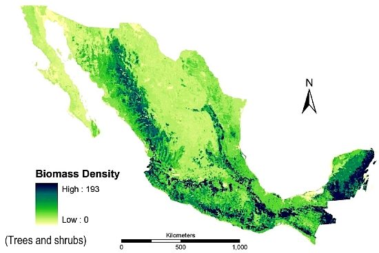
Biomass production in Mexico (Trees and bushes)

Biomass density in Mexico (trees and shrubs); from deJong et al, 2006.

But are all plant species equal? Should a giant redwood count the same as a dandelion? Certainly in terms of their ability to store carbon, larger plants are more valuable than smaller plants, though the total number of each species also matters. Storing carbon is important. When trees are cut down and burned (to clear the way for agriculture or settlement, for example) this stored carbon is released into the air and contributes to the processes causing global warming.

The term biomass is used to describe the total mass of living organic matter in a plant or in an area. The total biomass of a plant includes its bark, leaves and twigs. In a tropical forest, biomass includes every tree, shrub, sapling, vine, epiphyte and flower. About 50% of the biomass in most forests is carbon. The amount of biomass varies seasonally and is not necessarily stable over time, since plants increase their biomass as they grow. In a forest, the balance that matters in terms of sustainable forestry is the balance between the forest’s production of “new” biomass (through photosynthesis) and the consumption of some of its biomass by chopping, burning and natural decay. Clearly, human activity can directly impact this balance, but so too can natural events such as forest fires.

Bio-geographers have a great interest in assessing biomass since it provides a starting point for numerous models that attempt to estimate the effects of releasing some, or all, of this stored carbon on future global climates. Increasingly, their estimates from the use of remote sensing and satellite images are proving to be quite reliable when tested by comparing them to the biomass of the same area calculated from on-the-ground fieldwork.

The measure of biomass shown on the map is biomass density. Biomass density is the total amount of above ground living organic matter expressed as oven-dry metric tons per hectare. This map immediately reveals why conserving Mexico’s southern rainforests is so important. They are not only the most biodiverse areas of Mexico, their high biomass density values show that they also have far more than their fair share of Mexico’s total biomass. Conserving and managing these forests therefore needs to be a priority strategy in Mexico’s efforts to limit and mitigate climate change.

Sources:

The map comes from “Advances of Mexico in preparing for REDD” by Bernardus H.J. de Jong, Leonel Iglesias Gutiérrez and José Armando Alanís de la Rosa. Presentation given at the UNFCCC Workshop on Methodological Issues relating to Reducing Emissions from Deforestation and Forest Degradation in Developing Countries. Tokyo, Japan, 25 to 27 June 2008.

To read more about estimating biomass, see Estimating Biomass and Biomass Change of Tropical Forests: a Primer. (FAO Forestry Paper – 134) by Sandra Brown. FAO Forestry Paper 134. 1997.

Related posts:

How much drugs money is laundered in Mexico each year?

 Other  Comments Off on How much drugs money is laundered in Mexico each year?
Apr 212012
 

Despite this being an obvious question, there is no simple or generally accepted answer! However, a document published last month by Centro de Estudios Sociales y de Opinión Pública de la Cámara de Diputados (CESOP), entitled Lavado de dinero: indicadores y acciones de gobierno binacionales (“Money Laundering: bi-national indicators and government actions”) does offer some clues and estimates.

For example, according to Mexico’s tax authorities (SHCP), the nation’s financial system “gained” at least 10 billion dollars last year from unrecorded, presumably illicit, activities such as drug trafficking. North of the border, the US State Department believes that money laundering in Mexico accounts for between 8 billion and 25 billion dollars a year, while figures as high as 29 billion dollars have been offered in the US Congress.

Financial models developed by Global Financial Integrity and Columbia University in the City of New York suggest that the total “gains” from all forms of illegal activities in the USA are about 196 billion dollars (1.36% of US GDP), and that about 90% of this amount is laundered each year. The same models, applied to Mexico, suggest total crime-related profits of 38 billion dollars (3.6% of Mexico’s GDP), only 10-14 billion dollars of which is laundered into the formal economy.

If the models are to be believed, in the USA, 46% of the total amount laundered derives from drug trafficking, 32% from people trafficking, 15% from pirated goods and 7% from fraud. In Mexico, 41% of laundered money originates from drugs, 33% from people trafficking, 20% from pirated goods and 6% from fraud.

Despite the considerable variation in numbers, most of the figures and calculations fall within, or close to, the range of values (between 2 and 5% of global GDP) that is estimated by the International Monetary Fund to be laundered each year around the world.

Two major earthquakes jolted western Mexico (11/12 April 2012)

 Other  Comments Off on Two major earthquakes jolted western Mexico (11/12 April 2012)
Apr 112012
 

Two major earthquakes in two days! Fortunately, they struck in different sections along Mexico’s west coast, meaning that few if any people were shaken by both. The first earthquake struck in Michoacán on 11 April, and was felt over a wide area of central Mexico. This earthquake registered 6.5 on the Richter scale (preliminary estimates had originally suggested it was magnitude 7.0).

The La Mira earthquake, Michoacán (source: USGS]:

  • Time: Wednesday, April 11, 2012 at 17:55 local time
  • Location 18.272N, 102.732̊W
  • Depth 20 km (12.4 miles)
  • The epicenter was about 61 km (38 miles) NW from Lázaro Cárdenas, Michoacán, 130 km (80 miles) SSW from Uruapan, Michoacán, and 143 km (88 miles) NW of Zihuatanejo, Guerrero. This placed it relatively close to the community of La Mira in the state of Michoacán.
  • Only minor damage was reported following this earthquake, despite its magnitude.

The Santa Isabel earthquake

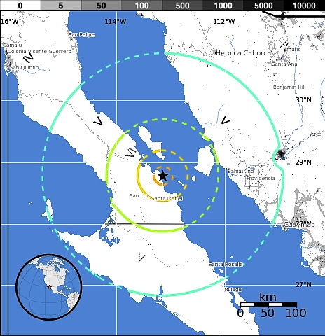
The following day (12.15 am local time on 12 April), an even larger earthquake, magnitude 6.9, hit further north in Mexico, close to the coast of Baja California. Its epicenter was 183 kilometers (113 miles) from Santa Rosalia (Baja California Sur) and 214 kilometers (132 miles) from Hermosillo (Sonora). This meant that its effects were greatest in areas where population is very sparse (see map), and fortunately, once again, there were no reports of any loss of life or major damage.

Few people live in the region struck by the Santa Isabel earthquake.

Few people live in the region struck by the Santa Isabel earthquake.Credit: USGS

These two earthquakes come less than a month after the major magnitude 7.4 earthquake that hit the states of Oaxaca and Guerrero on 20 March 2012. This ‘quake caused significant damage – and was followed by dozens of aftershocks, including one on 2 April that registered 6.0 on the Richter scale.

Now that several parts of this junction of tectonic plates have shifted in quick succession, everyone hopes that these earthquakes will have relieved enough pent-up pressure, and re-adjusted the plates  sufficiently, to prevent further earthquakes in the region in the near future.

Related posts:

Apr 092012
 

A recent report from researchers at the National Autonomous University of Mexico (UNAM) and the Metropolitan Autonomous University (UAM) confirms that the height of the water table below Mexico City is dropping by about one meter a year, as more water is pumped out of the aquifer than the natural replenishment rate from rainfall. About 60% of Mexico City’s drinking water comes from wells, with the remainder piped into the city, mainly via the Cutzamala system. The researchers say that up to 65% more water is taken from some parts of the Mexico City aquifer than the amount replaced each year by natural recharge.

As we reported in a previous post – Why are some parts of Mexico City sinking into the old lakebed? – this has resulted in parts of Mexico City sinking more than seven meters (23 ft) since 1891, with implications for water pipelines, drainage systems, building foundations and the city’s metro network, as well as an increased incidence of ground subsidence.

According to this latest research, the clay soil of the former lake bed below the city is sinking by between 6 and 28 cm/yr in most places, with rates in the southeast part of the city (where numerous wells have been drilled in recent years) sinking by up to 35 cm/yr.

How can the problem of sinking ground be resolved?

The report emphasizes the importance of conserving as much green space as possible within the city, to reduce runoff (and demands on the city’s drainage system) while simultaneously recharging aquifers. The three major alternatives, some combination of which is needed to resolve the problem are:

  • introduce more water-saving strategies so that demand does not continue to increase
  • bring more water from outside the Valley of Mexico (this would be costly and unpopular)
  • feed more wastewater back into the underground aquifers via “surface soaks”. As one example, the National Water Commission (Conagua) has announced plans to build a 200-million-dollar wastewater treatment plant (“El Caracol”) that will inject water back into the aquifer after treatment. It would be Mexico’s first ever large-scale reinjection project.

Perhaps not surprisingly, Mexico City residents pay more for their water than users anywhere else in the country, with an average water rate of US$1.23/cubic meter. Elsewhere, the two states sharing the arid Baja California Peninsula also have higher than average rates of $1.05/cubic meter (Baja California Sur) and $0.94/cubic meter (Baja California). The lowest rate in the country, well below the true cost of supplying water, is in Nayarit, and is just $0.25/cubic meter.

Within Mexico City, access to potable water is far from equally/fairly distributed across the city, as revealed by this thought-provoking quote :

In a study of water access in Mexico City, geographer Erik Swyngedouw found that “60 per cent of all urban potable water is distributed to three per cent of the households, whereas 50 per cent of the inhabitants make do on five per cent of the water”. Critical geographers like Swyngedouw ask us to take note of the spatial nature of power imbalances revealed in patterns of city design and growth: “mechanisms of exclusion… manifest the power relationships through which the geography of cities is shaped and transformed.”  [quote comes from page 31 of Nature’s Revenge: Reclaiming Sustainability in an Age of Corporate Globalization ; the reference is to Erik Swyngedouw’s Social Power and the Urbanization of Water: Flows of Power (OUP 2004).]

This grossly unequal distribution of potable water remains a critical problem that successive administrations in Mexico City and the surrounding State of México have done little to resolve.

Related posts:


Mexico’s political system at the state and municipal levels

 Other  Comments Off on Mexico’s political system at the state and municipal levels
Apr 072012
 

In a previous post – Mexico’s political system: the basics – we looked at the country’s federal political system. In this post, we look at how the political system works at the two other levels of government: state and municipal.

According to the Constitution of 1917, powers not granted to the Federal Government are reserved for the states. State constitutions roughly mirror the federal constitution. Each state has a popularly elected governor who serves one six-year term and cannot be re-elected. The popularly elected members of the state chamber of deputies serve three-year terms. Non-sequential re-election is permitted. Governors generally have more power than the chamber of deputies. State governments depend on the Federal government for much of their revenue, some of which they funnel to municipal governments. Each state has a Supreme Court of Justice with judges appointed by the state governor.

States are divided into municipalities. There are currently 2458 municipalities (counting Mexico City’s delegaciones or boroughs as municipios) which vary greatly in size and population. For example, the average population of Oaxaca’s 570 municipalities is about 6000 while the average population of Baja California’s five municipalities is over 500,000. Each municipality elects a new president and local council every three years.

Municipal governments have taxing authority but rely very heavily on financial support from state and federal sources. Municipalities are responsible for a variety of public services, including water and sewerage; street lighting and maintenance, trash collection and disposal, public safety and traffic, supervision of slaughterhouses, and maintenance of parks, gardens and cemeteries. Municipalities are also free to assist state and federal governments in the provision of elementary education, emergency fire and medical services, environmental protection and the maintenance of historical landmarks.

A matter of scale: Mexico compared to Spain

 Other  Comments Off on A matter of scale: Mexico compared to Spain
Mar 262012
 

Scale matters, especially when two countries or regions are going to be compared. A case in point is depicted on this Mexican airmail stamp from 1977 issued to celebrate the resumption of diplomatic relations between Mexico and Spain. Mexico had broken off relations with Spain in 1939 at the end of the Spanish Civil War when Francisco Franco gained control. Following that war, more than 30,000 Spaniards sought refuge in Mexico, giving a significant boost to the country’s entrepreneurs. It took until 28 March 1977 for diplomatic relations between Mexico and Spain to be restored.

The outline maps on the stamp show Mexico and Spain as having approximately the same area. Presumably this was to ensure that the stamp would be seen as politically-correct, even if not spatially-correct, and would make the two countries look like equal partners. In real life, or on any equal-area map projection,  Mexico (almost 2 million square kilometers) is about four times as large as Spain (close to 50,000  square kilometers).

If the maps were drawn proportional to population, then Mexico would be more than twice as large, since its population of about 112 million (2010) is more than double that of Spain (48 million in the same year). This difference is widening with the years, since Spain’s population growth rate has fallen to about 0.6%/year, while Mexico’s (which has also fallen) remains significantly higher at about 1.1%/year.

Mexico has more World Heritage sites than any other country in the Americas

 Other  Comments Off on Mexico has more World Heritage sites than any other country in the Americas
Mar 172012
 

The status of World Heritage site is a UNESCO (United Nations Educational, Scientific and Cultural Organization) denomination. The status is conferred on selected sites under the terms of “The Convention Concerning the Protection of the World Cultural and Natural Heritage”, adopted at UNESCO’s 17th General Conference in November 1972 and subsequently ratified by 189 member states.

Nations were invited to submit their proposals for any cultural or natural sites that they considered “of outstanding universal value”, and therefore eligible for inclusion on the World Heritage list. All proposals have to be approved by a special UNESCO World Heritage Committee.

The attraction of having a site classified as a World Heritage site is that it affords extra possibilities for obtaining technical co-operation in matters relating to conservation, for international assistance for research, training and equipment, and for emergency assistance in the event of damage due to specific natural or man-made disasters. All these sites are also valuable as cultural or environmental tourism destinations.

The list was first published in 1978, at which time it mainly featured European sites. Since then, regular additions have been made. As of March 2012, the list includes 936 locations in 153 member states. Of these sites, 725 are considered to have cultural significance, 183 to have natural importance and there are also 28 which share both cultural and natural value.

Mexico has 31 sites on the list, considerably more than any other country in the Americas. For example, the U.S. has 20 (together with a share of a 21st that straddles the border with Canada), Brazil 17 (as well as one jointly held with Argentina), Canada 14 (plus the joint U.S.-Canada site) and Peru 11.

Worldwide, only five countries have more World Heritage sites than Mexico. Four of these countries are in Europe: Italy, Spain, Germany and France. The other country is China.

Mexico’s existing World Heritage sites

Date added to list  – Name of site (state in brackets)

1987 Sian Ka’an biosphere reserve (Quintana Roo)
1987 Pre-Hispanic city and national Park of Palenque (Chiapas)
1987 Historic Center of Mexico City and Xochimilco (Mexico D.F.)
1987 Pre-Hispanic city of Teotihuacan (State of Mexico)
1987 Historic Centre of Oaxaca and archaeological site of Monte Alban(Oaxaca)
1987 Historic Centre of Puebla (Puebla)
1988 Historic town of Guanajuato and Adjacent Mines (Guanajuato)
1988 Pre-Hispanic city of Chichen-Itza (Yucatán)
1991 Historic Centre of Morelia (Michoacán)
1992 Pre-Hispanic city of El Tajin (Veracruz)
1993 Whale Sanctuary of El Vizcaino (Baja California)
1993 Historic Centre of Zacatecas (Zacatecas)
1993 Rock Paintings of the Sierra de San Francisco (Baja California)
1994 Earliest 16th-Century monasteries on the slopes of Popocatepetl (Morelos)
1996 Prehispanic town of Uxmal (Yucatán)
1996 Historic Monuments, Zone of Querétaro (Querétaro)
1997 Hospicio Cabañas, Guadalajara (Jalisco)
1998 Historic Monuments, Zone of Tlacotalpan (Veracruz)
1998 Archeological Zone of Paquimé, Casas Grandes (Chihuahua)
1999 Historic fortified town of Campeche (Campeche)
1999 Archaeological Monuments, Zone of Xochicalco (Morelos)
2002 Ancient Maya City and biosphere reserve of Calakmul (Campeche)
2003 Franciscan Missions in the Sierra Gorda (Querétaro)
2004 House and Studio of Luis Barragán (in Mexico City)
2005 Islands and protected areas of the Gulf of California
2006 Agave landscape and old tequila-making facilities in Amatitán, Arenal and Tequila (Jalisco)
2007 Central University City Campus of the Universidad Nacional Autónoma de México (UNAM) (Mexico City)
2008 Monarch Butterfly Biosphere Reserve (Michoacán and State of México)
2008 San Miguel de Allende and the Sanctuary of Jesús de Nazareno de Atotonilco (Guanajuato)
2010 Camino Real de Tierra Adentro, the 2,900 kilometer historic route linking Mexico City to Santa Fe in New Mexico
2010 Prehistoric caves of Yagul and Mitla in the Central Valley of Oaxaca

Mexico’s proposed World Heritage sites:

Mexico has formally proposed numerous additional sites for World Heritage Status. The applications are coordinated by the National Anthropology and History Institute (Instituto Nacional de Antropología e Historia), better known by its Spanish acronym INAH. Proposals include:

1.  Historic town of San Sebastián del Oeste (Jalisco)
2. Tule (ahuehuete) tree of Santa María del Tule (Oaxaca)
3. Zempoala aqueduct, a project of Padre Tembleque (Hidalgo and State of Mexico)
4. Monterrey’s old industrial facilities, including a foundry, brewery and glassworks (Nuevo León)
5. The Aguascalientes railroad station and residential complex (Aguascalientes)
6. The Museo Casa Estudio Diego Rivera and Frida Kahlo (Mexico D.F.)
7. Ludwig Mies van Der Rohe and Félix Candela’s industrial buildings, including the offices of Bacardí y Compañía (State of Mexico)
8. Historic city of San Luis Potosí (San Luis Potosí)
9. Chapultepec Woods, Hill and Castle (Mexico D.F.)
10. Historic town of Alamos (Sonora)
11. Pre-Hispanic city of Cantona (Puebla)
12. The church of Santa Prisca in Taxco (Guerrero)
13. The former Jesuit college in Tepotzotlán (State of Mexico)
14. The churches of the Zoque province (Chiapas)
15. The pre-Hispanic city of Chicomostoc-La Quemada (Zacatecas)
16. Archaeological monuments, zone of Mitla (Oaxaca)
17. Cuatrociénegas flora and fauna reserve (Coahuila)
18. Franciscan convent and Our Lady of the Assumption cathedral in Tlaxcala (Tlaxcala)
19. Historical town of the Royal Mines of Cosala (formerly known as the Royal of the Eleven Thousand Virgins of Cosala) (Sinaloa)
20. Huichol Route used by Huichol Indians through their sacred sites to Huiricuta (San Luis Potosí) (sometimes spelt as Wirikuta)
21. The former textile factory La Constancia Mexicana and its housing area (Puebla)
22. The Lacan-Tún—Usumacinta region (Chiapas)
23. The Banco Chinchorro Biosphere Reserve(offshore in Quintana Roo)
24. The El Pinacate and the Great Altar Desert Biosphere Reserve (Sonora)
25. The Selva El Ocote Biosphere Reserve (Chiapas)
26. Sotáno del Barro, a 450-meter-deep sinkhole (Querétaro)
27. Tecoaque archaeological site (Tlaxcala)
38. Valle des Cierges, including Montevideo Canyon (Baja California)

Not all sites are accepted. For instance, Mexico’s rejections include the Lake Pátzcuaro region, in the state of Michoacán, and the El Triunfo nature reserve.

Mexicans are justly proud of their nation’s history and culture, and have always been prepared to share them with visitors. By getting so many locations on UNESCO’s list of World Heritage sites, the country is reaffirming its commitment to trying to ensure that its cultural and natural treasures are well protected for future generations. Any of the places mentioned in this article is well worth visiting and exploring. In some cases, it is possible to construct fascinating “itineraries” combining several of the sites in a single trip.

Bear in mind, though, that there are also numerous attractions not yet listed as World Heritage sites that probably deserve to be included in the future. For starters, how about Paricutin Volcano, one of only a handful of new volcanoes to appear on land in historic times? Or how about the Copper Canyon region, with its grandiose scenery and indigenous Tarahumar population?

For more information:

Related articles:


How does money laundering work, and what is being done about it?

 Other  Comments Off on How does money laundering work, and what is being done about it?
Mar 152012
 

How is drugs money laundered?

Drug funds have allegedly financed hotels, car dealerships, bus companies, airlines, casinos, beauty salons, skyscrapers and restaurants, as well as the lavish lifestyles of individual cartel members who acquire gold jewelry, expensive cars, vehicles, yachts and planes.

Trade-based laundering” is on the rise. Drug cartels are reported to be increasingly using regular cross-border trade to launder their ill-gotten gains. Profits from the sale of drugs in the USA and elsewhere are used to purchase truckloads of goods such as fruit, toys and fabric, which are then sent south to Mexico to be sold for pesos. This cross-border trade effectively changes US dollars into pesos with few questions being asked.

In a variation on the theme, the dollars are used to buy things such as toys or fabric from a third country such as China. The goods are then exported to Mexico and resold. The net effect is the same: dollars become pesos, ready to help pay for the next shipments of drugs. Trade-based laundering is hidden in the massive regular trade-flows between Mexico and the USA which total almost 400 billion dollars a year. Authorities always seem to be one step behind the cartels, partly because, as this LA Times article points out, cartel bosses are “among the world’s most expert transnational entrepreneurs”. Indeed, the sheer scale of the drug money flows threatens to overwhelm Mexico’s police and security forces.

Drug money is being transferred via a variety of means, from cash transfers (formal or informal) and deposits in bank accounts to the purchase of goods and services (including pirated merchandise).

How can money laundering be reduced?

In recent years, Mexican authorities have focused more attention on chasing the money involved in the drugs trade. Government officials claim that more than $50 billion in drugs money is laundered each year, more than the value of Mexico’s oil exports and equivalent to 3% of GDP. Mexico’s laws are barely keeping up with the ingenuity of money launderers, and convictions for money-laundering are rare.

What has Mexico done to try and prevent money laundering? There are now strict limits on the use of US dollars in Mexico, and on cash deposits into bank accounts. The latest tightening of the rules extends the reporting of higher value US dollar transactions to all real estate offices, car dealerships, betting parlors, art galleries and public notaries. Any purchases using cash for items such as vehicles costing over about $14,000, and for real estate over about $70,000 are now automatically reported to federal authorities.

As Mexico tightens its accountancy rules, drug gangs may have to keep more of their funds in the USA or go elsewhere. Mexico is becoming a much less friendly place for the drug cartels’ informal “retirement funds”.

Mexico City has largely escaped drug violence

 Other  Comments Off on Mexico City has largely escaped drug violence
Mar 082012
 

Previous posts have analyzed drug war death rates in Mexican states, cities over 500,000, the most violent municipalities and areas of particular interest to expatriates. This post focuses on Mexico City or D.F. (Distrito Federal). We focus on D.F. because the rate of drug war deaths is exceptionally low there, less than one eighth the national average.

In all of 2010 there were 191 drug war deaths in D.F. [note 1] compared to 122 in the first nine months of 2011. [note 2] While this might sound like a large number of deaths, we must remember that there are almost nine million people in D.F.  The 2011 drug war death rate per 100,000/yr in D.F. was 1.8 compared to a national rate 15.3 and a rate of 134 in Acapulco. [note 3] The rate for D.F. declined 15% from the 2010 rate while the rates for all of Mexico and Acapulco increased by 13% and 187% respectively. Today, people seeking better security are moving into D.F. from other cities in the country.

Why are the rates in D.F. so low? In previous decades D.F. was thought to be one of the most violent places in the country, but this is no longer the case. The total murder rate for D.F. is half the national rate [note 4] and less than a third that of Washington, DC. [note 5] A major reason is that D.F. has a more competent, better organized, better paid and less corrupt police force than any of the other cities. The fact that the national government is in D.F. also helps as do more effective youth programs. That D.F. has higher overall income levels is also a factor. Some even speculate that major cartel bosses have family in D.F. and have an unspoken agreement to avoid violence in the capital [note 6].

The drug war death rates are quite low in all parts of the city. The wealthy delegation of Cuajimalpa in western D.F. had zero deaths in 2011 compared to 11 a year earlier. In 2010 it had the city’s highest rate of 5.9, but this was still less than half the national average. Relatively sparsely populated Milpa Alta in the southeast also had zero deaths in 2011. Cuauhtemoc and Venustiano Carranza, two central delegations, had the highest rates in 2011, but they both less than a third the national average.

The 13 suburban municipalities adjacent to D.F. in the State of Mexico experienced 331 drug war deaths in 2011, almost three times the number in D.F. These suburbs with a total population of just over six million had a combined drug war death rate of 7.3, four times as high as D.F. While the death rate in these municipalities increased 42% over the 2010 level, it was still less than half the national average. Based on the data presented above, it is not surprising that people worried about drug violence would rather live in or near D.F. than in most other cities, especially those in northern and western Mexico.

Notes:
  1. “Mexican drugs war murders data mapped”, The Guardian, posted by Johanna Tuckman, Jan 14, 2011. http://www.guardian.co.uk/news/datablog/2011/jan/14/mexico-drug-war-murders-map. For data see: http://www.google.com/fusiontables/DataSource?dsrcid=393962.
  2. “Van mas de 47 mil muertos por nacroviolencia: PGR”, El Universal, 12 January 2012, http://www.eluniversal.com.mx/notas/822078.html.
  3. The rates for 2011 were adjusted because data are available for only the first nine months of the year.
  4. “Is Mexico City safe from drug cartel war – or the next target,” CNN, January 17, 2012, .http://www.cnn.com/2012/01/17/world/americas/mexico-city-security/index.html
  5. “Mexico’s violence not as widespread as seems,” USAToday, 3 August 2010. http://www.usatoday.com/news/world/2010-08-03-Mexico-drug-violence_N.htm.
  6. Is Mexico City safe from drug cartel war — or the next target,” CNN, January 17, 2012, .http://www.cnn.com/2012/01/17/world/americas/mexico-city-security/index.html.
Mar 072012
 

Artificial reefs are usually created by sinking a ship (after it has been thoroughly cleaned to prevent any toxic substances from entering the marine environment) or some other massive metal or concrete structure. Marine sediments gradually collect in, on, and around the objects, which are rapidly colonized by marine life. For rapid reef building, individual corals are sometimes transplanted onto the new structures.

The latest artificial reefs in Mexico are works of art. Jason deCaires Taylor, a British artist and dive instructor, has built an extraordinary collection of concrete sculptures and then carefully positioned them underwater in a marine park near Cancún, Mexico’s most popular tourist resort. The objective was to create an underwater “museum”, which divers and snorkelers can explore, while simultaneously providing a variety of structures for sea-life to inhabit.

One of the more remarkable sculptures is entitled “The Archive of Lost Dreams”. It features a librarian (pet dog at his feet) caring for and cataloging a collection of messages in bottles into “hopes”, “fears”, etc.. Another of the sculptures is a full-size model of the iconic Volkswagen Beetle.

The art-park, begun in 2009, is planned to house 400 sculptures in all and is billed as the largest underwater art museum in the world.

Another work now under construction is modeled on the ears of every child in a grade school class; it will be fitted with a hydrophone to enable marine biologists to analyze reef sounds (New Scientist, 17 December 2011).

Marine grade concrete is used for the exhibits, which are built to withstand a Category 4 hurricane. It is anticipated that hard and soft corals will eventually cover the sculptures, partially making up for the damage done to natural reefs by storms, tourists and boats, and reducing visitor pressure on the natural reefs. The natural reef off the coast of Quintana Roo, is part of the Mesoamerican Reef, the longest coral reef in the northern hemisphere and the second largest coral reef in the world. It is under constant pressure from coastal developments such as new hotels and cruise ship berths, as well as from climate change. The marine park near Cancún is visited by about 800,000 tourists a year.

The artist may think his idea is laudable, but not everyone is convinced. Critics argue that art works are not a good fit with the natural world, and why try to improve on nature? In addition, if artificial reefs are not carefully sited and well managed, they may be torn loose during storms and then cause extensive damage to any nearby natural reefs.

Related posts:

Mar 052012
 

In a previous post–The development of Huatulco, the tourist resort in southern Oaxaca–we looked at how the tourist resort of Huatulco was created by Mexico’s National Tourism Development Fund (Fonatur) on a series of small bays in the state of Oaxaca. Clearly, this development was very much “top-down” and it has been widely criticized from many distinct points of view. From a geographical perspective, the most important criticisms have arisen from researchers such as Evelinda Santiago Jiménez and David Barkin, co-authors of a short article entitled “Local Participation and Sustainability: a study of three rural communities in Oaxaca, Southern Mexico.”

Their view is that government programs, such as Huatulco, “are generally conceived for areas where there are resources that can be transformed into commodities”. In the case of Huatulco, this means that “access to public services, such as potable water, is designed to satisfy the demands of the visitors and affluent local service providers, while the majority suffer from inadequate supplies and must accept the conditions imposed on them.” Santiago Jiménez and Barkin see this as “a new form of colonization, implemented in the name of modernity to expropriate communal lands with minimal guarantees and compensation; a process of excluding local peoples; a way to subordinate the local inhabitants…; and a process than causes harm to the environment.”

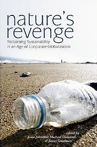
The article by Santiago Jiménez and Barkin appears in a book entitled Nature’s Revenge: Reclaiming Sustainability in an Age of Corporate Globalization (University of Toronto Press/Garamond 2006). This book, which in its own words, “proposes a radical definition of sustainability, reclaiming the word from the rhetoric typically used by corporations and governments to facilitate unrelenting economic growth and the notion of ‘business as usual'”, is well worth reading.

The authors argue for adopting a “commons”-based approach, where the term “commons” is understood to include not only the idea of commonly-held or shared rights and property (such as water, air, soil) but also the “social commons” comprised of community knowledge and culture. In stressing “the complex interrelations that exist at local, regional, national, continental, and global levels of human organization”, the authors critique advocates of “localism” and argue that “there can be no simple solution confined to one particular scale of action.”

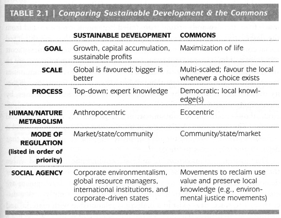
A table in Chapter Two (Who cares about the Commons? by Josée Johnston) summarizes the key differences between sustainable development (as used by corporations and governments) and the commons-based approach favored by the book’s authors:

Table 2.1 of "Who cares about the Commons" by Josée Johnston.
Table 2.1 of “Who cares about the Commons” by Josée Johnston.

It is an example of this commons-based approach that Santiago Jiménez and Barkin examine in their chapter. They analyze an alternative, locally initiated project, based on the Integrated Development of Natural Resources (Administración Integral de los Recursos Naturales, AIRN), which stands in sharp contrast to Fonatur’s “top-down” development model. The AIRN approach recognizes that local communities have a symbiotic relationship with their surrounding natural environment that is “crucial for mutual survival”. It also recognizes that the community-environment links are dynamic, not static, and will change or evolve with time as the community develops.

AIRN proposals aim, essentially, to speed up this development process, helping to find new productive projects for the communities while managing ecosystems effectively and sustainably. The success of AIRN development projects relies on an active participation by the local community to identify issues, opportunities and ways to progress. It is crucial that the local people are equal partners in the decision-making process.

In the Huatulco area, the Center for Ecological Support (Centro de Suporte Ecológico, CSE), an NGO, adopted an AIRN approach to devise appropriate strategies to reverse the damage done to water resources by the construction and expansion of Huatulco tourist resort, which had destroyed forest cover, reduced infiltration and abstracted water from the aquifer that underlies the Copalita River. The CSE proposed a reforestation program to actively regenerate (not just protect) the forests throughout the basin, including parts of the Southern Sierra Madre (Sierra Madre del Sur). At the same time, the CSE helped local inhabitants to explore new (alternative) sources of employment and income based in their communities, which offered them a viable option to abandoning their land and accepting menial low-paid  jobs in the tourist resort or elsewhere.

Santiago Jiménez and Barkin looked at three small villages that had participated in the AIRN proposals made by the CSE: Santa María Xadani, Santa María Petatengo and El Achiote. Each village had participated in different ways, and with varying degrees of success. Close familial ties in Petatengo, for example, ensured more community support than in Xadani where internal divisions reduce social cohesion. El Achiote is a small “rancho” of 14 families, all of whom participated in the reforestation project. The families also combine to carve and paint the colorful Oaxacan whimsical wooden figures known as “alebrijes”. The settlement gained electricity service in 2000 and telephone service in 2001. Sadly, a combination of circumstances led to many local inhabitants migrating away from the area in search of better incomes and the CSE was forced to suspend its operations.

The authors point out that development plans have to take account of three very different concepts of time. The local communities in this region view time as somewhat flexible, preferring to make decisions by consensus, rather than in order to meet any deadline. Organizations providing funding for projects see time in terms of deadlines and financial commitments. Local and state governments view time in terms of political cycles, with a project having more chance of success if it is launched early on in an administration’s term. Santiago Jiménez and Barkin also emphasize the importance of projects having an effective mediator (as the CSE proved to be) “capable of balancing the rhythms of Western culture, of nature, and of traditional culture”.

Mexico badly needs more examples of successful mediators, particularly where large scale tourism projects are concerned.

Related posts:

Drug war death trends in areas of Mexico of interest to foreign tourists and retirees

 Other  Comments Off on Drug war death trends in areas of Mexico of interest to foreign tourists and retirees
Mar 022012
 

Non-Mexicans are far more interested in some parts of Mexico than others. These areas of interest may be well-known tourist destinations, have thousands of expatriate residents or are located on major expatriate travel routes. Mexico’s major cities, which are also of interest to foreigners, were discussed in a previous post. This post focuses on 24 municipalities of less than 500,000 population. (These are listed alphabetically in the table linked to at the end of the post.)

Drug war death rates vary enormously among the 24 communities. Data released by the Office of the President [note 1] indicate that some of these municipalities have extremely high drug war death rates. The number of deaths in Zihuatanejo went from 16 in 2010 [note 2] to a startling 90 in the first nine months of 2011. This results in a rate of 115 deaths per 100,000 population/yr or over seven times the national average of 15.3 [note 3]. This places Zihuatanejo among the 20 most dangerous communities in Mexico (see earlier post) along with the other famous Guerrero beach resort of Acapulco.

Other dangerous municipalities listed in the table are Tepic, Nayarit at 69 (4.5 times the average); Mazatlán at 58 (3.8 times the average) and Nuevo Laredo at 50 (3.3 times the average). Thousands of expatriates live in Mazatlán while thousands drive through Tepic and Nuevo Laredo. The temporal trends in these dangerous cities vary widely. Between 2010 and 2011, the rate for Zihuatanejo went up 650% while Nuevo Laredo’s increased by 67% and Tepic edged up 14%. The rate for Mazatlán was down 20%.

The most worrisome trend is the very rapid drug violence increase in Veracruz State. From 2010 to 2011 the death rate for Xalapa went up 1,066%. In 2010 there were a total of 15 drug war deaths in Xalapa, Boca del Río and Veracruz City combined; but in the first nine months of 2011 this went up to 284. It remains to be seen if this dreadful trend will continue into 2012 and beyond.

Other cities in the table with rates significantly above the national average include Nogales with a rate of 28, down 68% from 2009. The rate for Playas de Rosarito (Baja California) was up 41% to 28, nearly double the average of 15.3. Matamoros’ rate increased 13% to 20 while Cuernavaca’s was down 49% to 19.

The death rates in towns near Lake Chapala varied markedly. The rate for Ixtlahuacán de los Membrillos dropped from 34 in 2010 to 16 in 2010, but was still above the national average and twice the rate of neighboring Chapala. The rate for nearby Jocotepec of 13 was between the other two. Though local media suggest a growing drug violence problem in these three communities, the actual number of deaths dropped from 24 in 2010 to 12 in 2011. The death rate for the three communities dropped from 34% above average in 2010 to 33% below average in 2011.

The great news is that three of communities in the table—Bahia de Banderas, Guanajuato and San Miguel de Allende—had zero drug war deaths in the first nine months of 2011, compared to 27 in 2010. Bahia de Banderas, in Nayarit just north of Puerto Vallarta, is of particular interest because it had 19 deaths in 2010. If this precipitous drop is not a statistical anomaly it represents a major anomaly because the number of deaths in the adjoining community of Puerto Vallarta almost doubled from 15 in 2010 to 28 in 2011; furthermore there were 196 deaths in nearby Tepic.

Several tourist areas had drug war death rates less than a sixth the national average. These include Ensenada, La Paz and Los Cabos on the Baja Peninsula as well as Oaxaca City. Not far behind was Playa del Carmen with a rate about one quarter of the average. These data suggest that tourists worried about drug violence and seeking a beach resort vacation might lean toward Baja California Sur or the Maya Riviera instead of Acapulco, Zihuatanejo or Mazatlán.

Notes:

[1] “Van mas de 47 mil muertos por nacroviolencia: PGR”, El Universal, 12 January 2012, http://www.eluniversal.com.mx/notas/822078.html.

[2] “Mexican drugs war murders data mapped”, Theguradian, posted by Johanna Tuckman, Jan 14, 2011. http://www.guardian.co.uk/news/datablog/2011/jan/14/mexico-drug-war-murders-map. For data see: http://www.google.com/fusiontables/DataSource?dsrcid=393962.

[3] The rates for 2011 were adjusted because data are available for only the first nine months of the year.

Which Mexican communities have the highest drug war death rates?

 Other  Comments Off on Which Mexican communities have the highest drug war death rates?
Feb 232012
 

In a previous post we noted that big Mexican cities with populations of over 500,000 have drug war death rates about 40% higher than the rest of Mexico. However the highest rates of all are in small northern municipalities which have experienced very high levels of drug violence.

Mier, Tamaulipas was the most dangerous municipality in 2011 as it was in 2010. Though the number of drug war deaths in the town of 4,768 (2010) decreased from 93 in 2010 [note 1] to 50 in the first nine months of 2011 [note 2], it still led the country with 1,398 drug war deaths per 100,000/yr [note 3]. This is 91 times the rate for all of Mexico which was 15.3 in 2011 and also over ten times as dangerous as Acapulco, the large city with the highest rate of drug violence. Actually the death rate per population for Mier is probably higher because the mayor estimates that a third of the population may have fled the violence-prone town [note 4]. Mier is only about eight kilometers (five miles) from the Texas border and roughly midway between Nuevo Laredo and Reynosa. The municipality may be a bit more peaceful now that the Mexican military has occupied the town.

Guerrero, Mier’s immediate neighbor to the northwest with a population of 4,468, ranked second with a death rate of 1,045 or roughly 68 times the average. Both Guerrero and Mier are located between two warring drug cartels, the Zetas and the Gulf Cartel. Mier’s other neighbor along the Rio Grande, Miguel Alemán, fared somewhat better. Its death rate dropped from 407 in 2010 to 114 in 2011; but its 2011 rate was still over seven times the national average. The data reveal that municipalities along the border between Nuevo Laredo and Reynosa are among the most dangerous in all of Mexico. Interestingly, the rate for Reynosa itself was only 11 or about 27% below the average.

In third place is San Fernando, also in Tamaulipas, with a death rate of 680, about 44 times the average. This community of 57,220 suffered 292 deaths in 2011. Over half of these deaths were discovered in mass graves of Central Americans who were trying to immigrate to the US, but were kidnapped and murdered by drug cartels.

Next on the list are three small municipalities in Chihuahua – Guadalupe (rate of 496), Gran Morelos (373) and Cusihuiriachi (369). The 2011 death rates in these towns were 24 to 32 times the national average. While the rate for Guadalupe declined 42% since 2010, the rates for Gran Morelos and Cusihuiriachi were up 50% and 150% respectively. As mentioned in an earlier post, the State of Chihuahua had the highest 2011 drug war death rate among Mexico’s 32 states.

Drug war death totals in small communities can change dramatically from year to year. For example, Saric, Sonora with a population of 2,703 had 30 deaths in 2010 and zero in 2011. General Bravo, Nuevo Leon had 18 deaths in 2010 and zero in 2011 while Yecora, Sonora had 18 deaths in 2010 and only one in 2011. The number in General Treviño, Nuevo León went from 21 down to only two, but it still had the 8th highest rate among Mexico’s municipalities.

On the other hand, drug war deaths in Boca del Rio, Veracruz went from 2 in 2010 to an alarming 94 in 2011. This resulted in a rate increase of 6,167% and a rate six times the average. The rate for Zihuatanejo de Azueta, Guerrero increased by 650%; that of Yurécuaro, Michoacán went up by 452% while that for Cosalá, Sinaloa was up 317%, giving it a rate 13 times the average.

Zihuatanejo de Azueta is different than many of the other communities with very high drug war death rates because it has a rather large population of 104,609 and includes the famous international resort of Ixtapa. The number of drug war deaths in the municipality went from 16 in 2010 to a very disturbing 90 in 2011, giving it a death rate of 115, almost as high as Acapulco’s rate of 134. Certainly, the high drug war death rates in Zihuatanejo and Acapulco have damaged their tourism industries.

Twenty municipalities had drug war death rate in 2011 higher than 100 per 100,000/yr or about seven times the national average (see table). Two of these are the large municipalities of Ciudad Juárez and Acapulco. The 20 communities are spread across six northern and western states: six in Chihuahua, five in Tamaulipas, three in Guerrero, two in Sinaloa and Michoacán, and one each in Sonora and Nuevo León. Before randomly traveling in areas of these states, it would be a good idea to check local media and bulletin boards for indications of recent drug violence.

Notes:

[1] “Mexican drugs war murders data mapped”, The Guardian, posted by Johanna Tuckman, Jan 14, 2011. http://www.guardian.co.uk/news/datablog/2011/jan/14/mexico-drug-war-murders-map. For data see: http://www.google.com/fusiontables/DataSource?dsrcid=393962.

[2] “Van mas de 47 mil muertos por nacroviolencia: PGR”, El Universal, 12 January 2012, http://www.eluniversal.com.mx/notas/822078.html.

[3] The rates for 2011 were adjusted because data are available for only the first nine months of the year.

[4] Christopher Sherman (AP), “Drug War: Despite army takeover, fear grips Mexican town”, Press-Telegram, Long Beach, CA, Dec 7, 2011. http://www.presstelegram.com/breakingnews/ci_19488405

Drug war deaths in Mexico’s biggest cities

 Other  Comments Off on Drug war deaths in Mexico’s biggest cities
Feb 182012
 

Drug war deaths occur in communities of all sizes, but they are a bit more likely in the biggest cities. However, there are gigantic geographic variations. For example, Acapulco, with a population of about 790,000, had 795 drug war deaths in 2011 (Jan–Sept) [note 1] while there were zero drug war deaths in Mérida, with 828,000 residents. Clearly drug cartel battles are very geographically concentrated.

Compared to the rest of the country, Mexico’s 37 largest municipalities with populations of over 500,000 experience about 40% more drug war deaths per 100,000 population than the rest of the country. These big cities account for about 36.5% of Mexico’s population and 44% of the drug war deaths in both 2010 and 2011.

In 2010, Ciudad Juárez was the drug war hotspot with 2,736 deaths for a rate of 206 per 100,000/yr compared to the national rate of 13.6 [note 2]. This dropped by a surprising 41% in 2011 to a rate of 121 [note 3]; but  Ciudad Juárez still led the nation’s death toll with 1,206 deaths. Acapulco’s 795 deaths gave it the highest rate among big cities of 134, up a frightening 186% over 2010. Other dangerous big cities with high drug war death rates include Torreón with a rate 99 (up 100%), Durango with 89 (up 244%), Chihuahua with 65 (down 20%) and Culiacán with 57 (down 17%).

Tijuana used to be a major center of drug violence, but not anymore. Between December 2006 and December 2009, it experienced 1,195 drug war deaths, behind only Ciudad Juárez with 3,699 and Culiacán with 1,303. Its death rate for that period was over four times the national average. But the number of deaths dropped from 472 in 2010 to 183 in 2011 bringing the rate down to 15.6, just above the national average of 15.3. In nearby Mexicali, the rate was only 4.1 in 2011, about a quarter of the average. The state of Baja California is no longer a key battleground in the Mexican drug war.

Drug violence deteriorated most rapidly in Veracruz City which went from 9 deaths in 2010 to 155 in 2011 resulting in a rate increase of almost 2,200%. This increased the rate to 37, nearly two and a half times the national average. Smaller cities in Veracruz State also experienced rapid increases. For example, Jalapa went up 1,066% and Bocas del Rio was up 6,167%. For the state as a whole, the rate was up over 300%. Clearly, the drug war has reached Veracruz.

Drug war violence has also increased rapidly in Monterrey where the number of deaths increased from 179 in 2010 to 399 in 2011, more than doubling its death rate. Deaths in Monterrey’s two large suburbs of Guadalupe and Apodaca also went from 91 to 220. While the rate in Monterrey was just above the national average in 2010, in 2011 it was up to 47, three times the average. Deaths in nearby Saltillo also went up rapidly, from 15 to 50, pushing its rate up by 344%.

Guadalajara also experienced an upsurge in drug violence. While its death rate went up 61% to 7.3 in 2011, this is still less than half the national average. However, the 2011 data do not include the 26 bodies dumped in the city in November 2011. Death rates were also up nearly 50% in Guadalajara’s two big suburbs of Zapopan and Tlaquepaque.

Surprisingly the Mexico City Federal District has been relatively free of drug violence. Total drug war deaths dropped from 191 to 122 pushing its 2011 rate down to only 1.8 deaths per 100,000/yr. This is only about one eighth the national rate. A future post will provide a more detailed analysis of drug violence in Mexico City.

In addition to Mérida, Tuxtla Gutierrez in Chiapas also had zero deaths in 2011. Other big cities with very low drug war death rates include Puebla (0.6), Querétaro (0.8), León (1.9), Toluca (2.1) and Villahermosa (2.5). Apparently drug cartels and their enemies have not been very active in these cities.

Notes:

[1] All the references for 2011 are for January through September based on the data released by Mexican Government

[2] “Mexican drugs war murders data mapped”, The Guardian, posted by Johanna Tuckman, Jan 14, 2011. http://www.guardian.co.uk/news/datablog/2011/jan/14/mexico-drug-war-murders-map. For data see: http://www.google.com/fusiontables/DataSource?dsrcid=393962.

[3] The rates for 2011 were adjusted because data are available for only the first nine months of the year.

Can Mexico’s decline in cacao production be reversed?

 Other  Comments Off on Can Mexico’s decline in cacao production be reversed?
Feb 162012
 

In a previous post, we looked at The geography of cacao production in Mexico. and saw how the area under cultivation and production have both fallen sharply since 2003. This post examines two recent projects that aim to reverse this recent trend of a steep decline in Mexico’s cacao production.

Major organic cacao project

The Agriculture Secretariat (Sagarpa) has several projects designed to rejuvenate Mexico’s cacao-growing sector. These include the production of young plants of high-yielding varieties, primarily in Tabasco for use in several southern states. Propagation method is either via grafting or via cuttings. (Tabasco is a leading centre for the development of tropical crops such as cacao, coconut palm and oil palm.)

In addition, Sagarpa is introducing improved methods of cultivation, harvesting and processing. The Secretariat is supporting a multi-phase plan to turn Mexico into the leading producer of organic cacao in the Americas. In the early phases, Maya Biosana will plant one million cacao trees to create 500 hectares (1200 acres) of irrigated orchards in 12 communities near Chetumal in Quintana Roo. The plan is to follow-up with similar numbers of new trees on additional land annually for another three years. The trees are expected to yield 2.4 metric tons of cacao per hectare (destined for high quality chocolates) and provide up to 2,000 additional jobs. [Note that the project is not without its critics, and we intend to write more about this in a future post].

NGO support for cacao producer cooperatives in Tabasco

One specific example of a project helping cacao farmers is the Chontalpa Cacao Presidium, a project initiated by the Slow Food Foundation. Tabasco’s most productive region for cacao is Chontalpa, which has ideal conditions for cacao cultivation and is the area where the criolla variety of cacao is thought to have originated.

Traditionally, farmers in the Chontalpa area have sold their cacao to intermediaries, who then market it. However, in recent years, groups (co-operatives) of farmers have been formed, enabling farmers to cut out the intermediaries and get higher prices for their harvest. The cooperatives allow joint purchasing and other economies of scale.

Serious flooding of cacao-growing regions in 2007 made it difficult for farmers to harvest and trade the cacao they had grown, and also helped spread the fungus Monilia roreri in their plantations. Many farmers gave up, sold their land and left for a new life elsewhere.

The Chontalpa Cacao Presidium was launched in September 2008 to help farmers rebuild the sector and introduce organic certification and other modern developments. Organic certification was obtained, which led to higher prices on the local market. The quality of beans was improved by using better post-harvest fermentation and drying methods.

This Chontalpa project currently benefits 18 producers, members of cooperatives in the Cárdenas and Centro municipalities. It helps farmers market the cacao directly in Mexico (and more recently in Italy) without the need for any intermediaries. The long-term objective is to establish a facility to produce semi-processed cocoa products.


Recent geographic trends in Mexico’s drug violence

 Other  Comments Off on Recent geographic trends in Mexico’s drug violence
Feb 112012
 

Drug related violent deaths during the first nine months of 2011 increased by about 13% compared to 2010.  Data released by the Office of the President  in January 2012 indicate that from January through September 2011 Mexico had a total of 12,903 drug war deaths. This is a rate of about 15.3 per 100,000 people per year [2011 rates were adjusted because data are available for only the first nine months of the year] compared to 13.6 in 2010 and 7.55 in 2009 [“Mexican drugs war murders data mapped”]. While the rate of increase declined significantly in the past two years, still drug violence is increasing rapidly.

The geographic pattern of drug violence is still mainly concentrated in northern border states and some western states. Chihuahua was still the most violent state with 2,289 deaths in 2011 (Jan-Sept) for a rate of 90 deaths per 100,000 per year.  Other states with high rates were Guerrero (61), Durango (58), Sinaloa (53), Tamaulipas (45), Nayarit (42), Nuevo León (33), and Coahuila (28). Note that four of these states are along the border and four are in western Mexico.

At the other end, Yucatán had only one death for a rate of 0.07. Other states with low rates were Tlaxcala, 0.8; Puebla, 1.22; Querétaro, 1.24; Campeche, 1.62; Chiapas, 1.73; Hidalgo, 1.75; and the Federal District (Mexico City), 1.83. It is very interesting that the drug war death rate in the capital city was one of the lowest in the country and less than one eighth the national. A future post will investigate drug war death rates in Mexico City.

Among border states, drug war death rates decreased significantly for the western states. Baja California was down 38%; Sonora down 36%, and Chihuahua down 31%. Before 2010, Baja California and Sonora had death rates over twice the national average largely because of high death totals in Tijuana and Nogales. However for 2011 the rates for Baja California and Sonora were 31% and 22% below the national average. The worst drug violence in these two northwestern states might be a thing of the past.

The eastern border states all suffered increases. Coahuila was up 99% and Nuevo Leon was up 143%. Both now have death rates over twice the national average. Tamaulipas’ already high rate of 37 in 2010 increased 22% to 45, almost three times the average. Clearly the battleground of drug cartel clashes along the border has shifting to the east.

Violence is up in some western states where it already was quite high. The rate in Guerrero increased 80% to 60 deaths per 100,000 people, four times the national average. Nayarit suffered an increase of 21% to a rate 42, almost three times the average. Smaller, but still significant, increases were registered in Colima, up 24%, and Michoacán, up 40% putting these two states above the average. On the other hand, the some of the violent non-border states experienced declines. The rate in Sinaloa declined 19%; but with a 2011 rate of 53 it is still three and half times the average. Morelos was down 18% putting it just above the average.

Drug violence increased very rapidly in some non-border states that were relatively peaceful through 2010. The drug war death rate in Zacatecas increased 361% while that in Veracruz was up 302%. While these increases are alarming, these two states still had rates below the national average in 2011. Jalisco suffered an increase of 40%, but its 2011 death rate of 11 was still less than three-fourths of the average. The State of México was up 24%, but its rate was still less than a third the average.

In conclusion, drug violence in Mexico continued to increase in 2011. The violence appears to be mostly concentrated in a wide geographic arc formed by the border states and those in western Mexico. Within this region some areas are suffering rapid increases while drug violence is declining in other places.  It is not clear how this pattern will change in the years ahead. To get a clearer picture of the current pattern, in future posts we will investigate trends in drug violence among Mexico’s 2,458 municipalities.

Feb 082012
 

It is becoming harder and harder to keep up with the ever-changing landscape of drug cartel territories. As the government crack-down leads to more and more high-profile arrests, some cartels are struggling to reorganize and lose ground (literally) as rival groups step in to take control. This has resulted in drug-related violence in the past year spreading to new areas, accounting for the serious incidents reported in cities such as Guadalajara and Acapulco and in several parts of the state of Veracruz, even as violence diminishes in some areas where it was previously common. (The patterns of drug-related violence are analyzed in depth in several other posts tagged “drugs” on this site).

Who are the main players?  (February 2012)

According to security analysts Stratfor in their report entitled Polarization and Sustained Violence in Mexico’s Cartel War, polarization is under way among Mexico’s cartels. Smaller groups have been subsumed into either the Sinaloa Federation, which controls much of western Mexico, or Los Zetas, which controls much of eastern Mexico.

The major cartels are:

  1. Los Zetas, now operating in 17 states, control more territory than the Sinaloa Federation, and are more prone to extreme violence. They control much of eastern Mexico.
  2. Sinaloa Federation, formerly the largest cartel, currently in control of most of western Mexico. They have virtually encircled the Juárez Cartel in Cd. Juárez. Their production of methamphetamine has been disrupted by numerous significant seizures of precursor chemicals in west coast ports, including Los Mochis and Mazatlán (Sinaloa), Manzanillo (Colima), Puerto Vallarta (Jalisco) and Lázaro Cárdenas (Michoacán). As a result, the Sinaloa Federation appears to have moved some of its methamphetamine production to Guatemala.
  3. Juárez Cartel, now largely limited to Cd. Juárez
  4. Tijuana Cartel, now dismantled and effectively a subsidiary of the Sinaloa Federation
  5. Cartel del Pacífico Sur; weak, and competing with Zetas in central Mexico states of Guerrero and Michoacán
  6. Gulf Cartel, which still has important presence along Gulf coast, but weakened due to infighting and conflicts with Los Zetas.
  7. Knights Templar (Los Caballeros Templarios) comprises remnants of La Familia Michoacana (LFM), which is now almost defunct. Other former LFM members joined the Zetas.
  8. Independent Cartel of Acapulco is small and apparently weakened.

Alongside these cartels, three “enforcer” groups of organized assassins have arisen: the Cártel de Jalisco Nueva Generación (enforcers for the Sinaloa Cartel), La Resistencia (Los Caballeros Templarios) and La Mano con Ojos (Beltrán Leyva).

Cartel areas and drug routes in Mexico

Cartel areas and drug routes in Mexico. Copyright Stratfor. Click map for enlarged version

Turf wars

Drug violence is largely concentrated in areas of conflict between competing cartels. The major trouble spots are Tamaulipas (Gulf Cartel and Zetas); the states of Durango, Coahuila, Zacatecas and San Luis Potosí (Sinaloa Cartel and Zetas); Chihuahua (Juarez Cartel and Sinaloa Cartel); Morelos, Guerrero, Michoacán and State of México (Cartel del Pacífico Sur, aided by Zetas, against Los Caballeros Templarios).

One possible strategy (for the government) would be to stamp out all smaller groups until a single major group controled almost all the trade in drugs. At this point, so the argument goes, incidental violence against third parties would drop dramatically. Such a simplistic approach, however, fails to tackle the economic, political and social roots of narco-trafficking.

Meanwhile, there are some signs that Los Caballeros Templarios, the breakaway faction of LFM, based in the western state of Michoacán, wants to transform itself into a social movement. This is presumably why it has distributed booklets in the region claiming it is fighting a war against poverty, tyranny and injustice.

Will the mighty Colorado River ever reach its delta?

 Other  Comments Off on Will the mighty Colorado River ever reach its delta?
Feb 062012
 

A few months ago, we highlighted the outstanding work of photographer Peter McBride. McBride traveled the length of the  Colorado River from its source high in the Rocky Mountains to its vast delta in the otherwise arid Sonoran desert in northern Mexico where the river emptied into the Sea of Cortés (Gulf of California). Now, McBride has released (on Yale Environment 360) a visually stunning video about his experiences tracing the Colorado River. The last third or so of the video focuses on the Colorado delta region in northern Mexico.

McBride follows the natural course of the Colorado “by raft, on foot, and overhead in a small plane, telling the story of a river whose water is siphoned off at every turn, leaving it high and dry 80 miles from the sea.”

The river enters Mexico (see map below) at the Southerly International Boundary where a gauging station records the river’s discharge. Sadly, this river is one of the most altered river systems in the world.The Río Colorado delta wetlands once created ideal conditions for a rich variety of wildlife. Today, the Río Colorado wetlands have been reduced to about 5% of their original extent, and the potential water supply for the rapidly-growing urban centers of Mexicali, Tijuana, Tecate and Rosarito has been compromised.

Map of the Colorado delta

Map of the River Colorado delta. All rights reserved. Click to enlarge.

Related articles:

Rivers, reservoirs and water-related issues are discussed in chapters 6 and 7 of Geo-Mexico: the geography and dynamics of modern Mexico. Ask your library to buy a copy of this handy reference guide to all aspects of Mexico’s geography today! Better yet, order your own copy…

The geography of cacao production in Mexico

 Other  Comments Off on The geography of cacao production in Mexico
Feb 032012
 

The cacao bean, the basis of cocoa and chocolate, is one of Mexico’s many culinary gifts to the world. Cacao beans come from the cacao tree (Theobroma cacao).

The main area for cacao cultivation is the Gulf coast state of Tabasco, known for its cacao for over three thousand years, since Olmec times. Cacao became especially prominent in later centuries among the Maya in south-eastern Mexico and the Aztecs in central Mexico, playing a key role in indigenous culture and economy. Among Mexico’s indigenous peoples, cacao beans were ground by hand and then mixed with water, ground corn and chile pepper, often flavored with vanilla or some other tropical plant. This drink was known as chocolate.

Aztec emperor Moctezuma drank chocolate daily. The household of Nezahualcóyotl, the chieftain of neighboring Texcoco, consumed more than 20 kg (44 lbs) of cacao a day. Cacao beans were traded throughout the region and were an important item of tribute in the Aztec empire. Cacao beans were widely used in Middle America as a form of currency; cacao beans were accepted in many regions and could be traded for almost anything.

For a fascinating, detailed, and meticulously referenced geographical analysis of cacao cultivation in pre-Columbian times, see  “The Distribution of Cacao Cultivation in Pre-Columbian America” by John F. Bergmann (Annals of the Association of American Geographers, Vol. 59, 1969).

Today, of course, cacao beans are used not only in the production of chocolates, but also for cacao-flavored liquor, cocoa butter and instant cocoa drinks.

Production methods

The south-eastern state of Tabasco currently accounts for around 70% of Mexican cacao production, with Chiapas adding 29% and Oaxaca and Guerrero 1% between them, though cacao trees are now cultivated as far north as Veracruz on the Gulf coast and Colima on the Pacific coast.

Cacao trees grow up to 6 m high with leaves up to 30 cm (12 in) long. The trees flower from the trunk and older branches. Seed pods contain cacao seeds which look somewhat like almonds.

Harvesting of the pod-like fruit (the cabosse) of the cacao tree runs from October to April each year. It is critical to choose the ripe pods and mature trees can be harvested several times each year.

How much cacao does Mexico produce?

Annual cacao production in Mexico

Annual cacao production in Mexico. Source: Financiera Rural, 2009

In 2008, Mexico produced 27,548 metric tons of cacao. Production has fallen rapidly since 2003 (see graph above) when it was almost twice as high at 49,965 metric tons.

The main reason for the drop in production is the low yield of cacao plantations, which has led many farmers to migrate away or choose alternative crops which have a greater profit potential. This is clearly indicated by the statistics for the area being used for cacao production which has also declined rapidly (see graph below) from about 82,000 hectares in 2003 to just 60,000 hectares in 2007.

The annual area under cacao in Mexico

The annual area under cacao in Mexico. Source: Financiera Rural, 2009

In any given year, less than 1% of this area suffers any form of climatic hazard that eliminates production. The average yield of cacao has risen by almost 8% a year in recent years to reach 578 kilos a hectare in 2007, as older and less productive trees are abandoned or replaced by other crops. Yields are higher than average in Guerrero and Oaxaca, about average in Tabasco, and well below average in Chiapas.

More than 70% of the world’s cacao production is in Africa, with a further 16% in Asia and Oceania. Mexico currently produces only 0.01% of the world production of 4 million metric tons a year. In 2007, Mexico exported 160,000 metric tons of cacao and cacao-derived products. However, to meet the demands of the domestic chocolate industry, Mexico also has to import each year at least 40,000 metric tons of cacao and products derived from cacao.

Consumption of cacao in Mexico has remained fairly steady at about 56,000 metric tons a year. The world demand for cacao is expected to increase by more than a million tons a year within the next 15 years, with strong demand from consumers in China, India and southern Asia. Europe is currently responsible for more than 40% of the world demand for cacao and its derivatives. Europe’s share of total world demand will fall dramatically in coming decades.

Source of data:

  • Monografía del cacao. Financiera Rural, August 2009.

Related posts:

Maintaining the drains and sewers of Mexico City

 Other  Comments Off on Maintaining the drains and sewers of Mexico City
Jan 312012
 

How is Mexico City’s choking sewer system cleaned? Have you ever wondered who is responsible for the gross job of cleaning the city’s sewer system to help ensure it never gets blocked? Well, we did and were surprised at the answer…

In previous posts, we looked at the history of attempts to drain Mexico City:

and at the construction of a massive tunnel to improve the city’s drainage:

At present, both the water supply system and the sewer systems of Mexico City are managed by a single government entity, the Sistema de Aguas de la Ciudad de México (SACM).

In 2008, the system’s main existing tunnel was shut down for its first maintenance in 35 years. To maintain the drains and sewers, Mexico City relies heavily on its experienced team of divers, all two of them! They are thought to be the only sewage divers in the world. This 2010 interview from the always interesting blog ediblegeography.com with diver Julio Cou Cámara is a mind-opening read.

In his own words, “What we mostly do is maintenance. We repair pumps, we take out debris—we take out bodies of animals, bodies of people, and all the rubbish. There’s so much rubbish in the drainage system, it’s very harmful to us and to the city. People are always wondering why there’s so much flooding in the city. I can tell you that the city floods because of all the rubbish that creates blockages in our drainage system. If we were maybe a bit more conscious about rubbish and we didn’t throw it on the street, we wouldn’t have this many flooding problems in the city.”

Frankly, this challenging job does not sound like much fun: “We work blindly in the black water. It contains animal poo, human poo, hospital waste… any kind of pollution you can think of. All of that is in the sewage water. That’s where we work.”

So, now you know! The sewers of Mexico City would function far worse if it wasn’t for the unsung heroism of workers like Carlos Barrios and Julio Cou Cámara.

(But if a vacancy comes up, please don’t call)

The geography of wildfires in Mexico: the disastrous wildfire season of 2011

 Other  Comments Off on The geography of wildfires in Mexico: the disastrous wildfire season of 2011
Jan 212012
 

In the past 20 years, wildfires have destroyed 47,000 square kilometers (18,000 sq. mi) in Mexico, equivalent to five times the area of all sections of Mexico City’s Chapultepec Park, the largest urban park in Latin America. The average fire in Mexico affects 32 hectares (80 acres); this figure has not changed significantly in recent years, even though the incidence of fires has increased somewhat due to a combination of climate change and an increase in the number of people living on the margins of forested areas. The National Forestry Commission (Conafor) says that 99% of Mexico’s forest fires are caused by human error, and only 1% are due to natural causes such as lightning strikes.

It generally takes about 30 years to rehabilitate forest areas ravaged by fire, with reforestation costing up to $2400/ha.

Wildfires are not entirely bad. For example, they help regenerate grassland areas, especially, with fresh young plants. On the other hand, in addition to protecting the existing vegetation, stopping wildfires when they occur helps to preserve soil structure and prevents additional emissions of CO2 from the burning of more plant material. At a national level, it is estimated that fires result in the erosion of 86 million metric tons of soil a year.

In a 2009 study, Conafor used 17 variables to identify the areas of the county with the highest risk of wildfires. Three broad areas accounted for the 900,000 square kilometers identified as having either a “medium” or “high risk” for wildfires:

  • i. Yucatán Peninsula, Chiapas, Oaxaca and Guerrero
  • ii. Central Mexico – Veracruz, Tlaxcala, Puebla, México, Michoacán, Jalisco and the Federal District. This area has more fires than any other because local populations often use fire to clear fields before planting.
  • iii. Baja California. This is the only area where the main fire season is in summer, from March to November. This is the rainy season in the remainder of Mexico, where the fire season corresponds with the winter dry season.

The first half of 2011 was an especially bad period for wildfires in Mexico, the worst for at least 30 years.

Coahuila wildfire, April 9, 2011 (Earth Observatory, Landsat-5)

Coahuila wildfire, April 9, 2011 (Earth Observatory, Landsat-5)

During the first half of 2011, serious wildfires devastated several areas of northern Mexico, with the states of Coahuila and Nuevo León being hardest hit. Other states badly affected included Durango, Chihuahua, Quintana Roo, Oaxaca, Puebla and Guerrero. More than 7,800 fires occurred, severely damaging a total area of 4100 square kilometers. 30 of Mexico’s 32 states were affected; only Tabasco and Baja California Sur escaped unscathed.

Conafor’s annual fire-fighting budget for the entire country is only 650 million pesos ($50 million dollars); the average annual area damaged by wildfires is only 2600 square kilometers, of which 500 square kilometers are forest. At the height of the 2011 fire season, more than 60 new fires were being reported each day, according to Conafor.

Coahuila

In the state of Coahuila, fires damaged 250 square kilometers in four weeks. It is believed that 50% of these fires were due to farmers losing control of deliberate burns. Farmers are supposed to have an adequate fire-suppression plan in place before setting a deliberate burn, but in practice this requirement is not enforced.

The main locations were La Sabina and El Bonito. Authorities were very slow to respond. Diana Doan-Crider, a wildlife biologist at Texas A&M University, has spent the past 25 years studying the Mexican black bear in the Serranía del Burro in Coahuila, an ecological corridor that runs parallel to the Eastern Sierra Madre. The area includes a large population of Mexican black bears. Doan-Crider claims that authorities completely ignored the first warnings and that their eventual response (two weeks after the first fires started) lacked adequate coordination. Many mother bears and their young cubs perished in the fires.

Firefighters in Coahuila had to cope with a spectacular but terrifying fire whorl or fire tornado

Nuevo León

In the neighboring state of Nuevo León, large swathes of ranching land were ravaged by fire. One rancher who lost more than 10,000 ha of cattleland was equally critical of the slow response time of firefighters who took more than two weeks to appear on the scene, by which time the fires had taken hold.

David Garza Lagüera had converted his 14,000 ha ranch into the Cumbres de Monterrey National Park, one of the key areas of bear habitat. The largest pines on his land were more than 150 years old. All were totally destroyed.

The worst damage was in Galeana, Montemorelos, Zaragoza, Aramberri and Mina. The area burned in Nuevo León in May 2011 was almost ten times the total area affected in the state for the whole of 2010.

Why was the 2011 fire season so bad?

To quote the Earth Observatory, “Lack of winter rain and frost left the plants dry and prone to fire. On top of that, the area has not burned for more than 20 years, during which time fuel built up. Thunderstorms and steady strong winds with gusts up to 110 km/h (70 mph) completed the formula for a dangerous, fast-moving wildfire.”

Ironically, the passage of Hurricane Alex in July 2010, which brought 1500 mm (60″) of rain to the Serranía del Burro, actually worsened the fire damage the following year. The rain from Hurricane Alex encouraged so much new growth in the final months of the rainy season that when it died back in the dry season, there was far more fuel available than usual for any wildfire that was sparked.

By the time the federal government declared a state of emergency, it was too late; the fires had already destroyed large areas of grassland, scrubland and forest. The emergency response when it finally arrived included help from the USA and Canada such as the specialist aerial Mars water-bombers stationed on Vancouver Island. The fires were only fully extinguished once the annual rainy season arrived.

As we now know, the disastrous fires of April-May 2011 were an early sign of Mexico’s worst drought for 70 years: