The distribution of retail activities in the city of Zitácuaro, Michoácan, Mexico

 Excerpts from Geo-Mexico  Comments Off on The distribution of retail activities in the city of Zitácuaro, Michoácan, Mexico
Nov 022010
 

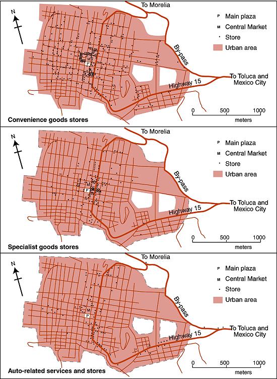
The maps below show the distribution in 1980 of three distinct types of commercial establishments in the mid-sized city of Zitácuaro in Michoacán.

Map of retail activities in Zitácuaro, Michoacán

Retail activities in Zitácuaro, Michoacán. Color version of Figure 22.3 of Geo-Mexico: the geography and dynamics of modern Mexico. All rights reserved.

Founded hundreds of years earlier, the city grew spontaneously, almost organically, with little planning; its population by 1980 was 100,000. Cars were not a necessity. The residents of Zitácuaro did not have to walk far to purchase their basic daily shopping needs. Convenience stores (top map) existed in every  neighborhood. Many (145 out of 393) were genuine “corner stores”, strategically located at street intersections. On average, each convenience store served about  250 residents.

More specialist stores (middle map), selling so-called “shopping goods” such as clothes and furniture, had a very different distribution. A few were located in  residential areas, but most were concentrated in the heavily trafficked central area of the city, in the narrow streets close to the main plaza or zócalo, west of the main highway.

By 1980, a bypass had been opened enabling through traffic to avoid the main congested highway through the center of the city. However, the distribution of specialist stores does not appear to show any close connection to either the old highway or the new bypass.

This contrasts with the distribution of stores connected to auto services (gas stations, auto parts, tire repairs, mechanics) where the preferred locations in 1980 were close to the main highway (bottom map). In the succeeding years, this distribution has changed somewhat. Many of these services have now relocated to the by-pass to better serve the passing traffic.

This post is an excerpt from Geo-Mexico: the geography and dynamics of modern Mexico. Chapters 21 and 22 of Geo-Mexico analyze Mexico’s 500-year transition to an urban society and the internal geography of Mexico’s cities. Chapter 23 looks at urban issues, problems and trends. To preview more parts of the book, click here and use amazon.com’s “Look Inside” feature. Buy your copy today!

The thorny issues of plant and animal trafficking and biopiracy in Mexico

 Excerpts from Geo-Mexico  Comments Off on The thorny issues of plant and animal trafficking and biopiracy in Mexico
Oct 282010
 

In several previous posts we examined the megadiversity of Mexico’s ecosystems which include more than 10% of all the world’s living species.

Mexico’s biodiversity is under pressure from several quarters.

Plant and animal trafficking

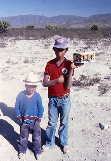
Selling wildlife by the roadside in Chihuahua state

Roadside entrepreneurs sell wildlife in Chihuahua state. Photo: Tony Burton; all rights reserved.

Plant and animal trafficking is the country’s third largest criminal activity after illegal drugs and arms smuggling. Favored items include cacti, live birds (some species sell for upwards of $100,000), spider monkeys, sea turtles, snakes and jaguars. Mexico is one of 175 nations that have signed the Convention on International Trade in Endangered Species (CITES) but this has had no discernible effect on the trafficking of flora and fauna.

Biopiracy

Mexico’s megadiversity presents both opportunities, for activities such as ecotourism, as well as challenges such as preventing biopiracy. In its simplest form, biopiracy occurs whenever a bioprospector takes biological material from a place and then acquires a patent or intellectual property rights on it, or one of its constituents, elsewhere. The best documented example of biopiracy in Mexico occurred in 1999 when a US patent was granted to Colorado-based company Pod-ners for the exclusive right to market Enola beans bred from Mexican yellow beans bought only five years previously. Mexico’s bean export business collapsed overnight as shippers were accused of patent infringement. Yellow bean production in Sinaloa fell by 62% in three years.

Mexican growers subsequently proved that the yellow beans they had been breeding for decades are genetically identical to Enola beans but the damage had been done. Subsequently, the patent was challenged by the International Center for Tropical Agriculture. In 2008 the US patent office finally reversed its decision and rejected any patent claims on yellow beans. While this case of biopiracy was thwarted, acts of biopiracy, by their very nature, are usually clandestine and there are certain to be other instances in the future.

This is an excerpt from chapter 30 of Geo-Mexico: the geography and dynamics of modern Mexico. Buy your copy today, and learn more about Mexico’s fascinating geography. The more knowledge you acquire, the more pleasure you will derive from your next trip to Mexico!

The disposal of solid wastes in Mexico

 Excerpts from Geo-Mexico  Comments Off on The disposal of solid wastes in Mexico
Oct 252010
 

The disposal of solid wastes has become a serious problem almost everywhere in the world. In general the more affluent a society, the more solid waste it generates. Technologically-advanced civilizations tend to produce many wastes that are not biodegradable, further complicating the disposal problem. With each succeeding decade, Mexico faces greater and more complex challenges in managing its solid waste.

Garbage recycling at Oaxaca City dump

Garbage recycling at Oaxaca City dump. Photo: Conrad Fox, World Vision Report

In terms of weight, the vast majority of solid waste is produced by the agricultural sector. Fortunately most of this waste in readily biodegradable and is produced in areas of relatively low population density. However, agricultural wastes in the form of fertilizers and pesticides which are carried into steams and rivers have significant impacts on water quality. Animal wastes from concentrated feed lot operations are another major concern particularly because they are often located relatively close to densely populated areas.

Municipal solid waste includes waste from most commercial establishments and many small industrial operations. Mexico’s urban waste exceeds 36 million tons a year, three times the equivalent figure for Canada. Many municipalities in Mexico have initiated recycling programs, primarily focused on aluminum, glass, certain plastics and paper. However, in 2008 only 3.3% of Mexico’s total urban waste was recycled. Waste from larger towns and cities, about half of the total, is deposited in properly operated sanitary landfills. Waste from smaller communities often ends up in dumps, two thirds of which are uncontrolled.

The management (treatment or recycling) of hazardous wastes has improved greatly in recent years, particularly in the states of Nuevo León, Tamaulipas, Mexico, Tabasco and the Federal District. About half of all hazardous waste originates either in the state of Chihuahua (31% of the total) or in Mexico City (17%).

See also:

This is an excerpt from chapter 30 of Geo-Mexico: the geography and dynamics of modern Mexico. Buy your copy today, and learn more about Mexico’s fascinating geography.

Oct 082010
 

This year marks the centenary of the start of the Mexican Revolution. One of the fundamental causes of the Mexico Revolution in 1910, though by no means the only one, was the demand by landless campesinos (peasant farmers) for access to the means to control their own supplies of food. Revolutionary leaders called for the expropriation of the large estates or haciendas, which had been the principal means of agricultural production since colonial times, and the redistribution of land among the rural poor. A law governing this radical change in the land tenure system came into force in 1917 and the process has continued, albeit sporadically, into modern times.

About half of all cultivated land in Mexico was converted from large estates into ejidos, a form of collective farming. In most ejidos, each individual ejidatario has the rights to use between 4 and 20 hectares (10-50 acres) of land, depending on soil quality and whether or not it is irrigated. In addition, members of the ejido share collective rights over the use of local pasture and woodland. The system is similar to that in place in Aztec times. The maximum area of land that hacienda owners were allowed to keep varied with its potential use, from 100 hectares in the case of irrigated arable land to 300 hectares for land without irrigation.

By 1970 land redistribution had been more or less completed. Even so, most farming land still remained in the hands of a very small minority of farmers. Only 1% of farms were larger than 5000 hectares (12,355 acres) but between them they shared 47% of all farm land. Meanwhile, 66% of farms were smaller than 10 hectares (25 acres) yet they shared only 2% of all farm land. The ejido system did not produce the anticipated increase in food production or food security. Hacienda owners opted to keep their most productive land, meaning that many ejidos had to work land that was marginal at best. Many ejidatarios saw no need to pursue profits provided their families were well fed.

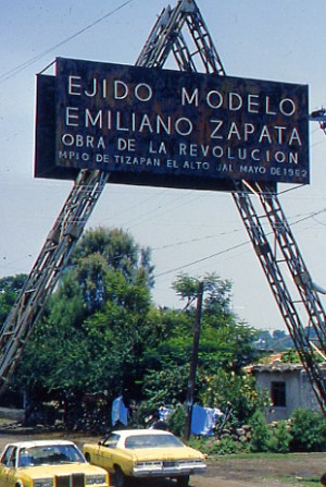
Entrance to Ejido Modelo Emiliano Zapata, Jalisco. Photo: Tony Burton

Many individual plots were too small for mechanization, and nutrients were rapidly depleted through constant use. Collective ownership of the land meant that individuals could offer no collateral for improvement loans. Many campesinos abandoned their ejidos and sought their futures elsewhere, migrating either to the big cities, for their range of manufacturing and service jobs, or to the USA. A sizable proportion of ejido land is no longer economically productive, but only in the 1990s was any mechanism put in place for ejido lands to be sold and revert back to private status.

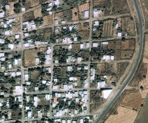
The photo shows the entrance to the “model ejido” of Emiliano Zapata, near Tizapán el Alto, Jalisco, on the southern shore of Lake Chapala. (nb. Despite the claims of Google Earth that this ejido is in the state of Michoacán, it is definitely in Jalisco, though relatively close to the state border.) The ejido has a population of about 2500. The Google Earth image clearly shows a dispersed rural settlement pattern, quite unlike the more usual nucleated villages of rural areas in most of Mexico. Each individual ejitario has a small plot of land around his/her house, and also has a share in the communal land beyond the perimeter of the settlement.

Google Earth image of part of Ejido Modelo Emiliano Zapata, Jalisco

This is an excerpt from chapter 15 of Geo-Mexico: the geography and dynamics of modern Mexico. Buy your copy today, and learn more about Mexico’s fascinating geography. Additional knowledge will greatly enhance the pleasures you derive during your next trip to Mexico.

Sep 152010
 

The remote Copper Canyon region in northern Mexico is the home of 50,000 Tarahumara Indians who have preserved much of their distinctive culture (language, dress, customs, beliefs) into this century, partly because of their extreme remoteness. Many live untouched by the trappings of modern civilization, moving between caves just below the canyon rim and warmer, winter shelters at lower altitude near the Urique River.

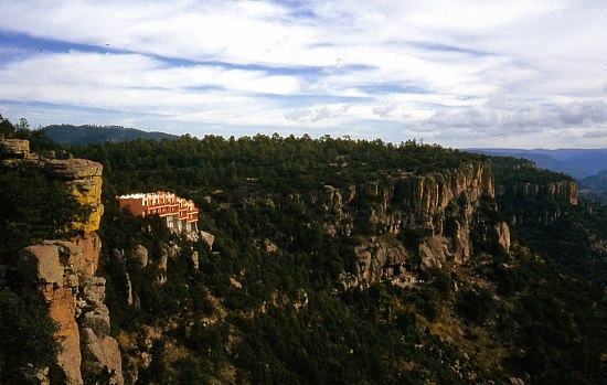
Modern hotels are encroaching on the Copper Canyon

Modern hotels are encroaching on the Copper Canyon, and changing the views in this wilderness region. Photo: Tony Burton; all rights reserved.

Their radically different lifestyle and extreme isolation beg many questions. Their ancestral homelands are already being invaded by marijuana-growers and trampled on by outside developers who have very different notions of property rights and very different customs.

Questions to think about:

  • Are the Tarahumara Indians really in any position to make informed decisions about their future?
  • Should we leave them entirely alone and let them decide entirely for themselves?
  • Should we offer education about what we would consider the benefits of the modern world?
  • Should we improve their access to health services and hospitals?
  • Should we encourage them to acquire computers and internet access?
  • Might these progressive elements destroy their existing lifestyle, break down their social and political structures and ultimately wipe them out?
  • What do YOU think? Now, imagine you were a Tarahumara Indian – would you think the same?
  • Who should decide the future of this region?

Previous Geo-Mexico posts related to the Copper Canyon:

Chapter 10 of Geo-Mexico: the geography and dynamics of modern Mexico is devoted to Mexico’s indigenous peoples, including the Tarahumara Indians. If you have enjoyed this post, please suggest to your local library that they purchase a copy to enhance their collection.

Mexico’s Copper Canyon train is one of the world’s great railway trips

 Excerpts from Geo-Mexico, Other  Comments Off on Mexico’s Copper Canyon train is one of the world’s great railway trips
Sep 022010
 

The Copper Canyon region is one of the most remote parts of Mexico. This remoteness helps to explain why the area is the home of about 50,000 Tarahumara Indians, and how they have managed to preserve much of their highly distinctive culture to this day.

The Copper Canyon railroad line, “the most dramatic train ride in the Western Hemisphere” (Reader’s Digest), begins in Ojinaga and continues, via Chihuahua, to Los Mochis and Topolobampo. The railroad was started in the 1870s to enable produce grown in southern Texas to be exported via a Pacific port. Simultaneously, the twin settlements of Los Mochis and its port Topolobampo were developed on the other side of the Western Sierra Madre. The railroad project floundered and successive attempts to complete it all failed. Some innovative engineering finally led to the line being completed in 1961. Total cost? Over $100 million.

The highlights include a 360-degree loop at El Lazo (km 585 from Ojinaga), one of only three comparable examples anywhere in North America), and a 180-degree turn inside a tunnel near Temoris at km 708. The line crosses the Continental Divide three times, reaches a maximum height of 2400 m (at km 583) and skirts the rim of the Copper Canyon. Between Chihuahua and Los Mochis, there are 37 bridges (totaling 3.6 km) and 86 tunnels (totaling 17.2 km). Almost all passenger rail services in Mexico ended in the 1990s but daily services continue along this line, mainly for tourists.

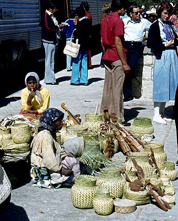
Tarahumara Indians wait for a sale at Divisadero, the station on the rim

Tarahumara Indians wait for a sale at Divisadero, the station on the canyon rim. Photo: Tony Burton; all rights reserved.

Almost all trains stop for a few minutes at Divisadero, a station set right on the rim of the canyon, with a lookout offering a magnificent panoramic view. Shy Tarahumara women and children sit quietly, weaving pine-needle baskets (see photo) and hoping for a sale. Many of them speak very little Spanish apart from the numbers; on the other hand, how many tourists speak even one word of the Tarahumara language? Thirty years ago, most articles sold by the women were items similar to ones they would use everyday themselves in their daily tasks. Sadly, many of the articles sold today are made specifically for the tourist trade.

Unlike the railway, Los Mochis and Topolobampo both soon flourished. Topolobampo was started by US engineer Albert Kimsey Owen who chose this previously unsettled area for a socialist colony based on sugar-cane production, and as the terminus for the railway. Topolobampo has one of Mexico’s finest natural harbors, a drowned river valley or ria, which affords a safe haven in the event of storms. Los Mochis was officially founded in 1893 by a second American, Benjamin Johnston, who built a sugar factory there.

Los Mochis became especially important in the second half of the twentieth century as a major commercial center, marketing much of the produce grown on the vast El Fuerte irrigation scheme. Much of this produce is still exported to the USA via the famous Copper Canyon railway. Los Mochis and Topolobampo are unusual—there are few other examples of such “new towns”, with no colonial or pre-Hispanic antecedents, anywhere else in Mexico.

Previous Geo-Mexico posts related to the Copper Canyon:

External links of interest:

Chapter 10 of Geo-Mexico: the geography and dynamics of modern Mexico is devoted to Mexico’s indigenous peoples, including the Tarahumara Indians. If you have enjoyed this post, please suggest to your local library that they purchase a copy to enhance their collection.

Mexico’s Copper Canyon is one of the world’s most amazing natural wonders

 Excerpts from Geo-Mexico, Updates to Geo-Mexico  Comments Off on Mexico’s Copper Canyon is one of the world’s most amazing natural wonders
Aug 282010
 

The Copper Canyon, one of Mexico’s most amazing natural wonders The rugged ranges of the Western Sierra Madre in the state of Chihuahua conceal several massive canyons, giving rise to incomparable scenery. The Copper Canyon (Cañon del Cobre) region is the collective name given to this branching network of canyons, larger in many respects (see table) than the USA’s Grand Canyon.

How does Mexico’s Copper Canyon compare to the US Grand Canyon?

Urique CanyonsUS Grand Canyon
Total length of rivers (km)540446
Depth (m)1250–18701480
Altitude of rim (m above sea level)2250–25402000–2760
Maximum width (km)415

Strictly speaking, the name Copper Canyon refers only to one small part of the extensive network of canyons which is more properly called by geographers the Urique Canyon system. As the table shows, the Urique Canyons are longer, deeper and narrower than their US rival.

Mexico's Copper Canyon

How was the Copper Canyon formed?

According to a local Tarahumara Indian legend, the canyons were formed when “a giant walked around and the ground cracked.” Geologists believe that a sequence of volcanic rocks varying in age from 30 to 135 million years were slowly uplifted to an average elevation of 2275 m (7500 ft) and then dissected by pre-existing rivers.

These antecedent rivers retained their courses, cutting down over 1400 m into the plateau surface, forming deep canyons and dividing the former continuous plateau into separate giant blocks. Centuries of erosion by the Urique river and its tributaries have resulted in the present-day landscape of structurally-guided plateau remnants, termed mesas, buttes and pinnacles, depending on their size.

Over half a million natives of the state of Puebla live in New York City

 Excerpts from Geo-Mexico  Comments Off on Over half a million natives of the state of Puebla live in New York City
Aug 252010
 

The New York City area is now home to over half a million poblanos, natives of the Mexican state of Puebla. A 2005 Smithsonian article by Jonathan Kandell (available here as a pdf file) takes a close look at their expectations and aspirations. Most started as undocumented workers, but many have gained legal status through the 1986 Immigration Reform and Control Act (ICRA) or a variety of other means.

The story of Ricardo and Aldea is just one example. They got to New York by crossing the 49o C (120o F) Sonoran Desert in the summer of 2003. They work 70-hour weeks for less than the minimum wage. She will pay for her month long trip back to Puebla by serving as a courier, or paquetera, a person who carries clothing, electronics, and other gifts from immigrants to their families.

Getting back and forth across the border without proper documents is more difficult than it used to be, but is not a significant problem. Most rely on trusted polleros, often called coyotes, who provide border crossing service for fees ranging from a few hundred dollars for just crossing the border to a few thousand dollars for door-to-door service.

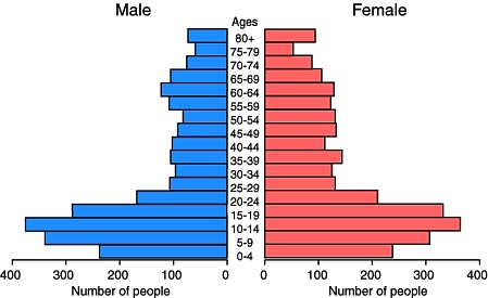
Population pyramid for Piaxtla, 2000.

Population pyramid for Piaxtla, 2000. How does this pyramid reflect out-migration?

Migration has had a profound impact on villages in Puebla, such as Piaxtla. Most of the 1600 current residents of Piaxtla are either children or elderly (see population pyramid). The mayor claims that “maybe three out of four of my constituents live in New York”. The hundreds of millions of dollars send back each year are having a dramatic effect on rural communities in Puebla. Forty years ago, virtually all the houses were made of palm-thatch adobe. Now they are mostly brick and concrete. Many are topped with satellite dishes.

The towns also have new restaurants, taxis, video arcades, cybercafes, and newly paved streets, all made possible from remittances. Ironically, the towns are sparsely populated and many of the new houses are empty because their owners are working in New York.

Most youth consider the prospect of migration. Few think about careers in Mexico or becoming artisans and continuing Puebla’s long tradition of ceramics, woodworking and weaving. Teenagers show little interest in corn farming, the traditional mainstay of the local economy. In short, migrating to jobs in New York has become the norm.

Somewhat similar migration channels link:

For previous posts about remittances, the funds sent home by migrant workers, see:

Migration between Mexico and the USA is the focus of chapter 25 of Geo-Mexico: the geography and dynamics of modern Mexico. Ask your library to buy a copy of this handy reference guide to all aspects of Mexico’s geography today! Better yet, order your own copy…

The revitalization of Mexico City’s historic downtown core.

 Excerpts from Geo-Mexico  Comments Off on The revitalization of Mexico City’s historic downtown core.
Aug 172010
 

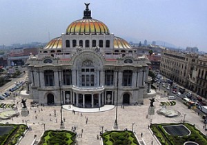
The Historic Center of Mexico City was originally founded in 1524 atop the Aztec capital of Tenochititlan. The Historic Center declined considerably during the 20th century. The government froze rents in the 1940s and they stayed frozen until 1998. With constant inflation, the real price of rents declined to almost nothing.

Bellas Artes opera house, Mexico CityWithout meaningful rental incomes, landlords abandoned or stopped maintaining their properties. Buildings and neighborhoods decayed. Once-fancy communities became slums. Many wealthy and middle class residents as well as commercial establishments moved out to suburbs. The National University (UNAM) moved to a new purpose-built campus in the south.

The tragic earthquakes in September 1985, the first measuring 8.1 on the Richter scale, hit many badly maintained downtown areas particularly hard. More and more residential buildings were abandoned as insecurity, pollution and decay set in, aided and abetted by the sinking ground levels due to aquifer depletion.

At the start of the 21st century, a government-private sector Historic Center Trust was formed to buy and systematically rehabilitate dozens of centuries-old buildings and breathe new life into the city center. Investment in the revitalization effort was over $500 million and has created 15,000 new jobs.

Drainage and water systems were replaced. Electric and telephone cables were buried below ground. The facades of more than 500 buildings on 13 streets were carefully restored. Streets were repaved and pedestrianized. Plazas came back to life; new museums sprung up; street vendors were relocated. Cafes and restaurants opened, giving new focal points for residents and tourists alike.

If you have enjoyed this brief excerpt from chapter 23 of Geo-Mexico: the geography and dynamics of modern Mexico please consider purchasing your own copy of the book. Chapters 21 and 22 analyze Mexico’s 500-year transition to an urban society and the internal geography of Mexico’s cities. Chapter 23 looks at urban issues, problems and trends. To preview more parts of the book, click here and use amazon.com’s “Look Inside” feature

Fascinating new book about the Colorado River

 Books and resources, Excerpts from Geo-Mexico, Maps  Comments Off on Fascinating new book about the Colorado River
Aug 162010
 

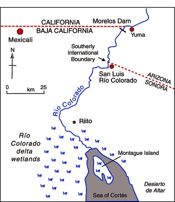
The Río Colorado formed a vast delta in the otherwise arid Sonoran desert in northern Mexico where it enters the Sea of Cortés (Gulf of California, see map.) The delta wetlands created ideal conditions for a rich variety of wildlife. The river enters Mexico at the Southerly International Boundary where a gauging station records the river’s discharge. This river is one of the most altered river systems in the world.

Map of the Colorado delta

Map of the River Colorado delta. All rights reserved.

The amount of water reaching Mexico has declined dramatically as a result of the Hoover and Glen Canyon dams and other diversions of Colorado River water in the USA. The few years of higher flows in the 1980s coincide with flood releases from US dams when they had been filled by heavy rains.

The river’s drastically reduced annual discharge violates a 1944 treaty under which the USA guaranteed that at least 1750 million cubic meters would enter Mexico each year via the Morelos diversionary dam in the Mexicali Valley. The Río Colorado wetlands have been reduced to about 5% of their original extent, and the potential water supply for the rapidly-growing urban centers of Mexicali, Tijuana, Tecate and Rosarito has been compromised.

The map and description above come from Geo-Mexico: the geography and dynamics of modern Mexico.

If you are interested in learning more about this river, a great place to start is the recently published book about the Colorado River called Running Dry: A Journey From Source to Sea Down the Colorado River (Jonathan Waterman; National Geographic Books, 2010). Waterman hiked and paddled the length of the river from the Rocky Mountain National Park to its delta in the state of Baja California, Mexico.

For excerpts from the book, see Running Dry on the Colorado and Mighty Colorado River dribbles through Mexico.

Peter McBride, a photographer, accompanied Waterman on his two year trek. His evocative photographs will appear in the book The Colorado River: Flowing Through Conflict (Westcliffe Publishers), due out in September. See Down the Colorado (slideshow) for some examples of his Colorado River photos.

Rivers, reservoirs and water-related issues are discussed in chapters 6 and 7 of Geo-Mexico: the geography and dynamics of modern Mexico. Ask your library to buy a copy of this handy reference guide to all aspects of Mexico’s geography today! Better yet, order your own copy…

Geo-Mexico is reader-supported. Purchases made via links on our site may, at no cost to you, earn us an affiliate commission. Learn more.

Highway improvement revolutionized the economy of Chilapa, Guerrero

 Excerpts from Geo-Mexico  Comments Off on Highway improvement revolutionized the economy of Chilapa, Guerrero
Aug 112010
 

Transportation improvements can have profound impacts on the areas they serve.  A major highway improvement in the 1970s revolutionized the rural economy of Chilapa, a small town about 40 km east of Chilpancingo, the capital of Guerrero.  Prior to 1970, the area was essentially self-sufficient, as it had been for hundreds of years.  All the corn and most of food consumed in Chilapa came via pack animals from farms within 12 km of the town.  It did produce some cotton shawls (rebozos) and later woven palm goods which were sold to obtain money for salt, iron, cotton, matches and other essentials not produced locally.

In the 1970s, the old narrow windy road to Chilpancingo was upgraded to a national highway (No. 92), straightened and paved, dramatically reducing transport time and costs.  This had a dramatic impact on Chilapa.  Corn and other goods from the rest of Mexico and abroad poured into the area, leading to significantly lower prices. The local farmers could not compete; many stopped farming altogether.  Some started commuting by bus to low paying jobs in Chilpancingo.  When subsidies became available for chemical fertilizers and hybrid corn, farmers began producing high quality corn that was sold outside the area. Chilapa continued importing cheap, low quality corn for local consumption. The new road completely changed the economy of the area around Chilapa, brought it farther into the national economy and improved its standard of living. There are thousands of communities in Mexico that are not yet served by paved roads and are essentially as self-sufficient and poor as Chilapa was before the 1970s.  In addition, there are hundreds of other communities not reached even by dirt roads; they are even poorer and more self-sufficient.

Note: the main source for material about Chilapa is Kyle, C. 1997 “Transport and Communication” 1910-96, in Werner, M.S. (ed) Encyclopedia of Mexico: History, Society & Culture. Chicago, Fitzroy Dearborn.

The development of transportation systems in Mexico is the focus of chapter 17 of Geo-Mexico: the geography and dynamics of modern Mexico.


Aug 092010
 

The Bracero program started in 1942 as a way to alleviate the severe US labor shortage during the second world war. It gave selected Mexicans renewable six-month visas to work temporarily on US farms. Most workers came from Michoacán, Jalisco, and Guanajuato. Many US farmers became very dependent on the productive and relatively cheap Mexican labor.

Los BracerosMany Mexican workers also entered the USA without visas and easily found well-paying jobs in agriculture and other sectors. Numerous US industries began to depend on these undocumented workers. The US government and public accepted this reality; they were preoccupied fighting a war.

The Bracero Program was considered such a success that it continued long after the war ended. It was finally repealed in 1964, largely as a result of pressure from labor unions, who felt it held down farm wages, and Latino groups which felt it impeded the upward mobility of US Hispanics.

An estimated 4.5 million Mexican Bracero workers legally entered the USA between 1942 and 1964. At its height in the late 1950s, more than 500,000 workers migrated each year. Most were temporary migrants who returned to Mexico within a year. Migration to the USA became an integral part of the socio-economic fabric of many rural communities in west central Mexico. In many cases, families and villages became trans-national. Workers divided their time between work in the USA and their families in Mexico.

The Bracero program set the stage for the continued high volume of Mexican labor migration to the USA. Closure of the Bracero program had minimal impact on migration, which continued to grow steadily through the 1960’s and 1970’s before accelerating rapidly after 1980.

For more information about the Bracero program: The Bracero Archive

For previous posts about remittances, the funds sent home by migrant workers, see:

Migration between Mexico and the USA is the focus of chapter 25 of Geo-Mexico: the geography and dynamics of modern Mexico. Ask your library to buy a copy of this handy reference guide to all aspects of Mexico’s geography today! Better yet, order your own copy…

Aug 062010
 

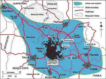
The rapid spatial expansion of Mexico City is not slowing down in the 21st century but accelerating. The main stimulus of this sprawl is income growth, which leads to widespread ownership of private automobiles and the desire of Mexican families to own homes. The number of automobiles in Metropolitan Mexico City (ZMCM) is approaching 10 million, almost double the number in 2000. Most households have access to a private car, many have several cars. Automobiles are responsible for nearly half of all trips. While the 2008–2009 economic downturn dramatically reduced new car purchases, the market has picked up significantly in 2010.

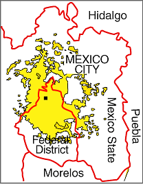
Map of Mexico City urban system

Map of Mexico City urban system. Click to enlarge. All rights reserved.

New suburban residential developments for all income levels now stretch up to 40 km from the Zócalo (the main plaza in Mexico City’s center).  Some developers sell undeveloped lots; others build family homes. Most of these new developments are in gated communities and are focused on car-owning buyers.

A case can be made that Mexico City is beginning to merge with surrounding urban areas (see map) into a “super city” or megalopolis, with a total population of about 30 million.

The eastern border of the Toluca Metropolitan Area (population 1.6 million) is the Federal District. The Cuernavaca urban area (population 788,000) is only about 20 minutes south by toll road. The western edge of Metropolitan Puebla-Tlaxcala (population 2.1 million) is only about 30 minutes from the eastern edge of Greater Mexico City. Pachuca (population 278,000) is only about 30 minutes north.

A megalopolis is one possible future scenario for Mexico City.

If you have enjoyed this brief excerpt from chapter 23 of Geo-Mexico: the geography and dynamics of modern Mexico please consider purchasing your own copy of the book. Chapters 21 and 22 analyze Mexico’s 500-year transition to an urban society and the internal geography of Mexico’s cities. Chapter 23 looks at urban issues, problems and trends. To preview more parts of the book, click here and use amazon.com’s “Look Inside” feature.

El Camino Real or Royal Road, the spine of the colonial road system in New Spain (Mexico)

 Excerpts from Geo-Mexico  Comments Off on El Camino Real or Royal Road, the spine of the colonial road system in New Spain (Mexico)
Aug 042010
 

By the start of the 16th century, the Aztec Empire had a well developed system of “roads”.  However the Aztecs had neither wheels nor beasts of burden to transport themselves or their goods.  Obviously this limited transportation to the speed, range and endurance of foot power.  Their system of roads was essentially a system of foot trails.

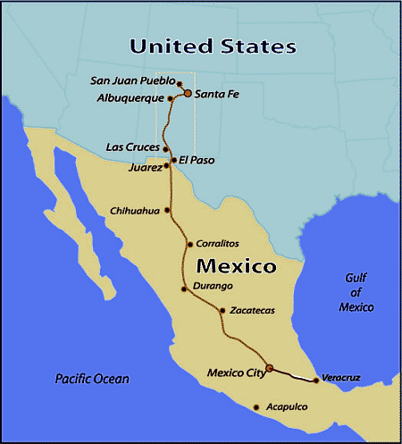
Map of Camino RealThe Spanish conquistadors found the Aztec roads completely unsuitable for horse traffic and animal-drawn carts. They were forced to undertake expensive re-routing, flattening, widening, and upgrading.  In 1550, they started construction of the first section of El Camino Real (the royal highway) linking Mexico City with Spain through the port of Veracruz.  The opening of this new road greatly facilitated communication and the transfer of Aztec gold to Spain, and Spanish goods to Mexico’s interior. To counter the threat of bandits, the road was constantly patrolled by soldiers.

Towns along this route gained new importance. Puebla become the second largest and most important city in New Spain, a position it was to hold for 300 years. In the late 1550s, the road was extended north to Zacatecas, to facilitate transporting gold and silver from that area back to Mexico City and then on to Spain.

El Camino Real was later extended to other important cities and mining districts.  By 1600 it reached as far north as Chihuahua and was later extended to Santa Fe (in what is now New Mexico).  Many other roads were added to the system to facilitate administration, communication and economic exploitation.

In 1565, the Spanish decided it was safer to ship Asian goods from their colony in the Philippines back to Spain by crossing the Pacific, transshipping the cargo across the breadth of Mexico, and then sailing from Veracruz to Spain. To support this, the El Camino Real was expanded to link Mexico City to Acapulco. This section was only serviceable for pack mules; a road suitable for wheeled vehicles was not completed until well into the 20th century.

For 250 years, Spanish galleons carried Mexican silver to Manila, and returned with spices, silk, porcelain, lacquer ware, and other exotic oriental goods destined for Spain.

The development of Mexico’s transportation system is discussed in chapter 17 of Geo-Mexico: the geography and dynamics of modern Mexico. Ask your library to buy a copy of this handy reference guide to all aspects of Mexico’s geography today! Better yet, order your own copy…

Jul 272010
 

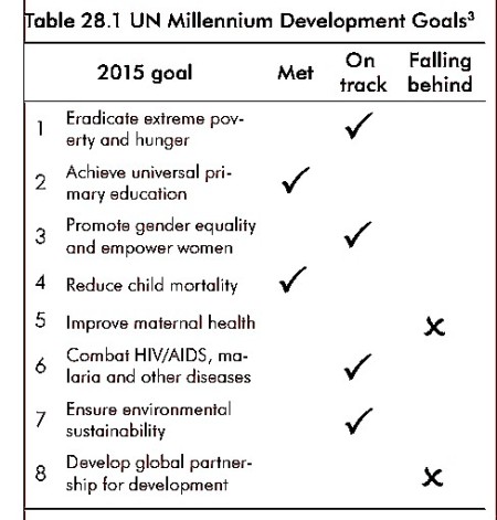
More than 190 countries signed up to the UN Millennium Development Goals (MDGs), agreed in 2000. Mexico is well on its way to meeting most of the eight goals (see table below).

UN Millennium Development Goals

Please refer to “Geo-Mexico: the geography and dynamics of modern Mexico” if you copy this resource

Each goal has numerous specific targets. Mexico met one of the key targets — a 50% reduction in the proportion of children suffering from hunger (under-nutrition) between 1990 and 2015 — with several years to spare. It has also met its child mortality target.

Specific targets that Mexico has not yet reached include:

  • an increase in the proportion of GDP that corresponds to the poorest 20% of the population (part of goal 1)
  • an increase in the number of women in government (goal 3)
  • a further decrease in maternal mortality (goal 5);
  • an increase in forested area (goal 7)
  • an improved employment rate for young people aged 15–24 (goal 8)

In future posts, we will take a look at some of these specific goals and examine Mexico’s progress towards meeting them in more detail.

Geo-Mexico: the geography and dynamics of modern Mexico is an outstanding new resource for courses in geography, economics, sociology and development studies, designed to be relevant to both general and academic readers. It provides an up-to-date account of Mexico suitable for students taking initial university or college courses related to geography, economics and Mexican or Latin American studies.  Buy your copy today!

Education professionals are invited to contact us if they would like to request a review copy. In addition, the entire book is searchable via the “Look Inside” feature of amazon.com

Jul 232010
 

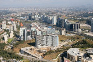
Santa Fe, in upscale western Mexico City is one example of the many new developments being built on the urban periphery in Mexico.

Santa Fe, a subsidiary CBD in Mexico City

Santa Fe has become a subsidiary CBD in Mexico City. Photo: Oscar Ruiz

The plan for the Santa Fe complex called for private sector financed office towers, a gigantic retail mall, high income housing, park areas, as well as schools and universities. Construction was halted briefly by the 1994–95 economic crises, but soon resumed at full speed. Today Santa Fe has numerous skyscraping office towers, over one eighth of the Federal District’s total office space, about 70,000 employees, four universities with 13,500 students, over 4300 residents, and one of the largest retail malls in Latin America.

Santa Fe is essentially an island that is only accessible by private car; public transport is relatively limited.

Unfortunately, it has not fully lived up to expectations. The preponderance of cars, mostly with a driver and no passengers, has led to severe traffic jams. Perhaps related to this, the vacancy rate of office space is about 25%. Furthermore, even with eight million visitors a year, the gigantic Santa Fe shopping mall is not as heavily utilized as competing malls in the area.

How many of the shoppers in Santa Fe mall or students attending classes realize that they are on top of what was once one of the biggest garbage dumps in Mexico City? Prior to its development into high-end real estate, much of this area had been quarried for sand, and the resulting holes  used as a landfill site for household and industrial waste. Some of the structural problems reported in buildings in Santa Fe may well be due to the settling of these less than savory foundations.

(Our sincere thanks to Fatimah Araneta for improving this account)

If you have enjoyed this brief excerpt from chapter 23  of Geo-Mexico: the geography and dynamics of modern Mexico please consider purchasing your own copy of the book. Chapters 21 and 22 analyze Mexico’s 500-year transition to an urban society and the internal geography of Mexico’s cities. Chapter 23 looks at urban issues, problems and trends. To preview more parts of the book, click here and use amazon’s “Look Inside” feature.

Meandering river leads to border dispute

 Excerpts from Geo-Mexico  Comments Off on Meandering river leads to border dispute
Jul 222010
 

The 1848 Treaty of Guadalupe Hidalgo, signed after the Mexican-American War, ceded over half of Mexico’s territory to the USA. A few years later, under the 1853 Gadsden Purchase (Treaty of La Mesilla), northern portions of Sonora and Chihuahua were transferred to the USA. This established the current border between the two countries.

The end to a border dispute caused by a meandering river

The end to a border dispute caused by a meandering river

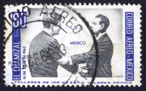
Minor disputes have occurred since due to the migrating meanders of the Río Bravo (Río Grande) which forms much of the border between Mexico and the USA. Flooding during the early 1860s moved the Río Bravo channel south, shifting an area of about 2.6 square kilometers (1 square mile) from Ciudad Juárez in Mexico to El Paso in the USA. Both countries claimed the area, giving rise to the El Chamizal dispute.

This dispute went to international arbitration in 1911 and was only finally resolved in 1963 with the ratification of the Chamizal Treaty. In 1963, President Adolfo López Mateos met his US counterpart John F. Kennedy on the border formalizing the end of the Chamizal dispute.

The USA and Mexico shared the costs of rechanelling the river in an effort to prevent further migrating of its meanders. The concrete channel is about 50 meters (170 feet) wide and almost 5 meters (15 feet) deep. As we saw in July 2010, with the flooding following Hurricane Alex, even this size of channel is sometimes unable to contain the full flow of the river.

A similar dispute, the Ojinaga Cut, was resolved in 1970.

In El Paso, the Chamizal National Memorial was established in 1966 as a permanent memorial to commemorate the two nations’ laudable  international cooperation, diplomacy and respect for cultural values in arriving at a mutually acceptable resolution to the conflict.

The changing political frontiers of Mexico are the subject of chapter 12 of Geo-Mexico: the geography and dynamics of modern Mexico. If you have enjoyed this post, please consider purchasing a copy of Geo-Mexico so that you have your own handy reference guide to all aspects of Mexico’s geography.

Mexico’s major dams and reservoirs

 Excerpts from Geo-Mexico  Comments Off on Mexico’s major dams and reservoirs
Jul 192010
 

The functions of dams and reservoirs

Mexico’s dams and reservoirs serve many valuable functions. The first is as a source of hydroelectric power. The amount of power that can be generated is a function of the amount of water streaming through the generators and its pressure, which is related to the height of the dam. Just over half of hydroelectric power is generated by dams on rivers which start in southern mountain ranges and flow into the southern portion of the Gulf of Mexico. Most of the rest comes from dams on rivers along the Pacific coast from the Balsas basin all the way north to Sonora.

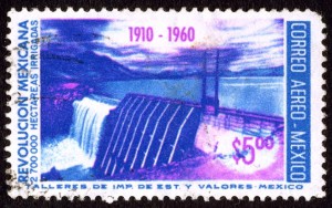
Postage stamp depicting dam and reservoir

The 50th anniversary of the Mexican Revolution: dam, reservoir and water power.

Hydroelectric power has been important since the early part of the twentieth century. Currently about 22% of the electricity  generating capacity is from hydroelectric plants. The largest hydroelectric plants are on the Grijalva River in Chiapas. Other rivers providing significant hydropower are the Balsas, Santiago, Fuerte, Papaloapan and Moctezuma.

Virtually all Mexican dams, except those in the rainiest southern areas, provide water for irrigated agriculture. This is particularly true in arid northern Mexico. Mexico ranks sixth in the world with about 63,000 cubic kilometers of irrigated agriculture. It is well behind India (558,000), China (546,000), the USA (224,000), Pakistan (182,000) and Iran (76,500). About 23% of Mexico’s cultivated area is irrigated, compared to 99.9% in Egypt, 82% in Pakistan, 47% in China and only 12% in the USA.

Dams also protect against floods, especially in the drier northern areas which are very susceptible to floods from rare but torrential downpours.

In addition, dams provide a source of water for urban populations, especially in the largest metropolitan areas.

Finally, the reservoirs behind dams throughout Mexico are an important recreational resource.

On the other hand, the construction of dams can also have negative effects, including habitat loss, the need to relocate existing residents away from the reservoir site, adverse changes in river flows downstream of the dam and sediment accumulation behind the dam which reduces the reservoir’s capacity.

Chapter 6 of Geo-Mexico: the geography and dynamics of modern Mexico is about water availability, rivers and aquifers; it includes several maps including one showing the relative sizes of the main reservoirs.

Absolute distance, relative distance and the vagaries of air travel within Mexico

 Excerpts from Geo-Mexico  Comments Off on Absolute distance, relative distance and the vagaries of air travel within Mexico
Jul 152010
 

In an earlier post we looked at the importance of Mexico City airport in the national network of airports. In this post, we focus our attention more on the network, and much less on any individual airport.

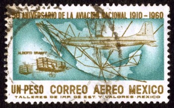
Alberto Braniff's biplane, modern jet and Mexico's airport network in 1960

Air travel greatly distorts the map of Mexico and the world. In terms of travel time on public transport, Mexico City’s airport is closer to Guadalajara, in the state of Jalisco, than to some areas in the Mexico City Metropolitan Area!

Similarly, Guadalajara is closer to Hong Hong by air—21 hours for the 13,000 km—than to some communities only 200 km away in northern Jalisco which require a trek of over 24 hours by bus, taxi and foot.

Business executives fly 2300 km from Tijuana to Mexico City, work for six hours in the city, and fly back the same day. Commuting to the same office takes longer for some Metro area residents who live only 50 km away, but have to contend with traffic congestion.

Air travel, coupled with  familiarity, significantly influences our perceptions of distance. A Guadalajara traveling executive perceives Mexico City as being closer to his home than slum areas within 20 km of his house. Downtown Mexico City seems much closer to a person who commutes there daily from 40 km away than to a neighbor who works locally and only goes downtown once a year.

Transportation systems greatly affect our perception of distance. Depending on connections, air travel is not always the quickest means of transport.

The straight line distance from Mazatlán to Durango is 245 km. The fastest air connection goes through Mexico City and involves flying over 1500 km. It takes seven hours, longer than the inter-city bus! A direct flight would take about 45 minutes. When an expressway connects the two cities, the drive will take less than three hours. Though the straight line distance between them is about the same as that between Querétero and Mexico City, the travel and perceived distance is far greater. This example demonstrates how existing transportation systems affect our perceptions of distance.

“Distance” can also be looked at in terms of costs. In Geo-Mexico, we look at the distinction between absolute distance measured in kilometers and relative distance in terms of cost. We include a graph plotting distance against the price of one-way economy-class direct flights from Mexico City to 28 cities for a random mid-week day in April 2009. The graph shows that there is very little connection between flying distance (or flight times) and ticket price (For statistically inclined readers, rs = 0.14).  Rather than discussing this further here, we suggest you consider purchasing a copy of the book for a more in-depth analysis!

This is an excerpt from chapter 17 of Geo-Mexico: the geography and dynamics of modern Mexico. which discusses transportation systems, including air travel and the national network of airports.

A case study of low-income housing on the urban periphery

 Excerpts from Geo-Mexico  Comments Off on A case study of low-income housing on the urban periphery
Jul 132010
 

A shortage of affordable housing is a persistent problem in large Mexican cities. In response, new, subsidized lower income housing developments are being built on the periphery of Mexico City, Guadalajara, Monterrey, and other metropolitan areas.

Sprawling Mexico City - "El Monstruo"

Sprawling Mexico City - "El Monstruo"

Though most working families can afford the down payment and monthly payments for these subsidized housing units, these expenses leave little extra for food, clothing, utility bills, commuting, and health care. Even these subsidized housing units provide a car parking place because virtually all Mexican families aspire to own their own automobile. The case study which follows, of the Hernández family, illustrates the situation.

Carlos Hernández, his spouse, mother-in-law, and two daughters are happy with their house in a new housing development in Zumpango, about 40 km (25 mi) north of the Mexico City Zócalo. The government-backed mortgage on the tiny (30 square meters – 323 square feet, about the size of a two-car garage), 15,700-dollar, one-bedroom house, is 100 dollars a month. Hernández must spend another $110 a month for his daily five hour commute by colectivo (mini bus), bus, and metro (subway) to his $350 a month maintenance job in the capital. This leaves only $140 a month for all other expenses such as food, utilities, installment payments on furniture and appliances, health care, clothing, schooling, etc. To help make ends meet, his spouse, Edith, runs an informal convenience store out of the front of the house.

The house is very crowded; the kitchen table is brought inside only at mealtimes. Carlos and Edith sleep on a foldout couch in the living room. Edith’s mother, Lucía, has the bedroom and the two daughters take turns sleeping with their parents or grandmother. Hernandez is glad he finally owns a house and no longer has to pay rent. His story is repeated tens of thousands of times as hundreds and hundreds of low-income housing developments are being built on the urban periphery.

If you have enjoyed this brief excerpt from chapter 23  of Geo-Mexico: the geography and dynamics of modern Mexico please consider purchasing your own copy of the book. Chapters 21 and 22 analyze Mexico’s 500-year transition to an urban society and the internal geography of Mexico’s cities. Chapter 23 looks at urban issues, problems and trends. To preview more parts of the book, click here and use amazon’s “Look Inside” feature.

Mexico has 32 states, divided into 2,456 municipalities

 Excerpts from Geo-Mexico, Updates to Geo-Mexico  Comments Off on Mexico has 32 states, divided into 2,456 municipalities
Jul 102010
 

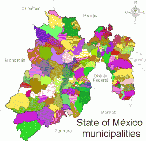
Mexico’s 32 states are divided into municipios (municipalities). There are 2456 municipalities which vary greatly in size and population. For example, the average population of Oaxaca’s 570 municipalities is about 6000 while the average population of Baja California’s five  municipalities is over 500,000. Each municipality elects a new president and local council every three years (except for Coahuila where four-year terms now apply).

State of Mexico municipalitiesMunicipal governments have taxing authority but rely very heavily on financial support from state and federal sources.

Municipalities are responsible for a variety of public services, including water and sewerage; street lighting and maintenance, trash collection and disposal, public safety and traffic, supervision of slaughterhouses, and maintenance of parks, gardens and cemeteries.

Municipalities are also free to assist state and federal governments in the provision of elementary education, emergency fire and medical services, environmental protection and the maintenance of historical landmarks.

Municipalities are therefore akin to  counties in the USA.

Here are a selection of other facts about Mexico’s municipalities:

  • The state with the most municipalities is Oaxaca:  570; at the other extreme, the states of Baja California and Baja California Sur each have only 5 municipalities.
  • Excluding the equivalent territorial divisions of the Federal District (known as delegaciones), the largest municipalities in terms of population are Ecatepec de Morelos (in Mexico State) and Guadalajara (Jalisco). Each is home to about 1.7 million people.
  • The least populated municipality is Santa Magdalena Jicotlán (Oaxaca) which has just 102 inhabitants.
  • Only about 450 municipalities have fewer men than women. The most male-dominated municipality is Aquiles Serdán (Chihuahua) which has 1.6 men for every woman.
  • The most female-dominated municipality is San Miguel Tulancingo (Oaxaca) with 1.5 women for every man.
  • The municipality of Tulum (Quintana Roo) is one of the youngest in the country; its first council was elected in 2009.
  • The most crowded municipality in terms of people per dwelling is San Simón Zahuatlán (Oaxaca):  9.1 persons per household. The national average is 4.2. The least crowded municipality is  Santiago Nejapilla (Oaxaca) where the average occupancy is 2.7 per home.
  • The largest municipality in area is Ensenada (Baja California), 53,304 square kilometers; the smallest used to be San Lorenzo Axocomanitla (Tlaxcala), 4.34 square kilometers, but is now Santa Cruz Amilpas (Oaxaca) which is only 1 square kilometer in area.

The 2010 census, carried out in June, will necessitate revising some of these numbers when the results are released in due course.

Jul 082010
 

Mexico City’s inner city slums date from the regime of Porfirio Díaz (1877–1910) which stimulated rapid railroad expansion and industrialization north and northwest of the city center. The industrial zone expanded out along the rail lines into the areas now known as Azcapotzalco and Gustavo A. Madero.

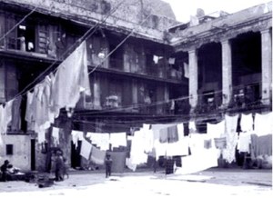
Typical vecindad, Mexico CityWith this expansion, the upper classes sold or abandoned their inner city colonial mansions and moved further west, deliberately avoiding noisy and polluted industrial areas. Their abandoned multi-storied mansions were converted into vecindades, cheap tenements with individual rooms rented to families.

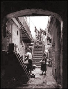
Vecindades, with a shared central court, kitchen and latrines, became Mexico City’s first slums. They encircled the center on the north, east and south; the west side remained upscale. As these eventually became overcrowded, incoming migrants moved into cheap, undesirable housing in the industrial zone or on the urban periphery.

Vecindad, Mexico CityRapid industrialization after World War II brought another massive wave of poor immigrants. They initially headed for the low rent vecindades which had expanded as developers built new tenements using the old vecindades as a model.

Following government-mandated rent control, many investors abandoned the vecindades, depleting an already poor housing stock. Affordable housing emerged as a paramount concern of low-income residents; most were forced into colonias populares either on very steep hillsides or the urban periphery, such as Nezahualcoyotl.

While vecindades are most closely associated with Mexico City, they also emerged in Mexico’s other large cities. About ten percent of Mexico City’s current residents live in vecindades.

Mexico’s cities and towns are analyzed in chapters 21, 22 and 23 of Geo-Mexico: the geography and dynamics of modern Mexico. Buy your copy today!!

The introduction of sheep caused widespread environmental damage in Mexico

 Books and resources, Excerpts from Geo-Mexico  Comments Off on The introduction of sheep caused widespread environmental damage in Mexico
Jul 032010
 

After the conquest, Spanish settlers introduced numerous Old World species into the New World. The most pernicious introductions were human-borne diseases, which led to the rapid and tragic decimation of the indigenous population. However, most of the introductions were deliberate, made with the intention of increasing the diversity of available food and resources. Among the non-native (exotic) plants and animals introduced were sheep, pigs, chickens, goats, cattle, wheat, barley, figs, grapevines, olives, peaches, quinces, pomegranates, cabbages, lettuces and radishes, as well as many flowers.

The environmental impact of all these introductions was enormous. The introduction of sheep to Mexico is a case in point.

In the Old World, wool had been a major item of trade in Spain for several centuries before the New World was settled. The first conquistadors were quick to recognize the potential that the new territories held for large-scale sheep farming.

Cover of A Plague of SheepThe development of sheep farming and its consequences in one area of central Mexico (the Valle de Mezquital in Hidalgo) was analyzed  by Elinor Melville in A Plague of Sheep. Environmental Consequences of the Conquest of Mexico.

Melville divides the development of sheep farming in the Valle of Mezquital into several distinct phases. Sheep farming took off during Phase I (Expansion; 1530-1565). During this phase, the growth in numbers of sheep in the region was so rapid that it caused the enlightened Viceroy, Luis de Velasco, to became concerned that sheep might threaten Indian land rights and food production. Among the regulations introduced to control sheep farming was a ban on grazing animals within close proximity of any Indian village. At first the Indians did not own any grazing animals, and consequently did not fence their fields, which inadvertently encouraged the Spaniards to treat the landscape as common land.

During Phase II (Consolidation of Pastoralism; 1565-1580), the area used for sheep grazing remained fairly stable, but the numbers of sheep (and therefore grazing density) continued to increase. By the mid-1570s, sheep dominated the regional landscape and the Indians also had flocks. One of the consequences of this was environmental deterioration to the point where by the late 1570s, some farmers did not have adequate year-round access to pastures and introduced the practice of seasonal grazing in which they moved their flocks (often numbering tens of thousands of sheep) from their home farm in central Mexico to seasonal pastures near Lake Chapala.

This practice of grazing on harvested fields or temporary pastures was known as agostadero. This term originally applied to summer (agosto=August) grazing in Spain but was adopted in New Spain for “dry season” grazing, between December and March. So important was this annual movement of sheep that provision was made in 1574 for the opening of special sheep lanes or cañadas along the route, notwithstanding the considerable environmental damage done by the large migrating flocks. As flock sizes peaked, more than 200,000 sheep made the annual migration by 1579.

In the words of historian Francois Chevalier:

By 1579, and doubtless before, more than 200,000 sheep from the Querétaro region covered every September the 300 or 400 kilometers to the green meadows of Lake Chapala and the western part of Michoacán; the following May, they would return to their estancias.

The prime dry season pastures were those bordering the flat, marshy swampland at the eastern end of Lake Chapala. The Jiquilpan district alone supported more than 80,000 sheep each year, as the Geographic Account of Xiquilpan and District (1579) makes clear:

More than eighty thousand sheep come from other parts to pasture seasonally on the edge of this village each year; it is very good land for them and they put on weight very well, since there are some saltpeter deposits around the marsh.

By the end of Phase III (The Final Takeover; 1580-1600), most land had been incorporated into the Spanish land tenure system, the Indian population had declined (mainly due to disease) and the sheep population had also dropped dramatically. Contemporary Spanish accounts reveal that this collapse was attributed to a combination of the killing of too many animals for just their hides by Spaniards, an excessive consumption by Indians of lamb and mutton, and by the depletion of sheep flocks by thieves and wild dogs. Melville’s research, however, suggests that the main reason for the decline was actually environmental degradation, brought on by the excessive numbers of sheep at an earlier time.

The entire process is, in Melville’s view, an excellent example of an “ungulate irruption, compounded by human activity.” The introduction of sheep had placed great pressure on the land. Their numbers had risen rapidly, but then crashed as the carrying capacity of the land was exceeded. The carrying capacity had been reduced as (over)grazing permanently changed the local environmental conditions.

By the 1620s, the serious collapse in sheep numbers in the Valle de Mezquital was over; sheep farming never fully recovered. The landscape had been changed for ever.

Sources / Further reading:

  • Acuña, R. (ed) Relaciones geográficas del siglo XVI: Michoacán. Edición de René Acuña. Volume 9 of Relaciones geográficas del siglo XVI. Mexico City: Universidad Nacional Autónoma de México. 1987
  • Chevalier, F. Land and Society in Colonial Mexico. University of California Press. 1963.
  • Melville, Elinor G. K. A plague of Sheep. Environmental consequences of the conquest of Mexico. Cambridge University Press. 1994.

Click here for the original article on MexConnect.

Mexico’s ecosystems and biodiversity are discussed in chapter 5 of Geo-Mexico: the geography and dynamics of modern Mexico. The concept of carrying capacity is analyzed in chapter 19. Buy your copy today, as a useful reference book!
Nezahualcoyotl, an irregular settlement which grew into a monster

 Excerpts from Geo-Mexico, Updates to Geo-Mexico  Comments Off on Nezahualcoyotl, an irregular settlement which grew into a monster
Jul 022010
 

Rapid industrialization north of Mexico City after World War II brought a giant wave of immigrants aggravating a serious shortage of low income housing. With the vecindades (inner city slums) severely overcrowded, the only alternative was “irregular housing” or “colonias populares.” These were developed wherever there was vacant land, mostly in the west and north of the city on the dry former lakebed or on very steep slopes. They all followed a development pattern roughly similar to that of Nezahualcoyotl, the largest and best known colonia popular.

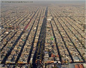
The densely packed housing of Nezahaulcoyotl in all its glory

The densely packed housing of Nezahaulcoyotl in all its glory. Image: imagenesaereasdemexico.com. Follow link at end of post for more Mexico City photos

In the late 1950s, a group of speculators gained de facto possession of roughly 78 square kilometers  (30 square miles) of former lakebed in Nezahualcoyotl just east of the Mexico City airport. They sold nearly 200,000 plots cheaply and on credit, a few dollars down, and a few dollars a month, for 10-20 yrs.

Families bought plots and immediately started to erect shacks. Aside from electricity, which was provided by the national utility, the plots initially lacked basic services such as potable water, sewerage, flood drainage, pavement, schools, etc. Without services, Nezahualcoyotl was illegal under State of Mexico law; but the government tolerated this situation.

The community became an immediate boom town. By 1970, the population was over 600,000, but still over half the area was without paved streets, water supply and drainage. Summer brought floods while the rest of the year it was an arid dust bowl.

Residents became frustrated with the broken promises of the developers, demanded that they be jailed for fraud, and stopped their monthly payments. The feud lasted for years and some developers were actually jailed. Eventually most of the area was “regularized”, meaning that residents got legal deeds and basic services. They continued to improve their houses and communities.

Nezahualcoyotl, the city of dreams

Nezahualcoyotl, the city of dreams

By 1980, the population reached about 1.3 million, making it one of the largest and most densely populated municipalities in the country.

By 2000, Nezahualcoyotl had essentially joined the mainstream. Nearly all residents had electricity and TVs, over 80% had refrigerators, 60% had telephones, nearly one in three had access to an automobile, and almost one in five had a computer. While Nezahualcoyotl has slums, gangs and crime, it also has tree-lined boulevards, parks, a zoo, banks, shopping centers, offices, libraries, hospitals, universities, cinemas, and apartment buildings. It even has a cathedral (since 2000) and an Olympic sports stadium, which hosted some 1986 FIFA World Cup matches. Currently, it is a vital part of metropolitan Mexico City and provides jobs for almost 250,000.

From irregular settlement to massive urban monster; Cd. Nezahualcoyotl has certainly come a long way!

Mexico’s cities and towns are analyzed in chapters 21, 22 and 23 of Geo-Mexico: the geography and dynamics of modern Mexico. Buy your copy today!!

Jun 292010
 

With very rapid growth in the mid-20th century, inner city urban slums could not absorb all the new low income immigrants. The only viable option was so-called “irregular” housing or colonias populares. Irregular housing schemes were initiated by developers who gained ownership of large tracts of contiguous land on the urban periphery. Some of these tracts were illegally obtained ejido properties. Whether ejido or not, the tracts usually consisted of marginal lands, either prone to seasonal flooding or on very steep hillsides.

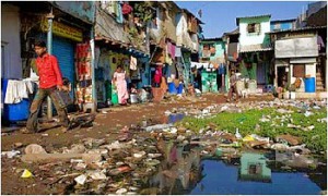
A colonia popular in Mexico

One of Mexico's many "colonias populares"

The land was subdivided into numerous small lots and sold on an installment plan to low-income families, who would construct low cost one room shacks which they called “home.” These neighborhoods were called “irregular” because many residents lacked legal deeds to their lots, their houses did not meet building codes, and they usually lacked important urban services.

Investors could not legally sell building lots without services such as water, drainage, paved streets, electricity and other basic infrastructure. However often investors did little more than mark the services on the property maps and provide “paper” services. Lots with actual services were considerably more expensive and beyond the reach of most of the urban poor. In general, local government tolerated these unserviced and illegal developments, because they helped relieve the low income housing crisis.

Street plan of a "colonia popular"

Street plan of a "colonia popular"

Developers could make fortunes with these housing schemes. In a one square kilometer piece of land they could sell up to 10,000 lots (each averaging 100 square meters, or 1076 square feet). At $200 a lot, this brought them $2 million. Developers often reneged on their promises to provide services, though their plans did at least provided vacant strips of land between lots, which became known as “paper streets”.

In the beginning, many “irregular” communities lacked running water, sewers, drainage, electricity, and public transport. However, eventually the needed services were provided and the residents upgraded their houses. After a decade or two, most of these communities became completely “regularized” with water, sewers, drainage, electricity, telephones, cable TV, retail stores, schools, bus routes, medical clinics, offices, and even movie theaters, shopping centers, and office buildings. In most large Mexican cities, roughly half of all current housing started as “colonias populares”.

Mexico’s urban geography is analyzed in chapters 21, 22 and 23 of Geo-Mexico: the geography and dynamics of modern Mexico. Buy your copy today, and read more about the fascinating history and structure of Mexico’s cities.

Jun 282010
 

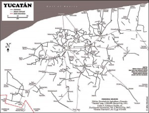
About 1900 one of the densest railroad networks on earth was operating in the Yucatán Peninsula. Between 1870 and 1920 the area experienced an economic boom based on the production of twine from sisal (oro verde or green gold). The numerous plantations in the area needed a way to move the sisal from the fields to processing centers and from there to ports for export. The plantation owners built a very extensive (4500 km) system of narrow gauge railroad system to move sisal as well as sugar and corn.

Map of Yucatan's railways

Map of Yucatan's railways. Copyright Allen Morrison. Reproduced by kind permission (see link to original map near end of this post). Click map for larger version.

The tracks stretched up to 100 km in all directions from Yucatán’s capital, Mérida. Rolling stock and complete sections of track with steel ties were imported mostly from Europe but also from the USA. The small trains were powered by mules, steam engines, electric batteries, and later by gasoline motors. There was no standard design. Several different gauges were in use ranging from 400 to 930 mm (15.7 to 36.6 in).

Foreign competition, the Mexican Revolution, and synthetic fibers brought an end to the sisal boom. Many of the plantations closed in 1930s. Soon small entrepreneurs were providing rail passenger services between the scores of towns in the area. Many families used the small sisal hauling cars as personal transport, powered by a horse or mule. This was far more efficient than animal drawn carts on the rough dirt roads, but required occasional de-railing to allow those going in the opposite direction to pass. Some of the Yucatán’s narrow gauge lines have survived into the 21st century, and some of the former sisal haciendas have reopened as luxury hotels for tourists.

Acknowledgments: Grateful thanks to Allen Morrison, who generously allowed us permission to reproduce his excellent map of Yucatán railways.

Mexico’s transportation systems are the subject of chapter 17 of Geo-Mexico: the geography and dynamics of modern Mexico. Buy your copy today!

Yucatán’s main line railway was not linked to the rest of Mexico until about 1950.

A small village in Mexico won a 2004 UN Development Prize

 Excerpts from Geo-Mexico  Comments Off on A small village in Mexico won a 2004 UN Development Prize
Jun 142010
 

Every two years, the United Nations Development Programme (UNDP) awards the Equator prize (worth 30,000 dollars) to communities that have shown “outstanding achievement in the reduction of poverty through the conservation and sustainable use of biodiversity.”

One of the winners of the 2004 Equator prize was the indigenous community of Nuevo San Juan Parangaricutiro, in the state of Michoacán. More than 340 communities, from 65 countries, were nominated for consideration by the Equator Prize jury. The seven winning communities were honored at a prize-giving ceremony held in conjunction with an international Biological Diversity Conference in Kuala Lumpur, in Malaysia.

The success of Nuevo San Juan Parangaricutiro (hereafter referred to simply as Nuevo SJP) is all the more remarkable since their community did not even exist prior to 1944.

That is the year when all the founding residents of Nuevo (New) SJP fled their homes in “viejo” (Old) SJP as the sizeable town was overwhelmed by the lava erupting from Paricutín volcano. Paricutín first erupted, completely unexpectedly, in the middle of a farmer’s field, on February 20, 1943. It is a sobering thought that only 61 years to the day before the prize-giving, the volcano literally did not exist.

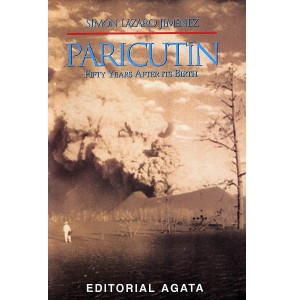
A remarkable account of those early days is given by Simón Lázaro Jiménez, who recounts in his book, Paricutín: 50 Years After Its Birth, his adventures as a young boy as he fled with his parents for safety as their small village of Angahuan was bombarded with red-hot rocks and ash. Don Simón’s is the only first-hand account of any substance written by a native P’urépecha speaker.

The volcano finally stopped erupting in 1952, but only after completely destroying the village of Parícutin (note that the position of the accent has changed over the years) and the town of viejo SJP. All that is left of the latter today are a few broken-down walls and parts of the huge, old church that did a brave job of withstanding the compelling force of the lava as it overran the rest of the town.

The people who fled the volcano (many initially refused to leave, but were escorted to safety by armed soldiers) stayed with friends and relatives and in makeshift camps before finding permanent accommodation, but later in 1944, founded Nuevo SJP after a presidential decree gave them land formerly belonging to the hacienda of Los Conejos.

The new town had to be completely planned from scratch. A gigantic church was built to commemorate the miraculous survival of part of the Old San Juan church which formed a partial barrier to the lava flow. Little by little a new community evolved, fostered in part by the high degree of cooperation required for building a new town and working virgin land.

In 1977, motivated by the abuse of local forest lands by private concession holders, the campesinos of Nuevo SJP organized their own union for farming and forestry workers. In 1981, they began their own forestry industry, and now collectively own and manage more than 11,000 hectares of pine, oak and fir forest. Over the years, their business activities have diversified to include a saw mill, a furniture factory (which has won export orders from Belgium and Ireland), a plant making wooden moldings for export to the USA, avocado and peach orchards, a packing plant which makes its own cases, a Christmas tree plantation, eco-tourism cabins and a resin distillation plant, as well as a store for the bulk purchase and resale of fertilizers. A water bottling plant, to bottle spring water, is one of the community’s latest proposals.

The community’s website gives details of all these activities and includes a link to a furniture catalog for those interested in buying direct. All the wood used is certified as “Smart Wood” (coming from well-managed forests) by the Forest Stewardship Council.

Community decisions in Nuevo SJP are made on behalf of the 8,000 or so residents by a General Assembly of the 1,300 Comuneros (community representatives), which has met at least once a month since 1983.

The Equator Prize was awarded because the forest policies adopted by the community “have provided a boost to local incomes while ensuring that the resource base upon which the community depends is sustained for future generations.” In addition, “the community’s successes have spread well beyond their origins as these novel conservation and business practices have been widely adopted by other indigenous communities in Mexico.”

Nuevo SJP may not be very old, or very large, but it certainly has a really big heart!

For a more detailed account of the history of the volcano, and of the considerable architectural attractions of the village of Angahuan, including its superb church, read chapter 35 of Western Mexico: A Traveler’s Treasury (Sombrero Books 2013).

Original article, as published on MexConnect

Mexico’s Volcanic Axis is discussed in chapter 2 of Geo-Mexico: the geography and dynamics of modern Mexico. The sustainable forestry project of San Juan Parangaricutiro is examined in chapter 15.

Jun 112010
 

Compared to its very large and loud northern neighbor the USA, Mexico often seems like a rather minor country. But let’s take a closer look at Mexico’s major characteristics.

Mexico is among the world leaders in land size, population and economic production. These three criteria are a rational way of determining the world’s major countries. Mexico is the world’s 14th largest country in area, just behind the Congo and Saudi Arabia, but ahead of Indonesia and Libya. Mexico’s population in 2009 was about 109 million ranking it 11th in the world.  Russia (140 million) and Japan (127 million) were slightly ahead of Mexico. Trailing Mexico were the Philippines (92 million) and Vietnam (87 million).

The Gross Domestic Product (GDP) of Mexico in 2009 was about $1.5 trillion, behind Brazil ($2.0 trillion) and Italy ($1.7 trillion), but ahead of South Korea (S1.4 trillion), Spain ($1.4 trillion) and Canada ($1.3 trillion). These GDP figures are based on “Purchasing Power Parity” which illuminates distortions based on exchange rates. For example, if a hair cut of equal quality costs $20 in the USA, $5 in Mexico and $2 in China, the haircut is counted as a $20 contribution the GDP of each country.

Mexico is one of only six countries that are in the top 15 in all three categories. The other five countries in this select group are China, India, the USA, Brazil and Russia.

That Mexico is in this very select group makes a very strong case that it is indeed a major country on the world stage.

For more information about these and many other aspects of Mexico, consider buying Geo-Mexico: the geography and dynamics of modern Mexico and adding it to your library.

The cultural geography of Mennonite enclaves in Mexico

 Excerpts from Geo-Mexico  Comments Off on The cultural geography of Mennonite enclaves in Mexico
Jun 082010
 

Among the first Mennonite settlers were a group of more than 1300 families (about 9300 individuals) of German-Russian descent who arrived from Canada in 1922. They had been guaranteed tax concessions, freedom of worship and exemption from military service by President Obregón. At the time the Mexican government wanted to encourage more settlement in northern Mexico which had unrealized agricultural potential. After the Mexican Revolution, the large landowners in northern Mexico wanted to sell part or all of their vast holdings before the federal government forced the break up of their estates.

Mennonites bought 100,000 hectares for 600,000 pesos (8.25 dollars per acre) and started a colony near Ciudad Cuauhtemoc, west of Chihuahua city.  The group’s spartan lifestyle is reflected in their conservative dress habits and the fact that their villages (campos) are numbered, rather than named.  The people are taller than the average Mexican, speak German, and have northern European physical features. Today, about 50,000 Mennonites live in the Ciudad Cuauhtemoc area. They also founded colonies at Patos, in northern Durango state, and near Saltillo in Coahuila. Today, there are also several Mennonite villages far to the south, in Campeche.

Mennonite cheese

Mennonite cheese (queso menonita)

The landscapes of Mennonite areas in northern Mexico are very distinctive. They transformed desolate areas of semi-arid scrubland into prosperous farms.

Houses built of adobe on wood frames line the main street of each campo. These elongated street villages (about sixty in number) are totally different to the compact, nucleated villages found elsewhere in Mexico.  Surrounding the villages are large relatively flat fields divided into blocks by wide roads.

The Mennonite farming areas look more like parts of the US Midwest than Mexico. The farms are neatly kept and dotted with wind pumps used to raise water for irrigation. Tractors are common though horse-drawn buggies are also used. The main crops are wheat, oats, beans, corn and in some areas apples. The Mennonites are experienced dairy farmers and their most famous contribution to Mexican cuisine is the production and marketing of Chihuahuan cheese (queso menonita). It is a common sight to see Mennonite men selling their delicious cheese at major intersections in several of Mexico’s major cities.

See also:

The geography of Mexico’s religions is discussed in chapter 11 of Geo-Mexico: the geography and dynamics of modern Mexico.

Aguascalientes’ geopolitical romance and long road to Statehood

 Excerpts from Geo-Mexico  Comments Off on Aguascalientes’ geopolitical romance and long road to Statehood
May 312010
 

How did the State of Aguascalientes come to be so small, and sandwiched between much larger states?

Aguascalientes coat-of-arms

The area that is now the State of Aguascalientes was caught between the colonial jurisdictions of Jalisco and Zacatecas.  Prior to the Mexican Revolution it was considered part of Zacatecas, but after the War of Independence, in 1821 it gained status as its own political entity. This lasted only a few years. In 1824 it became part of the State of Zacatecas.

A decade later, in 1835, Zacatecas rebelled against the Federal Government.  General Santa Anna and his army squashed the rebellion, ransacked the City of Zacatecas and seized large quantities of the state’s silver. As payback for the rebellion, the Mexican Legislature separated the agriculturally-rich Aguascalientes Territory from the State of Zacatecas.

The more romantic version is that, “the independence of Aguascalientes was sealed with a kiss, as the locals are invariably quick to point out.”  (Tony Burton, Western Mexico: A Traveler’s Treasury). While quelling the Zacatecan rebels, General Santa Anna met the beautiful Doña María Luisa Villa, the wife of the Aguascalientes’ mayor. Santa Anna was very attracted to her and promised her anything for a kiss. He got the kiss and fulfilled her promise by making Aguascalientes an independent territory under the governorship of her husband, Pedro García Rojas. Hence, the lips on the state’s coat-of-arms!

Detail from Aguascalientes coat-of-arms (Note the lips!)

But Aguascalientes’ independence did not last long. In 1847, the national legislature revoked its independence and put it back into the State of Zacatecas. However, a few years later in 1853, Aguascalientes regained independent status. Finally, under the new Mexican Constitution of 1857, Aguascalientes became Mexico’s 24th state, with the colonial city of Aguascalientes as its capital.

Aguascalientes is a rather small state. Among Mexican states it ranks in the lower 20% in both areal size and population (about 1.2 million).  Most of the population (over 900,000) lives in the industrial Aguascalientes Metropolitan Area.  Locals claim that the Aguascalientes Nissan plant is the largest outside of Japan.

The evolution of Mexico’s political boundaries is discussed in chapter 9 of Geo-Mexico: the geography and dynamics of modern Mexico.