admin

Western Mexico, Mexico’s Catholic heartland

 Excerpts from Geo-Mexico  Comments Off on Western Mexico, Mexico’s Catholic heartland
May 202010
 

As mentioned in an earlier post, Mexico is a predominately Catholic country. In 1980, 96% of Mexicans said they were Catholics; this dropped to 88% in 2000 and is estimated at about 80% in 2010. However, Catholicism seems to be maintaining its strength in Western Mexico.

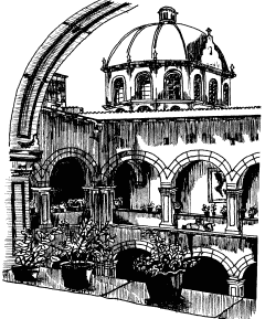
Tzintzuntzan monastery and church. Artist: Mark Eager. All rights reserved.

In 2000, 96% of those in Guanajuato and Aguascalientes professed to be Catholic, followed closely by Jalisco, Querétaro, Zacatecas and Michoacán with 95%. Colima (93%) and Nayarit (92%) were not far behind.

The 1917 Constitution which followed the Mexican Revolution placed severe restrictions on the Catholic Church. It forbade churches from participating in primary and secondary education, it denied legal standing to religious marriages, and denied the right of church personnel to criticize the government or wear religious attire in public. These laws began to be rigorously enforced in 1926, stimulating the Cristero Rebellion by 50,000 armed devout Catholics in Western Mexico. This three year war cost 80,000 lives and reduced the number of priests in Mexico from 4,500 to only 334. Many Catholic leaders and followers immigrated to the USA.

Gradually, the severe restrictions were virtually all rescinded. In 1992 the government re-established diplomatic relations with the Vatican after over a century of estrangement. The last two Presidents of Mexico have come from the pro-Catholic PAN political party.

The geography of Mexico’s religions is discussed in chapter 11 of Geo-Mexico: the geography and dynamics of modern Mexico.

Mexico’s population density compared to other countries. Is Mexico too crowded?

 Other, Teaching ideas  Comments Off on Mexico’s population density compared to other countries. Is Mexico too crowded?
May 192010
 

It is sometimes claimed that Mexico is ‘too crowded’ or ‘overpopulated’. Overpopulation, however, is an elusive concept, since it depends on the complex relationships between total population (and/or population density) and the resources available to support that population. In turn, the value of these resources depends in part on the technologies available to utilize them.

Even accepting that Mexico is not over-populated (since it apparently has sufficient resources to support its population), it is still interesting to compare Mexico’s population density with that of other countries.

CountryPopulation Density (persons per sq. km)
Mexico55
Bangladesh1127
India359
Japan337
UK337
Germany229
Italy200
Nigeria167
China 139
Indonesia121
Colombia40
USA31
Venezuela29
Brazil22
Argentina14
Canada3

As the table shows, Mexico’s overall population density of 55 persons per km2 is low, compared to Asian and European countries: Bangladesh (1127), India (359), Japan (337), UK (255) and Germany (229).

On the other hand, it is easily the highest among large countries in the New World like Colombia (40), USA (31), Venezuela (29) and Brazil (22).

Q. What are the implications for development of a country having a high density of population?

In a future post, we will consider whether or not Mexico’s population is evenly distributed across the country.

Perceptions of Mexico, from popular images to the “real” Mexico

 Other, Teaching ideas  Comments Off on Perceptions of Mexico, from popular images to the “real” Mexico
May 182010
 

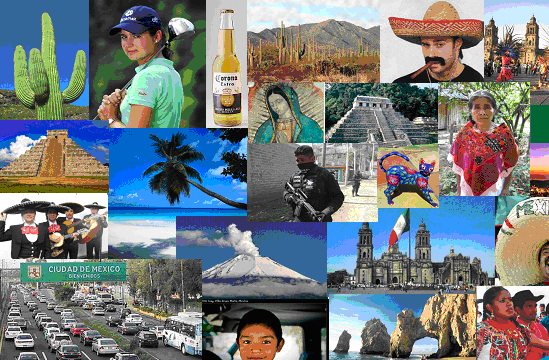
What comes to mind when the word “Mexico” is mentioned?

For most people, it brings to mind a variety of colorful images, such as those below, usually based on television, magazines, travel brochures and personal travels in Mexico. “Mexico” also is associated with verbal or written words or phrases, such as:

  • Drug wars
  • Illegal immigrants
  • Tacos and tamales
  • Tequila / Good beer
  • Fabulous beach resorts
  • Bargain prices
  • Poverty
  • Friendly people
  • Carlos Slim (the World’s richest man)
  • Deserts and cactus
  • Swine flu
  • Pre-Columbian ruins
  • Sombreros
  • Geo-Mexico (well maybe that last one is wishful thinking, but hopefully it will true someday)

Q. How many of these images can you identify?

These images and word phrases hold some truth, but do not begin to capture the full importance and significance of Mexico, something we try to do more thoroughly in Geo-Mexico: the geography and dynamics of modern Mexico.

For example, did you know that Mexico is one of only six countries ranked in the top 15 in the world in geographic size, population, and economic production? Furthermore, Mexico is one of the earth’s most biologically diverse countries. It ranks first in number of reptile, cactus and pine species; second in mammal species; and fourth in amphibian species.

There is lots more to Mexico than meets the eye in magazine and TV adverts – and that’s why you should consider buying your own copy of Geo-Mexico: the geography and dynamics of modern Mexico, rather than relying on your local library or extracts posted on this blog!

The decline of Catholicism in southern Mexico

 Excerpts from Geo-Mexico  Comments Off on The decline of Catholicism in southern Mexico
May 172010
 

The geography of religion in Mexico is changing quite rapidly.

Mexico is a predominately Catholic country, but is becoming less so with each passing decade.  In 1980 96% of Mexicans said they were Catholics; this dropped to 88% in 2000 and is estimated at about 80% in 2010. While the proportion non-Catholic is growing in all parts of the country, it is most apparent in southeastern Mexico.

In 2000, only 64% of those in Chiapas identified themselves as Catholics, fully 24% below the national average.  Other southern states were not far behind: Tabasco – 70%, Campeche – 71%, Quintana Roo – 74%; followed by Veracruz – 83%, Yucatán – 84% and Oaxaca – 85%.  Given existing trends, these percentages are expected to be considerably lower in the 2010 census.

About 10% of those in southern Mexico are classified as Protestant or Evangelical. Close to 10% are classified as having “no religion”, 13% in Chiapas. Indigenous language speakers and males were most likely to place themselves in this category.  The smallest, but fastest growing group in southern Mexico is the “Biblical, not Evangelical” group, which includes Seventh Day Adventists, Jehovah’s Witnesses, and Mormons.

The geography of Mexico’s religions is discussed in chapter 11 of Geo-Mexico: the geography and dynamics of modern Mexico.

May 152010
 

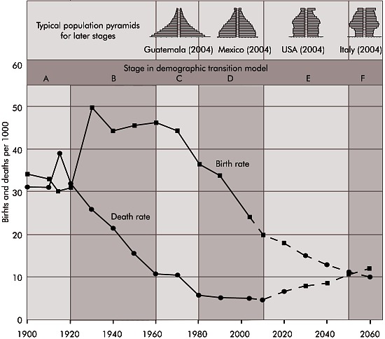
Mexico’s population exploded in the mid-20th century as death rates plummeted and birth rates remained high.  From 1940 to 1980, the number of Mexicans more than quadrupled from under 20 million to over 80 million.  In the 1960s and 1970s the population growth was among the world’s fastest at 3.3% a year.  At this rate, the population doubles in less than 22 years.

Mexico's birth rates, death rates and demographic transition

Concerns about overpopulation resulted in a massive planning program which included health professionals, multimedia advertising, and messages is telenovelas (serialized TV dramas) and historietas (comic books).  As a result of this campaign and the demographic transition (the drop in fertility rates with modernization observed in all countries), the average number of children per woman dropped dramatically from 5.7 in 1976 to about 2.2 in 2010.  Mexico’s population should peak at about 120–130 million in about 2045.  This is a fairly large spread because accurately predicting future rates of immigration to the USA is very tricky.

Mexico’s natural increase now is about 1.5%, but actual increase (including immigration/emigration) was closer to 1% in 2006, 1.3% in 2008 and will probably be down to 1% again by 2011.

Mexico’s National Population Council (CONAPO) has projected a fertility rate of 2.1 for 2010, but international sources estimate it to be between 2.2 and 2.3 in 2010.

Mexico’s population dynamics are the subject of chapter 9 of Geo-Mexico: the geography and dynamics of modern Mexico; the importance of telenovelas and historietas is discussed in chapter 18.

Where to find Mexico’s most beautiful señoritas

 Other  Comments Off on Where to find Mexico’s most beautiful señoritas
May 142010
 

The British-born journalist William English Carson (1870-1940) spent four months in Mexico, in 1908-1909, collecting material for his “Mexico, the Wonderland of the South“, never straying far from the railways. Always an enthusiastic traveler, many of his views about Mexicans will strike modern readers as stereotypical. For example, Carson devoted an entire chapter to “The Mexican Woman“. Many of Carson’s pronouncements read today as outrageous over-generalizations. Select quotes from the chapter include:

  • “no foreigner, unless he be associated with diplomacy, is likely to have any chance of studying and judging the Mexican women”
  • “the Mexican girl has but two things in life to occupy her, love and religion”
  • “As a rule, the Mexican women are not beautiful”.

Miss Mexico 2009

After due analysis, the latter claim can be swiftly disposed of! See, for example, this article on MexConnect.

Want to find out which state in Mexico has the most beautiful young señoritas? In chapter 13 of Geo-Mexico: the geography and dynamics of modern Mexico, we use locational quotients to analyze the geography of beauty pageant winners in Mexico

This is an edited version of an article originally published on MexConnect, partly based on chapter 52–“A place of contrasts”–of Lake Chapala Through the Ages, an anthology of travellers’ tales (Sombrero Books, 2008).

The 10 states of Mexico which have the longest coastline

 Other, Teaching ideas  Comments Off on The 10 states of Mexico which have the longest coastline
May 132010
 

Here are the ten states of Mexico which have the longest coastlines. Note that these figures are those published by the National Statistics and Geography Information Institute (INEGI). We discussed the impossibility of ever measuring a coastline accurately in a previous post:

How long is Mexico’s coastline?

RankStateLength of coast (km)
1Baja California Sur2,131
2Baja California1,493
3Sonora1,209
4Quintana Roo1,176
5Veracruz720
6Sinaloa622
7Oaxaca568
8Guerrero522
9Tamaulipas433
10Campeche425

Only seven other states have a marine coast. They are Jalisco, Yucatán, Nayarit, Chiapas, Michoacán, Tabasco and Colima.

The remaining 15 states (counting the Federal District as a state) are land-locked.

Q. What are the likely impacts on economic activity of either (a) having a coastline or (b) being landlocked?

May 122010
 

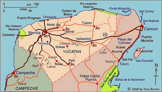
Yucatán state (see the map below) has an area of 39,612 square kilometers and a population of 1,945,840 (2010 estimate). Its distinctive landscapes include coastal rias (drowned river valleys, such as Celestún) and tropical karst (limestone scenery). The state’s capital city  is Mérida, the “white city” (2009 population: 955,000).

Map of Yucatán state. Copyright 2010 Tony Burton. All rights reserved.

The state was an important sisal-producing area during the 19th century. Sisal was exported all over the world through the port of Sisal [see comments], later surpassed as a port by Progreso.

The state has numerous important Mayan sites, including Uxmal and Chichen Itza. These sites have led to cultural tourism becoming very important to the state’s economy. Several cities, including Mérida and Izamal, have outstanding examples of colonial architecture. Several former sisal haciendas have been turned into luxurious hotels.

Several attempts have been made in recent decades to link the Yucatán Peninsula to the US Gulf coast by vehicle ferry, but none has yet succeeded. Such a route would save several days of driving time and would be a huge boost to overland tourism in the state, since many of its potential cultural and eco-tourist attractions are not very easy to reach by public transport.

Author Harriet Hart on Geo-Mexico

 Reviews of Geo-Mexico  Comments Off on Author Harriet Hart on Geo-Mexico
May 112010
 

“Once in a while a book comes along that I want to bring to people’s attention. Local author Richard Rhoda (with a PhD in geography) in collaboration with Tony Burton has created a book titled Geo-Mexico The Geography and Dynamics of Modern Mexico that is really exceptional… The book would make an excellent textbook.” Author Harriet Hart
[Thank you very much indeed, Harriet – we couldn’t have said it better ourselves!]

The mud volcanoes known as Los Negritos, in Michoacán, Mexico

 Other  Comments Off on The mud volcanoes known as Los Negritos, in Michoacán, Mexico
May 112010
 

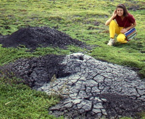
Los Negritos (the Little Black Ones) are a legacy of the volcanic heritage of most of central and western Mexico. They are located a few kilometers east of Jiquilpan in the state of Michoacán.

Two of the “Los Negritos” mud volcanoes. Photo: Tony Burton. All rights reserved.

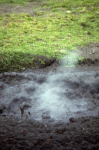
Los Negritos are small mud volcanoes (up to a meter or two across) which burble and gurgle, hiss and splutter, and occasionally erupt, throwing hot mud into the air and emitting sulfurous fumes. They are great fun to watch, but take care! Don̓t get too close or you may be splattered with the hot mud. Worse yet, you could step in the innocuous-looking but highly unstable surrounding mud patches which can rarely hold a person’s weight.

Other vestiges of volcanic action include several geysers, including the one at Ixtlán de los Hervores and the many thermal hot springs, now often utilized for tourist facilities and spas, scattered  throughout Mexico’s Volcanic Axis.

This is an edited extract from Western Mexico, A Traveler’s Treasury (Sombrero Books 2013).

Mexico’s volcanic landscapes are discussed in chapters 2 and 3 of Geo-Mexico: the geography and dynamics of modern Mexico.

Mud volcano puffs into action. Photo: Tony Burton. All rights reserved.

Markets in and near the city of Oaxaca

 Excerpts from Geo-Mexico  Comments Off on Markets in and near the city of Oaxaca
May 102010
 

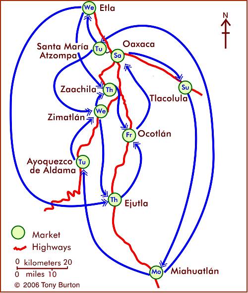
The southern state of Oaxaca is famous for its lively and colorful markets. Many villages have a weekly market, and it is possible to travel from one market to the next during a week in Oaxaca without ever visiting the same market twice.

The weekly cycle of markets in and around the city of Oaxaca, Mexico. Map: Tony Burton. All rights reserved.

This is not a coincidence, since it is precisely what many of the market vendors do every week in order to maximize the number of people exposed to their salesmanship and wares. This is related to an important concept in central place theory, that of the threshold population required to support a particular good or service.

Visiting even a single weekly market in Oaxaca is a fascinating way of experiencing first-hand some of the amazing cultural diversity of this  extraordinary state.

Click here for an interactive version of the map of markets in central Oaxaca. The geography of Mexico’s markets is discussed in chapter 24 of Geo-Mexico: the geography and dynamics of modern Mexico

Related article:

Oaxaca is the most culturally diverse state in Mexico

Map of the state of Campeche, Mexico

 Maps  Comments Off on Map of the state of Campeche, Mexico
May 082010
 

The state of Campeche (see map)  has an area of 57,925 square kilometers and a population of 608,535 (2010 estimate).

Its distinctive landscapes include a variety of coastal features and inland karst (limestone scenery). The state’s capital city  is Campeche, a colonial city which still preserves some of its ancient city walls and has UNESCO World Heritage status.  The most important city in the state economically is Ciudad del Carmen “the pearl of the Gulf”, center of the state’s involvement in Mexico’s oil industry, and an important base for offshore drilling.

Map of Campeche. Copyright 2009 Tony Burton. All rights reserved.

In the interior, the biosphere reserve of Calakmul has become an important tourist attraction.

The state’s economy looks set for a significant boost in coming decades as several major projects come to fruition. These include the first 6,000 hectares of a 30,000-hectare project on the coast of the Laguna de Términos for the commercial farming of rice and beans, and a similar sized forestry plantation project near Champoton specializing in the growing of scarce tropical hardwoods such as teak and mahogany.

May 072010
 

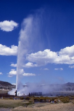
The geysers of Ixtlán de los Hervores have long attracted the attention of travelers. They are located north-west of the city of Zamora in the state of Michoacán. The temperature of the water emerging from underground varies between about 90 and 100 degrees Centigrade.

Here is how English explorer Captain George Lyon described them following his visit in 1826:

Photo: Tony Burton. All rights reserved.

”The plain is interesting, as being in some places covered by an efflorescence of muriate of soda, which forms a considerable article of commerce. The saline earth is collected into large vats, through which water is filtered, and then placed to evaporate in small well-cemented beds of about twelve feet by six. All this, however, interested me but little in comparison with the wells of boiling water, which to the amount of many hundreds are dispersed in a space of one mile and a half by a quarter of a mile in width, east and west along the plain, and sending up at intervals clouds of steam. In fact the whole surface of this place is nothing more than the crust of a volcano; and seven years back an earthquake opened a large rent in the plain,whence issued  fountains of the purest water, and of mud also, both of a boiling heat.

In the evening I rambled amongst the springs, which are of all forms and sizes, from holes not larger than an inch, through which the water is seen and heard boiling beneath, to large spaces of several yards in diameter; some as transparent as though distilled. Others, within a foot of them are turbid, or of boiling mud; and there is one called “El Pozo Verde,” in which, although perfectly clear, the water is of a fine deep green. The springs are in some places constantly tranquil, and varying in temperature  from 110̊ to 130̊; but in far the greater number the water boils up with amazing force and in one well, chosen at random, I cooked a piece of mutton of the size of an egg in four minutes and fifty seconds. All the fountains which have been sufficiently small to admit of it, have been choked up with stones and bushes, to prevent cattle from falling into them; yet a number of poor beasts are frequently thus destroyed.”

Lyon, G.F. 1828 Journal of a residence and tour in the Republic of Mexico in the year 1826, with some account of the mines of that country. London: John Murray.

Mexico’s volcanic landscapes are discussed in chapters 2 and 3 of Geo-Mexico: the geography and dynamics of modern Mexico.

Mexico’s national interests in the fight against drugs

 Mexico's geography in the Press  Comments Off on Mexico’s national interests in the fight against drugs
May 062010
 

The following paragraphs come from a Stratfor Geopolitical Intelligence Report about Mexico’s fight against the drug cartels, Mexico and the Failed State Revisited, by George Friedman, published on 6 April 2010. The link above is to the full text of the report.

The Drug War and Mexican National Interests

From Mexico’s point of view, interrupting the flow of drugs to the United States is not clearly in the national interest or in that of the economic elite. Observers often dwell on the warfare between smuggling organizations in the northern borderland but rarely on the flow of American money into Mexico. Certainly, that money could corrupt the Mexican state, but it also behaves as money does. It is accumulated and invested, where it generates wealth and jobs.

For the Mexican government to become willing to shut off this flow of money, the violence would have to become far more geographically widespread. And given the difficulty of ending the traffic anyway — and that many in the state security and military apparatus benefit from it — an obvious conclusion can be drawn: Namely, it is difficult to foresee scenarios in which the Mexican government could or would stop the drug trade. Instead, Mexico will accept both the pain and the benefits of the drug trade.

Mexico’s policy is consistent: It makes every effort to appear to be stopping the drug trade so that it will not be accused of supporting it. The government does not object to disrupting one or more of the smuggling groups, so long as the aggregate inflow of cash does not materially decline. It demonstrates to the United States efforts (albeit inadequate) to tackle the trade, while pointing out very real problems with its military and security apparatus and with its officials in Mexico City. It simultaneously points to the United States as the cause of the problem, given Washington’s failure to control demand or to reduce prices by legalization. And if massive amounts of money pour into Mexico as a result of this U.S. failure, Mexico is not going to refuse it.

The problem with the Mexican military or police is not lack of training or equipment. It is not a lack of leadership. These may be problems, but they are only problems if they interfere with implementing Mexican national policy. The problem is that these forces are personally unmotivated to take the risks needed to be effective because they benefit more from being ineffective. This isn’t incompetence but a rational national policy.

Moreover, Mexico has deep historic grievances toward the United States dating back to the Mexican-American War. These have been exacerbated by U.S. immigration policy that the Mexicans see both as insulting and as a threat to their policy of exporting surplus labor north. There is thus no desire to solve the Americans’ problem. Certainly, there are individuals in the Mexican government who wish to stop the smuggling and the inflow of billions of dollars. They will try. But they will not succeed, as too much is at stake. One must ignore public statements and earnest private assurances and instead observe the facts on the ground to understand what’s really going on.

“This report is republished with permission of STRATFOR” © Copyright 2010 STRATFOR.

An overview of the geography of drug trafficking in Mexico forms part of chapter 20 of Geo-Mexico: the geography and dynamics of modern Mexico. Buy your copy today!

Related articles in this mini-series:

Book describing Paricutín volcano in the state of Michoacán, Mexico

 Books and resources  Comments Off on Book describing Paricutín volcano in the state of Michoacán, Mexico
May 052010
 

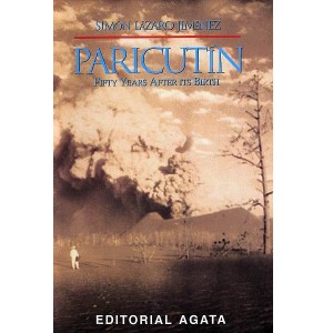
On February 20, 1943, Paricutín Volcano erupted in a farmer’s cornfield in Michoacán. Simón Lázaro Jiménez, now a carpenter by trade, was just a young boy. Here, for the first time, an indigenous P’urepecha Indian relives, in vivid and entertaining prose, his first-hand experiences on that fateful day and during the months that followed.

This 51-page softcover booklet includes simple maps and 16 previously unpublished photos, including several by acclaimed German photographer Walter Reuter.

Geo-Mexico is reader-supported. Purchases made via links on our site may, at no cost to you, earn us an affiliate commission. Learn more.

Paricutín, 50 years after its birth was written by Simón Lázaro Jiménez, and translated by Tony Burton. The booklet was published by Editorial Agata in 1994.

“Early that morning when we reached the town all the houses were completely deserted, with their doors open but nobody inside. We went round the town three times and found five men reciting the Holy Rosary…” (p 14)

“The first flows of lava oozed out of the volcano’s mouth and formed a hard initial slope but this didn’t work as Nature intended. It only resulted in reinforcing the side, enabling the volcano to increase its height, which is just what happened.” (p 23)

“The greatest number of tourists always arrived at night because this was the best time to appreciate, in all its splendor, in all its magnitude, this marvel of Nature, and the volcano, as if showing off its immense pride, threw its fiery stones as high as possible. These same stones would then totally cover everything…” (p 27)

The author tells a compelling tale, and one which might never have seen the light of day had it not been for the generosity of Editorial Agata in arranging its translation and publication.

Oaxaca is the most culturally diverse state in Mexico

 Excerpts from Geo-Mexico, Maps  Comments Off on Oaxaca is the most culturally diverse state in Mexico
May 042010
 

The inter-census population count in Mexico in 2005 found that more than one million people in Oaxaca spoke at least one indigenous Indian language. Close behind came the state of Chiapas with about 950,000 indigenous language speakers.

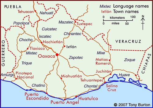
Indigenous Indian groups in the state of Oaxaca

In Oaxaca, according to the National Commission for the Development of Indigenous Peoples, more than 1.5 million people live in a home where at least one of the residents either speaks an indigenous language or considers themselves indigenous (even if they do not speak an indigenous language). This is 50% more people than are found in the same category in Chiapas.

Not only does Oaxaca have more indigenous people, it also has a much greater linguistic and cultural diversity than Chiapas or any other state in Mexico.

Oaxaca’s one million indigenous speakers represent 35% of the state’s total population. The largest indigenous linguistic groups in the state include about 350,000 Zapotec, 230,000 Mixtec, 165,000 Mazatec, 100,000 Chinantec, 100,000 Mixe, and 40,000 Chatino.

Almost 90% of Zapotec speakers also speak Spanish, which considerably enhances their education and employment opportunities. On the other hand, 23% of Mixtecs do not speak Spanish, and hence face a tougher challenge in the workplace. Tens of thousands of Mixtecs have migrated away from Oaxaca looking for work. Mixtec speakers tend to migrate to Mixtec-speaking neighborhoods; there are about 16,000 Mixtecs in Mexico City, 14,000 in Baja California, 13,000 in Sinaloa, and perhaps 50,000 in the USA. A sizable number of these migrants are essentially monolingual, with very limited Spanish.

The map shows the regions where the main indigenous groups in Oaxaca reside. One of the reasons for Oaxaca having retained such an extraordinary diversity of Indian groups is the state’s very rugged terrain, which has isolated numerous indigenous groups, cutting them off from mainstream Mexican society. This diversity of cultures helps to make Oaxaca one of Mexico’s most interesting states. The cultures find expression today not only in language, but also in modes of dress, handicrafts, music and dance. The state of Oaxaca celebrates its ethnic diversity in its annual extravaganza, the Guelaguetza festival, normally held in July.

Mexico’s cultural diversity is discussed in chapters 10 and 13 of Geo-Mexico: the geography and dynamics of modern Mexico.

This is an edited version of an article originally on MexConnect website.

The economic benefits to Mexico of the drugs trade

 Mexico's geography in the Press  Comments Off on The economic benefits to Mexico of the drugs trade
May 032010
 

The economics of the drug trade

The amount of money pouring into Mexico annually is stunning. It is estimated to be about $35 billion to $40 billion each year. The massive profit margins involved make these sums even more significant. Assume that the manufacturing sector produces revenues of $40 billion a year through exports. Assuming a generous 10 percent profit margin, actual profits would be $4 billion a year. In the case of narcotics, however, profit margins are conservatively estimated to stand at around 80 percent. The net from $40 billion would be $32 billion; to produce equivalent income in manufacturing, exports would have to total $320 billion.

In estimating the impact of drug money on Mexico, it must therefore be borne in mind that drugs cannot be compared to any conventional export. The drug trade’s tremendously high profit margins mean its total impact on Mexico vastly outstrips even the estimated total sales, even if the margins shifted substantially.

On the whole, Mexico is a tremendous beneficiary of the drug trade. Even if some of the profits are invested overseas, the pool of remaining money flowing into Mexico creates tremendous liquidity in the Mexican economy at a time of global recession. It is difficult to trace where the drug money is going, which follows from its illegality. Certainly, drug dealers would want their money in a jurisdiction where it could not be easily seized even if tracked. U.S. asset seizure laws for drug trafficking make the United States an unlikely haven. Though money clearly flows out of Mexico, the ability of the smugglers to influence the behavior of the Mexican government by investing some of it makes Mexico a likely destination for a substantial portion of such funds.

The money does not, however, flow back into the hands of the gunmen shooting it out on the border; even their bosses couldn’t manage funds of that magnitude. And while money can be — and often is — baled up and hidden, the value of money is in its use. As with illegal money everywhere, the goal is to wash it and invest it in legitimate enterprises where it can produce more money. That means it has to enter the economy through legitimate institutions — banks and other financial entities — and then be redeployed into the economy. This is no different from the American Mafia’s practice during and after Prohibition.

The paragraphs above are taken from a Stratfor Geopolitical Intelligence Report about Mexico’s fight against the drug cartels, Mexico and the Failed State Revisited, by George Friedman, published on 6 April 2010.

“This report is republished with permission of STRATFOR” © Copyright 2010 STRATFOR.

An overview of the geography of drug trafficking in Mexico forms part of chapter 20 of Geo-Mexico: the geography and dynamics of modern Mexico. Buy your copy today!

Related articles in this mini-series:

The wettest states in Mexico

 Other  Comments Off on The wettest states in Mexico
May 012010
 

The “top ten” states in Mexico for annual precipitation amounts are:

RankStateAnnual precipitation (mm)
1Tabasco2,406
2Chiapas1,969
3Oaxaca1,519
4Veracruz1,492
5Puebla1,271
6Quintana Roo1,263
7Campeche1,169
8Guerrero1,105
9Yucatán1,091
10Nayarit1,069

No other state normally receives more than 1,000 mm of precipitation, which in Mexico’s case is almost entirely rainfall.

As is evident from this list, the southern half of Mexico receives significantly more precipitation than the northern half. Among other implications, this means that the risk of flooding is greatest in states on this list such as Tabasco that are also low-lying and/or poorly drained.

Apr 302010
 

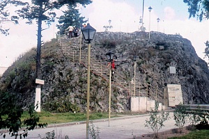
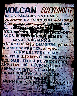
The Cuexcomate volcano, in a suburb of the city of Puebla, is generally considered to be the world’s smallest volcano.

The world's smallest volcano

Weighing in at an estimated 40 metric tons, it stands just 13 meters (43 feet) tall, with a reach (diameter) of 23 meters (75 feet). The name Cuexcomate derives from the Nahuatl Cuexcomac which means bowl or place for keeping things.

Mexico has thousands of volcanoes, and many very interesting ones, but Cuexcomate must surely be the only volcano in the country with a spiral staircase inside it! The volcano formed in 1664, as an offshoot parasitic cone during an eruption of a much larger volcano, Popocatépetl.

Cuexcomate is considered “inactive” and highly unlikely to burst into renewed activity. However,  Popocatépetl itself has been increasingly active over the past few years, leading to several temporary evacuations of the villages around its base. If Popocatépetl were to erupt violently again, some locals believe that perhaps the subterranean link to Cuexcomate might be re-established and the world’s smallest volcano could become somewhat larger…

Let’s hope that never happens. It would bring an end to one of the more unusual tourist attractions in this part of Mexico. Climbing down a spiral staircase into claustrophobic darkness is hardly an everyday experience for a tourist, or indeed for a vulcanologist. The crater is about eight meters across. Inside there is, frankly, not much to see apart from the inevitable lava!

Cuexcomate volcano is located in a residential suburb of the city of Puebla, a city better known for its proximity to archaeological sites, colonial buildings and a massive Volkswagen factory.

Factual note:
The world’s smallest active volcano is probably Mount Taal, located near the city of Tagaytay in the Philippines. It is a positively gargantuan 508 meters (1,660 feet) high, more than thirty-nine times the height of Cuexcomate, its Lilliputian cousin.

This is an edited version of an article first published on MexConnect: Original article

Volcanoes, in all their sizes and shapes are discussed in chapter 2 of Geo-Mexico: the geography and dynamics of modern Mexico

The disparities in Mexico between indigenous peoples and the remainder of the population

 Excerpts from Geo-Mexico  Comments Off on The disparities in Mexico between indigenous peoples and the remainder of the population
Apr 292010
 

Most of Mexico’s indigenous population lives in small, isolated rural localities with under 500 inhabitants. These communities are very disadvantaged compared with other Mexican communities. About one-third of the nation’s 2442 municipalities are indigenous. However, almost half of all the municipalities defined by the National Statistics Institute (INEGI) as “highly marginalized” are indigenous, as are a whopping 82% of the “very highly marginalized” municipalities.

The incidence of extreme poverty is much higher in indigenous municipalities than in non-indigenous municipalities. Indigenous villages are among the nation’s poorest rural communities. Indigenous language speakers trail behind other Mexicans in virtually every socioeconomic indicator. About 33% are illiterate, compared to the national rate of only 9.5%. Most leave school prematurely to help their families earn a living.

Indigenous females get a year’s less schooling than indigenous males. They suffer from poor nutrition and their fertility rate is 40% higher than the national average, but 5% of indigenous infants die before reaching their first birthday. About 85% of indigenous household are below the Mexican poverty line and over half live in “extreme poverty”. Over one third of houses lack electricity and over half lack piped water. There is no question. Indigenous peoples have a far lower standard of living than other Mexicans.

Despite their extreme poverty, indigenous communities have managed to remain remarkably stable while collectively pursuing their relatively well organized survival strategies. Their belief systems and rich knowledge of nature remain largely intact. Over 90% of indigenous peoples own their homes and farm plots.

Mexico’s indigenous groups are the subject of chapter 10 of of Geo-Mexico: the geography and dynamics of modern Mexico; variations in the quality of life within Mexico are analyzed in chapter 29.

Mexico’s export trade in drugs

 Mexico's geography in the Press  Comments Off on Mexico’s export trade in drugs
Apr 282010
 

These paragraphs come from a Stratfor Global Security and Intelligence Report by Fred Burton and Ben West, When the Mexican Drug Trade Hits the Border, published 15 April 2009 (republished with permission of STRATFOR).

Though the drug trade as a whole is highly complex, the underlying concept is as simple as getting narcotics from South America to the consuming markets — chief among them the United States, which is the world’s largest drug market. Traffickers use Central America and Mexico as a pipeline to move their goods north. The objective of the Latin American smuggler is to get as much tonnage as possible from Colombia, Peru and Bolivia to the lucrative American market and avoid interdictions by authorities along the way.

However, as narcotic shipments near the U.S.-Mexican border, wholesale trafficking turns into the more micro process of retail distribution. In southern Mexico, drug traffickers move product north in bulk, but as shipments cross the U.S. border, wholesale shipments are broken down into smaller parcels in order to hedge against interdiction and prepare the product for the end user. One way to think about the difference in tactics between trafficking drugs in Central America and Mexico and distributing drugs in the United States is to imagine a company like UPS or FedEx. Shipping air cargo from, say, New York to Los Angeles requires different resources than delivering packages to individual homes in southern California. Several tons of freight from the New York area can be quickly flown to the Los Angeles area. But as the cargo gets closer to its final destination, it is broken up into smaller loads that are shipped via tractor trailer to distribution centers around the region, and finally divided further into discrete packages carried in parcel trucks to individual homes.

As products move through the supply chain, they require more specific handling and detailed knowledge of an area, which requires more manpower. The same, more or less, can be said for drug shipments. This can be seen in interdiction reports. When narcotics are intercepted traversing South America into Mexico, they can be measured in tons; as they cross the border into the United States, seizures are reported in kilograms; and by the time products are picked up on the streets of U.S. cities, the narcotics have been divided into packages measured in grams. To reflect this difference, we will refer to the movement of drugs south of the border as trafficking and the movement of drugs north of the border as distributing.

As narcotics approach the border, law enforcement scrutiny and the risk of interdiction also increase, so drug traffickers have to be creative when it comes to moving their products. The constant game of cat-and-mouse makes drug trafficking a very dynamic business, with tactics and specific routes constantly changing to take advantage of any angle that presents itself.

The only certainties are that drugs and people will move from south to north, and that money and weapons will move from north to south. But the specific nature and corridors of those movements are constantly in flux as traffickers innovate in their attempts to stay ahead of the police in a very Darwinian environment. The traffickers employ all forms of movement imaginable, including:

  • Tunneling under border fences into safe houses on the U.S. side.
  • Traversing the desert on foot with 50-pound packs of narcotics. (Dirt bikes, ATVs and pack mules are also used.)
  • Driving across the border by fording the Rio Grande, using ramps to get over fences, cutting through fences or driving through open areas.
  • Using densely vegetated portions of the riverbank as dead drops.
  • Floating narcotics across isolated stretches of the river.
  • Flying small aircraft near the ground to avoid radar.
  • Concealing narcotics in private vehicles, personal possessions and in or on the bodies of persons who are crossing legally at ports of entry.
  • Bribing border officials in order to pass through checkpoints.
  • Hiding narcotics on cross-border trains.
  • Hiding narcotics in tractor trailers carrying otherwise legitimate loads.
  • Using boats along the Gulf coast.
  • Using human “mules” to smuggle narcotics aboard commercial aircraft in their luggage or bodies.
  • Shipping narcotics via mail or parcel service.

These methods are not mutually exclusive, and organizations may use any combination at the same time. New ways to move the product are constantly emerging.

“This report is republished with permission of STRATFOR” © Copyright 2010 STRATFOR.

An overview of the geography of drug trafficking in Mexico forms part of chapter 20 of Geo-Mexico: the geography and dynamics of modern Mexico. Buy your copy today!

Related articles in this mini-series:

An early scientific account of Lake Chapala, Mexico’s largest natural lake

 Other  Comments Off on An early scientific account of Lake Chapala, Mexico’s largest natural lake
Apr 272010
 

The first detailed scientific account of Lake Chapala was written by Henri Guillaume Galeotti. It was based on a visit to Chapala in February-March 1837, and published in French in 1839.

Galeotti (1814-1858) was born in Paris and  studied natural history at the Establissement Géographique de Brussels, founded in 1830 by Philippe Vandermaelen, a very famous Flemish cartographer. Vandermaelen produced an extraordinary world atlas, published in 1827, with 400 maps in six volumes, covering the entire world at a uniform scale of about 1:1,600,000.

Galeotti arrived in Mexico in December 1835; it turned out to be a visit which lasted several years. Galeotti was primarily a botanist, and was responsible for the first scientific descriptions of scores of plants, including a wide variety of cacti, for which he had a particularly fondness.
In his account of Lake Chapala, Galeotti starts with a detailed description, before providing some personal observations of storms:

“We have observed in the lake the phenomenon of occasional waves (seiches) which are in the habit of lasting plenty of time, with one part of the water remaining calm next to the rough part. This usually occurs at about five in the afternoon. We noted several of these singular effects, on February 27 and 28, and in March of 1837: the weather was calm and the temperature between 18 and 22 degrees Centigrade. The phenomenon is visible on the southern shore and in Tlachichilco and Chapala. The flood water rises from one to four feet (from 33 centimeters to 1.33 meters)…”

“From time to time, very strong whirlwinds or cloudbursts agitate the lake, snatching fish from their hideouts, and hurling them onto the nearby mountains. Some have been found on quite a high mountain near Ixtlahuacan, two leagues from the lake.”

Early map of Lake Chapala (Galeotti, 1837)

Galeotti goes on to provide a rich account of the varied flora and fauna, especially the birdlife, around the lake, including:

“(the) water sheep or pelicans (Pelecanus) which live on the island of Chapala, and fly in flocks of 50 or 60 individuals, at about five in the afternoon, to search for food on the shores, where some little fish called javai are abundant. The pelicans are very fierce and plump, and have white feathers with a yellowish green tint at the tips of their wings.”

“There is a great diversity of fish in the waters of the lake. The whitefish and the bagoc are very well-liked for the table. A great quantity of fish is caught in Easter week. The inhabitants of the vicinity subsist on little else apart from the product of this fishing, for which they prepare by building reed shacks on the shores of the lagoon, and lighting large bonfires between 6 and 7 in the evening to attract the fish.”

All in all, his article is a remarkable achievement for its time, and a true testimony to the powerful pull that Lake Chapala has had on so many foreign visitors.

Source: Galeotti, H. G. 1839 Coup d’oeil sur la Laguna de Chapala au Mexique, avec notes géognostiques. Translations by the author; all rights reserved.
Note:  This is an edited version of an article originally published on MexConnect, based on chapter 21–“The natural history of Lake Chapala”–of  Tony Burton’s Lake Chapala Through the Ages, an anthology of travelers’ tales (Sombrero Books, 2008).

The hydrology of Lake Chapala is discussed in chapters 6 and 7 of Geo-Mexico: the geography and dynamics of modern Mexico. A case study of ‘residential tourism’ in the villages on the northern shore of Lake Chapala is discussed in chapter19 of Geo-Mexico: the geography and dynamics of modern Mexico.

Related posts about Lake Chapala

Los Mochis and Topolobampo are two examples of “new towns” in Mexico

 Other  Comments Off on Los Mochis and Topolobampo are two examples of “new towns” in Mexico
Apr 262010
 

In north-western Mexico, two towns in close proximity—Los Mochis and Topolobampo—are both examples of “new towns”. Many Mexican towns and cities are more than 500 years old; relatively few major settlements in the country are less than 150 years old. How did it come about then that these two “new towns” in the state of Sinaloa were founded so close to one another?

Topolobampo dates back only as far as 1872, when a US engineer, Albert Kimsey Owen (1847-1916) arrived. Owen envisaged the city as a U.S. colony centered on sugar-cane production in this previously unsettled area and as the terminus for a railway across the Sierra Madre Occidental.

Owen had been raised in New Harmony, the city founded by Robert Owen (no relation) and decided to try and found a similar “ideal socialist” city somewhere in Mexico. In 1871-1872 he visited Chihuahua and Sinaloa and decided that the site of present day Topolobampo was ideal for his purposes. Owen founded the Texas, Topolobampo and Pacific Railroad and Telegraph Company (later the American and Mexican Pacific Railroad) and in 1881 was granted the concession for the settlement of a town.

Settlement began in October 1886. Two and a half years later, in April 1889, the first large group of colonists—300-strong—set sail from New York, arriving in Sinaloa in July, only to find a deserted beach and no Owen. Owen had returned to the USA but finally arrived the following year with another 30 colonists. During 1891, 70 more settlers arrived. They founded several additional settlements including Vegatown (Estación Vega), La Logia, El Público and El Platt. They also dug an irrigation canal, 12 kilometers long, to divert water from the Fuerte River across their lands. Despite their heroic efforts, the farming project was eventually abandoned, though the town of Topolobampo struggled on.

The Henry Madden Library of the California State University, Fresno, houses an amazing visual record of those early years, based on photos dating back to 1889-90 taken by Ira Kneeland, one of the first settlers.

Meanwhile, in 1893, another American, Benjamin Francis Johnston (1865-1937) founded the Eagle Sugar Co. (Compañia Azucarera Aguila S.A.) and constructed a factory, church, airport, dam, and the Memory Hill lighthouse. Ten years later, in 1903, Johnston officially founded Los Mochis. Johnston came to own more than 200,000 hectares. He built a veritable palace of a residence, including an indoor pool and even an elevator, one of the first in the country. The mansion’s garden, full of exotic plants, is now the city’s botanical gardens, Parque Sinaloa. The mansion itself was later torn down for a shopping plaza.

Historians and geographers have long questioned the precise motives of both Owen and Johnston, whose efforts have been described as more akin to capitalist expansion and neo-imperialism than any form of socialism. If they had come to fruition, Owen’s projects could have resulted in the annexation of a million square kilometers to a USA which had ambitious ideas of expansion at the time. Owen has been labeled variously a visionary, a madman or a conman and fraudster. Similarly, Johnston has also been regarded by some as a stooge for grandiose US expansionist plans.

Whatever the motives of their founders, both Topolobampo and Los Mochis had their start and have rarely looked back. Los Mochis gained importance as a major commercial center, marketing much of the produce grown on the enormous El Fuerte irrigation scheme. A large proportion of this produce is exported to the U.S. via the famous Copper Canyon railway. Los Mochis is the passenger terminus at the western end of the  line. For freight, the line continues to Topolobampo, “the lion’s watering place” or “tiger’s water”. The port, with its shrimp-packing plant, is at the head of one of Mexico’s finest natural harbors, the head of a drowned river valley or ria, which affords an unusually high degree of security in the event of hurricanes.

This is an edited version of an article originally published on MexConnect. Click here for the original article

Urban settlements in Mexico are discussed in chapters 21 and 22 of Geo-Mexico: the geography and dynamics of modern Mexico, with urban issues being the focus of chapter 23.
The geography of drug trafficking in Mexico

 Maps, Mexico's geography in the Press  Comments Off on The geography of drug trafficking in Mexico
Apr 242010
 

This article dates back to 2010. For updates, see:

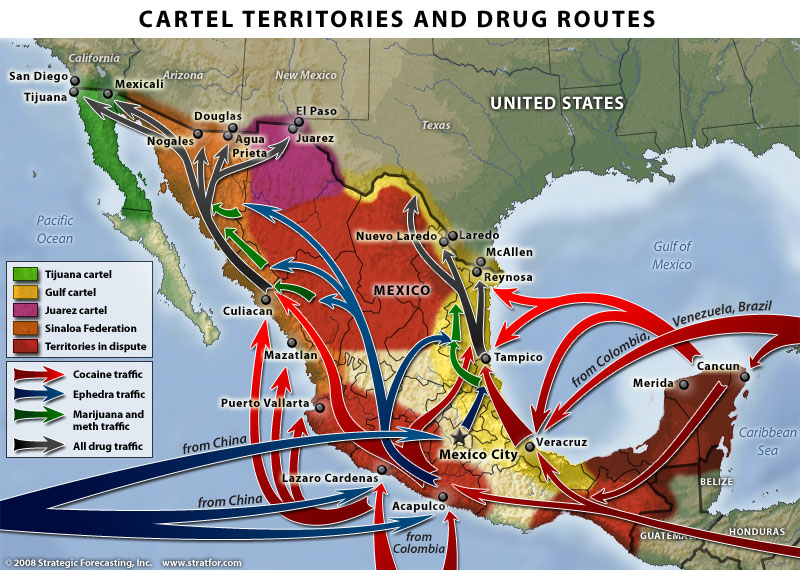
This map of drug cartel territories and drug trafficking and export routes comes from a Stratfor Global Security and Intelligence Report by Fred Burton and Ben West, When the Mexican Drug Trade Hits the Border, published 15 April 2009.

Map of Cartel Territories. Copyright Stratfor. Click map for enlarged version.

Click here to see map in its original context. Map © Copyright 2008 Strategic Forecasting Inc, STRATFOR www.stratfor.com. This map is republished with permission of STRATFOR.

The map shows the major routes for Mexico’s imports, transport and exports of drugs.  The boundaries between cartel territories are in a constant state of flux as rival cartels fight to enlarge their territories.

Perhaps the single biggest shift in the geography of drug trafficking in Mexico in recent decades has been that involving drugs originating in Colombia. Prior to the 1980s, Colombian drugs reached the US and Canada either direct or via the Caribbean. During the 1980s, as US pressure mounted on these routes, Colombian cartels shifted their supply routes to Mexico, where they needed the help of Mexican gangs. These gangs rapidly became better organized and have become the powerful Mexican cartels operating today.

Mexico’s on-going “war” against drugs cartels has had most success so far against the Gulf cartel and the Zetas, who started life as the enforcing arm of the Gulf cartel. On the other hand, the influence of the Sinaloa cartel appears to be spreading. For an analysis of the Gulf cartel, including the effects of globalization on its operations, see Stephanie Brophy’s “Mexico Cartels, corruption and cocaine: A profile of the Gulf cartel” (Global Crime, vol. 9, #3, August 2008, pp 248-261)

This article dates back to 2010. For updates, see:

An overview of the geography of drug trafficking in Mexico forms part of chapter 20 of Geo-Mexico: the geography and dynamics of modern Mexico. Buy your copy today!

Related articles in this mini-series:

The geography of languages in Mexico: Spanish and 62 indigenous languages

 Excerpts from Geo-Mexico  Comments Off on The geography of languages in Mexico: Spanish and 62 indigenous languages
Apr 232010
 

Most people realize that the national language of Mexico is Spanish and that Mexico is the world’s largest Spanish speaking country. In fact, its population, now numbering 105 million, represents about one-third of all the 330 million or so Spanish speakers in the world. Spanish is the majority language in nineteen other countries besides Mexico, and is the world’s third most spoken language, after English and Chinese.

Far fewer people realize that, in addition to Spanish, another 62 indigenous languages are also spoken in Mexico. This makes Mexico one of the most linguistically diverse countries in the world, in terms of the number of languages spoken, behind Papua New Guinea, Indonesia and India, but well ahead of China, Brazil and just about anywhere else.

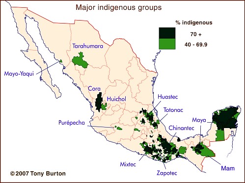
The major indigenous groups in Mexico

Some estimates put the number of different Indian languages in use at the time of the Spanish Conquest in the 16th century as high as 170. This number had dwindled to about 100 by 1900, and has continued to decline to the present day. The latest estimates are that at least 62 distinct languages (and 100 dialects) are still spoken somewhere in the country.

The largest indigenous groups are those speaking Nahuatl (2,563,000; dispersed locations, and therefore not shown on the map), Maya (1,490,000), Zapotec (785,000) and Mixtec (764,000), followed by those using Otomí (566,000), Tzeltal (547,000) and Tzotzil (514,000). Other well known groups include the 204,000 having Purépecha (or Tarasco) as their first language and the 122,000 speaking Tarahumara.

At the other end of the spectrum, only about 130 people still speak Lacandón and only 80 use Kiliwa. Only 60 people still use Aguacateco in Mexico and only 50 speak Techtiteco (or simply Teco), though both languages are spoken by several thousand Indians in neighboring Guatemala.

Of course, we shouldn’t forget that many Mexicans not only speak Spanish and/or an indigenous language, but also manage pretty well in English, French, Japanese and many others!

This is an edited version of an article originally published on MexConnect – click here for the original article

Indigenous languages and cultures are analyzed in chapters 10 of Geo-Mexico: the geography and dynamics of modern Mexico.

Medical tourism in Mexico, and where the Maya live

 Mexico's geography in the Press  Comments Off on Medical tourism in Mexico, and where the Maya live
Apr 222010
 

A few months ago, English journalist Rachel Rickard Straus wrote an article entitled “How I swapped a medical trial for a free holiday in Mexico” and published on the telegraph.co.uk website.

This is an interesting variation on the increasingly important field of medical tourism, much studied by geographers over the past decade or so. Several forms of medical tourism have been important in Mexico for a long time, mainly because of the significant price differential either side of the USA-Mexico border for almost all medical and dental procedures. Guadalajara was one of several cities where Americans could afford cosmetic surgery at the hands of (often) American-trained experts at a fraction of the cost back home, and were able to recuperate in relative luxury away from the preying eyes of family and colleagues.

Ms Straus appears to have thoroughly enjoyed her free holiday and apparently suffered no ill effects from the medical trial. Or did she?

Her article describes how she “lapped up the Mexican sunshine, admired the incredible Mayan pyramids and even took a road trip to San Miguel de Allende, a world heritage site.” This is fairly remarkable, since she managed all this without even leaving central Mexico! Presumably she actually meant either Aztec pyramids (if she visited El Templo Mayor in downtown Mexico City) or, much more likely the Teotihuacan pyramids, where Ms Straus had her picture taken. Archaeologists do not know all that much about the people who built the Teotihuacan pyramids, who are usually called simply Teotihuacanos. As any Mexican 5th grader knows, the Maya built their pyramids far to the east, in and around the Yucatán Peninsula, where sites such as Uxmal, Chichen Itza, Palenque, Calakmul and Tulum, among dozens of others, are proof of the Maya’s very considerable architectural skills.

Map of the state of Jalisco, including Guadalajara, Puerto Vallarta and Chapala

 Maps  Comments Off on Map of the state of Jalisco, including Guadalajara, Puerto Vallarta and Chapala
Apr 212010
 

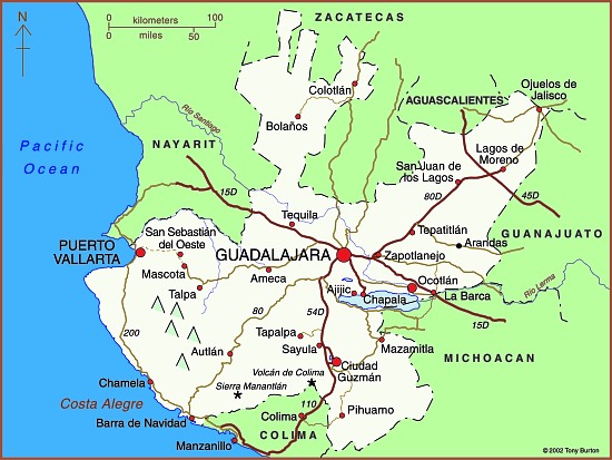
The state Jalisco (see map)  has an area of  78,609 square kilometers and a population of 7,070,555 (2010 estimate). The state’s capital city is Guadalajara, Mexico’s second largest city (2009 population: 4,365,000). On the outskirts of the city is an area of industry that is known as Mexico’s “Silicon Valley” because of its various computer-related factories.

The state is entirely within Mexico’s “Volcanic Axis” with varied scenery, encompassing everything from inland plateaus to rift valleys, volcanic peaks, calderas and coastal landforms. Its diverse altitudes mean that there are significant climate differences within the state.

Map of Jalisco. Copyright 2010 Tony Burton. All rights reserved.

Jalisco’s economy is very diversified. The state is a major agricultural producer, but also has an important manufacturing output, and also has a significant tourism industry, centered on the coastal resort of Puerto Vallarta. The villages of Ajijic and Chapala on the northern shore of Lake Chapala, Mexico’s largest natural lake, are the home to several thousand US/Canadian retirees.

Previous blog posts about Jalisco include:

The background to Mexico’s fight against the drug cartels

 Mexico's geography in the Press  Comments Off on The background to Mexico’s fight against the drug cartels
Apr 202010
 

The following paragraphs come from a Stratfor Geopolitical Intelligence Report about Mexico’s fight against the drug cartels, Mexico and the Failed State Revisited, by George Friedman, published on 6 April 2010. The link above is to the full text of the report.

Mexico’s Core Problem

Let’s begin by understanding the core problem. The United States consumes vast amounts of narcotics, which, while illegal there, make their way in abundance. Narcotics derive from low-cost agricultural products that become consumable with minimal processing. With its long, shared border with the United States, Mexico has become a major grower, processor and exporter of narcotics. Because the drugs are illegal and thus outside normal market processes, their price is determined by their illegality rather than by the cost of production. This means extraordinary profits can be made by moving narcotics from the Mexican side of the border to markets on the other side.

Whoever controls the supply chain from the fields to the processing facilities and, above all, across the border, will make enormous amounts of money. Various Mexican organizations — labeled cartels, although they do not truly function as such, since real cartels involve at least a degree of cooperation among producers, not open warfare — vie for this business. These are competing businesses, each with its own competing supply chain.

Typically, competition among businesses involves lowering prices and increasing quality. This would produce small, incremental shifts in profits on the whole while dramatically reducing prices. An increased market share would compensate for lower prices. Similarly, lawsuits are the normal solution to unfair competition. But neither is the case with regard to illegal goods.

The surest way to increase smuggling profits is not through market mechanisms but by taking over competitors’ supply chains. Given the profit margins involved, persons wanting to control drug supply chains would be irrational to buy, since the lower-cost solution would be to take control of these supply chains by force. Thus, each smuggling organization has an attached paramilitary organization designed to protect its own supply chain and to seize its competitors’ supply chains.

The result is ongoing warfare between competing organizations. Given the amount of money being made in delivering their product to American cities, these paramilitary organizations are well-armed, well-led and well-motivated. Membership in such paramilitary groups offers impoverished young men extraordinary opportunities for making money, far greater than would be available to them in legitimate activities.

The raging war in Mexico derives logically from the existence of markets for narcotics in the United States; the low cost of the materials and processes required to produce these products; and the extraordinarily favorable economics of moving narcotics across the border. This warfare is concentrated on the Mexican side of the border. But from the Mexican point of view, this warfare does not fundamentally threaten Mexico’s interests.

(to be continued) “This report is republished with permission of STRATFOR” © Copyright 2010 STRATFOR.

An overview of the geography of drug trafficking in Mexico forms part of chapter 20 of Geo-Mexico: the geography and dynamics of modern Mexico. Buy your copy today!

Organic farming helps the Mam of Chiapas regain their cultural identity

 Books and resources  Comments Off on Organic farming helps the Mam of Chiapas regain their cultural identity
Apr 192010
 

The Mexican Mam (there are also Guatemalan Mam) first settled in Chiapas in the late nineteenth century, mainly in the deforested mountains of the eastern part of the state. They had virtually disappeared from view as a cultural group by 1970, having lost most of their traditional customs. Today, the 8,000 or so Mam, living close to the Guatemala border, have shown that it is possible for some indigenous groups to re-invent themselves, to secure a stronger foothold in the modern world.

Mexican policies from 1935-1950 towards Indian groups were focused on achieving acculturation, so that the groups would gradually assume a mestizo identity. It was widely held at the time that otherwise such isolated groups would inevitably be condemned to perpetual extreme poverty. To the Mam, this period is known as the “burning of the clothes”. Almost all of them lost their language, traditional dress, and methods of subsistence, and even their religion, in the process. Indeed, for a time, the term Mam never appeared in any government documents.

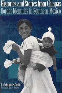
Cover of Histories and Stories bookFrom 1950-1970, the Mexican government opted for a modernization approach, building roads (including the Pan-American highway) and attempting to upgrade agricultural techniques. The mainstay of the regional economy is coffee. During this period, most Mam were peasant farmers, subsisting on corn and potatoes, gaining a meager income by working, at least seasonally, on coffee plantations. Working conditions were deplorable, likened in one report to “concentration camps”. Plantation owners forced many into indebtedness. The Mam refer to this period as the time of the “purple disease”: onchocercosis, spread by the so-called coffee mosquito. Untreated, it leads to depigmentation, turning the skin purple, skin lesions and blindness. Reaching epidemic proportions, it devastated the Mam peasants who had no access to adequate medical services.

After 1970, the Mam gradually re-found themselves, as official policy was to foment a multicultural nation. Some, especially many who had become Jehovah’s Witnesses, migrated northwards forming several small colonies, promoted by the government, in the Lacandon tropical rainforest on the border with Guatemala. Others, spurred on by Catholic clergy influenced by liberation theology, began agro-ecological initiatives.

For instance, one 1900-member cooperative, ISMAM (Indigenous People of the Motozintla Sierra Madre), specialized in the production of organic coffee. ISMAM’s agro-ecological initiatives benefited from the advice of the community’s elders and rescued many former sound agricultural practices, such as planting corn and beans alongside the coffee bushes to avoid the degradation that can result from monoculture. It halted the application of agrochemicals, and studied methods of organic agriculture and land restoration. Its coffee, adroitly marketed, commands premium prices, double those of regular coffee sold on the New York market. The Mam have effectively taken advantage of modern technology, from phones to e-mail, to overcome their isolation, and compete on their own terms, developing export markets in many European nations, as well as the U.S. and Japan.

At the same time, the Mam have re-invented their cultural identity and helped revive the language and traditional forms of dance. They have also rewritten their past. The revisionist version is that they always had the utmost respect for nature and had always lived in harmony with the environment. In reality, as historical geographers have demonstrated, this was not always the case. Whatever the historical reality, the defense of the earth, nature and their culture is now central to the Mam.

The main source for this post is R. Aída Hernández Castillo’s Histories and Stories from Chiapas. Border Identities in Southern Mexico (University of Texas Press, 2001).

Link to original article on MexConnect

Las Tuxtlas Biosphere Reserve in Veracruz, Mexico

 Other  Comments Off on Las Tuxtlas Biosphere Reserve in Veracruz, Mexico
Apr 172010
 

Scenically, the entire Tuxtlas region, in the south-eastern section of the  state of Veracruz, is one of the most fabulously beautiful in all of Mexico. High temperatures combined with lots of rainfall result in luxuriant vegetation and boundless wildlife. Average monthly temperatures range from a pleasant 21 degrees C (70 degrees F) in January to a high of 28 degrees C (82 degrees F) in May, just before the rainy season kicks in. During the rainy season, from June to October, some 2000 mm (79 inches) of rain falls, often in late afternoon tropical deluges.

The jungle masking the lower slopes of the San Martín volcano gradually merges into tropical cloud forest at higher altitudes. Competing with the Silk Cotton (Kapok) and Ficus trees for light and sustenance are ground-hugging ferns. Overhead, the tangle of tree branches provides support for thousands of non-parasitic bromeliads (“air” plants) and orchids. More than 1300 species of flowering plants have been identified in this classic area for Neotropical ecology.

Bird-watchers are likely to spot the spectacular Keel-billed Toucan, or hear a Tody Motmot. Smaller birds include several species of hummingbird; look for the endemic Long-tailed Sabrewing. About half of all the bird species recorded in Mexico have been seen here, but birds are not the only wild animals inhabiting the jungle. Ocelots and tapirs are regularly seen and you may be lucky enough to see spider monkeys playing overhead in the canopy.

Clearance of the land for grazing and cultivation of the slopes to grow tobacco, bananas and sugar cane have reduced the original jungle to a relatively small number of isolated fragments. Fortuitously, this provides more varied habitats than the original vegetation, helping to enrich the area’s wildlife, further enhancing the region’s reputation as an ornithological and botanical paradise.

Fortunately an extensive area of this region was declared a Biosphere Reserve in 1998, ensuring that conservation programs now go hand-in-hand with human activities. The total area forming the Reserva de la Biósfera “Los Tuxtlas” is 155,122 hectares (380,000 acres).

Click here for original article on MexConnect

Mexico’s varied climate zones are discussed in chapter 4 of  Geo-Mexico: the geography and dynamics of modern Mexico, while chapter 5 is devoted to Mexico’s ecosystems and biodiversity, including the nation’s many biosphere reserves.