Western Mexico, Mexico’s Catholic heartland

 Excerpts from Geo-Mexico  Comments Off on Western Mexico, Mexico’s Catholic heartland
May 202010
 
Western Mexico, Mexico's Catholic heartland

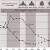
As mentioned in an earlier post, Mexico is a predominately Catholic country. In 1980, 96% of Mexicans said they were Catholics; this dropped to 88% in 2000 and is estimated at about 80% in 2010. However, Catholicism seems to be maintaining its strength in Western Mexico. In 2000, 96% of those in Guanajuato and Aguascalientes […]

Mexico’s population density compared to other countries. Is Mexico too crowded?

 Other, Teaching ideas  Comments Off on Mexico’s population density compared to other countries. Is Mexico too crowded?
May 192010
 

It is sometimes claimed that Mexico is ‘too crowded’ or ‘overpopulated’. Overpopulation, however, is an elusive concept, since it depends on the complex relationships between total population (and/or population density) and the resources available to support that population. In turn, the value of these resources depends in part on the technologies available to utilize them. […]

Perceptions of Mexico, from popular images to the “real” Mexico

 Other, Teaching ideas  Comments Off on Perceptions of Mexico, from popular images to the “real” Mexico
May 182010
 
Perceptions of Mexico, from popular images to the “real” Mexico

What comes to mind when the word “Mexico” is mentioned? For most people, it brings to mind a variety of colorful images, such as those below, usually based on television, magazines, travel brochures and personal travels in Mexico. “Mexico” also is associated with verbal or written words or phrases, such as: Drug wars Illegal immigrants […]

The decline of Catholicism in southern Mexico

 Excerpts from Geo-Mexico  Comments Off on The decline of Catholicism in southern Mexico
May 172010
 

The geography of religion in Mexico is changing quite rapidly. Mexico is a predominately Catholic country, but is becoming less so with each passing decade.  In 1980 96% of Mexicans said they were Catholics; this dropped to 88% in 2000 and is estimated at about 80% in 2010. While the proportion non-Catholic is growing in […]

May 152010
 
Mexico’s demographic transition and flirtation with overpopulation

Mexico’s population exploded in the mid-20th century as death rates plummeted and birth rates remained high.  From 1940 to 1980, the number of Mexicans more than quadrupled from under 20 million to over 80 million.  In the 1960s and 1970s the population growth was among the world’s fastest at 3.3% a year.  At this rate, […]

Where to find Mexico’s most beautiful señoritas

 Other  Comments Off on Where to find Mexico’s most beautiful señoritas
May 142010
 
Where to find Mexico's most beautiful señoritas

The British-born journalist William English Carson (1870-1940) spent four months in Mexico, in 1908-1909, collecting material for his “Mexico, the Wonderland of the South“, never straying far from the railways. Always an enthusiastic traveler, many of his views about Mexicans will strike modern readers as stereotypical. For example, Carson devoted an entire chapter to “The […]

The 10 states of Mexico which have the longest coastline

 Other, Teaching ideas  Comments Off on The 10 states of Mexico which have the longest coastline
May 132010
 

Here are the ten states of Mexico which have the longest coastlines. Note that these figures are those published by the National Statistics and Geography Information Institute (INEGI). We discussed the impossibility of ever measuring a coastline accurately in a previous post: How long is Mexico’s coastline? Only seven other states have a marine coast. […]

May 122010
 
Map of Yucatán state, including Chichen Itza, Progreso, Uzmal and Izamal

Yucatán state (see the map below) has an area of 39,612 square kilometers and a population of 1,945,840 (2010 estimate). Its distinctive landscapes include coastal rias (drowned river valleys, such as Celestún) and tropical karst (limestone scenery). The state’s capital city  is Mérida, the “white city” (2009 population: 955,000). The state was an important sisal-producing […]

Author Harriet Hart on Geo-Mexico

 Reviews of Geo-Mexico  Comments Off on Author Harriet Hart on Geo-Mexico
May 112010
 

“Once in a while a book comes along that I want to bring to people’s attention. Local author Richard Rhoda (with a PhD in geography) in collaboration with Tony Burton has created a book titled Geo-Mexico The Geography and Dynamics of Modern Mexico that is really exceptional… The book would make an excellent textbook.” Author […]

The mud volcanoes known as Los Negritos, in Michoacán, Mexico

 Other  Comments Off on The mud volcanoes known as Los Negritos, in Michoacán, Mexico
May 112010
 
The mud volcanoes known as Los Negritos, in Michoacán, Mexico

Los Negritos (the Little Black Ones) are a legacy of the volcanic heritage of most of central and western Mexico. They are located a few kilometers east of Jiquilpan in the state of Michoacán. Los Negritos are small mud volcanoes (up to a meter or two across) which burble and gurgle, hiss and splutter, and […]

Markets in and near the city of Oaxaca

 Excerpts from Geo-Mexico  Comments Off on Markets in and near the city of Oaxaca
May 102010
 
Markets in and near the city of Oaxaca

The southern state of Oaxaca is famous for its lively and colorful markets. Many villages have a weekly market, and it is possible to travel from one market to the next during a week in Oaxaca without ever visiting the same market twice. This is not a coincidence, since it is precisely what many of […]

Map of the state of Campeche, Mexico

 Maps  Comments Off on Map of the state of Campeche, Mexico
May 082010
 
Map of the state of Campeche, Mexico

The state of Campeche (see map)  has an area of 57,925 square kilometers and a population of 608,535 (2010 estimate). Its distinctive landscapes include a variety of coastal features and inland karst (limestone scenery). The state’s capital city  is Campeche, a colonial city which still preserves some of its ancient city walls and has UNESCO […]

May 072010
 
The geysers of Ixtlán de los Hervores

The geysers of Ixtlán de los Hervores have long attracted the attention of travelers. They are located north-west of the city of Zamora in the state of Michoacán. The temperature of the water emerging from underground varies between about 90 and 100 degrees Centigrade. Here is how English explorer Captain George Lyon described them following […]

Mexico’s national interests in the fight against drugs

 Mexico's geography in the Press  Comments Off on Mexico’s national interests in the fight against drugs
May 062010
 

The following paragraphs come from a Stratfor Geopolitical Intelligence Report about Mexico’s fight against the drug cartels, Mexico and the Failed State Revisited, by George Friedman, published on 6 April 2010. The link above is to the full text of the report. The Drug War and Mexican National Interests From Mexico’s point of view, interrupting […]

Book describing Paricutín volcano in the state of Michoacán, Mexico

 Books and resources  Comments Off on Book describing Paricutín volcano in the state of Michoacán, Mexico
May 052010
 
Book describing Paricutín volcano in the state of Michoacán, Mexico

On February 20, 1943, Paricutín Volcano erupted in a farmer’s cornfield in Michoacán. Simón Lázaro Jiménez, now a carpenter by trade, was just a young boy. Here, for the first time, an indigenous P’urepecha Indian relives, in vivid and entertaining prose, his first-hand experiences on that fateful day and during the months that followed. This […]

Oaxaca is the most culturally diverse state in Mexico

 Excerpts from Geo-Mexico, Maps  Comments Off on Oaxaca is the most culturally diverse state in Mexico
May 042010
 
Oaxaca is the most culturally diverse state in Mexico

The inter-census population count in Mexico in 2005 found that more than one million people in Oaxaca spoke at least one indigenous Indian language. Close behind came the state of Chiapas with about 950,000 indigenous language speakers. In Oaxaca, according to the National Commission for the Development of Indigenous Peoples, more than 1.5 million people […]

The economic benefits to Mexico of the drugs trade

 Mexico's geography in the Press  Comments Off on The economic benefits to Mexico of the drugs trade
May 032010
 

The economics of the drug trade The amount of money pouring into Mexico annually is stunning. It is estimated to be about $35 billion to $40 billion each year. The massive profit margins involved make these sums even more significant. Assume that the manufacturing sector produces revenues of $40 billion a year through exports. Assuming […]

The wettest states in Mexico

 Other  Comments Off on The wettest states in Mexico
May 012010
 

The “top ten” states in Mexico for annual precipitation amounts are: No other state normally receives more than 1,000 mm of precipitation, which in Mexico’s case is almost entirely rainfall. As is evident from this list, the southern half of Mexico receives significantly more precipitation than the northern half. Among other implications, this means that […]

Apr 302010
 
The world's smallest volcano is in Puebla, Mexico

The Cuexcomate volcano, in a suburb of the city of Puebla, is generally considered to be the world’s smallest volcano. Weighing in at an estimated 40 metric tons, it stands just 13 meters (43 feet) tall, with a reach (diameter) of 23 meters (75 feet). The name Cuexcomate derives from the Nahuatl Cuexcomac which means […]

The disparities in Mexico between indigenous peoples and the remainder of the population

 Excerpts from Geo-Mexico  Comments Off on The disparities in Mexico between indigenous peoples and the remainder of the population
Apr 292010
 

Most of Mexico’s indigenous population lives in small, isolated rural localities with under 500 inhabitants. These communities are very disadvantaged compared with other Mexican communities. About one-third of the nation’s 2442 municipalities are indigenous. However, almost half of all the municipalities defined by the National Statistics Institute (INEGI) as “highly marginalized” are indigenous, as are […]

Mexico’s export trade in drugs

 Mexico's geography in the Press  Comments Off on Mexico’s export trade in drugs
Apr 282010
 

These paragraphs come from a Stratfor Global Security and Intelligence Report by Fred Burton and Ben West, When the Mexican Drug Trade Hits the Border, published 15 April 2009 (republished with permission of STRATFOR). Though the drug trade as a whole is highly complex, the underlying concept is as simple as getting narcotics from South […]

An early scientific account of Lake Chapala, Mexico’s largest natural lake

 Other  Comments Off on An early scientific account of Lake Chapala, Mexico’s largest natural lake
Apr 272010
 
An early scientific account of Lake Chapala, Mexico's largest natural lake

The first detailed scientific account of Lake Chapala was written by Henri Guillaume Galeotti. It was based on a visit to Chapala in February-March 1837, and published in French in 1839. Galeotti (1814-1858) was born in Paris and  studied natural history at the Establissement Géographique de Brussels, founded in 1830 by Philippe Vandermaelen, a very […]

Los Mochis and Topolobampo are two examples of “new towns” in Mexico

 Other  Comments Off on Los Mochis and Topolobampo are two examples of “new towns” in Mexico
Apr 262010
 

In north-western Mexico, two towns in close proximity—Los Mochis and Topolobampo—are both examples of “new towns”. Many Mexican towns and cities are more than 500 years old; relatively few major settlements in the country are less than 150 years old. How did it come about then that these two “new towns” in the state of […]

The geography of drug trafficking in Mexico

 Maps, Mexico's geography in the Press  Comments Off on The geography of drug trafficking in Mexico
Apr 242010
 
The geography of drug trafficking in Mexico

This article dates back to 2010. For updates, see: Mexico’s drug cartels and their shifting areas of operation, a 2012 update Mexico’s drug cartels and their areas of operation, a 2014 update This map of drug cartel territories and drug trafficking and export routes comes from a Stratfor Global Security and Intelligence Report by Fred […]

The geography of languages in Mexico: Spanish and 62 indigenous languages

 Excerpts from Geo-Mexico  Comments Off on The geography of languages in Mexico: Spanish and 62 indigenous languages
Apr 232010
 
The geography of languages in Mexico: Spanish and 62 indigenous languages

Most people realize that the national language of Mexico is Spanish and that Mexico is the world’s largest Spanish speaking country. In fact, its population, now numbering 105 million, represents about one-third of all the 330 million or so Spanish speakers in the world. Spanish is the majority language in nineteen other countries besides Mexico, […]

Medical tourism in Mexico, and where the Maya live

 Mexico's geography in the Press  Comments Off on Medical tourism in Mexico, and where the Maya live
Apr 222010
 

A few months ago, English journalist Rachel Rickard Straus wrote an article entitled “How I swapped a medical trial for a free holiday in Mexico” and published on the telegraph.co.uk website. This is an interesting variation on the increasingly important field of medical tourism, much studied by geographers over the past decade or so. Several […]

Map of the state of Jalisco, including Guadalajara, Puerto Vallarta and Chapala

 Maps  Comments Off on Map of the state of Jalisco, including Guadalajara, Puerto Vallarta and Chapala
Apr 212010
 
Map of the state of Jalisco, including Guadalajara, Puerto Vallarta and Chapala

The state Jalisco (see map)  has an area of  78,609 square kilometers and a population of 7,070,555 (2010 estimate). The state’s capital city is Guadalajara, Mexico’s second largest city (2009 population: 4,365,000). On the outskirts of the city is an area of industry that is known as Mexico’s “Silicon Valley” because of its various computer-related […]

The background to Mexico’s fight against the drug cartels

 Mexico's geography in the Press  Comments Off on The background to Mexico’s fight against the drug cartels
Apr 202010
 

The following paragraphs come from a Stratfor Geopolitical Intelligence Report about Mexico’s fight against the drug cartels, Mexico and the Failed State Revisited, by George Friedman, published on 6 April 2010. The link above is to the full text of the report. Mexico’s Core Problem Let’s begin by understanding the core problem. The United States […]

Organic farming helps the Mam of Chiapas regain their cultural identity

 Books and resources  Comments Off on Organic farming helps the Mam of Chiapas regain their cultural identity
Apr 192010
 
Organic farming helps the Mam of Chiapas regain their cultural identity

The Mexican Mam (there are also Guatemalan Mam) first settled in Chiapas in the late nineteenth century, mainly in the deforested mountains of the eastern part of the state. They had virtually disappeared from view as a cultural group by 1970, having lost most of their traditional customs. Today, the 8,000 or so Mam, living […]

Las Tuxtlas Biosphere Reserve in Veracruz, Mexico

 Other  Comments Off on Las Tuxtlas Biosphere Reserve in Veracruz, Mexico
Apr 172010
 

Scenically, the entire Tuxtlas region, in the south-eastern section of the  state of Veracruz, is one of the most fabulously beautiful in all of Mexico. High temperatures combined with lots of rainfall result in luxuriant vegetation and boundless wildlife. Average monthly temperatures range from a pleasant 21 degrees C (70 degrees F) in January to […]