Magic Towns #58-62: Chiapa de Corzo, Comitán de Domínguez, Huichapan, Tequisquiapan, Batopilas

 Mexico's geography in the Press  Comments Off on Magic Towns #58-62: Chiapa de Corzo, Comitán de Domínguez, Huichapan, Tequisquiapan, Batopilas
Oct 252012
 

Well… the spate of Magic Town nominations shows no sign of slowing down. The federal Tourism Secretariat has announced that it hopes to have 70 towns in the program before the new administration takes office in December. The latest five additions to the list of Magic Towns are:

#58 Chiapa de Corzo, Chiapas

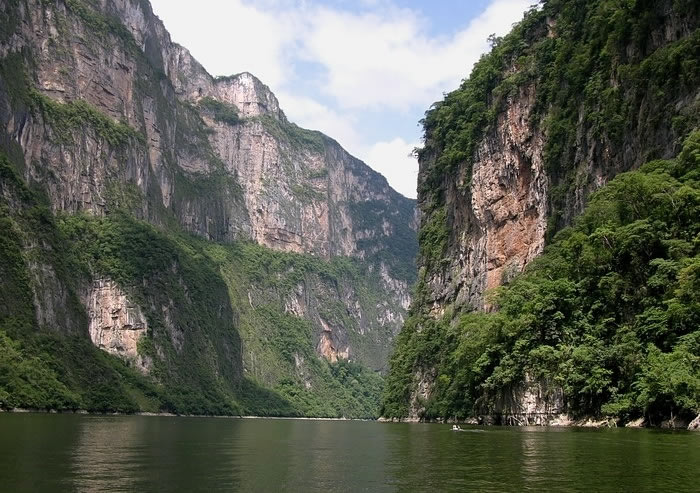
Chiapa de Corzo is a small city (2010 population:  45,000), founded in 1528, located where the PanAmerican Highway (Highway 190) from Oaxaca to San Cristobál de las Casas crosses the River Grijalva, 15 km east of Tuxtla Gutiérrez, in the state of Chiapas. It is the site of the earliest known Mesoamerican tomb burial and has considerable archaeological significance. The massive La Pila fountain, dating from 1562, is one of the most distinctive structures anywhere in Mexico. The town has more than its share of historical interest, including the well-preserved 16th century Santo Domingo church/monastery and a museum dedicated to traditional lacquer work (a local craft). It is best known to tourists as the main starting point for boat trips along the Grijalva River into the Sumidero Canyon National Park.

Sumidero Canyon National Park

Sumidero Canyon National Park

#59 Comitán de Domínguez, Chiapas

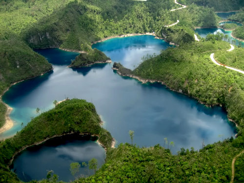
Comitán is a town of about 85,000 people, south-east of San Cristobál de las Casas, and close to the border with Guatemala. The town attracts mainly Mexican tourists on their way to the Lagunas de Montebello National Park and several remote Mayan archaeological sites in the border zone.

Lagunas de Montebello National Park

Lagunas de Montebello National Park

#60 Huichapan, Hidalgo

Huichapan has some interesting history and architecture, but relatively little to interest the general tourist. (Even Wikipedia has little to say about this town!)

#61 Tequisquiapan, Querétaro

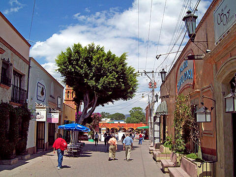
This very pretty town has already been described in several previous posts on geo-mexico.com, including:

Tequisquiapan

Tequisquiapan

#62 Batopilas, Chihuahua

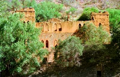
Designated in mid-October 2012. This small town, situated at an elevation of 501 meters above sea level, on the floor of the picturesque Batopilas Canyon, in Mexico’s Copper Canyon region, was once an important silver-mining center. The great German explorer, Alexander von Humboldt called Batopilas the “metallic marvel of the world”. Some of the old buildings in Batopilas have been restored in recent years. Still in ruins is the former dwelling of Alexander Robert Shepherd, one-time Governor of the District of Colombia, USA.

Ruins of former Shepherd mansion, Batopilas

Ruins of former Shepherd mansion, Batopilas

In 1880, Shepherd moved here, complete with family, friends, workers, dogs and grand-piano. His son, Grant Shepherd, describes in his book, The Silver Magnet, how this piano, the first ever seen in this part of Mexico, was carried overland more than 300 km in three weeks by teams of men, each paid the princely sum of US$1.00 a day for his efforts! Shepherd lived here for thirty years, running a silver mine and entertaining stray foreigners who passed through. He employed English servants. When the Mexican Revolution began, he abandoned Batopilas and the mansion fell into ruins. Shepherd is said to have mined more than US$22 million worth of silver here; he was behind the amalgamation of all the mines into a single company, the Consolidated Batopilas Mining Co. in 1887.

Related posts:


Oct 012012
 

Mexico currently has 65 Magic Towns (Pueblos Mágicos), some of which we have described in previous posts. Regular readers will know we have some reservations about the program, especially about the inclusion on the list of some places that have relatively little to attract the average tourist.

Are Magic Towns distributed evenly across the country?

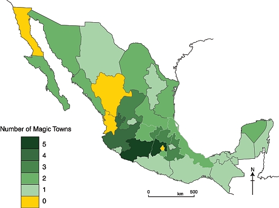
The map shows the distribution of the 57 Magic Towns, by state, as of 1 October 2012. Magic Towns are clearly not evenly distributed across Mexico. Two states – the State of México and Michoacán– each have five Magic Towns, while Jalisco has four. It is no surprise that the Federal District (México D.F.) is not designated a Magic Town, but it is a surprise that there are no Magic Towns in Baja California, Durango or Nayarit. Mexcaltitán, an island town in Nayarit, was one of the first towns in Mexico to be designated a Magic Town, but had this status revoked in 2009.

Mexico's Magic Towns, by state (September 2012)

Mexico’s Magic Towns, by state (September 2012)

Southern Mexican states appear to be drastically underrepresented, especially when area of state, population and indigenous groups are taken into account.

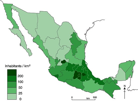
Population density map

Mexico’s population density in 2010

Larger states (in area and/or population) would surely  be more likely to have more Magic Town candidates. However, it is clear from comparing the maps of Magic Towns and population density (above) that the number of Magic Towns does not appear to be related to either the area of states, or to their population density.

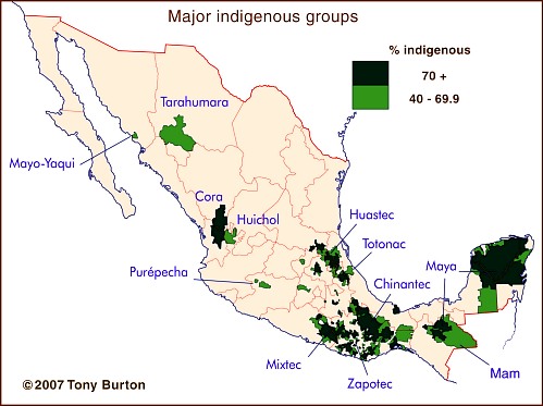
The major indigenous groups in Mexico

The major indigenous groups in Mexico

Indigenous groups are relevant because they tend to live in relatively remote areas of great natural beauty, such as the Copper Canyon region or the Huasteca, and they also exhibit many distinctive cultural traits, giving them a head-start in the race to demonstrate their attractiveness for tourism. Again, though, there is little common ground between the map of indigenous groups and the map of Magic Towns. In particular, the states of Guerrero, Oaxaca and Campeche all seem to have fewer Magic Towns than might be expected.

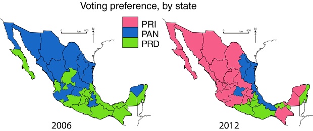
Voting patterns in presidential elections, 2006 and 2012

Voting patterns in presidential elections, 2006 and 2012. All rights reserved.

Even politics does not appear to help explain the distribution of Magic Towns, though it must be pointed out that the pattern of voting for presidential elections (maps) may not match the pattern of municipal voting which would be more relevant to applications for Magic Town status.

If and when more towns are added to the Magic Towns list, perhaps the reasons for their distribution will become more obvious.

This post examined the distribution of Mexico’s Magic Towns, as of 1 October 2012, at which point there were only 57 in total. Since this post was written, additional Magic Towns include:

There is no doubt that Mexico has many other places that would be very worthy additions to the list. Which places would you add?

Related posts:

Sep 282012
 

According to local press reports, Mexico’s Tourism Minister Gloria Guevara has confirmed that Mexico’s Magic Towns program is being considered for adoption by several other countries. Mexican tourism officials are reportedly advising their counterparts in El Salvador, Ecuador, Colombia and Chile how best to implement the program, which is designed to boost “cultural tourism”, usually to lesser-known, non-resort destinations. The program provides federal government help to improve tourist-related infrastructure and publicity.

Mexico’s own Magic Towns program now has 57 members, and the number shows no sign of slowing down, despite repeated claims by tourism officials that the program was to end this year.

In theory, Magic Towns should have local culture, handicrafts, architecture, festivals, gastronomy or traditions that offer a significant attraction for “sustainable” tourism. In practice, some of the places on the list, especially some of the more recent entries, are of dubious merit. As I’ve suggested in some previous posts, the Magic Towns program appears to be outliving its usefulness.

In a future post, we will take a closer look at the current distribution of Mexico’s Magic Towns.

Related post [with links to our Magic Towns mini-series]:

Mexico’s three latest Magic Towns (#55, 56, 57) include Loreto, former capital of the Californias

 Updates to Geo-Mexico  Comments Off on Mexico’s three latest Magic Towns (#55, 56, 57) include Loreto, former capital of the Californias
Sep 272012
 

It is getting just as hard to keep up with Mexico’s Magic Towns program as it is to understand why some of the places deserve to be included on the list. Since our last post about Magic Towns, three more places have been added:

#55 Loreto (Baja California Sur)

The attractive town of Loreto [ed: deservedly on the list], is built on the coast around a centuries-old mission. The town has a full range of tourist services, from expensive and ultra-luxurious to budget.

The first colonial Jesuit mission in this region was at San Bruno, 25 kilometers north of Loreto; it was founded in 1683, but lasted only two years. In February 1697, the Spanish Viceroy granted Jesuit priests Juan María de Salvatierra and Eusebio Francisco Kino permission to go to the “California Province“. This is apparently the earliest recorded mention of California as a geographic entity.

The Loreto mission, founded later that year, became extremely successful. Jesuit priests set out from Loreto to found missions throughout the Baja California Peninsula, most of them established by about 1720. Loreto was sufficiently important to function as the capital of the Californias (including the present-day U.S. state) until 1777.

#56 Valladolid (Yucatán)

Valladolid, located about half-way between Mérida and Cancún, is well worthy of Magic Town status. Founded in 1543, it is an attractive colonial city, with wide streets and considerable historical importance. The city has become increasingly popular among discerning tourists in recent years.

There are many attractions, including the numerous superb colonial buildings, such as the Cathedral in the center, and the Franciscan mission of San Bernardino de Siena, in the Sisal district of the city. The local Maya people, in traditional attire, bustle about the central square as they carry out their daily tasks. Valladolid is small enough to explore on foot, by strolling through the different districts of the city.

Coupled with excellent traditional Yucatecan cuisine, natural wonders like Cenote Zaci (a landscaped limestone sinkhole or cenote), pastel-colored walls, friendly handicraft stores, and historical murals in the government palace, what more could a visitor want?

#57 Metepec (State of México)

Metepec is a somewhat nondescript city of 160,000, located near the state capital of Toluca. The earliest Spanish settlers arrived in 1526. Metepec has numerous historic religious buildings, including the Ex-convento de San Juan and the Parish Church of San Mateo. The city’s major claim to fame in terms of handicrafts are ceramic “trees of life” and similar objects. Since 1990, the city has celebrated an annual international arts and culture festival, Quimera, every October.
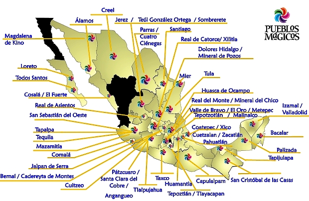
This map from the Tourism Secretariat (Sectur) shows Mexico’s 57 Magic Towns (as of September 2012):

Map of Mexico's 57 Magic Towns (September 2012). Credit: Sectur

Map of Mexico’s 57 Magic Towns (September 2012). Credit: Sectur

How many more Magic Towns will there be? Will the program continue after the new President takes office later this year? Watch this space!

Related posts:

Threats to the traditional Tarahumara way of life, part two

 Other  Comments Off on Threats to the traditional Tarahumara way of life, part two
Sep 132012
 

In the first part of this two-part article – Threats to the traditional Tarahumara way of life, part one – we looked at the threats to traditional Tarahumara life posed by alcohol, deforestation and the construction of new or improved roads in the Sierra Tarahumara (Copper Canyon) area.

In this part, we consider the impacts of drug cultivation, mining and tourism.

Drug cultivators and drug cartels

The incursion of drug cultivators seeking land for growing marijuana and opium poppies into the Canyon country has further marginalized the Tarahumara, sometimes labelled “Cimarones” (“Wild Ones”) by the newcomers. Drug cultivators have sometimes registered parcels of land as theirs and then ejected the Indians by force. Obviously, they choose the best available land, and their cultivation methods are designed to produce quick results, rather than sustainability.

Alvarado (1996) divides anti-drug policy into various time periods. First came an emphasis on catching those responsible, then came exhaustive efforts to eradicate the crops. Crop eradication has its own serious environmental downside, since it involves the widespread and indiscriminate use of aerially-applied herbicides, alleged to include Agent Orange, Napalm and Paraquat.

Alvarado’s study is an interesting analysis of the incredible, quickly-acquired wealth (and accompanying violence and corruption) that characterizes some settlements on the fringes of the Sierra Tarahumara. In some towns, for example, there are few visible means of economic support but the inhabitants are able to purchase far more late-model pick-ups than can their counterparts in major cities. Murder rates in these towns are up to seven times the Chihuahua state average. Violence even has a distinct, seasonal pattern, with peaks in May-June (planting time) and October-November (harvest time).

The levels of violence and injustice led Edwin Bustillos (winner of the 1996 Goldman Prize for Ecology) to change the focus of CASMAC, the NGO he directed, from environmental conservation to the protection of Tarahumara lives. In 1994, CASMAC was instrumental in stopping a 90-million-dollar World Bank road-building project that would have opened up still more of the Sierra Tarahumara to timber companies.

Mining

Besides deforestation and its resultant impacts, mining has had several other adverse effects on the Tarahumara and the local landscape. Mining activity has increased in the past decade as metal prices have been high and the federal government has encouraged foreign investment in the sector. Mining leads to a reduction in wildlife and to the contamination of water resources. The most damaging pollutants are heavy metals.

Tourism

Even tourism poses a potential threat. In the past decade, investments totaling 75 million dollars have been made to improve infrastructure (highways, runways, drainage systems, water treatment facilities, electricity) in the Copper Canyon region so that the area has the hotels, restaurants and recreational activities to handle six times the current number of visitors. The plan includes three remodeled train stations and a cable car that is already in operation. Sadly, the Tarahumara were not consulted. The plan essentially deprives them of some communal land with nothing being offered in exchange. Clearly, they are in danger of losing control over even more of their natural resources, especially since improved highways will benefit other groups such as drugs growers.

Anthrologist María Fernanda Paz, a researcher in socio-environmental conflicts at UNAM’s Regional Center for Multidisciplinary Studies, argues that these recent conflicts in the Copper Canyon region have stemmed from the federal government’s support for inflows of foreign capital, helped by modifications to the land ownership provisions enshrined in article 27 of the Constitution, changes made in 1992 during the administration of President Carlos Salinas de Gortari. In her view, the developers behind contentious projects first do everything possible to hide the project from public view until it is well advanced. Once people start to object, they then identify the community leaders and do everything possible to get them on their side. Before long, they have succeeded in creating a massive rift in the community, paying some very well indeed for their land, and others next to nothing.

Finally, the good news

The  Tarahumara recently (12 March 2012) won one of the greatest victories to date for indigenous peoples in Mexico. The Tarahumara (rarámuri) community of Huetosachi in the state of Chihuahua has now been recognized by Mexico’s Supreme Court as having long-standing indigenous territorial rights (but not formal ownership) that must be respected by the Copper Canyon Development Fund (Fideicomiso Barrancas del Cobre). This is truly a landmark victory. The Tarahumara have been guaranteed the right to be consulted over all Development Plans, and to select the benefits they will receive in exchange for any loss of ancestral territory. Finally, this juggernaut of a tourist development plan must respect the territories and natural resources of the Tarahumara.

This was truly David against Goliath. Huetosachi is a tiny settlement of only 16 families, about 10 km from where the main tourist complex is being built near the Divisadero railway station. The village has no water, electricity or health services.

The Copper Canyon Development Fund is now obligated to create a Regional Consultative Council allowing the villagers of Huetosachi and other settlements a say in the negotiations to decide what level of development is acceptable, and what the villagers expect in return. This council is expected to include representatives of 27 indigenous communities in the immediate area between Creel and Divisadero.

This landmark court decision could well be the first of many as indigenous groups elsewhere in Mexico fight their own battles against developers of various kinds. There could still be more court cases concerning the Copper Canyon region since it is widely expected that this initial success will lead to a legal challenge against the siting of the cable car. The villagers are also reported to be discussing how best to deal with water contamination allegedly resulting from existing hotels, and the possibility of a golf course being built on the canyon rim.

Sources:

  1. Alvarado, C.M. (1996) La Tarahumara: una tierra herida. Gobierno del Estado de Chihuahua. Somewhat repetitive academic analysis of the violence of the drug-producing zones in the state of Chihuahua, based in part on interviews with convicted felons.
  2. Merrill, W.L. (1988) Raramuri Souls – Knowledge and Social Progress in North Mexico. Smithsonian Institution, Washington D.C.
  3. Nauman, T. (1997) “Tala ilegal para la siembra de mariguana y opio en Chihuahua” p. 50 in El Financiero, May 12, 1997. Describes the Arareko project.
  4. Plancarte, F. (1954) El problema indígena tarahumara. INI. Mexico. Spanish language description published by National Indigenous Institute.
  5. Shoumatoff, A. (1995) “The Hero of the Sierra Madre” pp 90 – 99 of Utne Reader (July-August, 1995), reprinted from Outside (March 1995). An account of the determined efforts by Edwin Bustillos to prevent further environmental destruction in the Copper Canyon region.

Related posts:

The Guelaguetza, the major cultural festival of Oaxaca state

 Other  Comments Off on The Guelaguetza, the major cultural festival of Oaxaca state
Jul 282012
 

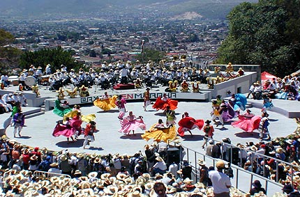
Oaxaca’s single biggest cultural event, held in the second half of July, has come to be known as the Guelaguetza, which is Zapotec for “offering” or “mutual help”. It celebrates the cultural and ethnic diversity of the state. This year’s edition (the 80th) of the Guelaguetza ends on Monday 30 July, so this is the final weekend.

A massive open-air amphitheater, seating 100,000 people, is a permanent fixture on the side of the Fortín hill which overlooks the north west quadrant of Oaxaca city. The original Aztec garrison (for the collection of tributes), known as Huaxyacac, was established by Ahuitzotl at the end of the fifteenth century on this very hill. Today, a massive statue of Benito Juárez (cast in Rome in 1891) stares out over the suburbs.

Guelaguetza

The Guelaguetza

The Guelaguetza may have its origins in Mixtec and Zapotec celebrations of their corn crop. Later, the festival was carried on by the Aztecs in honor of their corn god, Xilonen. Later still, in the eighteenth century, the Spanish Carmelite missionaries linked the festival to their own Christian rites for the Virgen del Carmen (16-24 July). The timing holds even more significance today since July 18 also marks the anniversary of the death of Juárez, a much-revered politician of humble, indigenous origin, who served five terms as president of Mexico in the nineteenth century.

Guelaguetza

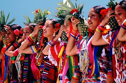
In the 1930s, the fiesta of the Guelaguetza took on its modern hybrid form, which includes a parade of stilt-walking “giants”. During the Guelaguetza, the Fortín hill is the scene for spectacularly colorful regional folkloric dances performed by several different ethnic groups (Mixtec, Zapotec, Trique, Popolac, Chootal, Chinantec, Mazatec, Mixe) from the seven main geographic regions of the state. The entire city comes alive with color. Color is everywhere from the beautifully hand-embroidered dresses and huipiles, to the food, to the paper streamers decorating the streets and to the mixture of merchandise sold on the sidewalks.

For travelers unable to visit in July, some central hotels, including the Camino Real, luxuriously housed in an architecturally-gorgeous former convent, and the Monte Alban opposite the cathedral, offer a weekly, scaled-down version of the Guelaguetza, year-round.

Want to read more?

Related posts:


Rocks and relief fieldtrip: Tequisquiapan and the Peña de Bernal

 Other, Teaching ideas  Comments Off on Rocks and relief fieldtrip: Tequisquiapan and the Peña de Bernal
Jun 212012
 

There is a close connection between geology and relief in many parts of Mexico. In this post we describe a one-day fieldwork excursion in the Tequisquiapan area of the central state of Querétaro that looks at this connection. The fieldwork is suitable for high school students but could easily be extended to provide challenges for college/university students.

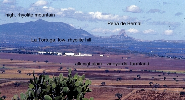
The fieldwork starts with a fieldsketch from near Tequisquiapan. Any suitable vantage point will do, provided it offers a clear view northwards to the very distinctive Peña de Bernal (seen in the background of the photo below). At this point, a simple line sketch should suffice to help students identify the following four different kinds of terrain:

  • flat or gently sloping plain, used for cultivation
  • low hills, with gently sloping sides, which look to be covered in bushes and cacti [scrub vegetation]
  • high mountains, with steeper slopes, also with no obvious signs of cultivation
  • the Peña de Bernal itself, a distinctive monolith with exceptionally steep sides

There is no need to identify any rocks or use any geological terms (students can add appropriate labels later!). Engage the students in a discussion about why there might be four different kinds of relief visible in this area, and how their ideas or hypotheses could be investigated further. Conclude the discussion by explaining that they are now going to look for evidence related to the idea that these four different kinds of relief are connected to significant differences in geology.

View looking north from "Las Cruces" near Tequisquiapan. Photo: Tony Burton; all rights reserved.

View looking north from "Las Cruces" near Tequisquiapan. Photo: Tony Burton; all rights reserved.

The next stop is a small roadside quarry on the flat area. The most accessible quarry many years ago was located a short distance south of Tequisquiapan on the east side of the highway, but any quarry on the flat land will serve to reveal the rocks that form the plain.

Roadside quarry, near Tequisquiapan. Photo: Tony Burton; all rights reserved

Roadside quarry, near Tequisquiapan. Photo: Tony Burton; all rights reserved

[Warning: Ensure that you park off the highway; when examining the rock in the quarry, avoid any overhanging sections, and do not do anything to cause slope instability or collapse].

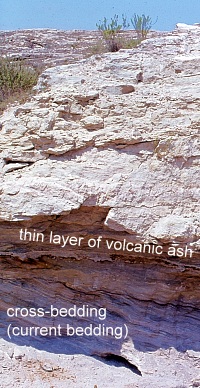
The rocks in the quarry are in layers (sedimentary) and very distinctive. The individual particles of the rock are rough to the touch and sand-sized, so this is some kind of sandstone.

Some layers are more or less horizontal, but in places successive layers are laid down at a much steeper angle. This is “current bedding” and indicates that the rocks were formed by water, perhaps where a river entered a lake. The individual particles in the rock are not well-rounded, so have not traveled all that far.

Within each major layer, the material shows signs of sorting, with fine material sitting on top of coarse material. In some places, the sandstone contains small pebbles, so this rock is a sandstone conglomerate. Small casts of fossil shells can be seen in places, further suggesting it is a sedimentary rock deposited in a former lake.

A very thin white layer is present (at about head height in the photo). This layer is totally different to the sandstone conglomerate. It is fine material that has been compacted. Given the volcanic history of central Mexico, this is almost certainly a thin layer of volcanic ash that covered older rocks before being covered in turn by the next layer of sediments.

With some guidance, students should be able to work most of this out for themselves! The last stage at this stop is to ask why this rock forms the flat land in the area, rather than the hills. (Answer: softer, weaker, less resistant, easier to erode, etc).

The next stop is to take a look at the rock forming the low hills. The highway between Tequisquiapan and Ezequiel Montes (see map) conveniently cuts through a low ridge at San Agustín. This affords an opportunity to take a close look at the rock forming that ridge. [Warning: Ensure that you find a safe parking spot, and take every precaution, since traffic along this highway can be heavy and very fast-moving]

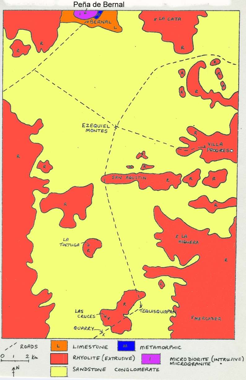
The rock at San Agustín is darker and much harder than the rock in the quarry. It has clear crystals in it, apparently arranged haphazardly. From its color (grey) and grainsize (fine), it is a rhyolite [a fine grained, acid igneous rock].  It is far more difficult to erode than the sandstone on the plain, so it forms upstanding ridges and low hills in the landscape.

From San Agustín, drive through Ezequiel Montes and on to the town of Bernal, one of Mexico’s “Magic Towns“. The next part is the most physically-challenging part of the excursion since it is necessary to climb at least part-way up the Peña de Bernal! [Warning: this is very steep in places, and climbing beyond the mid-way “chapel” is definitely not recommended]. Examining the rocks of the Peña de Bernal reveals that they are lighter in color than the rhyolite and fine-grained, but with larger crystals (phenocrysts) in some places. This rock must have cooled very slowly (or the phenocrysts would not have had chance to form) and this is an intrusive igneous rock known as microgranite. Eagle-eyed students should also find some other rocks while climbing the Peña de Bernal. In places, it is possible to find good specimens of a very hard, banded metamorphic rock that was formed when heat and/or pressure transformed pre-existing rocks. The banded rock is a gneiss [pronounced “nice”].

The presence of intrusive igneous rocks (formed underground) together with metamorphic rocks strongly suggest that the Peña de Bernal is an example of a volcanic plug. It represents the central part (and all that now remains) of a former volcano, whose sides, presumably composed of ashes and lava, have long since eroded away.

Conclusion:

After students have had chance to work most of this out for themselves, a look at the local geological map should confirm that their deductions are reasonable. As can be seen on the map below, the flat area is indeed an alluvial plain (sandstone), with low rhyolite hills and ridges in places, and higher rhyolite mountains in the background, with the distinctive Peña de Bernal made of igneous and metamorphic rocks at the northern edge of the map.

In this particular part of Mexico, as in many other areas, the link between geology and relief is very strong! Happy exploring!

Sketch map, Geology of the Tequisquiapan area

Sketch map, Geology of the Tequisquiapan area; click to enlarge

Related posts:

Jun 172012
 

Good news for Mexico’s coastline! The controversial Cabo Cortés mega-resort project in Baja California Sur, Mexico, has been cancelled, with President Felipe Calderón announcing that in “such an important area for the Gulf of California and the country … we should all be absolutely certain that [the project] will not cause irreversible harm”. However, Calderón did not rule out the possibility that a revised, more sustainable project might meet government approval.

As detailed in several previous geo-mexico.com posts, the Cabo Cortés project had been opposed by local residents, fishermen, environmental groups including Greenpeace and many academics:

The president of the Mexican Center for Environmental Law, Gustavo Alanis, hailed the government’s decision as “a triumph for conservation, environmental protection and nature.” He said that it is “a message in favor of legality and the rule of law in the environmental sphere” that would make clear to potential investors that they are welcomed as long as they respect nature and comply with existing environmental laws.

The geography of Tequisquiapan, a spa town in the state of Querétaro

 Other  Comments Off on The geography of Tequisquiapan, a spa town in the state of Querétaro
Jun 142012
 

The town of Tequisquiapan is an excellent place for geographers!

For one thing, it has a monument claiming to be The geographic center of Mexico. While this is hotly disputed, it is a fun place to start!

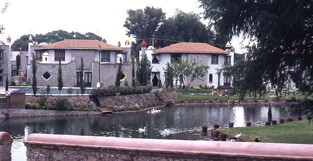
Tequisquiapan is an attractive spa town which has many hotels, restaurants and stores. It has grown substantially in recent years, attracting former Mexico City dwellers tired of the traffic congestion, smog and challenges of living in the big city. Mid-week, Tequisquiapan is largely deserted, with the air of a ghost town, waiting for revival. Revival occurs every weekend as the wealthier residents of Mexico City flee the city in search of clean air and blue skies. The town’s restaurants begin to fill and the discos gear up for action lasting into the early hours. Many of the weekenders now own second homes in Tequisquiapan.

Upmarket homes in Tequisquiapan. Photo: Tony Burton; all rights reserved

Upmarket homes in Tequisquiapan

Why is Tequisquiapan such an attractive choice for them? The key attractions (see Tequisquiapan, Querétaro: a delightful spa town)  are:

  • a small town atmosphere, with winding cobblestone streets, lined by attractive and neatly kept one-story buildings
  • the town boasts a dozen or more “three star” or better hotels, all with thermal swimming pools, and a multitude of handicraft shops and galleries
  • an 18-hole golf course, open to the public
  • a specialist handicrafts market, a lively permanent market and, on weekends, numerous small street stalls selling precious stones and jewelry (for enticing pictures, see Tequisquiapan, provincial Mexican charm  on MexConnect.com)
  • the town is small enough to walk around and bathed in sunshine virtually all year round
  • an annual cheese and wine festival in early summer
  • it is less than two hours by car from Mexico City
Annotated Google Earth image of Tequisquiapan area

Annotated Google Earth image of Tequisquiapan area

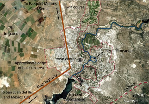
Anyone interested in urban geography will find that Tequisquiapan’s layout is quite unusual (for Mexico).  Some streets in the center of the town wander aimlessly rather than conforming to the traditional Mexican grid pattern. By way of comparison, a newer area of settlement across the highway (see image above) exhibits perfect grid pattern.

Bougainvillea-covered wall in Tequisquiapan

Behind the stone walls of the many fine hotels, the spa waters of Tequisquiapan offer their temptation. Why hike the streets when you can laze by a pool? The water is tepid rather than hot but very welcome, given the arid heat that envelops this area most of the year.

Towards the south-east, the town has grown around existing farmland, so homes surround an undeveloped core of agricultural land.

To the north, a former hacienda (Hacienda Grande) has been converted into a residential area built around a golf course. The irrigated fairways are strikingly visible on Google Earth.

Tequisquiapan is one of the few Mexican towns of its size and age to have a gated community in the downtown core, immediately off the main plaza.

Physical geographers won’t be disappointed either. Also near the center, upmarket houses have been built on the neck of a cut-off meander which has left an “island” with the river on either side. Floods on this river are now unlikely since it is controlled by the Centenario dam which has created a reservoir, Presa el Centenario, used for water sports.

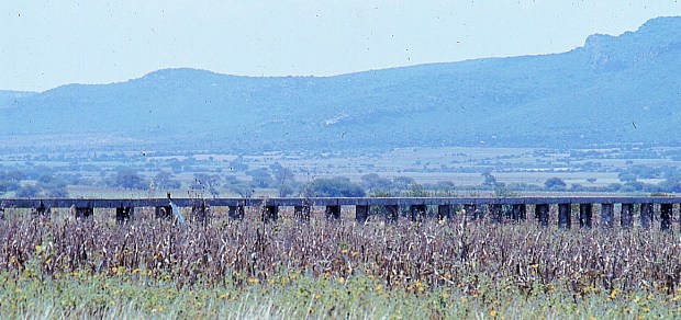
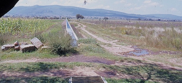
The flat valley floor around Tequisquiapan has become a rich farming area, particularly well known for its vineyards. A network of aqueducts and irrigation channels helps farmers overcome the vagaries of the annual dry season.


Aqueduct near Tequisquiapan. Photo: Tony Burton; all rights reserved.

Aqueduct near Tequisquiapan

The fact that this area has a pronounced dry season means that most local streams are intermittent; they run only for short periods during and immediately after the rainy season. The rest of the year, their channels are dry, providing a perfect opportunity for physical geographers to walk along them studying their features and landforms, without even getting their feet wet!

Irrigation channel near Tequisquiapan. Photo: Tony Burton; all rights reserved.

Irrigation channel near Tequisquiapan

On balance, given all these points of geographical interest, maybe Tequisquiapan is right to call itself the “geographic center” of Mexico after all!

Photos:

All photos in this post are by Tony Burton; all rights reserved.

Jun 072012
 

The Peña de Bernal, in the central state of Querétaro, is one of Mexico’s most distinctive geomorphosites. Geomorphosites are “landforms that have acquired a scientific, cultural/historical, aesthetic and/or social/economic value due to human perception or exploitation” (Panizza M., 2001). See Geotourism and geomorphosites in Mexico for a brief introduction to the topic.

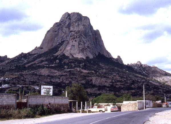
The Peña de Bernal is a dramatic sight, which only gets more imposing the closer you get. How high is the Peña de Bernal? We are unable to give you a definitive answer (it depends where you start measuring from) but claims of 350 meters (1150 feet) sound about right, assuming we start from the town.

Peña de Bernal. Photo: Tony Burton; all rights reserved

The Peña de Bernal. Photo: Tony Burton; all rights reserved.

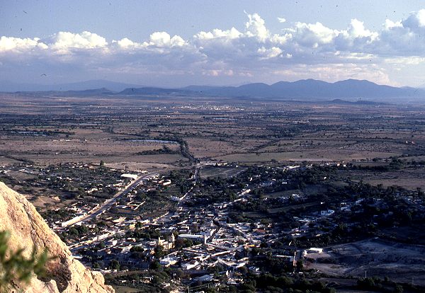
According to its Wikipedia entry, this is the “third tallest monolith in the world”, apparently only exceeded by the Rock of Gibralter and Sugarloaf Mountain in Rio de Janeiro. Others, including Melville King, have described it as the “third largest rock in the world”. These claims may (or may not) be exaggerated, but in reality it is definitely a very steep and tiring climb, even to reach the small chapel that has been built half-way up! The photo below is taken from this chapel, looking out over Bernal and the local farmland and vineyards.

View from the Peña Bernal, with the town of Bernal in the foreground.

View from the Peña de Bernal over the small town of Bernal. Photo: Tony Burton; all rights reserved.

How was the Peña de Bernal formed?

The most likely explanation is that this monolith represents the hardened magma (molten rock) from the central vent of a former volcano. This rock was much more resistant to erosion that the layers of ash and/or lava that formed the volcano’s flanks. Centuries of erosion removed the sides, leaving the resistant core of the volcano exposed as a volcanic neck. We will examine this idea in slightly more detail in a future post.

The town of Bernal

The town of San Sebastián Bernal is also well worth visiting. Having become a magnet for New Age types, it now boasts several decent restaurants, good stores and a range of hotels including high quality “boutique” hotels. Bernal was designated one of Mexico’s “Magic Towns” in 2005. To learn more about the town of Bernal and see some fine photos, we highly recommend Jane Ammeson’s article “The magic of Bernal, Querétaro: wine, opals and historic charm.

At the Spring Equinox (March 21), the town is invaded by visitors “dressed in long, white robes or gowns, and red neckerchiefs” who come seeking “wisdom, unity, energy and new beginnings”. (Loretta Scott Miller writing in El Ojo del Lago, July 1997).

How to get there:

From Mexico City, take the Querétaro highway (Hwy 57D) north-west to San Juan del Río. Then take Highway 120 past Tequisquiapan as far as the small cross-roads town of Ezequiel Montes. Turn left for about 11 kilometers, then right… and you’re there! Taking this route gives you glimpses of the Peña de Bernal from afar. Allow 2.0 to 2.5 hours for the drive.

Other geomorphosites worth visiting:

Mexico has literally thousands of geomorphosites. Among those described in previous posts are:


Mexico has more World Heritage sites than any other country in the Americas

 Other  Comments Off on Mexico has more World Heritage sites than any other country in the Americas
Mar 172012
 

The status of World Heritage site is a UNESCO (United Nations Educational, Scientific and Cultural Organization) denomination. The status is conferred on selected sites under the terms of “The Convention Concerning the Protection of the World Cultural and Natural Heritage”, adopted at UNESCO’s 17th General Conference in November 1972 and subsequently ratified by 189 member states.

Nations were invited to submit their proposals for any cultural or natural sites that they considered “of outstanding universal value”, and therefore eligible for inclusion on the World Heritage list. All proposals have to be approved by a special UNESCO World Heritage Committee.

The attraction of having a site classified as a World Heritage site is that it affords extra possibilities for obtaining technical co-operation in matters relating to conservation, for international assistance for research, training and equipment, and for emergency assistance in the event of damage due to specific natural or man-made disasters. All these sites are also valuable as cultural or environmental tourism destinations.
The list was first published in 1978, at which time it mainly featured European sites. Since then, regular additions have been made. As of March 2012, the list includes 936 locations in 153 member states. Of these sites, 725 are considered to have cultural significance, 183 to have natural importance and there are also 28 which share both cultural and natural value.

Mexico has 31 sites on the list, considerably more than any other country in the Americas. For example, the U.S. has 20 (together with a share of a 21st that straddles the border with Canada), Brazil 17 (as well as one jointly held with Argentina), Canada 14 (plus the joint U.S.-Canada site) and Peru 11.

Worldwide, only five countries have more World Heritage sites than Mexico. Four of these countries are in Europe: Italy, Spain, Germany and France. The other country is China.

Mexico’s existing World Heritage sites

Date added to list  – Name of site (state in brackets)

1987 Sian Ka’an biosphere reserve (Quintana Roo)
1987 Pre-Hispanic city and national Park of Palenque (Chiapas)
1987 Historic Center of Mexico City and Xochimilco (Mexico D.F.)
1987 Pre-Hispanic city of Teotihuacan (State of Mexico)
1987 Historic Centre of Oaxaca and archaeological site of Monte Alban(Oaxaca)
1987 Historic Centre of Puebla (Puebla)
1988 Historic town of Guanajuato and Adjacent Mines (Guanajuato)
1988 Pre-Hispanic city of Chichen-Itza (Yucatán)
1991 Historic Centre of Morelia (Michoacán)
1992 Pre-Hispanic city of El Tajin (Veracruz)
1993 Whale Sanctuary of El Vizcaino (Baja California)
1993 Historic Centre of Zacatecas (Zacatecas)
1993 Rock Paintings of the Sierra de San Francisco (Baja California)
1994 Earliest 16th-Century monasteries on the slopes of Popocatepetl (Morelos)
1996 Prehispanic town of Uxmal (Yucatán)
1996 Historic Monuments, Zone of Querétaro (Querétaro)
1997 Hospicio Cabañas, Guadalajara (Jalisco)
1998 Historic Monuments, Zone of Tlacotalpan (Veracruz)
1998 Archeological Zone of Paquimé, Casas Grandes (Chihuahua)
1999 Historic fortified town of Campeche (Campeche)
1999 Archaeological Monuments, Zone of Xochicalco (Morelos)
2002 Ancient Maya City and biosphere reserve of Calakmul (Campeche)
2003 Franciscan Missions in the Sierra Gorda (Querétaro)
2004 House and Studio of Luis Barragán (in Mexico City)
2005 Islands and protected areas of the Gulf of California
2006 Agave landscape and old tequila-making facilities in Amatitán, Arenal and Tequila (Jalisco)
2007 Central University City Campus of the Universidad Nacional Autónoma de México (UNAM) (Mexico City)
2008 Monarch Butterfly Biosphere Reserve (Michoacán and State of México)
2008 San Miguel de Allende and the Sanctuary of Jesús de Nazareno de Atotonilco (Guanajuato)
2010 Camino Real de Tierra Adentro, the 2,900 kilometer historic route linking Mexico City to Santa Fe in New Mexico
2010 Prehistoric caves of Yagul and Mitla in the Central Valley of Oaxaca

Mexico’s proposed World Heritage sites:

Mexico has formally proposed numerous additional sites for World Heritage Status. The applications are coordinated by the National Anthropology and History Institute (Instituto Nacional de Antropología e Historia), better known by its Spanish acronym INAH. Proposals include:

1.  Historic town of San Sebastián del Oeste (Jalisco)
2. Tule (ahuehuete) tree of Santa María del Tule (Oaxaca)
3. Zempoala aqueduct, a project of Padre Tembleque (Hidalgo and State of Mexico)
4. Monterrey’s old industrial facilities, including a foundry, brewery and glassworks (Nuevo León)
5. The Aguascalientes railroad station and residential complex (Aguascalientes)
6. The Museo Casa Estudio Diego Rivera and Frida Kahlo (Mexico D.F.)
7. Ludwig Mies van Der Rohe and Félix Candela’s industrial buildings, including the offices of Bacardí y Compañía (State of Mexico)
8. Historic city of San Luis Potosí (San Luis Potosí)
9. Chapultepec Woods, Hill and Castle (Mexico D.F.)
10. Historic town of Alamos (Sonora)
11. Pre-Hispanic city of Cantona (Puebla)
12. The church of Santa Prisca in Taxco (Guerrero)
13. The former Jesuit college in Tepotzotlán (State of Mexico)
14. The churches of the Zoque province (Chiapas)
15. The pre-Hispanic city of Chicomostoc-La Quemada (Zacatecas)
16. Archaeological monuments, zone of Mitla (Oaxaca)
17. Cuatrociénegas flora and fauna reserve (Coahuila)
18. Franciscan convent and Our Lady of the Assumption cathedral in Tlaxcala (Tlaxcala)
19. Historical town of the Royal Mines of Cosala (formerly known as the Royal of the Eleven Thousand Virgins of Cosala) (Sinaloa)
20. Huichol Route used by Huichol Indians through their sacred sites to Huiricuta (San Luis Potosí) (sometimes spelt as Wirikuta)
21. The former textile factory La Constancia Mexicana and its housing area (Puebla)
22. The Lacan-Tún—Usumacinta region (Chiapas)
23. The Banco Chinchorro Biosphere Reserve(offshore in Quintana Roo)
24. The El Pinacate and the Great Altar Desert Biosphere Reserve (Sonora)
25. The Selva El Ocote Biosphere Reserve (Chiapas)
26. Sotáno del Barro, a 450-meter-deep sinkhole (Querétaro)
27. Tecoaque archaeological site (Tlaxcala)
38. Valle des Cierges, including Montevideo Canyon (Baja California)

Not all sites are accepted. For instance, Mexico’s rejections include the Lake Pátzcuaro region, in the state of Michoacán, and the El Triunfo nature reserve.

Mexicans are justly proud of their nation’s history and culture, and have always been prepared to share them with visitors. By getting so many locations on UNESCO’s list of World Heritage sites, the country is reaffirming its commitment to trying to ensure that its cultural and natural treasures are well protected for future generations. Any of the places mentioned in this article is well worth visiting and exploring. In some cases, it is possible to construct fascinating “itineraries” combining several of the sites in a single trip.

Bear in mind, though, that there are also numerous attractions not yet listed as World Heritage sites that probably deserve to be included in the future. For starters, how about Paricutin Volcano, one of only a handful of new volcanoes to appear on land in historic times? Or how about the Copper Canyon region, with its grandiose scenery and indigenous Tarahumar population?

For more information:

Related articles:


Mar 072012
 

Artificial reefs are usually created by sinking a ship (after it has been thoroughly cleaned to prevent any toxic substances from entering the marine environment) or some other massive metal or concrete structure. Marine sediments gradually collect in, on, and around the objects, which are rapidly colonized by marine life. For rapid reef building, individual corals are sometimes transplanted onto the new structures.

The latest artificial reefs in Mexico are works of art. Jason deCaires Taylor, a British artist and dive instructor, has built an extraordinary collection of concrete sculptures and then carefully positioned them underwater in a marine park near Cancún, Mexico’s most popular tourist resort. The objective was to create an underwater “museum”, which divers and snorkelers can explore, while simultaneously providing a variety of structures for sea-life to inhabit.

One of the more remarkable sculptures is entitled “The Archive of Lost Dreams”. It features a librarian (pet dog at his feet) caring for and cataloging a collection of messages in bottles into “hopes”, “fears”, etc.. Another of the sculptures is a full-size model of the iconic Volkswagen Beetle.

The art-park, begun in 2009, is planned to house 400 sculptures in all and is billed as the largest underwater art museum in the world.

Another work now under construction is modeled on the ears of every child in a grade school class; it will be fitted with a hydrophone to enable marine biologists to analyze reef sounds (New Scientist, 17 December 2011).

Marine grade concrete is used for the exhibits, which are built to withstand a Category 4 hurricane. It is anticipated that hard and soft corals will eventually cover the sculptures, partially making up for the damage done to natural reefs by storms, tourists and boats, and reducing visitor pressure on the natural reefs. The natural reef off the coast of Quintana Roo, is part of the Mesoamerican Reef, the longest coral reef in the northern hemisphere and the second largest coral reef in the world. It is under constant pressure from coastal developments such as new hotels and cruise ship berths, as well as from climate change. The marine park near Cancún is visited by about 800,000 tourists a year.

The artist may think his idea is laudable, but not everyone is convinced. Critics argue that art works are not a good fit with the natural world, and why try to improve on nature? In addition, if artificial reefs are not carefully sited and well managed, they may be torn loose during storms and then cause extensive damage to any nearby natural reefs.

Related posts:

Mar 052012
 

In a previous post–The development of Huatulco, the tourist resort in southern Oaxaca–we looked at how the tourist resort of Huatulco was created by Mexico’s National Tourism Development Fund (Fonatur) on a series of small bays in the state of Oaxaca. Clearly, this development was very much “top-down” and it has been widely criticized from many distinct points of view. From a geographical perspective, the most important criticisms have arisen from researchers such as Evelinda Santiago Jiménez and David Barkin, co-authors of a short article entitled “Local Participation and Sustainability: a study of three rural communities in Oaxaca, Southern Mexico.”

Their view is that government programs, such as Huatulco, “are generally conceived for areas where there are resources that can be transformed into commodities”. In the case of Huatulco, this means that “access to public services, such as potable water, is designed to satisfy the demands of the visitors and affluent local service providers, while the majority suffer from inadequate supplies and must accept the conditions imposed on them.” Santiago Jiménez and Barkin see this as “a new form of colonization, implemented in the name of modernity to expropriate communal lands with minimal guarantees and compensation; a process of excluding local peoples; a way to subordinate the local inhabitants…; and a process than causes harm to the environment.”

The article by Santiago Jiménez and Barkin appears in a book entitled Nature’s Revenge: Reclaiming Sustainability in an Age of Corporate Globalization (University of Toronto Press/Garamond 2006). This book, which in its own words, “proposes a radical definition of sustainability, reclaiming the word from the rhetoric typically used by corporations and governments to facilitate unrelenting economic growth and the notion of ‘business as usual'”, is well worth reading.

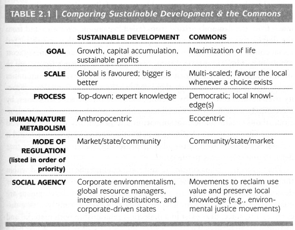
The authors argue for adopting a “commons”-based approach, where the term “commons” is understood to include not only the idea of commonly-held or shared rights and property (such as water, air, soil) but also the “social commons” comprised of community knowledge and culture. In stressing “the complex interrelations that exist at local, regional, national, continental, and global levels of human organization”, the authors critique advocates of “localism” and argue that “there can be no simple solution confined to one particular scale of action.”

A table in Chapter Two (Who cares about the Commons? by Josée Johnston) summarizes the key differences between sustainable development (as used by corporations and governments) and the commons-based approach favored by the book’s authors:

Table 2.1 of "Who cares about the Commons" by Josée Johnston.
Table 2.1 of “Who cares about the Commons” by Josée Johnston.

It is an example of this commons-based approach that Santiago Jiménez and Barkin examine in their chapter. They analyze an alternative, locally initiated project, based on the Integrated Development of Natural Resources (Administración Integral de los Recursos Naturales, AIRN), which stands in sharp contrast to Fonatur’s “top-down” development model. The AIRN approach recognizes that local communities have a symbiotic relationship with their surrounding natural environment that is “crucial for mutual survival”. It also recognizes that the community-environment links are dynamic, not static, and will change or evolve with time as the community develops.

AIRN proposals aim, essentially, to speed up this development process, helping to find new productive projects for the communities while managing ecosystems effectively and sustainably. The success of AIRN development projects relies on an active participation by the local community to identify issues, opportunities and ways to progress. It is crucial that the local people are equal partners in the decision-making process.

In the Huatulco area, the Center for Ecological Support (Centro de Suporte Ecológico, CSE), an NGO, adopted an AIRN approach to devise appropriate strategies to reverse the damage done to water resources by the construction and expansion of Huatulco tourist resort, which had destroyed forest cover, reduced infiltration and abstracted water from the aquifer that underlies the Copalita River. The CSE proposed a reforestation program to actively regenerate (not just protect) the forests throughout the basin, including parts of the Southern Sierra Madre (Sierra Madre del Sur). At the same time, the CSE helped local inhabitants to explore new (alternative) sources of employment and income based in their communities, which offered them a viable option to abandoning their land and accepting menial low-paid  jobs in the tourist resort or elsewhere.

Santiago Jiménez and Barkin looked at three small villages that had participated in the AIRN proposals made by the CSE: Santa María Xadani, Santa María Petatengo and El Achiote. Each village had participated in different ways, and with varying degrees of success. Close familial ties in Petatengo, for example, ensured more community support than in Xadani where internal divisions reduce social cohesion. El Achiote is a small “rancho” of 14 families, all of whom participated in the reforestation project. The families also combine to carve and paint the colorful Oaxacan whimsical wooden figures known as “alebrijes”. The settlement gained electricity service in 2000 and telephone service in 2001. Sadly, a combination of circumstances led to many local inhabitants migrating away from the area in search of better incomes and the CSE was forced to suspend its operations.

The authors point out that development plans have to take account of three very different concepts of time. The local communities in this region view time as somewhat flexible, preferring to make decisions by consensus, rather than in order to meet any deadline. Organizations providing funding for projects see time in terms of deadlines and financial commitments. Local and state governments view time in terms of political cycles, with a project having more chance of success if it is launched early on in an administration’s term. Santiago Jiménez and Barkin also emphasize the importance of projects having an effective mediator (as the CSE proved to be) “capable of balancing the rhythms of Western culture, of nature, and of traditional culture”.

Mexico badly needs more examples of successful mediators, particularly where large scale tourism projects are concerned.

Related posts:

Drug war death trends in areas of Mexico of interest to foreign tourists and retirees

 Other  Comments Off on Drug war death trends in areas of Mexico of interest to foreign tourists and retirees
Mar 022012
 

Non-Mexicans are far more interested in some parts of Mexico than others. These areas of interest may be well-known tourist destinations, have thousands of expatriate residents or are located on major expatriate travel routes. Mexico’s major cities, which are also of interest to foreigners, were discussed in a previous post. This post focuses on 24 municipalities of less than 500,000 population. (These are listed alphabetically in the table linked to at the end of the post.)

Drug war death rates vary enormously among the 24 communities. Data released by the Office of the President [note 1] indicate that some of these municipalities have extremely high drug war death rates. The number of deaths in Zihuatanejo went from 16 in 2010 [note 2] to a startling 90 in the first nine months of 2011. This results in a rate of 115 deaths per 100,000 population/yr or over seven times the national average of 15.3 [note 3]. This places Zihuatanejo among the 20 most dangerous communities in Mexico (see earlier post) along with the other famous Guerrero beach resort of Acapulco.

Other dangerous municipalities listed in the table are Tepic, Nayarit at 69 (4.5 times the average); Mazatlán at 58 (3.8 times the average) and Nuevo Laredo at 50 (3.3 times the average). Thousands of expatriates live in Mazatlán while thousands drive through Tepic and Nuevo Laredo. The temporal trends in these dangerous cities vary widely. Between 2010 and 2011, the rate for Zihuatanejo went up 650% while Nuevo Laredo’s increased by 67% and Tepic edged up 14%. The rate for Mazatlán was down 20%.

The most worrisome trend is the very rapid drug violence increase in Veracruz State. From 2010 to 2011 the death rate for Xalapa went up 1,066%. In 2010 there were a total of 15 drug war deaths in Xalapa, Boca del Río and Veracruz City combined; but in the first nine months of 2011 this went up to 284. It remains to be seen if this dreadful trend will continue into 2012 and beyond.

Other cities in the table with rates significantly above the national average include Nogales with a rate of 28, down 68% from 2009. The rate for Playas de Rosarito (Baja California) was up 41% to 28, nearly double the average of 15.3. Matamoros’ rate increased 13% to 20 while Cuernavaca’s was down 49% to 19.

The death rates in towns near Lake Chapala varied markedly. The rate for Ixtlahuacán de los Membrillos dropped from 34 in 2010 to 16 in 2010, but was still above the national average and twice the rate of neighboring Chapala. The rate for nearby Jocotepec of 13 was between the other two. Though local media suggest a growing drug violence problem in these three communities, the actual number of deaths dropped from 24 in 2010 to 12 in 2011. The death rate for the three communities dropped from 34% above average in 2010 to 33% below average in 2011.

The great news is that three of communities in the table—Bahia de Banderas, Guanajuato and San Miguel de Allende—had zero drug war deaths in the first nine months of 2011, compared to 27 in 2010. Bahia de Banderas, in Nayarit just north of Puerto Vallarta, is of particular interest because it had 19 deaths in 2010. If this precipitous drop is not a statistical anomaly it represents a major anomaly because the number of deaths in the adjoining community of Puerto Vallarta almost doubled from 15 in 2010 to 28 in 2011; furthermore there were 196 deaths in nearby Tepic.

Several tourist areas had drug war death rates less than a sixth the national average. These include Ensenada, La Paz and Los Cabos on the Baja Peninsula as well as Oaxaca City. Not far behind was Playa del Carmen with a rate about one quarter of the average. These data suggest that tourists worried about drug violence and seeking a beach resort vacation might lean toward Baja California Sur or the Maya Riviera instead of Acapulco, Zihuatanejo or Mazatlán.

Notes:

[1] “Van mas de 47 mil muertos por nacroviolencia: PGR”, El Universal, 12 January 2012, http://www.eluniversal.com.mx/notas/822078.html.

[2] “Mexican drugs war murders data mapped”, Theguradian, posted by Johanna Tuckman, Jan 14, 2011. http://www.guardian.co.uk/news/datablog/2011/jan/14/mexico-drug-war-murders-map. For data see: http://www.google.com/fusiontables/DataSource?dsrcid=393962.

[3] The rates for 2011 were adjusted because data are available for only the first nine months of the year.

The geography of the 2011 Pan American Games (Juegos Panamericanos)

 Mexico's geography in the Press  Comments Off on The geography of the 2011 Pan American Games (Juegos Panamericanos)
Jan 022012
 

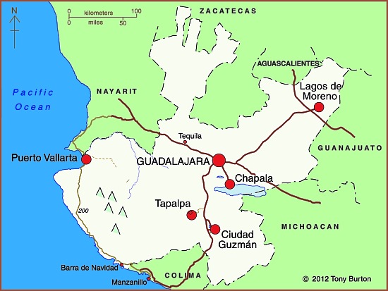
The XVI Pan American Games were held from October 14–30, 2011 in Guadalajara (Jalisco) with some events held in outlying locations such as Ciudad Guzmán, Puerto Vallarta, Lagos de Moreno and Tapalpa. They were the largest multi-sport event of 2011. Some 6,000 athletes from 42 nations participated in 36 sports. The largest contingents of athletes (more than 500 in each case) came from host nation Mexico, Brazil, Argentina, the USA, Cuba and Canada.

Guadalajara is Mexico’s second city, a metropolitan area of almost five million people, the industrial and commercial hub of a region that is considered quintessentially Mexican, home to charrería (Mexican horsemanship), jarabe tapatío (Mexican hat dance), mariachi music, and tequila, the national drink.

This post looks at the impacts of the Pan American Games on the local economy.

How much investment was required to host the games?

The original budget for the Games was $250 million (dollars), but this ballooned to about one billion by the time of the Opening Ceremony. The security budget was $10 million, to pay 10,000 municipal, state and federal police, as well as elements from the Mexican army and navy, to patrol the streets surrounding the venues during the games.

How many visitors attended the Games?

The State Tourism Secretariat expected 800,000 visitors and spending of $75 million (dollars). Some government spokespersons claimed that between 1 and 1.5 million attended the games. However, a study released by the Guadalajara Chamber of Commerce found that 454,148 visitors came to Guadalajara during the games (305,177 from the state of Jalisco, and 148,971 from elsewhere). 83% (424,354) of visitors came “specifically for the Games”.

How many jobs were created?

The build-up to the games created some 50,000 new jobs. In addition, more than 6,000 volunteers, mainly students, were employed during the games.

How much were the media and TV rights worth?

1,300 media representatives attended the games. More than 750 television hours of sports were broadcast, with global digital media company Terra broadcasting the games live in 13 simultaneous high-definition online channels. The TV rights were worth $50 million.

How many sports venues were used?

There were 32 different venues used during the games. Billions of pesos were spent building 19 impressive new sports stadiums and complexes. Thirteen existing sports arenas in the Guadalajara metro area were rebuilt or extensively refurbished. The opening and closing ceremonies for the Pan American Games were held in a 48,000-seat local soccer stadium, the Omnilife Stadium (Estadio Omnilife), built in 2010 for the Guadalajara “Chivas” soccer team.

Facilities built specifically for the games included an iconic Aquatics Center (Centro Acuático), sponsored by Scotiabank, with two Olympic-size pools and seating up to 3,500 spectators, and a state-of-the-art gymnastics venue, sponsored by Nissan.

2011 Pan American games venues in Jalisco, Mexico

2011 Pan American games venues in Jalisco, Mexico

How did the games help regional development?

Several sports events were held at sites well away from the Guadalajara metro area. This helped promote a regional profile for the games. The five locations involved (see map) were:

  • Puerto Vallarta (beach volleyball, open water swimming, triathlon, sailing)
  • Lagos de Moreno (baseball)
  • Ciudad Guzmán (rowing, canoeing)
  • Chapala (water skiing)
  • Tapalpa (mountain biking)

How much did visitors to the games spend?

Local businesses reported sales up 7% during the period of the Games. The total games-related spending by visitors was estimated at $210 million (dollars). Hotel occupancy rates for the period of the games rose from 58.3% in 2010 to 76.4% during the games. The rate was 97% for the 5-star hotels in Guadalajara and Puerto Vallarta.

Even so, according to a local newspaper (The Guadalajara Reporter), local business owners were “underwhelmed” by the Pan American Games’ impact. Restaurants, bars, clubs, taxis and travel agencies all received fewer customers than anticipated. Local business owners said that “very few foreign tourists came for the games, while most spectators at the events were local citizens, athletes and their families, journalists and other games-affiliated personnel.” Business owners in Puerto Vallarta were reported to be “angry at the lack of publicity for the destination”.

Problems with the Athletes Village

The Pan American Athletes Village (Villa Panamericana) was built one kilometer outside Guadalajara’s western ring-road (Periférico) to house all 6,000 participants. The location is conveniently close to the Omnilife Stadium, site of the opening and closing ceremonies.

The Athletes Village has three-bedroom apartments, a central plaza, restaurant, gym, discotheque, chapel, swimming pool, theater and health clinic. The original plan was for the Village apartments to be sold after the Games for between $90,000 and $250,000 (dollars) each. However, the fate of the Athletes Village is still uncertain, because residents of the nearby (and long-established) Rancho Contento subdivision have taken the owners to court,  demanding that the Athletes Village be demolished since it has already caused irreparable damage to the local ecosystem.

Apart from some issues of housing density in this area, the main concern is that the village has inadequate provision for sewage. After the Games ended, local newspapers reported that faulty treatment plants had resulted in sewage being pumped out of the village on to land inside the nearby Primavera Forest biosphere reserve. Apparently, two of the Village’s treatment plants “collapsed” under the volume of wastewater generated, and partially-treated sewage had collected as open ponds. It is unclear if the sewage contaminated local subsoil and streams. After the Games, city officials closed the plants and fined the Athletes Village administrators. The administrators claim that the plants and Village had been designed to accommodate only 2500 to 3000 athletes, not the 6000 participants that were later housed there.

Conclusion

The lasting legacy of the games is a number of new hotels in Guadalajara, including hotels in the Westin and Riu chains, and a number of new or upgraded sports venues. In addition, many roads were repaved and numerous other beautification projects have helped improve Guadalajara’s urban fabric and infrastructure. The city’s main exhibition space (Expo Guadalajara) and the international airport have both been expanded.
The first obvious benefit of these improvements has been that the city (and its new Aquatics Center) have been chosen to host the 2017 World Swimming Championships.

Related posts:

Dec 172011
 

Mexico’s Magic Town (Pueblo Mágico) designation is given to inland destinations that offer a complementary tourism based on historic and cultural attributes. Mexico’s federal Tourism Secretariat has announced there will be 52 Magic Towns by 2012, when the promotional program is due to end. Mexico currently has 48 Magic Towns. Since our list earlier this year (see Mexico adds three more Magic Towns to its list) four more towns have been added to the select club. All are well worth visiting!

Magic Town #45: El Oro de Hidalgo (State of México)

The small town of El Oro (population about 6,000) is in the western part of the State of México, close to the state limit with Michoacán. It is a former mining town which was largely abandoned when its mineral reserves (gold) ran out. It has several very attractive old buildings and a state Mining Museum.

Magic Town #46: Xico (Veracruz)

Xico is located in the central part of Veracruz state, about 25 km from the state capital Xalapa, in an agricultural area known for tropical fruits and coffee. In the vicinity are the Texolo waterfalls, where the movie “Romancing the Stone” was filmed. Xico holds a lively annual fair every July, complete with colorful sawdust carpets and bull-running.

Magic Town #47: San Sebastián del Oeste (Jalisco)

San Sebastián del Oeste is another enchanting old mining town, founded in 1605, located in the rugged mountains which separate the interior valleys of central Jalisco from the Pacific Coast, at an altitude of 1500 meters (5,000 feet) above sea level. Local mines yielded a fortune in gold, silver and copper, before the town lapsed into quiet lassitude once the ore reserves were exhausted. It is amazing to think that all the salt used in the silver processing had to be brought on horseback over the mountains from a tiny primitive port called Puerto de las Peñas, at the mouth of the River Cuale, a port now known as… Puerto Vallarta!

San Sebastián del Oeste

San Sebastián del Oeste

Magic Town #48: Xilitla (San Luis Potosí)

The town of Xilitla is set in luxuriant rainforested mountains in San Luis Potosí. It is best known as the site of Las Pozas, Edward James’ surrealist jungle fantasy. To read more about Xilita, try the following articles on MexConnect:

Related posts:

Nov 142011
 

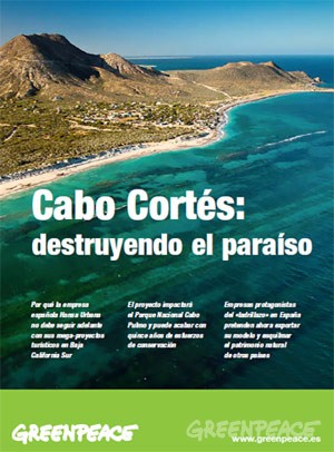
A few months back, we wrote of the conflicts surrounding the proposed tourist mega-development near Cabo Pulmo. The controversial plans for Cabo Cortés involve building on the virgin sand dunes, and will undoubtedly have adverse impacts on the small village of Cabo Pulmo and the ecologically-sensitive Cabo Pulmo National Marine Park and its coral reef.

Later, we followed up with an in-depth look at how the establishment of a Cabo Pulmo Marine Park had led to an astonishing recovery of the area’s biodiversity:

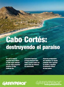
Cover of Greenpeace's position paper on Cabo Cortés

"Cabo Cortés: destroying paradise" (Greenpeace)

This story, which essentially pits mass tourism against ecotourism, continues to attract lots of media attention. The latest major article is Plans for resort in Mexico ignite concern about reef, published in The Washington Post. The article looks at the Spanish companies involved in the ownership and construction of the proposed resort and quotes the opinion of local people who hope that the economic crisis in Europe will put an end to their grandiose plans.

The Spanish firms involved are “ailing Spanish development conglomerate” Hansa Urbana, which bought the meg-development site in 2007, and a  savings bank called CAM (Caja de Ahorros del Mediterraneo), which lent Hansa millions of dollars.

Later, Hansa gave CAM the property in exchange for having its debt wiped clean. CAM has since been bailed out to the tune of $3.8 billion by the Bank of Spain, in which the Spanish government has a controlling interest. The Bank of Spain plans to auction CAM, but only after the upcoming Spanish elections.

As a result, and as the Washington Post article makes clear, “environmental activists are not even sure who controls the resort project anymore.”

Mexico’s federal Environment and Natural Resources Secretariat (Semarnat) originally gave Spanish firm Hansa Urbana the green light to begin construction, but now say that construction can only begin if the developers can prove that the reef will remain unharmed.

Mexican authorities are reported to be consulting with “expert marine biologists and U.N. officials”:

  • Misión conjunta de la UNESCO y Ramsar visitará Cabo Pulmo la próxima semana
  • La UNESCO visitará Cabo Pulmo

The government has set a deadline of January 2013 for the submission of a detailed report showing that construction will not cause any environmental damage to the Marine Park.

The deadline comes only a month after President  Calderon leaves office, which, as many locals realize, could be very unfortunate for the future welfare of the reef and local ecotourism activities.

Mexico adds three more Magic Towns to its list

 Mexico's geography in the Press  Comments Off on Mexico adds three more Magic Towns to its list
Oct 272011
 

Mexico’s Magic Town (Pueblo Mágico) program seeks to promote inland destinations that offer a complementary tourism based on historic and cultural attributes. The federal Tourism Secretariat has announced there will be 52 Magic Towns by 2012, when the promotional program is currently due to end. As many as 70 towns are reported to be seeking accreditation as Magic Towns. Some of these applicants are likely to join similar promotional groupings such as “Pueblos con Encanto” (Towns with Charm) and “Pueblos Señoriales” (Noble Towns).

Mexico currently has 44 Magic Towns:

The three latest towns to be added to the list are:

Magic Town #42: Mineral del Chico (Hidalgo)

Mineral del Chico is a small town (population 6700 in 2005; altitude 2351 m) at the entrance to the El Chico National Park in Hidalgo. The National Park, with its forests, mountains and waterfalls, is much better known than the town itself. This was the one of the earliest forested areas to be officially protected in Mexico. It was declared a Forest Reserve in 1898 and became a National Park in 1922.

Magic Town #43: Cadereyta (Querétaro)

The designation of Cadereyta as a Magic Town creates a great multi-day tourist trip including two other Magic Towns: Bernal and Jalpan de Serra. Cadereyta is known for its noisy and ebullient Holy Week (Semana Santa) processions, a tradition said to date back to the 18th century. The town has several interesting churches and two genuine colonial treasures. The gilded retable of the church of San Pedro and San Pablo has to be seen to be believed.

  • Tourism attractions of Cadereyta
  • Two colonial treasures of Cadereyta

Magic Town #44: Tula (Tamaulipas)

Close to the northern border, Tula, founded in 1617, is the oldest still-inhabited settlement in the state of Tamaulipas. The town has several colonial buildings but is best known for making elaborate leather jackets (cuera tamaulipeca), first designed in the 1950s.

These three latest newcomers all have their attractions, but, at least in my humble opinion, are not in the same league in terms of their historical and tourist interest as most previously-designated Magic Towns.

Related posts:

Veracruz: one of Mexico’s most diverse states

 Other  Comments Off on Veracruz: one of Mexico’s most diverse states
Oct 242011
 

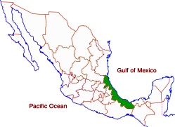
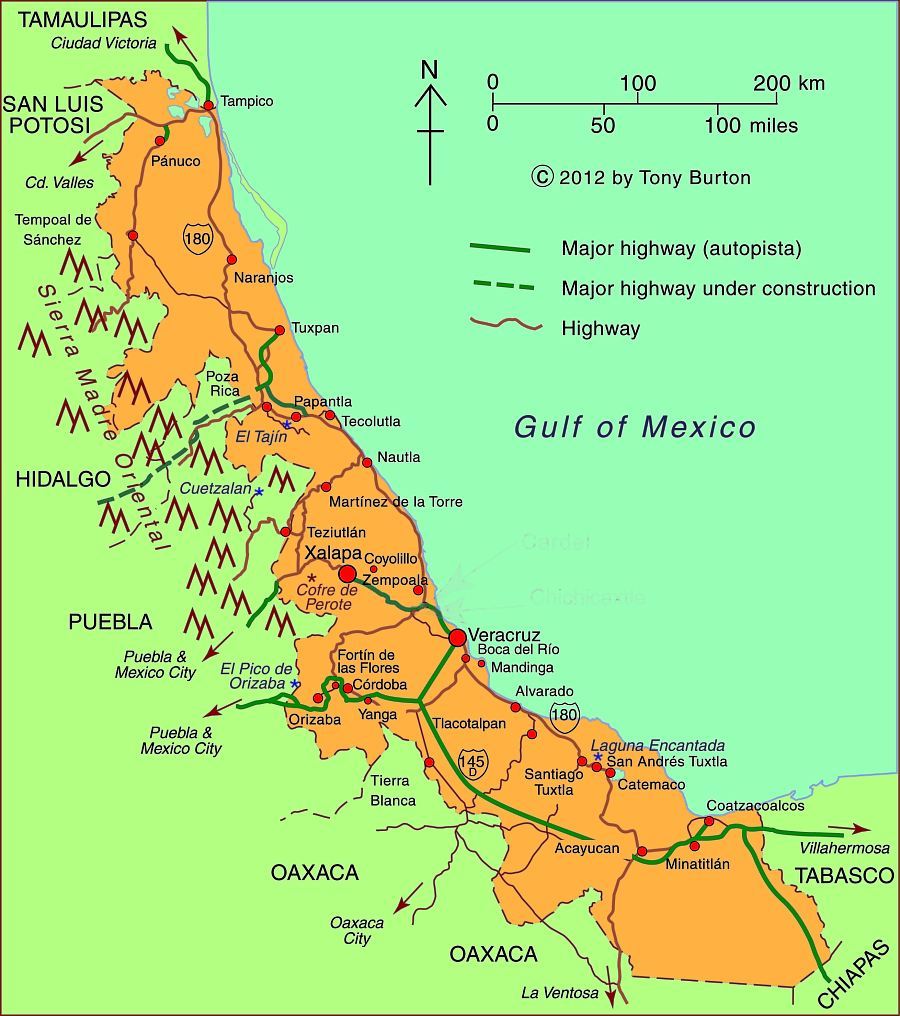
Veracruz, one of Mexico’s most important and interesting states, is a narrow strip of land stretching for 650 kilometers (over 400 miles) along the Gulf of Mexico. The topography ranges from a narrow coastal plain to very high mountains on its western border including Mt. Orizaba, Mexico’s highest peak at 5,610 meters (18,406 ft.).

The relief helps to funnel migrating birds into a narrow band across the state:

Veracruz which is one of the rainiest states has three of Mexico’s five largest rivers: the Panuco in the north and the Papaloapan and Coatzacoalcos rivers in the south. Its varied climate and ecosystems mean enormous biodiversity, including species of insects, birds and plants that exist nowhere else on earth. These species are protected in 31 protected areas including three national parks. Previous posts describe the fabulously beautiful Las Tuxtlas Biosphere Reserve and the mysterious Laguna Encantada.

With over 7.6 million residents, Veracruz trails only the State of Mexico and the Federal District in population. While the state is over one-third rural, it has several major metropolitan areas. The state capital is Xalapa (809,000). Other major cities include the industrial twin cities of Coatzacoalcos (234,000) and Minatitlán (356,000) in the extreme south, and the port city of Veracruz (703,000) in the center. The north of the state is served by the port city of Tampico (803,000) on the north bank of the Panuco River in the neighboring state of Tamaulipas.

One of the most interesting towns is Yanga, which was established around 1570 by escaped slaves lead by Gaspar Yanga. The town, the first African-ruled settlement in the New World, successfully resisted efforts by the colonial government to recapture it and its residents. Today, Gaspar Yanga is considered a national hero. It is interesting to note that Negroid features are apparent on the ancient 3,500 year old Olmec carved stone heads found in southern Veracruz. The state is home to numerous indigenous groups including the Nahuas, Huastecos, Otomis, Totonacs.

Map of Veracruz state, Mexico; all rights reserved.

Map of Veracruz state, Mexico; all rights reserved. Click to enlarge.

There are two UNESCO-designated World Heritage sites in Veracruz: the Pre-Hispanic city of El Tajin and the Historic Monuments of the Zone of Tlacotalpan.

Veracruz is one of Mexico’s poorer states. Mostly as a result of its very large rural, agricultural and indigenous populations, Veracruz ranks in the bottom third in most socioeconomic indicators such as production/person, percent living below the poverty level, human development index, literacy, infant mortality, life expectancy and marginalization. On the other hand, these indicators for the major cities are above the national averages.

Veracruz is second in total agricultural production behind only Jalisco. It produces more than half of the country’s sugar cane and oranges and also leads in mangoes and other citrus fruits. It is also a major producer of coffee, beef, pork, dairy, chicken, corn, beans, bananas, tobacco, coconuts, vegetables and vanilla.

Petroleum is extremely important. Most of the oil production is in northern Veracruz while the southern cities of Coatzacoalcos and Minatitlán are noted for their chemical and petrochemical industries.

Veracruz is also famous historically and culturally. Cortés and his men landed in Veracruz on their way to conquering and subduing all of Mexico. Veracruz city was the most important port for many centuries when it served as Mexico’s main link to the rest of the world. The state capital was eventually moved to Xalapa, which has a flourishing cultural life and an anthropology museum second only to the National Anthropology Museum in Mexico City. The annual Carnival staged in Veracruz is one of the most spectacular in all of Mexico. The Danza de los Voladores (Dance of the Flyers) in Papantla is a major tourist attraction for Mexicans and foreigners alike. Veracruz also has its own distinctive music and cuisine, enhancing its regional identity.

Oct 042011
 

Santa Rosalía in Baja California Sur is one of my favorite places on the Baja California Peninsula. Geography and economics have conspired to change its fortunes more than most towns in the course of history. Originally founded in 1705, the town failed to prosper as its populace faced repeated epidemics, and its farmland was subject to a disastrous flood. The town was largely abandoned by 1828.

A chance find of copper-bearing ore in the middle of the century reversed Santa Rosalía’s fate, and in 1885, a new lease of life was provided when the El Boleo mining company, backed by French capital, was granted a 99-year concession by President Díaz to begin mining for copper in exchange for building all the necessary infrastructure: port, town, mines, railway and foundry. It was judicious timing given that the world market for copper was taking off at precisely that time due to the rising demand for the metal from the fledgling electric companies in Europe and the USA.

Boleo Mine, Santa Rosalía

El Boleo Mine, Santa Rosalía

Within a decade, the mining company had become responsible for more than 80% of Mexico’s exports of copper ingots. The local ore was rich, with up to 25% copper in some samples. Workers flocked in from far afield, including three thousand from China. Working conditions were atrocious, little better than slavery. The health conditions for the miners and foundry workers were appalling;.for example, 1400 deaths were recorded between 1901 and 1903. The company decided on an unusual solution. Rather than move the workers’ homes, it decided to move the smelter chimney. The new chimney was built a kilometer out of town, connected to the smelter by a large, ground-hugging flue. The flue can still be seen today, climbing the hillside immediately behind the Hotel Francés.

By 1900, Santa Rosalía had become a major world copper producer. The smelter relied on supplies of coking coal from Europe, principally from South Wales and Germany. The ships took from 120 to 200 days to reach Santa Rosalía from their home ports. Square-rigged vessels, flying the British or German flag, were constantly arriving in the harbor. When the First World War broke out, several German ships were unable to return to Europe and spent the next few years anchored offshore. The sailors were shocked when they heard that Germany had lost the war; their vessels were eventually distributed among the victors.

The copper deposits were eventually exhausted. The El Boleo mining company closed in 1954, but the state-run Compañía Minera Santa Rosalía continued to mine until 1985, when the smelter was finally shut down, on the eve of the town’s 100th anniversary.

The collapse of the copper mining industry may have caused Santa Rosalía to slip back temporarily into a somnolent slump, but it is now recovering. The mining boom of a hundred and twenty years ago has been replaced by a boom in nature and adventure tourism, which take advantage of the town’s proximity to Conception Bay and the islands in the Sea of Cortés. As we shall see in a future post, because Santa Rosalía has preserved much of its past, it has a massive advantage over its competitors in the region, in that its initial revival fueled by ecotourism can be amplified by cultural or heritage tourism. This beautiful old town and its inhabitants have plenty of reasons to be optimistic as they face up to the challenges of the twenty-first century.

Paddling to an ecotourist future... Photo: Tony Burton

Paddling to an ecotourist future…

And now, the town has another reason for optimism. The massive El Boleo copper cobalt zinc-manganese deposit, which fueled the town’s first boom period, is now being re-developed with new technology. Baja Mining, based in Canada, owns 70% of El Boleo; a consortium of Korean companies owns the remaining 30%. The 1.2-billion-dollar, open-cast mine will add 3,800 jobs to the local economy. During its anticipated 23-year life span, El Boleo is expected to yield more than 2,000 metric tons of cobalt, 25,000 tons of zinc sulfate and 50,000 tons of copper annually.

Sources:

Want to read more?

Jul 302011
 

According to data from Mexico’s Tourism Secretariat, the number of cruise ship passengers peaked in 2007, but has since declined, although their average spending has increased. The graph shows the number of passengers arriving on cruise ships to Mexican ports since 1995. This segment of Mexico’s tourism industry grew rapidly between 1995 and 2005.

Cruise ship passengers, 1995-2010

The peak year was 2007 when 6.814 million cruise ship passengers visited Mexico. This was also the year when President Felipe Calderón announced the start of Mexico’s “war against drug cartels”. Since that date, more than 35,000 people have lost their lives in drug-related violence.

The dramatic decline in cruise ship passengers between 2008 and 2009 can be largely attributed to the A-H1N1 flu epidemic, which is thought to have started in Mexico and which brought regional falls in tourist numbers. In 2010, cruise ship passenger arrivals showed signs of recovery, though they remained well below the numbers registered in the peak years from 2005 to 2007. In 2011, the provisional first-quarter figures suggest a slight decline from 2010 numbers.

Security concerns are the main reason for the continued drop in cruise ship passengers visiting Mexico. Earlier this year, Princess Cruises, the major international cruise line, canceled all sailings to Puerto Vallarta and Mazatlán until at least the start of next year. Other cruise lines, including Holland America and Carnival, are also reported to be considering schedule cuts.
The only silver lining in this dark cloud is that the average spending of cruise ship passengers has risen, helping to offset the decline in visitor numbers. It is estimated that cruise ship passengers will contribute about 104 million dollars to Mexico’s economy this year, compared to 112 million dollars in 2007. Even so, the average expenditure per passenger remains very low, certainly below $100 a visit. The average figure has risen over the past few years, but preliminary figures for the first quarter of 2011 reveal that it was still only $91.20 per cruise ship passenger.

Resorts receiving cruise ships need to boost this tourist expenditure figure by offering a wider range of on-shore attractions and attracting higher spending from visitors in order to offset any decline in the number of cruise ship passengers visiting the country. In the long run, the cruise ship sector will only recover fully when drug-related violence is reduced and foreigners’ perceptions of the safety of traveling to Mexico improve.

Related posts:

Chapter 19 of Geo-Mexico: the geography and dynamics of modern Mexico focuses on Mexican tourism and development.  Buy your copy today to have a handy reference guide to all major aspects of Mexico’s geography!

Jul 182011
 

With so much media attention focused on drug violence in Mexico, many potential tourists and tour operators are canceling planned trips to Mexico. Are such decisions rational? The analysis below indicates that travel to Mexico is considerably safer than risking vehicle traffic in the USA.

The US State Department has issued numerous travel advisories concerning visits to Mexico. As we discussed in a previous post —Which parts of Mexico are currently subject to US travel advisories?— the advisories focus on specific areas of Mexico. Unfortunately, many potential tourists overlook the geographic specificity and get the impression that all parts of Mexico are dangerous. Previous posts clearly indicate that levels of drug war violence vary enormously from place to place in Mexico.

This post investigates the chances of being a fatal victim of drug violence in various places in Mexico and compares these with the chances of being a fatal victim of a traffic accident in the USA. The US Department of Commerce estimates that about 19 million US citizens visit Mexico each year. According to MSNBC, in 2010 at least 106 Americans were killed in Mexico as a result of drug violence. Dividing the 19 million visits by the 106 deaths suggests that the chance of a visitor being killed on a trip to Mexico in 2010 was about 1 in 179,000. These are good odds, much better than the annual chance of being killed in a US traffic accident which is about 9,000 to 1. In other words, the chances of dying in a US traffic accident are roughly 20 times greater than being killed as a consequence of drug violence while visiting  Mexico. (As an aside, the annual chances of being killed in a Mexican traffic accident are about 1 in 4,800.)

Chance of a visitor being killed in drug violence in MexicoRelative danger of death in a road accident in the USA
MEXICO (whole country)1 in 179,00020 times greater
Ciudad Juárez1 in 11,4001.3 times greater
State of Chihuahua1 in 18,5002.1 times greater
Culiacán1 in 25,0002.8 times greater
Mazatlán1 in 47,0005.2 times greater
Tijuana1 in 52,0005.7 times greater
Monterrey1 in 210,00023 times greater
Puerto Vallarta1 in 288,00032 times greater
Chapala1 in 299,00033 times greater
Cancún1 in 360,00040 times greater
State of Jalisco1 in 378,00042 times greater
Oaxaca City1 in 427,00048 times greater
Guadalajara1 in 569,00063 times greater
Mexico City1 in 750,00083 times greater
State of Yucatán1 in 4,151,000460 times greater
Puebla City1 in 6,572,000730 times greater

Some areas of Mexico experience much more drug violence than others. For example drug violence deaths in Ciudad Juárez are 16 times greater than the Mexico national average. Consequently, the chance of an American visitor getting killed in drug violence in Ciudad Juárez is about 11,400 to one, still safer than risking traffic in the USA. The table shows the risks for a range of Mexican locations and compares them to the risks of US traffic. In the city of Puebla the risk is one in 6.6 million compared to one in 750,000 for Mexico City, one in 570,000 for Guadalajara, one in 360,000 for Cancún, about one in 300,000 for Chapala and Puerto Vallarta, and about one in 50,000 for Tijuana and Mazatlán.

These results indicate that the chance of a visitor being killed by drug violence in Mexico is extremely unlikely, far less likely than the risk of being killed in a US traffic accident. For example, a visit to Chapala is 33 times safer than risking US traffic for a year, while Mexico City is 83 times safer. Though this analysis focuses on the travel of US tourists to Mexico, the results are equally relevant for visitors from other countries.

How were the Piedras Encimadas (Stacked Rocks) in Puebla, Mexico, formed?

 Other  Comments Off on How were the Piedras Encimadas (Stacked Rocks) in Puebla, Mexico, formed?
Jun 072011
 

The Valle de las Piedras Encimadas (Valley of the Stacked Rocks) is 150 km from the city of Puebla in the northern part of the eponymous state. The Piedras Encimadas are rock outcrops occupying an area of about 4 square km (990 acres) centered on a small valley at an altitude of 2400 meters above sea level. The dominant natural vegetation is pine-oak forest. The main natural attraction of the area are the numerous, fascinating and photogenic”stacked rock” formations.

Piedras Encimadas, Zacatlán
Piedras Encimadas, Zacatlán, Sierra Norte, Puebla

The stacked rocks of the Piedras Encimadas can easily be likened to people (soldiers, sentries) and animals (dinosaurs, elephants, turtles), depending on the sensibilities of the observer. The shapes appear even more “fantastic” on the frequent occasions when clouds roll into the valley, enveloping the rocks in a thin mist.

According to geography researchers from the National University (UNAM), the volcanic rocks (rhyolites and andesites) forming the Piedras Encimadas date from the Tertiary period (60 million years BP).

The Piedras Encimadas look very similar to the much-studied granite “tors” found in the UK and elsewhere. Indeed, they may even have been formed in a similar way. However, geologists still debate precisely how tors were formed, and their uncertainties almost certainly apply equally to the Piedras Encimadas.

  • Theories for the formation of tors on Dartmoor, UK

Most theories of tor formation (see link)  involve the concept of “differential weathering”. This occurs when some parts of an area weather (disintegrate) more rapidly than others. Differences in weathering rates result from a variety of reasons, including differences in rock types and resistance within the same rock type, as well as localized changes in the climate, vegetation cover, aspect (direction the slope faces), altitude or exposure to air or water.

Tor formation (after Linton).
Tor formation (after Linton). Fig 3.5 of B.W. Sparks: Rocks and Relief (1971)

Over a long period of time, the weaker parts of the rock may have been weathered to greater depths than the more resistant parts. If subsequent erosion, most likely by river action in the context of Puebla, stripped away all the weathered rock, it would leave the more resistant rock as upstanding craggy outcrops (see sequence diagram above)

The shape of many of the blocks of rock forming the Piedras Encimadas does suggest that they were originally weathered deep underground from chemical reactions they underwent as water percolated slowly down towards the water table. Such a process would have acted more on the upper faces of each block, rather than the lower faces, producing a block that was rounded above, and almost flat below.

If the blocks had been modified by erosion (the other major possible interpretation), then it is more likely that both the upper and lower faces of each block would be equally rounded or that the lower face would be more eroded than the upper face.

Regardless of the details, it is almost certain that the curiously-shaped Piedras Encimadas were formed by a combination of volcanic action, differential weathering and erosion. The Piedras Encimadas offer lots of interesting possibilities for geography fieldwork.

Related posts:

Mexico’s Magic Towns program to continue at least until 2012

 Mexico's geography in the Press  Comments Off on Mexico’s Magic Towns program to continue at least until 2012
May 202011
 

We had earlier reported that the federal Tourism Secretariat (Sectur) was about to announce the end of the Magic Towns program. Tourism has since announced that the program will continue at least into next year.  [Thanks to reader Jess for her report that the Tourism Secretariat has since announced that the program is being continued, and that there will be 52 Magic Towns by 2012.] The Magic Towns program, founded a decade ago, offered federal funds to promote tourism in towns and small cities throughout Mexico that were not traditional “sun and sand” tourism resorts or destinations.

The most likely towns to be added to the list are:

  • El Oro (Mexico state)
  • Mineral del Pozo (Guanajuato)
  • Sombrerete (Zacatecas)
  • Catemaco (Veracruz)
  • Calvillo (Aguascalientes)

A further 70 towns are reportedly seeking accreditation. Some of these applicants are now likely to join similar promotional groupings such as “Pueblos con Encanto” (Towns with Charm) and “Pueblos Señoriales” (Noble Towns).

Following their designation, many Magic Towns have found it much easier to attract private investments in restaurants, hotels, guide services and similar tourism-related services.

Mexcaltitán

Mexcaltitán, island settlement in Nayarit

One of the very first Magic Towns established—the island community of Mezcaltitán in Nayarit—was stripped of its Magic Town status in 2009 for having failed to keep its streets and building facades clean and for not having limited the activities of informal street vendors.

Mexico’s Magic Towns now include Zacatlán in the Sierra Norte of Puebla

 Other  Comments Off on Mexico’s Magic Towns now include Zacatlán in the Sierra Norte of Puebla
May 192011
 

One of the Mexican Tourism Secretariat’s flagship programs is its “Magic Town” designation. This is a program that was long overdue when it finally began in 2001. Mexico’s Magic Towns (Pueblos Mágicos) range from tiny, almost undiscovered villages on the coast to sizable inland cities. What they all have in common is that they have some truly special cultural, historic or social importance.

Almost every state has at least one Magic Town; there are currently 41 scattered across the Republic,  with a further 70 seeking accreditation.

Towns accepted into the program have access to federal funds for publicity and improvements. For example, some of the towns have already relocated all those ugly wires, that despoil so many Mexican towns, safely underground, well out of sight. In all cases, a local committee oversees the projects, ensuring that local interests are always to the fore.

Musical floral clock in Zacatlán

One of the latest additions to the list of “Magic Towns” is Zacatlán in the Sierra Norte of the state of Puebla. This town, often called Zacatlán de las Manzanas (Zacatlán of the Apples) is a regional, commercial center in highland orchard country.The town (altitude: 2000 meters or 6700 feet; 2010 population: 76,296 )  is perched on a ledge overlooking the River Laxaxalpa. It celebrates an annual Apple Fair in early August.

Zacatlán’s attractions for tourism include:

  • close proximity to stunning natural landscape, including the fascinating and photogenic tor-like rock formations known as Piedras Encimadas (Stacked Rocks)
  • history and architecture: Several historic buildings including a Franciscan Friary dating back to the 16th century
  • a manufacturer of ornamental clocks (including Zacatlán’s own unusual musical floral clock)
  • local cuisine which includes tacos de barbacoa, pan relleno de requesón, fruit wines and mole
  • handicrafts, especially earthenware and woolen items

All in all, a worthy addition to the list of Magic Towns!

Many aspects of tourism, including the concepts associated with sustainable tourism, are analyzed in detail in chapter 19 of Geo-Mexico: the geography and dynamics of modern Mexico.

Can Mexico’s Environmental Agency protect Mexico’s coastline?

 Mexico's geography in the Press  Comments Off on Can Mexico’s Environmental Agency protect Mexico’s coastline?
Mar 242011
 

A case study of the Cabo Cortés tourism megaproject in Baja California Sur

Baja California Sur MapThe Cabo Cortés megaproject is planned for the area near Cabo Pulmo on the eastern side of the Baja California Peninsula. Cabo Pulmo, a village of about 120 people, is about an hour north of San José del Cabo, and on the edge of the Cabo Pulmo National Marine Park.The area is a semi-arid area, where water provision is a serious challenge.

The megaproject is centered on an extensive belt of mature sand dunes which fringe the coast immediately north of Cabo Pulmo.

The megaproject has been in the planning stages for several years, but Mexico’s federal Environment and Natural Resources Secretariat (Semarnat) recently gave Spanish firm Hansa Urbana the green light to begin construction. The controversial plans for Cabo Cortés involve building on the virgin sand dunes, and will undoubtedly have adverse impacts on the small village of Cabo Pulmo and the ecologically-sensitive Cabo Pulmo National Marine Park.

The Semarnat decision provoked the immediate ire of Greenpeace and other environmental campaigners, as well as local residents who fear being displaced from the small village of Cabo Pulmo by a proposed marina.

The value of the Cabo Pulmo National Marine Park

Jacques Costeau, the famous ocean explorer, once described the Sea of Cortés as being the “aquarium of the world.” This area of the Sea has been protected since 1995 and is now designated a National Marine Park. It was declared a “Natural Patrimony of Mankind” by UNESCO in 2005. The protected area, ideal for diving, kayaking and snorkeling, covers 71 sq. km of ocean with its highly complex marine ecosystem. Dive sites include underwater caves and shipwrecks.

The biological productivity of the Marine Park is amazing. Since the National Marine Park was established, the number and size of fish inside the park boundaries have increased rapidly. Studies show that the number of fish has more than quadrupled since 1995, owing to the exceptional productivity of the offshore reef area. The park is an outstanding example of the success of environmental protection efforts.

Cabo Pulmo is on the Tropic of Cancer, about as far north as coral usually grows. The water temperatures vary though the year from about 20 to 30 degrees C (68 to 86 degrees F). The seven fingers of coral off Cabo Pulmo comprise the most northerly living reef in the eastern Pacific. The 25,000-year-old reef is the refuge for more than 220 kinds of fish, including numerous colorful tropical species. Divers and snorkelers regularly report seeing cabrila, grouper, jacks, dorado, wahoo, sergeant majors, angelfish, putterfish and grunts, some of them in large schools.

The tourism megaproject

The project involves an area of 1,248 hectares (3,000 acres). Swathes of land will be cleared for two 18-hole golf courses. Water provision will require the extraction of 4.5 million cubic meters of groundwater a year from the Santiago aquifer, and the construction of 17 kilometers of aqueducts. The planned marina has 490 berths. When complete, the megaproject will offer more than 27,000 tourist rooms, almost as many as Cancún has today, and almost three times as many as currently in nearby Los Cabos. It is estimated that Cabo Cortés will generate 39,000 metric tons of solid wastes a year (about 2 kg/person/day).

Cover of Greenpeace's position paper on Cabo Cortés

Cover of Greenpeace’s position paper on Cabo Cortés

NGOs oppose Cabo Cortés

When challenged about the legality of granting permission for a project which will impact the Marine Park, Semarnat officials have claimed that the ecological criteria in Semarnat regulations are “suggestive” rather than “obligatory”.

Several NGOs have already launched protest campaigns. Alejandro Olivera is spearheading Greenpeace’s opposition to Semarnat’s decision. He has described the decision as “erroneous” and claims that the megaproject is “not congruent with the prevailing ecological regulations for the region, given that the construction of the marina is in direct contravention of the Los Cabos Ecology Plan which covers this region. The plan expressly prohibits any construction on shoreline dunes. Semarnat maintains that its authorization of a marina and elevated walkways will not affect the “structure or functioning of the area’s sand dune system”.

Olivera emphasizes that Greenpeace is not opposed to tourism as a development strategy, but that it believes in sustainable (responsible) tourism that respects the area’s carrying capacity. Meanwhile, a Greenpeace Spain spokesperson claims that the resort development model of Hansa Urbana, is fundamentally flawed and outdated, and that, when implemented in Spain, it resulted in unacceptable social and environmental costs.

Amanda Maxwell of the Natural Resources Defence Council (NRDC) has written a good summary of why the Semarnat decision should be opposed, entitled “Approval of the Cabo Cortés resort complex–next to the healthiest coral reef in the Gulf of California–is a huge step backward for Mexico

The 120 or so local residents who live in Cabo Pulmo village also oppose the plan and have formed an NGO called Cabo Pulmo Vivo. The existing village, which has no street lights, is a haphazard collection of homes and small businesses, including dive shops, stores and restaurants.

Cabo Pulmo Vivo organized on online petition calling for the Semarnat permits to be revoked.

Personal view, written following a visit in 2008

“We arrive in Cabo Pulmo as the sun is setting, relieved to finally find the end of the initially paved, then dirt, access road, which has been bounded by barbed wire ever since we caught our last clear views of the coast near La Ribera. At intervals behind the barbed wire are warning signs making it very clear that the land either side of the road is private.

Over a beer with Kent Ryan, the owner of Baja Bungalows, our base for the next few days, I learn that the newly erected fences mark the beginning of a major development of the coast immediately outside the National Marine Park. When I eventually got a chance to examine the masterplan, I can only say that I’m glad we visited Cabo Pulmo in early 2008 before this coast is changed for ever.” (Tony Burton in MexConnect)

Further information:

For an exceptionally informative series of papers (in Spanish) on all aspects of tourism and sustainability in Cabo Pulmo,  see Tourism and sustainability in Cabo Pulmo, published in 2008.

Another valuable resource (also in Spanish) is Greenpeace Spain’s position paper entitled Cabo Cortés, destruyendo el paraíso (“Cabo Cortés: destroying paradise”) (pdf file)

Where is the best place in Mexico to celebrate the Spring Equinox?

 Other  Comments Off on Where is the best place in Mexico to celebrate the Spring Equinox?
Mar 202011
 

The main pyramid at the Maya site of Chichen Itza in the Yucatán Peninsula is the most popular site in Mexico for crowds to gather and celebrate the Spring Equinox (March 20-21). The Maya were accomplished astronomers and were able to accurately predict equinoxes, eclipses and other celestial events hundreds of years in advance.

Crowds gather to witness the serpent descend the pyramid
Crowds gather to witness the serpent descend the pyramid. Original upload by shawn_christie1970 (Flickr).

The main pyramid at Chichen Itza, known as the Pyramid of Kukulkan, has some unusual properties which researchers are still trying to explain. It is so precisely aligned that for a day or two either side of the Spring Equinox, the light falling on one side of the pyramid creates undulating shadows that look like a serpent slithering down the pyramid steps. The effect is best seen between 4 and 5 pm.

The slithering serpent is not the only surprise that the Pyramid of Kukulkan has in store for visitors. Kukulkan was a Mayan deity, the “feathered serpent”, more usually known in central Mexico as Quetzalcoatl. The Pyramid of Kukulkan is linked to the quetzal bird, because depictions of Kukulkan often show the distinctively long feathers of the quetzal. Standing in front of the pyramid and making a single hand clap results in an echo from the pyramid’s staircase, an echo which sounds like the downward chirp of a quetzal bird.

David Lubman has proposed that this may be the earliest sound recording so far discovered anywhere on the planet. We may never know whether it was originally accidental or intentional, but Lubman makes a strong case for this chirp being a deliberate representation of the call of the Respendant Quetzal bird, a bird described in Peterson and Chalif’s Field Guide to Mexican Birds as “the most spectacular bird in the New World.” Quetzal birds were sacred to the Maya, and their feathers were highly prized; the birds were formerly common in the rainforest which originally cloaked this entire region.

Sources

Original article on MexConnect.com: Did you know? Mayan architects built world’s oldest sound recordings

Lubman, David (1998) “Archaeological acoustic study of chirped echo from the Mayan pyramid at Chichen Itza, in the Yucatan Region of Mexico… Is this the world’s oldest known sound recording?“. Paper presented to the 136th Meeting of the Acoustical Society of America, October 1998.

Lubman, David (2002) “More on the Mayan Pyramid“. Article on the website of the Orange County Regional Chapter of the Acoustical Society of America:

Plans for a tourism megaproject in Sinaloa, a Pacific Coast “Cancún”

 Mexico's geography in the Press  Comments Off on Plans for a tourism megaproject in Sinaloa, a Pacific Coast “Cancún”
Mar 072011
 

The National Fund for Tourism Infrastructure (renamed the National Tourism Development Fund, Fonatur, in 1974) began building Cancún in 1970 and Ixtapa in 1971, followed later by Los Cabos, Loreto and Huatulco. Fonatur has also started to develop a mega-project on a stretch of coastline north of Puerto Vallarta known as Riviera Nayarit.

Fonatur’s latest tourism mega-plan, first announced three years ago, is for a resort complex further north on the Pacific coast, in Escuinapa (Sinaloa), about 100 km south of the port city of Mazatlán. As for previous Fonatur purpose-built tourism resorts, Fonatur has prepared an overall land-use master plan, and will finance some of the initial basic infrastructure such as access highways and power lines. The hotels, recreational facilities, residential and commercial areas will be constructed by private developers.

Fonatur Sinaloa

Fonatur Sinaloa. Credit: La Punta Realty - Click to enlarge -

Fonatur Sinaloa is being planned as a “sustainable tourist development” targeting a wide cross-section of tourists by offering opportunities for sailing, spa visits, participatory sports, and a variety of cultural and educational activities. The Escuinapa site comprises 2,381 hectares (double the original area of Cancún) with 12 km of beachfront. The site is surrounded by the Sinaloa National Wetlands, and more than 20% of the area allocated to the resort is being set aside as a protected ecological reserve or conservation area.

The area (see image above from La Punta Realty) is quite easy to access by both highway and air. A divided toll highway goes all the way to the US border, and also connects the location to central Mexico via Tepic and Guadalajara. Two airports are within an hour of the new site: the local Teacapán airport, 26 km away, and Mazatlán International airport, 85 km away.
Fonatur’s business plan claims that the mega-resort will be able to accommodate 3 million tourists a year, with related annual expenditures of 2.8 billion dollars. The master plan for Fonatur Sinaloa envisages 15,000 hotel rooms, 25,000 condominiums, time-share rooms and tourist homes, as well as golf courses, a cruise-ship dock, shopping centers and cultural areas, intersected by interior canals linking the separate sections and creating a variety of aquatic zones.

The project will be developed in ten phases, with an estimated final completion date of 2019.

Feb 092011
 

Previous posts in this mini-series analyzed the recently released data on drug war deaths for Mexican states, the largest cities, and the communities with the highest death rates per 100,000 population. This post looks into the number and rates of drug war deaths for 25 communities with large numbers of non-Mexican (ex-pat) residents or visitors. Drug war deaths include deaths of drug cartel members, law enforcement personnel, and innocent by-standers.

Drug war death rates of larger communities of particular ex-pat interest were addressed in an earlier blog which focused on municipalities with populations over 750,000. The table (link above) indicates the number drug war related deaths (from December 2006 through December 2010) and the rate per 100,000 population in the 25 municipalities.

In general, these municipalities have death rates below the national average. The rates for Xalapa, La Paz, and Los Cabos are less than one eighth the national average. Those for Guanajuato and San Miguel de Allende are almost as good. Apparently, foreigners in these communities have relatively little to worry about with regard to drug war violence.
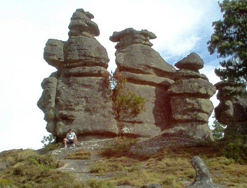
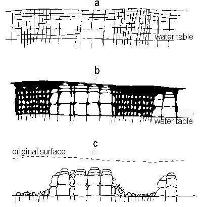
Only six of the 25 have death rates above the national average. Mazatlán has the highest drug war death rate, about four times the rate for all of Mexico, but still less than a fourth that of Ciudad Juárez. The rate for Playas de Rosarito is also very high, even higher than that of its northern neighbor Tijuana. Interestingly, its southern neighbor Ensenada has a low rate, about one eighth that Playas de Rosarito.
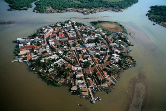
The drug war death rate for Tepic, Nayarit is over twice the national average. The rates are also relatively high for Cuernavaca and Nuevo Laredo. Actually, the rate for Nuevo Laredo is less than most of the smaller municipalities surrounding it. There is considerable variation among three adjoining municipalities near Lake Chapala: Ixtlahuacan (43.8), Jocotepec (28.5) and Chapala (18.4). All three have rates many times higher than the nearby city of Guadalajara (9.7).
I wonder how much these drug war death rates are affecting or will affect the choices that foreigners make concerning where to live or where to vacation in Mexico?

Previous posts in this mini-series:

Related posts about the geography of drug trafficking and drug cartels in Mexico:

Geo-Mexico: the geography and dynamics of modern Mexico discusses drug trafficking in several chapters. A text box on page 148 looks at trends in the drug trafficking business and efforts to control it. Buy your copy today to have a handy reference guide to all major aspects of Mexico’s geography!

Dec 182010
 

One of Mexico’s best kept travel secrets for people driving their own vehicle is the multitude of road signs all beginning with the word “microondas” (literally “microwaves”). Even visitors with good Spanish and a bilingual dictionary in their glove compartment may puzzle over the meaning of this frequently occurring sign, which invariably seems to lead onto a cobblestone track going, so far as one can tell, absolutely nowhere! There is no distant church tower, no sign of habitation, just a radio mast on the distant skyline. And that (rather than microwave ovens) is precisely what the sign refers to: a short-wave communications post!

One of the numerous benefits for the geographer is that virtually any microondas station offers a short, usually interesting side-trip, ideal for a brief respite from the demands of high speed highway driving. The well maintained, cobblestone tracks that provide access to the communications towers serve not only engineers, but also enterprising tourists. The access roads may follow devious routes but they eventually reach the gates of a fenced enclosure, invariably situated on the highest point for several miles in any direction. While there is no guarantee of an uninterrupted view, most microondas stations afford tremendous vistas over the surrounding countryside.

Microondas at top of Cerro de los Caballos. Photo: Gabriel Chaparro Tre….

View from the Microondas atop Cerro de los Caballos. Photo: Gabriel Chaparro Tre….

Very few vehicles use these excellent side roads, so they are usually safe and convenient places to stop, take a rest, stretch your legs and enjoy a picnic. As the tracks wind upwards, they often traverse successive vegetation zones, going from oak woodland up into pine forest if the mountain is high enough, for instance. This provides botanists and birders a range of habitats and transition zones worth exploring. Of course, some microondas sit on top of small mounds surrounded by a seemingly limitless flat and monotonous plain, home only to an infinite number of cacti. But others, the jewels of their kind, are in the midst of tropical rainforest looking out over canyons where spider monkeys can be seen leaping from branch to branch.

In the volcanic central areas of Mexico, microondas stations are commonly perched on crater rims, making many volcanoes fall in the “drive-in” category, including the Volcán Nevado de Toluca (Xinantécatl).  Full descriptions of the scenic wonders to be encountered on drives up, for example, Ceboruco volcano or Tequila volcano (the former in Nayarit state, the latter in Jalisco) merit a book unto themselves. To anyone who has never seen the legacies of past vulcanicity at close quarters, what more awesome and eye-opening introduction could there possibly be?

Needless to say, though you’re never far from the highway, you mustn’t expect to find any tourist amenities at microondas, not even “microwaved” fast-food. But don’t let that put you off visiting Mexican-style microwaves.

So, next time you spy “microondas” on a road sign (or, if you’re reading this in the depths of northern winter, the next time you press a button on your microwave!), remember – a short detour along one of Mexico’s best-kept travel secrets might well lead you to discover your own favorite stopping place. Someday, somewhere, someone should produce a comprehensive guide to the microondas of Mexico…

Mexico’s volcanic landscapes are discussed in chapters 2 and 3 of Geo-Mexico: the geography and dynamics of modern Mexico. Buy a copy as a seasonal gift today!