Drug war impacts extend to child arrests, border tunnels and stressed zoos

 Mexico's geography in the Press  Comments Off on Drug war impacts extend to child arrests, border tunnels and stressed zoos
Feb 252012
 

More children being arrested

One extremely unwelcome development in the war on drugs is that an increasing number of young adolescents (aged 11 to 17) are involved in drug smuggling and related activities, according to U.S. Drug Enforcement Administration and U.S. Immigration and Customs Enforcement (ICE). Most of the children are Hispanic, and many hold US citizenship. They are enticed by the lure of “easy” money and know they that, if caught, they can be tried only as juveniles. The Gulf cartel and the Zetas reportedly pay adolescents an average of $500 to smuggle drugs, and $1,000 to guard a kidnap victim for a month. In southern California, the number of arrests of adolescents has risen sharply, with charges ranging from drug trafficking to extortion and kidnapping.

Where are most drug tunnels?

Several major cross-border drug tunnels have been unearthed in the past few months, including one linking warehouses in Tijuana and San Diego which contained 32 tons of marijuana. This tunnel, 600 meters long, was particularly sophisticated and used electric rail cars. More than 70 cross-border tunnels have been found since October 2008.

Significant clusters of tunnels have been found in three main areas:

  • San Diego,
  • California’s Imperial Valley, where the clay soil makes for easy excavation
  • Nogales (Arizona), a city underlain by a network of existing underground drainage canals

Mexico’s zoos struggle to cope with unexpected influx of exotic animals

Press reports such as Captured Drug Kingpin’s Pets Strain Mexican Zoos have highlighted the problems resulting when rare and dangerous animals are confiscated from drugs cartel leaders. Several major cartel figures have amassed extensive private collections of exotic animals, from ostriches and parrots to monkeys, tigers, lions and giraffes. For example, when Jesús “The King” Zambada, a powerful member of the Sinaloa drug cartel, was arrested in mid-2011, authorities had to find new homes for several hundred animals, many of them exotic species. The nation’s zoos are struggling to cope with the influx of so many unexpected new arrivals.

Drug capos do not view animals only as a status symbol. They are also a means to hide drug shipments. Animals have also regularly been used in drugs trafficking. In recent years, grisly finds have included frozen sharks stuffed with cocaine, cocaine-fed snakes, and even liquid cocaine in shipping containers used for tropical fish.

Related posts:


Feb 132012
 

No one doubts the need for reforestation in Mexico. Since colonial times, huge swatches of the country have been denuded of their native vegetation. Recent figures from INEGI suggest that Mexico has lost almost 50% of its native forests due to logging and clearance for farming and settlement. The majority of this loss is in the Volcanic Axis belt that stretches west-east across the center of Mexico at an average height of 3000 m above sea level, but tropical rainforest areas much further south have also been decimated.

There is, however, some encouraging news.

Data released by the UN Environment Programme (UNEP) puts Mexico in a lofty 4th place worldwide for the number of trees planted since UNEP began its “Billion Trees Campaign”  in 2007. According to the UNEP figures, only China, India and Ethiopia have planted more trees than Mexico.

The “Billion Trees Campaign, inspired by the work of the late Nobel Peace Prize Laureate Wangari Maathai, recognizes that trees bring multiple benefits to people, ranging from carbon sequestration and the provision of timber to soil erosion control, enhanced aesthetic value and opportunities for recreation. UNEP claims that 12 billion trees have been planted worldwide since the program began.

The short Youtube video – Taking Root The Vision of Wangari Maathai –”tells the dramatic story of Kenyan Nobel Peace Prize Laureate Wangari Maathai whose simple act of planting trees grew into a nationwide movement to safeguard the environment, protect human rights, and defend democracy—a movement for which this charismatic woman became an iconic inspiration.” (http://takingrootfilm.com)

Poster prepared by Reforestamos México A.C.

Poster prepared by Reforestamos México A.C. (Mexican NGO) Visit www.reforestamosmexico.org for more information

But are the UNEP figures all they appear to be? Certainly, Mexico’s Environment Secretariat has organized, for many years, on-going programs of reforestation and conservation designed to stem the tide of logging that decimated Mexico’s natural forests over the past century. Official figures show that the pace of this effort has accelerated in the past few years. For example, between 2007 and 2011, Mexico’s National Forestry Commission protected, restored or reforested 21,000 square kilometers  (8100 sq. mi) across the country, an area equivalent to the state of Hidalgo. The total area reforested in those five years amounts to more than 3500 square kilometers  (1350 sq. mi).

On the other hand, critics of Mexico’s forestry policies, such as Greenpeace claim that up to 70% of all lumber sold in Mexico has been illegally harvested, and that less than 60% of trees planted in national campaigns survive their first few critical years.

Deforestation in the Monarch Butterfly Biosphere Reserve

One of the most critical areas, one where continued deforestation could be a real “game-changer”, is the Monarch Butterfly Biosphere Reserve which straddles the boundary between Michoacán and the state of Mexico. This is where millions of Monarch butterflies arrive each year from as far north as Canada to spend their winter. The butterfly itself is not endangered (there are non-migratory populations in many countries, and a year-round resident population in Mexico) but what assuredly is endangered is the “migratory phenomenon” of the Monarchs. Adequate forest cover at an altitude where winter weather is consistently within a narrow temperature band is absolutely crucial to the survival of this spectacular annual migration.

According to the National University (UNAM)’s Environmental Geography Research Center, at current rates of deforestation, the area of overwintering sites for the Monarch butterflies could be reduced by 75% in the next 18 years, leaving just 12,000 ha of suitable habitat. The protected area, established in 2000, covers 560 square kilometers (56,000 ha. or 216 sq. mi) but includes land cleared for pasture, settlement and cultivation. Researcher José López García claims the reserve is losing 3% of its forest each year. He blames clearance and changes of land use more than illegal logging. The rate of forest clearance has been exacerbated by a rapid rise in the population of the El Rosario ejido. El Rosario is the gateway to the most-visited part of the reserve, attracting thousands of tourists annually. The ejido’s population rose by an average of 5.65%/year between 2005 and 2010.

How will climate change affect Mexico’s forests?

Climate change is predicted to have several effects on Mexico’s forests. These include:

  • tropical rainforests (in both Mexico and Brazil) will gradually decline in extent, rainforest soils will have reduced fertility and some parts will become tropical grasslands.
  • the semi-arid areas in central and northern Mexico will become drier, and the total area of arid areas will increase

Globally, deforestation is believed to account for 17.4% of greenhouse gas emissions, so forest protection and reforestation are key strategies in efforts to mitigate the effects of further cliamte change.

Eco-tortillas: an environmentally friendly way to make Mexico’s staple food

 Mexico's geography in the Press  Comments Off on Eco-tortillas: an environmentally friendly way to make Mexico’s staple food
Feb 092012
 

Mexican scientists continue to find ways to improve the humble tortilla, one of the essential components of Mexican cuisine and a major source of calcium for many Mexicans. We described two years ago how researchers at the Autonomous Metropolitan University of Mexico (UAM) had reduced pollution from the making of corn tortillas. This month, a press release from Cinvestav (Centro de Investigación y de Estudios Avanzados del Instituto Politécnico Nacional) reveals that researchers have developed a way to reduce the amount of lime required in the making of tortillas, while enhancing their dietary value. This will further reduce the pollution and ecological footprint associated with tortilla making:

Researchers have developed “environmentally friendly tortillas” that are more nutritious, help prevent osteoporosis, slow the aging process and help fight obesity. A team led by Juan de Dios Figueroa Cárdenas, of Cinvestav’s unit in Queretaro, developed an environmentally-friendly method to turn gourmet corn into tortillas that have a high nutritional content and double the shelf life, without increasing the price of the final product.

The current process used to make tortillas is “highly polluting” and “not very efficient,” resulting in tortillas that “in many cases do not contain the fiber or calcium” people need. Given the importance of tortillas in the Mexican diet since pre-Columbian times, researchers worked on developing a process that “does not produce pollutants” and replaces lime, a corrosive substance, with salts and other ingredients in the cooking process. The use of other salts retains the outer layers of corn kernels during cooking and preserves a large amount of nutrients that end up being lost in the existing process and generating an enormous amount of pollution and wasted water.

The tortillas are also useful in fighting obesity (a huge problem in Mexico) because they contain double the fiber of a traditional tortilla, Figueroa Cárdenas said, adding that the tortillas’ high calcium content will help prevent osteoporosis.

[This post is based on the text of the press release]

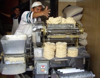
Tortilla-making. Photo: krebsmaus07 (Flickr)

Related posts:

Nestlé helps program to regenerate Mexico’s coffee industry

 Mexico's geography in the Press  Comments Off on Nestlé helps program to regenerate Mexico’s coffee industry
Jan 282012
 

Coffee trees are planted on 688,000 ha in 12 states, mainly in southern Mexico. The main coffee-producing states are Chiapas, Oaxaca, Puebla, Veracruz and Guerrero. As we reported in an earlier post, Mexico is financing a program to gradually replace aging coffee trees. The average yields of coffee in the 2010-11 season did show a slight increase on previous years. Officials hope this is the start of a trend of higher yields as the older trees are gradually replaced. The program to replace coffee trees is being supported by Nestlé, the Swiss food corporation.

Between 2002 and 2010, more than 4,000 growers in several states benefited from Nestlé’s distribution of more than 3.9 million coffee plants as part of a nationwide plan to replace aging coffee trees. Nestlé has since announced that it plans to establish its first coffee-propagation center in Mexico, in the southern state of Chiapas, in a joint venture with Agromod, a Mexican crop technology company, and the National Forestry, Farming and Fishing Institute (Instituto Nacional de Investigaciones Forestales, Agrícolas y Pecuarias, INIFAP).

The project will supply 30 million coffee plants by 2020, and mean that Nestlé will no longer need to import coffee plants to Mexico from its facility in Tours, France. As many as 20,000 coffee-growers will benefit from the project. Most of the new plants will be arabica varieties (for premium beans); the remainder will be robusta varieties (used in instant coffee blends).

Related posts:

How sustainable is organic agriculture on the Baja California Peninsula in Mexico?

 Mexico's geography in the Press, Updates to Geo-Mexico  Comments Off on How sustainable is organic agriculture on the Baja California Peninsula in Mexico?
Jan 192012
 

In recent years, a farming boom has completely changed the landscape in parts of Mexico’s Baja California Peninsula. The new landscape is comprised of organic farms, specializing in growing fresh produce, especially out-of-season, certified organic, fruits and vegetables, which carry premium prices.

“Organic” has come to mean very different things in different countries, but the essential common element is that it uses no synthetic fertilizers, hormones or pesticides. In the USA, the term “organic produce” also requires that farmers protect water resources, though this is hard to define and at least as hard to enforce.

The Baja California Peninsula receives very little rainfall, so irrigation water for its organic farms comes from underground aquifers. The profitability of these new farms relies on the availability of irrigation water and on the proximity of the region to the lucrative US market for organic produce.

The new farms may be “organic”, but the bigger question, examined by Elisabeth Rosenthal in Organic Agriculture May Be Outgrowing Its Ideals, in the New York Times is, “Are these organic farms sustainable?” Rosenthal looks in some detail at whether or not organic farms protect the local environment and the livelihood of local farmers. The article discusses the extreme stress being placed on the area’s ground water reserves. Some farmers are already in trouble because their wells have dried up. More than one-third of aquifers in the southern part of the peninsula are officially classified as “over-exploited”.

Growers blame the area’s tourism industry for the water shortages, arguing that hotels and golf courses gobble up far more than their fair share of the precious resource. Despite the aridity of the southern section of Baja California Peninsula, the southern coast, centered on Los Cabos, has far more golf courses per unit area than anywhere else in the country.

The “organic” label also takes no account of the emissions involved in production and transport of fruits and vegetables to the marketplace; export-oriented horticulture in the Baja Peninsula is an energy-intensive enterprise. Adding to the unsustainable side of the argument, some of the organic farms practice “monoculture”, growing a single crop year after year on the same land, a system known to lead to soil depletion and increase the risk of pest-related problems.

On the other hand, the new farms also provide an alternative source of jobs to tourism. Del Cabo, which has a cooperative packing plant in San José del Cabo and trucks or flies more than 7 metric tons of produce to the USA every day, is able to help its members by supplying high-quality seed, and employing specialists in plant raising and plant diseases who act as consultants to individual farmers as required. Del Cabo criticized the New York Times story for its numerous inaccuracies regarding water usage and sustainability.

Conscious of the water issues, many of these modern organic farms employ sophisticated, water-conserving irrigation systems, such as computerized drip irrigation. They also grow many crops under shade. Such systems are expensive to install and maintain, so most of the bigger producers are US-owned companies.

In Organic Tomatoes in January: Sucking Mexico Dry, in Mother Jones, Tom Philpott compares the situation in Baja California with that in “another region famous for winter tomatoes and dirt-cheap labor costs: Immokalee, Florida, source of a huge percentage of non-organic winter tomatoes consumed in the United States.” Philpott concludes that “What’s going on in Baja seems more about generating a premium-priced product while systematically degrading a landscape. Want organic tomatoes in the cold months? Buy them in a can.”

Food for thought!

Related posts:


The urgent need for reforestation of hills near Mexico City

 Mexico's geography in the Press  Comments Off on The urgent need for reforestation of hills near Mexico City
Jan 172012
 

A coniferous tree plantation is being formed on the lower slopes of Ajusco, the 3,930 m (12,894 ft) volcanic peak that overlooks the southern part of Mexico City. After decades of uncontrolled land clearance, local farmers are replanting 800,000 trees as part of a sustainable project which will ensure them a reliable income for years to come. Mexico’s National Forest Commission estimates that mature coniferous plantations are highly profitable, and should repay farmers a 500% return on their investment. Individual trees have to be at least 8 years old before they can be harvested.

Three species of conifers are being planted: the Sacred Fir (oyamel), Douglas Fir and Mexican White Pine (ayacahuite). At present, only about one-third of Christmas trees sold in Mexico are natural trees, with 60% of these having to be imported from as far away as Canada.

The project will not only increase farmers’ incomes, it will also reduce soil erosion, increase carbon storage, and bring hydrological benefits. Mexico City has seriously depleted its aquifers – see Why are some parts of Mexico City sinking into the old lakebed? Reforesting the hills surrounding the city means more water will be retained in the soil, and less will runoff into the city’s already-stressed network of storm drains.

Ajusco is not the only volcanic peak near Mexico City where deforestation has become a major issue. In August 2011, National Water Commission (Conagua) officials blamed serious flooding in the Rayón municipality of the State of México on the uncontrolled logging of the lower slopes of the Nevada de Toluca volcano.

The lack of protective forest cover meant that heavy rain caused the River Santiaguito to burst its banks and flood homes in the community of San Juan La Isla. The situation would have been far worse if Conagua had not ordered the dredging of 12,000 cubic meters along a 4 km stretch of the river bed in 2009. Following the 2011 floods, Conagua reiterated the need for more reforestation and called for stricter land use controls to prevent similar problems in the future.


Jan 122012
 

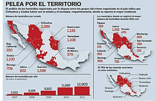
The Mexican Attorney General’s Office has released data for narco-related homicides for the first nine months of 2011. The data show that 12,903 narco-related deaths occurred in that period. The 2011 figure is 11% higher than the number of narco-related deaths reported for the same nine months in 2010. Even in the absence of data for the last quarter of 2011, we can safely assume that the total number of drug-related deaths in Mexico since the start of the “drug war” in December 2006 now exceeds 50,000.

As we have stressed in previous posts about drug-related violence in Mexico, the data for January-September 2011 show that violence is heavily concentrated in certain parts of the country, with other regions (such as Baja California Sur, Oaxaca and the Yucatán Peninsula including Quintana Roo) remaining untouched.

Narco-violence, January-September 2011

Narco-violence, January-September 2011 (El Universal)

As this graphic (original here) from Mexico daily El Universal shows, eight states (out of 32) accounted for 70% of all the homicides in the first nine months of 2011: Chihuahua, Guerrero, Nuevo León, Tamaulipas, Durango, Jalisco, State of México, Coahuila.

The ten municipalities with the highest number of homicides were Ciudad Juárez, Acapulco, Torreón, Monterrey, Culiacán, San Fernando, Durango, Mazatlán, Tijuana and Veracruz.
[* see comment below]

In all cases, it should be remembered that the data are for the total number of homicides and are not homicide rates (i.e. data adjusted for population size).

Mexico’s Puente Baluarte, the world’s tallest cable-stayed bridge, now officially open

 Mexico's geography in the Press, Updates to Geo-Mexico  Comments Off on Mexico’s Puente Baluarte, the world’s tallest cable-stayed bridge, now officially open
Jan 052012
 

Earlier today, President Felipe Calderón inaugurated the Puente Balarde, the world’s tallest cable-stayed bridge.

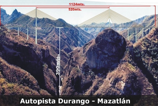
The bridge is 1.124 km long and wide enough for 4 lanes of traffic. Its central span extends 520 meters. At its highest point, it is a gravity-defying 403 metres (1322 feet) above the River Baluarte from which it takes its name. The bridge’s largest supporting pillar is 153 meters high, with a base measuring 18 meters by 30 meters.

Puente Baluarte Bicentenario. Photo: TRADECO

Construction, by Mexican firm TRADECO, has required 103,000 tons of cement and almost 17,000 tons of steel. The bridge joins the states of Durango and Sinaloa and removes the need for drivers to negotiate a very dangerous stretch of highway known as the Devil’s Backbone.

It is the centerpiece of a new highway between Durango and the Pacific coast resort of Mazatlán. The 312 km drive between the two cities, which took about five hours prior to the completion of the bridge, will now be dramatically shortened.

“This project will unite the people of northern Mexico as never before,” President Calderón said at the inauguration ceremony. Accordoing to the BBC, officials from the Guinness World of Records were on hand to present him with an award recognising the engineering feat. The previous record holder was the elegant Millau Viaduct in France.

Travel Note:

Even though the bridge has been inaugurated, the new Durango-Mazatlán highway is still many months from completion.

Update: New Durango-Mazatlán highway officially open(Oct 2013)

Related posts:


The geography of the 2011 Pan American Games (Juegos Panamericanos)

 Mexico's geography in the Press  Comments Off on The geography of the 2011 Pan American Games (Juegos Panamericanos)
Jan 022012
 

The XVI Pan American Games were held from October 14–30, 2011 in Guadalajara (Jalisco) with some events held in outlying locations such as Ciudad Guzmán, Puerto Vallarta, Lagos de Moreno and Tapalpa. They were the largest multi-sport event of 2011. Some 6,000 athletes from 42 nations participated in 36 sports. The largest contingents of athletes (more than 500 in each case) came from host nation Mexico, Brazil, Argentina, the USA, Cuba and Canada.

Guadalajara is Mexico’s second city, a metropolitan area of almost five million people, the industrial and commercial hub of a region that is considered quintessentially Mexican, home to charrería (Mexican horsemanship), jarabe tapatío (Mexican hat dance), mariachi music, and tequila, the national drink.

This post looks at the impacts of the Pan American Games on the local economy.

How much investment was required to host the games?

The original budget for the Games was $250 million (dollars), but this ballooned to about one billion by the time of the Opening Ceremony. The security budget was $10 million, to pay 10,000 municipal, state and federal police, as well as elements from the Mexican army and navy, to patrol the streets surrounding the venues during the games.

How many visitors attended the Games?

The State Tourism Secretariat expected 800,000 visitors and spending of $75 million (dollars). Some government spokespersons claimed that between 1 and 1.5 million attended the games. However, a study released by the Guadalajara Chamber of Commerce found that 454,148 visitors came to Guadalajara during the games (305,177 from the state of Jalisco, and 148,971 from elsewhere). 83% (424,354) of visitors came “specifically for the Games”.

How many jobs were created?

The build-up to the games created some 50,000 new jobs. In addition, more than 6,000 volunteers, mainly students, were employed during the games.

How much were the media and TV rights worth?

1,300 media representatives attended the games. More than 750 television hours of sports were broadcast, with global digital media company Terra broadcasting the games live in 13 simultaneous high-definition online channels. The TV rights were worth $50 million.

How many sports venues were used?

There were 32 different venues used during the games. Billions of pesos were spent building 19 impressive new sports stadiums and complexes. Thirteen existing sports arenas in the Guadalajara metro area were rebuilt or extensively refurbished. The opening and closing ceremonies for the Pan American Games were held in a 48,000-seat local soccer stadium, the Omnilife Stadium (Estadio Omnilife), built in 2010 for the Guadalajara “Chivas” soccer team.

Facilities built specifically for the games included an iconic Aquatics Center (Centro Acuático), sponsored by Scotiabank, with two Olympic-size pools and seating up to 3,500 spectators, and a state-of-the-art gymnastics venue, sponsored by Nissan.
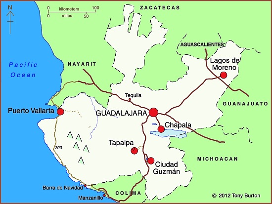
2011 Pan American games venues in Jalisco, Mexico

2011 Pan American games venues in Jalisco, Mexico

How did the games help regional development?

Several sports events were held at sites well away from the Guadalajara metro area. This helped promote a regional profile for the games. The five locations involved (see map) were:

  • Puerto Vallarta (beach volleyball, open water swimming, triathlon, sailing)
  • Lagos de Moreno (baseball)
  • Ciudad Guzmán (rowing, canoeing)
  • Chapala (water skiing)
  • Tapalpa (mountain biking)

How much did visitors to the games spend?

Local businesses reported sales up 7% during the period of the Games. The total games-related spending by visitors was estimated at $210 million (dollars). Hotel occupancy rates for the period of the games rose from 58.3% in 2010 to 76.4% during the games. The rate was 97% for the 5-star hotels in Guadalajara and Puerto Vallarta.

Even so, according to a local newspaper (The Guadalajara Reporter), local business owners were “underwhelmed” by the Pan American Games’ impact. Restaurants, bars, clubs, taxis and travel agencies all received fewer customers than anticipated. Local business owners said that “very few foreign tourists came for the games, while most spectators at the events were local citizens, athletes and their families, journalists and other games-affiliated personnel.” Business owners in Puerto Vallarta were reported to be “angry at the lack of publicity for the destination”.

Problems with the Athletes Village

The Pan American Athletes Village (Villa Panamericana) was built one kilometer outside Guadalajara’s western ring-road (Periférico) to house all 6,000 participants. The location is conveniently close to the Omnilife Stadium, site of the opening and closing ceremonies.

The Athletes Village has three-bedroom apartments, a central plaza, restaurant, gym, discotheque, chapel, swimming pool, theater and health clinic. The original plan was for the Village apartments to be sold after the Games for between $90,000 and $250,000 (dollars) each. However, the fate of the Athletes Village is still uncertain, because residents of the nearby (and long-established) Rancho Contento subdivision have taken the owners to court,  demanding that the Athletes Village be demolished since it has already caused irreparable damage to the local ecosystem.

Apart from some issues of housing density in this area, the main concern is that the village has inadequate provision for sewage. After the Games ended, local newspapers reported that faulty treatment plants had resulted in sewage being pumped out of the village on to land inside the nearby Primavera Forest biosphere reserve. Apparently, two of the Village’s treatment plants “collapsed” under the volume of wastewater generated, and partially-treated sewage had collected as open ponds. It is unclear if the sewage contaminated local subsoil and streams. After the Games, city officials closed the plants and fined the Athletes Village administrators. The administrators claim that the plants and Village had been designed to accommodate only 2500 to 3000 athletes, not the 6000 participants that were later housed there.

Conclusion

The lasting legacy of the games is a number of new hotels in Guadalajara, including hotels in the Westin and Riu chains, and a number of new or upgraded sports venues. In addition, many roads were repaved and numerous other beautification projects have helped improve Guadalajara’s urban fabric and infrastructure. The city’s main exhibition space (Expo Guadalajara) and the international airport have both been expanded.

The first obvious benefit of these improvements has been that the city (and its new Aquatics Center) have been chosen to host the 2017 World Swimming Championships.

Related posts:
Dec 172011
 

Mexico’s Magic Town (Pueblo Mágico) designation is given to inland destinations that offer a complementary tourism based on historic and cultural attributes. Mexico’s federal Tourism Secretariat has announced there will be 52 Magic Towns by 2012, when the promotional program is due to end. Mexico currently has 48 Magic Towns. Since our list earlier this year (see Mexico adds three more Magic Towns to its list) four more towns have been added to the select club. All are well worth visiting!

Magic Town #45: El Oro de Hidalgo (State of México)

The small town of El Oro (population about 6,000) is in the western part of the State of México, close to the state limit with Michoacán. It is a former mining town which was largely abandoned when its mineral reserves (gold) ran out. It has several very attractive old buildings and a state Mining Museum.

Magic Town #46: Xico (Veracruz)

Xico is located in the central part of Veracruz state, about 25 km from the state capital Xalapa, in an agricultural area known for tropical fruits and coffee. In the vicinity are the Texolo waterfalls, where the movie “Romancing the Stone” was filmed. Xico holds a lively annual fair every July, complete with colorful sawdust carpets and bull-running.

Magic Town #47: San Sebastián del Oeste (Jalisco)

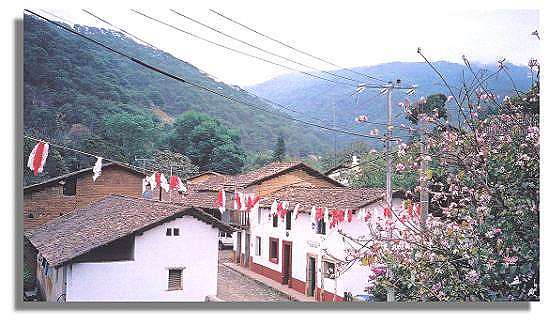
San Sebastián del Oeste is another enchanting old mining town, founded in 1605, located in the rugged mountains which separate the interior valleys of central Jalisco from the Pacific Coast, at an altitude of 1500 meters (5,000 feet) above sea level. Local mines yielded a fortune in gold, silver and copper, before the town lapsed into quiet lassitude once the ore reserves were exhausted. It is amazing to think that all the salt used in the silver processing had to be brought on horseback over the mountains from a tiny primitive port called Puerto de las Peñas, at the mouth of the River Cuale, a port now known as… Puerto Vallarta!

San Sebastián del Oeste

San Sebastián del Oeste

Magic Town #48: Xilitla (San Luis Potosí)

The town of Xilitla is set in luxuriant rainforested mountains in San Luis Potosí. It is best known as the site of Las Pozas, Edward James’ surrealist jungle fantasy. To read more about Xilita, try the following articles on MexConnect:

Related posts:

Value-added from solid waste in Mexico

 Mexico's geography in the Press  Comments Off on Value-added from solid waste in Mexico
Dec 142011
 

In a previous post, we looked briefly at the role of plastics recycling in Mexico City’s waste separation program. In this post, we describe two other developments related to solid waste disposal.

Recycling finally reaches the take-off point in Mexico

Nationwide, it took an entire decade for the plastics recycling rate in Mexico to increase from 10 to 15%. Then, in 2010, as more companies sought part of a potentially very lucrative market, the rate shot up to 17%. Admittedly, though, Mexico still lags far behind the 22% rate boasted by the European Union members in this regard.

Mexican industry generates 3.8 million metric tons of plastic waste a year (36% of it in Mexico City). The nationwide recycling capacity for plastics (geared towards hard plastic or PET) currently stands at only 646,000 metric tons, so there is plenty of room for more companies and recycling plants.

Garbage-powered street lights

The World Bank is helping finance a new bio-energy project in Monterrery which will reduce emissions by the equivalent of a million tons of CO2. This is about the same quantity as the annual emissions of 90,000 vehicles, or the amount of CO2 that would be absorbed annually by a forest with an area of 970 hectares.

The project, run by Bioenergía de Nuevo León, uses methane gas given off by decomposing garbage in one of the city’s landfills, in Salinas Victoria, which receives 5000 tons of garbage a day. The power plant’s installed generation capacity of 17mW should be sufficient to supply 90% of the nighttime street lighting in the Monterrey metro area. During the day, power from the project is supplied to the city’s metro system. Any surplus is sold to the Federal Electricity Commission and fed into the national grid.

photo of garbage

Recycling has a long way to go...

Related posts:


Dramatic fall in grain production means higher imports

 Mexico's geography in the Press  Comments Off on Dramatic fall in grain production means higher imports
Dec 082011
 

Mexico’s production of basic grains has fallen 8.5% this year (compared to 2010) to 28.5 million metric tons, according to FAO (Food and Agriculture Organization) estimates. This is a very serious fall, exceeded (on a percentage basis) only by South Africa (15.8%) and Ethiopia (11.3%).

As a result of the fall in production (largely due to the drought affecting much of the northern part of the country), Mexico is expected to import about 11 million tons of grain, mainly corn, almost a million tons more than last year.

Mexico was the world’s 6th largest grain producer in 2010, but has fallen to 8th spot in 2011, overtaken by Russia and Argentina. The world’s five largest grain producers are USA, China, European Union, Brazil and India. Countries lagging behind Mexico for production of basic grains include Canada, Australia, Indonesia and Nigeria.

Dec 072011
 

The federal government has announced a six-year overhaul of Mexico’s domestic natural gas market, coupled with building some major extensions to the existing natural gas pipeline network.

Recent discoveries of massive reserves of shale gas have prompted the government to abandon plans to build more nuclear power stations and focus more attention on natural gas. New combined-cycle power stations are planned, alongside 4,400 km of new pipelines, which will be funded by 8 billion dollars of public-private financing and bring natural gas to more than 5 million potential consumers for the first time.

The expansion of Mexico’s pipeline network will extend the system into four states–Zacatecas, Colima, Sinaloa and Morelos–where natural gas was previously unavailable. The improvements in infrastructure should persuade many businesses to switch from oil and liquid petroleum gas to cleaner and less expensive natural gas.

Projected gas pipeline network, 2020.

Mexico's projected natural gas pipeline network, 2020.

The major projects are shown on the map (green pipelines already exist). The Manzanillo-Guadalajara section (shown in red) is already built and being subjected to final testing before being brought on-stream early in 2012. It will immediately increase the competitiveness of companies in several key parts of central Mexico.

Related posts:


Mexico’s 2011 drought is raising the price of basic foodstuffs

 Mexico's geography in the Press  Comments Off on Mexico’s 2011 drought is raising the price of basic foodstuffs
Dec 052011
 

This year’s drought – see Many states in Mexico badly affected by drought is now widely viewed as the worst to occur since modern record-keeping for precipitation began about 80 years ago.

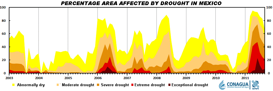
Short-term droughts are not unusual in Mexico. As the graph shows, there is a clear cyclical pattern to the timing of short-term droughts in Mexico. This is because most of the country receives almost all its annual precipitation in just a few months, from May or June (depending on precise location) to September-October.

The scale of the current drought is readily apparent from the graph. This year, far more of the country is affected, and the level of drought is far more severe.

Seasonal drought in Mexico, 2003-2012
Seasonal drought in Mexico, 2003-2012. Click to enlarge.

The drought is having numerous adverse impacts

It is already having an effect on food prices. Several of the basic foodstuffs  making up Mexico’s basic basket of goods for economic indices such as the inflation index, have risen sharply in price in recent months. A shortage of corn has led to a 70% increase in imports of yellow corn from the USA.

Incredibly, Mexico, the home of corn, is now the world’s second largest importer. Corn, as we have noted in previous posts, is a vital ingredient in Mexican cuisine, and is particularly important in the southern half of the country, especially in the more rural and indigenous areas. The shortage of corn has led to a rise in the price of tortillas, a dietary staple in almost all of the country. Tortilla prices have risen up to 18%, many times Mexico’s overall inflation rate of about 3.5%.

The production of chiles, another staple of the Mexican diet, has also fallen due to the drought, by an estimated 40%. In Zacatecas, that state’s 2,500 chile-growers will have produced 120,000 tons of green chile and 62,150 tons of dried chile this year, even though they have only been able to harvest chiles twice this year, rather than the normal four times. The state is the leading source of dried chile in Mexico. The area cultivated for chiles in Zacatecas has also fallen this year, to 31,300 hectares. The decrease in production has had a direct impact on the number of harvesting jobs available, since each hectare of chile cultivation usually means 150 seasonal jobs. The production shortage for chiles will be offset by more imports from Peru and China.

At latest count, 770 municipalities are now suffering from drought, and at least 2.5 million people in 1500 communities are left with insufficient drinking water. In the state of Durango alone, more than one million people are currently experiencing extreme drought, and 149 communities are completely without drinking water.

The long-term outlook is not favorable for these areas since climate change is expected to increase both the frequency and severity of droughts over the next twenty to thirty years.

Related posts:

Unusual hazard: gasoline pours out of storm drains in Poza Rica, Veracruz

 Mexico's geography in the Press  Comments Off on Unusual hazard: gasoline pours out of storm drains in Poza Rica, Veracruz
Nov 262011
 

Recent floods in parts of the city of Poza Rica (Veracruz) resulted in an unusually dangerous situation. As groundwater rose following exceptionally heavy rains, a mixture of water and oil flowed out of some street drains.

street awash with oil photo

A Poza Rica street awash with oil and water. Credit: La Voz del Sureste

The precise cause is unknown. The city is blaming the state oil giant Petroleos Mexicanos (Pemex). Pemex claims that the hydrocarbons are natural tar, deposits of which underlie some parts of the region.

Whatever the cause, the flooding resulted in extremely hazardous conditions in the Chapultepec colonia, where Ébano, Nogal, Chopo, Eucalipto, Ciprés, Fresno and Sabino streets were badly affecfed, and in the Cazones colonia, where the aptly-named Pozo 13 (Well 13) was awash with oil. The mayor of Poza Rica was quoted as saying that “The rivers of crude left parked cars completely covered.”

Families living in the affected areas were evacuated temporarily for their own safety. Fortunately, local authorities, assisted by Environmental Protection officials and Pemex experts, were able to quickly bring the situation under control, without any loss of life or serious injuries.

Sources:

  • Brota hidrocarburo de drenajes en Poza Rica (Diario La Voz del Sureste online)
  • Concluyen limpieza de derrame de hidrocarburo en Poza Rica (xeu.com.mx)


Many states in Mexico badly affected by drought

 Mexico's geography in the Press, Updates to Geo-Mexico  Comments Off on Many states in Mexico badly affected by drought
Nov 232011
 

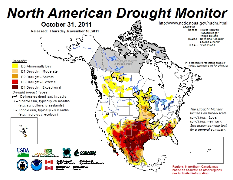
Much of Mexico is currently affected by some degree of drought (see map below). The National Meteorological Service (SMN) reports that September was one of the driest months in some 70 years. All the signs suggest this is the worst year for drought since 1941. The worst affected states are Sonora, Chihuahua, Coahuila, Durango, Nuevo León and Zacatecas. (Paradoxically, some parts of southern Mexico, especially in the states of Oaxaca and Tabasco, have experienced serious flooding in recent months).

In the drought zones, emergency programs are getting underway to provide temporary work for many rural dwellers and to supply potable water to the worst affected settlements. In addition to crop losses, up to one million head of cattle will have been put down by year-end in northern states as a direct result of the drought, since farmers do not have sufficient fodder available to feed them as usual.

While some cattle have been exported to the USA, local meat prices will be driven down by the increase in supply, making many farmer’s livelihoods even more precarious. Many farmers will need federal assistance to overcome this latest crisis.
Areas suffering from drought, October 2011

Areas suffering from short-term and long-term drought, October 2011. Click map to enlarge

Durango faces the worst drought for 100 years

In Durango, water has been provided to 32,691 residents in 10 municipalities, with another 36 municipalities to be supplied in the current phase of emergency assistance. Officials in Durango say it is the state’s worst drought for 100 years, with most larger reservoirs in the state now holding between 20% and 40% of their capacity; one reservoir is already down to less than 10% of its.

Irregular rains over the past few months have done little to replenish reservoirs, leaving farmers in despair. The long-range forecast does not appear to offer them much consolation, with the drought expected to last well into next year.

By mid-September, some parts of Durango had received less than 140 mm of precipitation so far ths year, well below the 425 mm registered for the same period in 2010.  The only hope for local farmers appears to be if late season hurricanes bring far more rain than expected to this region.

The drought news from other states

In Chihuahua, 589 tankers have delivered water to settlements housing 62,000 in 15 different municipalities: Guazapares, Janos, Manuel Benavides, Morelos, Moris, Ocampo, Ojinaga, Urique, Uruachi, Aldama, Balleza, Bocoyna, Guachochi, Guadalupe and Calvo.

In Zacatecas, a “state of emergency” has been declared for 52 of the state’s 58 municipalities. More than 150 communities are seriously affected, especially smaller communities in the municipalities of Fresnillo, Jerez, Guadalupe, Tlaltenango, Nochistlán, Atolinga, Villa de Cos, Genaro Codina and Teúl de Gonzalez Ortega.

Drought has affected 288,000 hectares of rain-fed crops in Guanajuato. The greatest losses are of corn, beans, wheat, sorghum and other grains, with the worst-hit areas located in the northern part of the state. More than a million liters of potable water have been supplied to 18,000 inhabitants living in 133 settlements in the state, located in the municipalities of Atarjea, Doctor Mora, San Diego de la Unión, San Felipe, Santa Catarina, Tierra Blanca, Victoria and Xichú.

Horticulturalists in Sinaloa growing vegetables, grains and fruit for export want 30 million dollars in emergency funds to restore irrigation to 700,000 hectares of productive land. More than 200,000 seasonal jobs are at risk.

Related post:

Mexico’s water resources and water-related issues are the subject of chapters 6 and 7 of Geo-Mexico: the geography and dynamics of modern Mexico. Ask your library to buy a copy of this handy reference guide to all aspects of Mexico’s geography today! Better yet, order your own copy…


Mexico reduces emissions with innovative carbon credit project

 Mexico's geography in the Press  Comments Off on Mexico reduces emissions with innovative carbon credit project
Nov 212011
 

Mexico is rapidly becoming a key market for environmental investments, and now accounts for one in every five projects involving Clean Development Mechanisms (CDMs) in Latin America. A recent Reuters news item gives the basic details of one CDP project:

  • Mexico to earn royalty on light bulb carbon credits

CDMs, established after the Kyoto Protocol, allow companies in developing countries to sell Certified Emission Reduction certificates (CERs) to buyers in industrialized countries, to offset their own emissions control targets. The certificates prove that there has been a reduction in greenhouse gas emissions.

One project involving CERs, started by Australian company Cool nrg International, will reduce Mexico City’s carbon dioxide (CO2) emissions by 16 million tonnes over the next 10 years. The company is distributing 30 million free energy-efficient lightbulbs to 6.5 million low-income households, which will save 33,000 gigawatt hours of electricity.

Watch Nick Francis from Cool nrg explain the plan and why it is a win-win-win for everyone concerned:

Every tonne of CO2 saved generates a CER credit (currently trading at 9 dollars). For every credit, Mexico receives a royalty payment. Cool nrg then sells the CERs to companies in industrialized countries. The project is a world first and its success will be closely monitored by many other countries.

Related posts:


Nov 162011
 

Mexico may have major reserves of petroleum but it lacks the necessary refining capacity to supply the domestic market with all the refined products such as vehicle fuels that its industrial, commercial and residential sectors demand.

As a result, Mexico has to import refined petroleum products, mainly from the USA. The high costs of these imports is a constant point of discussion in Mexico. If the country developed sufficient refining capacity, it could spend every dollar that currently goes on petro-based imports on something else, such as social services or infrastructure improvements.

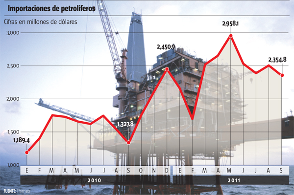
Pemex imports. Credit: milenio.com
Pemex imports, by month. Figures in millions of US dollars. Credit: milenio.com

A small fortune is being spent each month on petroleum-related imports (see graph). Over the past year, the cost of imports has risen 12.3%. This is almost entirely due to higher oil prices on international markets; the volume of imports has increased only 1% over the period.

Imports of refined petroleum products will not end any time soon. Mexico does plan to build new refineries and expand its refining capacity, but they will take years to complete. Earlier this year, it was reported that Pemex engineers were adding the final touches to the blueprints for a new refinery in Tula (Hidalgo). Work began with the re-routing of existing irrigation channels and high tension power lines to take them well away from the site. It remains unclear, though, just how long it will take for this project to be completed.

Related posts:


Nov 142011
 

A few months back, we wrote of the conflicts surrounding the proposed tourist mega-development near Cabo Pulmo. The controversial plans for Cabo Cortés involve building on the virgin sand dunes, and will undoubtedly have adverse impacts on the small village of Cabo Pulmo and the ecologically-sensitive Cabo Pulmo National Marine Park and its coral reef.

Later, we followed up with an in-depth look at how the establishment of a Cabo Pulmo Marine Park had led to an astonishing recovery of the area’s biodiversity:

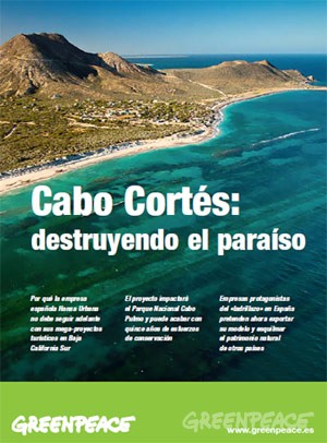
Cover of Greenpeace's position paper on Cabo Cortés

"Cabo Cortés: destroying paradise" (Greenpeace)

This story, which essentially pits mass tourism against ecotourism, continues to attract lots of media attention. The latest major article is Plans for resort in Mexico ignite concern about reef, published in The Washington Post. The article looks at the Spanish companies involved in the ownership and construction of the proposed resort and quotes the opinion of local people who hope that the economic crisis in Europe will put an end to their grandiose plans.

The Spanish firms involved are “ailing Spanish development conglomerate” Hansa Urbana, which bought the meg-development site in 2007, and a  savings bank called CAM (Caja de Ahorros del Mediterraneo), which lent Hansa millions of dollars.

Later, Hansa gave CAM the property in exchange for having its debt wiped clean. CAM has since been bailed out to the tune of $3.8 billion by the Bank of Spain, in which the Spanish government has a controlling interest. The Bank of Spain plans to auction CAM, but only after the upcoming Spanish elections.

As a result, and as the Washington Post article makes clear, “environmental activists are not even sure who controls the resort project anymore.”

Mexico’s federal Environment and Natural Resources Secretariat (Semarnat) originally gave Spanish firm Hansa Urbana the green light to begin construction, but now say that construction can only begin if the developers can prove that the reef will remain unharmed.

Mexican authorities are reported to be consulting with “expert marine biologists and U.N. officials”:

  • Misión conjunta de la UNESCO y Ramsar visitará Cabo Pulmo la próxima semana
  • La UNESCO visitará Cabo Pulmo

The government has set a deadline of January 2013 for the submission of a detailed report showing that construction will not cause any environmental damage to the Marine Park.

The deadline comes only a month after President  Calderon leaves office, which, as many locals realize, could be very unfortunate for the future welfare of the reef and local ecotourism activities.

The diffusion of violence in Mexico since the early 1980s

 Mexico's geography in the Press  Comments Off on The diffusion of violence in Mexico since the early 1980s
Nov 122011
 

Today, we take a quick look at Mexico, the Un-Failed State: A Geography Lesson, published on the InSight Crime website. InSight Crime’s stated objective is “to increase the level of research, analysis and investigation on organized crime in Latin America and the Caribbean.”

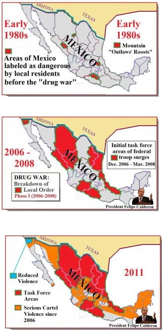
diffusion of violence in Mexico

Credit: InSightcrime.org

Gary Moore, the author of Mexico, the Un-Failed State: A Geography Lesson, considers some of the claims made recently about Mexico being a “failed state”, where parts of the country are effectively no longer under government control. As the title of article suggests, Moore does not find evidence to support these claims.

His position is set out early in the article when he writes that, “The statements are all serious assessments of an elusive reality. The violence in today’s Mexico forms a twilight zone. It is not an all-consuming apocalypse, but it is also not the relative peace of Mexico a generation ago.”

The article is illustrated by three maps, “snapshots” of the situation in the early 1980s, in 2006-2008 and in 2011. While these appear to show that there has been a significant expansion of violence across Mexico in recent years, some caution is needed since the evidence used for each map is entirely different.

Moore’s article is a useful overview of how and why violence has diffused across much of Mexico since President Felipe Calderón declared a “war on drugs” in December 2006. It is, though, only an overview. There are significant local differences even within those states (such as Tamaulipas and Chihuahua) which are considered to be among the worst for drug violence in the country.

Few analysts would disagree with the article’s concluding statements that:

“In the 1970s it was natural to assume that these throwback “bandido” areas were shrinking and would soon disappear, as the march of development brought education, opportunity and civilization.”

“The harsh news from the drug war is that the reverse has occurred. The landscape of no-go zones has swelled across Mexico, as at no time since the Mexican Revolution of 1910-1920.”

The Mexican Revolution threw Mexico into convulsions for more than a decade, and the war on drugs looks set to last at least as long.

Related posts:


Mexico adds three more Magic Towns to its list

 Mexico's geography in the Press  Comments Off on Mexico adds three more Magic Towns to its list
Oct 272011
 

Mexico’s Magic Town (Pueblo Mágico) program seeks to promote inland destinations that offer a complementary tourism based on historic and cultural attributes. The federal Tourism Secretariat has announced there will be 52 Magic Towns by 2012, when the promotional program is currently due to end. As many as 70 towns are reported to be seeking accreditation as Magic Towns. Some of these applicants are likely to join similar promotional groupings such as “Pueblos con Encanto” (Towns with Charm) and “Pueblos Señoriales” (Noble Towns).

Mexico currently has 44 Magic Towns:

The three latest towns to be added to the list are:

Magic Town #42: Mineral del Chico (Hidalgo)

Mineral del Chico is a small town (population 6700 in 2005; altitude 2351 m) at the entrance to the El Chico National Park in Hidalgo. The National Park, with its forests, mountains and waterfalls, is much better known than the town itself. This was the one of the earliest forested areas to be officially protected in Mexico. It was declared a Forest Reserve in 1898 and became a National Park in 1922.

Magic Town #43: Cadereyta (Querétaro)

The designation of Cadereyta as a Magic Town creates a great multi-day tourist trip including two other Magic Towns: Bernal and Jalpan de Serra. Cadereyta is known for its noisy and ebullient Holy Week (Semana Santa) processions, a tradition said to date back to the 18th century. The town has several interesting churches and two genuine colonial treasures. The gilded retable of the church of San Pedro and San Pablo has to be seen to be believed.

  • Tourism attractions of Cadereyta
  • Two colonial treasures of Cadereyta

Magic Town #44: Tula (Tamaulipas)

Close to the northern border, Tula, founded in 1617, is the oldest still-inhabited settlement in the state of Tamaulipas. The town has several colonial buildings but is best known for making elaborate leather jackets (cuera tamaulipeca), first designed in the 1950s.

These three latest newcomers all have their attractions, but, at least in my humble opinion, are not in the same league in terms of their historical and tourist interest as most previously-designated Magic Towns.

Related posts:

Gulf of Mexico energy reserves: updates in Mexico’s oil and gas sector

 Mexico's geography in the Press  Comments Off on Gulf of Mexico energy reserves: updates in Mexico’s oil and gas sector
Oct 252011
 

PEMEX awards first-ever contracts for the operation of oil fields.

In a move welcomed by international oil analysts, Pemex has awarded British company Petrofac Facilities Management Ltd. a contract to operate the Santuario oil fields in Tabasco. Prior to this contract, all oil field operations in Mexico since 1938 had been directly managed by Pemex.

Operations in two other areas – Magallanes and Carrizo – are also being contracted out. The areas cover 312 square kilometers between them, and have 3P (proven, probable, possible) reserves totaling 207 million barrels of crude oil equivalent. The contractual changes should attract considerable foreign investment in coming years, and are expected to play an important role in boosting national oil production from its current level of 2.5 million barrels a day.

Major natural gas discovery in the Gulf of Mexico

Pemex has announced that its Piklis 1 offshore well, located 150 km northwest of Coatzacoalcos in the Lakach field, has found a massive deposit of natural gas 5,431 meters below the water surface. The deposit holds more than 400 billion cubic feet of gas and, when production begins in 2014, it should yield 700-800 million cubic feet/day, reducing Mexico’s natural gas imports by up to 80% over the next 15 years. Compared to 2009, Pemex’s total revenues in 2010 rose 20.3% to 115 billion dollars, mainly due to high prices for petroleum and related products; export sales were 21.4% higher. Pemex is currently producing about 2.6 billion barrels of crude oil/day.

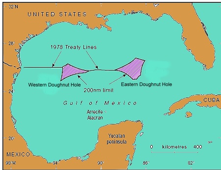
location of doughnut holes

How much does it cost to produce a barrel of oil?

According to Mexico City daily La Jornada, Pemex has maintained its enviable low costs per barrel of oil obtained (all figures in dollars):

  • 2006 $4.40
  • 2007 $4.90
  • 2008 $6.10
  • 2009 $4.90
  • 2010 $5.20

These costs per barrel are very competitive, and well below the costs recorded for other major firms as Total, BP, Exxon, Statoil, Chevron and Petrobras, who have production costs of between $6.10 and $10.00 a barrel.

Transborder oil fields

Several major oil and gas fields are known to straddle the international border in the Gulf of Mexico. Deepwater wells on the US side have already found massive deposits of oil, but, until recently, Pemex has not had the technology to drill in such deep waters. That is now changing. Pemex has begun drilling from the deepwater “Bicentenario” semi-submersible platform. The first well, Talipau-1, will descend 940 meters to the sea floor and then a further 5,000 meters into oil-bearing strata in the region known as the Cinturón Plegado de Perdido.

Pemex believes that deepwater wells in the Gulf of Mexico will eventually yield several billion barrels of oil.

The Bicentenario, built in South Korea, is capable of operating in water up to 3,000 meters deep; it is 100 meters in length, 78 meters wide and rises 138 meters above the surface, with a total weight of 58,000 metric tons. It will house up to 160 workers at a time.

In related news, bilateral talks were held in Washington DC at the end of August relating to offshore oil fields that straddle the Mexico-USA maritime boundary in the Gulf of Mexico. The talks will set the parameters for efficient and safe exploitation of these hydrocarbon reserves in the future. A formal agreement is expected to be completed before the end of this year.

Related posts:

Mexico receives $280m in international funding to fight urban poverty

 Mexico's geography in the Press  Comments Off on Mexico receives $280m in international funding to fight urban poverty
Oct 172011
 

Today (17 October 2011) is International Day for the Eradication of Poverty. A few weeks ago, the Inter-American Development Bank (IDB) approved a $280 million loan to help fight urban poverty in Mexico through a comprehensive approach that combines efforts targeting both physical needs — increased access to urban services and infrastructure — as well as social needs of people living in marginal areas.

Co-financed with counterpart funds from the Mexican government totaling $280 million, the program will improve urban infrastructure and access to basic services as well as strengthen social integration, benefiting at least 2.2 million homes a year. A special focus will be placed on populations suffering high poverty rates.

The loan will be used to pave roads, and improve water supply, sanitation, electrification and public lighting, waste collection and disposal, among other actions.

On the social side, the program will foster individual and collective skills and promote social inclusion and community participation and organization. This component includes services delivered in Community Development Centers (CDC), such as training workshops targeting different skills, spare time activities promoting civic integration, prevention of risk behaviors in adolescents, and assistance to female victims of violence and support for senior citizens.

This strategy is complemented by a pilot scheme which seeks to expand and improve interventions in selected districts in order to reduce vulnerability to violence with the help of community-based interventions.

The program includes paving or repaving of 17 million square meters of road surface and the laying of 1,000 km of water pipes, 1,350 km of drainage and sewer pipes, and 168 km of electrical wiring. It also provides for the installation of 57,000 street lights, construction and improvement of a total of 300 centers for victims of violence, construction and/or equipping of 840 Community Development Centers.

[This post is the text of a press release from the Inter-American Development Bank. ]

Related posts:

Hurricane Jova smashes into Barra de Navidad and Melaque on Mexico’s Pacific Coast

 Mexico's geography in the Press  Comments Off on Hurricane Jova smashes into Barra de Navidad and Melaque on Mexico’s Pacific Coast
Oct 142011
 

The twin coastal towns of Melaque and Barra de Navidad in the state of Jalisco felt the full force of Hurricane Jova earlier this week. Barra de Navidad has great historical importance as one of the shipbuilding ports where the Spanish built the ships which traversed the Pacific Ocean to the islands of the Philippines.

Full details are only beginning to emerge of the damage done, but the following links show the storm’s path, and some of its immediate impacts:

Fortunately, Hurricane Jova had lost some of its strength by the time it slammed into the coast as a Category 2 hurricane on 12 October. It had previously packed winds of up to 160 km/hr. Even so, it brought torrential rain to coastal areas between the major resorts of Puerto Vallarta and Manzanillo, and heavy rain inland as far as Guadalajara (about 400 km from the coast). In Guadalajara, the flag-raising ceremony to mark the start of the 2011 Pan-American Games was postponed by a day because of continuous rainfall.

In Puerto Vallarta, where several Pan-American Games events are scheduled to be held, including sailing, triathlon, beach volleyball, and open water swimming, authorities secured boats and reinforced the beach volleyball courts with sandbags.

The catastrophe-modelling firm AIR Worldwide says Hurricane Jova will have caused less than $52m of damage as it hit a sparsely populated stretch of Mexico’s Pacific coast downgraded as a Category 2 hurricane.

Many smaller settlements, including Cihuatlán, La Huerta, Villa Purificacion, and Cuautitlán de García Barragán were temporarily cut off as floodwaters made the main coastal highway impassible. Streets in many towns were inundated.

Details of the storm’s track and intensity will (in due course) be available at the National Hurricane Center’s archive for 2011 Eastern Pacific Hurricanes.

Previous hurricane-related posts include:

Hurricanes and other climatological phenomena are analyzed in chapters 4 and 7 of Geo-Mexico: the geography and dynamics of modern Mexico. Buy your copy today, so you have a handy reference guide available whenever you need it.

Examples of high risk settlements located near Pemex pipelines

 Mexico's geography in the Press  Comments Off on Examples of high risk settlements located near Pemex pipelines
Sep 292011
 

There have been several fatalities associated with Pemex pipeline explosions in recent years, sometimes resulting from illegal attempts to tap into the lines. They include the disastrous blast in San Martin Texmelucan, Puebla, in December 2010 that killed 28 people. It therefore comes as something of a surprise to find press reports highlighting areas where people continue to live in vulnerable locations exposed to unacceptably high risks. In this post, we look at three examples, from the states of Oaxaca, Veracruz and Hidalgo respectively.

According to a report by Martha Izquierdo in Mexico City daily Reforma, more than 300 families in the industrial port of Salina Cruz (Oaxaca) live in homes sitting atop Pemex pipelines.

Previous municipal administrations are alleged to have issued permits for their construction, in total disregard for the potential dangers involved. The current municipal and state authorities have no plans to relocate these families, despite the daily risk they face. The pipelines carry oil into Pemex’s Salina Cruz refinery.

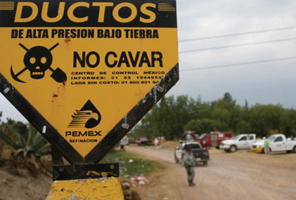
Pemex pipeline danger sign
Pemex pipeline warning sign. Credit Revista Buzos

The areas at risk are in the Deportiva, Hugo Mayoral, San Pablo Norte and San Pablo Sur districts (colonias) of Salina Cruz. Besides the homes, there are also vehicle repair shops, restaurants and even a shopping center in the zone along the pipelines.

In Coatzacoalcos, Veracruz, near another Pemex refinery called Pajaritos, a small town called Mundo Nuevo has sprung up to house construction and refinery workers. Its 20,000 residents live in close proximity to no fewer than 26 pipelines entering and leaving the refinery and, according to this report from  Jesús Lastra Ríos, they are not even certain of what materials are being carried in the pipelines, let alone their toxicity, flammability and explosiveness. In this case, apparently, the state “risk atlas” includes details of the pipeline diameters, but not their contents.

Clearly, settlements of any kind should not be allowed so close to Pemex pipelines, but there are many similar instances in Veracruz, as there are in many other states.

In Hidalgo state recently, the Education Ministry identified three schools as having been built “in high-risk areas near Pemex pipelines”. The state is making emergency plans to relocate the schools at an estimated cost of around $5 million. The schools are in the municipalities of Villa de Tezontepec, Ajacuba and Tlaxcoapan. The Hidalgo state government has a “risk atlas” covering landslide and other risks, but, apparently, most existing maps are based mainly on events that have already occurred.

These three examples serve to illustrate the seriousness of the situation in many parts of Mexico where planning restrictions have not been effectively enforced, and where risk assessments permitting accurate mapping of the most vulnerable areas have still not been completed and are therefore not available to municipal or state authorities.

Related posts:

To read more about the geography of hazards in Mexico, use the “Hazards” tag: http://geo-mexico.com/?tag=hazards

Natural hazards in Mexico are discussed in detail in chapters 2, 4 and 7 of Geo-Mexico: the geography and dynamics of modern Mexico.

Mexico City: attracting businesses from northern Mexico and revitalizing downtown core

 Mexico's geography in the Press  Comments Off on Mexico City: attracting businesses from northern Mexico and revitalizing downtown core
Sep 262011
 

Some businesses leaving northern Mexico and moving to Mexico City

According to Laura Velázquez, the Economic Development Secretary for the Federal District, the city has attracted 1650 firms from the north of Mexico in the first six months of 2011. The Federal District does offer some financial incentives for newly established companies, but the main reason is believed to be that the firms see Mexico City as having a higher level of public safety than some of the cities in states such as Nuevo León, Chihuahua, Coahuila, Durango and Sinaloa in northern Mexico,

A diverse range of businesses is involved; most are relocating in the northern and eastern sectors of Mexico City. The migration has boosted the number of available jobs in Mexico City and also led to an increase in foreign investment.

The continued face-lift of Mexico City’s historic downtown core

We introduced the on-going renovation project to beautify Mexico City’s Historic Center in The revitalization of Mexico City’s historic downtown core. The Trust Fund set up to rejuvenate Mexico City’s Historic Center repaired and cleaned more than 1000 facades between 2007 and 2010, with a total street frontage of 11.24 km. The work is part of the renovation of Mexico City’s Historic Center which now looks better than ever! Work continues on many other buildings that still require attention.

Cycle taxis becoming a popular means of transport in city center

Cycle taxis or pedicabs (bicitaxis) have become a much more common sight in downtown Mexico City. Less than three years after their introduction, they are now carrying about 180,000 passengers a year, according to an official of Mexico City’s Historic Center Trust Fund. The vehicles were introduced as part of the Trust Fund’s efforts to revitalize the historic downtown core of Mexico City. They help to reduce the city’s CO2 emissions. There are currently 132 licensed cycle taxis operating in the downtown area. They combine pedal power with small electric motors. Their “drivers” double as informal tour guides. Each cycle taxi is about 3 m (10 ft) long.

Other posts related to Mexico City

Update on Mexico and the UN Millennium Development Goals (MDGs)

 Mexico's geography in the Press, Updates to Geo-Mexico  Comments Off on Update on Mexico and the UN Millennium Development Goals (MDGs)
Sep 222011
 

In a previous post, we looked at Mexico and the UN Millennium Development Goals. This post is the text of a press release issued by the President’s Office in September 2011:

As part of the celebrations of the 50th Anniversary of the United Nations Development Program (UNDP), President Felipe Calderón gave the General Administrator of the Program, Helen Clark, Mexico’s report on the progress achieved in the Millennium Development Goals.

He highlighted the influence of UNDP in Mexico which, throughout its existence, has contributed to the alleviation of poverty and inequality, sustainable human development, the prevention of risks from natural disasters, the implementation of environmental policies and the promotion of democracy.

The main achievements highlighted by the president, regarding the fulfillment of the Millennium Goals, were: achieving universal coverage in primary education, eliminating the education gap between men and women, which eradicated the gender gap in education and increased female empowerment, improvements in the population’s living conditions, through the reduction of mortality and child malnutrition, the sustained increase in life expectancy and specialized care for expectant mothers, the expansion of access to the population’s health services, in which he declared that by the end of this year, universal coverage will be achieved, and the expansion of access to basic services such as safe drinking water, information technologies, communication and decent housing.

The main challenges to be met, said the president, were the alleviation of poverty, improvements in the per capita income and the reduction of the inequality gap. However, he also expressed confidence that they would be fully met in a timely fashion, since he confirmed the fact that the authorities are working continuously to achieve the universalization of pre-school and secondary education, improve the quality of education and improve the Human Development Index through successful programs such as Opportunities and the Popular Insurance Scheme.

The president ended by confirming his commitment to enabling Mexico to fully achieve the values, ideals and agenda set by UN in a timely fashion.

[This post is the text of a press release issued by the President’s Office in September 2011)

Is poverty in Mexico on the rise?

 Mexico's geography in the Press  Comments Off on Is poverty in Mexico on the rise?
Sep 062011
 

According to a recent government study, almost half of Mexico’s population now lives in poverty. The report came from the National Political and Social Development Commission (Spanish language acronym: Coneval). Poverty rates had been falling for several years, so this is clear evidence that Mexico’s economy has been struggling in the wake of the economic recession in North America.

How does Coneval define poverty?

Coneval uses a simple multidimensional poverty index, which considers the following criteria:

  • household income
  • access to education
  • access to food
  • access to health care
  • access to social services
  • housing quality
  • access to basic household services (electricity, water, drainage)

According to Coneval, people living on less than 2,114 pesos (about $180) a month in urban areas (or 1329 pesos in rural areas) and who lack at least one of the basic social rights in the list are living in poverty.

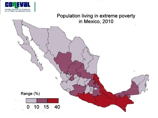
Extreme poverty (see map)  is applied to people living on less than 978 pesos ($85) a month in urban areas (684 pesos in rural areas) and lacking at least one social right.

Map of extreme poverty in Mexico 2010By these definitions, 46.2% of Mexico’s population (or about 52 million people) are currently living in poverty. This has risen from 44.5% in 2008. However, the percentage living in extreme poverty has dropped slightly since 2008 from 10.6% to 10.4%.

The distribution of poverty shown on the map above is not a surprise; we have seen many times in previous posts that the southern half of Mexico (excluding the Yucatán Peninsula) is much less wealthy in economic terms and social indicators than the north, even if it has a wealth of indigenous groups and cultural traditions.

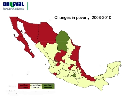
The map below is perhaps more interesting since it highlights the areas where the incidence of poverty has changed significantly between 2008 and 2010. The green areas have experienced a significant decrease in poverty and the red areas a significant increase in poverty. It is clear that the effects of the economic recession are being felt much harder in northern Mexico, where export-led manufacturing is prominent, than in the south.

map of changes in poverty in Mexico, 2008-2010Poverty in Mexico is on the rise, and it is on the rise faster in northern Mexico than the already poverty-stricken south. Only time will tell whether this increase in poverty is a temporary and short-lived trend or whether it heralds the start of tough times for many people in Mexico, especially those living in the rural areas, where the incidence of poverty and extreme poverty are far higher than in urban areas.

Given that the income levels used to define poverty in urban areas are more generous than those used for rural areas, the true level of poverty in the Mexican countryside is almost certainly much higher than this study suggests, something for politicians to bear in mind as they gear up for national elections next year.

Related posts:

Car-makers building new assembly plants in Mexico

 Mexico's geography in the Press  Comments Off on Car-makers building new assembly plants in Mexico
Aug 232011
 

Two major Japanese car-makers—Mazda and Honda—have announced expansion plans in Mexico in recent months. They will help ensure that Mexico remains the 9th largest car manufacturer in the world, and the 6th largest vehicle exporter. In addition, Italian auto-maker Fiat is expanding its plant in Toluca.

Mazda plant in Salamanca

Mazda is building a new 500-million-dollar plant in Salamanca (Guanajuato) to assemble its best-selling Mazda2 and Mazda3 models. The Mazda3 is the Mazda’s top selling model in the USA. The Mazda plant, scheduled to open in 2013, will employ about 3,000 workers and produce 140,000 vehicles a year.

Honda plants in El Salto and Celaya

Honda, which currently has two manufacturing plants in El Salto (Jalisco), is to construct a third plant, in Celaya (Guanajuato). The new plant will produce the fuel-efficient Honda “Fit” for the North American market. Due to open in 2014, it represents an investment of 800 million dollars and will have the capacity to assemble 200,000 vehicles a year.

Mexican-made cars being exported to China

By early next year, Fiat will be producing 100,000 units a year of its model 500 at its new plant in Toluca, in the state of Mexico. Only 3.5% of these units will be sold in the domestic market. The remainder are destined for export markets, including China, Brazil and the USA. China has already received its first shipment of 100 exclusive “First Edition” vehicles and is expected to take 50,000 a year once the Fiat plant is operating at full capacity.

Related posts:

Mexico’s economic geography is analyzed in chapters 14–20 of Geo-Mexico: the geography and dynamics of modern Mexico. Buy your copy of this invaluable reference guide today!

Aviation history as Mexico’s Aeroméxico uses biofuel for transatlantic passenger flight

 Mexico's geography in the Press  Comments Off on Aviation history as Mexico’s Aeroméxico uses biofuel for transatlantic passenger flight
Aug 132011
 

Aeroméxico, Mexico’s major international airline, made aviation history in July. Aeroméxico flight AM1, from Mexico City to Madrid, was the first ever commercial transatlantic passenger flight using bio-fuel. The Boeing 777 flew on a mixture of biofuel and regular jet fuel. Earlier this year, another Mexican airline, Interjet, began using renewable jatropha-based biofuel for flights between Mexico City and Tuxtla Gutierrez in the southern state of Chiapas. Jatropha is a genus of plants, mainly shrubs, that grow wild in several parts of Mexico, including Chiapas. Plantations of jatropha require four or five years of cultivation before the plant is sufficiently mature for commercial harvesting.

Jatropha-based biofuel is marketed as “green jet fuel” and is currently significantly more expensive than regular jet fuel. However, the price of biofuel is expected to fall rapidly as more of it is produced. The “life-time” emissions from using jatropha (including its growing period, processing and combustion) are estimated to be at least 60% less than using conventional jet fuel.

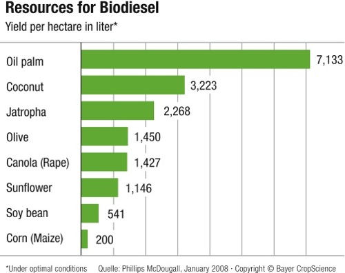
Sources of biodiesel.

Sources of biodiesel. Credit: Bayer CropScience

Mexico’s aviation sector will need 40 million liters of biofuel a year by 2015 in order to meet the national target of 1% of all airline fuel coming from renewable sources. The aviation industry’s long-term target is to halve its 2005 carbon footprint by 2050.

Despite Mexico’s recent adoption of jatropha-based biofuel, there is considerable controversy about the plant’s real value as a sustainable source of renewable energy. See, for example, the critique “Hailed as a miracle biofuel, jatropha falls short of hype” on Yale Environment 360, a publication of the Yale School of Forestry & Environmental Studies.