Tracking the migratory routes of Mexico’s sea turtles

 Other  Comments Off on Tracking the migratory routes of Mexico’s sea turtles
Jun 302014
 

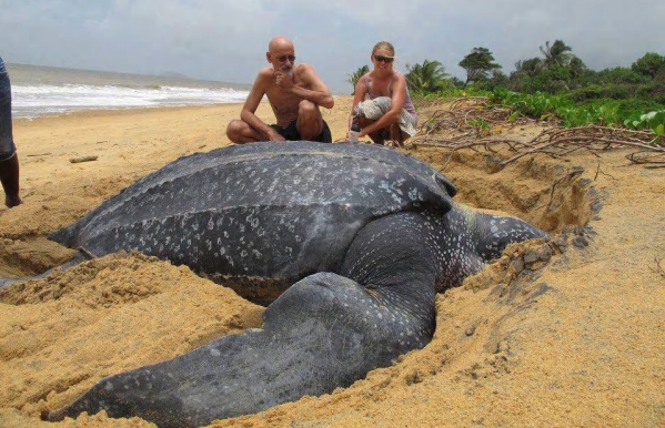
The Wildlife Protection and Conservation Program at the CIIDIR Sinaloa campus of Instituto Politécnico Nacional (National Polytechnic Institute), has developed a series of research projects focusing on sea turtle conservation in northwest Mexico. For one of their projects, researchers released (on the Playa Las Glorias beach in the city of Guasave) three sea turtles who can now be tracked using satellite tracking devices affixed to their shells. The main purpose is to allow researchers to determine the sea turtles’ migration routes.

leatherback-turtle

These three Loggerhead sea turtles (Caretta caretta) now carry transmitters that are connected to the ARGOS satellite system. This should enable their location to be closely tracked for at least a year. The migration of these three sub-adult Loggerhead turtles – named Umi, Baawe and La Hija del Señor – can be followed via the Seaturtle.org website:

These sea turtles nest in Japan, but then migrate to the coasts of Hawaii and Mexico to feed and develop. Experts say that they will only migrate back to Japan once they have reached sexual maturity.

This research is only one of many that involves tracking sea turtles. Off the Gulf Coast of Mexico , a longer-established study has sought to determine the movements of Kemp’s Ridley turtles (Lepidochelys kempii), many of which nest in Tecolutla, Veracruz. These turtles nest an average of 2.5-3.0 times per season, and tracking their movements should help predict where and when the turtles might nest, helping conservationists identify and protect nesting sites.

Related posts:

Study finds indigenous Mexicans far more diverse than previously thought

 Other  Comments Off on Study finds indigenous Mexicans far more diverse than previously thought
Jun 262014
 

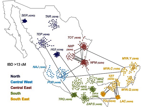
A recently released study [1] indicates that genetic diversity among indigenous Mexicans is far greater than previously thought. Ethnic Seri living in isolated parts of Sonora are as genetically different from isolated Lacandon living near the Guatemala border as Europeans are from Chinese. These differences must have existed for thousands of years before Europeans arrived in the New World. The differences are also reflected in mestizos living in geographically separated parts of Mexico.

Source: A. MORENO-ESTRADA ET AL., SCIENCE (2014)

Source: Moreno-Estrada et al. Science (2014)

The study in the June 13 issue of Science was conducted by researchers from the University of California, San Francisco and Stanford. They studied the genomic data from 511 native Mexicans from 20 of Mexico’s 65 indigenous groups scattered throughout Mexico (see map) from the Seri (SER) and Tarahumara (TAR) in the northwest, to the Purépecha (PUR) in the west, Trique (TRQ) and Zapotec (ZAP)in the south as well as three subgroups of Maya (MYA) on the Yucatán Peninsula [2]. They also analyzed similar data from 500 mestizos from ten Mexican states as well as some from Guadalajara and Los Angeles.

The findings have great implications for the study of diseases in these populations [3]. For example a lung capacity test can indicate a disease in one indigenous group while the same test results would be normal in a different indigenous group.

References:

[1] Moreno-Estrada et al. “The genetics of Mexico recapitulates Native American substructure and affects biomedical traits”, Science 13 June 2014; Vol 344 no.6189, p. 1301.

[2] Lizzie Wade. “People from Mexico show stunning amount of genetic diversity”, ScienceMag.org, June 12, 2014.

[3] Karen Weintaub,”Mexico’s Natives didn’t mix much, new study shows”, National Geographic, June 12, 2014.

Related posts:

Back to the drawing board for US-Chinese tourism project near Cabo Pulmo

 Mexico's geography in the Press  Comments Off on Back to the drawing board for US-Chinese tourism project near Cabo Pulmo
Jun 232014
 

Good news for Cabo Pulmo, the marine park in Baja California Sur! Cabo Pulmo is a 7,111-hectare (17,550-acre) marine reserve that boasts the best-preserved coral reef in Mexico’s Pacific region. The proposed tourist megaproject known as Cabo Dorado on the edge of the park has been shelved, at least for now.

The US-Chinese joint venture behind Cabo Dorado said it is halting plans to build the tourist development due to the “well-founded” criticism of environmental groups. [See New threat to Cabo Pulmo National Marine Park] The $3.6 billion project was to have included construction of thousands of hotel guestrooms in the area where another giant development project, Cabo Cortés, had been planned. The Cabo Cortés project was cancelled by government officials on the grounds of environmental concerns.

The firms behind Cabo Dorado are Glorious Earth Group (USA) and Beijing Sansong International Trade Group (China), together with China State Construction Engineering Corporation. The initial proposal was for a project involving the construction of a new “ecotourist city” on 3770 hectares (9317 acres) of land, including 6,141 homes,9 hotels, 2 golf courses, a landing strip, shops and a convention center.

The group has now halted its initial environmental-impact study of the Cabo Dorado project, with the intention of resuming this procedure in the near future with a new project “that meticulously takes into account the well-founded criticisms that have been expressed and which we’ve listened to carefully and with the utmost respect”.

Related posts:

Medical tourism and the medical equipment industry in Mexico

 Other  Comments Off on Medical tourism and the medical equipment industry in Mexico
Jun 212014
 

Mexico is both a growing market for medical tourism and a world leader for the manufacture of medical equipment.

Growing market for medical tourism

The global market for medical tourism in 2013 was estimated to be worth about $2.847 billion, with some 7 million patients seeking medical treatment outside their home country each year. According to Patients without Borders, a U.S. business that specializes in the field, Mexico is currently the second most popular destination for medical tourists, after Thailand. Nationwide, Mexico has more than 71,000 doctors working in hospitals and private clinics. Almost two-thirds of all doctors in Mexico are specialists, compared to an average of 57.7% for all OECD member nations.

Mexico’s Economy Secretariat estimates that, combined, the one million medical tourists in 2013 and the numerous affiliated services such as spas, massages and non-conventional therapies, contributed $4.2 billion to the national economy. This figure is growing at about 7% a year.

Patients without Borders claims that patients from the USA and Canada pay between 36 and 80% less for operations and medical treatments in Mexico than the cost in their home country. The most important states for medical tourism are Nuevo León, Baja California, Baja California Sur, Sonora, Tamaulipas, Chihuahua, Jalisco, Quintana Roo and Yucatán.

A plan to build a new “medical city” has been announced by health officials in Quintana Roo. It would be called “Jardines de la Sabiduría” (Gardens of Wisdom) and located on a 550-hectare lot between Cancún and Puerto Morelos. The new city would have four zones: residential, hospitals, recreation and cultural/educational, and would include at least four hospitals: for children, cancer care, dental work and orthopedic surgeries respectively. It remains to be seen if sufficient foreign investment can be found to bring this project to fruition.

World leader for medical equipment

Mexico is a major manufacturer of medical devices. Sales of Mexican-made medical equipment exceed $10.6 billion a year and are predicted to reach $14.9 billion by 2020. Manufacturing costs for medical devices in Mexico average 25% below those in the USA, the world’s largest market for such products.

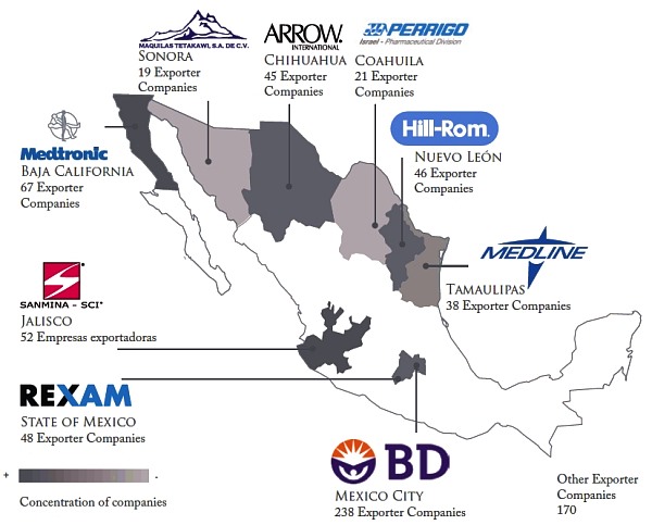
Major medical device manufacturing areas in Mexico

Major medical device manufacturing areas in Mexico. Credit: Economy Secretariat.

Mexico’s exports of medical equipment and supplies were worth $6.2 billion in 2011, making Mexico by far the largest exporter of medical devices in Latin America, and the 11th largest in the world. 92 % of medical devices manufactured in Mexico are exported to the USA, accounting for two-thirds of all U.S. imports of those products.

According to Pro-Mexico, Mexico is the world’s largest exporter of bore needles; the 4th largest exporter of medical, surgical, dental and veterinary furniture; the 5th largest exporter worldwide of medical,surgical, dental and veterinary instruments and apparatus; and the 7th largest exporter worldwide of ozone therapy, oxygen therapy, aerosol therapy apparatus, breathing apparatus and other respiratory therapy apparatus.

More than 2,000 separate businesses, and about 135,000 workers help invent, design and manufacture medical devices in Mexico. Medical device manufacturing is concentrated mainly in northern border states, especially Baja California, where the cluster of more than 60 specialist firms includes Smiths, Tyco Healthcare, Cardinal Health, Medtronic, Gambro, ICU Medical, CLP, Sunrise Medical and North Safety Products.

Data:

  • The Medical Device Industry, 2012 (Pro-Mexico; pdf file)

Related posts:

Common errors of Mexican geography #2: confusing the Sierra Madre with the Volcanic Axis

 Other  Comments Off on Common errors of Mexican geography #2: confusing the Sierra Madre with the Volcanic Axis
Jun 192014
 

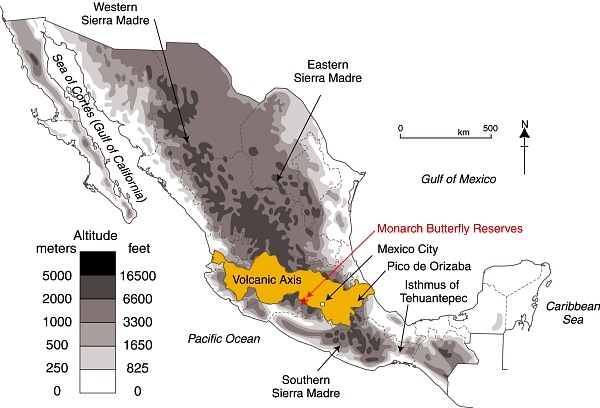
Describing somewhere in Mexico as being “located in the Sierra Madre mountains” may conjure up images of high, possibly snow-capped peaks and rugged scenery, but does very little to pin down the location. Mexico has several Sierras Madre (literal translation: Mother Ranges). The three main Sierra Madre regions in Mexico are the Western Sierra Madre, Eastern Sierra Madre and Southern Sierra Madre (see map).

The Western Sierra Madre (Sierra Madre Occidental) is the youngest, highest and most viciously dissected of the three. This region includes the scenically amazing Copper Canyon region we have described in many previous posts, including:

Location of Volcanic Axis and Monarch Butterfly reserves

Location of Volcanic Axis and Monarch Butterfly reserves. Basemap: Figure 3.1 of Geo-Mexico; all rights reserved.

The Western Sierra Madre extends only as far south as the states of Nayarit and Jalisco.

Its counterpart on the eastern side of the country is the Eastern Sierra Madre (Sierra Madre Oriental) which is older, lower and less rugged. Between these two major mountain ranges are mid-elevation basins and plains.

At the southern end of both the Western Sierra Madre and the Eastern Sierra Madre is the Volcanic Axis.

The Southern Sierra Madre (Sierra Madre del Sur) lies south of the Volcanic Axis, largely in the state of Oaxaca.

The details of Mexico’s physiographic regions are complex, but the basic relief pattern of these three Sierra Madre regions, separated by the Volcanic Axis and mid-elevation basins and plains, is fairly simple. It is therefore disappointing when we read references to the Sierra Madre regions that are geographically inaccurate.

The Monarch Butterfly reserves, for instance, are regularly described as being in the Sierra Madre, or the Western Sierra Madre, even though they are located hundreds of kilometers away from the Western Sierra Madre, on the southern edge of the Volcanic Axis (see map). In the original National Geographic article about the “discovery” of the Monarch Butterflies’ overwintering sites (August 1976), the location of the butterflies was deliberately left vague (to prevent human-induced disruption of the sites), so that article can readily be excused for mislocating the sites as being in “Mexico’s Sierra Madre”. (The tiny map that accompanied that article also shifted the Monarch’s wintering areas well away from their real position.)

Despite the efforts of the National Geographic, it was not long before journalists published articles giving the precise locations of the sites, and visitors started to flock to see this marvel of nature. The establishment of reserves has now brought a measure of sanity and control to access and most visitors now behave respectfully.

One of the latest in the long line of journals and magazines to erroneously refer to the site of the Monarch reserves as “in the remote Sierra Madre mountains” (but lacking the original excuse of the National Geographic) is the Canadian Geographic in its December 2013 Annual Wildlife Issue. The general tone of the article is helpful, and it rightly emphasizes the need to protect habitat along the entire migration route between Canada and Mexico, so why mar the overall quality by making such a basic error of Mexican geography? Let’s help educate readers by making it clear that the Monarch Butterfly reserves are not in any Sierra Madre, but are in the Volcanic Axis!

Monitoring air pollution in Guadalajara

 Books and resources, Teaching ideas  Comments Off on Monitoring air pollution in Guadalajara
Jun 162014
 

Air pollution in the city of Guadalajara, the state capital of Jalisco, has worsened over the past decade, though there are some recent signs of improvement :

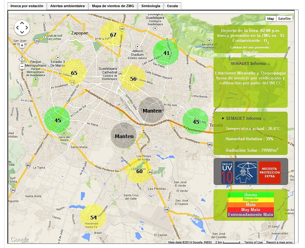
The Jalisco Environmental Agency now has a webpage where residents and travelers alike can now monitor Guadalajara’s air quality on an hourly basis. Readings for 10 stations are superimposed on a basemap on that page, together with links to graphs showing recent trends and other meteorological data. Tabs above the map also give a link to the current wind conditions across the city. Historical data (in Spanish) can also be accessed via the link to “Datos”.

Screenshot of Guadalajara air monitoring webpage

Screenshot of Guadalajara air monitoring webpage. Note: Two stations are shown as undergoing maintenance.

The map provides summary data in IMECAs, which stands for Índice Metropolitano de la Calidad del Aire (Metropolitan Index of Air Quality). IMECAs are a compound index combining measurements of concentrations of ozone (O3), sulphur dioxide (SO2), nitrogen dioxide (NO2), carbon monoxide (CO) and particles smaller than 10 micrometers (PM10).

In Guadalajara, formal smog alerts are issued if average readings rise above 150 IMECAs (“Very Bad”) for more than two consecutive hours. If readings rise above 200 IMECAs (“Extremely Bad”), then “serious alerts” impose restrictions on vehicle use and may lead to the suspension of school classes.

In Guadalajara, the worst air quality tends to be in the southern and eastern sections of the city. It also tends to occur in the months of April and May, immediately before the rainy season gets underway. The webpage system gives everyone an easy way to check these assertions!

In Guadalajara, mitigation efforts are centered mainly on reducing vehicle emissions (partly by stricter emissions testing and verification, and partly by improvements to the public transport network) since they are the main source of pollution. To date, there are no plans in Guadalajara to introduce a “Day without car” program similar to that in Mexico City:

Teaching idea

Use the Jalisco Environment Agency webpage to monitor Guadalajara’s air pollution and identify any patterns or trends related to air pollution in the city. Consider suggesting one or more hypotheses, such as “Air pollution gets worse in the afternoon”, or “The level of air pollution in eastern Guadalajara is worse than in western Guadalajara”, before testing your ideas using the online data.

Related posts:

Mexico is home to two of the world’s largest cinema multinationals

 Other  Comments Off on Mexico is home to two of the world’s largest cinema multinationals
Jun 142014
 

The Mexican business press consistently describes Mexico’s movie-going industry as being divided between two major players: Cinépolis, the fourth largest cinema chain in the world, and Cinemex, now the world’s sixth largest cinema company. It should be noted that their world rankings lack independent verification.

Cinépolis

cinepolis-logoCinépolis (“City of Cinema”) has 2456 screens in Mexico, giving it a 48% share of the domestic market. The chain consists of 205 theaters in 65 cities in Mexico, and more than 230 movie theaters and 3,000 screens worldwide, with a presence in Mexico, Guatemala, El Salvador, Costa Rica, Panama, Colombia, Brazil, Peru, India and the USA. It is Latin America’s largest movie theater chain.

The company began in 1947 in Morelia, Michoacán, as “Cine Morelos”. Rebranded several times, the company began expansion by opening theaters in nearby Salamanca, Acámbaro and Guanajuato, before entering the Mexico City market in the early 1970s. The brandname Cinépolis was first used in the mid 1990s, spawning the up-market Cinépolis VIP brand (luxury cinema with reclinable seats and service), in 1999.

Cinépolis extended its operations outside Mexico, first to capital cities in several Central American countries, including Guatemala, El Salvador, Costa Rica and Panama, and is now expanding into South America.

Cinepolis has also entered the lucrative Indian market, with mid-term plans to operate 500 screens in that country.

Cinemex

cinemex-logoCinemex, after its recent acquisition of smaller competitor Cinemark, has a 42% share of the domestic market.

Cinemex has a total of 2,359 screens in 264 locations across Mexico, an astonishing increase from the 44 locations it had in 2007, and now serves 78 million moviegoers a year.

Cinemex started with a college business plan focused on the provision of larger movie theaters. The first Cinemex theaters were opened in Mexico City in 1995. Within a few years, the chain had added cineplexes in Guadalajara, Monterrey, Toluca, Cuernavaca and Puebla. In 2013, it opened Mexico’s X4D theater, in Santa Fe, Mexico City.

Related posts:

Country groupings: BRICs, EAGLEs and now MINTs

 Mexico's geography in the Press  Comments Off on Country groupings: BRICs, EAGLEs and now MINTs
Jun 122014
 

Economists have long suggested various sub-groupings of emerging markets. One of the most commonly used in geography is BRIC, an acronym formed from the initial letters of Brazil, Russia, India and China. The term BRIC was first coined by  Jim O’Neill in a 2001 paper entitled “The World Needs Better Economic BRICs”. The concept of BRICs has become outdated as the four countries’ economies have diverged over the past decade.

Next on the scene was the term EAGLEs to cover the world’s Emerging and Growth-Leading Economies. The advantage of this acronym is that it is not tied to specific countries. Any term comprised of country names is likely to date fairly quickly, and become much less useful. The members of the EAGLEs club are currently:

  • Brazil
  • China
  • Eqypt
  • India
  • Indonesia
  • Mexico
  • Russia
  • South Korea
  • Taiwan
  • Turkey

Combined, these ten EAGLEs are  expected to account for 50% of all global growth that occurs over the next 10 years.

The four MINT countries

The four MINT countries

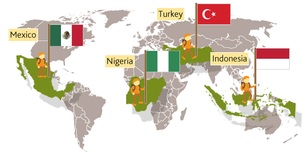
Jim O’Neill has recently popularized another contribution to the terminology of countries believed to be emerging market giants: MINTs. The term was originally coined by Fidelity Investments. The four members of this exclusive grouping are:

  • Indonesia
  • Mexico
  • Nigeria
  • Turkey

In proposing the new grouping, O’Neill makes a compelling case for Mexico’s future economic success. First, its large population ensures a viable domestic market. It also has a growing middle class and a steadily improving dependency ratio (the number of working age people compared to those not working). In addition, Mexico has a privileged position in world trade, linking North America to Asian markets. O’Neill believes that Mexico could experience double-digit rates of economic growth in the coming years, with GDP/person rising from its current figure of about 11,000 dollars to 48,000 dollars by 2050.

Related posts:

Mexico’s 15 physiographic regions

 Excerpts from Geo-Mexico  Comments Off on Mexico’s 15 physiographic regions
Jun 092014
 

The relief and landforms of Mexico have been greatly influenced by the interaction of tectonic plates.

The resulting relief patterns are so complex that it is often claimed that early explorers, when asked to describe what the new-found lands were like, simply crumpled up a piece of parchment by way of response.

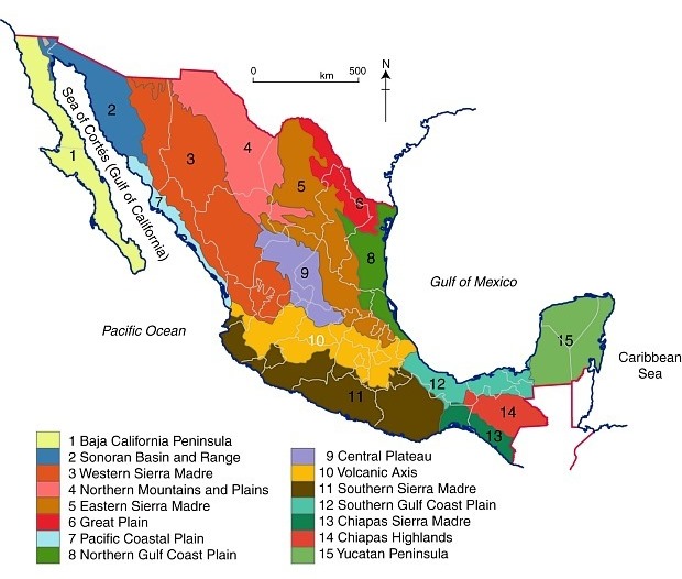
The map below shows Mexico’s main physiographic regions. The core of Mexico (both centrally located, and where most of the population lives) is the Volcanic Axis (Region 10 on the map), a high plateau rimmed by mountain ranges to the west, south and east. Coastal plains lie between the mountains and the sea. The long Baja California Peninsula parallels the west coast. The low Isthmus of Tehuantepec separates the Chiapas Highlands and the low Yucatán Peninsula from the rest of Mexico.

Mexico's physiographic regions

Mexico’s physiographic regions. Color version of Figure 3.2 of “Geo-Mexico, the geography and dynamics of modern Mexico”; all rights reserved.

We looked in more detail at the Volcanic Axis in several previous posts, including

and will look more closely at some of the other physiographic regions in later posts.

The regional geography of tacos

 Books and resources  Comments Off on The regional geography of tacos
Jun 072014
 

A taco is a corn or wheat tortilla folded or rolled around other edible ingredients, and designed to be eaten by hand – the indigenous Mexican equivalent of a sandwich. Tacos are extremely versatile and often accompanied by garnishes such as tomatoes, onions, lettuce, radishes, and avocado or guacamole, topped with salsa and cilantro.

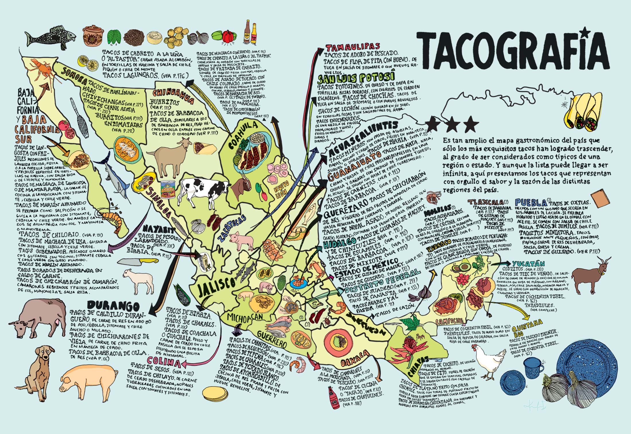
Who would have thought that the humble taco was worth its own encyclopaedia? This particular encyclopaedia includes a fascinating graphic – a map (see graphic) summarizing the different regional varieties of taco commonly found in different parts of the country.

The accompanying terminology used to describe all these tacos is mind-blowing, but a small sampling will give you the idea:

Regional varieties of Mexican tacos

Regional varieties of Mexican tacos. Credit: La tacopedia. Enciclopedia del taco (Spanish Edition) . Click to enlarge.

The map is by no means an exhaustive list, but does include examples of taco specialties for every state.

The two states occupying the Baja California Peninsula both have seafood-based tacos:

  • Baja California – tacos de langosta con frijoles (lobster and beans tacos)
  • Baja California Sur – tacos de marlin ahumado (smoked marlin tacos)

The tacos popular in some states reveal less about their ingredients:

  • Aguascalientes – tacos mineros (miner’s tacos)
  • Coahuila – tacos laguneros (Laguna region tacos)
  • Morelos – tacos acorazados (battleship tacos)
  • Puebla – taquitos miniatura (miniature tacos)

For some unusual ingredients, try:

  • Chiapas – tacos de hormiga chicatana (flying ant tacos)
  • Colima – tacos de sesos (brain tacos)
  • Hidalgo – tacos de gusanos de maguey (maguey worm tacos)
  • Yucatán – tacos de tzic de venado (shredded venison tacos)

Feeling daring? Try the tacos envenenados in Zacatecas. The literal meaning is “poisoned tacos”, but they are apparently named so as not to reveal all their ingredients!

Tacos have become incredibly popular. While they predate the Spanish conquest, they are now well on their way to conquering large swathes of North America and Europe.

The regional patterns is analyzed further by Frank Jacobs in 604 – A Tacography of Mexico

For more about tacos, we recommend reading La tacopedia. Enciclopedia del taco by Deborah Holtz and Juan Carlos Mena (Trilce Ediciones, 2012).

Related posts:

Jun 022014
 

This engaging book analyses the historical geography of the port of San Blas, on Mexico’s west coast, and its hinterland which includes the small city of Tepic, the state capital of Nayarit. This area held immense importance during colonial times, was one of the main gateways for trade and influence peddling during the nineteenth century, before lapsing into relative obscurity at the end of the that century, and into the twentieth century. The tourism industry has sparked a mini-revival but none of the many grandiose plans for this coast have even been brought fully to fruition.

richter-coverThe Camino Real in Richter’s title is actually a branch from the Camino Real de Tierra Adentro (The Inland Royal Road, the spine of the colonial road system in New Spain). During colonial times, this linked the inland city of Guadalajara to Tepic and thence San Blas, though the modern highways uniting these places no longer follow the same route.

Robert Richter has known this area personally for decades, and his intimate knowledge of the local geography shines through. The book combines his own personal experiences with intensive historical research, both in the library and on the ground. Richter’s objective is to pin down the precise route of the Camino Real, and then find every remaining vestige of it that he can on the ground.

In reading the story of San Blas and the Camino Real, readers are treated to a dazzling array of insights into what made this area tick for so long before subsiding into something of a backwater. This branch of the Camino Real, from Guadalajara to San Blas, played a key role in the history of Western Mexico, and saw everything from pirates and adventurers to soldiers, priests and smugglers.

As Richter points out, “The Matanchen Bay-San Blas region grew in geographic and strategic importance to become the most important Pacific seaport between Guayaquil, Ecuador, and San Francisco, California, in the 1830s, a major international way station for both legal and contraband trade between an ungovernable Mexico and the rest of the world.”

This growth continued and, “In the 1850s, the cultural, economic, and political events roiling all along the Camino Real from San Blas to Guadalajara, especially in the mild sierra valley surrounding the city of Tepic, spawned a new regional identity, and eventually, a new political entity—the Mexican state of Nayarit.”

Richter tells his story with passion and it is impossible not to be drawn into the narrative and share his excitement as he sets out to find “missing” sections of the Camino Real, accompanied by a motley crew of secondary characters. To what extend does he succeed? Sorry, no spoilers here!

Inevitably, the past merges with the present and the future. What began as a seemingly straightforward historical geography becomes at turns a travelogue, journal of fieldwork and short essay about the sustainability of economic development along this coast. Richter is clearly not against change, but argues strongly that local tourist development in the future must take account and respect the region’s ecology, its history and its culture.

As the back cover blurb aptly states, “To explore Nayarit’s wild and gorgeous geography, trying to site the ancient Camino Real, is to stumble over another road running toward the state’s future economic development as part of the Mexican Riviera.”

This book should be of interest to geographers everywhere. It serves to prove that historical geography need not be dull and stuffy but can be made relevant, exciting and even entertaining, at the same time as it offers us valuable insights into possible futures.

One minor plea: please add an index when the second edition of this book is prepared!

Search for the Camino Real, a history of San Bad and the road to get there” is one of several books by Richter centered on the fading coastal village culture of Nayarit and the Mexican Riviera. His adventure novel, “Something like a Dream” (Oak Tree Press, 2014) is an especially entertaining read, with a lively plot and well-described settings ranging from the tourist resort of Puerto Vallarta to Nayarit fishing villages and tiny Huichol Indian settlements high in the Western Sierra Madre.

Map of the beaches of Colima, Jalisco and Nayarit, Mexico shows the location of all the key places mentioned in Richter’s books.

Related posts: