A Happy New Year to all our readers!

 Other  Comments Off on A Happy New Year to all our readers!
Jan 012015
 

We had no idea when we first published Geo-Mexico, the geography and dynamics of modern Mexico, and started this associated blog, how many readers we would reach.

Geo-Mexico-ThumbnailOn the one hand, very few U.S. or Canadian universities have courses devoted specifically to Mexico. There are quite a number of geography courses with titles such as “The Geography of Mexico, the Caribbean and Central America”, or “The Geography of Latin America”, but very few that focus mainly or solely on Mexico. This is unfortunate and means that most geography students graduating from USA universities will have only a partial knowledge, at best, of their southern neighbor. It also means that Geo-Mexico was not adopted by as many university courses as we might have hoped.

On the other hand, the book has been used in several courses that were not part of its target market, including courses in “The Politics of Mexico” and at least one International Affairs program. Equally, it has exceeded our expectations in providing a basic guide for non-specialists interested in getting a better knowledge of Mexico; the frequent feedback from readers has been overwhelmingly positive and gratifying. (Please keep it coming!)

The blog has proved to be very popular, and its audience continues to grow ~ don’t forget to recommend it to friends and colleagues. We welcome all comments and suggestions for future posts. We also welcome 400-800 word submissions (which will be published with your byline), but please contact us first.

Maps from Geo-Mexico have been included in many academic publications and a number of graduate theses. Publications that referred to the book, and/or blog, cover an amazing range of topics. A random sampling includes:

  • “Environmental risk, resilience and migration: implications for natural resource management and agriculture” in Environmental Research Letters  (2012)
  • “Texas and Mexico: Sharing a Legacy of Poverty and Neglected Tropical Diseases” in PLoS Neglected Tropical Diseases (2012)
  • “Zapatista Autonomy in Cartel Mexico: Preserving Smallholder Viability”, in Culture, Agriculture, Food and Environment (2011)
  • “NAFTA: The Mexican Economy, and Undocumented Migration” a research paper of Naval War College Newport, RI, Joint Military Operations Dept. (2011)
  • The Future of Entrepreneurship in Latin America (Palgrave Macmillan, 2012)
  • “Climate Change, Migration and Security, Best Practice Policy and Operational Options for Mexico”, an Interim Report from the Royal United Services Institute, Whitehall, London (2012)
  • “Vulnerability and Surviving Pattern of Elderly Migrants in Urban Mexico”, in Journal of Sociological Research (2012)
  • OECD Reviews of Risk Management Policies: Mexico 2013 Review of the Mexican National Civil Protection System (OECD 2013)

To all our readers, thanks for your support, and we wish you all a

Happy New Year! ¡Feliz año nuevo!

Seasonal greetings from Geo-Mexico!

 Other  Comments Off on Seasonal greetings from Geo-Mexico!
Dec 242014
 

Geo-Mexico wishes all its readers the warmest seasonal greetings.

tenango-de-flores-xmas-tree2

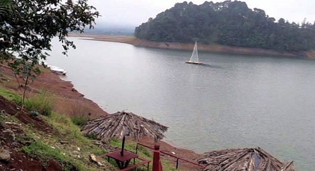
The photo shows Mexico’s only floating Christmas Tree. It can be seen near Tenago de las Flores in the municipality of Huachinango in the northern part of the state of Puebla. The 15-meter-high tree, with Christmas lights, stands on a wooden platform atop a raft of 32 metal drums in the middle of the Tenango reservoir, upstream from the Necaxa Dam, Mexico’s first hydroelectric project, dating back to 1905. The tradition started only three years ago when local residents decided that a floating Christmas tree might prove to be a tourist attraction.

The 10-min video below shows the “light up” of the tree early this month, complete with music and singing.

Tenango de las Flores has been more famous in the past for its large-scale production of flowers (floriculture) and for its annual Flower Festival, as well as for featuring in an award-winning 1957 film called Tizoc: Amor Indio, starring María Félix and Pedro Infante. The film won the Golden Globe Award for Best Foreign Language Film at the 15th Golden Globe Awards (1958).

tenango-de-flores-xmas-tree-day

Related posts:

The production of Christmas trees in Mexico

 Other  Comments Off on The production of Christmas trees in Mexico
Dec 182014
 

According to consumer surveys, only one out of every five Mexican households decorates a natural Christmas tree during the holiday season; the other 80% of households decorate artificial trees. About 75% of natural trees are bought from traditional retailers, with the remaining 25% purchased from informal street vendors. Almost all purchases of natural Christmas trees are made between 10 December and 25 December.

As of mid-December 2014, sales of trees are reported to be down on previous years. Retailers claim that the prices for imported trees (ranging from 330 pesos (about 25 dollars) for a 1-meter-high tree to 1,500 pesos (110 dollars) for a large tree) have led to greatly diminished demand. Prices for domestically grown trees range from about 100 to 1,000 pesos.

The total annual demand for natural Christmas trees is about 1.8 million. Mexico currently imports about 1 million trees a year, almost all from the USA and Canada. Annual imports are worth about $12 million. Imports are governed by strict standards, last revised in 2010, to ensure that no unwanted pests or diseases are brought into the country.

As of mid-December, at least 5500 trees had failed the health inspection at the border and had been returned to the USA. Officials from Mexico’s Federal Environmental Protection Agency (Procuraduría Federal de Protección al Ambiente, Profepa) identified several problems in shipments of Douglas Fir and Noble Fir trees. At Tijuana, one shipment of Douglas Fir was found to be infected a resin moth (Synanthedon sp.), and one with flatheaded fir borer (Buprestidae). In Mexicali, a shipment of Douglas Fir was infested with the Douglas-fir Twig Weevil (Cylindrocopturus furnissi), while in Nogales, imported trees were found to be accompanied by unwanted European Paper Wasps (Polistes dominula). None of these pests are normally found in Mexico.

Mexicali is the busiest border crossing in terms of Christmas tree imports, accounting for 35% of the total, followed by Tijuana (25%), Nogales (16%), Colombia (15%), Nuevo Laredo (4%), San Luis Río Colorado (3%), Reynosa (1%) and Puente Zaragoza-Isleta (in Chihuahua) (0.4%).

In the 1970s and 1980s, most natural Christmas trees sold in Mexico came from Mexico’s natural forests. Beginning in the 1990s, specialist Christmas tree nurseries and plantations were started.

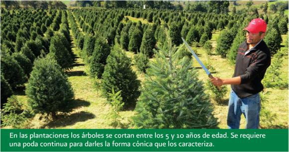
Pruning young Christmas trees in Mexico

Pruning young Christmas trees in Mexico to ensure they keep a good shape. Credit: CONAFOR.

According to the National Forestry Commission (CONAFOR), Mexico has almost 17,000 hectares of land planted in Christmas trees. The area of Christmas trees has increased very rapidly in recent years. This year, CONAFOR has provided some degree of financial assistance to farmers with 4,551 hectares of tree plantations in 18 states.

The main areas of Christmas tree plantations are in the interior highlands in the states of Mexico, Veracruz, Nuevo León, Mexico D.F., Puebla, Michoacán, Durango, Coahuila and Guanajuato. These states share temperate climate conditions and are close to the main markets in major cities.

The most common species grown in Mexico are Mexican White Pine (Spanish: Pino ayacahuite), Douglas Fir (Abeto douglas), Mexican Pinyon (Pino piñonero), Sacred Fir (Oyamel) and Aleppo Pine (Pino alepo).

Trees are harvested at between five and ten years of age. Mature plantations of Christmas trees can generate revenue of between 300,000 pesos and 500,000 pesos ($23,000-$38,000) for each hectare. This means that Christmas tree farming has become a profitable form of sustainable development in some rural communities, offering greater profit potential than using the same land to grow traditional rain-fed crops.

The planting of Christmas trees is supported by CONAFOR’s ProArbol program, which offers landowners incentives to conserve, restore, and sustainably exploit forest resources. CONAFOR claims this helps to limit urban sprawl, and counteract forest clearance for arable land, as well as to increase the capture and storage of carbon, thereby mitigating climate change. In addition, conifer plantations generate rural employment, reducing the effects of one of the key “push” factors behind rural-urban migration.

Note: This is an updated version of a post that was first published in 2012.

Main source:

USDA Foreign Agricultural Service GAIN report: Mexico: Christmas Trees, by Dulce Flores, Vanessa Salcido, and Adam Branson. 12 May 2011.

Related posts:

Dec 062014
 

In the second half of the 19th century, the Mexican government undertook am ambitious railway building program that eventually connected Mexico City with the USA, as well as with ports on the Atlantic Ocean and Pacific Ocean

Since the privatization of the railway system in 1995, many lines have fallen out of use and passenger services have been all but abandoned, leaving hundreds of kilometers of disused track and isolating some rural communities from the nearest large city. Much of Mexico’s historic railway infrastructure now lies in ruins.

In the past decade, some former railway lines have been turned into walking and cycling trails. For example:

The state of Jalisco has started to recondition 120 kilometers of former railway routes as Green Route (Via Verde) trails for non-motorized traffic (hikers, cyclists, horse riders). Many of the old stations along these routes will be restored to provide essential services and exhibition space. The former train station in Ameca (on the extreme northern edge of the town) has been renovated to serve as the start of one of these routes, with exhibits focusing on the history of the railroad, local fiestas and the region’s haciendas. The lovely building, dating back more than a century, witnessed its last train in 1995.

Given that the railways played such a key role in the Revolution, enabling both sides to move troops quickly around the country, it is fitting that they are now the basis for this new revolution involving cultural tourism. (Western Mexico, A Traveler’s Treasury, p 61).

Others lines, elsewhere in Mexico, have been explored by two intrepid Mexican artists as part of an unusual geo-art project. Artists Ivan Puig and Andres Padilla Domene built a vehicle capable of traveling on train tracks and explored some of the country’s abandoned railway lines. As they went, they photographed hundreds of ruins and recorded hours of interviews with people they met. They later did something similar in Ecuador, but that’s another story.

Their striking silver road-rail vehicle is known as SEFT-1, where SEFT stands for Sonda de Exploración Ferroviaria Tripulada (Manned Railway Exploration Probe).

seft-1

The artists recorded their experiences in videos, photographs and collected objects. Interviewing people they met, often from communities isolated by Mexico’s passenger railway closures, they shared their findings online, where audiences could track the probe’s trajectory, view maps and images and listen to interviews.

Their first London (UK) exhibition, SEFT-1 Abandoned Railways Exploration Probe – Modern Ruins 1:220, was commissioned by The Arts Catalyst and presented at the Furtherfield gallery space in the heart of Finsbury Park. In the exhibit, the artists explore how the ideology of progress is imprinted onto historic landscapes and they also reflect on the two poles of the social experience of technology: use and obsolescence.

For this exhibition, the artists also invited British expert model railway constructors to create scale reproductions of specific Mexican railway ruins exactly as they had found them. One gallery became a space for the process of model ruin construction. The room’s walls displayed the pictures, documents, plans and other materials used as reference for the meticulously-elaborated models.

The Artists

Ivan Puig (born 1977, Guadalajara) has exhibited internationally in Mexico, Germany, Canada, Brazil and the USA. Puig, a member of the collective TRiodO (with Marcela Armas and Gilberto Esparza), lives and works in Mexico City.

Andrés Padilla Domene (born 1986, Guadalajara) has exhibited work in Mexico, the USA and Ecuador. His video work as director and producer with Camper Media includes documentaries, fiction films and TV shows.

Related posts:

Nov 232014
 

Many of the arts and crafts found in Michoacán date back to pre-Columbian times, but now incorporate techniques and materials that were brought from Europe and elsewhere. Many of the introductions occurred during the time of Vasco de Quiroga (ca 1470-1565), after whom the town of Quiroga, at the eastern extremity of Lake Pátzcuaro, is named.

Visitors to Michoacán area often amazed to discover that towns even only a few kilometers apart have developed completely different handicrafts, and that all the handicraft workshops in any one town seem to focus on making precisely the same items. If one workshop in a town specializes in wooden items, all the neighboring workshops appear to do the same. Just how did these very distinctive spatial patterns come about?

Craft market in Tzintzuntzan, Michoacan

Craft market in Tzintzuntzan, Michoacan

The answer to the oft-asked question, “Why does each town in Michoacán have its own handicrafts?”lies in the history of this area and, in particular, of the efforts almost five hundred years ago of one Spanish priest.

Who was Vasco de Quiroga?

Vasco de Quiroga trained originally as a lawyer. He later took holy orders and arrived in the New World in 1531, already in his sixties. He gained rapid promotion and six years later was appointed Bishop of Michoacán, with the express purpose of trying to clear up the mess left by Nuño Beltrán de Guzmán’s rampage through western Mexico, and to placate the bad feelings of the indigenous Purépecha populace.

Vasco de Quiroga based his approach on the Utopian principles espoused by Thomas More. He established a series of communities in the vicinity of Lake Pátzcuaro, the heart of Purépecha country, improved security, and set up hospitals and schools serving the local people.

Agricultural improvements

Recognizing the importance of agriculture, Vasco de Quiroga introduced European implements and methods as well as new crops, including wheat and other cereals, fruits and vegetables. Perhaps his most noteworthy introduction was the banana. The first bananas to be grown anywhere in Mexico were brought by Vasco de Quiroga from Santo Domingo in the Caribbean and planted in Tzintzuntzan.

Handicrafts

Alongside religious instruction, Vasco de Quiroga organized training in arts and crafts. His efforts quickly won over many of the local people who came to acknowledge that the hostility they had experienced from their first contacts with Europeans was not typical of all the newcomers. The kindly Bishop came to be sufficiently respected by them to be awarded the honorific title of “Tata” (“Father”) Vasco.

The local indigenous Indians had already developed the skills needed for varied ceramics, wood and leather products, copper items, and woven cotton and agave fiber textiles. They also used the local lake bulrushes (tule). Vasco de Quiroga introduced new techniques which allowed the artisans to multiply their production.

To encourage specialization, and limit direct competition between villages, “Tata” Vasco allocated specific crafts to specific places, a pattern that continues to the present. The particular handicraft developed in each village also reflects the availability of local raw materials such as bulrushes needed for mats, or clay for pottery. On account of the fine quality of local clays, the making of ceramics was encouraged in the villages of Tzintzuntzan, Patamban, Santa Fe de la Laguna, Capula and Pinícuaro. Ironworking and locksmithing were introduced in San Felipe de los Hereros; quilting and embroidery in San Juan de las Colcahas, and so on.

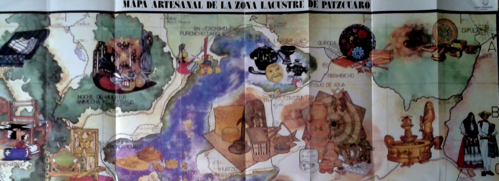
Section of tourist map showing some of handicraft towns near Lake Patzcuaro

Section of tourist map showing some of handicraft towns near Lake Patzcuaro

The arts and crafts skills in the villages around Lake Pátzcuaro and elsewhere in Michoacán have been passed down to this day, becoming more finely honed with each successive generation, producing craftsmen who are among the finest in the country. They are responsible for a truly amazing variety of handicrafts, fine art and furniture items.

Among the better known places to seek out particular handicrafts are:

  • Angangueo: woolen items
  • Cuanajo: wooden chests and furniture
  • Erongarícuaro: wooden furniture, earthenware
  • Ihuatzio: petate mats
  • Jarácuaro: palm hats (woven)
  • Paracho: guitars and stringed instruments
  • Pátzcuaro: wool, lacquer work, silver jewelry, toys, etc
  • Quiroga: painted trays and bowls, leather goods, wooden toys
  • Santa Fe de la Laguna: pottery
  • Santa Clara del Cobre: copper items (housewares, miniatures)
  • Tzintzuntzan: wood, pottery, straw decorations and toys
  • Uruapan: lacquer work
  • Zirahuén: wood and cloth dolls

Given this partial listing, is it any wonder that Michoacán is one of the best states in Mexico for finding interesting handicrafts? Happy shopping!

Eat here to believe it! The second phase of Mexico’s “Live It To Believe It!” tourism campaign

 Other  Comments Off on Eat here to believe it! The second phase of Mexico’s “Live It To Believe It!” tourism campaign
Nov 212014
 

Mexico’s tourism officials have unveiled the second phase of their “Live It To Believe It!” campaign. The first phase focused on some relatively unusual destinations and sights in Mexico. The second phase is based on the nation’s extraordinarily varied gastronomy. “Eat Here to Believe It!” is our suggested shorthand.

Mexican cuisine has taken the world by storm in recent years and Mexico is rapidly becoming one of the best destinations in Latin America for food-related travel. Promotional videos (sadly, no longer available on Youtube) highlight how regional variations in cuisine across Mexico mean that a vacation in Mexico can be like visiting several different countries in a single trip.

In addition to items such as tequila and mescal enjoying international protection and recognition via their denomination-of-origin status, in 2010 UNESCO added the indigenous regional cuisine of Michoacán to its “Intangible Cultural Heritage of Humanity” list.

Quoting from the UNESCO site:

Traditional Mexican cuisine is a comprehensive cultural model comprising farming, ritual practices, age-old skills, culinary techniques and ancestral community customs and manners. It is made possible by collective participation in the entire traditional food chain: from planting and harvesting to cooking and eating. The basis of the system is founded on corn, beans and chili; unique farming methods such as milpas (rotating swidden fields of corn and other crops) and chinampas (man-made farming islets in lake areas); cooking processes such as nixtamalization (lime-hulling maize, which increases its nutritional value); and singular utensils including grinding stones and stone mortars.

Native ingredients such as varieties of tomatoes, squashes, avocados, cocoa and vanilla augment the basic staples. Mexican cuisine is elaborate and symbol-laden, with everyday tortillas and tamales, both made of corn, forming an integral part of Day of the Dead offerings.

Collectives of female cooks and other practitioners devoted to raising crops and traditional cuisine are found in the State of Michoacán and across Mexico. Their knowledge and techniques express community identity, reinforce social bonds, and build stronger local, regional and national identities. Those efforts in Michoacán also underline the importance of traditional cuisine as a means of sustainable development.

For more about Mexican cuisine, visit the amazing award-winning blog Mexico Cooks! and also browse the huge selection of recipes, articles and tips about all aspects of Mexican food and cooking in the “Cuisine” section of MexConnect.

¡Buen provecho!

Related posts:

Nov 132014
 

Mexico’s varied geography has made it a premier destination for all kinds of adventure tourism, from caving and canyoneering to jungle treks, white-water rafting and rock climbing.

This 6-minute video shows mountaineer Alex Honnold climbing the 460-meter (1500-feet) high rock face known as El Sendero Luminoso near Monterrey in northern Mexico. What makes this climb special (and slightly scary to watch) is that Honnold climbs solo and without any safety measures such as ropes.

Interviewed for National Geographic Adventure before he had seen the video, Honnold said, “I’m not sure what the video shows, but my true solo was all alone with no photogs [photographers] or helis [helicopters]. We then went back and filmed on big portions of it. In my mind there’s a clear difference between personal climbing—the actual solo—and work days—the filming afterward.”

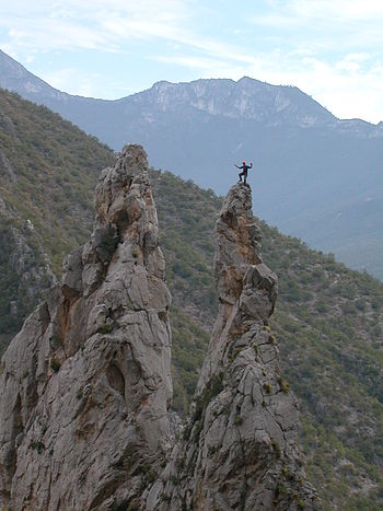
"The Spires" in El Potrero Chico climbing area (Wikipedia photo)

“The Spires” in El Potrero Chico climbing area (Wikipedia photo)

The El Sendero Luminoso rockface is in an area known as El Potrero Chico, a short distance from Monterrey, near the town of Hidalgo.

The Wikipedia entry for El Potrero Chico describes it as having “a large range of different climbs, most of them in the 5.8 to 5.13 grade. The type of climbing can range from steep overhanging face to easy slab. The rock is usually quite sharp. The climbs are mostly situated in a canyon at the entrance of the park, while the interior offers undeveloped mountain terrain with many mountain biking routes, ranging from very easy to expert options.”

According to Wikipedia, El Potrero is “considered one of the top 10 locations to sport climb in the world. In addition to well over 500 routes, the area boasts the second longest sport route in North America, Timewave Zero, with 23 pitches and over 2,000 feet (610 m).”

Related posts:

Mexcaltitán, a magical island town in Nayarit

 Other  Comments Off on Mexcaltitán, a magical island town in Nayarit
Nov 102014
 

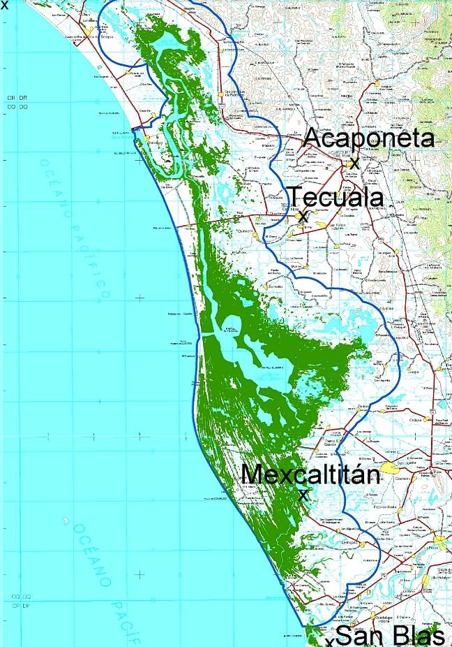
A short distance north of San Blas, in Nayarit, is a small island called Mexcaltitán. With barely four thousand inhabitants, it would scarcely be expected to have any real link to Mexico City, the world’s greatest metropolis of some twenty million people. But it does, and the link is to be found in the amazing story of the founding in 1325 of the Aztec capital Tenochtitlan, the city which was later conquered and sacked by the Spanish and rebuilt as Mexico City.
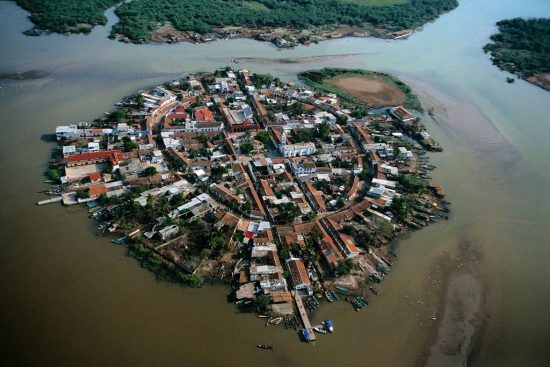
The island and village of Mexcaltián, Nayarit

The island and village of Mexcaltián, Nayarit

Historians have long wondered about the origins of the Mexica people, or Aztecs as they later became known. There is virtually no evidence of them before they founded the highly organized city of Tenochtitlan in 1325. Clearly such a civilization cannot just have sprung up overnight. So, where did they come from? Mexica (Aztec) legend tells of a long pilgrimage, lasting hundreds of years, from Aztlán, the cradle of their civilization, a pilgrimage during which they looked for a sign to tell them where to found their new capital and ceremonial center. The sign they were looking for was an eagle, perched on a cactus. Today, this unlikely combination, with the eagle now devouring a serpent, is a national symbol and appears on the national flag.
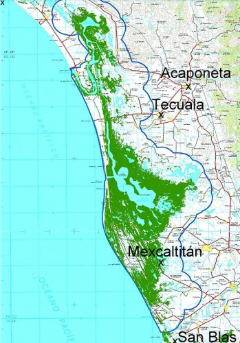
Map showing location of Marismas Nacionales

Map showing location of Marismas Nacionales

In recent years more and more evidence suggests that Aztlán may be far from mythical and that Mexcaltitán, the island in Nayarit, could be its original site. Ancient codices (pre-Columbian hand-painted manuscripts) prove that the Aztecs’ search for a new place to live was ordained by Huitzilopochtli, their chief god. It began in about AD1111 when they departed from an island in the middle of a lake. Their two hundred year journey took them through present-day Nayarit, Durango, Zacatecas, Jalisco, Michoacán, Guanajuato and Querétaro, and they may well have rested awhile on encountering familiar-looking islands in the middle of lakes such as Chapala and Pátzcuaro.

One of Huitzilopochtli’s alternative names was Mexitli and the current spelling of Mexcaltitán could be interpreted as “Home of Mexitli”, or thus, “Home of Huitzilopochtli”. In fairness, it should be pointed out that if the original spelling was Metzcaltitán (and “tz” often became transliterated to “x” down the centuries), then the meaning would become “Place next to the home of the Moon”.

Whatever the etymology of the name, early codices such as the Boturini Codex show the early Aztecs setting out from an Aztlán surrounded by water, in small canoes. The Mendoza Codex, depicting life in Tenochtitlan, has illustrations of similar canoes and, in both codices, the canoes and method of propulsion by punting show remarkable similarity to the present-day canoes of Mexcaltitán. Visitors to the island still have to undertake a canoe or panga ride to reach the village and it is an intriguing thought that the Mexica/Aztecs were doing exactly the same over eight hundred and fifty years ago.

Further evidence comes from an old map of New Spain. Drawn by Ortelius in 1579, it shows Aztlán to be exactly where Mexcaltitán is to be found today, though perhaps at the time this was largely conjecture.

The street plan of Mexcaltitán, best appreciated from the air, is equally fascinating. Two parallel streets cross the oval-shaped island from north to south, and two from east to west, with the modern plaza in the middle, where they intersect. The only other street runs around the island in a circle, parallel to and not far from the water’s edge. This street may have been the coastline of the island years ago and may even have been fortified against the invading waters of the rising lake each rainy season. Today, as then, for several months in summer the streets become canals, bounded by the high sidewalks each side and Mexcaltitán becomes Mexico’s mini-Venice as all travel has to be by canoe.

This street pattern has cosmic significance. It divides the village into four quarters or sectors each representing a cardinal point, reflecting the Mexica conception of the world. The center can be identified with the Sun, the giver of all life. The Spanish, as was their custom, built their church there, and today the central plaza with its bandstand is the obvious focal point of the community. Small shops, a billiards hall, a modern, well-laid out museum, and an administrative office complete the central area of the village.
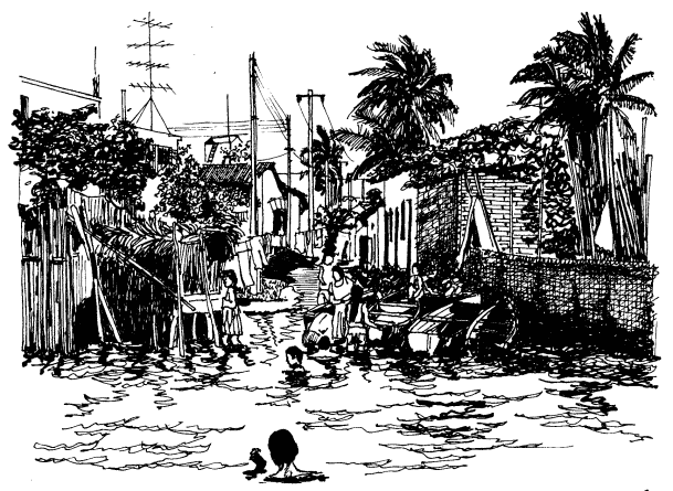
 

Mexcaltitán pen and ink drawing by Michael Eager

Mexcaltitán (pen and ink drawing by Michael Eager from chapter 26 of Western Mexico, A Traveler’s Treasury). All rights reserved.

Low houses, of adobe, brick and cement, line the dirt streets and extend right down to the water’s edge, in some cases even over the water’s edge into the surrounding lake, on stilts. Land on the island is at a premium and, with an ever-growing population, saturation point is very near.

A century ago, the locals turned on some foreigners who came to hunt female egrets, valued for their plumes back in the days when feathers adorned fashionable ladies’ hats. Today, provided only photos are taken, all visitors are welcomed! The villagers celebrate one of the most unusual and distinctive fiestas in all of Latin America. On 29 June each year they organize a regatta which consists of a single race between just two canoes, though naturally hundreds of other pangas are filled with spectators. One of the competing canoes carries the statue of Saint Peter from the local church, the other carries Saint Paul.

Elaborate preparations precede the race. The village streets are festooned with paper streamers and the two canoes are lavishly decorated by rival families carrying on an age-old tradition. The Ortíz family is responsible for St. Peter’s canoe, the Galindo family for St. Paul’s. The statues of the two saints are taken from the church and carried in procession to the boats. A pair of punters has previously been chosen from among the young men of the village for each boat. The punters have been suitably fortified for the contest with local delicacies such as steamed fish, shrimp empanadas, and the local specialty, tlaxtihuile, a kind of shrimp broth. Each boat, in addition to the punters and the statue of the saint, carries a priest to ensure fair play. The race starts from the middle of the eight kilometer long lake after a short religious service in which the priests bless the lake and pray for abundant shrimp and fish during the coming year. Then surrounding spectator canoes, some with musical bands, and others shooting off fireworks, move aside and the race begins.

Nowadays, St. Peter and St. Paul take it in turns to win, most considerate in view of the violence which years ago marred the post-race celebrations when the race was fought competitively. The ceremonial regatta safely over, land based festivities continue well into the night.

A canoe ride around the island takes about 30 minutes and provides numerous photo opportunities as well as many surprises including a close-up view of the island’s only soccer pitch—in the middle of the lake, under half a meter of water. The local children are, perhaps not surprisingly, expert “water soccer” players, a fun sport to watch.

Even if you’re not interested in the island’s past and are unable to see it on fiesta day, your trip to Mexcaltitán will be memorable. This extraordinary island and its village have to be seen to be believed.

The island is reached from the Tepic-Mazatlán highway, Highway 15. There are two alternatives. The northern route is signposted 73 kilometers north of Tepic; it starts with 26 kilometers of paved road crossing swampy paddy fields, followed by 16 kilometers of well-graded dirt road to Ticha, the landing-stage for boats to the island. The drive is through a naturalist’s paradise, teeming with wildlife. The equally scenic southern route begins 57 kilometers from Tepic and is via Santiago Ixcuintla (basic hotels only; don’t miss visiting the center for Huichol Indian culture and crafts) and Sentispac. It leads to the La Batanga landing-stage, and is fully paved.

Note:

This post is based on chapter 26 of my “Western Mexico: A Traveler’s Treasury” (link is to Amazon’s “Look Inside” feature), also available as a Kindle edition or Kobo ebook.

Related posts:
The 2014 Tecate SCORE Baja 1000 off-road race

 Other  Comments Off on The 2014 Tecate SCORE Baja 1000 off-road race
Nov 082014
 

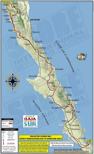
Entrants in the 2014 Tecate SCORE Baja 1000 off-road race have to complete a grueling off-road route that runs almost the entire length of the Baja California Peninsula. The race starts in Ensenada, Baja California, and ends in La Paz, Baja California Sur (see map). The approximate point-to-point distance is 1820 kilometers (1,130 miles). The 47th Tecate SCORE Baja 1000 race is being held this year from 12-16 November.

Route of Score 1000 Baja off-road race

Route of Score 1000 Baja off-road race

The race gives us a good excuse to offer this brief introduction to the geography of the very long, narrow Baja California Peninsula, which stretches for about 1150 km (700 mi).

In the north, it is composed of mostly granite, while the south is mostly marine sediments and lava.

To the east of the peninsula, the Sea of Cortés (Gulf of California) occupies a trough resulting from a series of faults which are linked to the famous San Andreas Fault system in California. Prior to the opening up of the Gulf of California, the peninsula was attached to the mainland. There are several volcanic islands in the Gulf.

The backbone of the peninsula is a crystalline mountain system with many peaks exceeding 1500 m (5000 ft) and some reaching as high as 3000 m (10,000 ft). The mountains have longer, gentler western slopes and steeper more rugged eastern slopes. Thus, as viewed from the Gulf of California, the Baja Mountains and the Western Sierra Madre look steep, foreboding and very rugged, while from the other side they look more subdued.

Climatically, almost the entire peninsula is extremely arid and forms the western part of the Sonoran Desert. It receives only limited and infrequent rainfall. However, the southern part of the peninsula does experience the occasional hurricane (such as Hurricane Odile earlier this year) which brings powerful winds and torrential downpours.

Population is distributed very unevenly on the Baja California Peninsula. The heaviest concentration of people is found in the extreme north, close to the U.S. border, a region which includes the cities of Tijuana, Mexicali and Ensenada. There are very low densities of population in most of the middle section of the peninsula, where the most important settlements include Guerrero Negro, Santa Rosalía,Ciudad Insurgentes and Ciudad Constitución.

The southern portion of the peninsula has attracted more settlement and this area, which includes San José del Cabo, Cabo San Lucas, La Paz and Todos Santos, is one of Mexico’s premier tourism regions.

Want to read more?

The regional geography of music in Mexico

 Other  Comments Off on The regional geography of music in Mexico
Nov 062014
 

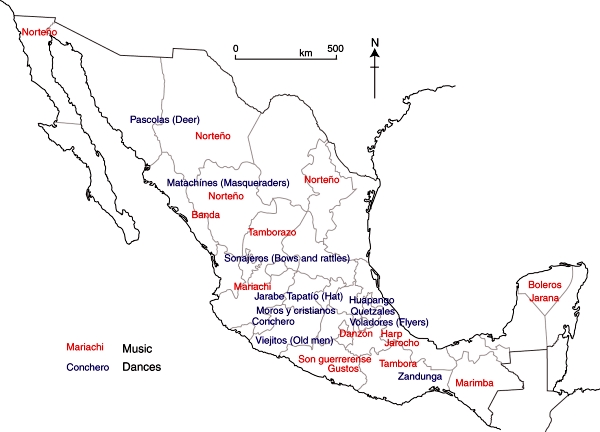
Here are brief descriptions of some of the most commonly heard forms of regional music within Mexico. What you hear depends on where you travel!

Mariachi

For many decades, mariachi has been widely considered to be the quintessential Mexican folk-music genre, and has become an important symbol of Mexican music and culture.

A mariachi band is a term used to describe an ensemble band of five or more musicians that wear the traditional costume of a charro or Mexican cowboy. The costume consists of a waist-length jacket, tightly fitted pants and boots and a large sombrero. The jacket, pants and sombrero are elaborately decorated with colorful metal ornaments and intricate embroidered designs.

The unique sound of mariachi music is created by combining trumpets, violins, and guitars with two traditional Mexican instruments, the vihuela and the guitarrón. The music is characterized by loud, hard driving rhythms, spirited melodies and humorous lyrics. Shouts and cries (gritos) are periodically given while a song is being sung, giving the music an additional lively character.

Music and dance in Mexico.

Music and dance in Mexico. Fig 13.3 of Geo-Mexico, the geography and dynamics of modern Mexico. All rights reserved.

Ranchera

Another very popular Mexican music form is the ranchera (ranch song), which originated during the time of the Mexican Revolution. It is basically cowboy music, and the singers dress in the traditional style of the Mexican horseman with tight breeches, jacket, boots, gun holsters and a large sombrero.

The lyrics of ranchera songs typically deal with rural life, unrequited love, or about the struggles of ordinary people living in the country. The songs are sometimes joyous and sometimes nostalgic or tragic, and are often sung in a very dramatic and passionate manner, with the singer crying out “Ay, ay, ay, ay, ay!” at various points.

Norteña

Another popular music genre, particularly in northern Mexico, is the norteña. This form of music has its origins in the ballads that were traditionally sung by people living along the USA-Mexico border. This music style is typically a hybrid of many other musical forms, including the waltz, polka, and country music.

Norteña is high energy music, driven by the accordion and the booming bass sound of the bajo sexto, a large 12-string guitar. The lyrics of norteña songs typically deal with stories of life along the border, illegal immigrants, outlaws and desperados, drug dealers (narcotraficantes), corrupt public officials, rejected lovers, etc.

Many norteña bands are quite large, with a full horn section and strings. The genre’s most famous group, Los Tigres del Norte has cultivated a large number of fans both in Mexico and in the USA.

Banda

Banda (Band) refers to the form of music played by large brass ensembles that first appeared in the northern Mexican state of Sinaloa several decades ago. A typical banda ensemble features trumpets, trombones, tubas and percussion instruments, and may include keyboards. String instruments are used sparingly, if at all. Banda sounds somewhat similar to American Big Band music, but with a distinctive Hispanic twist.

Related posts:

What are Mexico’s leading exports?

 Other  Comments Off on What are Mexico’s leading exports?
Nov 032014
 

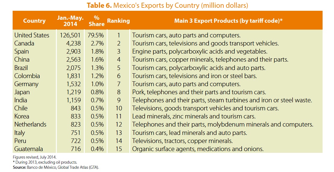
The table shows the destinations of Mexico’s major export flows, excluding petroleum-related exports, for the first five months of 2014. (All data from Pro-Mexico.) It is no surprise that Mexico’s two main export partners are the USA and Canada, its partners in the North American Free Trade Agreement (NAFTA), but the other countries in the list are far harder to guess, and even most economists would struggle to get them in the right order!

Mexico's leading exports by country, Jan-May 2014 (Pro-Mexico, 2014)

Mexico’s leading exports by country, Jan-May 2014 (Pro-Mexico, 2014)

Spain, on account of its colonial dominance and shared language, has long been a major destination for Mexican exports, whereas China (#4 on the list) is a recent entry, and one that has risen rapidly in importance for a wide variety of products. The other Asian countries on the list of the top 15 export destinations are Japan, India and South Korea.

All the remaining top 15 destinations for Mexican exports are in either Europe or Latin America.

In terms of the items exported, vehicles of various categories clearly lead the way by a wide margin, while various electrical or electronic items (telephones, televisions, computers) are also important. It appears that Japanese consumers must like Mexican pork, since that is Mexico’s leading export to Japan.

And who would have guessed that Mexico also exports significant quantities of iron and steel waste to India, or lead minerals to Italy?

For more details of Mexican exports, and a link to an interactive webpage about Mexico’s foreign trade since 1964, see our previous post Trends in Mexico’s foreign trade and Economic Complexity.

Related posts:

Oct 272014
 

The following account of Mexico’s traditional (folkloric) and introduced musical instruments consists of extracts from an article by Andrea Teter. [1]

Pre-Columbian instruments

Archaeologists have noted the existence of more than 1,400 musical instruments used in pre-Columbian Mexico and Central America. These were used primarily for religious, and healing rituals and for ceremonies, but also for war, dances, fiestas and entertainment. Some of these instruments, primarily the huehuetl, and teponaztli, both percussion, and the tlapitzalli, a four-hole flute, were considered divine or endowed with supernatural powers, say Mexican archeologists, and were worshiped as idols.

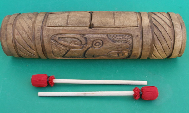
Teponaztli

Teponaztli

The Mexica (Aztecs) used flutes and trumpets made of clay, bamboo and metal. Drums, including the ayotl, made of tortoise shells, and other percussion instruments were used extensively. The huehuetl was the principal drum used by the Mexica and was made from animal skin stretched over a hollowed-out tree trunk. The teponaztli was made from hollowed-out trees or dried gourds, and sometimes gold and silver, with grooves or tongues cut into the top. Rich and varied tones are produced when played with small mallets. Pre-Columbian musicians also used cymbals, maracas, bells and even stones to produce their music.

The Youtube clip below is one interpretation of what some of Mexico’s indigenous musical instruments may have sounded like when played:

Europeans arrive

With the invasion of the Spanish, these musical instruments were immediately used to help convert the indigenous population to Christianity, while the Conquistadors began introducing European musical methods and instruments. A Franciscan missionary, Pedro de Gante, established the first music school in Mexico in 1523 and trained students in the construction and playing of European instruments.

Little by little, all of the European instruments were introduced to Latin America, starting in the 16th century with organs, guitars, harps and flutes, and later followed by the violins, trumpets, mandolins and accordions. Especially important and influential were guitars, which rose to prominence in the seventeenth century, as an easier-to-play alternative to the lute.

Six-string guitars, viheulas, became extremely popular in Mexico with other instruments of the same family also put into general use: five-string charangos, tiples, or treble guitars, and a large 12-string guitar similar to a bass, the bajo sexto.

Another string instrument that became popular in Mexico was the mandolin. The mandolin, which comes from Southern Italy, is the most recent development of the lute family. It was popularized in Mozart’s “Don Giovanni” and Verdi’s “Othello”.

The salterio, originally from Egypt, is a stringed instrument a little larger than a briefcase with a sound resembling a harpsichord and a playing method resembling a steel guitar or autoharp. The musician plucks the 97 strings while it rests on his knees; the sound is unique and quite beautiful.

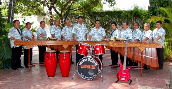
Once the Spanish began importing slaves from Africa, these blacks began constructing marimbas, which imitated the African xylophone. As early as 1545, a Spanish scribe in the state of Chiapas wrote of an instrument of eight wood bars played with heavy sticks by the local natives at tribal ceremonies. The modern sophisticated Mexican marimbas was developed by Chiapas musician Corazon Borraz, who in 1896 brilliantly added a second row of half-tone bars to the common single row (like a piano’s black keys) adding to the musical scope of the original instrument, allowing it to play more complex music.

marimba

A marimba band: two marimbas plus guitar and drums

Today, a concert marimba can be three meters long, have 70 keys and weigh more than 55 kilos. This grand instrument demands four musicians; the bass man at the wide end with two sticks or baguetas having small rubber balls on the striking tips. This end has long resonance boxes hanging below the sound keys. Then the harmonics man with one or two sticks in each hand above shorter resonance boxes. Then comes the melody maker and leader, wielding two sticks per hand; then the narrow end controlled by the treble master, a stick in each hand producing counterpoint to the melody. Talk about a compact orchestra!

The variety of instruments Mexican musicians and composers have access to has resulted in a distinctive music for this country. At least one Mexican composer, Carlos Chavez, has gained international fame with his integration of Mexican pre-Hispanic instruments in his works such as “Sinfonia India,” “Xochipilli” and “Macuilxochitl.”

Some Mexican composers have been even more innovative. For example, Julián Carrillo (nominated for the Nobel Prize in Physics in 1950), one of Mexico’s top violinists, invented a microtonal music system known as Sonido 13. The system became sufficiently famous that Carrillo’s birthplace in the state of San Luis Potosí felt obliged to rename itself Ahualulco del Sonido 13: an interesting place to visit for any geographers interested in microtonal music! Ahualulco del Sonido 13 is located 39 kilometers northwest of the city of San Luis Potosí. Leaving that city, first follow federal highway 49 towards Zacatecas and then turn north on the road signed Charcas.

Want to read more?

Note:

[1] The bibliographic details for Andrea Teter’s article are currently unknown. Please contact us if you are able to supply any further information about these extracts, so that we can update to include the full reference.

Related posts:

Oct 202014
 

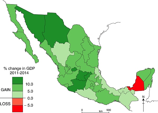
Which of Mexico’s states have the fastest growing economies? The map below, based on INEGI data, shows each state’s percentage change in GDP for the three year period from 31 March 2011 to 31 March 2014.

Change in GDP by state, 2011-2014. Data: INEGI. Credit: Geo-Mexico

Change in GDP by state, 2011-2014. Data: INEGI. Credit: Geo-Mexico

Only one state – Campeche – registered “negative growth” over the period. In Campeche, production from the oil fields that have long been a mainstay of the local economy has been gradually declining.

Besides Campeche, six states grew far slower than the average for Mexico: Durango, Veracruz, Tabasco, Chiapas and Guerrero. Not entirely coincidentally, several of these states are among the poorest in the nation, so their failure to grow as quickly as the average leaves them further behind, increasing the economic inequalities that plague Mexico’s development.

At the other end of the spectrum, the economic growth of six states – Sonora, Chihuahua, Aguascalientes, Guanajuato, Michoacán and Querétaro – easily outpaced the average for the country. Sonora, Chihuahua, Guanjuato, Querétaro, and to a lesser extent Aguascalientes, all benefited from foreign direct investments and new industries, such as those involved in  the vehicle manufacturing and aeronautical sectors.

The case of Michoacán is something of an anomaly, since that state’s economy is still heavily dependent on primary products such as avocados and iron ore. The positive growth in that state may prove to be mainly due to its negative growth in the preceding three years (2008-2011), which meant that it started the three year period shown on the map at an unusually low level. Perhaps more importantly, given the state’s recent political upheavals and gang-related violence, it is highly unlikely that Michoacán will continue to grow anywhere as quickly over the next three years.

Related posts:

Are Monarch Butterflies in danger of extinction?

 Other  Comments Off on Are Monarch Butterflies in danger of extinction?
Oct 182014
 

As a species, monarchs are native to North America, but subsequently island-hopped their way around the world—across the Pacific to Hawaii, Tonga, Samoa, Australia and New Zealand, and across the Atlantic to Europe. In parts of Mexico, particularly in the area around Lake Chapala, there is a healthy population of non-migrating monarch butterflies; these butterflies can count on year-round access to milkweed plants on which to lay their eggs. As a result, it is reasonable to conclude that the species itself is in no danger of extinction.

However, what may be “endangered” is the annual migration of Monarch Butterflies to and from Mexico. This annual migration is categorized as an “endangered phenomenon” by the International Union for Conservation of Nature. Threats to the migration come from climatic change and extremes, as well as from the impacts of human activity. In some years, unusually cold snaps and hailstorms have caused the premature death of millions of butterflies, though, as yet, this has had little if any discernible effect on total monarch numbers. Human activity has greatly reduced the area of the monarchs’ natural overwintering habitats, in both California, for real estate developments, and in Michoacán, due to forest clearance for timber and agriculture. Farming activities in the US have also resulted in the loss of milkweed along the Monarchs’ migratory pathways. This loss may have far more serious consequences on the long-term viability of the annual migration. Without milkweed, the female Monarchs are unable to lay their eggs on a suitable host plant, and the Monarch caterpillars will never acquire their chemical defenses against predation.

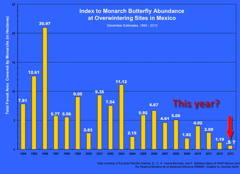
The numbers of Monarchs overwintering in Mexico have varied greatly from one year to the next. The graph below, reproduced widely in the press, has been used as evidence that the numbers of migrating Monarchs are in sharp decline. A note of caution is needed, though, since the estimates of numbers used for the graph are based on the area of trees occupied by the butterflies, and not on a direct count (which is clearly impractical!)

Monarch-Trends-1994-2013

The challenge for researchers is to be certain that the density and architecture of trees is similar from one year to the next. If the trees are less densely grouped, for example, one year than the next, in the particular areas occupied by the butterflies, then the area the butterflies need will be correspondingly larger. The lower area in recent years could be at least partially explained by a higher tree density in the overwintering areas, allowing the same number of butterflies to co-exist in closer proximity to each other.

This is not to say that there is not cause for concern. According to the National University (UNAM)’s Environmental Geography Research Center, at current rates of deforestation, the area of overwintering sites for the Monarch butterflies could be reduced by 75% in the next 18 years, leaving just 12,000 ha of suitable habitat. The protected area, established in 2000, covers 560 square kilometers (56,000 ha. or 216 sq. mi) but includes land cleared for pasture, settlement and cultivation. Researcher José López García claims the reserve is losing 3% of its forest each year. He blames clearance and changes of land use more than illegal logging. The rate of forest clearance has been exacerbated by a rapid rise in the population of the El Rosario ejido. El Rosario is the gateway to the most-visited part of the reserve, attracting thousands of tourists annually. The ejido’s population rose by an average of 5.65%/year between 2005 and 2010.

What is Mexico doing about this?

The Mexican conservation strategies for the butterflies are designed to protect their overwintering habitat and provide alternative sources of revenue and employment for local campesinos who depend on the land and forest for their livelihood. After some doubtful years in the early 1980s, there is now a system of formally protected monarch butterfly reserves, and concerted conservation efforts to prevent further destruction of the monarchs’ unique overwintering habitat.

The modest entrance fees to Monarch Butterfly reserves help fund development projects in the local communities. There is a strict code of conduct for tourists to prevent noise, littering and straying from the well-marked paths.

While the new rules have undoubtedly had some success, it is still preferable to visit, if at all possible, during the week and not at the weekend when the reserves are at their crazily busiest.

On a quiet day,pausing to catch your breath in the peace of the forest as you climb the trail, you will then be just as surprised as I first was when you realize that the gentle swishing sound you can hear around you is not the sound of the wind blowing through the tree limbs but the sound caused by millions of tiny wings beating as the butterflies flutter about in the sky.

Related posts:

The Ghost Train (El Tren Fantasma): a case study of the geography of sound in Mexico

 Books and resources, Other  Comments Off on The Ghost Train (El Tren Fantasma): a case study of the geography of sound in Mexico
Oct 162014
 

Geography is not only about things that can be seen, touched and measured. Many branches of geography consider how people think, how communities make decisions and how nations interact.

At a local scale, one of the characteristics that is often overlooked is sound. We often ignore the soundscapes of places, either because we are “too busy” to listen and take in the local sounds, or because we are “too busy” tuning any distinctive local sounds out while using our cell phones or listening to favorite music.

Soundscapes vary greatly from rural areas to urban areas, and from one region to another; Mexico’s urban soundscapes are among the most distinctive on the planet.

In previous posts, we listened to The distinctive sounds of Mexico’s towns and cities; covered our ears as we analysed Noise pollution in Mexico; and also described the amazing Whistled language of the Chinantec people in Oaxaca.

In this post, we take a look at Chris Watson’s intriguing 2011 album “El Tren Fantasma”:

U.K.-based Chris Watson is a preeminent freelance recordist of wildlife and natural phenomena, whose work has been featured in many BBC programs including David Attenborough’s series, The Life Of Birds. As Watson has remarked, sound recording allows you to put a microphone where you can’t put your ears, to enable you to listen to sounds such as the groaning ice of a moving glacier. His work for the BBC was audio vérité but more recently, including in El Tren Fantasma, Watson has experimented with post production techniques to meld field recordings into a narrative.

The result is strangely compelling, dramatic and in some respects, awesome!

The soundscapes of El Tren Fantasma (the title is identical to that of a 1927 Mexican movie) offer a trip from the Pacific Coast to the Gulf Coast of Mexico condensed into little more than an hour.

The first six tracks cover the section of railway best known as the Copper Canyon line, one of the few remaining routes in Mexico with regular passenger service.

El Tren Fantasma has 10 tracks (pun intended):

  1. La Anunciante
  2. Los Mochis
  3. Sierra Tarahumara
  4. El Divisadero
  5. Crucero La Joya
  6. Chihuahua
  7. Aguascalientes
  8. Mexico D.F.
  9. El Tajin; El dia y La noche
  10. Veracruz

If you don’t have time to listen to all 10 tracks, the most interesting, from a geographical point of view, are probably the following:

The trip was nicknamed the ghost train by Watson because there are no longer any passenger trains connecting the two coasts. Several years ago, Watson was the sound recordist for a film crew making a program in the BBC TV series Great Railway Journeys. Even then, part of the line was freight only, but in earlier times, there had been regular scheduled passenger trains across the country.

The promotional material asks potential listeners to, “Take the ghost train from Los Mochis to Veracruz and travel cross country, coast to coast, Pacific to Atlantic. Ride the rhythm of the rails on board the Ferrocarriles Nacionales de México (FNM) and the music of a journey that has now passed into history.”

“In this album, the journey of the ‘ghost train’ is recreated, evoking memories of a recent past, capturing the atmosphere, rhythms and sounds of human life, wildlife and the journey itself along the tracks of one of Mexico’s greatest engineering projects.”

Reviews were almost universally positive.

Several reviewers recognized the connection between the soundscapes of El Tren Fantasma and geography, in some cases also attributing reasons for the decline of passenger train services in Mexico. For example Martin Hoyle, writing in The Financial Times, described how “From desert to rainforest, hummingbirds’ wings to the boom of heat rising from the Copper Canyon, it recalls a beloved passenger train system abandoned by privatisation.”

Pete Naughton in The Daily Telegraph wrote that the sound portrait painted by Watson “jostles with human, animal and mechanical life, filling the room with an atmosphere that is more richly evocative of Central America than any TV travel show I’ve seen. Diesel engines thrum, cicadas chirrup and passengers chatter, sing and argue.”

A reviewer in The Milk Factory (UK) drew attention to the “tremor of excitement as the sound of a diesel engine temporarily swallows the clunking noise of metal on metal and the strident hisses as wheels grind again rails and breaks against wheels”, before adding that, “Watson doesn’t aim to recreate the journey in any consistent chronology. Instead, he gives a taste of what this journey actually was by using nature and wildlife sounds to hint at the landscapes passed on the way.”

Spencer Grady, reviewing El Tren Fantasma for BBCi (UK), wrote that: “While Chris Watson’s previous sets – such as 2003’s critically acclaimed Weather Report – have generally concerned themselves with this planet’s myriad beasts and habitats, this narrative inevitably bears an anthropological mark. Indeed, the first voice we hear doesn’t belong to a cuckoo or coyote, but station announcer Ana Gonzalez Bello putting out one “last call for the ghost train”. It’s an unusually contrived opening gambit, from which point the listener is jettisoned into a collision of screeching breaks, rolling stock rattle and hot hydraulic huff. Over half of El Tren Fantasma’s tracks (pun definitely intended) are given over to locomotive sound – gears shifting, hoots, bells and whistles – climaxing with El Divisadero, where Watson manipulates the monolithic machinations into a surging, phantasmal bellow, like a choir of angels struggling to be heard over the rumbling thrum of running gear.”

For an academic geographer’s perspective on El Tren Fantasma, a good place to start (for those with academic library access) is a recent issue of Transactions of the Institute of British Geographers (Vol 39, No 3, 2014). In “El tren fantasma : arcs of sound and the acoustic spaces of landscapes”, George Revill, of the Open University, draws on Chris Watson’s soundwork “El tren fantasma” to consider “how sound participates in the production of the railway corridor as a complex, animate and deeply contoured historically and geographically specific experience of landscape.”

El Tren Fantasma offers an extraordinarily evocative sound summary of a trip across Mexico; what a shame that there are now so few passenger services left on Mexican railways!

Related posts:

Oct 112014
 

Most monarch butterflies never migrate, but one generation of the North American monarch population undertakes an annual, long distance migration, a journey without parallel in the insect world. Every winter, some one hundred million monarch butterflies fly south into Mexico from the U.S. and Canada. They congregate and spend the winter in a dozen localities high in the temperate pine and fir forests of the states of México and Michoacán.

Where do the Monarchs overwinter?

The exact sites where the butterflies overwinter were only found in the mid 1970s after a search of nearly forty years. Scientists are still unable to explain all the details of this enigmatic annual migration, but their unexpectedly sophisticated navigational ability seems to rely on an incredible innate accuracy in pinpointing their position by using their eyes and antennas to measure the angles of the sun’s rays, compensating for time of day, and ensuring they continue to fly in a southerly direction towards the state boundary separating Michoacán from the State of México.

How fast can they fly?

The tagging of butterflies has proven that they make the 2500 kilometer trip each way at an impressive average speed of 20 km/h, with maximum speeds of up to 40 km/h (25 mph). Monarchs don’t fly at night, partly because they need daylight to navigate and partly because they fly best when sunlight has warmed their wings, like miniature solar panels, raising their body temperatures some 10 to 15 degrees Celsius above ambient air temperatures.

The butterflies are energy-efficient flyers, making regular nectar stops along the way to refuel. One third of their dry body weight is energy-giving fat but far from losing weight on their exhausting journey south, they actually appear to gain it! There are still many mysteries about the monarchs but they certainly provide one of the most amazing natural spectacles to be seen anywhere on earth. Millions of orange butterflies, with black and white-spotted wings, whether flying overhead or, as on cooler days, clinging apparently lifeless to the grey-green fir trees in such numbers that the trees appear to be in blossom, are an absolutely unforgettable sight.

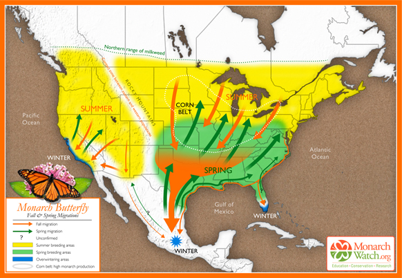
Based on original map design created by Paul Mirocha (paulmirocha.com) for Monarch Watch.

Based on original map design created by Paul Mirocha (paulmirocha.com) for Monarch Watch.

The journey south

In September and October, as temperatures in the U.S. and Canada fall, and food supplies become scarce, the monarchs fly south in small groups. Some of these groups fly only as far as Florida or western California where they spend their winters in milder conditions. But many of the small groups from east of the Continental Divide eventually coalesce and fly much further south, as far as Mexico, arriving en masse in the state of Michoacán towards the end of November.

This migratory group is comprised of as many as 120 million individuals and spends the winter in semi-dormancy, on the pine and oyamel (sacred fir, Abies religiosa) trees found at elevation of about 3050 meters (10,000 feet) along Mexico’s central Volcanic Axis. Until spring comes, in March or April, these butterflies cling to the branches and trunks of the trees, enjoying temperatures between 10 and 16 degrees Celsius, protected from cold northerly winds. Their metabolism slows down in these low temperature, low oxygen conditions and they exhibit movement only on warm, sunny, days.

The generation that flies into Mexico does not mature sexually until the following spring. In February and March, the best months to see them, early spring sunlight begins to penetrate the groves of fir trees, temperatures begin to rise and the forest floor slowly comes alive with new plant growth. The butterflies, having successfully overwintered the worst weather, unfurl their wings and flutter about in search of food and water. As they regain their strength, so they become sexually mature and the mating process starts.

The journey north

After mating, the butterflies begin to leave the reserves, flying back towards the north. Five days later, in northern Mexico and the southern U.S., each female lays two to three hundred eggs on the underside of milkweed leaves. They first check (by smell and touch) that no eggs have already been laid there, and then space their eggs in such a way so as to ensure that each larva that hatches two to three days later will have an adequate supply of food. The larvae grow quickly, changing their skins five times before becoming pupae. After a further two weeks, butterflies emerge, and fly northwards. Each generation of monarchs probably acquires a different chemical “blueprint”, based on the exact species of milkweed it eats, giving it the information it needs to know where to fly. Eventually, by April, the northernmost butterflies reach Canada.

No individual butterfly completes the entire 5000 kilometer round trip. Most of those that fly south die soon after mating in spring (with males often dying in the reserves and never starting their homeward trip), while those who head north cannot hope to survive long into the summer, when normal reproductive cycles, each lasting from four to six weeks, are reestablished.

The last generation of each summer, perhaps prompted by shorter days, soon departs on the next wave of mass migration to Mexico. Those from furthest north will cross the Great Lakes on their return in a single day’s flight, an impressive feat in its own right. They have been spotted flying south at heights up to 1500 meters and exploit thermals to gain height and save energy.

Where to see Monarch Butterflies

Several monarch reserves are open to the public each year. Each has its own distinctive character. Two of the most important reserves are close to the town of Angangueo. Sierra Chincua, north of the town, is the site where the first Canadian-tagged monarch was found in the mid 1970s. This is also where I first saw the butterflies, in 1980, while looking for a potential site for geography fieldwork. It was a serendipitous discovery, and led to me being mistaken for a BBC reporter, but that’s another story!

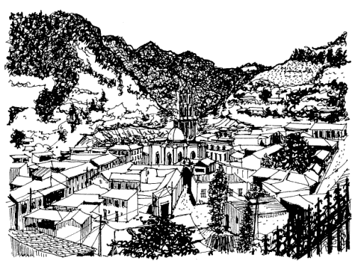
Angangueo. Sketch by Mark Eager; all rights reserved.

Angangueo. Sketch by Mark Eager; all rights reserved.

The most accessible reserve open to the public is El Rosario, south of Angangueo, where there are dozens of souvenir stalls and rustic snack stands—don’t miss sampling the delicious hand-made blue-corn tortillas. The narrow trails in the sanctuary, with information boards at regular intervals, wind steeply several hundred meters uphill, reaching a maximum altitude of 3050 meters. This altitude can cause some shortage of breath and air temperatures are generally low, so be sure to bring a sweater.

El Rosario can be reached from either Angangueo (steeper but more direct approach) or Ocampo. Anyone driving their own vehicle to El Rosario is advised to use the route via San Felipe (on Highway 15) and then Ocampo. From Ocampo any vehicle with adequate ground clearance, including the local taxis, can negotiate the fourteen kilometers to the monarch sanctuary parking lot.

The San Felipe-Ocampo junction on Highway 15 is marked by a line of fruit and soft-drink stalls, many of which in season sell delicious granadas (pomegranates). Also at this junction is an interesting sixteenth century church which, until as recently as 1995, had tombstones in its atrium, unusual in Mexico. Normally, the Spanish buried their dead as far away from the churchyard as possible, presumably to avoid the risk of disease.

Want to read more?

This post is based on chapter 36 of my “Western Mexico: A Traveler’s Treasury” (link is to Amazon’s “Look Inside” feature), also available as either a Kindle edition or Kobo ebook.

Related posts:

Oct 062014
 

According to press reports such as Buscan dar “nueva cara” a Puerto Arista (in El Economista), there are plans afoot to develop nearby mangrove swamps as part of an ecotourism project. Local architects in the coastal town of Puerto Arista in Chiapas are backing the project to build what might best be called Mangrove Riviera.

The state government has released this 4-min video that summarizes the plan, with models and images of the area:

The initial investment required to get Riviera Manglar “Pakal Ahau” under way is around $120 million. The major advantage, from the state’s point of view, is that it would open up a new region of the state for tourism, cashing in on the area’s natural wealth, especially its mangroves. Proponents argue that the town could easily become a major center for ecotourism and that provided that the project incorporates a high degree of sustainability, and prioritizes the cultural identity of each location, it could be a model for similar projects elsewhere.

The six main places involved in Riviera Manglar “Pakal Ahau” are

  • Puerto Chiapas
  • Zacapulco
  • La Encrucijada
  • Costa Azul
  • Chocahuital
  • El Gancho

The project would extend to a subregion including Bahía Paredón, Boca del Cielo, Playa del Sol, Bahía Marías, El Madresal, Mojarras, Laguna La Joya, Cabeza de Toro, Cerro Bernal, Manglares and Villa Tortuguero.

In time, Puerto Arista could become another “tourist gem” in Chiapas and offer an interesting continuation of the long-standing Ruta Maya.

Related posts:

Cananea in Sonora: one of the largest open-pit copper mines in the world

 Other  Comments Off on Cananea in Sonora: one of the largest open-pit copper mines in the world
Oct 022014
 

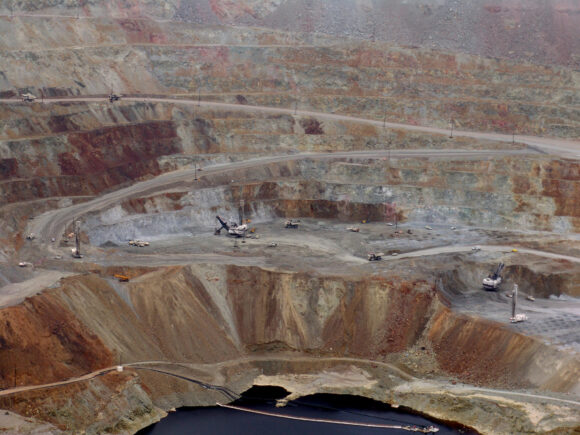
One of the largest open-pit copper mines in the world, the Buenavista del Cobre mine in Cananea produced over 200,000 metric tons of copper in 2012. The mine, opened in 1899, is located approximately 40 kilometers south of the border between Arizona and Sonora, Mexico. The open-pit mine was estimated to contain 26.874 million metric tons of copper reserve as of December 2012.

This mine was the location of a 2014 toxic spill: Toxic spill in Sonora copper mine causes environmental disaster

mina-cananea

Source unknown. Used at http://www.labartolina.com.mx

The ore is refined at an on-site concentrator, which has a milling capacity of 77,000 metric tons/day. The concentrate output is transported to the smelter at La Caridad by rail. Also present are an on-site leaching facility and two solvent extraction and electro winning (SX/EW) plants, with an annual production capacity of 55,000 metric tons of copper cathode.

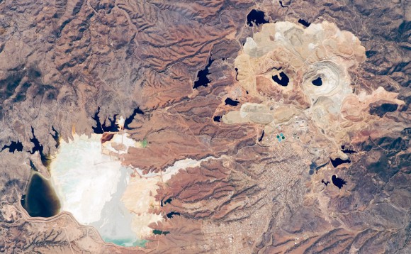
The active, 2-kilometer-diameter Colorada Pit (top right of image below) is recognizable in this astronaut photograph by the concentric steps, or benches, cut around its perimeter (see larger image). These benches allow for access into the pit for extraction of ore and waste materials.

Cananea Mine, Sonora (NASA Earth Observatory, March 2008)

Cananea Copper Mine, Sonora (NASA Earth Observatory, March 2008) Click to enlarge

Water (black) fills the bottom of the pit and several other basins in the surrounding area. The city of Cananea, marked by its street grid, is northeast of the mine workings. A leachate reservoir for removal and evaporation of water pumped from the mine workings is located to the east of the mine (image lower left). The bluish-white color of deposits near the reservoir suggests the high mineral content of the leachate.

sonora-cananea-mina_de_cobre

Source unknown. Credit: https://yoreme.wordpress.com/

Text: NASA’s Earth Observatory and The 10 biggest copper mines in the world

Related posts:

Sep 182014
 

Which countries have the most promising crops of leaders coming up through the ranks today, and where in the world are there more young people likely to develop into business leaders tomorrow? And how can leadership be measured at all? SHL, a U.K.-based talent management consulting firm, released a study in 2012 that aims to provide answers to those questions.

SHL is a giant in the world of employee assessments, with more than 10,000 clients in over 100 countries. It offers services to consultancies like Deloitte and KPMG, multinationals like Unilever and organizations like the United Nations and the European Personnel Selection Office.

Ranking Effective Leaders Today Potential
Leaders of Tomorrow
Ranking change
between leaders for today and leaders for tomorrow
1-25 Country %  Country %   ↑or↓
1 Hong Kong 14% Mexico 54% 21↑
2 Germany 13% Turkey 50% 16↑
3 United Kingdom 10% Egypt 44%  New entry
4 Australia ∞ 10% Switzerland 43% 2↑
5 United States 10% Brazil 42% 19↑
6 Switzerland 10% India 41% New entry
7 Canada 10% Italy 41% 10↑
8 Japan∞ 9% United States 41% 3↓
9 Singapore ∞ 9% Germany 40% 7↓
10 New Zealand ∞ 8% Netherlands 40% New entry
11 Sweden 7% Taiwan 39% 1↑
12 Taiwan ∞ 7% United Arab Emirates 39% 9↑
13 France∞ 7% Denmark 39% 10↑
14 Thailand 7% Sweden 37% 3↓
15 Finland ∞ 7% Portugal 37% New entry
16 Belgium ∞ 7% Russia 37% New entry
17 Spain 6% Spain 37% No change
18 Turkey 6% Ireland 37% New entry
19 Italy 6% Indonesia 37% New entry
20 South Africa ∞ 6% China (Hong Kong) 37% 19↓
21 United Arab Emirates 6% United Kingdom 37% 18↓
22 Mexico 6% Norway 36% 3↑
23 Denmark 5% Poland 35% New entry
24 Brazil 5% Canada 35% 16↓
25 Norway 5% China (Mainland) 34% New entry
∞ Indicates those counties ranked in the top 25 leaders today that fall out of the top 25 for leadership potential tomorrow
“New entry” = countries not ranked in the top 25 today but listed in the top 25 for leadership potential tomorrow
 

This year, executives at SHL decided to mine data from past employee assessments and try to shed some light on the leadership potential in the many countries where it works. The SHL data came from 1.05 million client surveys gathered between 2006 and 2011. It focused on eight different skill areas to measure leadership capability: initiating activity and deciding, supporting and cooperating, interacting with and presenting to others, analyzing and interpreting data, creating and conceptualizing ideas, organizing and executing plans, adapting and coping with others, and finally, performing and achieving.

In September 2012, SHL published a list of the countries it believes have the greatest percentage of effective leaders, and those that it sees as most likely to develop leaders within the next three to five years. The list of current leaders may not be that surprising. The report ranks the country with the most leaders today as Hong Kong (treated as a separate country, though it is a special administrative region of mainland China), followed by Germany, the U.K., Australia, U.S.A., Canada and Switzerland.

The country that emerges as that with the most future leaders is… Mexico. According to SHL, Mexico’s “market is becoming more international and its leaders are strengthening in several different categories.”

This is an interesting analysis, but only time will tell whether or not it holds much validity!

Toxic spill in Sonora copper mine causes environmental disaster

 Other  Comments Off on Toxic spill in Sonora copper mine causes environmental disaster
Sep 112014
 

A toxic spill at a copper mine in the northwestern state of Sonora is the Mexican mining sector’s worst environmental disaster in recent history.

The mine is owned by mining giant Grupo México, Mexico’s largest mining corporation and operated by its Buenavista del Cobre division. Grupo México is the third largest copper producer in the world and has a rail transport division, Ferrocarril Mexicano (Ferromex), that operates Mexico’s largest rail fleet. The Buenavista del Cobre mine, part-way through a $3.4 billion expansion plan, has some of the largest proven copper reserves in the world and is the world’s fourth largest copper mine.

The spill allowed 40,000 cubic meters of toxic copper sulfate acid to enter the Tinajas stream in the town of Cananea on 6 August 2014. Buenavista del Cobre claimed the spill was the result of an unforeseeable heavy rain storm, which triggered a rise in the level of water and copper sulfate in a holding tank being constructed at the copper mine. Grupo México has formed a team of 20 experts from the University of Arizona and Mexican universities to investigate the spill.

However, an initial report by the National Water Commission (Conagua) determined that the spill was caused by a flawed polyethylene pipe at one of the mine’s leachate tanks, together with a faulty valve at another tank. Conagua attributed the environmental disaster to negligence on the part of the company. Mexico’s federal environmental protection agency (Profepa) reported that the contaminants from the spill included copper, arsenic, aluminum, cadmium, chromium, iron, manganese and lead.

Sonora-Copper-Mine-Spill-

Credit: Jesus Ballesteros/Expreso-Cuartoscuro.com

Mexico’s Environment Secretary Juan José Guerra Abud called it the “worst natural disaster provoked by the mining industry in the modern history of Mexico,” and confirmed that the spill contaminated not only the 17.6-kilometer-long (11-mile-long) Tinajas stream, but also the River Bacanuchi (64 kilometers in length), the River Sonora (190 kilometers long) and the El Molinito reservoir which stores 15.4 million cubic meters of water.

The contamination turned the waterways orange (see image) and affected the water supply of 24,000 people in seven communities along the rivers, forcing schools to close for several weeks while environmental authorities clean up the mess. More than 300 wells were shut down. The Sonora state government has been providing millions of liters of water via trucks to residents in the affected area. It has also started a temporary employment program to reactivate the local economy. The mining company has provided 13 million liters of water and $266,000 in immediate assistance to affected communities.

Some 800 mine workers, members of Mexico’s national mining and metallurgical workers union, blockaded the mine entrances in protest at the company’s failure to prevent the spill. Workers have been fighting over contracts since a strike in 2007.

The total clean-up costs are unknown, but likely to run into tens of millions of dollars.

On 18 August, Profepa filed a criminal complaint against Buenavista del Cobre and another Grupo México unit, Minera México, for their alleged roles in the spill. Grupo México could be fined up to 3.3 million dollars if the complaint is upheld.

Sonora State Governor Guillermo Padrés Elías has announced that the seven municipalities affected by the leached copper spill are filing a civil claim for damages.

Eight years ago in the northern state of Coahuila, an explosion in a coal mine belonging to Grupo México left 65 miners trapped underground; only two bodies were ever recovered.

Related posts:

Diana Kennedy and regional cuisines in Mexico

 Other  Comments Off on Diana Kennedy and regional cuisines in Mexico
Aug 302014
 

Diana Kennedy is the world’s foremost authority on regional Mexican cuisines. Born in the UK, she moved to Mexico in 1957 with her husband, Paul Kennedy, a New York Times correspondent. Over the next half a century, Kennedy traveled the length and breadth of Mexico, collecting stories, cooking techniques and recipes, and writing about regional cuisines from all over the country.

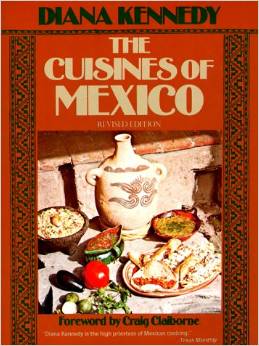
kennedy-cuisines-of-mexicoHer first cookbook The Cuisines of Mexico was published in 1972 and quickly became a classic. She has written several other books about Mexican cuisine, including

Now in her nineties, Kennedy continues to live in an eco-friendly house in s small village near the city of Zitácuaro in the western Mexico state of Michoacán. The Mexican government awarded her the Aztec Eagle, Mexico’s highest award for non-Mexicans, for her truly outstanding contribution to the country.

In this recent BBC radio podcast, Diana Kennedy is interviewed about her lifetime’s work, including the thousands of hours spent driving along dusty dirt tracks in her pick up truck in search of yet another unrecorded gem of Mexican cuisine.

Her travels often took her to indigenous villages, way off the beaten track, where she would study how and what the local people cooked, discovering along the way, all kinds of things never previously written about.

Podcast (mp3 file) of BBC Radio 4 Food Programme about Diana Kennedy :


The initial leads for the next trip often came from the maids of friends in Mexico City, maids who were prepared to share their family recipe secrets with her.

Kennedy documented varieties of corn and beans that are rapidly disappearing, as are the small family farms where they were grown. In most locations, she would start by exploring the local market. Marveling over the incredible fresh produce she encountered wherever she traveled, she recorded every detail; sadly, some of these markets have long since disappeared.

The “Mexican miracle” of the 1960s and 1970s, with its growing economic prosperity brought a tide of imported foods into Mexico. These reached deep into the countryside. In many places, traditional foods were forgotten, replaced by imported items such as wheat bread and pork chops.

Dietary changes have continued to plague Mexico, leading to a dramatic increase in obesity. Note, though, that despite the claims made on this BBC program, Mexico does not yet lead the world in obesity – though it is the fourth most obese country in the world (excluding small island states). Clearly, BBC researchers should read Geo-Mexico more often.

Kennedy’s 1972 book, The Cuisines of Mexico was a ground-breaking look at the regional world of food in Mexico. UNAM, Mexico’s National University, is keeping Kennedy’s work alive by making digital copies of all her notebooks, some of which date back to the 1950s.

For more about Mexican cuisine, visit the amazing award-winning blog Mexico Cooks! and also browse the huge selection of recipes, articles and tips about all aspects of Mexican food and cooking in the “Cuisine” section of MexConnect. ¡Buen provecho!

Related posts:

Aug 232014
 

Mangrove swamps have an undeserved reputation for being impenetrable thickets harboring noxious insects and reptiles. But they also have considerable value, in terms of both ecology and economics, as this case study of the Marismas Nacionales mangroves on the west coast of Mexico will demonstrate.

Map showing location of Marismas Nacionales

Map showing location of Marismas Nacionales

The Teacapán-Agua Brava-Marismas Nacionales Lagoon System extends northwards along Mexico’s Pacific Coast from San Blas in Nayarit to the southern part of Sinaloa. It is one of Mexico’s largest areas of mangroves. The total area of mangroves in the Marismas Nacionales is estimated at 58,100 hectares (224.3 square miles). Four species of mangroves are found here:

  • black mangrove (Avicennia germinans)
  • white mangrove (Laguncularia racemosa)
  • red mangrove (Rhizophora mangle)
  • button mangrove (Conocarpus erectus)

Mangroves in Mexico are estimated to be disappearing at a rate of at least 2% per year, though the available evidence suggests that the Marismas Nacionales mangroves are relatively undisturbed.

A 2012 study, undertaken by a group of Stanford Students for the Ocean Innovations Environmental Defense Fund considered the ecosystem services provided by Mexico’s largest area of mangroves, the Teacapán-Agua Brava-Marismas Nacionales Lagoon System of Nayarit and southern Sinaloa and attempted to calculate the mangroves’ carbon sequestration potential.

The ecosystem services considered included:

  • fisheries for shrimp, mollusk, fish and crustaceans.,
  • aquaculture (primarily shrimp), forestry (charcoal, firewood, wood and roofing materials),
  • agriculture,
  • coastal protection (mangrove roots help bind unstable coasts, preventing erosion and providing a natural barrier against hurricanes),
  • habitat for other species (breeding, shelter and feeding places for fish, crustaceans and birds) and
  • ecotourism (as in Mexcaltitán)
Mezcatitlán

Mezcatitlán, island settlement in Nayarit

The report tries to quantify the value of each of these services. For example, it finds that the total annual revenue brought in by coastal fisheries alone around Marismas Nacionales (including shrimp, catfish, crabs and sharks) almost certainly exceeds $10.8 million.

In terms of carbon storage, the study took into account the carbon sequestered in the form of biomass (as a result of photosynthesis) as well as the carbon exported from the ecosystem via processes such as respiration, sediment burial and mineralization. The total Net Ecosystem Production (NEP) of carbon in the Marismas Nacionales was calculated to be 8 metric tons of carbon/ha/yr or about 470,000 metric tons/yr for the entire area.

Reference:

  • Marismas Nacionales Conservation & Carbon Sequestration Study. Preliminary Report (pdf file)

Related posts:


Mexico’s “little sea cow” on the verge of extinction

 Other  Comments Off on Mexico’s “little sea cow” on the verge of extinction
Aug 202014
 

Wildlife groups from around the world are urging the Mexican government to take urgent action to prevent the extinction of the “little sea cow”, the world’s smallest porpoise, known in Spanish as the vaquita marina, currently the most endangered cetacean in the world.

This particular porpoise is only found in the upper sections of the Sea of Cortés (Gulf of California), and fewer than 100 are thought to exist.

Scientists say that gill-net fishing must be eliminated in the little sea cow’s native habitat for its population to have any hope of recovering to a sustainable level. Mature females will usually only give birth to one calf every two years. Even with a total ban, it would therefore take several years for natural increase to boost the population. In the port of El Golfo de Santa Clara studies have suggested that gillnet fishing is responsible for approximately 39 vaquita deaths a year.

Map of sightings and acoustic detection spots. Adapted from North American Conservation Action Plan for the vaquita

Map of sightings and acoustic detection spots. Adapted from North American Conservation Action Plan for the vaquita

According to Jo Tuckman, writing in The Guardian, environmental groups blame the decline of the popoise population on a “booming illegal trade in the totoaba fish (mistakenly called “toboada” in The Guardian), driven by Chinese demand for its swim bladder, which is believed to have medicinal properties.” Chinese fishermen are alleged to have overfished a similar fish in their own waters, leading to a sharp increase in demand for imports of totoaba. Fishermen in the Sea of Cortés are reported to have been offered more than $4,000 for the single bladder (which weighs 500 grams) of a mature fish.

There have been numerous reported instances of illegal cross-border trade in totoaba bladders, including, Man Admits to Smuggling Swim Bladders of Endangered Fish. The fish has been listed as “endangered” since 1979 under the U.S. Endangered Species Act. Between February and May 2013, border inspectors in Calexico, Arizona, seized the swim bladders of more than 500 endangered Totoaba.

In 2008, Mexico, the USA and Canada launched the North American Conservation Action Plan (NACAP) for the vaquita, under the jurisdiction of the Commission for Environmental Cooperation (CEC), a NAFTA environmental organization. Mexico has also established a program known as PACE-VAQUITA, which compensates fishermen who choose one of three alternatives to commercial fishing: rent-out (payments to avoid fishing in specific areas which are known to have resident vaquitas), switch-out (compensation and inducement to switch technology to vaquita-safe methods), and buy-out (compensation for permanently relinquishing their fishing permits and gear).

Clearly, these efforts have not yet paid off and more stringent controls and enforcement are desperately needed if the vaquita marina is to be brought back from the brink of extinction.

Update (31 December 2014):

“The Mexican federal government has recently proposed a US $37 million compensation plan that would ban gillnet fishing in waters inhabited by the world’s most endangered mammal species.” (Mexico News Daily, 27 Dec 2014)

Want to read more?

Related posts:

Aug 162014
 

Tourism associated with rivers and lakes

So far as tourism is concerned, Lake Chapala is far more important than the other bodies of water within the basin. Only limited recreational activities are practiced in the various man-made reservoirs and in lakes Yuriria and Cuitzeo. Tourism is locally important in Zirahuén the most pristine of the basins lakes, but its small area restricts development prospects. Tourism, including ecotourism, is also locally important in Lake Pátzcuaro, with pronounced seasonal peaks corresponding to school vacations and the annual Night of the Dead. Surprisingly, there are no specialized ecotourism services at Lake Chapala.

Lerma-Chapala Basin

Lerma-Chapala Basin. Cartography: Tony Burton/Geo-Mexico; all rights reserved

The map shows areas of soil degradation in the Lerma-Chapala basin, as well as the locations where agriculture is a major source of water contamination. The environmental impacts of tourism in the basin are concentrated in the major cities such as Guanajuato, San Miguel de Allende and León, as well as in the smaller communities where tourism is of particular importance, such as Chapala and Pátzcuaro.

The lakes in the basin, especially Chapala, have always had more significance than the rivers for recreation and tourism activities. In the nineteenth century, sail canoes plied the waters of Lake Chapala. Fluctuating lake levels since the 1950s have prevented any concerted effort to establish modern water sports (yachting, water-skiing, windsurfing) on the lake, though casual users can be seen sporadically, mainly at weekends and during school holidays. Recreational fishing is virtually non-existent in the basin. Boatmen and fishermen often have conflicting demands.

Potential for ecotourism

Environmental degradation throughout the basin has reduced the number of potential ecotourism locations. The few remaining natural habitats are in urgent need of effective conservation. None of the few small areas of the basin currently protected at a federal level is associated directly with the River Lerma or Lake Chapala. Several tourism hot spots are under extreme pressure, operating at close to carrying capacity (defined as the maximum number of visitors they can handle without adverse environmental impacts). They include the Monarch butterfly reserves, Lake Camécuaro National Park, and the island of Janitzio in Lake Pátzcuaro. Well managed tourism could help finance habitat restoration and protection. Successful planning will require considerable local participation.

Lovers of flora and fauna want to see native and endemic species, rather than imported exotics. Bird-watching is one of the fastest growing recreational activities in the U.S., a huge niche tourism market in a wildlife watching industry worth 10 billion dollars in North America (Stap, 2002). In the basin, bird-watchers have the opportunity to see several endemics, as well as spectacular flocks of the White Pelican (Pelecanus erythrorhynchos), which can be better viewed on the relatively undeveloped southern shore of Lake Chapala than in its breeding grounds far to the north.

The development of horse-back riding, hiking and walking trails holds considerable potential for the future. Niche markets, such as cultural, shopping and eco-tours could all be further developed. Most tourists prefer a mix of experiences; the basin offers numerous, varied tourism possibilities.

Historically, hunting was an important activity in certain areas, particularly in the marshes at the eastern end of Lake Chapala (the ciénega). One ecological issue here, aside from any need to manage wildlife numbers, is the gradual decomposition of the lead-rich cartridges used a century ago. While this needs further study, this is gradually leaching lead into the environment, but is not the only source of the elevated levels of lead that have been reported in fish and lirio samples (Jay & Ford in Hansen & Van Afferden, 127). Careful monitoring is needed to ensure that no health risk is posed to humans.

Tourism exacerbates existing demands for limited supplies of water. This needs to be recognized in tourist-oriented cities such as San Miguel de Allende, Guanajuato and Pátzcuaro. Some recreational and tourism developments are more water demanding than others. Large expanses of grass cause high losses of water through evapo-transpiration especially during the dry season when watering is needed if grass is to be kept green. However, in the rainy season, grass promotes higher infiltration rates, enhancing groundwater recharge. Pressure from public and private gardens for water could be significantly reduced by xeriscaping.

Management is also needed to ensure that chemicals used in gardens, hotel grounds, and hotels do not cause pollution. The misuse of fertilizers and pesticides can have serious deleterious environmental effects. Overfertilization, for example, can increase nitrogen and phosphorus loads on watercourses, promoting eutrophication.

Golf can be one of the least environmentally sound of all recreational activities (Elkington & Hailes 1992). Constructing a golf course may involve habitat destruction and loss of wildlife; its maintenance may require copious quantities of water and agro-chemicals. A single course may use 330,000 cubic meters of water a year, as much as 4,500 people (Walsh, 2004) Aside from the ethical issue of whether water should be allocated to the playgrounds of the rich while the poor go without, golf courses can greatly reduce water consumption with careful design and management. Of Mexico’s 200+ golf courses, at least 23 are located in the basin. Several were built in the past twenty years. Several others are still in the planning stages. More golf courses may attract more retirees and tourists, but decision makers need to consider the possible social and environmental effects of constructing more courses.

References:

  • Hansen, Anne M. & van Afferden, Manfred (ed). The Lerma-Lake Chapala Watershed: Evaluation and Management. New York: Kluwer Academic / Plenum Publishers. 2001.
  • Elkington, John & Julia Hailes. Holidays that don’t cost the earth. The guide to greener holidays. London: Victor Gollancz Ltd. 1992.
  • Stap, Don. “Great Florida Birding Trail” in Audubon Magazine September, 2002.
  • Walsh, J. “War over water”. Golf Course News, October 2004. G.I.Media. 2004

Source:

This post is based on my contribution (on tourism) to the Atlas de la cuenca Lerma-Chapala, construyendo una visión conjunta, published by Semarnat-UNAM-IE, Mexico, in 2006. (The link is to a low-resolution pdf of the entire atlas).

Related posts:

Popocatepetl Volcano continues its very active phase

 Mexico's geography in the Press, Other, Updates to Geo-Mexico  Comments Off on Popocatepetl Volcano continues its very active phase
Aug 092014
 

Popocatepetl Volcano, near Mexico City continues to be very active, with smoke and ashes belching up to 1000 meters above the crater rim. Mexico’s National Disaster Prevention Agency Cenapred, reports that the volcano had 82 “low intensity” exhalations on 7 August 2014, four of which contained “explosive material”.

Popocatapetl, 8 August 2014. Credit: Cenapred.

Popocatapetl, 8 August 2014. Credit: Cenapred.

The agency also reported that many mionr tremors hd been recorded, including one harmonic tremor lasting 56 minutes. Geologists believe that the volcano is currently destroying dome number 50 even as dome number 51 begins to form. Dome #51 is currently about 70 meters in diameter. Renewed explosions, together with some ash fall is predicted for the coming days.

The Volcanic Traffic Light remains at Yellow Phase 2.

For a series of images dated 8 August 2014, see Images of 8 of ago of 2014

Related posts:

Day trips and tourism in the Lerma-Chapala basin

 Other  Comments Off on Day trips and tourism in the Lerma-Chapala basin
Aug 072014
 

An earlier post looked at the significant impacts of the estimated 10,000 to 15,000 residential tourists (non-working, non-Mexicans) living part or full-time in the Lerma-Chapala basin. These residential tourists are concentrated in San Miguel de Allende and in the Chapala-Ajijic area on Lake Chapala:

Day trips and regular tourism are also important activities in the Lerma-Chapala basin. Both day trippers and tourists bring economic, social, cultural and environmental benefits, but may also create adverse impacts. Conflicts between tourism and other activities are increasing as demographic and environmental pressures rise.

Day trips

By definition, day trips last less than 24 hours. Most day trips are to a single destination, usually only a relatively short distance from home. Within the Lerma-Chapala basin, certain day trip flows stand out. The strong flow of day-trippers from Guadalajara to Chapala-Ajijic peaks on Saturdays, Sundays and public holidays. Day trippers account for about two-thirds of the total number of visitors to Chapala-Ajijic. Day trip flows linking San Miguel de Allende, Dolores Hidalgo and Guanajuato, and between Morelia and Pátzcuaro are also important. Elsewhere, the Monarch butterfly reserves have seasonal importance as day trip destinations; for example, El Rosario, the most visited reserve, attracts up to 5,000 visitors a day between early December and late March.

Tourism

Tourism, on the other hand, involves overnight stays. A typical tourist trip lasts between 3 and 8 days. Tourism may involve multiple destinations, further away from home. In Mexico, national tourists are more numerous, but, on average, earn less, spend less, and stay a shorter time, than international tourists.

In the Lerma-Chapala basin, tourism began to flourish at the end of the nineteenth century, alongside improvements in transportation, especially the building of railways. The shores of Lake Chapala were an early magnet for the wealthy. Developers redesigned the unplanned fishing villages, attracting visitors from all over Mexico. Even today, the Chapala landscape reflects the historical and cultural influences which have influenced it.

Other parts of the basin also became important tourist destinations. The colonial cities route, taking in San Miguel de Allende, Guanajuato, Morelia, Pátzcuaro and Querétaro, is a prime example, which has been very successfully marketed.

Quantifying tourism in the basin is difficult. Official tourism statistics are based on surveys, but these data have their limitations. The size of the circles on the map below represents the total number of tourists visiting each location in 2005, according to Tourism Secretariat figures. The yellow segment represents the percentage of tourists that are international. atlas-tourist-numbers-2The map shows that tourism is heavily concentrated at a small number of locations close to the boundary of the basin: Morelia, Toluca, Querétaro, San Miguel de Allende, Guanajuato and Chapala-Ajijic. Foreign tourists are particularly important in Toluca, San Miguel de Allende and Chapala-Ajijic. The precise numbers should be treated with caution. Many tourists visiting San Miguel and Chapala-Ajijic (but not Toluca) do not stay in hotels but in “Bed and Breakfasts” or with friends or relatives.

Tourism planning needs to consider strategies which:

  • preserve existing and potential natural attractions and historic sites.
  • increase the number and variety of locations visited by tourists.
  • reduce the pronounced seasonality of existing tourism.
  • increase the average length of stay and expenditure of tourists.

Source:

This post is based on my contribution (on tourism) to the Atlas de la cuenca Lerma-Chapala, construyendo una visión conjunta, published by Semarnat-UNAM-IE, Mexico, in 2006. (The link is to a low-resolution pdf of the entire atlas).

Related posts:

Quick photo visit to Mexico City

 Other  Comments Off on Quick photo visit to Mexico City
Aug 022014
 

The many stupendous images of Mexico City in “HA!!!, And You Thought We Were Riding Donkeys” on the “Lost in My Little World” blog undoubtedly only portray one side of Mexico City (the nice side), but that does not make them any the less worth viewing.

As the blog’s author puts it, “People are always asking me what living in Mexico City is like. Most people either think its dirt, sombreros and donkeys, or they think that drug dealers and kidnapers are waiting for you to get out of your car to kill you at anytime. None of these speculations are real!! It is one of the greatest cities on earth and this article is here to prove it...”

  • Images of Mexico City

Sadly, the images lack captions, though many of the places are readily identifiable if you have ever visited Mexico’s premier cultural and social center.

Looking for balance? Some of the comments below the images offer links to the many alternative, less attractive sides of the city.

The Magic Town of Tzintzuntzan in Michoacán

 Other  Comments Off on The Magic Town of Tzintzuntzan in Michoacán
Jul 262014
 

Tzintzuntzan, designated a Magic Town in 2012, has two sixteenth century churches, equally ancient olive trees, a craft market specializing in straw goods and ornaments, plus an archaeological site which was the capital of the not inconsiderable Tarascan Empire.

The Tarascan Empire

The Tarascan Empire, contemporaneous with that of the Aztecs, stretched westwards as far as the shores of Lake Chapala, with sporadic contacts into the Sayula lake area, and to the east as far as present-day Zitácuaro. The Tarascans spoke Purépecha, and today the local indigenous people prefer to be called Purépecha. The term “Tarascan” is more properly reserved for their ancestors and their pre-Columbian empire.

“Tzintzuntzan” is an onomatopoeic Purépecha rendering of the sound made by a hummingbird. The ceremonial center was still fully active when the Spanish arrived. Tarascan buildings were constructed mainly of wood. Only the basements were normally built of stone and today, therefore, it is only these basements or yácatas that remain. Some of the cut stones which cover the rubble-filled interiors of the yácatas are ornamented with rock carvings.

The scale of earth-moving involved in constructing the temples is remarkable. The entire 425-meter-long platform is man-made. On it were built five yácatas, on the tops of which would have been wooden and thatch structures serving as shrines. The semi-circular shape of these yácatas suggests that they were built to honor the god of the wind, Ik. The Tarascan ceremonial centre commands a magnificent view over the lake, whose waters would have been lapping at the platform’s base during some rainy seasons. The area behind the yácatas, next to the village soccer pitch blazes with color during the wildflower seasons of late spring and early autumn. The archaeological site has a small, modern museum.

The Tarascans had a mixed economy, collecting fruits and forest products, fishing and undertaking agriculture, complete with terracing and irrigation. Some archaeologists have argued that many of the pre-Columbian peoples, dependent on the natural world for their immediate survival, were very ecologically-conscious. However, in this area, evidence from rates of lake sedimentation now suggests that maybe they weren’t quite so environmentally-aware after all. It seems that erosion rates were already on the rise by the time the Spanish arrived, suggesting that native agriculture was almost certainly not sustainable. Following the introduction of European diseases, the decline in population (and agricultural workforce) prompted a further increase in erosion rates as soil conservation methods could not be maintained. Erosion and sedimentation were exacerbated by the nineteenth and twentieth century deforestation of surrounding hills.

Spanish churches

Tzintzuntzan monastery and church. Artist: Mark Eager. All rights reserved.

Tzintzuntzan monastery and church. Artist: Mark Eager. All rights reserved.

The Spanish destroyed the Tarascan temples, carting off many of the stones to build Catholic churches in their new village. Observant visitors to the beautifully-proportioned patio of the former monastery beside the main church will spot petroglyphs on some of the walls there which betray the stones’ earlier placement in the yácatas. This building, decorated with fine old colored frescoes depicting Franciscan lore, and with parts of its original wooden roof still intact, houses the office of the parish notary and is not always open to the public.

There are other peculiarities here, too, which say much for the realities of sixteenth century Spanish monastic life. When the monastery of Tzintzuntzan was built, two churches were constructed, one for the monks’ private use and the other for the lay Third Order. These two churches, only a few steps apart, are about as different as can be, given that they are of similar age. The monks’ church, beautifully restored following an arson attack, is light and airy; the Third Order church is dark, gloomy and oppressing. Both, in their own way, are awe-inspiring. To one side of the Third Order church is a complete-immersion font, shaded by two tall trees.

Ancient olive trees

In the large atrium in front of the monastery are a sixteenth century cross and the bent and twisted tree trunks of some of the oldest olive trees in Mexico, brought by special request from Spain for the express purpose of providing the monks with one of their accustomed foods. They are thought to be more than four hundred and fifty years old.

Handicraft market

Tzintzuntzan’s handicraft market is a cornucopia of straw work in every conceivable color, design and size, which make ideal Christmas decorations or gifts. Also on sale are elaborately carved wooden beams, and examples of the many different local pottery styles including the Ocumicho devil-figures and strange green pineapples as well as finely detailed, hand-embroidered scenes of village life.

How to get there:

Tzintzuntzan is about twenty minutes drive from Pátzcuaro.

Source:

This post is based on chapter 32 of my “Western Mexico: A Traveler’s Treasury” (link is to Amazon’s “Look Inside” feature), also available as either a Kindle edition or Kobo ebook.

Feliz Día del Geógrafo! Happy Geographers’ Day!

 Other  Comments Off on Feliz Día del Geógrafo! Happy Geographers’ Day!
Jul 232014
 

Today, the 23 July, is “Día del Geógrafo de México” (“Mexican Geographers’ Day”).

Grateful thanks to Annie Hansen for alerting us to the fact that 23 July was first proposed as “Día del Geógrafo de México” (“Mexican Geographers’ Day”) in a short paper published in 1999. Héctor Mendoza Vargas proposed that day because it marked the opening, in 1939, of the first National Congress of Geography ever held in Mexico. His suggestion was the winner in a competition to choose a suitable day on which to celebrate the work of geographers. Ever since then, 23 July has been a special day for all geographers in Mexico.

The first National Congress in 1939 ran from 23 July to 31 July, with sessions taking place in the Palace of Fine Arts (Palacio de Bellas Artes) in downtown Mexico City.

The full text (Spanish) of Mendoza Vargas’ short paper proposing 23 July as “Día del Geógrafo de México” can be seen here. It includes some interesting background history.

Feliz Día del Geógrafo – A Happy Geographers’ Day – to all our readers!

The U.S. Geography Awareness Week

For our north-of-the-border readers, the nearest U.S. equivalent of Día del Geógrafo is the National Geographic Society’s “Geography Awareness Week“, celebrated in the third week of November each year. Geography Awareness Week, signed into law in 1987 by former President Ronald Reagan, seeks “to promote geographic literacy in schools, communities, and organizations, with a focus on the education of children. The need to address geographic literacy came about in 1987 after the NGS conducted a geography survey among adults 18 years and older in the United States. The findings revealed such facts as: the average American adult could identify less than 6 of 10 U.S. states; 3 in 10 adults could not use a map to tell direction or calculate the approximate distance between two points; only 57% of adults could identify England on a map of Europe; and Brazil was the only South American country correctly identified by even half of the respondents.”


Income inequality before and after tax

 Other  Comments Off on Income inequality before and after tax
Jul 212014
 

In several previous posts, we have explained how the GINI index can be used to quantify the degree of income inequality within a population or country. The higher the GINI index, the more inequality there is. National comparisons of inequality are usually based on working out the GINI index for countries using their residents’ gross (pre-tax) incomes. However, it is also possible to calculate the GINI index for net incomes, incomes after taxes have been taken into account.

This enables economists to assess the impact of tax systems on income distribution (and income inequality) in a country.

The graph below (Figure 2 from Brown et al, 2013) shows pre- and post-tax income GINI coefficients for a selection of countries, including the larger economies in Latin America.

gini-pre-post-taxesIn the European countries, such as Belgium and Sweden, on this chart, the GINI coefficient after tax (dark bars) is much lower than the GINI coefficient before tax (light-colored bars). This means that the taxation system has led to less income inequality than existed prior to taxation. In general terms, this means that the tax system is (overall) a progressive one [i.e. one where taxes take an increasing proportion of income as income rises].

In Latin American economies, a different picture emerges. With the exceptions of Brazil and Costa Rica, the GINI coefficients after taxes are taken into account are actually higher than the GINI coefficients before tax, meaning that income inequalities have become greater as a result of the tax system. In general terms, these tax systems are regressive [where taxes take a decreasing proportion of income as income rises].

In Brazil and Costa Rica, the levels of income inequality remain unchanged after taxation is taken into account.

Clearly, if reducing income inequality is a priority for Latin America, then something has to change. Whether a nation prefers a tax system that is regressive or progressive is a question of political beliefs and policy, as well as a question of economics.

It should be noted that the chart is based on calculations using data from 2012 or earlier. It will be interesting to see how Mexico’s recent major fiscal reforms impact its GINI coefficient in the coming years. Will the recent reforms lead to a more equitable situation and reduce the GINI coefficient, or will they foment greater inequality of income, making the rich richer and the poor poorer?

Note:

The exact methodology used to derive the post-tax GINI coefficient is not clear in the original article. In particular, it is unclear whether or not the after-tax income in the chart includes the large number of Mexican workers in the informal sector who generally do not pay any income or payroll tax.

Source of image:

“Towards financial geographies of the unbanked: international financial markets, ‘bancarization’ and access to financial services in Latin America” by Ed Brown, Francisco Castañeda, Jonathon Cloke and Peter Taylor, in The Geographical Journal, vol 179-3, September 2013, 198-210.

Related posts: