auto industry | Geo-Mexico, the geography of Mexico

Nov 072016
 

In a previous post – Mexico’s shoe (footwear) manufacturing industry: regional clustering – we looked at the concentration of the shoe-manufacturing industry in three major areas: León (Guanajuato), Guadalajara (Jalisco) and in/around Mexico City. We have also taken a look at Mexico’s international trade in shoes – Mexico’s footwear industry: imports and exports. We now turn our attention to the distribution of shoe retailers within a large Mexican city.

Shoes in Mexico

The retailing of shoes within cities often exhibits distinctive spatial patterns. Many older and larger Mexican cities tend to have all the retailers for a particular item (furniture, electronics, autoparts, etc) concentrated in a very small area. For example, dozens of retail outlets for electronics are located within a few blocks of Mexico City’s main square or zócalo. Electronics stores are in very close proximity to one other, and occupy both sides of the street for several blocks, leaving little or no room for any other retailers.

Another example of retail specialization is Corregidora street, which has several blocks dedicated to the sale of pots and pans, kitchen utensils and table settings.

Elsewhere in Mexico City’s downtown area:

… turn right and continue down Chile street to the intersection with Tacuba street. One of the most fascinating aspects of commercial life in the downtown area of Mexico City is that each area is specialized in some trade or retail activity. Such trading ghettos were also a feature in Tenochtitlán and the practice still exists today. Where you are now walking is the barrio of bridal shops. The greatest concentration of these shops is north of the Heras y Soto House…” (Candace Siegle, Walking through History, a series of walks through Mexico City’s historic center, 1989)

Returning to the subject of shoes, without which no bridal outfit is complete, shoe retailing is also often heavily concentrated in certain sections of Mexico’s larger cities. Perhaps the most extreme example is in Guadalajara, where shoe retailing is concentrated in two main zones. One of these zones is within the central business district, and is comprised of both regular storefronts and a market. The other area is several kilometers west of the center, around Galería del Calzado, a shopping plaza of more than 60 stores entirely dedicated to shoes. The Galería, located where Yaquis meets Avenida México, has a total floor space in excess of 8,600 square meters (92,500 square ft). The shops in Galería del Calzado stock every major brand and type of shoe, and eagerly compete for your pesos.

From a consumer’s perspective, this is all highly convenient and allows for easy comparison shopping. However, I have never been convinced of the advantages of such concentration from the point of view of the retail store owners, unless perhaps they get their stock from a relatively limited number of (shared) shoe distributors?

Despite the success of many Mexican shoe manufacturers, one of the fundamental weaknesses of the supply chain for footwear in Mexico (according to sector analysts) is the absence of any strong specialized marketer dedicated to shoes. Fancy a job marketing cowboy boots, anyone?

Related posts:

Chapters 21 and 22 of Geo-Mexico: the geography and dynamics of modern Mexico analyze Mexico’s 500-year transition to an urban society and the internal geography of Mexico’s cities. Chapter 23 looks at urban issues, problems and trends. Buy your copy of this invaluable reference guide today!

Mar 282016
 

In 2014 there were 285 tortillerias in Chilpancingo, the capital of the state of Guerrero, when the troubles with the drug cartels really started. Now only 185 remain open as a result of drug gangs attacking the tortilla shops and workers, kidnapping owners and forcing others out of business out of fear of the violence.

Chilpancingo, with a population of over 280,000, is situated in the mountains 105 km north-east of Acapulco. As elsewhere, the tortilla shops are concentrated in the poorer barrios where local criminal gangs also tend to be located. Tortillas are sold from small shops with a view to the street, or are delivered door-to-door by young men on motor cycles.

The drug cartels in Chilpancingo, such as Los Rojos and Guerreros Unidos, realized that by controlling the business owners and the employees of tortillerias, they would have a wide-spread and well-placed network of drug distribution points, lookouts and street dealers, operating under the guise of these many small legitimate businesses.

tortilleria

The take-over began in 2014 with the kidnapping of shop owners and workers, often involving a week’s captivity in a secure house, and demands for ransom ranging from 30,000 pesos (US$2100), up to 2 million pesos (US$140,000 for owners of multiple tortillerias.) After release, the victims were forced to co-operate with the cartel’s drug distribution and look-out system, under threat of business closure. The leader of the Chilpancingo tortilla sellers, Abdon Abel Hernandez has been threatened numerous times, kidnapped once, and his family had to borrow a million pesos to secure his release. He says about 35% of the local tortilla industry has shut down since 2014 out of fear.

The regional president of Corpamex (Mexican Confederation of Business Owners) Adrian Alarcon says he also lives with the fear of death for trying to defend his threatened union membership. “Today the tortilla industry is kidnapped by them (criminal groups) just like what happened with public transport when they forced taxi drivers and bus drivers to become the hands and eyes of the narco. The industry is completely infiltrated. The money that comes from the tortillas is used to buy weapons. We are financing them”.

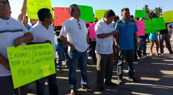
January 2016 march by owners of tortillerias asking for state government help

January 2016 march by owners of tortillerias asking for state government help

He also stated that 36 businessmen were kidnapped and tortured in the central region of Guerrero in the first two months of 2016, with most of the victims being associated with the tortilla industry. “It wasn’t a coincidence”, he said, “that a national survey named Chilpancingo as the country’s worst city to live in. Crime has put an end to everything: investments, jobs, and the desire to make a family here. But if you think the situation here is in a critical state, you should go to Acapulco. Here, the tortilleros are kidnapped, but there they are being killed.” According to Arcadio Castro, leader of the Tortilla Association of Guerrero, 20 tortilla workers lost their lives in 2015 in clashes with organized crime.

The previous chief of police of Acapulco was dismissed after he failed to pass control examinations, known as trust tests, designed to identify those with possible links to organized crime. His replacement expects some 700 of his current force of 1901 municipal police will also fail their next control exams. Given his current budget, he has no hope of renovating his police force with younger, healthier, law-abiding officers. The assault on the tortilla industry is generally not felt in the tourist areas of the city.

In 2010 UNESCO included the traditional Mexican cuisine of Michoacán in its list of the Intangible Cultural Heritage of Humanity, in large part based on the multiple uses and cultural centrality of corn in Mexican traditional cooking. This decision was very publicly celebrated by the tortilla industry. Unhappily, today, the tortillerias of Guerrero are struggling to survive the extortion rackets of the local drug cartels.

Main source:

Oscar Balderas. Drug Cartels Are Taking Over the Tortilla Business in Mexico. VICE News, , 16 March 2016; article re-published in Business Insider.

Related posts:

Mexico’s vehicle industry

 Teaching ideas, Updates to Geo-Mexico  Comments Off on Mexico’s vehicle industry
Dec 272014
 

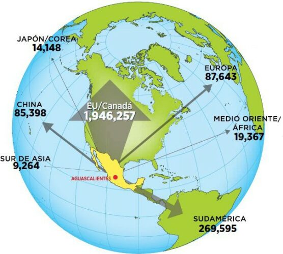
Mexico is one of the world’s “Top Ten” countries for vehicle production and for vehicle exports. In 2014, it has overtaken Brazil to become the world’s 7th largest vehicle producer and fourth largest exporter. 80% of Mexico’s production of around 3.3 million vehicles in 2014 were made for export. The trade surplus generated by the automotive sector exceeded 47 billion dollars in 2014.

auto-exports-forbes

Mexico’s vehicle exports in 2014. Credit: Forbes, México.

The industry attracts large amounts of Foreign Direct Investment (FDI). Vehicle assembly plants provide around 65,000 jobs, with a further 85,000 employed in distributorships nationwide and a whopping 450,000 employed in the autoparts sector.

The autoparts sector along produces items worth $80 billion/year, but Mexico also has to import components made elsewhere worth a further $35 billion. Clearly, this offers some opportunities for additional investment aimed at import substitution. Most of the opportunities are likely to be for Tier 2 companies. It is customary to divide the autoparts sector into three distinct parts: OEM, Tier 1 and Tier 2. OEM (Original equipment manufacturer) refers to companies that make a final product for the consumer marketplace (eg Volkswagen). Tier 1 companies are direct suppliers of components to OEMs, and Tier 2 companies are the key suppliers of parts or raw materials to Tier 1 suppliers.

Total production in 2014 topped the 3 million barrier, and the Mexican Automotive Industry Association (AMIA) believes production could reach 4 million units by 2015 and 5 million by 2020.According to  AMIA, the best selling models on the domestic market are the Aveo (GM), Jetta (VW), Versa and Tsuru (both Nissan).

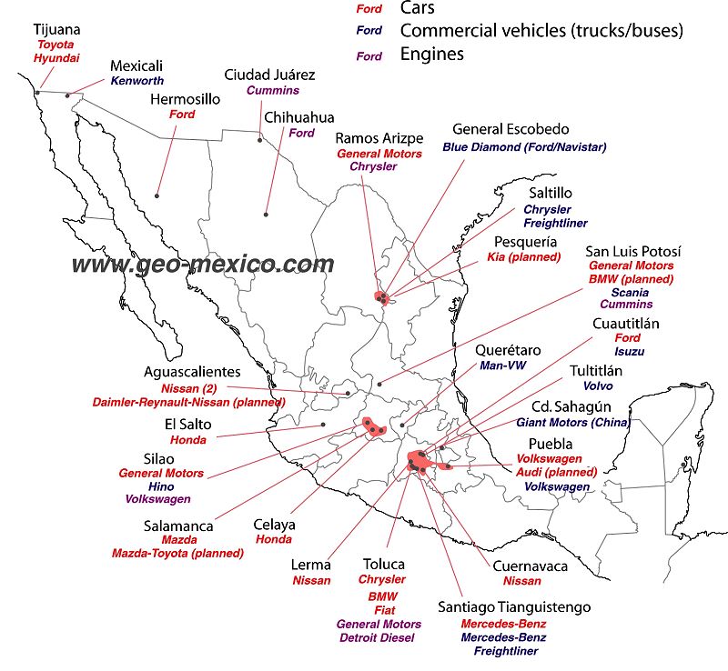
There are about 30 vehicle assembly plants in Mexico, manufacturing many brands of cars and trucks (see map). In addition, there are 1200 firms specializing in making parts for vehicles.

Vehicle manufacturing firms that have announced or confirmed major new investments during 2014 include:

  • Chrysler – 1.25 billion dollars to expand its assembly plant in Saltillo and manufacture a new line of Tigershark engines.
  • Nissan – to open its second plant in Aguascalientes.
  • Mazda – an additional 120 million dollars for its plant in Salamanca (Guanajuato), where it will manufacture several Mazda models as well as one Toyota model.
  • GM – investments worth 690 million dollars, divided  between its plants in Silao (Guanajuato), San Luis Potosí and Toluca (State of México).
  • Audi – about to open a 1.3-billion-dollar plant in San Jose Chiapa, near Puebla.
  • VW – 700 million dollars investment to adapt production lines in Puebla to produce its redesigned Golf hatchback.
  • Kia – plans to build a $1 billion vehicle assembly plant at Pesquería in the state of Nuevo Leon (scheduled to open in 2016) to produce up to 300,000 vehicles a year. The new plant is expected to generate a further 1.5 billion dollars in investment from firms seeking to join Kia’s supply chain.

This map is an updated version of the map we included in Where are Mexico’s vehicle assembly plants located? (2011).

Vehicle assembly plants in Mexico, 2014

Vehicle assembly plants in Mexico, 2014. Credit: Tony Burton/Geo-Mexico; all rights reserved.

As the map shows, certain areas of Mexico have attracted more investment in vehicle assembly plants than other areas. The two largest existing concentrations are focused on Toluca in the State of México, and on Saltillo-Ramos Arizpe in northern Mexico. However, the fastest growing cluster is in the central state of Guanajuato.

Virtual visit to the Chrysler plant in Saltillo (video, no commentary):

For a series of discussion questions related to this map and the vehicle assembly industry, see our earlier post – Where are Mexico’s vehicle assembly plants located?

Related posts:

The financial flows involved in Mexico’s vehicle manufacturing industry

 Other, Teaching ideas  Comments Off on The financial flows involved in Mexico’s vehicle manufacturing industry
Sep 192011
 

In previous posts, we have seen Where Mexico’s vehicle assembly plants are located, as well as looked at some of the reasons for Mexico’s success in this industrial sector and examined Mexico’s vibrant autoparts sector.

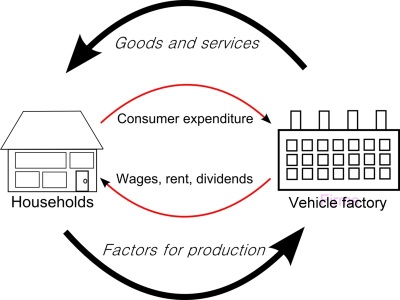
In this post we analyze the varied financial flows involved in the industry. Both local and international financial flows underpin vehicle manufacturing in Mexico.

financial flows

The following are some of the most important financial flows in the vehicle manufacturing sector.

  • International financial flows are in green
  • Domestic/local financial flows are in magenta

1. Foreign firms form Mexican subsidiaries and invest in Mexico; start-up capital to construct the factory and set up the business comes almost entirely from outside the country and enters Mexico as FDI. In recent years, FDI for auto firms has varied from $1 billion to $3 billion.

2. In many cases, local partners are involved, and they also contribute some of the start-up funds.

3. The factories employ workers, in some cases several thousand of them. These workers earn wages and spend most of their wages in the local economy. Each manufacturing job therefore has an economic multiplier effect, and generates more (indirect) jobs in the local economy. These jobs include positions in shops, services, transport, banking, auto-repair, etc. It is estimated that the economic multiplier for vehicle manufacturing is 3:1 – in other words, for every dollar spent in the industry three more are spent in the economy.

4. The factories purchase parts (components), some from Mexican suppliers, and some from overseas.

5. The factory produces vehicles, some of which are sold in the local market, via a series of vehicle distribution/sales points. This generates smaller two-way financial flows within the country.

6. Most of the parts and vehicles made in Mexican auto factories are exported. This generates another major financial flow, as purchasers overseas send funds back into Mexico to pay for their goods. This financial flow (a) allows production to continue and (b) generates profits for the factory owners (the car firms and shareholders).

7. The majority of these profits leaves Mexico, and is repatriated to the corporation’s home country, but both the workers in the factory, as well as the factory owners, pay taxes (state and federal) which remain in Mexico. In the case of shareholders, it is usually a financial flow towards their home country.

Previous posts in the mini-series:

Class exercise:

Use the description of financial flows above to draw an annotated diagram or a map to show the financial flows associated with the manufacturing of vehicles in Mexico. If you can think of additional flows that might be important, add those as well. Compare your diagram/map with that of other students and discuss the results.

Mexico’s vibrant autoparts sector

 Other  Comments Off on Mexico’s vibrant autoparts sector
Sep 102011
 

In previous posts in this mini-series, we have seen where Mexico’s vehicle assembly plants are located and looked at some of the reasons for Mexico’s success in this industrial sector. In this post, we consider the importance of the autoparts industry.

Each year, Mexico makes about 2 million vehicles, of which about 1.5 million are for export. Vehicle manufacturing is heavily dependent on parts manufacturers and suppliers. Vehicle assembly plants often require parts to be delivered in a “just in time” basis, to reduce the costs associated with warehousing and inventory. Mexico’s autoparts industry has grown rapidly in the last decade, and now accounts for about 7% of all the GDP derived from manufacturing activities, and for more than 8% of all manufactured exports.

The autoparts sector comprises about 1100 companies, one-third of which are Mexican-owned or controlled. Autoparts manufacturers employ more than 400,000 workers nationwide and exports of autoparts to the USA are worth more than $25 billion a year.

Car factories breed tire factories. Bridgestone, the Japanese tire-maker, and Pirelli, its Italian counterpart, are both investing in Mexico this year, expanding their production facilities and supply of tires to the North American market. Bridgestone is spending $100 million to upgrade its plants in Cuernavaca (Morelos) and Monterrey (Nuevo León), allowing production to rise to 10 million tires a year. Bridgestone also operates a retreading facility for truck tires in León, Guanajuato. Meanwhile, Pirelli is building a 210-million-dollar factory in Silao (Guanajuato) which will turn out 3 million high performance tires each year.

Good-Year campaign to recycle tires

Goodyear recycles tires

Related links:

For a useful map of major scrap tire piles either side of the border and a scary count of scrap tires, see Border 2012: U.S.–Mexico Border Scrap Tire Inventory, Summary Report (May 2007) (pdf file)

For some other (fun and extraordinary) ideas as to how old tires can be re-used, see Tires as Art.

Can Mexico’s industry compete with China?

 Excerpts from Geo-Mexico  Comments Off on Can Mexico’s industry compete with China?
Feb 262010
 

In recent years, Mexico has faced increased competition in world markets from China and other Asian countries. Mexico’s contribution to US imports peaked at about 12% in 2003 but has since fallen to around 10%. Chinese imports to the USA overtook Mexican imports in 2003 and now account for 15% of the total market.

According to Mexico’s central bank, Mexico’s lost market share between 2001 and 2005 was worth $27 billion, equivalent to 15% of all non-petroleum exports. Some multinationals closed their assembly facilities in Mexico and moved them to China.

What are China’s advantages?

The two most important ones are wage rates and the much larger local market. The average hourly wage for manufacturing in China is $0.66, compared to $2.13 in Mexico. China also offers more incentives for foreign investment. The companies that have moved are manufacturers of textiles, electronic items and auto-parts; these footloose industries do not have complex and expensive plants (unlike steelworks and chemical plants for example) and can therefore relocate relatively easily. While most have relocated in China, some have preferred South Korea or India.

What are Mexico’s comparative advantages over China?

Mexico’s major advantage is proximity to the US market. Shipping a standard 40-foot container from Mexico to the USA costs less than half the cost from China. Mexico also has a more educated workforce, with about one-quarter of the population having completed secondary education, compared to less than 17% in China. The productivity of Mexico’s workforce is slightly higher than in China, and the country also retains a slight edge over China in terms of its legal system. In an effort to stem the outflow of jobs, the Mexican government has opened several high-tech industrial parks, such as Silicon Border in Mexicali, and these appear to be having some success.

[Excerpt from chapter 20 of Geo-Mexico: the geography and dynamics of modern Mexico.]

Dec 242017
 

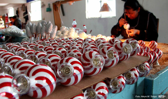
Some parts of Mexico have been working on Christmas for most of the year… For example, the manufacturing of beautiful handmade Christmas tree decorations is the main industry today in the former gold and silver mining town of Tlalpujahua in the state of Michoacán. The production of Christmas ornaments in Tlapujahua has a great series of photos by Arturo Toraya of Notimex, showing some of the steps involved.

ornaments-2

As the accompanying text explains, “Making baubles for Christmas trees is the main source of jobs in the town, which is now one of the top five producers in the world. Due to their quality, 90 percent of the total production is exported to the U.S. and Canada. There are 200 family workshops in the town with seven-hour shifts, and each worker can make up to 550 baubles per day. Each workshop decorates about 500 per day. Red, blue, green and yellow are the top selling colors in Mexico, while black, brown and grey are more popular in the U.S.”

The village of Tzintzuntzan, on the shores of Lake Pátzcuaro, also in Michoacán, is another settlement where Christmas seems to be a year-round source of inspiration. The village handicraft market is a cornucopia of straw work in every conceivable color, design and size, which make ideal Christmas decorations or gifts.

Happy Christmas from Geo-Mexico! – ¡Feliz Navidad!

Craft market in Tzintzuntzan, Michoacan

Craft market in Tzintzuntzan, Michoacan

Related posts:

Is Jalisco the most “Mexican” state?

 Other  Comments Off on Is Jalisco the most “Mexican” state?
Jan 092017
 

Tapatíos (residents of Guadalajara) and Jaliscienses (residents of Jalisco) often brag that they live in the most “Mexican” area of the country. Are these boasts truthful? This is not an easy question to answer. It involves looking at a broad range of evidence.

Jalisco’s climate and natural ecosystems are very diverse like the country as a whole. It is the only state with all of the country’s five principal natural ecosystems (tropical evergreen forest, tropical deciduous and thorn forest, temperate forest, grassland and mesquite-grassland, and arid and semi-arid scrubland) [Geo-Mexico, page 31]. Furthermore, Jalisco has Lake Chapala, the country’s largest natural lake as well as the Colima Volcano, one of the most active in the country. Certainly from a physical geography perspective Jalisco appears the most representative of Mexico as a whole. (For other natural wonders of Jalisco see John Pint’s website: http://ranchopint.com).

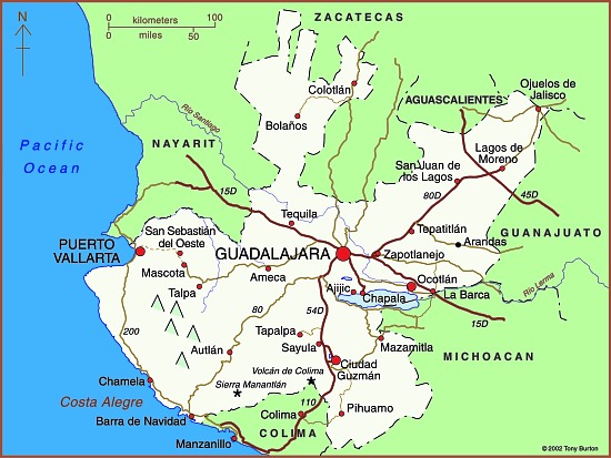
Map of Jalisco state

Map of Jalisco. Copyright 2010 Tony Burton. All rights reserved.

Jalisco’s socio-economic characteristics are also representative of Mexico. Its population has an average growth rate and is distributed among a very large city, secondary and smaller cities, extensive farming communities and isolated indigenous areas. While its adjusted per person income is just below the national average, its human development index (composed of infant mortality rate, adult literacy, school enrollment ratio, and adjusted average personal income) is slightly above. Jalisco is similar to Mexico regarding the main economic sectors of agriculture, industry and services, including tourism.

From a tourism perspective, Jalisco includes everything Mexico has to offer: fantastic beach resorts, urban cultural and artistic attractions, natural wonders, significant indigenous areas and impressive archeological sites. On the other hand, Jalisco is not representative in that it is the leading agricultural state (first in production of corn, beef, pork, poultry, milk and eggs). It is also more predominantly Catholic and politically more conservative than Mexico as a whole. Aside from these two exceptions, Jalisco is quite representative from a socio-economic perspective.

Perhaps cultural aspects are the most important in determining the most “Mexican” of the 32 states. Here Jalisco really stands out. It is the birthplace of such stereotypical Mexican cultural characteristics as charrería (Mexican horsemanship), jarabe tapatío (Mexican hat dance), mariachi music, and tequila, the national drink.

In conclusion, the available evidence appears to support the boasts of some Tapatíos and Jaliscienses that they live in the “most Mexican” area of the country.

Many aspects of Mexico’s culture feature in Geo-Mexico: the geography and dynamics of modern Mexico, a handy reference guide to all aspects of Mexico’s geography. If you have enjoyed this post, consider gifting a copy of Geo-Mexico to someone you know.

Alexander von Humboldt’s visit to Mexico, 1803-1804

 Other  Comments Off on Alexander von Humboldt’s visit to Mexico, 1803-1804
Sep 292016
 

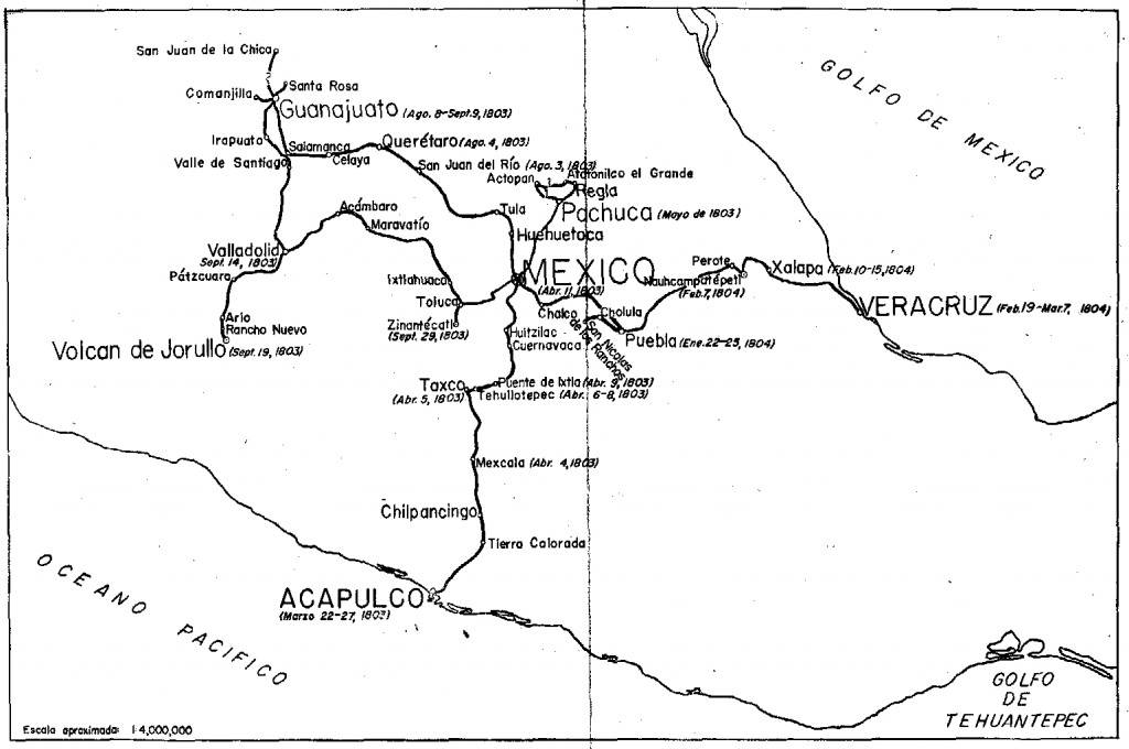
Alexander von Humboldt‘s visit to Mexico began in Acapulco on March 22, 1803, and lasted for almost a year. (He left Mexico via Veracruz for the USA on March 7, 1804.) In his year in Mexico, Humboldt had been incredibly busy. He had measured, recorded, observed and written about anything and everything, with remarkable industry and accuracy. He had climbed mountains, burned his boots on active volcanoes, descended into mines, recorded geographical coordinates, and collected numerous specimens and antiquities. Humboldt’s Political Essay on the Kingdom of New Spain was the first systematic scientific description of the New World. It appeared in 1811, and marked the birth of modern geography in Mexico. His figures and ideas were used and quoted by writers for many many years.

Humboldt had also drawn a large number of maps, drawings and sketches and it can rightly be claimed that the modern era of Mexican map-making began with Alexander von Humboldt, and was then developed further later in the 19th century by cartographers such as Antonio García Cubas.

Humboldt's route in Mexico

Humboldt’s route in Mexico. Click to enlarge

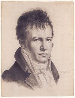
Alexander von Humboldt (Self-portrait c1814)

Alexander von Humboldt (Self-portrait c1814)

The map above shows the route followed by Humboldt during his time in Mexico. The map comes from the book La obra de Alexander von Humboldt en México by Rayfred Lionel Stevens-Middleton  (Mexico D.F.: Instituto Panamericano de Geografía e Historía, 1956). This hard-to-find work is a comprehensive account of Humboldt’s time in Mexico and of his significance for the development of what the author refers to as “modern geography”.

The map of Humboldt’s route in Mexico includes his various side trips such as those to Jorullo Volcano and Santa María Regla.

Humboldt was keen to see Jorullo Volcano, since it was a rare example of a brand new volcano, one of only a handful of volcanoes that have emerged on land anywhere in the world in historic times. Jorullo first erupted on 29 September 1759 and activity continued for 15 years until 1774. Two centuries later, and about 80 km (50 miles) away, Paricutín Volcano burst into action for the first time, in a farmer’s field in 1943.

Santa María Regla, in the state of Hidalgo, about an hour’s drive north of Mexico City, is the best known location in Mexico for basalt columns. The columns, up to 40 meters tall,  are attractively located on the side of a canyon, with a waterfall tumbling over some of them:

Despite only seeing a relatively small part of the country (New Spain as it then was), Humboldt was able to make some generalizations about geography in general, and Mexican geography in particular, that have stood the test of time remarkably well. For example, he was the first to describe the vertical differentiation of climatic and vegetation zones in Mexico. Writing in 1811, he proposed the terms tierra caliente, tierra templada, and tierra fría, terms still widely used by non-specialists today:

Related posts:

Note: this post was first published on May 7, 2012.

Video of the Sea of Cortés (Gulf of California)

 Books and resources  Comments Off on Video of the Sea of Cortés (Gulf of California)
Aug 232016
 

This PostandFly video explores the islands of San Jose, San Francisco and Espiritu Santo. The Sea of Cortés (Gulf of California) is the body of water that separates the Baja California Peninsula from the Mexican mainland. The Sea of Cortés is thought to be one of the most diverse seas on the planet, and is home to more than 5,000 species of micro-invertebrates. A large part of the Sea of Cortés is a UNESCO World Heritage Site.

Several rivers feed the Sea of Cortés, including the Colorado, Fuerte and Yaqui. The Sea of Cortés has more than 300 estuaries and other wetlands on its shores, of which the delta of the Colorado River is especially important. The vast reduction in the Colorado’s flow has negatively impacted wetlands and fisheries.

Previous Geo-Mexico posts on this area of Mexico include:

Aug 152016
 

Avid Geo-Mexico readers will know that we included a few paragraphs about the Happy Planet Index in our 2010 book, which we later quoted in this 2013 post, Mexico and the Happy Planet Index.

The latest (2016) Happy Planet Index (HPI), which uses slightly modified criteria, shows that Mexico has risen to 2nd place in the world rankings, behind Costa Rica, but ahead of Colombia, Vanuatu and Vietnam and well ahead of the U.S. (#108) and Canada (#85).

The Happy Planet Index is a compound index that combines four measures:

  • life expectancy
  • well being (life satisfaction)
  • ecological footprint
  • inequality

The HPI looked at data for 140 countries. For life expectancy, Mexico ranked #39, for well being #11, for ecological footprint #77 and for inequality #60.

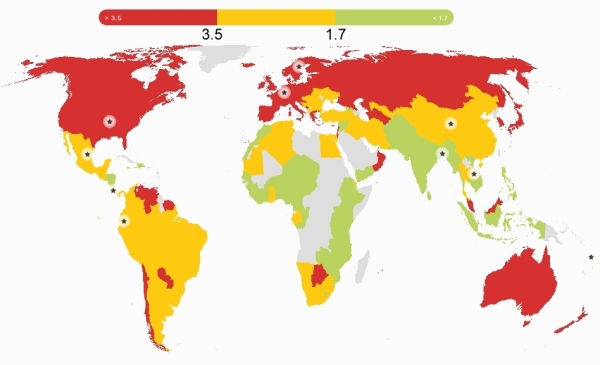
Global pattern of ecological footprint. Source: HPI report, 2016.

Global pattern of ecological footprint. Source: HPI report, 2016.

The world map for ecological footprint shows the global pattern. The colors show three categories for ecological footprints, those below 1.7, those between 1.7 and 3.5 and those that exceed 3.5, where the numbers are global hectares (gha) per person.

These two sections from the Happy Planet Index country report for Mexico are a useful snapshot of where Mexico stands right now:

What’s working well in Mexico?

In recent years, massive steps have been taken to improve the health of the population of Mexico – notably achieving universal health coverage in 2012, making essential health services available to the entire population.

In 2014, a tax was imposed on sugary drinks with the express aim of tackling of obesity – this despite strong corporate opposition. The tax had already led to a 12% decrease in the consumption of such drinks by the end of the year.

Environmental sustainability is receiving growing political attention, and was included as one of five key pillars in Mexico’s National Development Plan for 2007–12. Mexico was the second country in the world to incorporate long-term climate targets into national legislation, and is taking important steps to conserve its forests and protect its rich biodiversity.

What could be improved?

Significant challenges remain for Mexico: economic inequality is a massive problem with a considerable gap between the richest and poorest – the top 20% of the population earns more than thirteen times as much as the bottom 20% of the population.

Mexico’s poverty rates are particularly high among indigenous people. Amnesty International has  highlighted Mexico’s human rights violations, especially relating to irregular migrants. On top of these issues, the importance of the oil industry to Mexico’s economy complicates its environmental efforts.

Mexico recently reached cross-party agreement on the Pacto por Mexico, a pact of 95 initiatives aiming to tackle some of these issues – an important step for the country’s future.

The HPI attempts to quantify an alternative vision of progress where people strive for happy and healthy lives alongside ecological efficiency in how they use resources. Mexico may have a high happiness index, but (like the rest of the world) it still has an awful long way to go to ensure a sustainable future for our grandchildren.

Related posts:

The continuing revitalization of Acapulco

 Mexico's geography in the Press  Comments Off on The continuing revitalization of Acapulco
Aug 082016
 

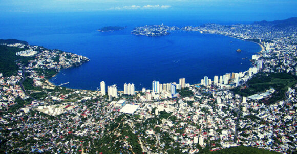
Acapulco is busy re-invigorating its tourist industry. In recent months, we’ve looked at the city’s improved public transit system known as Acabús and reported the news that Acapulco International Airport is getting a new, state-of-the-art, 18,800-square feet terminal building. The airport’s operator, Grupo Aeroportuario del Centro-Norte (GACN) says the 30-million-dollar terminal will be capable of handling 1.3 million passengers a year.

acapulco-bay-prob-public-domain

Now, Mexican firm Mundo Imperial, the tourist division of the vehicle financing firm Grupo Autofin, has announced a 1-billion-dollar Master Plan to help revitalize Acapulco, Mexico’s first jet set resort.

The plan aims to return the city to its former glory days by renovating the famed Mundo Imperial, Fairmont Princess and Pierre Marqués hotels, and adding several smaller boutique hotels and a medical center, as well as up-market homes and a high-end shopping plaza.

The project also includes an additional 700-room hotel, new tennis stadium, a hospitality training facility and an eco-adventure park. The plan, which will create around 10,000 jobs in total, will take five years to complete.

According to tourism officials, Acapulco’s reactivation as a tourist center is well under way. They claim that the port resort will host more than 40 major conferences this year, and that the city will be a port-of-call for more than 30 U.S. cruise ships.

Next year, Acapulco will once again host Mexico’s massive annual Tourism Fair, the Tianguis Turístico.

Related posts:

Mexico’s berry exports now exceed a billion dollars a year

 Mexico's geography in the Press  Comments Off on Mexico’s berry exports now exceed a billion dollars a year
Mar 152016
 

Berry production is one of the most dynamic segments of Mexico’s buoyant agricultural sector, and exports of berries (strawberries, raspberries, blackberries and blueberries) in 2015 totaled 1.1 billion dollars, according to preliminary figures.

Last year, 99.6% of all U.S. imports of fresh strawberries came from Mexico and 27% of all imported raspberries, blackberries and blueberries. Berry-growing, concentrated in Baja California, Jalisco, Michoacán, Guanajuato and Puebla, occupies around 25,000 hectares of farmland nationwide and provides 120,000 permanent jobs.

Postage stamp, strawberry exports

Postage stamp, strawberry exports

Strawberries were introduced from the USA to Mexico in the 1850s. Major commercialization of strawberries began after the second world war, following the construction of Mexico’s first freezing plant for berries. The two major strawberry-growing states today are Guanajuato (around Irapuato, “Mexico’s strawberry capital”) and Michoacán, where the cultivation of strawberries is concentrated around the city of Zamora.

Mexico has also begun exporting berries to China, a market with massive potential for future growth.

Berry farming has significantly changed the agricultural landscape of some areas. For example, sugarcane fields around Los Reyes, Michoacán, have been converted to blackberries over the past 15 years, and now supply 96% of Mexico’s total production of that fruit.

Related posts

Geo-Mexico has many other agriculture-related posts (easily found via our tag system). They include posts about the geography of growing/producing Christmas trees, cacao, honey, sugarcane, coffee, chiles, floriculture, tomatoes, tequila, horticultural crops and oranges.

We also have an index page dedicated to agriculture:

Mar 032016
 

To make it easy to search for specific topics on Geo-Mexico, we add an occasional index page as a starting point for the best links relating to particular key topics. Note that the entire site can easily be searched via our search function, categories (right hand navigation bar on every page) and tags (left-hand navigation bar).

The geography of Mexico’s drug trade: an index page

The Basics

Economics:

Drug War Violence and Crime

Drug Money

Other

Index pages on other topics:

Mar 052015
 

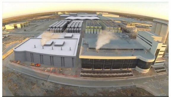
The Nava brewery, which started operations in May 2010, was built by Grupo Modelo but subsequently sold in 2013 to Constellation Brands, the U.S. company that holds the rights to import Modelo products into the U.S.

Nava brewery

Nava brewery. Credit: Constellation Brands

Constellation Brands (founded in 1945 and based in Victor, New York) is a leading international producer and marketer of beer, wine and spirits with operations in the U.S., Canada, Mexico, New Zealand and Italy.

The Nava brewery is the world’s largest brewery of its kind (see this video overview from company webpage), with about 2000 employees and a brewing capacity of 20 million hectoliters of beer a year. A planned expansion (see 26-second video) will increase capacity to 30 million hectoliters.The plant produces Grupo Modelo brands such as Corona, Corona Light, Negra Modelo and Modelo Especial, under license for export to the U.S.

Where is it?

The beer brewery and bottling plant is located in the Nava municipality in the northern state of Coahuila, about 21 km (13 mi) from the border town of Piedras Negras. It is built alongside highway 57 and spreads over 334 hectares (825 acres) of a greenfield site.

Why is it located in Nava?

The major advantages of this location include:

  • the availability of good quality water
  • proximity to the U.S. border and the U.S. beer market
  • presence of good road, rail and power infrastructure

How does the brewery work?

The brewery is a three-story brewhouse with large metal silos, about 1.6 km (1 mi) of conveyors and four pasteurizers. The facility consists of two brewhouses with malt intake, vacuum evaporation and energy recovery systems, 70 cylindro-conical fermentation and storage tanks, seven clean-in-place (CIP) stations, a yeast cellar with 16 tanks and continuous microfiltration (CMF), 30 pressure tanks and three filtration lines with 1,200 hectoliters/hour capacity each, and a Siemens automated process control system.

The brewery uses rice, barley malt, corn grits and water to produce beer. The feedstock is transported by trains to the plant and stored in silos. A 60 km (37 mi) pipeline connects the brewery to a mountain aquifer supplying about 20 million cubic meters of water a year. The site includes its own wastewater treatment plant.

A raw materials supply system handles the raw materials in bulk and conveys them to the brewhouse, where they first enter a collection bin, and then a mash tun, where water is added. The mixture is then pumped along a pipeline to the cereal cooker of the brewhouse.

Two brew systems consisting of mash tuns and cereal cookers are designed to efficiently use the internal heat. These heaters can also clean them automatically by CIP (clean-in-place) technology. Fermentation takes place in unitanks configured with automated clarification, purging systems and turbidity monitoring. The brewery consumes less than 3 liters of water for each liter of beer. The carbon dioxide reclamation capacity of the brewhouse is about 4,000 kg/hour.

The three bottling lines have the capacity to handle 144,000 bottles/hour, while a canning line outputs up to 66,000 cans/hour.

Filling, pasteurizing and cap feeding is handled by 37 robotic machines. Output is linked to the warehouse by automated trolleys. The automated warehouse is equipped with digisat satellite, a state-of-the-art warehouse management system, and can store about 63,000 pallets.

The high level of automation means that this beer manufacturing and bottling plant has operational costs about 40% lower than the seven older breweries that still belong to Grupo Modelo.

Related Posts:

The geography of dengue fever in Mexico

 Updates to Geo-Mexico  Comments Off on The geography of dengue fever in Mexico
Dec 112014
 

Preventing, diagnosing and treating dengue fever is a major public health issue in many parts of the world, including central America and Mexico. The disease is transmitted by mosquitoes. Infected patients develop a sudden high fever, usually accompanied by generalized body pain and a skin rash. The pain can be very severe, hence the disease’s common name of breakbone fever.

Several species of mosquito can transmit dengue, but female Aedes aegypti mosquitoes are the main transmitter of dengue in Mexico. These mosquitoes bite during the day, mostly in the period two hours either side of dawn and dusk. The mosquito bites an infected person and ingests blood with the dengue virus, which incubates in the mosquito for a period of 8 to 12 days. After that the mosquito can begin to transmit the virus by biting other people. From 5-7 days later any newly infected person is likely to have symptoms.

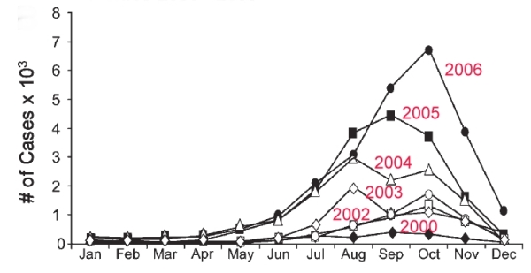
The graph below shows the monthly number of dengue cases in Mexico from 2000 to 2006. It is clear that most cases are reported between July and November, with very few cases occurring between December and May. This can be explained by Mexico’s climate. Almost of all of Mexico receives most of its rainfall between June and October. The mosquitoes that spread dengue need stagnant water to breed. There are far more small pools of water available for mosquito breeding in and immediately after the annual rainy season. Eliminating potential locations where water can collect and stagnate is an important element of dengue prevention programs.

Monthly incidence of dengue cases in Mexico, 2000-2006

Monthly incidence of dengue cases in Mexico, 2000-2006. Source: San Martín, Brathwaite et al (2014).

The graph also shows that the number of cases of dengue was increasing rapidly between 2000 and 2006. Indeed, numbers continued to rise until 2013 when more than 50,000 cases were reported for the year (an average of more than 4000/month). At first sight, this suggests that dengue prevention programs have not been very successful, but in fact the rise echoes what was happening worldwide. One possible, at least partial, explanation may be that changes in climate have allowed dengue mosquitoes to thrive in environments where they were previously scarce. People in such areas are unprepared for dengue; they may not have instituted prevention programs, and may have been slow to receive correct diagnosis. The migration of people affected by dengue from one region to another may also have helped the disease spread, provided there were host mosquitoes in the destination region.

The good news is that the number of dengue cases in Mexico in 2014 has fallen from its 2013 level by about 50%, so the dengue epidemic may finally be on the wane. As of 24 November 2014, 28,109 cases had been reported for the year, an average nationwide rate of 23.47 cases/100,000 people. Dengue is fatal in a relatively small number of cases, with 33 deaths reported in Mexico so far this year..

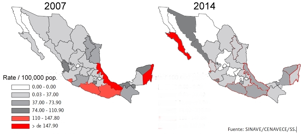
The total number of cases may finally be on the decline, but the figures for 2014, when looked at state by state, suggest that the spatial pattern of dengue cases in Mexico is changing. The two maps below compare the rate of cases per 100,000 people on a state-by-state basis for 2007 and 2014. (The color-coded key is identical for both maps).

Rates of dengue by state, 2007 and 2014

Rates of dengue by state, 2007 and 2014. Rates are cases / 100,000 population

In 2007, the highest rates of dengue were found in the states of Veracruz and Quintana Roo, with Oaxaca, Guerrero and Colima comprising the next category. (Those five states are the ones colored red on the 2007 map). At the other extreme, no cases were recorded in 2007 in the state of Baja California, or in several tiny states including Aguascalientes.

The pattern shown on the 2014 map is quite different. In general, rates of dengue at the state level have not increased in Mexico, but decreased. However, there is a clear shift in emphasis towards the north-west, where several states had much higher rates in 2014 than in 2007. The extreme example is Baja California Sur, where the rate for 2014 (up to 24 November) was a whopping 549.9 cases / 100,000 people, more than five times the rate registered in any other state. Equally apparent is the belt of low-rate states (from Chihuahua to the State of México) down the center of the country from the U.S. border to Mexico City. These states are at relatively high elevation where fewer mosquitoes are found.

The states of Baja California Sur, Veracruz, Sinaloa, Sonora and Guerrero account for 55% of the 28,109 confirmed cases of dengue fever reported in Mexico as of 24 November 2014.

Mexico’s Health Secretariat publishes maps of each state showing which municipalities have reported cases of dengue. These maps are updated weekly. The link is to a pdf document with maps for 2014 up to 24 November.

There is some good news. In 2015, Mexico will be the first nation in the world to get a new dengue vaccine, developed by French company Sanofi Pasteur. The company hopes to have manufactured more than 40 million doses by the first half of 2015, and has decided to introduce it first in Mexico, with the first vaccinations likely to be offered to the public late next year or early in 2016. In trials, the vaccine proved 60.8% efficient in preventing the disease.

Reference for graph:

José Luis San Martín, J.L., Brathwaite, O., Zambrano B, et al (2014): “The Epidemiology of Dengue in the Americas Over the Last Three Decades: A Worrisome Reality”; Am. J. Trop. Med. Hyg., 82(1), 2010, pp. 128–135

Related posts

The market for commercial and industrial real estate in Mexico

 Mexico's geography in the Press, Other  Comments Off on The market for commercial and industrial real estate in Mexico
Mar 012014
 

A recent snapshot of the industrial real estate market in the last quarter of 2013 compares progress in three industrial regions in Mexico: Northern Mexico, Central Mexico and the Bajío Region. The snapshot comes from the report ‘Industrial Markets in México (Q4 2013)‘ by Jones Lang LaSalle, a global real estate services firm specializing in commercial property management, leasing, and investment management.

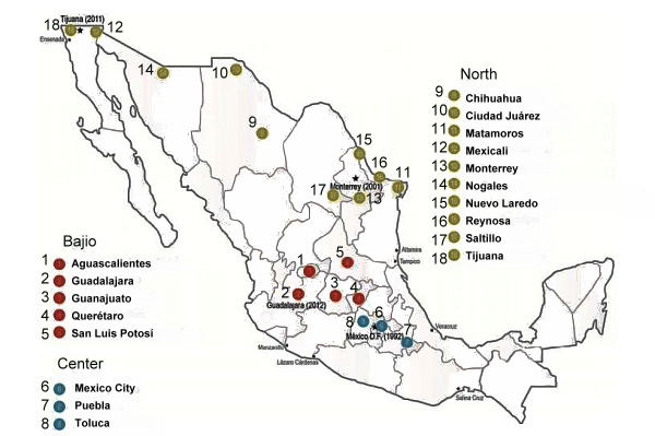
Cities included in industrial real estate study

Cities included in industrial real estate study (Jones Lang LaSalle)

The pattern of commercial and industrial real estate in Mexico

The five main cities of the Bajío Region (Aguascalientes, Guadalajara, Guanajuato, Querétaro and San Luis Potosí) are booming in terms of commercial and industrial real estate. In the final quarter of 2013, the region added about 550,000 m2 of commercial and industrial space. This was more than double the additional space added in Central Mexico (Mexico City, Toluca and Puebla) and close to the total amount (614,000 m2) spread between 10 cities in northern Mexico (see map).

In the North Region, “Tijuana has been occupying vacant space… and Ciudad Juárez is on its way to recovering from low rents and high vacancy”, while the automotive sector is driving growth in Saltillo-Ramos Arizpe.

The Central Region is helped “by third party logistics companies that grow their business and footprint in Mexico City’s surroundings”, while “Toluca and Puebla grew mainly because of the car manufacturing demand for space.” Commercial rents rose in Mexico City and in Toluca. “Big Box requirements keep driving this market. Development has been very active at the Tepotzotlán toll booth surroundings.”

The Bajío Region has consolidated “with new industrial parks related not only to the new car manufacturing plants, but also for new investments related to aerospace, food and personal consumer” products.

Related posts:

The growth of the city of Monterrey, Mexico’s industrial powerhouse

 Excerpts from Geo-Mexico, Other  Comments Off on The growth of the city of Monterrey, Mexico’s industrial powerhouse
Oct 282013
 

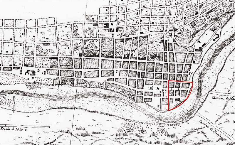
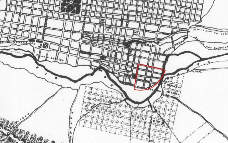
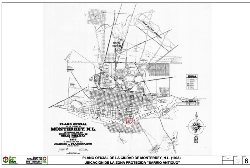
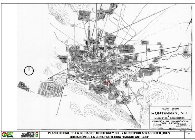
A series of historical maps of the city of Monterrey was published earlier this year in the city’s online Catalog of Buildings of Historic and Artistic Importance in Barro Antiguo, The maps, dated 1765, 1791, 1846, 1865, 1922, 1933 and 1947 respectively, offer a good basis for considering the urban growth of Monterrey, the industrial powerhouse of northern Mexico.

In chapter 22 of Geo-Mexico, the geography and dynamics of modern Mexico, we explained why, “Monterrey does not fit the general Latin American urban model as well as Mexico City or Guadalajara. First, it never really existed as a colonial city. Secondly, its development was more heavily dependent on industry. Thirdly, its relative wealth and progressive leadership in some ways make it more similar to a North American city than a Latin American city. It fits the model only in that it developed a definite high status sector in contrast to lower status industrial sectors, and eventually became spatially fragmented.”

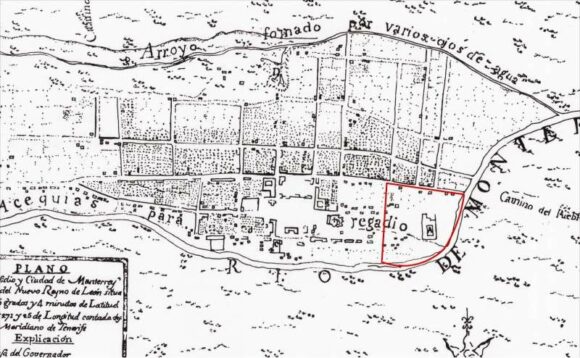
But just how did Monterrey develop as a city? In each of the following historical maps of Monterrey, Barrio Antiguo (16 blocks in size in the present-day city) is marked by a red quarter-circle, which is an easy way to check each map’s orientation and scale. Monterrey was founded in 1596. The earliest map in our series, for 1765, shows that, even by that date, Monterrey was still a relatively small settlement situated between a (seasonally dry) “stream formed by various springs” (to the top of the map, north) and the seasonally-dry “Monterrey River” (now called the Santa Catarina River). The Barrio Antiguo is shown as mostly an empty area, with only one major construction.

Monterrey 1765

Monterrey 1765

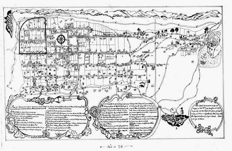
Very little has changed by 1791 (see map below: note that this map is oriented south-upwards), though the Barrio Antiguo has now been developed, and is shows as having several streets in a clear grid pattern:

monterrey-1791

Monterrey in 1791

The grid pattern for Barrio Antiguo is equally evident in the details of the map in 1846:

monterrey-1846

Monterrey in 1846

As of 1846, no development is shown on the south bank of the Santa Catarina River, though tracks are shown heading east and south-east respectively from the city. The next map, for 1865, shows that the city is beginning to expand to the south. A substantial settlement is developing on the south bank, more of less opposite the Barrio Antiguo. Note, though, that this map shows only part of the city:

monterrey-1865

Monterrey in 1865

Clearly, Monterrey only emerged as a real city after the colonial period which ended in 1821. The relatively small city did not experience real growth until late in the 19th century when it became connected by railroad and started to attract industrial development.

Early in the 20th century, investors built the then largest iron and steel works in Latin America a few kilometers east of the city center. Many related industries located nearby. These industries and the railroad, which ran east–west about four kilometers (2.5 mi) north of the city center, stimulated early industrial development in these directions. Developers established low income housing tracts for industrial and other workers on the east, north and west periphery of the city. Neighborhoods for the wealthier classes were developed south of the city center.

By 1933, Monterrey has grown significantly in area, especially towards the north:

monterrey-1933-whole-city

The city of Monterrey in 1933

Between 1933 and 1947, the city continues to expand, with many areas being infilled with residences:

monterrey-1947

The city of Monterrey in 1947

The city experienced another surge of industrialization and immigration in the 1950s and 1960s. Industrial development continued after 1970 when the national government implemented policies to shift development away from Mexico City. Monterrey became a major producer of steel, metal fabrication, cement, beverages, petrochemicals, food, telecommunications, auto parts, glass, and house furnishings. It also developed into a major financial center and one of the wealthiest and most progressive cities in the country.

Low income housing became a serious problem after the 1960s as the inner city tenements became extremely crowded. The government was not sympathetic to irregular housing schemes, so low income groups established numerous illegal squatter settlements on vacant land near the industrial zone. Government made a few efforts to remove these, but most survived and eventually became regularized.

The high status sector expanded south-west into San Pedro Garza García, which became one of the wealthiest municipalities in Mexico. The high overall income and wages in the city meant that many workers could afford home ownership and private automobiles. As a result, many gated communities (large and small) and suburban shopping malls were built around the urban periphery. The urban area became relatively fragmented with many low income residential zones located near high income areas.

Source of the maps used in this post:

Other posts about the urban geography of Mexico’s cities:

Several major Mexican companies among the “Global Challengers”

 Updates to Geo-Mexico  Comments Off on Several major Mexican companies among the “Global Challengers”
Apr 192013
 

The Boston Consulting Group (BCG) periodically identifies 100 companies from rapidly developing economies as “global challengers.” (Bcgperspectives, “Introducing the 2013 BCG Global Challengers“).

BCG has identified 100 companies for this list in 2006, 2008, 2009, 2011 and 2013. They focus on companies in developing Asia (excluding Japan, South Korea, Taiwan, Hong Kong and Singapore), Eastern Europe, the Commonwealth of Independent States, the Middle East, Latin America, and Africa. Companies considered for the list must have annual revenues of at least $1 billion, overseas revenues at least 10% of total revenues or $500 million, and be focused on building a truly global footprint.

The biggest emerging economies have dominated. In 2006 the list included 44 Chinese companies, 21 Indian companies and 12 from Brazil. Russia was next with seven followed by Mexico with six. The dominance of the big three declined from 77 in 2006 to 63 in 2013. One reason for this is that some of the countries on the list “graduated” from the challengers list to become full global competitors.

In 2013, China led with 30 companies, followed by India with 20 and Brazil with 13. Mexico was 4th with seven companies, followed by Russia with six, South Africa with five, Thailand with four and Turkey with three. Countries with two companies on the list are Chile, Malaysia, and Saudi Arabia. Those with one company on the list are Argentina, Colombia, Egypt, Qatar and United Arab Emirates.

The seven Mexican companies in the group are Alfa, American Movil, FEMSA, Gruma, Grupo Bimbo, Mabe, and Mexichem. One Mexican company, Cemex, has “graduated” from the “challengers” list. It is the world’s largest building materials supplier and 3rd largest cement maker. Cemex now operates in 50 countries on six continents and is the leading cement seller in the USA. Revenues in 2012 were $15 billion.

ALFA is the world’s leading manufacturer of high-tech aluminum engine heads and blocks through its subsidiary Nemak. Its other major subsidiaries are Alpek (petrochemicals), Sigma Alimntos (foods) and Alestra (electronics and telecommunications). Revenues in 2012 were $15 billion.

América Móvil. operates Telmex and Telcel, the world’s fourth largest cell phone operator with 160,000 employees and over 250 million subscribers mostly in Latin America and the USA. Its revenues in 2012 were $59 billion. It is a candidate to graduate from this “challengers” group in the near future.

Gruma is the world’s largest producer of corn flour and tortillas. It has subsidiaries in the USA, China, UK, and Latin America. Revenues in 2012 were $5 billion.

FEMSA, based in Monterrey, is the world’s largest bottler of Coca-Cola. FEMSA also operates OXXO, the largest convenience store chain in Latin America. Revenues in 2012 were $18 billion.

Grupo Bimbo is the world’s largest bread maker and the biggest bread seller in the USA. Among its 100 brands are Arnold’s, Entenmann’s, Thomas’s English Muffins, and Sara Lee fresh baked products. Bimbo is the world’s 4th largest food company behind only Nestle, Kraft, and Unilever. Revenues in 2012 were $13 billion.

Mabe. is a leader in the production of large household appliances such as stoves, refrigerators, washers, dryers, etc. These are sold in 70 countries under the General Electric and Mabe brand names. It controls 70% of the market in Latin America. Revenues in 2012 were $4 billion.

Mexichem is a chemical company that operates throughout the Americas as well as in Europe and Asia. It exports to more than 50 countries, has over 10,000 employees, and earns over $4 billion annually.

Related posts

Mexican vehicle exports surge back after 2008-2009 recession

 Updates to Geo-Mexico  Comments Off on Mexican vehicle exports surge back after 2008-2009 recession
Dec 202012
 

The Great Recession related to US housing and banking failures in 2009 hit the Mexican vehicle industry very hard. Production in Mexico declined by 28% from 2.10 million units 2008 to 1.51 million units in 2009. This dropped Mexico to 10th in the world. However, production shot up 50% in 2010 to 2.26 million and grew to 2.56 million in 2011 (data from Mexican Automotive Industry Assn.) It is expected to hit 3.1million in 2012. This enabled Mexico to move past Spain and France into 8th place.

Virtually all of this growth has been in the export sector. In 2011, almost 84% of all vehicles made in Mexico were exported. In fact, sales of Mexican made new cars in Mexico dropped from 1.1 million in 2007 to 0.76 million in 2009. It only rebounded to 0.82 million in 2011. It is expected to increase 11% in 2012 to 1.0 million, still lower than the 2007 level.

In 2011, almost 84% of all vehicles made in Mexico were exported. This export percentage clearly suggests that these manufacturers are primarily focused on selling their Mexican made vehicles in the USA and Canada.

Production is expected to continue increasing rapidly in the years ahead as evidenced by the following recent news releases:

Source of data:

Mexican Automotive Industry Assn. “Mexico’s Automotive Production & Exports Hits Record High in November (2012)”  (pdf file)

Related posts:

Sep 292012
 

Industrial exports from Mexico are growing rapidly and diversifying. Some of this growth is coming at the expense of China and other Asian countries. For example, as Adam Thompson reported in the Financial Times, Siemens of Germany recently moved its facilities for assembling high voltage electrical equipment for power substations from China and India to Querétero, Mexico. By next year, most of the 160 parts for this equipment will also be produced in Mexico. Siemens has eight other factories in Mexico and over 6,000 employees. As a result of investments like this, Mexico now exports more manufactured products than the rest of Latin America combined.

It is well known that the USA imports a great deal of manufactured goods from China including toys, electronics, clothing, shoes, etc. But China’s market share of US imports has declined recently, from 29.3% in 2009 to 26.4% to day. On the other hand, Mexico’s market share has increased from 11.0% in 2005 to 14.2%. According to The Economist, “HSBC reckons that by 2018 Mexico will overtake Canada and China to become America’s main source of imports”.

Mexico’s location next to the giant US consumer market is a big factor (see “US firms are near-shoring jobs from China to Mexico”.

It is much faster and cheaper to ship goods from Mexico to the USA rather than from Asia. For example, it usually takes two to seven days from Mexico versus 20 to 60 days from China. Mexico’s locational advantage is particularly important for trendy time-sensitive goods and bulky items. For example, in 2009 Mexico became the world’s leading exporter of flat-screen TVs, surpassing South Korea and China. Mexico is also the leading supplier of smartphones for the US market. Furthermore, as Itizar Gomez Jimenez reports in “Beyond the Refrigerator Door: Success of the Electric Home Appliance industry in Mexico”, most of the large household appliances sold in the USA come from Mexico, including refrigerators, kitchen ranges, dishwashers, microwave ovens, washers and dryers.

Attractive wage rates in Mexico are also a consideration. A decade ago wages in Mexico were roughly four times those in China, but now they are only about 30% higher and the gap is closing (see, “Rising Chinese labor costs: good news for Mexico”). Less red tape under NAFTA also gives Mexico an advantage (see, “Can Mexico’s industry compete with China?”). Mexico is fully committed to globalization. It has free trade agreements with 44 other countries, twice as many as China and four times as many as Brazil. To date, drug war violence has not been a serious constraint to Mexico’s growing manufactured exports.

logo-made-in-mexicoMexico’s maquiladora export industries used to assemble mostly imported parts into finished products for export to the USA. Now, most of the parts are manufactured in Mexico for such industries as electronics, automobiles, appliances and airplanes. (see: “Mexico’s vibrant autoparts sector” and “The reasons why Mexico is fast becoming a key player in aerospace manufacturing). Mexico is also broadening its export market. In 2000, about 90% of Mexico’s exports went to the USA, but now it is down to 80%. Mexico is even exporting manufactured items to China such as the new Chrysler Fiat-500 micro automobile.

While Mexico manufactures products under the names of many foreign brands, it also has its own brands and OEM (original equipment manufacturer) companies that design and build products that are incorporated into foreign branded products. For example, Mexico’s Mabe designs and builds two-thirds of the gas ranges and refrigerators imported into the USA. Furthermore, most of the appliances sold under the General Electric brand in North and South America are manufactured by Mabe. LANIX, Mexico’s largest domestic electronics company, makes desktops, laptops, netbooks, tablets, LCD and LED TV and monitors and smartphones for a range of brand names.

A careful look around a typical household in the USA would reveal that many, perhaps a majority, of the durable manufactured goods would carry a “Made in Mexico” label, including automobiles, flat panel TVs, smartphones, all types of appliances, garden and small power tools, etc. etc.

Sources:

  • Adam Thomson, “Mexico: China’s unlikely challenger.The Financial Times, September 19, 2012 (registration required).
  • Itizar Gomez Jimenez, “Beyond the Refrigerator Door: Success of the Electric Home Appliance industry in Mexico” (pdf file). Cover Feature: Domestic Consume.

Related posts (specific industries):

Sep 202012
 

Mexico is rapidly becoming a world leader in vehicle production, which includes cars, commercial vehicles such as large trucks, pick-ups and SUVs (sports utility vehicles). Back in 1995, Mexico produced fewer than a million vehicles and ranked 12th globally. By 2011 it was making 2.68 million, placing it 8th in the world (see table). During the 16 year period, Mexico surpassed France, Canada, the U.K., Russia, Italy and Spain. China and India moved ahead of Mexico during the period.

Mexico’s impressive 1995 to 2011 growth of 185% was third among top vehicle producers, but trailed way behind the amazing growth of China at 1170% and India at 515%. Others experiencing significant growth include Brazil up 109%, Russia up 101%, South Korea up 84% and Germany up 35%. Except for Spain, which edged up less than 1%, all the other other major vehicle producers experienced significant declines in the number of vehicles produced: USA (- 28%), Japan (-18%), U.K. (-17%), France (-15%) and Canada (-12%). The data clearly indicate that vehicle production is shifting rather quickly from the major producers of past decades to a number of emerging economies with lower labor costs. Germany appears to be the only exception to this shift. In North America, production has shifted from the USA and Canada to Mexico, largely as a result of NAFTA.

2011 Production Statistics (Source: International Organization of Motor Vehicle Manufacturers)

Country Cars Commercial vehicles
Total Change from 2010
(millions of vehicles)
China 14.5 3.9 18.4 0.8%
USA 3.0 5.7 8.7 11.5%
Japan 7.2 1.2 8.4 –12.8%
Germany 5.9 0.4 6.3 6.9%
South Korea 4.2 0.4 4.7 9.0%
India 3.0 0.9 3.9 10.4%
Brazil 2.5 0.9 3.4 0.7%
MEXICO 1.7 1.0 2.7 14.4%
Spain 1.8 0.5 2.4 –1.4%
France 1.9 0.4 2.3 2.9%
Canada 1.0 1.1 2.1 3.2%
Russia 1.7 0.2 2.0 41.7%
TOTAL 59.9 20.2 80.1 3.1%


Mexico vehicle production grew by over 14% from 2010 to 2011, the fastest among all major producers except Russia, which advanced at a very impressive 42% (see table). Available data indicate that Mexico’s rapid growth has continued into 2012. Interestingly, the USA’s growth of 12% over its lackluster 2010 total placed it 3rd, ahead of India (10%), South Korea (9%) and Germany (7%). Surprisingly, Brazil and China grew by less than 1%, though China’s 2011 production level of over 18 million vehicles was over twice as many as its nearest rivals, the USA and Japan.

Just looking at commercial vehicles, which include pick-ups and SUVs, Mexico ranks a very impressive 5th in the world with over a million vehicles, behind only the USA, China, Japan and Canada. On this list, Germany and South Korea drop back to 11th and 12th behind Thailand, India, Brazil, Turkey and Spain.

Source of data:

Related posts:

Sep 012012
 

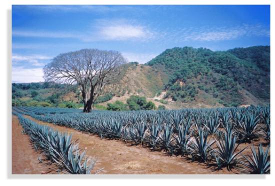
Tequila is made by distilling the juice of certain species of agave plants. Agaves are commonly called “century plants” in the USA, a name derived from the length of time they supposedly grow before producing a flowering stalk – actually, from eight to twenty years depending on the species, rather than the hundred suggested by their common name! Some species flower only once and die shortly afterwards, others can flower almost every year. Agaves are no relation botanically to cacti, even though they are often mistakenly associated with them. The ideal agave for tequila is the Agave tequilana Weber azul which has bluish-colored leaves.

Agave field in Jalisco

Agave field in Jalisco. Photo: Tony Burton

The tequila agaves are started from seed or from onion-size cuttings. When the plants are mature (about 10 years later), their branches are cut off, using a long-handled knife called a coa, leaving the cabeza (or “pineapple”), which is the part used for juice extraction. Cabezas (which weigh from 10 to 120 kilos) are cut in half, and then baked in stone furnaces or stainless steel autoclaves for one to three days to convert their starches into sugars.

From the ovens, the now golden-brown cabezas are shredded and placed in mills which extract the juices or mosto. The mixture is allowed to ferment for several days, then two distillations are performed to extract the almost colorless white or silver tequila. The spirit’s taste depends principally on the length of fermentation. Amber (reposado) tequila results from storage in ex-brandy or wine casks made of white oak for at least two months, while golden, aged (añejo) tequila is stored in casks for at least a year, and extra-aged (extra añejo) for at least three years.

Distillation: the Filipino Connection

Mexico’s indigenous Indians knew how to produce several different drinks from agave plants, but their techniques did not include distillation, and hence, strictly speaking, they did not produce tequila. Fermented agave juice or pulque may be the oldest alcoholic drink on the continent; it is referred to in an archival Olmec text which claims that it serves as a “delight for the gods and priests”. Pulque was fermented, but not distilled.

If the indigenous peoples didn’t have distilled agave drinks, then how, when and where did distillation of agave first occur? In 1897, Carl Lumholtz, the famous Norwegian ethnologist, who spent several years living with remote Indian tribes in Mexico, found that the Huichol Indians in eastern Nayarit distilled agave juice using simple stills, but with pots which seemed to be quite unlike anything Spanish or pre-Columbian in origin.

By 1944, Henry Bruman, a University of California geographer, had documented how Filipino seamen on the Manila Galleon had brought similar stills to western Mexico, for making coconut brandy, during the late sixteenth century.

Dr. Nyle Walton, of the University of Florida, expanded on Bruman’s work, showing how the Spanish authorities had sought to suppress Mexican liquor production because it threatened to compete with Spanish brandy. This suppression led to the establishment of illicit distilling in many remote areas including parts of Colima and Jalisco. Even today, the word “tuba”, which means “coconut wine” in the Filipino Tagalog language, is used in Jalisco for mezcal wine before it is distilled for tequila. This is probably because the first stills used for mezcal distillation were Filipino in origin.

“Appelacion Controlée”

Though colonial authorities tried to suppress illegal liquors, the industry of illicit distilling clearly thrived. One eighteenth century source lists more than 81 different mixtures, including some truly fearsome-sounding concoctions such as “cock’s eye”, “rabbit’s blood”, “bone-breaker” and “excommunication”! By the 1670s, the authorities saw the wisdom of taxing, rather than prohibiting, liquor production.

For centuries, distilled agave juice was known as mezcal or vino de mezcal “mezcal wine”). It is believed that the first foreigner to sample it was a Spanish medic, Gerónimo Hernández, in the year 1651. The original method for producing mezcal used clay ovens and pots.

By the end of the nineteenth century, as the railroads expanded, the reputation of Tequila spread further afield; this is when the vino de mezcal produced in Tequila became so popular that people began calling it simply “tequila”. When the Mexican Revolution began in 1910, it swept away a preference for everything European and brought nationally-made tequila to the fore. Tequila quickly became Mexico’s national drink. It gained prominence north of the border during the second world war, when the USA could no longer enjoy a guaranteed supply of European liquors.

To qualify as genuine tequila, the drink has to be made in the state of Jalisco or in certain specific areas of the states of Nayarit, Guanajuato, Michoacán and Tamaulipas. (We will take a closer look at this distribution in a future post).

The ideal growing conditions are found in semiarid areas where temperatures average about 20 degrees Centigrade, with little variation, and where rainfall averages 1000 mm/yr. In Jalisco, this means that areas at an elevation of about 1,500 meters above sea level are favored. Agaves prefer well-drained soils such as the permeable loams derived from the iron-rich volcanic rocks in Mexico’s Volcanic Axis.

Production of tequila has tripled within the last 15 years to about 250 million liters a year (2010). About 65% of this quantity is exported. Almost 80% of exports are to the USA, with most of the remainder destined for Canada and Europe.

Connoisseurs argue long and loud as to which is the better product, but all agree that the best of the best is made from 100% Agave tequilana Weber azul. I’m no connoisseur, but my personal favorite is Tequila Herradura, manufactured in Amatitán, a town between Tequila and Guadalajara. Anyone interested in the history of tequila will enjoy a visit to Herradura’s old hacienda “San José del Refugio” in Amatitán, where tequila has been made for well over a century. The factory is a working museum with mule-operated mills, and primitive distillation ovens, fueled by the bagasse of the maguey. The Great House is classic in style, with a wide entrance stairway and a first floor balustrade the full width of the building.

Visitors to the town of Tequila, with its National Tequila Museum, can  enter any one of several tequila factories to watch the processing and taste a sample. They can also admire one of the few public monuments to liquor anywhere in the world – a fountain which has water emerging from a stone bottle supported in an agave plant. “Tequila tourism” is growing in popularity. Special trains, such as “The Tequila Express” run on weekends from the nearby city of Guadalajara to Amatitán, and regular bus tours visit the growing areas and tequila distilleries. The town of Tequila holds an annual Tequila Fair during the first half of December to celebrate its famous beverage. Another good time to visit is on 24 July, National Tequila Day in the USA.

In 2006, UNESCO awarded World Heritage status to the agave landscape and old tequila-making facilities in Amatitán, Arenal and Tequila (Jalisco).

Related posts:

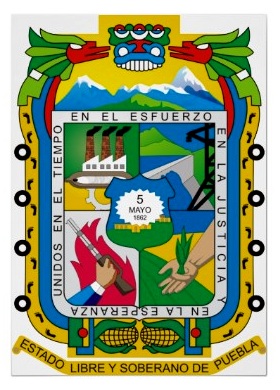
The important but often overlooked state of Puebla

 Other  Comments Off on The important but often overlooked state of Puebla
Dec 022011
 

The interesting and important state of Puebla is often overlooked because it is overshadowed by nearby Mexico City. In fact the western state border of Puebla is within 35 kilometers of the eastern edge of the Federal District. The state of Puebla also may be overlooked because it is rather small in area, ranking only 21st among Mexico’s 32 states. On the other hand, its 2010 population of nearly 5.8 million ranks it 5th behind only Mexico State, the Mexico City Federal District, Veracruz and Jalisco.

Though small in size, Puebla is very diverse. The topography is rugged and elevations range from under 100 meters in the northeast to volcanoes  rising over 5,000 meters above sea level, both to the east (Orizaba – 5,636m) and west (Popocatepetl – 5,410m and Iztaccihuatl – 5,230m). These extremes in elevation give Puebla a very wide range of climates and ecosystems, from semi-tropical rainforests and grasslands to highland forests and alpine ice packs.

Almost inevitably, given its high population density (168.5 inhabitants/square kilometer), many of these ecosystems have been degraded. Several of the most attractive natural areas are now protected. They include the Izta-Popo Zoquiapán, La Malinche and Pico de Orizaba National Parks as well as the very large Tehuacán-Cuicatlán Biosphere Reserve, which has over 100 different mammal species, 16 of which exist nowhere else on the planet.

Puebla also has significant social and ethnic diversity. There are numerous wealthy people and upscale areas in Puebla City, which has the eighth highest 2005 Human Development Index (HDI) score among major Mexican cities, behind only Mexico City, Chihuahua City, Monterrey, Querétaro City, Cancún, Torreón and Cuernavaca. Most people are surprised it comes out ahead of Guadalajara and Zapopan.

On the other hand, the state as a whole is rather poor. Based on its relatively poor levels of infant mortality, literacy, school enrollment, and income levels, the state ranks 28th of 32 states in terms of 2008 Human Development Index. Puebla is tied with Michoacán and ahead of only Chiapas, Guerrero and Oaxaca[1]. It also ranks 28th in illiteracy which is over 10% (2010); however 96% of the 6 to 11-year-olds now attend school, and illiteracy for those between the ages of 15 and 25 is less than 3%. While 98% of homes now have electricity, over half of Puebla’s workers make less than $115 pesos ($8.20US) a day. Approximately two/thirds of the state’s population live below the Mexican poverty line. The state’s high level of poverty is partially due to its indigenous population of almost one million and the fact that almost 30% of its inhabitants live in rural areas, some of them quite remote.

The city of Puebla is the heart of a Metropolitan Area which extends across state lines to the city of Tlaxcala. Metropolitan Puebla-Tlaxcala is the country’s 4th largest urban area with a population over 3.1 million, but is overshadowed by Mexico City, the eastern edge of which is less than 30 minutes by expressway. In fact, some urban specialists suggest that these two major metropolitan areas may merge in the future. On the other hand, the mighty Popocatepetl and Iztaccihuatl volcanoes, both over 5,000 meters in height, lie directly between the two cities. The high speed expressway skirts around the north side of the volcanoes.

The city of Puebla has long had strategic significance. The city was initially established during the colonial period owing to its strategic location between Mexico City and Veracruz, the dominant port for shipments to and from Spain. Puebla was the country’s second largest city for more than three centuries up until the mid 19th century. The Mexico City-Puebla railway was completed in 1869, but the main line to Veracruz bypassed the city, which diminished its comparative advantage, and resulted in it dropping to fourth place, overtaken by Guadalajara and Monterrey.

The state’s historical importance is evidenced by numerous important military confrontations, including the massacre of Cholula (1519), Santa Ana’s siege of Puebla City (1845), American General Winfield Scott’s occupation (1845-48), the “Cinco de Mayo” battle of Puebla against the French (1862), the French victory in the Second Battle of Puebla (1863), and occupation by the Zapatistas during the Mexican Revolution. The state is the birthplace of four Mexican Presidents: Ignacio Comonfort (1855–1858), Juan N. Méndez (1876–1877), Manuel Ávila Camacho (1940–1946) and Gustavo Díaz Ordaz (1964–1970).

Despite the state’s relative poverty, industrial development has been significant and Puebla has become one of Mexico’s most industrialized states. Since colonial times Puebla has been an important center for the textile and ceramic industries. Much of Mexico’s famous talavera pottery is made in Puebla. Talavera came to Puebla from Talavera, Spain, which in turn had acquired it from Arab traders who originally brought it from China.

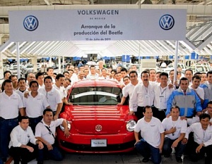
Since the mid 20th century Puebla has become a very important modern industrial area. The most important manufacturing activities are metals, chemicals, electronics, textiles and particularly motor vehicles. The Volkswagen plant in Puebla is one of the largest outside Germany. In July 2003 it produced the very last of the over 21 million old “Beetles” built by VW. The plant now produces New Beetles, Jettas and Boras that are exported worldwide. The motor vehicle assembly industry is supported by scores of automobile parts factories in the state.

Related articles:

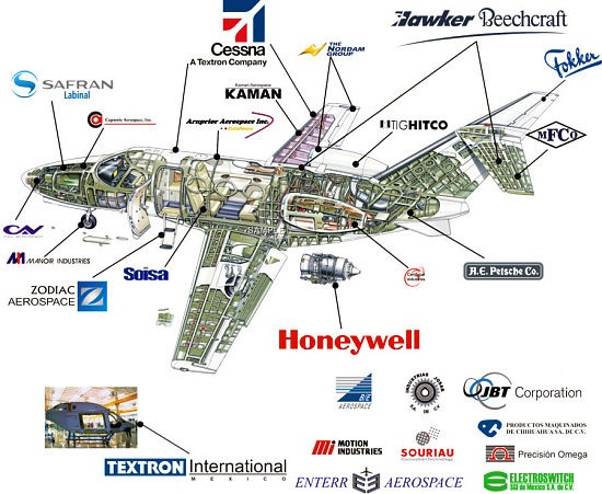
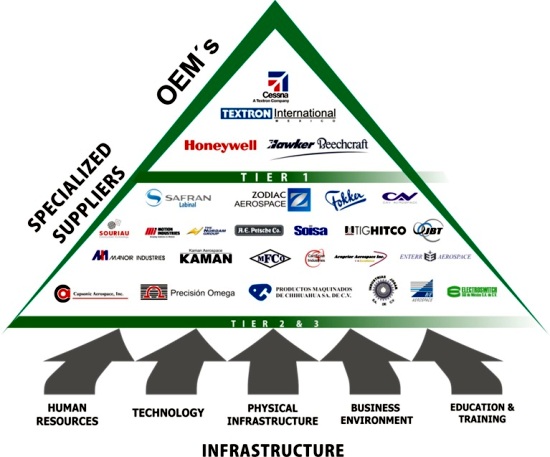
The reasons why Mexico is fast becoming a key player in aerospace manufacturing

 Updates to Geo-Mexico  Comments Off on The reasons why Mexico is fast becoming a key player in aerospace manufacturing
Sep 172011
 

In a previous post, we looked at why  Querétaro has become a hub of aerospace manufacturing, home to major manufacturing or research plants for such firms as Bombardier and GE.

In this post we take a further look at the aerospace industry in Mexico, which, according to ProMexico,  the Mexican federal agency that promotes trade and investment, has expanded at 17% a year since 2005. Mexico’s aerospace manufacturing, which began as a relatively simple assembly industry, has evolved today into sophisticated aero-parts and fuselage manufacturing, well supported by specialist education and training programs. In the next phase, Mexico is expected to acquire full service airplane assembly meeting all relevant international design and innovation requirements.

Aerospace parts

The shift in aerospace from simple assembly to complex design, manufacturing and research, echoes what has already happened in some other sectors, such as vehicle manufacture.

Today, the aerospace industry employs 32,000 people in 16 Mexican states. the four most important states for the aerospace industry in Mexico are Baja California, Querétaro, Nuevo León and Chihuahua.

Approximately half the jobs in the sector are located in Baja California, mainly in either Tijuana or Mexicali. The first two aerospace companies to locate in Baja California (in the mid 1960s) were Rockwell Collins and Switch Luz. Today, aerospace firms in Baja California make electronic components, air conditioning systems, cable harnesses, hoses and seals, rustless steel bolts, turbine connector assemblies and blankets for commercial and military aircraft. Honeywell International has been influential in developing aerospace in Baja California since 2007, when it opened a testing facility in Mexicali.

How important is the aerospace sector in Mexico?

  • The number of aerospace manufacturing companies in Mexico is expected to grow from 232 in 2010 to more than 350 in 2015.
  • The aerospace sector is expected to provide 37,000 direct jobs in 2015, 28% more than in 2010
  • Exports of aerospace parts were worth $3.1 billion in 2010, a figure expected to jump to $5.7 billion by 2015.

Aerospace firms

The major factors that have helped Mexico set up and develop aerospace manufacturing are:

  • Mexico has the second largest fleet of private aircraft in the world after the USA,
  • Since 2009, it has become one of the world’s largest recipients of aerospace foreign direct investment
  • Mexican firms meet technical requirements and delivery schedules
  • Mexico offers easy access to raw materials for all phases of production
  • The Mexican market is economically, socially and politically stable
  • The government has offered strong support for the aerospace industry in Mexico. Import duties on aeronautics components were abolished in Mexico in 2007, the same year that Mexico and the USA signed a Bilateral Aviation Safety Agreement to facilitate cross-border aviation-related trade and services
  • Several Mexican states, especially those along the northern border have a well-established industrial infrastructure
  • The proximity of Baja California to the established aerospace industry and important aerospace markets in California, has been an important stimulus to aerospace firms in that state
  • Overall, Mexico offers lower production costs
  • Labor costs are not as cheap as India and China, but that is more than compensated by reduced transport costs. Aerospace parts made in Mexico can reach an assembly plant in the USA in 16 hours by road, compared to about 21 days from China by sea.
  • There is a large pool in Mexico of skilled labor, trained for electronics and auto-parts manufacturing.
  • Mexico’s workers are well educated, with sound engineering and technical skills

The available evidence suggests that there are now more engineering courses and graduates in Mexico each year than in the USA. The number of engineering graduates in the USA has not risen in recent years, and the number of engineering courses has actually declined. In Mexico, the numbers of engineering courses and graduates have both continued to grow at a very rapid rate. Specialist courses are already training students for the aerospace industry. For example the private university CETYS,  with campuses in Tijuana and Mexicali, has added aerospace to its graduate and undergraduate curricula and also offers a Master’s in Aerospace Engineering. Undergraduate programs in aerospace have been introduced at two public universities: the Autonomous University of Baja California and the Tijuana Technological Institute. The Tijuana Technological University has started to train technicians in assembling harnesses for the aerospace industry, modeled on a curriculum developed for a technical school in Toulouse, France (the home of Airbus).

Upcoming trade event:

Mexico is hosting an Aerospace Summit in the city of Chihuahua, October 18-20, 2011, in the Chihuahua Convention Center. (Graphics used above come from the trade event site.)

Sources include:

The reasons why Mexico has become one of the world’s top ten vehicle-making countries

 Other  Comments Off on The reasons why Mexico has become one of the world’s top ten vehicle-making countries
Sep 052011
 

As we saw in an earlier post – Where are Mexico’s vehicle assembly plants located? – Mexico’s autoparts and vehicle assembly industry plays a vital role in Mexico’s economy, attracting foreign direct investment (FDI), providing employment and bringing in billions of dollars in export earnings each year.

vw-plant-mexico

Mexico also has a large internal (domestic) market for vehicles. According to the Mexican Automotive Distributors’ Association, 820,000 vehicles were sold on the national market in 2010. The market leader is Nissan (with 23.5% of the domestic market), followed by General Motors (19.5%) and Volkswagen (13.2%). Mexico’s best-selling cars are the Nissan Tsuru/V16 and the Volkswagen Jetta. Nissan aims to have domestic suppliers for 90% of all its components by the end of 2011.

Why has Mexico become one of the world’s top ten vehicle-making countries?

  • Mexico already had a highly competitive manufacturing sector
  • Mexico has an excellent communications network, with several trans-border highways and rail lines, as well as several major ports. This means lower shipping costs
  • Stable exchange rate
  • Significant domestic market (population 112 million)
  • Mexico has formed an outstanding network of trade and investment agreements. Mexico has the world’s largest free trade agreements network, spanning three continents, and offers preferential tariffs to more than 44 countries.
  • Competitive labor costs
  • Responsible federal fiscal policies have increased the resilience of the national economy
  • Availability of skilled labor and well-educated, multilingual managers
  • Proximity to the USA, both for investments and for markets
  • Lower production costs: since 2009, the manufacturing costs for vehicles in Mexico has been between 80% and 90% of the equivalent cost in the USA.
  • Total production and delivery costs: For vehicles sold in the USA, costs are lower for vehicles made in Mexico than for those made anywhere else, including China, India and Brazil.
  • Government support: To stimulate higher-value activities (engineering, design, testing, R&D), Mexico’s government offers numerous incentives, including job training and tax credits.

Vehicles made in Mexico are high quality
Mexican manufacturing plants have consistently done well in the annual quality surveys undertaken by market research firm JD Power and Associates. The study has been conducted annually for the past 17 years and provides an important benchmark for the automotive sector. Vehicles made in Mexico usually have fewer defects than those made in the USA. In 2008, the Toyota plant in Baja California won the award for the top ranking plant in the Americas.

The top ten manufacturers:

According to the latest figures from the International Organization of Motor Vehicle Manufacturers (OICA), Mexico was the world’s 9 th largest vehicle-maker (2.2 million vehicles) in 2010, behind China, Japan, USA, Germany, South Korea, Brazil, India and Spain, but ahead of France, Canada, UK, Italy and Russia.

Further information:

For more facts and figures (with graphs and maps useful for teaching purposes): Mexico and the Automotive Industry, a strategic place to invest. Gerardo Ruiz Mateos, Ministry of Economy. June 2010. (pdf file)

Where are Mexico’s vehicle assembly plants located?

 Teaching ideas  Comments Off on Where are Mexico’s vehicle assembly plants located?
Aug 272011
 

Mexico is one of the world’s “Top Ten” countries for vehicle production and for vehicle exports. 75% of Mexico’s annual production of around 2 million vehicles are made for export. The industry attracts large amounts of Foreign Direct Investment (FDI). Vehicle assembly plants provide around 60,000 jobs, with a further 80,000 employed in distributorships nationwide and a whopping 420,000 employed in the autoparts sector. The combined exports of vehicles and autoparts bring 85 billion dollars a year into the Mexican economy.

There are more than 25 vehicle assembly plants in Mexico, manufacturing many brands of cars and trucks (see map). In addition, there are 1100 firms specializing in making parts for vehicles. In this post, we consider the location of vehicle assembly plants; in a later post we will look more closely at the characteristics of the vehicle assembly and autoparts industry in Mexico.

Vehicle assembly plants in Mexico, 2011

Vehicle assembly plants in Mexico, 2011. Credit: Tony Burton/Geo-Mexico; all rights reserved.

As the map shows, certain areas of Mexico have attracted more investment in vehicle assembly plants than other areas. The two largest existing concentrations are focused on Toluca in the State of México, and on Saltillo in northern Mexico. However, the fastest growing cluster is in the central state of Guanajuato, where two major plants are currently in the planning stages.

  • 1. What are the advantages and disadvantages of having several vehicle assembly plants in the same area?
  • 2. What the advantages and disadvantages of locating vehicle assembly plants far apart?
  • 3. Vertical linkages occur when one company controls many or all stages in the production of a product. For instance, an auto company may make its own engines and accessories to attach to the vehicles it makes. Horizontal linkages exist where one company is supplied with the components (engines, gearboxes) it needs by another company. What part do you think vertical and horizontal linkages might play when a major automaker decides where to locate a new vehicle assembly plant?
  • 4. Why are there no vehicle assembly plants in southern or eastern Mexico?
  • 5. What are the main reasons for the cluster of vehicle assembly plants near Mexico City and Toluca?
  • 6. Why has Ford chosen to locate its two plants in northern Mexico in different states?

Discuss your suggestions with your classmates and teacher. The answers to these questions should give you a useful list of the major factors that explain the distribution of vehicle assembly plants in any country, not just Mexico.

Related post:

A case study of clustering in a different industry

Car-makers building new assembly plants in Mexico

 Mexico's geography in the Press  Comments Off on Car-makers building new assembly plants in Mexico
Aug 232011
 

Two major Japanese car-makers—Mazda and Honda—have announced expansion plans in Mexico in recent months. They will help ensure that Mexico remains the 9th largest car manufacturer in the world, and the 6th largest vehicle exporter. In addition, Italian auto-maker Fiat is expanding its plant in Toluca.

Mazda plant in Salamanca

Mazda is building a new 500-million-dollar plant in Salamanca (Guanajuato) to assemble its best-selling Mazda2 and Mazda3 models. The Mazda3 is the Mazda’s top selling model in the USA. The Mazda plant, scheduled to open in 2013, will employ about 3,000 workers and produce 140,000 vehicles a year.

Honda plants in El Salto and Celaya

Honda, which currently has two manufacturing plants in El Salto (Jalisco), is to construct a third plant, in Celaya (Guanajuato). The new plant will produce the fuel-efficient Honda “Fit” for the North American market. Due to open in 2014, it represents an investment of 800 million dollars and will have the capacity to assemble 200,000 vehicles a year.

Mexican-made cars being exported to China

By early next year, Fiat will be producing 100,000 units a year of its model 500 at its new plant in Toluca, in the state of Mexico. Only 3.5% of these units will be sold in the domestic market. The remainder are destined for export markets, including China, Brazil and the USA. China has already received its first shipment of 100 exclusive “First Edition” vehicles and is expected to take 50,000 a year once the Fiat plant is operating at full capacity.

Related posts:

Mexico’s economic geography is analyzed in chapters 14–20 of Geo-Mexico: the geography and dynamics of modern Mexico. Buy your copy of this invaluable reference guide today!
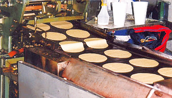
Jul 092010
 

The 4th Assessment Report (2007) of the IPCC (Intergovernmental Panel on Climate Change) involved the contributions of 2,500 scientists from 130 countries. The number of Mexican scientists participating was higher than the number from many richer countries including Spain and France. Sixteen Mexican scientists were involved in writing the 4th IPCC report. Ten of the sixteen hold positions at UNAM (the National University in Mexico City), making UNAM one of the institutions in the world with the highest rate of participation.

The 16 Mexican contributors were:
IPCC 4th Report

A further 8 Mexican scientists helped edit the documents:

Many of the same scientists have now been confirmed as members of the international team developing the 5th Assessment Report of the IPCC. In addition, the following newcomers have also been appointed:

  • Salvador Lluch-Cota, Centro de Investigaciones Biológicas del Noroeste, S.C. (Lead author, Ocean systems)
  • Fernando Aragon, El Colegio de la Frontera Sur (Urban areas)
  • Ursula Oswald-Spring, Centro Regional de Investigaciones Multidiscipinarias, UNAM    (Human security)
  • Roberto A. Sanchez Rodriguez, University of California, Riverside  (Adaptation planning and implementation)
  • Edgar Ortiz (Integrated Risk and Uncertainty Assessment of Climate Change Response Policies)
  • Martha Micheline Cariño Olvera (Social, Economic and Ethical Concepts and Methods)
  • Mauricio de María Campos (Sustainable development and equity)
  • Angel de la Vega     (Energy systems)
  • Xochitl Cruz-Nuñez (Transport)
  • Omar Masera (Agriculture, Forestry and other land uses)
  • Gian Carlo Delgado (Human Settlements, Infrastructure and Spatial Planning)
  • Alba Eritrea Gámez Vázquez (Regional Development and Cooperation)
  • Manuel Angeles (National and Sub-National Policies and Institutions)
  • Tomás Hernández-Tejeda, National Institute of Research in Forestry, Agriculture and Livestock (INIFAP)/SAGARPA (Synthesis Report)

Mexico’s diverse climates are the subject of chapter 4 of Geo-Mexico: the geography and dynamics of modern Mexico. Water availability, rivers, aquifers, water issues and hazards are analyzed in chapters 6 and 7. Buy your copy today!
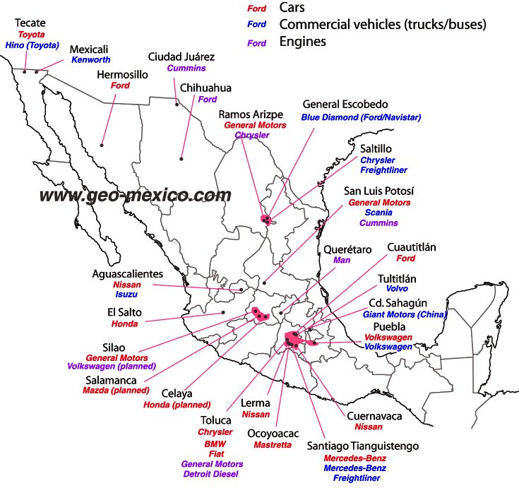
Privacy Policy


Your privacy is very important to us.

This Policy is for the web site of Geo-Mexico https://www.geo-mexico.com, a site, located in BC, Canada, supporting the book Geo-Mexico: the geography and dynamics of modern Mexico (Sombrero Books 2010), written by Dr. Richard Rhoda and Tony Burton. This Policy was last updated on June 25, 2022.

To that end, here is our Policy and Practice regarding your personal information.

We can be reached via e-mail at Geo-Mexico for general communications, or to resolve a particular problem or information request.

Use of cookies

A cookie is a small amount of data that is sent to your browser from a Web server and stored on your computer’s hard drive. We use cookies in a limited way to help deliver advertisements, to identify unique browsers that visit us and to track usage throughout our site. We also use cookies on our site to make the log-in and sign-up processes more convenient for users.

We do not link the information we store in cookies to any personally identifiable information you submit while on our site.

We use Google Analytics for aggregated, anonymized website traffic analysis. In order to track your session usage, Google drops a cookie (_ga) with a randomly-generated ClientID in your browser. This ID is anonymized and contains no identifiable information like email, phone number, name, etc. We also send Google your IP Address. We use GA to track aggregated website behavior, such as what pages you looked at, for how long, and so on. This information is important to us for improving the user experience and determining site effectiveness. If you would like to access what browsing information we have – or ask us to delete any GA data – please delete your _ga cookies, reach out to us via this form, and/or install the Google Analytics Opt-Out Browser Add-On.

We use third-party advertising companies to serve ads when you visit our website. These companies may use information (not including your name, address, email address, or telephone number) about your visits to this and other websites in order to provide advertisements about goods and services of interest to you. If you would like more information about this practice and to know your choices about not having this information used by these companies, click here.

Amazon Affiliate Disclosure

As an Amazon Associate Geo-Mexico earns from qualifying purchases.

Uses of Information Collected

What information do we collect?

For each visitor to our URL, where possible, our Web server automatically recognizes only your ISP’s domain name, but not your e-mail address.

We collect only the domain name, but not the e-mail address of visitors to our Web site.

We do collect the e-mail addresses of those who:

  • * post messages or comments on the site;
  • * communicate with us via e-mail;
  • * purchase books directly from us via our site;
  • * register at our site;
  • We do aggregate information on which pages consumers in general access or visit, and information volunteered by the consumer, such as survey information and/or site registrations.
  • We use third-party advertising companies to serve ads when you visit our web site. These companies may use information (not including your name, address email address or telephone number) about your visits to this and other web sites in order to provide advertisements about goods and services of interest to you.

Uses of information collected.

What we do with the email addresses we do collect:

  • The information we collect is used by us, and only us, to contact consumers for communication purposes and is not shared with or sold to other organizations.
  • If you supply us with your postal address on-line, you will only receive the information for which you provided us your address.
  • Sombrero Books does not use agents or service providers on the site.
  • Sombrero Books does not share, sell, rent or trade Personal Information with third parties for their promotional purposes.

We reserve the right to disclose your personally identifiable information as required by law and when we believe that disclosure is necessary to protect our rights and/or comply with a judicial proceeding, court order, or legal process served on our Web site.

Updating, Accessing, Amending or Correcting Personally identifiable information.

If your personally identifiable information changes, or if you no longer desire our service, you may correct, update, amend, delete/remove or deactivate it by emailing Customer Support.

Site Security Measures

We follow generally accepted industry standards to protect the personally identifiable information submitted to us, both during transmission and once we receive it. No method of transmission over the Internet, or method of electronic storage, is 100% secure, however. Therefore, while we strive to use commercially acceptable means to protect your personal information, we cannot guarantee its absolute security.

If you have any questions about security on our Web site, you can send an email.

Third party websites

This privacy statement does not apply to third party websites connected by links on our website. We cannot guarantee that these third parties handle your personal data in a reliable or secure manner. We recommend you read the privacy statements of these websites prior to making use of these websites.

Changes to this Privacy Statement

We reserve the right to modify this privacy statement at any time, so please review it frequently. If we decide to change our privacy policy, we will post those changes to this privacy statement, and other places we deem appropriate so that you are aware of what information we collect, how we use it, and under what circumstances, if any, we disclose it.