admin

Mar 192017
 

Twice a year, at the spring and fall equinox, the sun is positioned directly over the equator, giving everywhere on the planet twelve hours day and twelve hours night. The spring or vernal equinox, which heralds the start of spring, usually falls on 20 March or 21 March, and is celebrated in many parts of the world as a time of fertility and rebirth.

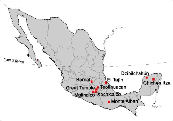
Mexico is no exception, and here are the nine most magical places in Mexico to celebrate the spring equinox:

Nine Best Places for Spring Equinox

Nine Best Places in Mexico to witness the Spring Equinox

1. Chichen Itza, Yucatán

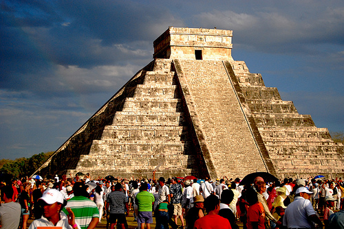
The Mayan archaeological site of Chichen Itza, between Mérida and Cancún, is a very popular place to witness the spring equinox. The Kulkulkan temple is a masterpiece, built according to precise astronomical specifications. At the equinoxes, the sun=s rays in the late afternoon dance like a slithering snake down the steps of the pyramid. Spectators may not realize that this pyramid has amazing acoustical properties as well:

The astronomical observatory known as El Caracol (“The Snail”) at Chichen Itza has features aligned so precisely that they helped the Maya determine the precise dates of the two annual equinoxes.

Serpent slithers down the steps of Kulkulcan pyramid, Chichen itza. Credit: Flickr:

Chichen Itza: serpent slithers down the steps of Kulkulkan pyramid,
Credit: Flickr: wowitsstephen

2. Dzibilchaltún, Yucatán

Dzibilchaltún, in the state of Yucatán, about 20 km from Mérida, is much less well known but equally fascinating. The rays of the rising sun (spectators arrive before 5 am) light up the windows and entrances of the Temple of the Seven Dolls in a spectacular display.

3. Great Temple, Mexico City

The Great Temple (Templo Mayor) in Mexico City marks the spot where legend says the Mexica priest Tenoch saw the promised sign of an eagle on a cactus indicating the original site for the Aztec capital of Tenochtitlan. The city was renamed Mexico City when the Spanish conquistadors defeated the Aztecs and eventually became the largest city in the western hemisphere. As the sun rises at the Equinox, its rays shine precisely between the two major temples at this historic site. This spectacle, probably once reserved for the priests, can now be enjoyed by all.

4. Teotihuacan, State of México

Teotihuacan (“the city of the gods”) is the single most visited archaeological site in Mexico and an outstanding location to witness the spring equinox. Within easy day trip range of Mexico City, Teotihuacan was once a bustling city housing an estimated 200,000 people. It holds a special place in Mexico’s archaeological history since it was the first major site to be restored and opened to the public ~ in 1910, in time to celebrate the centenary of Father Miguel Hidalgo’s call for Independence.

The original inhabitants erected marker stones on nearby hillsides to mark the position of the rising sun at the spring equinox as viewed from the Pyramid of the Sun. Many of the visitors at the spring equinox today dress in white and climb to the top of the Pyramid of the Sun in order to receive the special energy of the equinox. There is some concern about the problems that so many spring revelers may cause:

5. Malinalco, State of Mexico

There is no direct evidence that the ancients celebrated the equinox at this location, though the archaeological site certainly has a carefully determined orientation. However, perhaps on account of its accessibility from Mexico City, Malinalco, in the State of México, has become a popular place to see in the spring.

6. Xochicalco, Morelos

Xochicalco, in the state of Morelos, is equally easy to reach from Mexico City and was the site of a very important calendar-related conference in the 8th century BC. It attracts equnox viewers on account of its considerable astronomical significance from pre-Hispanic times.

The sites main claim to archeo-astronomy fame is not connected to the equinoxes but to the two days when the sun is at its zenith (directly overhead) here each year, on 15 May and 28 July. The vertical north side of a 5‑meter‑long vertical “chimney” down into one particular underground cave ensures that the sunlight entering the cave on the day of the zenith is precisely vertical. The south side of the chimney slopes at an angle of 4o23′. Sunlight is exactly parallel to this side on June 21, the day of the Summer solstice.

7. Bernal, Querétaro

At the Spring Equinox, this town is invaded by visitors “dressed in long, white robes or gowns, and red neckerchiefs” who come seeking “wisdom, unity, energy and new beginnings”. (Loretta Scott Miller, in El Ojo del Lago, July 1997).

Since 1992, this Magic Town has held events each year from 19 to 21 March to celebrate the Spring Equinox. On 20 March, hundreds of people hike in the evening to the chapel of Santa Cruz, part-way up the Peña de Bernal, the giant monolith that overshadows the town, for hymns and prayers. They greet the sun as it rises on 21 March. Following a ceremony in the town square at noon (21 March), as many as 15,000 visitors form a human chain stretching from the plaza to the top of the monolith. Local attractions in Bernal include small museums about local history, masks and Mexico’s movie industry.

8. El Tajín, Veracruz

The amazing Pyramid of the Niches in El Tajín, Veracruz, is another great place to visit on the spring equinox. Crowds gather here to celebrate the equinox, despite the fact that in this location, there is no particular solar spectacle to observe. Today’s celebrations continue an age-old tradition at El Tajín, which has long been one of the most important ceremonial centers in this region.

9. Monte Alban, Oaxaca

Monte Alban, just outside the city of Oaxaca, was the first planned urban center in the Americas, and was occupied continually for more than 1300 years, between 500 BC and AD 850. Visitors from all over the world, many of them dressed in white, converge on Monte Alban at the spring equinox to recharge their energy levels.

Magical Mexico!
Mexico and Ireland: a lasting relationship forged by potatoes. Happy St. Patrick’s Day!

 Other  Comments Off on Mexico and Ireland: a lasting relationship forged by potatoes. Happy St. Patrick’s Day!
Mar 152017
 

In honor of St. Patrick’s Day, we offer this short list of references highlighting some of the more significant connections between Ireland and Mexico.

Séamus Ó Fógartaigh in his “Ireland and Mexico“, published in Irish Migration Studies in Latin America by the Society for Irish Latin American Studies (based, curiously, in Switzerland) looks at the early links between Ireland and Mexico, including suggestions that the travels of St. Brendan the Navigator may have inspired Christopher Columbus and that the famous “Plumed Serpent” of Mexican mythology may have originated from the deification of an Irish monk.

Much better known are the later links. During colonial times, several of the Spanish administrators sent to New Spain (now Mexico) were direct descents of Irish exiles to Spain. They include the 63rd and last Spanish Viceroy of New Spain Juan O’Donojú (formerly O’Donoghue) who arrived in the New World shortly before Mexico became Independent in 1821.

A generation later, Irish soldiers who chose to leave (deserted) the US army formed the backbone of Mexico’s St. Patrick’s Battalion (Batallón San Patricio) which fought the invading Americans in 1846-48. They are especially remembered for their bravery in the Battle of Churubusco (in Mexico City) in 1847. Their story is well remembered by Mexicans today, their exploits commemorated every year at a ceremony in Mexico City, and the basis of several books and the movie One Man’s Hero. The single, best account is that by Michael Hogan in The Irish Soldiers of Mexico. For a summary account, try “The St. Patricio Battalion, The Irish Soldiers of Mexico” by Jaime Fogarty, published in UNAM’s Voices of Mexico magazine, April-June, 2000.

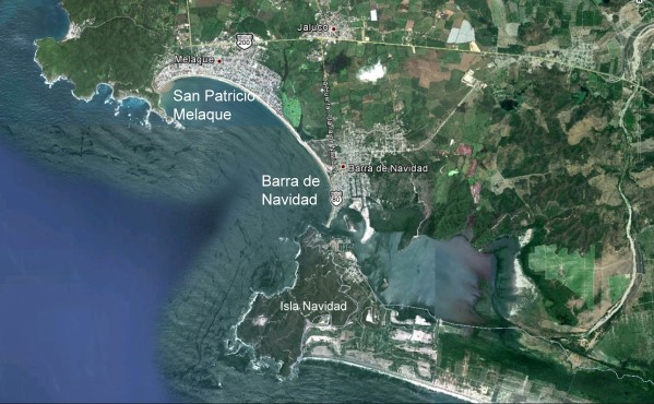
San Patricio Melaque (Google Earth)

San Patricio Melaque (Google Earth)

On the Jalisco coast, the small town of San Patricio Melaque (around the bay from Barra de Navidad and the Isla de Navidad tourist development) holds an annual fiesta that celebrates both the town’s patron saint and the achievements of the Irish soldiers. Nine days of activity (church services, fireworks, parades, bullfights, fairground games) come to a climax on 17 March. (It is sometimes claimed that San Patricio Melaque is the only settlement named San Patricio in Mexico, but that is not quite true, since there are at least three others: two tiny hamlets called San Patricio, relatively close to Cd. Victoria in Tamaulipas, and one named San Patricio de la Mesa in the mountains east of Hermosillo in Sonora.)

In the twentieth century, Álvaro Obregón (family name O’Brien) was President of Mexico from 1920 to 1924. (We will take a critical look at his relationship with the indigenous Yaqui Indians of Sonora in a later post). The city of Ciudad Obregón in Sonora is named in his honor. Artists of Irish descent also impacted Mexico’s national life. They included architect, painter and muralist Juan O’Gorman (1905-1982), responsible for the monumental mosaic that adorns the walls of the National University (UNAM) Library in Mexico City, and a striking, colorful mural in Pátzcuaro that depicts an erupting volcano; this mural was completed just one year before the unexpected eruption nearby of Paricutín Volcano.

Today, according to Wikipedia, there are between 300,000 and 600,000 people of Irish descent living in Mexico, mostly in either northern Mexico or Mexico City.

Dr. Michael Hogan has done far more than most to publicize the links between Ireland and Mexico.

Most of the links we’ve described might never have happened if Mexico had not sent an unwanted export to Ireland in the middle of the nineteenth century. The census of 1841 in Ireland recorded a population of about 8 million. The staple Irish food at that time was the humble potato and Ireland’s rapid population growth during the early part of the nineteenth century was based on the so-called “potato economy”.  Ireland was bursting at the seams in 1841, but just a decade later, after the potato famine, the population had fallen to 6.5 million. The cause of the Irish potato famine was a water mold (Phytophthora infestans) that originated in Mexico and crossed the Atlantic in the 1840s, reaching Europe in 1845 before rapidly spreading across the continent to reach Ireland.

If a Mexican water mold had not provoked the Irish potato famine, maybe there would have been no settlements named San Patricio in Mexico today, and no cause to celebrate St. Patrick’s Day in Mexico! Wherever you may be, have a very Happy St. Patrick’s Day!
Related links:

Geography, residence patterns and architecture in the mining town of Santa Rosalía, Baja California Sur

 Other  Comments Off on Geography, residence patterns and architecture in the mining town of Santa Rosalía, Baja California Sur
Mar 092017
 

In a previous post — The re-opening of the giant El Boleo copper mine in Santa Rosalía, Baja California Sur —  we looked at the repeated boom-bust-boom history of the copper mining center of Santa Rosalía on the Baja California Peninsula. The arid peninsula did not offer much in the way of local resources for the construction of a mining settlement. When mining took off, an entire town was needed, virtually overnight. Almost all the materials necessary for the construction and exploitation of the mines and for building the houses and public buildings had to be imported, primarily from the USA.

As the town grew at the end of the nineteenth century, a clear geographic (spatial) segregation developed, which is still noticeable even today:

  • Workers’ homes were built on the lowland near the foundry and port
  • Higher up the slope was the Mexican quarter where government workers and ancillary support staff lived
  • The highest section of town, overlooking everything, was the French quarter.

The contrasts of Santa Rosalía at this time were well summed by María Eugenia B. de Novelo:

“Santa Rosalía was a place of clashing contrasts and situations. It had a scarred backdrop of copper hills, a black-tinted shore, French silks, fine perfumes, crystal, Bordeaux wines and Duret cooking oil, sharing the scene with flour tortillas, giant lobsters, abalone and chimney dust.”

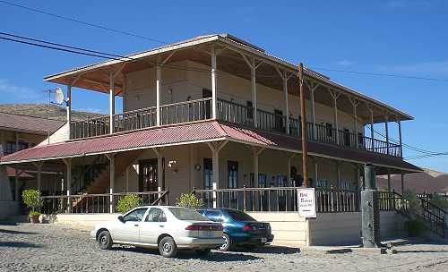
The French quarter has retained its distinctive architecture to the present day. At one end is the Hotel Francés, opened in 1886, which has an incredibly stylish period interior and still operates today.

Hotel Francés, Santa Rosalía

Hotel Francés, Santa Rosalía. Photo: Tony Burton

The gorgeous architecture of many of the homes of the French quarter is reminiscent of New Orleans. Beautiful wooden houses stand aloof on blocks with porches, balconies and verandas, competing for the best view over the town below. Wooden homes are decidedly unusual in this part of Mexico, which was never forested, and are, indeed, rare almost everywhere in the country. There are so many wooden homes here that Santa Rosalía has long had its own fire department, just in case!

At the other end of the French quarter are the former mining offices, now the Museo Boléo, an interesting museum where interior details are little changed from a century ago. Standing in the main hall, it is possible to imagine the hustle and bustle of former days, as clerks work feverishly to keep up with their superiors’ numerous demands. The mining company attracted workers from far afield. Three thousand Chinese workers arrived, settling the districts still known as La Chinita and Nuevo Pekin.

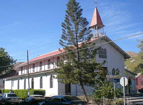
The most conspicuous landmark in the main part of town remains the former foundry, no longer open to the public. The next most conspicuous landmark is the church of Santa Bárbara. There are serious doubts as to who designed this unusual church, assembled out of pre-fabricated, stamped steel sheets or plates. Most guidebooks attribute the church to Gustave Eiffel, the famous French architect responsible for the Eiffel Town in Paris. According to this version, Eiffel’s design won a prize at the 1889 Universal Exposition of Paris, France, and was originally destined for somewhere in Africa. It was later discovered in Belgium by an official of the Boleo mining company, who purchased it and brought it back to Santa Rosalía in 1897.

The church of Santa Rosalía

The church of Santa Rosalía. Photo: Tony Burton.

The latter part of the story may be correct, but research by Angela Gardner (see Fagrell, 1995) strongly suggests that the original designer was probably not Eiffel but is far more likely to have been a Brazilian, Bibiano Duclos, who graduated from the same academy as Eiffel in Paris. Duclos took out a patent on pre-fabricated buildings, whereas there is no evidence that Eiffel ever designed a pre-fabricated building of any kind. Whoever designed it, it is certainly a unique design in the context of Mexico, and well worth seeing.

Other well-preserved buildings dating back to the heyday of the town’s success include the municipal palace or town hall (formerly a school designed by Gustave Eiffel), the Central Hotel, the DIF building, the Club Mutualista, the Post Office and the Mahatma Gandhi library, currently being restored. The library is in Parque Morelos, which is also the last resting place for a Baldwin locomotive dating back to 1886.

If walking around town looking at the architecture makes you hungry, try the French pastries (and Mexican sweet breads) from the Panadería El Boleo on the main street. With slight hyperbole, Panadería El Boleo boasts on its wall of being the World’s most famous bakery. Expect to queue, but enjoy the smells of fresh baked goods while you wait.

The distinctive history, architecture (and pastries) of Santa Rosalía, assuming they are conserved, should prove in the future to be an excellent basis for the development of cultural tourism to supplement the ecotourism and adventure tourism already in place.

Sources:

Want to read more?

Note : This post was first published 11 October 2011.

No wall necessary: the USA-Mexico border at Nogales in 1915

 Other  Comments Off on No wall necessary: the USA-Mexico border at Nogales in 1915
Feb 232017
 

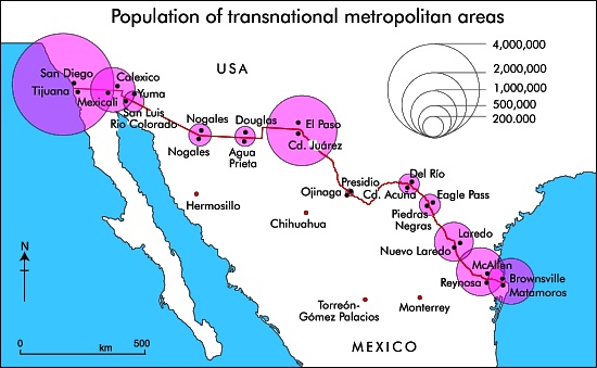
There are almost fifty places where people can legally cross the Mexico–United States border, but only one where the cities on either side of the border have the same name: Nogales.

transnational-metropolitan-areas

The fascinating history of the two Nogales (Ambos Nogales), twin cities on either side of the border, is related in this detailed 2010 blog post by Robert Lucas: Ambos Nogales Face Across the Border.

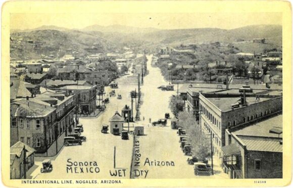
The geographic curiosities of the border between Nogales (Sonora) and Nogales (Arizona) included, historically, a street that ran east-west along the border, with one half of the street in Mexico and the other half in the USA:

Postcard of Ambos Nogales, ca 1915

Postcard of Ambos Nogales, ca 1915

This postcard from about one hundred years ago shows International Avenue, Nogales. The boundary line on the postcard was added by the publisher to indicate that the border ran down the middle of the street. Even in the absence of any boundary fence, residents were apparently still required to cross at one of two entry points: either the Morley Avenue crossing (shown in the postcard) or the Grand Avenue crossing further to the west.

Prior to the building of the International Avenue, which created a clear separation between Mexico and the USA, there had been some interesting consequences of having a bi-national city straddling the international border. For example, after Arizona introduced prohibition, outlawing the production and sale of alcohol in that state, some publicans took advantage of the unusual geography of Nogales to build saloons that straddled the border. Patrons tired of sipping their tea who wanted to enjoy duty-free mescal could simply move to the south end of the bar…

In 1897, the U.S. Congress ordered that a 60-foot strip along the border in downtown Nogales be cleared of all structures as a measure to suppress customs fraud. Mexico soon followed suit, creating the International Avenue. The International Avenue did not look like the view in the postcard for for very long. By 1916, a temporary fence had been erected down the middle.

Two years later, on 27 August 1918, this area was the scene of the Battle of Ambos Nogales (La batalla del 27 de agosto), which led to a permanent fence being built, forever separating Ambos Nogales into two distinct cities.

Related posts:

The world’s largest crystals and strange microbes grow in caves in Chihuahua, Mexico

 Excerpts from Geo-Mexico, Updates to Geo-Mexico  Comments Off on The world’s largest crystals and strange microbes grow in caves in Chihuahua, Mexico
Feb 182017
 

The Naica caves, in the northern state of Chihuahua are home to the world’s largest natural crystals. The crystals are selenite, said to enhance sex drive.

The formation of the crystals caves is described in more detail below, but in February 2017, Penelope Boston, head of Nasa’s Astrobiology Institute announced that “bizarre and ancient microbes” had been found in these caves. The discovery came after nine years of work and was first announced at the American Association for the Advancement of Science conference in Boston. The life forms in the Naica caves survive by living on minerals such as iron and manganese and could be 50,000 years old. The find is still subject to peer-review and independent confirmation:

How were the crystals discovered?

Early in 2001, news emerged of a truly extraordinary discovery in caverns deep under the earth in the state of Chihuahua. Miners tunneling through the Naica Hills, south of Chihuahua City, in search of silver and zinc, found huge mineral crystals, far larger than any natural crystals previously seen anywhere else on the planet.

The monster crystals, over six meters long, are made of selenite, a crystalline form of the mineral gypsum (the number one ingredient in blackboard chalk!). For its pale translucence, this form of gypsum is known as selenite, named after Selene, the Greek goddess of the moon.

The largest crystals are over 11 meters long, and weigh more than 55 tons. Scientists believe they have found DNA from ancient bacterial life trapped in air bubbles inside the crystals.

The crystals formed when the caverns were completely filled with hot water (warmer than 50 degrees C) supersaturated with calcium sulphate (gypsum) for very long periods of time. The estimated growth rate, confirmed by uranium-thorium dating, is 1.5 mm per 1000 years, which means that the longest crystals took more than 500,000 years to form.

The engineer working for the mining company Peñoles that first reported these caves believes that many more caves probably exist, but stresses that they would never have been located at all if it had not been for the mine’s massive pumps (pumping more than 16,000 gallons of water out each minute) working round the clock for years. This pumping has lowered the water table from 100 meters below the surface to about 300 meters in the area of the mines. Since the caverns have been drained, the crystals are no longer growing, and the temperatures in the cavern have fallen by about 0.5 degrees C each year.

The Naica (“shady place”) hills have been actively mined for more than a century. Even though early prospectors discovered silver here in 1794, the first formal mining claim was not made until a century later in 1896, by one Santiago Stoppelli, and large scale mining only began in 1900.

Ten years later, super-large sword-shaped crystals of selenite were found in a cavern at a depth of 120 meters. Over the years, a steady stream of geologists and mineral collectors have visited this 70-meter-diameter cave, since renamed the Cave of the Swords, which is now equipped with paths, lights and a ventilation system. Even with this system, the temperature in the cave is a stifling 40 degrees C! Several typical examples of selenite crystals from this cave, ranging in length from 1.2 to 1.6 meters (4 to 4.25 feet), are displayed in the Smithsonian’s National Museum of Natural History.

But these specimens from the Cave of the Swords are small fry in size when compared with the latest discoveries, 300 meters below the surface, in the Cave of the Crystals. In two relatively small chambers, each the size of a small apartment, miners found incredibly large selenite crystals, some over six meters long. The crystals combine to form massive fifteen-meter-long columns, “the size of pine trees”, as well as hundreds of formations shaped like sharks’ teeth, jutting about a meter up from the cave floor. The overall effect is, in the words of Richard Fisher, an Arizona-based photographer and adventurer, like walking into an enormous geode.

The Future

Mining operations at Naica have been in the hands of the Peñoles group since 1961 and the mine, one of the most productive in Chihuahua, still produces ample quantities of lead, silver and zinc.

Even if the silver ore is eventually worked out, Peñoles realizes that the caverns might have a very bright future as a major geo-tourist attraction. The company has not only taken steps to safeguard the crystals, but was already developing a tourism plan, which involved the installation of an air-conditioning system in the caverns, since the temperature in the Cave of Crystals is a mind-boggling 60 degrees Celsius. This heat, combined with the 100% humidity in the caverns, is so suffocating and disorienting that researchers can only safely spend a few minutes at a time studying this fantastic sight.

The harsh conditions have not deterred crystal looters who are already reported to be breaking through padlocked doors and trying to chisel prize specimens off the cave walls. This is a dangerous business and the effort proved fatal for one would-be collector when the gigantic crystal he was attempted to sever broke away from the ceiling and crushed him as it fell. The combined physical forces of Newton and Darwin caused this particular plunderer to meet his maker!

It was announced in October 2015 that Peñoles had been forced to close its Naica mine indefinitely, following its failure to reduce the level of water in the mine following a flood in January 2015. The company was seeking to redeploy more than 400 workers. In 2014, the Naica mine produced 19,694 tons of lead, 15,399 tons of zinc and 1.9 million ounces of silver (25% 6% and 3% respectively of the company’s total output of each metal).

Whether or not attempts will be made in the future to allow access to view the crystals is unknown. It is perfectly possible that other miners in the region might be lucky enough to find even bigger crystals nearby!

These cavers may never be suitable for sustainable tourism. To preserve these magnificent crystals for future generations, the decision may have to be taken to leave the caverns under water, protecting the crystals that already exist and allowing new ones to grow.

These amazing crystals are one of the latest additions to the incredible list of natural wonders that can be enjoyed in Mexico!
For truly amazing images of the crystals, watch the Discovery Channel documentary “Naica: Secrets of The Crystal Cave” (2008).

Note:

  • This is an update of a post originally published in 2010

Mexico’s geology, relief and landforms are analyzed in chapters 2 and 3 of Geo-Mexico: the geography and dynamics of modern Mexico. Buy your copy of this invaluable reference guide today!
Feb 122017
 

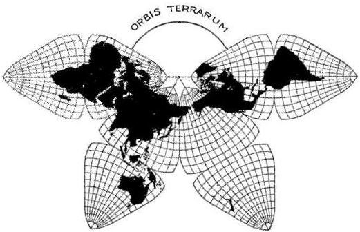
One of the more beautiful, unusual and useful map projections ever devised was created by cartographer Bernard Cahill. The butterfly projection was first published in the Scottish Geographical Magazine in 1909. Cahill (1866-1944) later applied for a US patent to protect his creation.


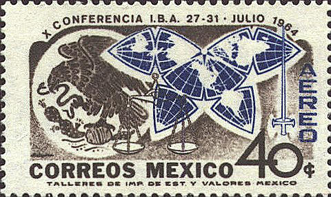
I first came across Cahill’s projection on a stamp issued in Mexico in 1964. The design of the stamp (see image) shows his world map, an octahedral whose eight faces have been flattened into a shape resembling a butterfly. Ever since then I have wondered why such an unusual map would be chosen for a Mexican stamp that commemorated the 10th Conference of the International Bar Association (IBA), held that year in Mexico City. Coming some 20 years after the cartographer’s death, it seems an unlikely choice. So far, all my efforts to find a link between Cahill, the IBA and Mexico have drawn a blank. (Note to readers: Help needed!)

Cahill’s butterfly map, like Buckminster Fuller’s later Dymaxion Maps (1943 and 1954) enabled all the continents to appear linked, and with reasonable fidelity to a globe. Cahill demonstrated this principle by also inventing a rubber ball globe which could be placed under a pane of glass and flattened into the “Butterfly” form. When removed, the map/globe reverted to its original shape.

The original Cahill projection (1909). Credit: Gene Keyes

The original Cahill projection (1909). Credit: Gene Keyes

Largely in honor of his cartographic innovation, Cahill was elected a Fellow of the Royal Geographical Society. In 1913 he started the Cahill World Map Company, but this company was not successful and his map has since been largely forgotten by most people.

But not by cartographer Gene Keyes! Except for Cahill himself, no follower of Cahill’s projection has ever been as dedicated as Gene Keyes, a former student of Buckminster Fuller. Keyes’ website is a mine of information about Cahill and his map projection, and is well worth reading.

Born in the UK, Bernard Joseph Stanislaus Cahill (18661944) was an architect, town planner and cartographer who moved to San Francisco, California, in 1888. He was an early proponent of the San Francisco Civic Center and designed that city’s Neptune Society Columbarium.

Cahill encountered some stiff obstacles in the many years it took him to develop his butterfly projection. For example, he lost all his initial drawings and papers in the disastrous San Francisco earthquake and fire of 1906. At least one major publisher signed a contract to publish the butterfly map as a wall map and in an atlas, but then failed to follow through.

Cahill’s world map used for world tours

Soon after its creation, Cahill’s butterfly map was used to illustrate a flying trip around the world, or circumaviation, proposed for the Panama Pacific International Exposition held in San Francisco in 1915. The map was exhibited at this exposition and won a gold medal for cartography. Some time later, the map was used by both the State of California and the City of Charleston to illustrate shipping routes.

In 1924, the American Express Company chose the map for use during a world tour aboard the Cunard ocean liner Laconia. According to Keyes, the map was prominently displayed on the Palm Deck of the ship and seen by Robert Ripley, a participant on the world tour, who later featured it in his Believe it or Not series.

Perhaps the closest Cahill came to seeing his map in more general use came in 1937, when the International Meteorological Committee apparently came within a single vote of adopting a version of his projection for all world weather charting.

No wonder, then, that in Keyes’ words, “Cahill should be seen in company with other pioneers such as Charles Babbage or Gregor Mendel, who died long before their efforts gained wider appreciation. As well, he antedates Buckminster Fuller, prophet of Spaceship Earth.”

Keyes goes on to note that, “Cahill was not merely an astute architect and cartographer, but, that like Fuller, his map expressed an underlying whole-earth philosophy much like themes which emerged 60 years later. Cahill used the term “geosophy” in that regard….” (And used it as early as 1912, well before the geographer J.K. Wright, commonly credited for having coined the term in 1947).

Will Cahill’s map ever catch on? The latest sign of renewed interest in Cahill’s projection comes from its adaptation by the New York Times as the basis for a series of 10 maps published in December 2011 illustrating the changing world of computing, communications and technology.

Keyes closes his account of Cahill’s map by quoting Ambrose Bierce, who in a letter to Cahill, wrote that, “The Butterfly Map is indubitably the right one, but it will be a long time before it gets into general use….”

Sadly, that has proved to be all too true, despite its inclusion in the design of a Mexican postage stamp.

Related posts using Mexican stamps for illustration:

The development of Huatulco, the tourist resort in southern Oaxaca

 Other  Comments Off on The development of Huatulco, the tourist resort in southern Oaxaca
Jan 302017
 

Huatulco is best known as one of Mexico’s leading tourist resorts, one of several similar large-scale, purpose-built developments partially funded by federal funds.

In 1967, responding to bullish predictions of US demand for beach vacations, Mexico’s central bank identified the five best places for completely new, purpose-built tourist resorts. Top of the list, as part of a 30-year plan, was the uninhabited barrier island now known as Cancún (see The growth of Cancún, Mexico leading tourist resort). The other choice locations were Ixtapa, Los Cabos, Loreto and Huatulco. The National Fund for Tourism Infrastructure (renamed the National Tourism Development Fund, Fonatur, in 1974) began building Cancún in 1970 and Ixtapa in 1971.

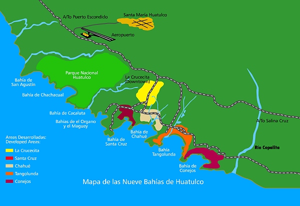
Huatulco’s site on the coast of Oaxaca had been initially identified in 1969 but the area lacked adequate transportation infrastructure until the regional highways were improved in 1982. Legal land expropriations followed; by 1984 Fonatur controlled more than 21,000 hectares (50,000 acres). In 1985 Fonatur began construction of an airport and a service town, La Crucecita, a few kilometers back from the coast. In 1986 the villagers of the coastal community of Santa Cruz were resettled in La Crucecita. Most of Huatulco’s nine bays were linked by paved road by 1987 (see map).

Sketch map of Huatulco (not to scale)

Sketch map of Huatulco (not to scale)

Fonatur took a number of steps to help the original residents adapt to the massive changes taking place around them. It built schools, held public meetings, provided medical and police services, and offered job training programs. Most people gradually adapted; some are employed in Huatulco hotels and some started their own small businesses. By 1994 Huatulco had 1905 hotel rooms and attracted 170,000 tourists, 26% of them foreign. The average length of stay was 4.22 days.

Huatulco’s growth has not been as rapid as Cancún’s. By 2006, Huatulco had 2506 rooms and played host to 312,000 tourists (15% foreign). While Cancún first attracted Mexican tourists and then foreign tourists followed (and now dominate), in Huatulco the proportion of foreign tourists has fallen as the resort has developed. The master plan for Huatulco foresees 30,000 hotel rooms and a city with an eventual population of 600,000.

As for most of its other developments, Fonatur’s construction of La Crucecita established a clear spatial and visual divide between the tourist areas on the coast and the residential areas for tourism employees, in this case on the inland side of some low hills.

So far, so good, but critics of centrally-planned, “top-down” resorts like those built by Fonatur, and of Huatulco in particular, point to the tremendous strains placed on the local inhabitants and on the local environment. We look at some of these in more detail in Villages near Huatulco, Oaxaca: a case study in the “Integrated Administration of Natural Resources”

Related posts:

Population change in Jalisco, 2000-2010

 Maps  Comments Off on Population change in Jalisco, 2000-2010
Jan 242017
 

During the ten years between 2000 and 2010, Jalisco’s population increased by over a million from 6,322,002 to 7,350,355. Suburbs around Guadalajara dominated demographic change increasing by 887,301 (43.2%) to 2,940,118 (see Population change in the Guadalajara Metropolitan Area). The greatest growth was in the southern suburb of Tlajomulco which grew 237% from 123,619 to 416,552. Interestingly, the population of the central city of Guadalajara decreased by 152,185 to 1,494,134.

In this post, we look at the pattern of population change for the other municipalities in the state of Jalisco. The map shows the average annual percentage change in population for the period 2000-2010. It is worth noting that the population of a place with an annual growth rate of 3% will double in about 24 years.

Map of population change in Jalisco

Population change in Jalisco, 2000-2010. Copyright Tony Burton. Click image to enlarge.

What other areas of Jalisco are growing fastest?

Puerto Vallarta, the other major urban area in the state, grew by 38% to 255,725. The northern suburbs of Puerto Vallarta in the state of Nayarit grew even faster. The other major ex-pat area around Lake Chapala grew more slowly. Chapala grew by 12.4% to 48,812, Jocotepec by 18.0% to 42,142, while Poncitlan increased by 18.6% to 48,407.

Jalisco grew by 16.3% during the decade or an average increase of about 1.5% per year. But rates of population growth varied greatly from one area to another.

As indicated in the map, many of the isolated rural municipalities in the state actually declined in population (yellow-green and yellow areas). While births in these rural communities generally exceeded deaths, they experienced significant out migration.

In addition, many other rural communities in western Jalisco grew slowly at less than 1% per year (light pink on the map). Most of the communities in eastern Jalisco grew 1 – 2% about the same rate as the state as a whole.

Surprisingly, three of the most isolated municipalities in far northern Jalisco grew rapidly at over 3% per year. These municipalities are home to many indigenous Huichol Indians. Only relatively low numbers of Huichol Indians have migrated away from their ancestral homelands, so out-migration from these municipalities is much lower than from other remote parts of the state. In recent years, mining activity which was the mainstay of the economy of this area in colonial times, has made something of a comeback, thereby increasing local economic activity and opportunities.

Methodological note: The map depicts the municipal boundaries as they existed in the year 2000. Since that time, the municipality of Arandas has been split into two, reducing its territorial extent, and creating the new municipality of San Ignacio Cerro Gordo.

The pattern of Catholicism in Mexico

 Excerpts from Geo-Mexico  Comments Off on The pattern of Catholicism in Mexico
Jan 162017
 

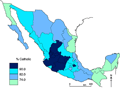
The map shows the percentage of the population of each state who profess themselves to be Catholic. Mexico’s population is predominantly Catholic but Mexican Catholicism is extremely varied in practice. It ranges from those who support traditional folk religious practices to those who adhere to the highly intellectualized liberation theology.

Catholicism in Mexico

Catholicism in Mexico, 2010.

While the population remains predominantly Catholic, allegiance to the church has declined steadily since 1970. In 1970 96% of the population five years of age and older identified itself as Roman Catholic. By the 2010 census the figure had fallen to 84%. Though the proportion of Catholics is declining in Mexico, it is still considerably higher than in Mexico’s southern neighbors. For example, only about 70% in Guatemala are Catholic.

There are significant regional variations. Catholicism is strongest in a band of central-western states, extending from Zacatecas to Michoacán, where only one in twenty is not Catholic. In such areas, religion is a strong force in everyday life, with visible manifestations not only in the number of churches and other ecclesiastical buildings but also in the cultural importance and frequency of religious festivals and processions.

In contrast, about one in six is not Catholic in the northern border states. In southeastern Mexico (Chiapas, Campeche, Tabasco and Quintana Roo), about one in four is not Catholic. Interestingly, non-Catholics are concentrated in both the prosperous northern states and in the relatively poor south and southeastern states.

In summary, the pattern of Catholicism in Mexico exhibits a clear distance-decay pattern around the strongly-Catholic western states, with minor anomalies such as the state of Yucatán.

For more details, see these previous related posts:

Is Jalisco the most “Mexican” state?

 Other  Comments Off on Is Jalisco the most “Mexican” state?
Jan 092017
 

Tapatíos (residents of Guadalajara) and Jaliscienses (residents of Jalisco) often brag that they live in the most “Mexican” area of the country. Are these boasts truthful? This is not an easy question to answer. It involves looking at a broad range of evidence.

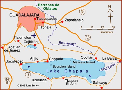
Jalisco’s climate and natural ecosystems are very diverse like the country as a whole. It is the only state with all of the country’s five principal natural ecosystems (tropical evergreen forest, tropical deciduous and thorn forest, temperate forest, grassland and mesquite-grassland, and arid and semi-arid scrubland) [Geo-Mexico, page 31]. Furthermore, Jalisco has Lake Chapala, the country’s largest natural lake as well as the Colima Volcano, one of the most active in the country. Certainly from a physical geography perspective Jalisco appears the most representative of Mexico as a whole. (For other natural wonders of Jalisco see John Pint’s website: http://ranchopint.com).

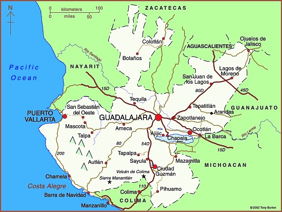
Map of Jalisco state

Map of Jalisco. Copyright 2010 Tony Burton. All rights reserved.

Jalisco’s socio-economic characteristics are also representative of Mexico. Its population has an average growth rate and is distributed among a very large city, secondary and smaller cities, extensive farming communities and isolated indigenous areas. While its adjusted per person income is just below the national average, its human development index (composed of infant mortality rate, adult literacy, school enrollment ratio, and adjusted average personal income) is slightly above. Jalisco is similar to Mexico regarding the main economic sectors of agriculture, industry and services, including tourism.

From a tourism perspective, Jalisco includes everything Mexico has to offer: fantastic beach resorts, urban cultural and artistic attractions, natural wonders, significant indigenous areas and impressive archeological sites. On the other hand, Jalisco is not representative in that it is the leading agricultural state (first in production of corn, beef, pork, poultry, milk and eggs). It is also more predominantly Catholic and politically more conservative than Mexico as a whole. Aside from these two exceptions, Jalisco is quite representative from a socio-economic perspective.

Perhaps cultural aspects are the most important in determining the most “Mexican” of the 32 states. Here Jalisco really stands out. It is the birthplace of such stereotypical Mexican cultural characteristics as charrería (Mexican horsemanship), jarabe tapatío (Mexican hat dance), mariachi music, and tequila, the national drink.

In conclusion, the available evidence appears to support the boasts of some Tapatíos and Jaliscienses that they live in the “most Mexican” area of the country.

Many aspects of Mexico’s culture feature in Geo-Mexico: the geography and dynamics of modern Mexico, a handy reference guide to all aspects of Mexico’s geography. If you have enjoyed this post, consider gifting a copy of Geo-Mexico to someone you know.

Changing customs in Mexico: children forgo Three Kings Day in favor of Christmas Day

 Other  Comments Off on Changing customs in Mexico: children forgo Three Kings Day in favor of Christmas Day
Jan 022017
 

Unlike in the USA and Canada, where gifts are exchanged on Christmas Day (25 December), the original tradition in Mexico over the Christmas season was to exchange presents on Three Kings Day (Día de los Reyes, 6 January). In the Christian calendar, 6 January marks the Feast of the Epiphany, the day when the magi arrived in Bethlehem with their gifts for the infant Jesus. In homage to this occasion, Mexican children would dutifully stuff the largest shoes (or box) they could find with straw, and leave them outside their bedroom door on the night of January 5, in anticipation of finding new toys the following morning.

In the 20th century the Three Kings Day tradition in some regions of Mexico broke down in the face of the enormous consumer-oriented publicity from north of the border, which stressed Christmas (rather than Epiphany) gifts. Naturally, however, some greedy Mexican middle- and upper-class children expect to receive gifts on both days, claiming that parents and grandparents should not only preserve the old customs but also embrace the new version! Equally, children with parents who are separated or divorced also often receive gifts on both 25 December and 6 January, with each parent taking responsibility for one of the two festive days.

Rosca de Reyes

A typical family-sized Rosca de Reyes

Even where it is no longer a day to exchange gifts, 6 January is still very much a family day throughout Mexico. In the late afternoon or early evening, it is traditional for the whole family to share a rosca. Roscas are ring-shaped loaves of sweet bread, sold to be eaten on special occasions. The roscas for Three Kings Day each contain a small plastic (formerly ceramic) muñeco (doll). These muñecos were originally ceramic, but are now more usually plastic. The recipient of the piece of rosca containing the muñeco has to throw a party on 2 February (Candlemas day, Día de la Candelaria) for all those present at the sharing of the rosca. It is customary to provide tamales to feed everyone gathering on Candlemas day. In some parts of southern Mexico,  guests expect to be served home-made mole, a sauce which contains dozens of ingredients including nuts, chocolate and numerous spices, and which requires many hours of arduous preparation.

In 2011, Mexico City residents were treated to an early Three Kings Day present. On Sunday 2 January, the main central square in Mexico City filled with people pushing through the crowds to receive their free portion of the world’s largest ever rosca – a staggering 720 meters long, 90 cm wide and weighing 9,375 kilograms. More than 300,000 people eventually collected a piece to take home for their families to enjoy sometime on Three Kings’ Day.

And if you think making mole is arduous, then just imagine how much work was required to make this enormous rosca! The finished bread was made from 6,000 kg of flour, 3,000 kg of butter, 38,000 eggs, 1,000 kg of fruit, 1,000 liters of milk, and 220 kg of sugar; its preparation took 16,000 man-hours. Given the rising levels of obesity in Mexico, it is to be hoped that the recipe used was for a “reduced calorie” rosca

Credits: Thanks to Fatimah Araneta for suggesting valuable modifications to the original article, and to Cristina Potters for emphasizing that gift-giving on Three Kings Day is still very much alive and well in much of central and southern Mexico. Cristina Potters’ blog Mexico Cooks! has a comprehensive account of the significance of the cuisine associated with Three Kings Day and Candlemas Day.

Many aspects of Mexico’s culture feature in Geo-Mexico: the geography and dynamics of modern Mexico, a handy reference guide to all aspects of Mexico’s geography. If you have enjoyed this post, please consider gifting a copy of Geo-Mexico to a friend.

Dec 172016
 

Most of Mexico is above 1000 m (about 3300 ft) in elevation; as a result most of Mexico has a more temperate climate than might be expected given its latitude.

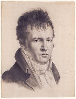
The famous explorer Alexander von Humboldt, one of the founding fathers of physical geography and meteorology, was the first to describe the vertical differentiation of climatic and vegetation zones in Mexico. Writing in 1811, he proposed the terms tierra caliente, tierra templada, and tierra fría, still widely used by non-specialists today.

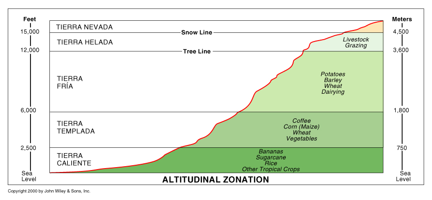
Tierra caliente (hot land) includes all areas under about 900 m (3000 ft). These areas generally have a mean annual temperature above 25°C (77°F). Their natural vegetation is usually either tropical evergreen or tropical deciduous forest. Farms produce tropical crops such as sugar-cane, cacao and bananas.

Altitude zones

Altitude zones. Copyright John Wiley & Sons Inc. 2000.

Tierra templada (temperate land) is the area between 900 and 1800 m (3000 to 6000 ft) where mean annual temperatures are usually between about 18°C and 25°C (64°F to 77°F). The natural vegetation in these zones is temperate forest, such as oak and pine-oak forest. Farms grow crops such as corn (maize), beans, squash, wheat and coffee.

Tierra fria (cold land) is over 1800 m (6000 ft) where mean annual temperatures are in the range 13°–18°C (55°–64°F). At these altitudes pine and pine-fir forests are common. Farm crops include barley and potatoes. On the highest mountain tops, above the tierra fría is tierra helada, frosty land.

Even higher, and almost permanently under snow and ice, is the tierra nevada, snow-covered land.

Dec 082016
 

Corn (maize) has been the principal food of the Tarahumara Indians since long before the Spanish arrived in Mexico. There are several precolumbian varieties that are still grown, including the ancient and delicious “blue corn”. Maize is the source of a wide variety of foodstuffs and drinks including flour (pinole), a non‑alcoholic drink called esquiate, tortillas, atole and tamales. Green corn and blue corn tortillas are made when in season, for special occasions. A version of corn beer (Spanish “tesgüino“) is also important, and is described separately below.

The Tarahumara continue to “hunt and gather” locally available foodstuffs, though these activities now supply only about 10% of their diet. Several varieties of cactus fruit are collected, edible agaves are cooked, and small river fish are caught where possible. Small animals are ruthlessly hunted. Squirrels, birds and deer, though rare today, are considered particular delicacies.

Beans, mustard green and squash also play important parts in the Tarahumara diet which is rounded out by wheat, potatoes, peaches and sweet potatoes. Those Tarahumara with access to lower elevations, such as Batopilas Canyon, also include crops typical of warmer regions such as oranges, figs and sugar‑cane. Chiles and tobacco are also cultivated.

Meat is hard to come by, and eaten only on ceremonial occasions when a goat or cow is sacrificed. It probably accounts for less than 5% of the average Tarahumara diet. Most protein comes from beans; these are usually prepared by roasting, grinding and then boiling with water, to produce a hot soup. Pork, chicken and eggs are rarely found, while sheep are kept mainly for their wool.

Squash is only eaten in season though the Indians know how to preserve it by drying. The squash flowers are eaten too, boiled with water and salt. Mustard greens (Tarahumara “maquasori“, Spanish “quelites“) are grown in the rainy season and carefully gathered and dried, for use throughout the year, providing minerals and vitamins. Quelites include the epazote plant (Chenopodium ambrosioides), described by Diana Kennedy, the world’s foremost authority on Mexican cuisine, as “the Mexican herb par excellence”.

Many families have a small number of scrubby fruit trees, usually peaches, near their house. Fruit is often picked and eaten green. Peaches are an important trading item, and may be exchanged for cigarettes or cloth. At higher elevations, apples are grown.

Given the well-documented endurance feats of Tarahumara runners, this diet clearly provides adequate nutrition! In the 1994 Denver, Colorado, “Sky Race”, Tarahumara Indian Juan Herrera (25 years old) smashed 25 minutes off the previous record, completing the 160 kilometers in 17 hours, 30 minutes, 42 seconds. He came in more than half an hour ahead of his nearest rival!

However, in many years (including 2011, 2012), and seemingly with increasing frequency, food is in extremely short supply by the time the summer growing season arrives. Fortunately for the less successful Tarahumara farmers, an age‑old tribal custom, korima is still observed. This custom requires the better‑off to share food with the less fortunate in times of need. The poor person visits successive ranchos, collecting small quantities of food to last him a week or two, then repeats this procedure as necessary. No lasting debt is incurred. The severe drought in northern Mexico over the past 24 months – see Many states in Mexico badly affected by drought – has meant that many Tarahumara have no food reserves left and have had to rely on infrequent emergency aid organized by charitable organizations, and the federal and state government.

Tesgüino (corn beer)

The average Tarahumara family expends 100 kg of corn a year to make tesgüino. This is sufficient corn to last a family of 4‑5 about a month, a significant quantity, given the regular annual food deficiencies in this region.

Tesgüino is a form of corn‑beer. It is a thick, milky, nutritious drink, supplying much needed vitamins, minerals and calories. The corn is first dampened and allowed to sprout in a dark place, then ground and boiled for about 8 hours with a catalyst to promote fermentation. The catalyst may be local grass seed (basiahuari) ground in a metate, or bark, leaves, lichens or roots, depending on the place. The liquid is then strained and left to ferment for about three days. The total preparation time is therefore about seven days. To avoid spoilage, the beverage must be drunk quickly. It’s at its best for only 12‑24 hours. This explains why it would be so wasteful to leave any corn beer tesgüino undrunk at a “tesgüinada” (see below); it would be far too wasteful, even if as many as 50 gallons have been made.

Other alcoholic drinks are also made, one based on green corn (pachiki or caña) and another on maguey (meki). In earlier times, there were no alcoholics as we define the term, since tesgüino can’t be stored, but today the greater availability of commercial alcohol poses a serious problem.

Why are tesgüinadas so important?

The tesgüinada system is the social device which ties individual settlements (ranchos) together in a cooperative framework for performing all kinds of agricultural tasks. The person requiring assistance with a particular task will invite his neighbors and friends to a “tesgüinada”. He takes responsibility for providing the tesgüino, other refreshments and food. In return, the persons who attend will help plow. sow, reap or weed..

Lumholtz, recognizing from his time among the Tarahumara at the end of the last century the importance of the tesgüinada, summed up their philosophy writing that, “Rain cannot be obtained without tesgüino. Tesgüino cannot be made without corn and corn cannot grow without rain.”

The tesgüinada is necessary since many families cannot supply the labor required for both herding and cultivation at certain times of the year. In small groups like the ranchos, high mortality inevitably leaves some families unable to manage on their own. The tesgüinada is their response to the economic uncertainties facing them just as collective religious rituals help them face the unpredictability of weather, sickness and plagues. The cooperative effort moves from one rancho to another, from one tesgüinada to the next.

The tesgüinadas, which are like large, boisterous parties, provide a focus for Tarahumara social life, a chance for entertainment and to make extra-familiar friendships. Being held in a succession of different ranchos, they offer some communal resilience against the risks of becoming further isolated and marginalized. The Tarahumara attach no shame to being drunk; indeed, they positively revel in getting as drunk as humanly possible at tesgüinadas. Children are excluded until they are 14 years old or so.

Tesgüinadas do come at a cost. They increase the incidence of accidents, such as adult men falling off precipitous rock ledges that would normally pose little risk, even when running. They increase violence, which may result in serious injury or death. They also limit the amount of corn that can be held over from one year to the next. Assuming an average of 4‑6 tesgüinadas per year per family, with additional visits to tesgüinadas held in perhaps 15 other households, many Tarahumara Indians would be likely to attend more than sixty tesgüinadas a year. Even if the true figure is only 50% of this total, it still means that the Tarahumara spend as many as 100 days a year either preparing for a tesgüinada, attending one, or recovering from one.

Sources /  Bibliography:

  1. Bennett, W. and Zingg, R. (1935) The Tarahumara. Univ. of Chicago Press. Reprinted by Rio Grande Press, 1976.
  2. Kennedy, J.G. (1978) Tarahumara of the Sierra Madre; Beer, Ecology and Social Organization, AHM Publishing Corp, Arlington Heights, Illinois. Republished, as The Tarahumara of the Sierra Madre: Survivors on the Canyon’s Edge in 1996.
  3. Lumholtz, C. (1902) Unknown Mexico. 2 volumes. Scribner’s Sons, New York. Republished in both English and Spanish.
  4. Pennington, C. (1963) The Tarahumar of Mexico, their environment and material culture. Univ. of Utah Press. Reprint by Editorial Agata, Guadalajara, 1996.

Related posts:

The geography of tequila: where is tequila made?

 Other  Comments Off on The geography of tequila: where is tequila made?
Nov 142016
 

The production of (genuine) tequila is tightly regulated because tequila has denomination of origin status. This status (sometimes called appellation of origin) sets specific standards for producers in terms of how a product is grown or produced, processed and presented. Equally importantly, it defines the geographic indication, the specific places or regions where the product has to be made. Other items having denomination of origin status include champagne, asiago cheese and Melton Mowbray pork pies.

Geographic indications are “indications which identify a good as originating in the territory of a Member, or a region or locality in that territory, where a given quality, reputation or other characteristic of the good is essentially attributable to its geographic origin.” (World Trade Organization)

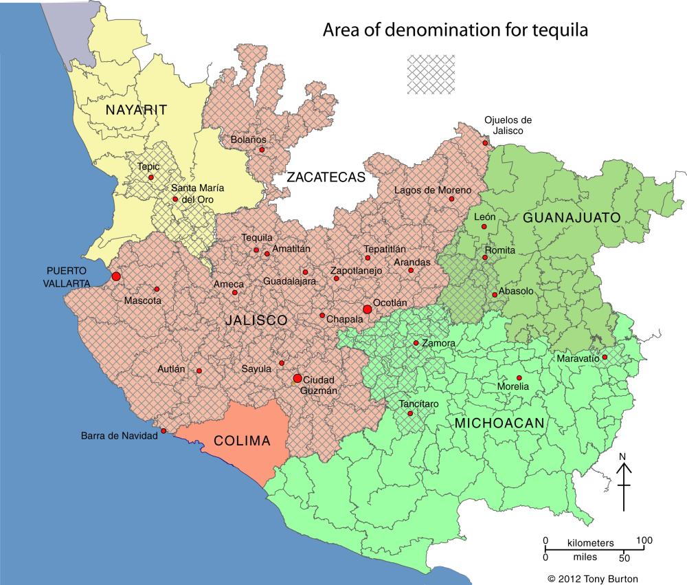
Mexico’s denomination of origin area for genuine tequila includes includes 180 municipalities in five states, a total area of about 11 million hectares (27 million acres).

Tequila producing areas of Jalisco and neighboring states.

Tequila producing areas of Jalisco and neighboring states. Credit: Tony Burton; all rights reserved. Click to enlarge

The main area (see map above) is the state of Jalisco (all 124 municipalities), with extensions into three neighboring states:

  • Nayarit (8 municipalities): Ahuacatlán, Amatlán de Cañas, Ixtlán del Río, Jala, Xalisco, San Pedro Lagunillas, Santa María del Oro and Tepic.
  • Guanajuato (7 municipalities): Abasolo, Cd. Manuel Doblado, Cuerámaro, Huanimaro, Pénjamo, Purísima del Rincón and Romita.
  • Michoacán (30 municipalities): Briseñas de Matamoros, Chavinda, Chilchota, Churintzio, Cotija, Ecuandureo, Jacona, Jiquilpan, Maravatío, Marcos Castellanos, Nuevo Parangaricutiro, Numarán, Pajacuarán, Peribán, La Piedad, Régules, Los Reyes, Sahuayo, Tancítaro, Tangamandapio, Tangancicuaro, Tanhuato, Tinguindín, Tocumbo, Venustiano Carranza, Villa Mar, Vista Hermosa, Yurécuaro, Zamora, and Zináparo.
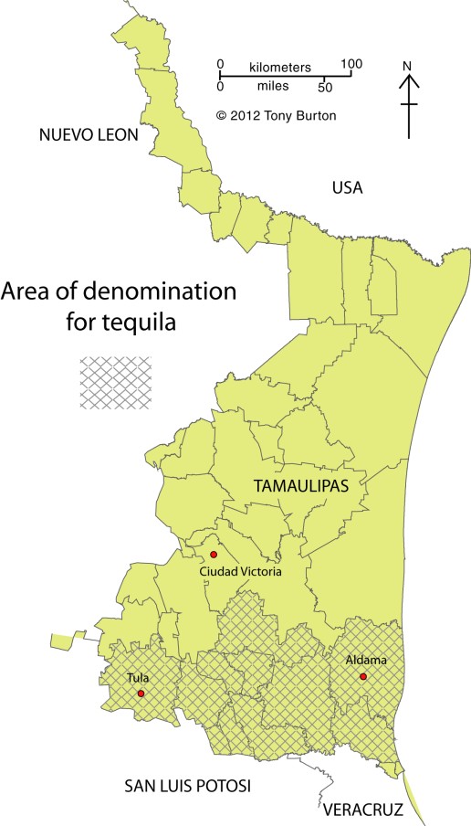
Tequila growing area in Tamaulipas.

Tequila growing area in Tamaulipas. Credit: Tony Burton; all rights reserved. Click to enlarge.

About 80% of all blue agave is grown in Jalisco, and almost all tequila distilleries are located in the state.

The municipality of Maravatío in the eastern section of Michoacán is a tequila outlier, some distance away from the main producing area centered on Jalisco.

The other major outlier is a group of 11 municipalities in the northern border state of Tamaulipas (see second map) where 11 municipalities (Aldama, Altamira, Antiguo Morelos, Gómez Farías, González, Llera, Mante, Nuevo Morelos, Ocampo, Tula and Xicotencatl) are included in the denomination of origin for tequila.

The first denomination of origin for tequila was registered with the World Intellectual Property Organization in 1978. Since that time every trade agreement signed by Mexico has contained a clause to ensure that tequila’s special status is fully protected by the other signatories. Mexico has signed free trade agreements with more countries than any other country in the world.

For example, the relevant NAFTA clause states that:

“Canada and the United States shall recognize Tequila and Mezcal as distinctive products of Mexico. Accordingly, Canada and the United States shall not permit the sale of any product as Tequila or Mezcal, unless it has been manufactured in Mexico in accordance with the laws and regulations of Mexico governing the manufacture of Tequila and Mezcal.”

In 1996, Mexico succeeded in getting the World Trade Organization to recognize tequila, and also mezcal, as denomination of origin products.

The following year, Mexico signed an agreement with the European Union whereby Mexico recognized 175 European spirits, including champagne, cognac, grappa and scotch, as having denomination of origin protection, in exchange for E.U. protection for tequila and mezcal. At that time, Mexico’s Tequila Regulatory Council (CRT) estimated that some 3.5 million liters of “pseudo-tequilas” were sold annually in Europe under such names as “Blue Tarantula” in Italy and “Hot Tequila” in Finland (In search of the blue agave: Tequla’s denomination of origin).

Related posts:

Nov 072016
 

In a previous post – Mexico’s shoe (footwear) manufacturing industry: regional clustering – we looked at the concentration of the shoe-manufacturing industry in three major areas: León (Guanajuato), Guadalajara (Jalisco) and in/around Mexico City. We have also taken a look at Mexico’s international trade in shoes – Mexico’s footwear industry: imports and exports. We now turn our attention to the distribution of shoe retailers within a large Mexican city.

Shoes in Mexico

The retailing of shoes within cities often exhibits distinctive spatial patterns. Many older and larger Mexican cities tend to have all the retailers for a particular item (furniture, electronics, autoparts, etc) concentrated in a very small area. For example, dozens of retail outlets for electronics are located within a few blocks of Mexico City’s main square or zócalo. Electronics stores are in very close proximity to one other, and occupy both sides of the street for several blocks, leaving little or no room for any other retailers.

Another example of retail specialization is Corregidora street, which has several blocks dedicated to the sale of pots and pans, kitchen utensils and table settings.

Elsewhere in Mexico City’s downtown area:

… turn right and continue down Chile street to the intersection with Tacuba street. One of the most fascinating aspects of commercial life in the downtown area of Mexico City is that each area is specialized in some trade or retail activity. Such trading ghettos were also a feature in Tenochtitlán and the practice still exists today. Where you are now walking is the barrio of bridal shops. The greatest concentration of these shops is north of the Heras y Soto House…” (Candace Siegle, Walking through History, a series of walks through Mexico City’s historic center, 1989)

Returning to the subject of shoes, without which no bridal outfit is complete, shoe retailing is also often heavily concentrated in certain sections of Mexico’s larger cities. Perhaps the most extreme example is in Guadalajara, where shoe retailing is concentrated in two main zones. One of these zones is within the central business district, and is comprised of both regular storefronts and a market. The other area is several kilometers west of the center, around Galería del Calzado, a shopping plaza of more than 60 stores entirely dedicated to shoes. The Galería, located where Yaquis meets Avenida México, has a total floor space in excess of 8,600 square meters (92,500 square ft). The shops in Galería del Calzado stock every major brand and type of shoe, and eagerly compete for your pesos.

From a consumer’s perspective, this is all highly convenient and allows for easy comparison shopping. However, I have never been convinced of the advantages of such concentration from the point of view of the retail store owners, unless perhaps they get their stock from a relatively limited number of (shared) shoe distributors?

Despite the success of many Mexican shoe manufacturers, one of the fundamental weaknesses of the supply chain for footwear in Mexico (according to sector analysts) is the absence of any strong specialized marketer dedicated to shoes. Fancy a job marketing cowboy boots, anyone?

Related posts:

Chapters 21 and 22 of Geo-Mexico: the geography and dynamics of modern Mexico analyze Mexico’s 500-year transition to an urban society and the internal geography of Mexico’s cities. Chapter 23 looks at urban issues, problems and trends. Buy your copy of this invaluable reference guide today!

Nov 012016
 

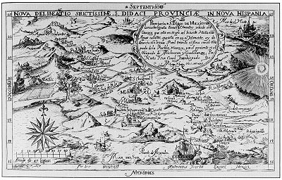
One of the earliest known maps engraved in colonial New Spain (Mexico) was that drawn by Antonio Ysarti in 1682. It shows the Franciscan Province of  San Diego of Mexico, with its 14 friaries, from Oaxaca in the southeast to Aguascalientes in the northwest. It covers the archdiocese of Mexico City, as well as the dioceses of  Puebla and Oaxaca to the east, and Michoacán and Guadalajara to the west.

Ysarti's 1682 map of New Spain

Ysarti’s 1682 map of New Spain; click map for an enlarged version of Mexico City to Acapulco

The beautifully-drawn map was originally published to illustrate Baltasar de Medina’s 1682 Chronica de la Santa Provincia de San Diego de Mexico, printed by Juan de Ribero. In the words of the sellers of this map’s original copper plate to the Library of Congress, “This artifact is tangible evidence of an emerging scientific and artistic community in a growing colonial empire.”

Sadly, very little is known about Antonio Ysarti, the map’s talented cartographer; not even his nationality is known for certain.

The map measures 29 x 19 cm approx (11.25 x 7.25 inches) and names more than 50 places. Each friary is depicted as an architecturally distinct building, not by the use of a common symbol.

Q. How well do you know central Mexico? Click on the map above (to reveal the section between Mexico City and Acapulco) and then see how many places you can identify and match to present-day place names.

Online version of this map, offering the ability to zoom in to specific parts

The changing political frontiers of Mexico are the subject of chapter 12 of Geo-Mexico: the geography and dynamics of modern Mexico, a handy reference guide to all aspects of Mexico’s geography. If you have enjoyed this post, please consider gifting a copy of Geo-Mexico to someone in the coming holiday season.

Basalt columns and prisms can be seen in various places in Mexico

 Other  Comments Off on Basalt columns and prisms can be seen in various places in Mexico
Oct 252016
 

Basalt is a dark, fine-grained, basic (low silica) igneous rock, often extruded as molten lava from volcanic fissures. Its low silica content means it can flow easily, often building up over the years to form large plateaus. As the basaltic lava cools, it contracts and solidifies. An extensive network of cracks often develop in basalt, which may extend many meters deep. These cracks tend to leave columns between them which are roughly hexagonal (6-sided) in shape. Among the more famous examples of basalt columns or pavements in the world are Giant’s Causeway (Northern Ireland), Fingal’s Cave (Scotland) and Devil’s Postpile (California, USA).

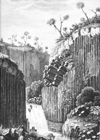
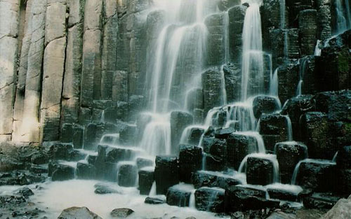
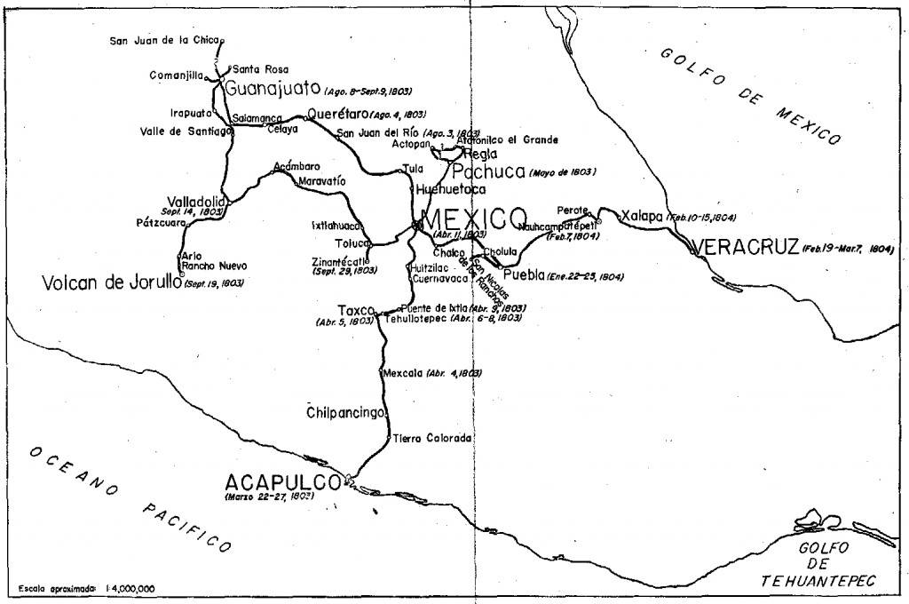
The best known location in Mexico to see basalt columns is about an hour’s drive north of Mexico City, at Santa María Regla, in the state of Hidalgo. These columns, attractively located on the side of a canyon, with a waterfall tumbling over some of them (see sketch), were visited by the famous Prussian scientist/geographer Alexander von Humboldt, during his exploration of Mexico in 1803-04. Some individual columns are 40 meters tall.

Basalt prisms at San Miguel Regla

Basalt prisms at San Miguel Regla, from Humboldt and Bonpland, Vues des Cordilleres et monumens des peuples indigenes de l’Amerique.

The basalt columns of Santa María Regla are one of the locations described in The first geography fieldtrip guide in Mexico. They are also one of Mexico’s top 13 natural wonders.

Basalt prisms at Santa María Regla

Other locations in Mexico where basalt columns or prisms can be seen include a quarry between the towns of Jamay and Ocotlán (Jalisco), the south-facing slope of the hills overlooking the town of Chapala (Jalisco) and the Salto (waterfall) de San Antón (Cuernavaca, Morelos).

Mexico’s geology and landforms are analyzed in chapters 2 and 3 of Geo-Mexico: the geography and dynamics of modern Mexico.  Buy your copy of this book today!

Oct 202016
 

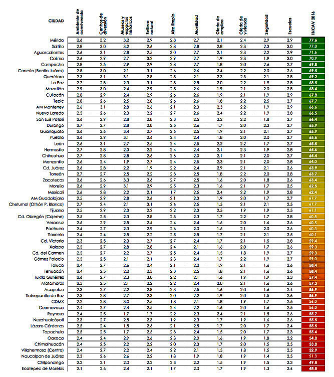
Mexican market research firm Gabinete de Comunicación Estratégica polled 30,400 people across the country to compile its 10th annual survey of the most livable cities in Mexico. The survey was carried out by telephone between 30 June and 19 July this year. Respondents in Mexico’s 60 most populous municipalities and Mexico City’s 16 delegaciones were asked a series of questions related to quality of life and level of services provided in each city. [Given the sample size, at a confidence level of 95% the maximum expected error for each municipality was ±4.9%]

most-livable-cities

The survey looked at numerous variables to quantify “quality of life”, including housing, schools, mobility, air pollution and employment. The survey also considered satisfaction with services, and satisfaction with the performance of the city’s mayor.

best-living-in-citiesFor quality of life, the top ranking city overall, for the second year running, was Mérida (Yucatán), which scored 77.6 points out of 100, followed by Saltillo (77), Aguascalientes (71.6), Colima (70.9) and Campeche (69.8). Monterrey came in 12th in the survey rankings (see table), while Guadalajara placed in the middle.

The four least livable cities in the study were Villahermosa (52.9), Naucalpan (51.3), Chilpancingo (49.8) and Ecatepec (48.8).

  • Full report: Ciudades más habitables de México 2016 (pdf)

Related posts:

The deepest water-filled sinkhole in the world is in Tamaulipas, Mexico

 Other  Comments Off on The deepest water-filled sinkhole in the world is in Tamaulipas, Mexico
Oct 122016
 

As vertical shafts go, this is a seriously deep one! Long considered to be “bottomless” (because no-one had ever managed to find the floor), we now know it is precisely 335 meters (1099 feet) deep, making it the deepest water-filled sinkhole anywhere on the planet.

The El Zacatón sinkhole is on El Rancho Azufrosa, near the town of Aldama in Tamaulipas in northeast Mexico. The sinkhole or cenote is one of several located in the same area, though recent studies have failed to demonstrate any obvious underground connections between them. The term cenote is a Spanish rendering of the Mayan word d’zonot, “a hole in the ground”. The El Zacatón pit, which is about 110 meters (360 feet) across and roughly circular, contains a deep lake. The water is warm (averaging about 30 degrees C), highly mineralized and has a sulfurous odor. The name El Zacatón comes from the floating islands of grass (zacate) which blow across this lake from one side to the other with the wind.

The pit’s depth has attracted serious divers for many years. In 1993, Dr. Ann Kristovich dove to a new women’s world record depth of 169 meters (554 feet). The following year, two American explorers tried to reach the bottom of the sinkhole. Jim Bowden successfully reached a men’s world record depth of 282 meters (925 feet) but still did not touch the bottom. Tragically, his diving partner Sheck Exley died during the attempt.

The mystery of the sinkhole’s depth was finally solved in 2007. A multi-million dollar exploration, mainly funded by NASA, trialled the Deep Phreatic Thermal Explorer (DEPTHX) robot, designed to explore ice-covered Europa, Jupiter’s smallest moon. Partners on the DEPTHX project include Carnegie Mellon University, Southwest Research Institute, Colorado School of Mines, The University of Arizona, and the University of Texas at Austin’s Jackson School of Geosciences. In the words of a NASA press release, The Deep Phreatic Thermal Explorer (DEPTHX) is a 3,300-pound, computerized, underwater vehicle that makes its own decisions. With more than 100 sensors, 36 onboard computers, and 16 thrusters and actuators, it decides where to swim, which samples to collect, and how to get home.

Exploring El Zacatón pit was considered to be an ideal preliminary test of the DEPTHX autonomous robot, which is about the size of a go-kart. The robotic vehicle successfully generated a highly detailed sonar map of the sinkhole, and obtained samples of water and biotic material from the walls, discovering several new phyla of bacteria in the process. Its next challenge is to explore beneath the ice of West Lake Bonney in Antarctica.

At El Zacatón, the sonar study showed that the sinkhole has a total depth of 335 meters: the lake is 319 meters deep at its deepest point, and its surface is 16 meters below the height of the sinkhole’s rim.

Related post:

Sources / Further reading:

Mexico’s geology and landforms are analyzed in chapters 2 and 3 of Geo-Mexico: the geography and dynamics of modern Mexico.  Buy your copy of this book today!

Oct 062016
 

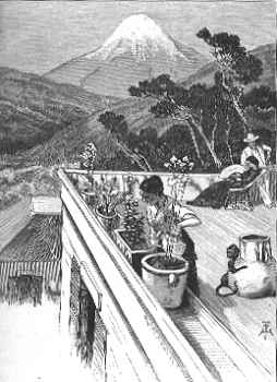
El Pico de Orizaba, or Citlaltépetl (= “star”), is Mexico’s highest peak, rising to a summit 5,610 meters (18,406 feet) above sea level. The third highest peak in North America, it is also that region’s highest volcano, responsible for major eruptions in 1569, 1613 and 1687. The mountain was first explored by scientists as long ago as 1838.

Located east of Mexico City, some 30 kilometers (20 miles) northwest of the city of Orizaba, it is regularly climbed today by well-equipped groups, especially during the dry season, from December to April. Its classical cone shape masks an impressively large crater, which is more than 300 meters (1,000 feet) deep. The volcano and surrounding area were declared a national park by President Lázaro Cárdenas in 1936; the decree took effect the following January.

Among the first recorded ascents is that in August 1838 by a group of several European botanists: Henri Galeotti, Nicolas Funck, Auguste Ghiesbreght and Jean-Jules Linden.  The group spent eleven days on the volcano and their subsequent accounts of the expedition show that they definitely reached the summit. Afterwards, they went on to have distinguished careers in their specialist fields.

By the time of the climb, Henri Guillaume Galeotti (1814-1858) had already written a landmark article about Lake Chapala, and made numerous botanical discoveries in Mexico. He went on to become Director of the Royal Botanical Gardens in Brussels, Belgium.

Less is known about the achievements of Nicolas Funck (1816-1896), who continued traveling in Mexico until 1842. He subsequently became director of Brussels Zoo (1861) and then Cologne Zoo.

After the climb, Auguste Ghiesbreght (1810-1893) set up his own business in Mexico, making a living by supplying plants and natural history specimens to European collectors and his botanist business partners. Who knows? Perhaps the plans for a cacti-exporting business (Galeotti) and large-scale orchid cultivation (Linden) were hatched while the group of young friends were battling their way towards the peak of Orizaba.

Jean Jules Linden (1817-1898), born in Luxembourg, collected for the Belgian government in Brazil, Mexico and Guatemala, before becoming one of the world’s most celebrated importers of plants. He set up nurseries for exotic plants in Brussels and Ghent in Belgium, as well as on the French Mediterranean coast. He also directed Brussels Zoo. He is credited with introducing and popularizing numerous plants, including begonias, palm trees and orchids. His superb publications on orchids and his marketing skills won him world-wide respect.

The nineteenth century craze for orchids in Belgium had numerous parallels with the craze three hundred years earlier for tulips in the Netherlands. The nouveau-riche industrialists satisfied their passion for expensive and unusual orchids by buying them from Linden who was propagating and growing them in massive, industrial-scale glasshouses. Even the Russian czar bought orchids from Linden!

El Pico de Orizaba (from Oswald’s Summerland Sketches, 1880)

The explorations of Galeotti and his friends resulted in the volcano becoming much better known. A decade later, Carl Sartorius, an artist of German extraction who collected plants for the Berlin Botanical Gardens, and who owned the El Mirador hacienda close to the volcano, organized an expedition to reach the summit. When they reached the top, they found a simple plaque there already, left by two US soldiers, F. Maynard and G. Reynolds, who had served as troopers in Winfield Scott’s army during the 1846-1848 Mexican-American war.

Not surprisingly, the upper reaches of El Pico de Orizaba (above about 4,000 meters) are snow-capped all year. Though someone had probably skied down the mountain previously, the first recorded descent on skis was made by W. Furlinger in 1974. Schemes to open a skiing resort on its slopes have been suggested several times. Before any budding entrepreneurs get carried away with the possibilities, it should be pointed out that setting up permanent ski runs on the slopes of El Citlaltépetl may not be too smart an idea, given the likely impact of global warming.

This is an edited and updated version of an article originally published on MexConnect.

Acknowledgment

My thanks to Dr. Winston Crausaz. the author of Pico de Orizaba or Citlaltepetl (Geopress International, 1993), whose valuable comment on the original post (see below) has now been incorporated into the updated version above.

Mexico’s volcanoes, mountains and relief features are examined  in chapters 2 and 3 of Geo-Mexico: the geography and dynamics of modern Mexico.

Mexican architect proposes city straddling Mexico-U.S. border

 Mexico's geography in the Press  Comments Off on Mexican architect proposes city straddling Mexico-U.S. border
Oct 032016
 

This proposal sounds a lot more 21st century than Trump’s plan for a wall along the Mexico-U.S. border. Will either proposal ever actually happen? Most likely not. But that does not prevent us from considering the former project one more than worthy of mention here.

Young Mexican architect Fernando Romero has long believed that “building bridges” is preferable to creating obstacles and that conventional boundaries “are just becoming symbolic limits.”Romero was named a “Global Leader of Tomorrow” at the World Economic Forum in 2002.

Masterplan for trans-border city. (Fernando Romero Enterprise)

Masterplan for trans-border city. (Fernando Romero Enterprise)

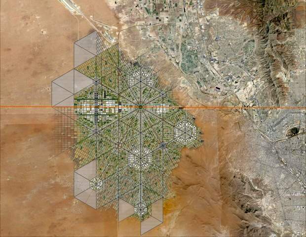
To illustrate his viewpoint, Romero recently released a master plan for a walkable, super-connected metropolis straddling the U.S.-Mexico border. More than a decade ago, Romero’s architecture firm proposed a tunnel-like “Bridging Museum” crossing the Mexico-U.S. border in the Rio Grande Valley. His more recent suggestion of a utopian border city, presented at the London Design Biennale, is far more ambitious and would take advantage of the concept of special economic zones (employed earlier this year by Mexico’s federal government to stimulate development in several southern states).

To read more about this exciting proposal, with numerous stunning images of what it might look like, see “Instead of Trump’s Wall, Why Not a Binational Border City?

For more about the U.S.-Mexico border zone, see these related Geo-Mexico posts:

Alexander von Humboldt’s visit to Mexico, 1803-1804

 Other  Comments Off on Alexander von Humboldt’s visit to Mexico, 1803-1804
Sep 292016
 

Alexander von Humboldt‘s visit to Mexico began in Acapulco on March 22, 1803, and lasted for almost a year. (He left Mexico via Veracruz for the USA on March 7, 1804.) In his year in Mexico, Humboldt had been incredibly busy. He had measured, recorded, observed and written about anything and everything, with remarkable industry and accuracy. He had climbed mountains, burned his boots on active volcanoes, descended into mines, recorded geographical coordinates, and collected numerous specimens and antiquities. Humboldt’s Political Essay on the Kingdom of New Spain was the first systematic scientific description of the New World. It appeared in 1811, and marked the birth of modern geography in Mexico. His figures and ideas were used and quoted by writers for many many years.

Humboldt had also drawn a large number of maps, drawings and sketches and it can rightly be claimed that the modern era of Mexican map-making began with Alexander von Humboldt, and was then developed further later in the 19th century by cartographers such as Antonio García Cubas.

Humboldt's route in Mexico

Humboldt’s route in Mexico. Click to enlarge

Alexander von Humboldt (Self-portrait c1814)

Alexander von Humboldt (Self-portrait c1814)

The map above shows the route followed by Humboldt during his time in Mexico. The map comes from the book La obra de Alexander von Humboldt en México by Rayfred Lionel Stevens-Middleton  (Mexico D.F.: Instituto Panamericano de Geografía e Historía, 1956). This hard-to-find work is a comprehensive account of Humboldt’s time in Mexico and of his significance for the development of what the author refers to as “modern geography”.

The map of Humboldt’s route in Mexico includes his various side trips such as those to Jorullo Volcano and Santa María Regla.

Humboldt was keen to see Jorullo Volcano, since it was a rare example of a brand new volcano, one of only a handful of volcanoes that have emerged on land anywhere in the world in historic times. Jorullo first erupted on 29 September 1759 and activity continued for 15 years until 1774. Two centuries later, and about 80 km (50 miles) away, Paricutín Volcano burst into action for the first time, in a farmer’s field in 1943.

Santa María Regla, in the state of Hidalgo, about an hour’s drive north of Mexico City, is the best known location in Mexico for basalt columns. The columns, up to 40 meters tall,  are attractively located on the side of a canyon, with a waterfall tumbling over some of them:

Despite only seeing a relatively small part of the country (New Spain as it then was), Humboldt was able to make some generalizations about geography in general, and Mexican geography in particular, that have stood the test of time remarkably well. For example, he was the first to describe the vertical differentiation of climatic and vegetation zones in Mexico. Writing in 1811, he proposed the terms tierra caliente, tierra templada, and tierra fría, terms still widely used by non-specialists today:

Related posts:

Note: this post was first published on May 7, 2012.

Sep 262016
 

Lake Chapala is Mexico’s largest natural lake. On the geological timescale of millions of years, all lakes are temporary features on the earth’s surface. Once formed, natural processes begin to fill them in and/or to drain them.

Map of Lake Chapala, Jalisco, Mexico. All rights reserved.

Lake Chapala resulted from drastic earth movements, accompanied by earthquakes and faulting which occurred some twelve million years ago. Lake Chapala collected on the floor of a rift valley. Movements along the parallel systems of faults that caused the rift valley still occur today. Evidence for this continued movement can be seen in the cracked or displaced walls of some local buildings.

Given its advanced age, it is not surprising to discover that Lake Chapala was once (thousands of years ago) much larger. In fact, though no-one has so far proven it beyond doubt, it may have been immensely large, covering an area seven times its present area, with a correspondingly long shoreline. At a later stage in its history, it became the deepest lake of an interconnected series of lakes which flooded the valley floors where the towns of Jocotepec, Zapotitan, Zacoalco and Sayula are today. The present Lake Chapala is thus probably only a small remnant of the original version.

The lake is under heavier pressure than at any time in its existence. Local towns and the nearby city of Guadalajara see it as an inexhaustible supply of domestic and industrial water. Tourists see it as a recreation resource, and the thousands of foreign retirees who have settled on its shores see it as a major reason for the area’s beneficial climate.

A case study of ‘residential tourism’ in the villages on the northern shore of Lake Chapala is discussed in chapter19 of Geo-Mexico: the geography and dynamics of modern Mexico.

The levels of flow of the River Lerma, the only river of any size entering the lake, are crucial to the health of the lake. In recent years, demands for Lerma water have multiplied many times over, principally for farms in neighboring states, but also for industries. All the other rivers entering the lake are much smaller and, with rare exception, flow into the lake only a few times a year during the rainy season. The hydrology of Lake Chapala is discussed in chapters 6 and 7 of Geo-Mexico: the geography and dynamics of modern Mexico.

The good news is that Lake Chapala was recently declared an Internationally Important Wetland by the Ramsar Convention, joining a large global network of similarly important wetland sites. The 13th International Living Lakes Conference was held in Chapala, March 22-25, 2010.

This is an edited excerpt from Tony Burton’s Western Mexico, A Traveller’s Treasury (4th edition) .

Which are the best states in Mexico for doing business in 2016?

 Mexico's geography in the Press  Comments Off on Which are the best states in Mexico for doing business in 2016?
Sep 232016
 

A study just released by the World Bank and the International Finance Corporation, Doing Business en México 2016, compares Mexico’s 32 states for the paperwork, time and costs associated with four major indicators: opening a new business, obtaining construction permits, registering industrial property rights and the resolution of commercial disputes.

The report concludes that the seven best states in which to do business are Aguascalientes, the State of Mexico, Colima, Puebla, Sinaloa, Guanajuato and Durango, all of which offer a better performance than the average for OECD high income countries.

doing-business-2016-fig-1-2

Overall ranking for Doing Business in Mexico 2016 (Source: Fig 1-2 of World Bank Report)

The three states that have advanced the most towards implementing international best practices since 2014 are Puebla, Jalisco and the State of México.

The map shows the rank order of states for doing business, from green (the best) to red (the lowest ranking). Unlike many maps of state-by-state performance, this map does not show any evidence for the north-south divide we have repeatedly commented on in the past.

Related posts:

Sep 192016
 

In its day, the San José Purua spa-hotel in Michoacán was world-famous. Opened in the early 1940s, it was the epitome of luxury living. European chefs cooked for the guests. Cabaret and touring acts from all over the world performed in its small night club. An on-site bowling alley provided some entertainment for the younger set. The hotel’s popularity led to the access road, complete with its “La Curva de la Gringa“, being paved for the first time in the mid 1940s. One writer mentions that he saw cars with license plates from no fewer than eight different countries in the hotel’s car park—all at the same time!

San José Purua spa hotel (from an early brochure)

Guidebooks of the time all extolled its virtues, and its peculiarities. For example, this is how Sydney Clark, in “Mexico Magnetic Southland” (1944), described the hotel:

“The hotel, designed in a curious arc with a high bridge leading to the comedor (dining room) is located on a narrow shelf of land on the side of the extremely deep gorge of the Tuxpan River. To beautify the setting, and also for utilitarian reasons, the management has planted no less than fifteen thousand orange trees on the gorge-side, and along with these some coffee trees. There are two large swimming pools with warm radioactive water gushing into them all the time directly from the cliff. It oxidizes in the open air within a few minutes and turns to an odd café au lait color so that the pool is always brown. However, it is no whit less clean than any spring fresh from the earth, and the curative properties are said to be extremely potent.”

Sadly, the San José Purua hotel ran into ownership and management problems and is now but a poor shadow of its former self, though the grounds and pools can still be admired. Several attempts have been made to relaunch the hotel as a luxury resort, but so far none has succeeded.

If you want to overnight or vacation in this magnificent part of Mexico, the best place by far is slightly further down the valley, at the Agua Blanca Canyon Resort, a charming, small hotel with just 20 rooms set in stunning scenery, with its lawns overlooking the deeply carved valley of the River Tuxpan.

This is a geographer’s delight! Waterfalls, rock formations, the meanders of the Tuxpan River, steep canyon slopes… what more could one want? This was one of the first locations in Mexico where high school students were actively engaged in geography fieldwork investigations thirty years ago.

In February 2010, a short distance upstream, the Tuxpan River burst its banks flooding the town of Tuxpan and other nearby settlements in Michoacán.

This is also the region where director John Huston filmed parts of “The Treasure of the Sierra Madre“, starring Humphrey Bogart, in 1947 (he used the San José Purua hotel as his base), but that’s a whole other story.

Sep 142016
 

The battle in question is the Battle of Calderón Bridge (Batalla del Puente de Calderón), fought just outside Guadalajara in January 1811 as part of Mexico’s fight for Independence. The decisive battle was waged on the morning of Thursday, January 17.

On one side was Ignacio Allende with some 80,000 ill-equipped and untrained supporters of Father Miguel Hidalgo, the priest who launched Mexico on the road to Independence. On the other side was the numerically much smaller, but professional, Royalist army led by General Félix María Calleja, fighting for the King of Spain .

After six hours of fighting, a stray grenade from the Royalist side landed smack in the middle of the insurgents’ ammunition supplies, resulting in a fearful explosion and fire which brought the battle to a speedy end. Hidalgo and his men fled northwards; the crown troops followed, hot on their heels. The loss of this battle effectively dashed hopes of any quick independence from Spain. Mexico’s  Independence was delayed another ten years, until 1821.

The area where this important battle took place is between Guadalajara and Tepatitla, in the state of Jalisco. A few kilometers beyond Zapotlanejo, the site is clearly marked by a large monument to Father Hidalgo, prompting one to reflect on how often the losers of a battle are commemorated, rather than the winners. The statue overlooks the battlefield: the shallow valley of the Calderón river. In Hidalgo’s time, only a single bridge spanned the river. It was made a national monument in 1932.

Today, three different bridges exist in the general vicinity of the battle and a fourth, not far away, is used by the toll highway to Lagos de Moreno. It’s easy to tell which of the four bridges is the correct one, since it has a plaque commemorating the event!

Curiously, the historically-accepted plan of the battle, reproduced in dozens of scholarly works and hung on display in many museums around the country (still including, to the best of my knowledge, the Regional Museum in Guadalajara) is in fact, upside down! The true orientation of the map was proven (way beyond any reasonable doubt) by Mexican geographer Alma Rosa Bárcenas. In a brilliant and clearly written article, which appeared in the first isue of “Geografía”, published by INEGI in Mexico City in 1986, she clears up the confusion surrounding the exact site of the battle.

She proves, using both field-work and aerial photographs to supplement contemporary battle descriptions which give clues to terrain, slopes and visibility, that the map was drawn “south-upwards”. The map’s “north arrow” actually points due south!

Here is the battle plan the right way round. At last, the battle descriptions make sense! Now, anyone visiting the battle site has a chance to work out for themselves the true dispositions of the troops on both sides, and relive, if only in their imagination, the course of this key battle in Mexico’s War of Independence…

This is an edited version of an article originally published on MexConnect. Click here for the original article

Geo-Mexico: the geography and dynamics of modern Mexico takes an in-depth look at the implications of Mexico’s 1810-1821 War of Independence for the development of transportation and communications systems, as well as migration patterns, settlements and many other aspects of Mexico’s geography and development.

As an added bonus, it has no maps that are upside-down!

How long is Mexico’s coastline?

 Maps  Comments Off on How long is Mexico’s coastline?
Sep 122016
 

This might seem like a very simple question to answer, but actually it is a question which has no definitive answer!

According to the CIA World Factbook, Mexico has 9,330 kilometers of coastline.

According to Mexico’s National Statistics Institute (INEGI), it has 11,122 kilometers of coastline, and that figure apparently excludes the coastlines of Mexico’s various islands.

Amazingly, it is perfectly possible that both figures are ‘correct’.

This is because the length of  a coastline depends in large part on the scale of the map used to make the measurements.  All maps are generalization of reality, and some are more generalized than others. Small-scale maps of Mexico fail to show every bay and headland; measurements made on them will invariably be under the true value. The larger the scale of the map, the closer the measurement will be to ‘reality’, because the map will show more indentations or tiny crenulations.

Theoretically (mathematically), is is  impossible to ever arrive at a definitive length for a coastline since the harder you look (the larger the scale of the map), the more you see, and this carries on indefinitely. This is why it is not at all surprising that different sources offer different distances for the length of Mexico’s coastline (or for particular rivers).

And the moral of this story? In geography, never assume that an apparently simple question has a simple answer!

Related post

Novelist who loved geography set a story in Mexico, which his publisher labeled South America

 Other  Comments Off on Novelist who loved geography set a story in Mexico, which his publisher labeled South America
Sep 082016
 

Several famous writers wrote about Mexico despite having no direct geographic experience of the country.

One of the most famous was  Jules Verne. Verne (1828-1905) popularized geography and was one of the pioneers of travel stories and science fiction.

Many his works have undeniably strong connections to geography, including:

  • Twenty Thousand Leagues Under the Sea, a submarine voyage with Captain Nemo as the enigmatic hero
  • A Journey to the Center of the Earth, in which Prof Lidenbrock and his nephew Axel descend into an extinct volcano in Iceland and discover an underground world
  • From the Earth to the Moon, a vivid forerunner of future space travel
  • Around the World in Eighty Days, where eccentric Englishman Phileas Fogg races round the world to try and win a bet
  • Five Weeks in a Balloon, in which the heroes drift across unexplored areas in Central Asia and The Mysterious Island

Curiously, one of Verne’s first published stories, was set in Mexico, despite the fact that he had never visited the country. The original title Verne gave the story was North America. Historical studies. The first ships of the Mexican Navy. Meticulous as he was in regards to his geography, Verne was understandably aggrieved when the publisher changed North America to South America without even asking him! The story was first published in 1851, and later reworked as A Drama in Mexico.

The Asia; oil on canvas

The Asia; oil on canvas by Angel Cortellini Sánchez, dated 1896

The plot is set in 1825, shortly after Mexican Independence from Spain (1821). Mexico needed a strong navy to protect its extensive territory, which then stretched as far south as present-day Costa Rica. Antonio de Medina, the first Secretary of War & Navy, had fought at the Battle of Trafalgar in 1805. He persuaded the Mexican Congress to give high priority to the formation of a navy. Foreign interventions later in the century showed how prescient de Medina had been.

Verne’s story tells how the Mexican Navy obtained its first two warships, the former Spanish vessels Asia (later renamed the Congreso Mexicano) and Constanzia, following a mutiny by their crews.

The locales used in the story include:

  • four Pacific coast ports: Acapulco, San Blas, Zacatula and Tehuantepec
  • the villages or towns of Cigualan [Cihuatlán], Chilpanzingo [Chilpancingo], Tasco [Taxco] and Cuernavaca,
  • the caverns of Cacahuimilchan [Cacahuamilpa]
  • the pre-Hispanic site of Xochicalco
  • Popocatepelt [Popocatepetl] Volcano

Read the original: Complete 1876 text in French as a webpage or Alternative complete text in French

If he had never visited Mexico, how did Verne acquire the range of geographic knowledge displayed in this story? Like many other geographers before and after, he relied on qualitative fieldwork—gaining his knowledge by talking to seafarers in his native port of Nantes, and through conversations with Jacques Arago, a Parisian friend who had fought in Mexico’s War of Independence.

Verne’s failure to visit Mexico certainly did not mean that his works had no significance to the people there. Indeed, as social historian William H. Beezley reminds us:

“His novel Around the World in 80 Days, published in 1873, had great popularity in Mexico, where many writers made comparisons between the characters in the novel and the nation’s first international scientific expedition in 1874 that also circumnavigated the globe…”   Mexican National Identity: memory, innuendo and popular culture).

The main purpose of Mexico’s first international scientific expedition in 1874 was to observe, from Japan, the transit of Venus across the Sun.

Verne became the most widely read French author of all time, and one of the most translated authors anywhere in the world.

And what became of the Mexican Navy?

Today, the Mexican Navy (Secretaría de Marina) has over 55,500 personnel, 300 ships and 70 aircraft. Its main tasks are to protect oil reserves in the Gulf of Mexico, assist in the fight against drug traffickers, and aid in hurricane relief efforts.

Original article as it appeared on MexConnect

The geography of Mexico City: index page

 Index page  Comments Off on The geography of Mexico City: index page
Sep 052016
 

This index page has links to our more important posts about Mexico City. Other index pages include:

Administrative

Mexico City background / physical geography / hazards

Water supply / drainage

Sewers / Drainage

Aztecs – Food supply

History / Urban growth / Urban morphology / Housing

Megalopolis?

Mexico City air quality in 1980 (Photo: Tony Burton)

Mexico City air quality in 1980 (Photo: Tony Burton)

Traffic, taxis and air pollution

Metro/subway system

Sustainable Transport / Cable Cars

Airport

Urban revitalization

Other

Map of Mexico City urban system:

Map of Mexico City urban system

Map of Mexico City urban system. Click to enlarge. (Geo-Mexico Fig 23.1; all rights reserved).

Spatial growth of Mexico City Metropolitan Area:

Mexico City Metropolitan Area (Geo-Mexico Fig 22.2; all rights reserved)

Spatial growth of Mexico City Metropolitan Area (Geo-Mexico Fig 22.2; all rights reserved)

Locations in Valley of Mexico with high incidence of ground cracks:

Mexico City cracks map

Locations in Valley of Mexico with high incidence of ground cracks. Cartography: Tony Burton; all rights reserved.

General posts about Mexico’s urban geography

Hidden Beach, aka Beach of Love, reopens

 Mexico's geography in the Press  Comments Off on Hidden Beach, aka Beach of Love, reopens
Sep 012016
 

Mexico’s famed Hidden Beach (Playa Escondida), aka as the Beach of Love (Playa del Amor), has reopened for limited tourism following a three month closure  for cleaning and restoration work.

The beach is on one of the small, uninhabited Marieta Islands, in the Marieta Islands National Park, off the west coast of Mexico, and relatively close to the resort of Puerto Vallarta. It is one of Mexico’s most beautiful small beaches, looking from the air (image) like an “eye to the sky”.

Playa Escondida. Source: Google Earth. Scale: The beach is about 30 m (100 ft) long.

Playa Escondida. Source: Google Earth. Scale: The beach is about 30 m (100 ft) long.

In earlier posts, we considered how Playa Escondida (“Hidden Beach”) was formed and also looked at the not inconsiderable downside to publicizing one of Mexico’s most beautiful beaches.

After a study by University of Guadalajara researchers found that local coral was dying and argued that the beach could support no more than 625 visitors a day (compared to the estimated 2500 who visit it on vacation days), federal authorities closed the beach and prohibited access while they considered how best to regulate future visits.

Mexico’s National Protected Areas Commission (Conanp) has now announced new regulations governing visits to the island and to the beach. It is limiting visitors to 116/day, well below the University of Guadalajara figure for carrying capacity of 625/day/.

In addition, no single group may have more than 15 members. No diving is allowed. Fins, face masks and snorkels are all prohibited. Visits have a strict time limit of 30 minutes. The beach, visted by more than 125,000 in 2015, will be completely closed two days each week for maintenance and monitoring.

Only time will tell if these measures will be sufficient to ensure that this particular gem of Mexico’s hundreds of amazing geosites will still be there for future generations to admire and appreciate.

Related posts