Aug 292011
 

In a previous post–Ciudad Juárez faces economic fallout from the effects of the war on drugs–we looked at how violence in one border city has adversely affected the local economy, causing many businesses to close. The violence has also resulted in many people migrating away from the city. How many have moved? There is limited evidence to quantify the movement, but one demographer believes 40,000 have fled Ciudad Juárez to the U.S. as a result of drug-war violence since 2008.

Ciudad Juárez is not the only city from which people have moved as a result of the security situation. According to some demographers, the “Mexican exodus” comprises at least 125,000 individuals who have chosen to move away from the border area, and perhaps as many as 200,000. An interesting website–Mexodus– features some quality student journalism that examines some of the personal stories involved.

In its own words, “Mexodus is an unprecedented bilingual student-reporting project that documents the flight of middle class families, professionals and businesses to the U.S. and safer areas of México because of soaring drug cartel violence and widespread petty crime in cities such as Ciudad Juárez.” The project, partly funded by the Ethics and Excellence in Journalism Foundation, involved nearly 100 student journalists from four universities:

The collaborative nine-month venture resulted in more than 20 short articles, videos and slideshows relating to the on-going exodus of working families from border cities.

What makes the Mexodus project so interesting is that it is based on highly personal stories, ranging from families who paid ransom money to kidnappers to businessmen who chose to flee rather than pay protection money to safeguard their property. Some of the articles focus on the motives and decision-making processes of people who chose to stay rather than leave.

Mexodus is a valuable resource about the effects of drug-war violence on the lives of people in Mexico’s border cities, and on their decision to stay or leave.


Which cities have the best and worst water systems in Mexico?

 Books and resources  Comments Off on Which cities have the best and worst water systems in Mexico?
Aug 182011
 

The Water Advisory Council (CCA), a Mexican NGO specializing in water research, education and policy, has published its 2011 report on Mexico’s water management, sewerage and sanitation. The report looks at data for 50 Mexican cities, each of which has a population in excess of 250,000.

The report —Gestión del Agua en las Ciudades de México (Water Management in Mexican Cities)— uses data for 20 variables to develop the following 10 indicators: drinking water coverage; drainage and sewerage coverage; continuity and extension of services; productivity; metering; physical efficiency; business efficiency; operating income; wastewater treatment; and institutionalization.

In terms of overall performance, the city of León came top, followed by Saltillo, Monterrey, Mexicali, Aguascalientes, Cancún and Tijuana. Of the top six, three (Saltillo, Aguascalientes and Cancún) are managed by private operators, while León, Mexicali and Tijuana are public water systems. There is clearly no discernible difference between the performance of private operators and the best public systems. Towards the bottom of the rankings, all the cities have public water systems. The worst-ranking cities include several in the State of Mexico, as well as others in the south and southeast of the country.

For water quality, the leader was Ciudad Victoria, followed by Colima, Monterrey, León, Torreón, Tepic and Hermosillo. The ten worst were Villahermosa, Cuernavaca, Acapulco, Oaxaca, Xalapa, Chetumal, Chilpancingo, Celaya, Chimalhuacán and Campeche.

For efficiency, the leader was Saltillo, followed by León, Monterrey, Tijuana and Aguascalientes. The least efficient were Ecatepec, Campeche, Villahermosa, Celaya, Chilpancingo and Chimalhuacán.

The report says that where the private sector is involved, the important issues are transparent tenders; clear, balanced and flexible contracts; effective controls to prevent abuse; legal certainty; and effective regulation with stable, long-term regulating agencies.  The authors also emphasize the importance of pricing that reflects costs, and of removing the payment exemptions currently given to government agencies.

The Water Advisory Council argues that the Federal Agency for Environmental Protection (PROFEPA) should be in charge of all water monitoring, though its powers need strengthening to ensure it can fully carry out its mandate.

Aug 162011
 

In several previous posts we have looked at specific migration channels connecting Mexico to the USA:

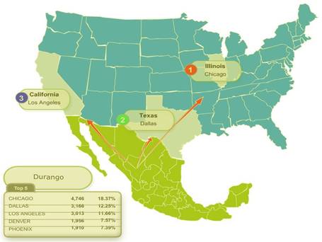
A Mexican government website, for its Institute for Mexicans Abroad, has lots of statistics about the number of Mexicans registered at each of Mexico’s consulates (which number more than 40) in the USA, together with their state of origin. A series of handy interactive maps for 2008, 2009 and 2010 provide a quick overview of some of the major flows.

  • Mexicans registered in consulates in the USA, 2008
  • Mexicans registered in consulates in the USA, 2009
  • Mexicans registered in consulates in the USA, 2010

Hovering your mouse over any state in Mexico brings up details of which consulates in the USA attracted the highest number of registrations for migrants who originated from that state.

Example of map

Example of migration map, courtesy of Dr. Seth Dixon

By way of illustration, consider the patterns shown using the 2010 map for migrants who originated in the three states (Campeche, Yucatán and Quintana Roo) forming the Yucatán Peninsula. It turns out that migrants from the state of Yucatán are far more concentrated than migrants from the other two neighboring states. About 60% of all migrants from the state of Yucatán who registered in Mexican consulates in the USA registered in either San Francisco, Los Angeles (both California) or Portland (Oregon).

For migrants from Campeche, the “top three” consulates are Omaha (Nebraska), Atlanta (Georgia) and Dallas (Texas), but these three account for only about 22% of all Campeche migrants registered with a consulate, meaning that the spread of migrants from Campeche is far less focused than that of migrants from Yucatán state.

In the case of Quintana Roo, the top three consulates for registrations are San Francisco (California), Atlanta (Georgia) and Dallas (Texas); these three account for almost 40% of all registrations of migrants from Quintana Roo.

Identifying a pattern, or variations between the patterns for several states is one thing; explaining it is another!

Q. What factors might influence the differences in patterns noted for the three states of the Yucatán Peninsula?

Aug 062011
 

The 2010 censuses in the USA and Mexico have led to numerous reports on either side of the border. This post looks mainly at recent reports from the Pew Hispanic Center, a project of Pew Research Center, which describes itself as”a nonpartisan ‘fact tank’ that provides information on the issues, attitudes and trends shaping America and the world.”

The total US population in 2010 was 308.7 million. The Pew report entitled U.S. Hispanic Country of Origin Counts for Nation, Top 30 Metropolitan Areas says the the USA had 50.5 million Hispanics in 2010, including 31.8 million of Mexican origin (63% of all Hispanics). [The categories are based on self-described family ancestry or place of birth in response to questions in the 2010 Census and the 2009 American Community Survey.] The population of Mexican-origin grew by 54% (11.2 million) between 2000 and 2010. Mexicans are the dominant Hispanic group in many major metropolitan areas, from Los Angeles to Chicago, and San Antonio to Atlanta, with some exceptions in the East, including Miami (Cubans) and New York (Puerto Ricans).

The report is accompanied by detailed statistical profiles, including Statistical Profile: Hispanics of Mexican Origin in the United States, 2009 that provides a concise summary of all the key data about the Mexican diaspora in the USA.

The Pew Hispanic Center has also updated its interactive maps and database on the USA’s Latino population. Data can be viewed by county for 1980, 1990, 2000 and 2009 and reveal the shifting patterns of residence of the Hispanic population since 1980.

Another Pew report, The Mexican-American Boom: Births Overtake Immigration shows that, since 2000, births have overtaken immigration as the main driver for the dynamic growth of the Mexican population in the USA. This is because:

  • Mexican-Americans are younger (on average) and have higher fertility than other US groups, and
  • The numbers of Mexicans migrating to the USA has fallen. Mexico’s 2010 census revealed that emigration from Mexico to the USA has dropped significantly in recent years, from an average of 480,000/year in 2000—2005 to around 145,000/year for 2005—2010.

Hispanics in the USA lag behind the rest of the population in terms of education. For example, only 9% of Mexicans in the USA aged 25 and over have at least a  Bachelor’s degree, compared with 13% of all Hispanics in the USA and over 20% for the US population as a whole. This is reflected in median earnings, where the average personal earnings for Mexicans in the USA aged 16 and over was $20,000 in 2009, compared to $28.900 for the US population as a whole.

A Presidential Advisory Commission has been formed to look at ways to improve the academic achievement of Hispanics, the largest and fastest-growing minority in the public education system.

The growing number of Hispanics in the USA has meant that Hispanics are now looking to have a greater say in politics. This has led to the formation of the Tequila Party, a nonpartisan movement launched on 5 May (Cinco de Mayo) 2011. Their first political rally, a call to “get out and vote”, accompanied by mariachis, was held in Tucson, Arizona.

Driving in Mexico: is it safe relative to other countries?

 Books and resources  Comments Off on Driving in Mexico: is it safe relative to other countries?
Jul 282011
 

About 24,000 people were killed last year in traffic accidents in Mexico according to Ángel Martínez, Director of the Mexican Traffic Safety Research Center (Spanish acronym CESVI) . In the USA, the number was about 33,000 in 2010. Does this mean that is safer to drive in Mexico than the USA?

The simple answer is “no” because the USA has three times as many people, about ten times as many registered vehicles, and probably drives over ten times as many vehicle-miles as Mexico. Comparing traffic deaths among countries is relatively complicated because the data are often lacking or not comparable.

A large 2009 World Health Organization (WHO) study indicates that traffic deaths are related to numerous factors. Obviously, the number, age, condition and mix of motor vehicles are very important. Two-wheeled motor vehicles can be more dangerous than automobiles, buses or trucks. Furthermore, road quality, traffic infrastructure, laws, and enforcement are major factors. Many countries do not require use of seat belts, helmets or child seats. The training, skill level and behavior of drivers, as well as pedestrians, are also important. Other factors are alcohol use by drivers and pedestrians, as well as the quality and efficiency of emergency medical teams and health care systems.

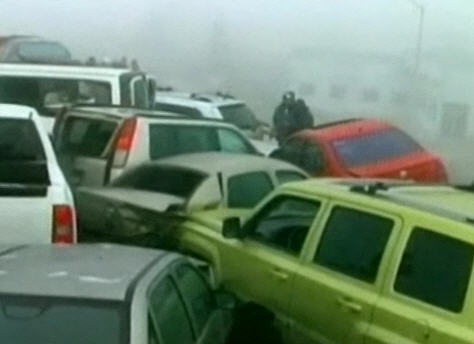
50-vehicle pile-up in fog, Saltillo, January 2011

50-vehicle pile-up in fog, Saltillo, January 2011

According to the WHO study, Mexico ranked 12th in the world in total traffic fatalities. China ranked first with 221,000 deaths per year, followed by India, Nigeria, Pakistan, Indonesia, Russia, Brazil, USA, Egypt, Ethiopia, Iran and then Mexico. Total deaths are related to population, number of vehicles and pedestrians, poor traffic control and emergency medical systems, as well as crowded roads shared by everything from trucks, buses, cars and motor bikes to livestock and pedestrians.

Mexico has about 21 traffic deaths per year per 100,000 population. This is a fairer way to compare countries. On this statistic, Mexico does slightly worse than Brazil (18), China (17), India (17), Indonesia (16), and Thailand (20). Though Mexico is slightly better than Peru (22), Venezuela (22), Russia (25), and Pakistan (25), considerable improvement is needed. President Calderón has set as a goal of reducing traffic deaths by 50% by 2020. Mexico is significantly behind some of the other Western Hemisphere countries such as Canada (9), USA (11), Argentina (14), Colombia (17) and even Guatemala (15).

The major countries with the safest traffic are Japan (5), UK (5), Germany (6), and France (8). The least safe countries are mostly in Africa and include Egypt (42), Ethiopia (35), Kenya (34), Nigeria (32), the Congo (32) and South Africa (33).

Wear your seat belt and drive safely!

Are Mexicans the world’s hardest-working people or the least productive?

 Books and resources  Comments Off on Are Mexicans the world’s hardest-working people or the least productive?
Jun 042011
 

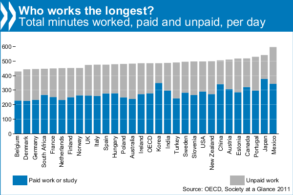
The headline — “Mexicans work longer hours than anyone else” — said it all, or did it? A recent report from the OECD (Organisation for Economic Co-operation and Development) found that Mexicans worked longer hours than people in any other OECD country, devoting 10 hours a day to paid and unpaid work (the latter includes housework and cooking). By contrast, Belgians work the least, only 7 hours. The OECD average is 8 hours a day. Is the positive spin simply because the OECD is currently headed by Mexican economist Dr. Angel Gurría?

The figures come from the latest edition of OECD’s Society at a Glance (2011), which gives an overview of social trends and policy developments in all member countries. Using indicators taken from OECD databases and other sources, it shows how societies are changing over time and how different countries compare.

Most unpaid work is housework. Mexicans do the most, more than 3 hours per day, and Koreans the least, only 79 minutes. Mexicans spend more time cooking than is customary in most other countries. The inhabitants of the USA spend the least time cooking each day, barely 30 minutes, and Turks the most, 74 minutes. Most people spend around 50 minutes a day cooking. Shopping also makes up a big part of unpaid work. The OECD average is 23 minutes a day, with the French spending the most (32 minutes) and the Koreans the least (13 minutes).

OECD: Working Hours

OECD: Working Hours

The report also attempts to estimate how much unpaid work is worth as a percentage of GDP for the 25 OECD countries for which data are available. It finds that the value of unpaid work is considerable, equivalent to about one-third of GDP in OECD countries, ranging from a low of 19% in Korea to a high of 53% in Portugal.

From a Mexican perspective, this may all paint a very rosy picture. However, as other commentators (see, for example, Burro Hall) have pointed out, it could equally well mean that Mexicans have the lowest productivity in the world, since they are working longer hours than other countries, but failing, in most sectors, to out-perform them!

Other highlights from the OECD’s Society at a Glance:

  • The 4 hours and 21 minute difference in unpaid work time between Mexican women and men is the largest in the OECD, where the average gap is 2 hours and 28 minutes
  • Mexicans have the second highest level of income inequality and the highest level of relative poverty in the OECD. One in every five Mexicans are poor, compared to just above one in ten on average across the OECD. Nearly half of Mexicans find it difficult or very difficult to get by on their current income.
  • Mexicans report the third highest positive psychological experiences (feeling rested, smiling, learning, and enjoyment) and lower than average negative experiences (pain, worry, stress, sadness, depression).

Review of Jeffrey M. Pilcher’s “¡Que vivan los tamales! Food and the making of Mexican Identity”

 Books and resources  Comments Off on Review of Jeffrey M. Pilcher’s “¡Que vivan los tamales! Food and the making of Mexican Identity”
Jun 022011
 

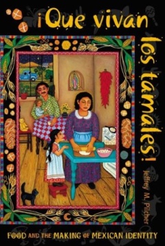
Are you interested in the geography of Mexico’s regional cuisines or the historical relationships between food preparation methods and gender roles in Mexican society? If so, add ¡Que vivan los tamales! Food and the making of Mexican Identity by Jeffrey Pilcher to your “Books Wanted” list.

Pilcher’s lively and entertaining account analyzes how the history of food in Mexico has been intimately tied to the country’s evolving national identity. The connections have become widely recognized, so much so that UNESCO recently conferred Intangible Cultural Heritage status on traditional Mexican cuisine, especially that of the state of Michoacán.

Pilcher cover of Que Vivan Los TamalesIn every chapter, Pilcher delves into the details. He explains how Mexico’s elites strongly preferred dishes based on wheat (first introduced into Mexico by early colonists) to those based on corn, one of Mexico’s many contributions to world cuisine. Indeed, they went so far as to argue that, across the globe, societies based on corn or rice would never rise above those based on wheat.

True appreciation of Mexico’s indigenous foods developed only slowly, mirroring the gradual development of nationalism, before coming to be considered a key component of the national identity. The advent of the railways in the 19th century allowed exotic foodstuffs to be marketed throughout the country for the first time. National cookbooks began to appear, highlighting the distinctive dishes of different regions, a trend continued to the present-day.

Technological developments have brought many changes. With industrialization, the time-consuming preparation of traditional corn tortillas was gradually superseded, especially in urban environments, by machine-made tortillas, whose taste is considered by connoisseurs to be greatly inferior to that of their hand-made equivalents, now increasingly restricted to relatively remote rural areas. Each step in the industrialization of tortillas brought massive social changes. Traditionally, the production of tortillas was the preserve of womenfolk, one of their numerous daily household chores. When mechanized tortilla presses were introduced, the making of tortillas quickly became an acceptable occupation for men. Freedom from the arduous work involved in making tortillas daily from scratch allowed women time to pursue other activities and to enter the formal workforce.

Gender, race, social class, dietary preferences, the fusion of indigenous cuisine and techniques with ingredients and methods imported from Europe and elsewhere… all are explored in this fascinating book.

Mexico’s cuisine is justly famous for its extraordinary regional variety; in just a few decades, the essential ingredients for Mexican food have become global commodities, appearing on supermarket shelves in dozens of countries around the world. Pilcher’s book puts this success in context, making it an essential read for anyone interested in the geography and history of Mexican cuisine.

Details (link is to amazon.com): ¡Que vivan los tamales! Food and the making of Mexican Identity by Jeffrey M. Pilcher (University of New Mexico Press, 1998).

Related posts:

For more about Mexican cuisine, visit the amazing award-winning blog Mexico Cooks! and also browse the huge selection of recipes, articles and tips about all aspects of Mexcan food and cooking in the “Cuisine” section of MexConnect. ¡Buen provecho!

Make your own “Better Life Index”

 Books and resources, Teaching ideas  Comments Off on Make your own “Better Life Index”
May 252011
 

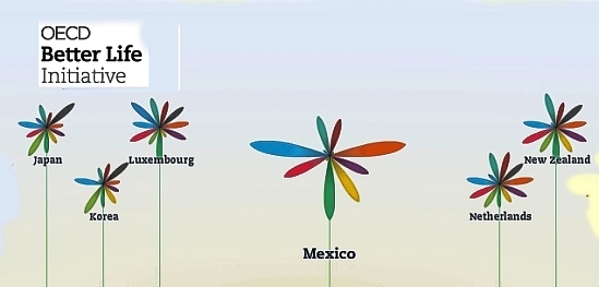
An interactive graph from the OECD (Organisation for Economic Co-operation and Development) now allows you to compile your own “Better Life Index” and compare “well-being” across the 34 member countries of the OECD. From an educational perspective, the graph offers hours of fun and fact-filled learning opportunities.

Better Life Index

The graph allows you to set individual weightings for each of 11 variables considered by the OECD to be important for well-being, and then see how the 34 countries rank on a graph. The graphs can be arranged either by rank or by country name. The 11 variables are:

  • housing
  • income
  • jobs
  • community
  • education
  • environment
  • governance
  • health
  • life satisfaction
  • safety
  • work-life balance

The symbols for each country are a flowers with 11 petals, one for each variable, where the length of the petal represents that country’s score and the width of the petal reflects the weighting you’ve given it.

This would be a great starting point for discussions of what “well-being” really means, and why different people (different countries?) would choose very different weightings for the 11 variables.

Related posts:

Various simple and compound development indices are discussed in chapters 29 and 30 of Geo-Mexico: the geography and dynamics of modern Mexico. Ask your local library to purchase a copy today!

Review of “Climate and Society in Colonial Mexico: A Study in Vulnerability” (Georgina Endfield)

 Books and resources  Comments Off on Review of “Climate and Society in Colonial Mexico: A Study in Vulnerability” (Georgina Endfield)
Apr 052011
 

Environmental historian Georgina Endfield has analyzed a wide variety of colonial archives to explore the complex relationships between climate and social and economic systems. Her book—Climate and Society in Colonial Mexico: A Study in Vulnerability—considers case studies in three distinct zones of Mexico:

  • the arid Conchos Basin of Chihuahua
  • the fertile Oaxaca Valley
  • the agricultural area centered on Guanajuato in the Bajío region

Endfield - Cover of Climate and Society in Colonial MexicoEndfield systematically unravels the connections between climatic vulnerability and the ways in which societies sought to mitigate the impacts of climate-related disasters, while striving for greater resilience against similar events in the future. Her book considers a range of disasters and impacts, from floods, droughts and storms to epidemics, food shortages, riots and rebellions.

The author captures her readers immediately as she describes how “28 June 1692 was a very wet day in Celaya, Guanajuato. Unusually heavy rains began falling in the afternoon and continued all through the evening.” This was the prelude to “terrible panic among all the inhabitants of the city”, and “could not have come at a worse time”, since two years of drought and crop blights had led to famines and epidemics.

Throughout the book’s seven chapters, Endfield writes in a direct manner. She avoids lengthy quotes in favor of presenting a carefully constructed argument, as she leads the reader in an exploration of the content and merits of the colonial sources. In the final chapter, she examines the broader context, relating climatic events in Mexico to events in Europe, and considering the possible role of ENSO (El Niño Southern Oscillation) events.

An extended table towards the end of the book provides a time line for the known environmental hazard events striking the three areas between 1690 and 1820. It shows, for example, that droughts were reported in Chihuahua in no fewer than 40 years of that 130-year time span.

Referencing throughout the book is meticulous, and repeated use is made easier by the provision of a detailed index.

I do have one tiny quibble. The use of accents in this book is quite inconsistent. Even for place names, some accents are missing, while others have migrated to the wrong letter. For example, Léon is often used for León.

This is a fascinating read. Apart from the many invaluable examples of climatic hazards and their demographic, social, economic and political impacts, Endfield has been hugely successful in demonstrating the tremendous value of Mexico’s rich colonial archives, archives which no doubt still hold many more secrets, which they will only give up in response to similarly painstaking research.

Studies of climate change are set to take center-stage in coming decades, and this historical account reminds us all that climate hazards are far from a rare or a novel occurrence.

In short, this is a highly recommendable book.

Details (click for amazon.com):

Climate and Society in Colonial Mexico: A Study in Vulnerability (Blackwell, 2008) by Georgina H. Endfield; 235 pages.

Mexico’s diverse climates and climatic vulnerability are the subject of chapter 4 of Geo-Mexico: the geography and dynamics of modern Mexico. Water availability, rivers, aquifers, water issues and hazards are analyzed in chapters 6 and 7. Buy your copy today!

An in-depth analysis of drug violence in Mexico from the University of San Diego’s Trans-Border Institute

 Books and resources  Comments Off on An in-depth analysis of drug violence in Mexico from the University of San Diego’s Trans-Border Institute
Mar 222011
 

The Trans-Border Institute (TBI) at the University of San Diego has published a very informative analysis of drug violence in Mexico which goes into far more depth than our short blog posts. The report is part of the TBI’s Justice in Mexico initiative, which is focused on crime, policing and the legal system in Mexico. The Justice in Mexico website provides public access to several books and working papers, databases and specially-drawn maps, produced by the project’s researchers.

Drug Violence in Mexico: Data and Analysis Through 2010, authored by Viridiana Ríos and David Shirk, takes a close look at both the patterns and trends relating to drug violence. The full text of the 21-page report (as a pdf file) is available here.

The report includes numerous maps showing the pattern by municipality for several successive years; when seen in sequence, the shifting focus of drug violence is clearly apparent. A large number of additional maps showing state-level values can be accessed from the Resources on Drug Violence page. These maps use total values for each state, whereas most of the maps and statistics we have included in previous posts (here, here and here) use rates/100,000 people.

Ríos and Shirk balance the bad news about the increase in drug violence in Mexico with their assessment that Mexico’s war against the drug cartels is beginning to show some signs of (limited) success. They point, for example, to the gaps created in the leadership structures of several cartels, due to the capture or killing of high-profile traffickers such as Teodoro “El Teo” García Simental, Edgar “La Barbie” Valdez and Nazario “El Chayo” Moreno.

The TBI report on drug violence includes a brief discussion of some of the  methodological issues connected to alternative and overlapping definitions, and to the various alternative sources of data. In particular, they consider the relative merits of official government figures and those compiled by Reforma, a national daily. Ríos and Shirk acknowledge that the recent provision of more comprehensive statistics by Mexico’s federal authorities represents a major improvement as regards transparency. Interestingly, the figures released by the government in January 2011 are far higher than those compiled by Reforma.

The TBI investigators are not alone in puzzling over the quality of the data for drug-related violence. A recent Spanish-language article elsewhere, by José Merino, compared the number of drug-war deaths recorded in the government figures to the total number of homicides (drug-related or not) in a database managed by INEGI, the National Statistics Institute, based on death certificates in each municipality. Merino identified 105 municipalities (out of 2,456 nationwide) where the total number of drug-related homicides appeared to be higher than the total number of all homicides. The most extreme case in Moreno’s comparison was the discrepancy of 199 homicides in the case of Culiacán, the capital of the state of Sinaloa. The INEGI database showed 1,104 homicides in total, while the federal government figure, for drug-related homicides only, was 1,303.

The history and scope of geography

 Books and resources  Comments Off on The history and scope of geography
Mar 012011
 

Dr Jerome Dobson, who led the Bowman Expedition to Mexico, gave the 2010 Jefferson Science Lecture to the US Department of State on “Geography: Use It Or Lose It“:

  • Full text of Geography: Use It Or Lose It” with link to video was at http://www.state.gov/e/stas/series/154218.htm [March 2011]

This lecture ranges widely across the history and scope of geography (primarily in the USA) and  is a very interesting read, as is Dobson’s earlier 2-part article in ArcNews:

(Thanks go to Dr. Joseph Kerski, Esri’s Education Manager, for suggesting the links to Dobson’s lectures.)

Mexico and USA agree to talk about oil rights in the Gulf of Mexico’s “Western Doughnut Hole”

 Books and resources, Mexico's geography in the Press  Comments Off on Mexico and USA agree to talk about oil rights in the Gulf of Mexico’s “Western Doughnut Hole”
Nov 152010
 

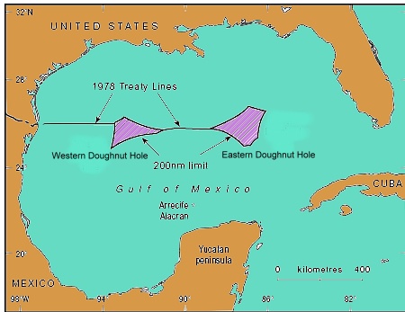
In 1970, the UN Law of the Sea Convention formally awarded each country the right to natural resources in its 200-mile (322 km) Exclusive Economic Zone (EEZ). Where claims overlapped, the Law of the Sea requires the competing countries to negotiate separate bilateral or multilateral agreements.

By 1979, the US and Mexico had agreed a treaty governing the basic delimitation of their respective EEZs. However, the treaty was never ratified by the US Senate. While the treaty had fixed seven points on the boundary, there were still two areas where the countries’ claims overlapped. The two portions were called the Western and Eastern Polygons (or Gaps), but were quickly nicknamed the Doughnut Holes. Together they straddle about 200 km of border.

The Western Doughnut Hole has a surface area of 17,467 square kilometers (6,744 square miles). The Eastern Doughnut Hole is about 20,000 square kilometers (7,720 square miles) and partially overlaps with the EEZ of Cuba.

location of doughnut holesTo date, no deposits of hydrocarbons have yet been found which straddle the maritime boundary, even though the Western Doughnut Hole is thought to hold untapped reserves of oil and gas. However, oil wells on one side of the boundary would likely extract some oil from the other side, hence the potential for conflict. In a parody of US politician Ross Perot’s famous 1992 line about the likely impact of the North American Free Trade Agreement (NAFTA) which would cause “a giant sucking sound” as US jobs moved south to Mexico, Mexican journalists have described the likely result of drilling in the Doughnut Hole as a “giant sucking sound” as US firms used their superior deep-water technology to suck up Mexican oil from the other side of the border.

Presidents Calderón and Obama agreed in May 2010 to extend the moratorium on any oil exploration drilling in the Western Polygon until January 2014, giving both sides time to hold joint discussions towards a permanent agreement.

The major oil spill from Deepwater Horizon has helped drive both governments to prioritize joint regulations governing oil and gas activities close to their shared border. Discussions are expected to cover not only deep water oil extraction, but also shallow water activities, including resources other than oil and gas.

For more details, see these two articles by Javier H. Estrada Estrada, Analitica Energética S.C.:

The changing political frontiers of Mexico are the subject of chapter 12 of Geo-Mexico: the geography and dynamics of modern Mexico. Oil reserves and exploitation are discussed in chapter 15.  If you have enjoyed this post, please consider purchasing a copy of Geo-Mexico so that you have your own handy reference guide to all aspects of Mexico’s geography.

Which states in Mexico are the most competitive in business terms?

 Books and resources, Teaching ideas  Comments Off on Which states in Mexico are the most competitive in business terms?
Nov 012010
 

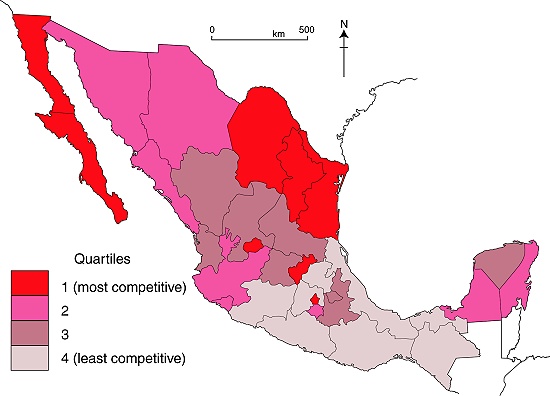
A recent report from the Mexican Institute for Competitiveness (Instituto Mexicano para la Competitividad, IMCO) provides some interesting insights into which areas of Mexico are “most competitive” in business terms. The latest report relies on 2008 data. The IMCO Competitiveness figures are usually compiled for a major urban area or a state, and international comparisons are also possible at the country level. For example, IMCO found that Mexico ranks 31st in the world for competitiveness, immediately behind Brazil, but ahead of China (rank 38). Mexico’s basic pattern of competitiveness at the state level is shown in the map.

IMCO defines competitiveness as the capacity to attract and retain investment and talent. This suggests a business environment that maximizes the socio-economic potential of both the business entities and individuals residing in a a specific area. It also suggests that any improved well-being (economic and social) will be maintained (sustained).

Map of competitiveness in Mexico, 2008

Competitiveness in Mexico, 2008. Map: Tony Burton; all rights reserved

The IMCO index of competitiveness is based on 120 key variables, grouped into 10 major factors affecting competitiveness. All the variables must be ones which are regularly updated and easy to interpret, with transparent methods of calculation. The 10 major factors include the reliability and objectivity of the legal system, the sustainable management of the natural environment, the stability of macroeconomic policies, the degree to which society is non-divisive, educated and healthy, and the stability and functioning of the political system.

  • Using the map above, how would you describe the pattern of competitiveness in Mexico? (north/south? coastal/inland?, proximity to the USA?)
  • Does the pattern of competitiveness match the pattern of GDP/capita? In what way is the State of Mexico an anomaly in this regard? Are there other anomalies?

A full analysis of why some states are more competitive than others is beyond the scope of this post. However, given its relevance to geographers, we will examine the specific variables that make up the sustainable management of the natural environment in a future post, when we will also take a look at the trends for that indicator.

Mexico’s economy and workforce are analyzed in chapters 14 to 20 of Geo-Mexico: the geography and dynamics of modern Mexico. Ask your library to buy a copy of this handy reference guide to all aspects of Mexico’s geography today! Better yet, order your own copy…

Oct 222010
 

By common consent, the history of blacks in what-is-now Mexico is a long one. The first black slave to set foot in Mexico is thought to have been Juan Cortés. He accompanied the conquistadors in 1519. It has been claimed that some natives thought he must be a god, since they had never seen a black man before.

A few years later, six blacks are believed to have taken part in the successful siege of the Aztec capital Tenochtitlan. Several hundred other blacks formed part of the wandering, fighting forces employed in the name of the Spanish crown to secure other parts of New Spain.[1]

The indigenous population crashed in the first hundred years following the conquest, largely as a result of smallpox and other European diseases. Estimates of the native population prior to the conquest range from 4 to 30 million. A century later, there were just 1.6 million.
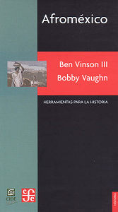
afromexico-coverNew Spain had been conquered by a ludicrously small number of Spaniards. To retain control and in order to begin exploiting the potential riches of the virgin territory they had won, a good supply of laborers was essential. There were not enough locals, so imports of slaves became a high priority.

By 1570, almost 35% of all the mine workers in the largest mines of Zacatecas and neighboring locations were African slaves. [2] Large numbers of slaves were also imported for the sugar plantations and factories in areas along the Gulf coast, such as Veracruz. By the mid-seventeenth century, some 8,000-10,000 blacks were Gulf coast residents. After this time, the slave trade to Mexico gradually diminished.

Miguel Hidalgo, the Independence leader, first demanded an end to slavery in 1810 (the same year that Upper Canada freed all slaves). Slavery was abolished by President Vicente Guerrero on September 15, 1829.

During the succeeding 36 years, prior to the abolition of slavery in the U.S. (1865), some U.S. slaves seized their chance and headed south in search of freedom and opportunity. Recognizing the potential, in 1831, one Mexican senator, Sánchez de Tagle, a signatory of the Act of Independence, called for assistance to be given to any blacks wanting to move south on the grounds that this movement would possibly prevent Mexico being invaded by white Americans. [3] Sánchez de Tagle’s point was that black immigrants would be strong supporters of Mexico since they wouldn’t want to be returned to slavery, and would be preferable to white Americans, who might be seeking an opportunity to annex parts of Mexico for their homeland. Sánchez de Tagle’s fears came to pass. One year after the U.S. annexed the slave-holding Republic of Texas in 1845, it invaded Mexico.

Perhaps as many as 4,000 blacks entered Mexico between 1840 and 1860. At the beginning of 1850, several states enacted a series of land concessions for black immigrants, in order that undeveloped areas with agricultural potential might be settled and farmed.

Even after the abolition of slavery in the U.S., small waves of blacks continued to arrive periodically in Mexico. Many came from the Caribbean after 1870 to help build the growing national railway network. In 1882, some 300 Jamaicans arrived to help build the San Luis Potosí-Tampico line; another 300 Jamaicans made the trip in 1905 to take jobs in mines in the state of Durango. [4] Partially as a response to their own independence struggles, thousands of Cubans came after 1895. They favored the tropical coastal lowlands such as Veracruz, Yucatan and parts of Oaxaca, where the climate and landscapes were more familiar to them than the high interior plateaux of central Mexico.

Mexican historians have largely ignored the in-migration of blacks and their gradual intermarriage and assimilation into Mexican society. For a variety of reasons, they chose to focus instead on either the indigenous peoples, or the mestizos who form the majority of Mexicans today. The pendulum is finally beginning to swing back, as researchers like Charles Henry Rowell, Ben Vinson III and Bobby Vaughn re-evaluate the original sources, and examine the life and culture of the communities where many blacks settled.

Most work about the influence of blacks on modern-day Mexico has focused on the Veracruz area, in particular on the settlements of Coyolillo, Alvarado, Mandinga and Tlacotalpan. 5 On the opposite coast, Bobby Vaughn has spent more than a decade studying the Costa Chica of Oaxaca and Guerrero. [6]

Analysts of Mexican population history emphasize the poor reliability of early estimates and censuses, as well as the complex mixing of races which occurred with time. While the precise figures and dates may vary, most demographers appear to agree with Bobby Vaughn that the black population, which rose rapidly to around 20,000 shortly after the conquest, continued to exceed the Spanish population in New Spain until around 1810.

It is estimated that more than 110,000 black slaves (perhaps even as many as 200,000) were brought to New Spain during colonial times. Happily, their legacy is still with us, and lives on in the language, customs and culture of all these areas.

Sources / Further Reading

1 Matthew Restall. Seven Myths of the Spanish Conquest. (Oxford University Press) 2003

2 Peter J. Bakewell. Silver Mining and Society in Colonial Mexico: Zacatecas, 1546-1700, cited in Afroméxico.

3 Vinson III, Ben & Vaughn, Bobby. Afroméxico. (in Spanish; translation by Clara García Ayluardo) Mexico: CIDE/CFE. 2004. The main source for this column, divided into three parts. Following a joint introduction, Ben Vinson III, Professor of Latin American History at Penn State University, provides a detailed overview of studies connected to blacks in Mexico. Then Bobby Vaughn, who has a doctorate in anthropology from Stanford University, adopts an ethnographic perspective in writing about the Costa Chica of Oaxaca and Guerrero; his short essay includes discussion of the Black Mexico movement. The work concludes with an extensive bibliography of sources relating to Afroméxico.

4 Vinson III, Ben & Vaughn, Bobby. Afroméxico. Mexico: CIDE/CFE. 2004

5 See, for example, the Winter 2004 and Spring 2006 issues of Callaloo (A Journal of African Diaspora Arts and Letters). The Spring 2006 issue, vol 29, #2, pp 397-543, has a series of articles under the general heading of “Africa in Mexico”, including transcriptions of fascinating interviews with such characters as Rodolfo Figueroa Martinez, who relates the history of how several local towns, including San Lorenzo de los Negros (now Yanga) were founded by blacks, and of how a black identity gradually emerged. Other interviewees discuss how they view their color and Afromestizo identity, lamenting the fact that their history has been distorted or largely forgotten. Local food and festival celebrations are also highlighted.

6 Bobby Vaughn’s Black Mexico Home Page, Afro-Mexicans of the Costa Chica, available via MexConnect, provides links to several of his articles including Blacks in Mexico. A Brief Overview.

Original article on MexConnect
Several chapters of Geo-Mexico: the geography and dynamics of modern Mexico discuss population issues, including population growth, distribution and density. Buy your copy today to have a handy reference guide to all major aspects of Mexico’s geography!

New irrigation areas in Chihuahua, Mexico, are visible from space

 Books and resources  Comments Off on New irrigation areas in Chihuahua, Mexico, are visible from space
Oct 212010
 

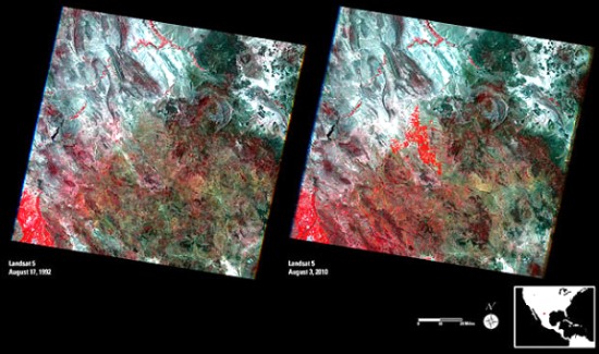
A recent article on Wired.com drew my attention to these spectacular Landsat photos of Chihuahua, Mexico.

Landsat images of Chihuahua

  • Link to high resolution Landsat images (clicking on the images in this link reveals amazing detail)

These false-color remote sensing images were taken by the Landsat 5 satellite in August 1992 (left) and August 2010 (right).

  • Red = vegetation (the brighter the red, the healthier the vegetation)
  • Whites, greens, browns = areas with bare soil or only limited vegetation (colors depend on organic matter and moisture content)
  • Blue & Black = water (clear, deep water is darker; sediment-laden water is lighter)
  • Blue-Gray = urban areas

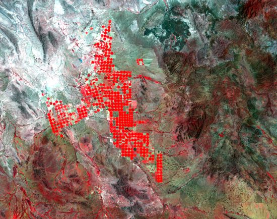
They show some interesting changes have taken place in the 18 years since the first image was captured. In particular, they reveal that more water is now available from a major reservoir, and is being used for irrigation. Particularly noticeable is the development of round irrigation areas in the central part of the images. These circular areas, which show as bright, red circles (see image below) are the result of center-pivot irrigation systems. The water is being used for growing alfalfa and sorghum to feed livestock.

Circular irrigation areas

Circular irrigation areas (enlarged view of center portion of 2010 image)

In addition to the impacts resulting from irrigation, diverting more water from the reservoir has also affected the area’s native vegetation, and reduced the amount of water flowing into the Río Grande River. This may have ameliorated, at least slightly, the serious flooding which occurred earlier this year in the same general area.

Mexico at Expo 2010 Shanghai

 Books and resources, Mexico's geography in the Press  Comments Off on Mexico at Expo 2010 Shanghai
Oct 182010
 

Expo 2010 Shanghai is the largest ever universal exhibition. Its theme is “Better City, Better Life”. The Expo has brought together more than 190 countries and 50 international organization. Each country has its own pavilion in Expo 2010.

At the Mexican pavilion in Expo 2010 Shanghai, this week (October 18–22) is Environment Week. Buried in the website for Mexico’s pavilion is a video section entitled “Past and present in Mexico’s Cities”. [Sadly, the link at http://shanghai2010.unam.mx/ssize/ext/?eje=migracion&lang=en no longer works]. While navigation in this section is far from intuitive, it is well worth spending some time wandering around this labyrinth of riches, even if only by trial and error. There are some excellent short written descriptions in English of a wide range of topics, from Aztec chinampas (mud “islands” separated by canals) to urban growth in the 19th century to future directions for Mexico’s cities.

Here’s hoping that the in-depth resource, apparently the work of UNAM, the National University, continues to be available after Expo 2010 closes at the end of the month.

In Geo-Mexico: the geography and dynamics of modern Mexico, chapters 21 and 22 analyze Mexico’s 500-year transition to an urban society and the internal geography of Mexico’s cities. Chapter 23 looks at urban issues, problems and trends. To preview more parts of the book, click here and use amazon.com’s “Look Inside” feature. Buy your copy today!

Some of Geo-Mexico’s favorite blogs and websites about Mexico

 Books and resources  Comments Off on Some of Geo-Mexico’s favorite blogs and websites about Mexico
Oct 072010
 

Geo-Mexico regularly scans a massive list of Mexico-related websites and blogs. Here are some of our favorite English language blogs and websites related to Mexico, in approximate alphabetical order. With few exceptions, we have excluded any blogs that are of only local or regional interest.

Blogs written in English:

  • Across the Border – former journalist comments on border issues and travel
  • Burro Hall – an irreverent look at life in Mexico (blog ended in 2014)
  • David Lida: Mostly Mexico City – well-known journalist’s colorful vignettes of customs, characters and places
  • Intersections – short opinion pieces with a more youthful perspective
  • Kristin Brickerjournalist offers detailed analysis of breaking news stories, especially those related to social movements and drug wars
  • Mexican Business Newscomprehensive business news with links to sources
  • Mexico Cooks! – authoritative and entertaining site about all aspects of Mexican cuisines
  • Mexico Reporter multimedia coverage of news and major issues
  • Our Year in Mexico – an artist’s fine photos of his Mexican travels
  • Sparks Mexico Web – a personal travel blog with photos and lists of regional blogs
  • The Mex Files personal commentary on history, art and politics
  • The Mexico Reporta journalist’s views on travel, culture and community
  • The Real Tijuana – news and information for tourists and residents

Websites or on-line magazines in English:

Fascinating new book about the Colorado River

 Books and resources, Excerpts from Geo-Mexico, Maps  Comments Off on Fascinating new book about the Colorado River
Aug 162010
 

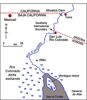
The Río Colorado formed a vast delta in the otherwise arid Sonoran desert in northern Mexico where it enters the Sea of Cortés (Gulf of California, see map.) The delta wetlands created ideal conditions for a rich variety of wildlife. The river enters Mexico at the Southerly International Boundary where a gauging station records the river’s discharge. This river is one of the most altered river systems in the world.

Map of the Colorado delta

Map of the River Colorado delta. All rights reserved.

The amount of water reaching Mexico has declined dramatically as a result of the Hoover and Glen Canyon dams and other diversions of Colorado River water in the USA. The few years of higher flows in the 1980s coincide with flood releases from US dams when they had been filled by heavy rains.

The river’s drastically reduced annual discharge violates a 1944 treaty under which the USA guaranteed that at least 1750 million cubic meters would enter Mexico each year via the Morelos diversionary dam in the Mexicali Valley. The Río Colorado wetlands have been reduced to about 5% of their original extent, and the potential water supply for the rapidly-growing urban centers of Mexicali, Tijuana, Tecate and Rosarito has been compromised.

The map and description above come from Geo-Mexico: the geography and dynamics of modern Mexico.

If you are interested in learning more about this river, a great place to start is the recently published book about the Colorado River called Running Dry: A Journey From Source to Sea Down the Colorado River (Jonathan Waterman; National Geographic Books, 2010). Waterman hiked and paddled the length of the river from the Rocky Mountain National Park to its delta in the state of Baja California, Mexico.

For excerpts from the book, see Running Dry on the Colorado and Mighty Colorado River dribbles through Mexico.

Peter McBride, a photographer, accompanied Waterman on his two year trek. His evocative photographs will appear in the book The Colorado River: Flowing Through Conflict (Westcliffe Publishers), due out in September. See Down the Colorado (slideshow) for some examples of his Colorado River photos.

Rivers, reservoirs and water-related issues are discussed in chapters 6 and 7 of Geo-Mexico: the geography and dynamics of modern Mexico. Ask your library to buy a copy of this handy reference guide to all aspects of Mexico’s geography today! Better yet, order your own copy…

Geo-Mexico is reader-supported. Purchases made via links on our site may, at no cost to you, earn us an affiliate commission. Learn more.

Bringing place names to life in Mexico City

 Books and resources  Comments Off on Bringing place names to life in Mexico City
Aug 022010
 

I love gifts, especially books, and especially when they are related to the geography of Mexico!

So, it was a doubly pleasant surprise recently to receive a copy of Glifos de la ciudad de México by Pablo Moctezuma Barragán (Gobierno del Distrito Federal, 2006; 103 pp.)

The author is an accomplished researcher, historian and politician who holds a teaching position at the Azcapotzalco campus of the Universidad Autónoma Metropolitana, and who spearheaded a campaign in Mexico City to bring the meanings of place names to life.

Atocpan = "On fertile soil"

Atocpan = "On fertile soil"

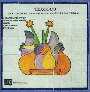
The project involved the installation around the city in 2006 of more than 300 works of art, all using traditional Talavera tiles, depicting pre-Hispanic glyphs, together with a brief explanation of their derivation and meaning. Each mosaic of 25 tiles measures one meter by one meter.  The vast majority of the glyphs are depicted as they are known in ancient codices or other historic sources, but in a few cases, glyphs have been specially created, faithfully reflecting  the ancient principles. Glifos de la Ciudad de México is a handy pocket guide to these glyphs.

The obligatory introductory statements by politicians are mercifully brief, though significantly for us, they do refer to the fact that many names depend on a circunstancia geográfica (a geographical circumstance) or are related to activities undertaken by the early settlers or to characteristic plants or animals. How encouraging to see such a tribute to geography!

Next comes a very interesting essay by Pablo Moctezuma Barragán, setting the scene for the full color illustrations of hundreds of glyphs which follow. The author discusses the origins of place name glyphs (the oldest date back 2500 years), and emphasizes that many reflect the importance of local geographic conditions. The forces of globalization may be at work in what is arguably the world’s largest city, but “It is important to rescue our roots”, argues Moctezuma Barragán, “We should not live like foreigners in our own land”.

He goes on to summarize the Nahuatl roots of many of the names and gives a potted history of the development of Mexico City.

Tile mosaic depicting glyph of Texcoco

Tile mosaic depicting glyph of Texcoco ("in the place where plants grow on rocks") on a wall in Mexico City. Credit: Glifos de la ciudad de México.

All the glyphs refer to names used somewhere in the city and many photographs show the commemorative tiled versions in situ in the city. In all, 322 glyphs were installed, and more than 220 of them are included in this book.

This is but one example of the many projects undertaken by Mexico City authorities in recent years to beautify the city.

What a neat idea, to introduce people, even as they go about their daily lives, to pre-Hispanic symbolism as it relates to local place names. These tiled works of art are a great way to encourage a sense of place and identity. They are not only beautiful, they serve to foment local pride.  Geography is alive and well in Mexico City!

Related website.

Several hundred ancient glyphs, from Antonio Peñafiel’s 1885 “Nombres Geográficos de México,” can be viewed online as part of the Aztec Place Name Glyphs Project of the Department of Geography at the University of California, Berkeley.

Previous posts about Mexico’s place names:

Review of “One Hundred and One Beautiful Small Towns in Mexico”.

 Books and resources  Comments Off on Review of “One Hundred and One Beautiful Small Towns in Mexico”.
Jul 302010
 

In an earlier post, we listed the towns included in One Hundred and One Beautiful Small Towns in Mexico, by Guillermo García Oropeza and Cristóbal García Sánchez (Rizzoli International Publications, 2008; 280 pp.). Here we offer a short review of the book.

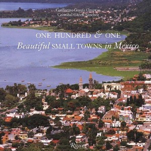
Cover of 101 Beautiful Small Towns in MexicoThis is a large format book, with many magnificent photographs. A fascinating range of places is included, even though the criteria used for their selection are nowhere explained. The selection offers lots of interest for anyone curious about Mexico’s geography.

For example, a stunning aerial view of Mexcaltitán (Nayarit) shows the cross-and-concentric-circle street pattern of “Mexico’s Venice”, surrounded by muddy brown shrimp-bearing swamps.

Curiously, the list of places included in the book on the contents pages adopts the affected style of using no capital letters whatsoever for any of the town names.

Each place is afforded at least a double page spread, and the back of the book has helpful lists of tourist offices, and selected hotels and restaurants.

Despite the title, some of the locations are more to do with the natural environment than with settlement. For instance, the town of Cuatro Ciénegas is a somewhat unprepossessing place whereas the desert oases of Cuatro Ciénegas,on which the book entry focuses, are an amazing natural zoological laboratory of crystalline water and extraordinary biodiversity. Similarly, Cacahuamilpa Caverns hardly qualify as a town!

The San Ignacio entry focuses on difficult to reach cave paintings. The village itself has few claims to fame beyond its colonial mission church.

The Paricutín double-page spread is named after the volcano which devoured several small settlements including Parícutin (for the name of the original village, the accent is on the second syllable; for the volcano it is on the last syllable). The photos included here actually show (as the captions make clear) the towns of Angahuan, and the upper facade of the church of San Juan Parangaricutiro, overwhelmed by the volcano’s lava.

A couple of places are given names that might not be very familiar to their residents. Casas Nuevas (Chihuahua) is actually Nuevo Casas Grandes (the real Casas Nuevas is an entirely different place which had only 13 inhabitants at the time of the 2000 census) and Mineral del Monte (Hidalgo) is more usually known as Real del Monte.

In southern Mexico, Santa María del Tule gets an entry. Santa María would not be worthy of mention, except for the fact that it is home to what is arguably the world’s largest tree, now thankfully restored to good health after decades of neglect.

In the Yucatán, three entries ignore the main thrust of the book, and focus instead on significant routes, one linking henequen (sisal) haciendas, one combining relatively minor archaeological sites which share distinctive Puuc architecture, and one going from one friary (monastery) to another. These are all interesting trips, but are entirely unexpected in a book specifically about towns. Some judicious editing might have removed some of the inaccuracies such as describing hemp (sisal) as “in the agave… or cactus, family”. The family name for agaves is Agavaceae which includes the genus Agave. In any event, agaves are biologically distinct to all members of the Cactaceae family; confusing agaves with cacti is an unexpected blunder.

The chosen towns quite rightly include some long-abandoned sites such as Teotihuacan, “City of the Gods”, which was once a city of 200,000 or so, the fascinating Mayan sites of Palenque and Chichen Itza, and Mitla and Monte Alban, both in Oaxaca.

The cover photo of the town of Chapala in Jalisco, much favored by American and Canadian retirees in recent years, unfortunately dates from a time when the lake level was relatively low. The green areas in the lake are floating masses of the introduced aquatic weed water hyacinth.

Despite being written by a Mexican historian, there are numerous minor historical inaccuracies in the text, though these should not detract from the enjoyment of the average reader.

For instance, in the Chapala entry, illustrated by the same photo used on the cover, it should be Septimus Crowe (not Crow), and the “navigation company with two small steam ships” had nothing to do with Christian Schjetnam. The steamships predated his arrival in Chapala by many years. Schjetnam did however, introduce two small sail yachts to the area, perhaps explaining the confusion. The description of President Díaz’s interest in Chapala appears to imply that he was first acquainted with the lake when he visited “a political crony” in 1904. Actually, Díaz was certainly personally familiar with Lake Chapala from long before this.

The entry for Santa Rosalia repeats the long-held but unproven idea that the main church was designed by Frenchman Gustave Eiffel (of Eiffel Tower fame). The town does have other Eiffel connections, and the church may indeed have been brought lock, stock and barrel from the 1889 Paris World Exhibition. However, research by Angela Gardner strongly suggests that the original designer was probably not Eiffel but was far more likely to have been Brazilian Bibiano Duclos, who graduated from the same Parisian academy as Eiffel. Gardner proved that Duclos took out a patent on prefabricated buildings, whereas she could find no evidence that Eiffel had ever designed a prefabricated building of any kind. Regardless of who designed it, it is certainly a unique design in the context of Mexico, and well worth seeing.

And really, surely this is the main point of this book. It was presumably never intended to be a reliable geographical (or historical) primer, but rather an enticing selection of seductive places, many of which will be unfamiliar to any but the most traveled reader. The variety of places included is breathtaking; few countries on earth can possibly match it. As such, One Hundred and One Beautiful Small Towns in Mexico is a resounding success.

This beautifully illustrated book should certainly tempt readers to venture into new parts of Mexico in search of these and other memorable places. Enjoy your travels!

– – – –

Mexico’s cities and towns are analyzed in chapters 21, 22 and 23 of Geo-Mexico: the geography and dynamics of modern Mexico. Buy your copy today!!

Jul 242010
 

According to the book One Hundred and One Beautiful Small Towns in Mexico, by Guillermo García Oropeza and Cristóbal García Sánchez (Rizzoli International Publications, 2008; 280 pp), these places all merit inclusion in the list of the 101 Beautiful Small Towns in Mexico.

Cover of 101 Beautiful Small Towns in MexicoWe will review the book more formally in a future post, since it offers some insights into Mexico’s geography, but for now take a look at the list below, and see if you agree.

Our own list of the most beautiful small towns would certainly include most of these, though we can think of some equally excellent choices which are not included.

Are there other towns that would be on your list? If so, let’s hear about them!

BAJA CALIFORNIA

  • San Felipe
  • Valle de Guadalupe

BAJA CALIFORNIA SUR

  • Loreto
  • Mulegé
  • San Ignacio
  • San Jóse del Cabo
  • Santa Rosalía
  • Todos Santos

CAMPECHE

  • Campeche
  • Edzná

CHIAPAS

  • Comitlán de Domínguez
  • Chiapa de Corzo
  • Palenque
  • San Cristóbal de las Casas
  • Yaxchilán
  • Bonampak
  • Zinacantán
  • San Juan Chamula

CHIHUAHUA

  • Batopilas
  • Creel
  • Hidalgo del Parral
  • Nuevas Casas [Nuevo Casaas Grandes]
  • Mata Ortíz
  • Cuarenta Casas

COAHUILA

  • Cuatro Ciénegas
  • Parras

COLIMA

  • Cómala

FEDERAL DISTRICT

  • Coyoacán

GUANAJUATO

  • Atotonilco
  • Dolores Hidalgo
  • Guanajuato
  • San Miguel De Allende
  • Yuriria

GUERRERO

  • Cacahuamilpa
  • Taxco

HIDALGO

  • El Chico
  • Huasca
  • Mineral del Monte [Real del Monte]
  • Tula

JALISCO

  • Chapala
  • Ajijic
  • Lagos de Moreno
  • Mazamitla
  • Puerto Vallaría
  • San Sebastián del Oeste
  • Tapalpa
  • Tequila
  • Tlaquepaque

MEXICO STATE

  • Malinalco
  • Teotihuacán
  • Acolman
  • Tepotzotlán
  • Valle De Bravo

MICHOACÁN

  • Angangueo
  • Cuitzeo
  • Paricutín
  • Angahuan
  • Santiago Nurío
  • Paracho
  • Pátzcuaro
  • Santa Clara del Cobre
  • Zirahuén
  • Tlalpujahua
  • Tzintzuntzan

MORELOS

  • Cuernavaca
  • Tepoztlán
  • Tétela del Volcán
  • Xochicalco
  • Yecapixtia

NAYARIT

  • Mexcaltitán

NUEVO LEÓN

  • Bustamante
  • Villa de García

OAXACA

  • Cuilapan
  • Arrasóla
  • Ixtlán De Juárez
  • Mitla
  • Monte Albán
  • Ocotlán
  • San Bartólo Coyotepec
  • Santa María del Tule
  • Tlacochahauya
  • Tlacolula
  • Dianzú
  • Yanhuitlán

PUEBLA

  • Cuetzalan
  • Cholula
  • Huejotzingo
  • Tonantzintia
  • San Francisco Acatepec

QUERÉTARO

  • Bernal
  • Jalpan

QUINTANA ROO

  • Bacalar
  • Cozumel
  • Holbox
  • Isla Mujeres
  • Playa del Carmen
  • Tulum

SAN LUIS POTOSÍ

  • Real de Catorce

SINALOA

  • Cósala

SONORA

  • Alamos
  • Magdalena de Kino

TLAXCALA

  • Tlaxcala

YUCATAN

  • Chichen Itza
  • Izamal
  • Uxmal
  • Valladolid

VERACRUZ

  • Coatepec
  • Los Tuxtlas
  • Papantia
  • Tlacotalpan

ZACATECAS

  • Guadalupe
  • Jerez
  • Sombrerete

Mexico’s cities and towns are analyzed in chapters 21, 22 and 23 of Geo-Mexico: the geography and dynamics of modern Mexico. Buy your copy today!!

Mexico City’s wholesale food market, Central de Abasto

 Books and resources, Other  Comments Off on Mexico City’s wholesale food market, Central de Abasto
Jul 072010
 

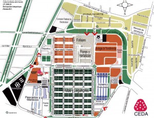
Have you ever wondered how food supplies are organized in a metropolitan area the size of Mexico City (population 20 million) so that all its inhabitants have regular access to fresh produce? Like most major world cities, Mexico City has a specialized wholesale market for food, Central de Abasto. It is located in Iztapalapa, south-east of the city center.

Nicola Twilley, a freelance writer currently based in Montreal, has written a wonderfully informative description of what a visit to the Central de Abasto is like on her fascinating blog edible geography

Map of Central de Abasto, Mexico City

Map of Central de Abasto, Mexico City. Click to enlarge.

The map is the “official” map of the Central de Abasto in all its glory. While I often organized market surveys for school groups in Mexico, I have to admit that I never dared take on the challenge of surveying the Central de Abasto. This map, and Twilley’s fun account of the market reminds me why I never had the courage!

Mexican markets, in all their guises, from the massive Central de Abasto down to a humble tianguis (street market) in a small village, are a fascinating aspect of Mexico’s geography, and well worth a book in their own right.

Enjoy!

Notes:

The introduction of sheep caused widespread environmental damage in Mexico

 Books and resources, Excerpts from Geo-Mexico  Comments Off on The introduction of sheep caused widespread environmental damage in Mexico
Jul 032010
 

After the conquest, Spanish settlers introduced numerous Old World species into the New World. The most pernicious introductions were human-borne diseases, which led to the rapid and tragic decimation of the indigenous population. However, most of the introductions were deliberate, made with the intention of increasing the diversity of available food and resources. Among the non-native (exotic) plants and animals introduced were sheep, pigs, chickens, goats, cattle, wheat, barley, figs, grapevines, olives, peaches, quinces, pomegranates, cabbages, lettuces and radishes, as well as many flowers.

The environmental impact of all these introductions was enormous. The introduction of sheep to Mexico is a case in point.

In the Old World, wool had been a major item of trade in Spain for several centuries before the New World was settled. The first conquistadors were quick to recognize the potential that the new territories held for large-scale sheep farming.

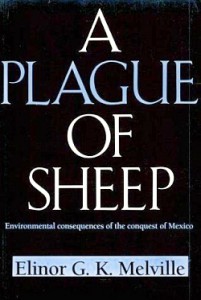
Cover of A Plague of SheepThe development of sheep farming and its consequences in one area of central Mexico (the Valle de Mezquital in Hidalgo) was analyzed  by Elinor Melville in A Plague of Sheep. Environmental Consequences of the Conquest of Mexico.

Melville divides the development of sheep farming in the Valle of Mezquital into several distinct phases. Sheep farming took off during Phase I (Expansion; 1530-1565). During this phase, the growth in numbers of sheep in the region was so rapid that it caused the enlightened Viceroy, Luis de Velasco, to became concerned that sheep might threaten Indian land rights and food production. Among the regulations introduced to control sheep farming was a ban on grazing animals within close proximity of any Indian village. At first the Indians did not own any grazing animals, and consequently did not fence their fields, which inadvertently encouraged the Spaniards to treat the landscape as common land.

During Phase II (Consolidation of Pastoralism; 1565-1580), the area used for sheep grazing remained fairly stable, but the numbers of sheep (and therefore grazing density) continued to increase. By the mid-1570s, sheep dominated the regional landscape and the Indians also had flocks. One of the consequences of this was environmental deterioration to the point where by the late 1570s, some farmers did not have adequate year-round access to pastures and introduced the practice of seasonal grazing in which they moved their flocks (often numbering tens of thousands of sheep) from their home farm in central Mexico to seasonal pastures near Lake Chapala.

This practice of grazing on harvested fields or temporary pastures was known as agostadero. This term originally applied to summer (agosto=August) grazing in Spain but was adopted in New Spain for “dry season” grazing, between December and March. So important was this annual movement of sheep that provision was made in 1574 for the opening of special sheep lanes or cañadas along the route, notwithstanding the considerable environmental damage done by the large migrating flocks. As flock sizes peaked, more than 200,000 sheep made the annual migration by 1579.

In the words of historian Francois Chevalier:

By 1579, and doubtless before, more than 200,000 sheep from the Querétaro region covered every September the 300 or 400 kilometers to the green meadows of Lake Chapala and the western part of Michoacán; the following May, they would return to their estancias.

The prime dry season pastures were those bordering the flat, marshy swampland at the eastern end of Lake Chapala. The Jiquilpan district alone supported more than 80,000 sheep each year, as the Geographic Account of Xiquilpan and District (1579) makes clear:

More than eighty thousand sheep come from other parts to pasture seasonally on the edge of this village each year; it is very good land for them and they put on weight very well, since there are some saltpeter deposits around the marsh.

By the end of Phase III (The Final Takeover; 1580-1600), most land had been incorporated into the Spanish land tenure system, the Indian population had declined (mainly due to disease) and the sheep population had also dropped dramatically. Contemporary Spanish accounts reveal that this collapse was attributed to a combination of the killing of too many animals for just their hides by Spaniards, an excessive consumption by Indians of lamb and mutton, and by the depletion of sheep flocks by thieves and wild dogs. Melville’s research, however, suggests that the main reason for the decline was actually environmental degradation, brought on by the excessive numbers of sheep at an earlier time.

The entire process is, in Melville’s view, an excellent example of an “ungulate irruption, compounded by human activity.” The introduction of sheep had placed great pressure on the land. Their numbers had risen rapidly, but then crashed as the carrying capacity of the land was exceeded. The carrying capacity had been reduced as (over)grazing permanently changed the local environmental conditions.

By the 1620s, the serious collapse in sheep numbers in the Valle de Mezquital was over; sheep farming never fully recovered. The landscape had been changed for ever.

Sources / Further reading:

  • Acuña, R. (ed) Relaciones geográficas del siglo XVI: Michoacán. Edición de René Acuña. Volume 9 of Relaciones geográficas del siglo XVI. Mexico City: Universidad Nacional Autónoma de México. 1987
  • Chevalier, F. Land and Society in Colonial Mexico. University of California Press. 1963.
  • Melville, Elinor G. K. A plague of Sheep. Environmental consequences of the conquest of Mexico. Cambridge University Press. 1994.

Click here for the original article on MexConnect.

Mexico’s ecosystems and biodiversity are discussed in chapter 5 of Geo-Mexico: the geography and dynamics of modern Mexico. The concept of carrying capacity is analyzed in chapter 19. Buy your copy today, as a useful reference book!

Book describing Paricutín volcano in the state of Michoacán, Mexico

 Books and resources  Comments Off on Book describing Paricutín volcano in the state of Michoacán, Mexico
May 052010
 

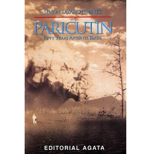
On February 20, 1943, Paricutín Volcano erupted in a farmer’s cornfield in Michoacán. Simón Lázaro Jiménez, now a carpenter by trade, was just a young boy. Here, for the first time, an indigenous P’urepecha Indian relives, in vivid and entertaining prose, his first-hand experiences on that fateful day and during the months that followed.

This 51-page softcover booklet includes simple maps and 16 previously unpublished photos, including several by acclaimed German photographer Walter Reuter.

Geo-Mexico is reader-supported. Purchases made via links on our site may, at no cost to you, earn us an affiliate commission. Learn more.

Paricutín, 50 years after its birth was written by Simón Lázaro Jiménez, and translated by Tony Burton. The booklet was published by Editorial Agata in 1994.

“Early that morning when we reached the town all the houses were completely deserted, with their doors open but nobody inside. We went round the town three times and found five men reciting the Holy Rosary…” (p 14)

“The first flows of lava oozed out of the volcano’s mouth and formed a hard initial slope but this didn’t work as Nature intended. It only resulted in reinforcing the side, enabling the volcano to increase its height, which is just what happened.” (p 23)

“The greatest number of tourists always arrived at night because this was the best time to appreciate, in all its splendor, in all its magnitude, this marvel of Nature, and the volcano, as if showing off its immense pride, threw its fiery stones as high as possible. These same stones would then totally cover everything…” (p 27)

The author tells a compelling tale, and one which might never have seen the light of day had it not been for the generosity of Editorial Agata in arranging its translation and publication.

Organic farming helps the Mam of Chiapas regain their cultural identity

 Books and resources  Comments Off on Organic farming helps the Mam of Chiapas regain their cultural identity
Apr 192010
 

The Mexican Mam (there are also Guatemalan Mam) first settled in Chiapas in the late nineteenth century, mainly in the deforested mountains of the eastern part of the state. They had virtually disappeared from view as a cultural group by 1970, having lost most of their traditional customs. Today, the 8,000 or so Mam, living close to the Guatemala border, have shown that it is possible for some indigenous groups to re-invent themselves, to secure a stronger foothold in the modern world.

Mexican policies from 1935-1950 towards Indian groups were focused on achieving acculturation, so that the groups would gradually assume a mestizo identity. It was widely held at the time that otherwise such isolated groups would inevitably be condemned to perpetual extreme poverty. To the Mam, this period is known as the “burning of the clothes”. Almost all of them lost their language, traditional dress, and methods of subsistence, and even their religion, in the process. Indeed, for a time, the term Mam never appeared in any government documents.

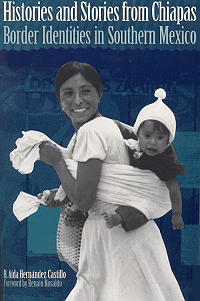
Cover of Histories and Stories bookFrom 1950-1970, the Mexican government opted for a modernization approach, building roads (including the Pan-American highway) and attempting to upgrade agricultural techniques. The mainstay of the regional economy is coffee. During this period, most Mam were peasant farmers, subsisting on corn and potatoes, gaining a meager income by working, at least seasonally, on coffee plantations. Working conditions were deplorable, likened in one report to “concentration camps”. Plantation owners forced many into indebtedness. The Mam refer to this period as the time of the “purple disease”: onchocercosis, spread by the so-called coffee mosquito. Untreated, it leads to depigmentation, turning the skin purple, skin lesions and blindness. Reaching epidemic proportions, it devastated the Mam peasants who had no access to adequate medical services.

After 1970, the Mam gradually re-found themselves, as official policy was to foment a multicultural nation. Some, especially many who had become Jehovah’s Witnesses, migrated northwards forming several small colonies, promoted by the government, in the Lacandon tropical rainforest on the border with Guatemala. Others, spurred on by Catholic clergy influenced by liberation theology, began agro-ecological initiatives.

For instance, one 1900-member cooperative, ISMAM (Indigenous People of the Motozintla Sierra Madre), specialized in the production of organic coffee. ISMAM’s agro-ecological initiatives benefited from the advice of the community’s elders and rescued many former sound agricultural practices, such as planting corn and beans alongside the coffee bushes to avoid the degradation that can result from monoculture. It halted the application of agrochemicals, and studied methods of organic agriculture and land restoration. Its coffee, adroitly marketed, commands premium prices, double those of regular coffee sold on the New York market. The Mam have effectively taken advantage of modern technology, from phones to e-mail, to overcome their isolation, and compete on their own terms, developing export markets in many European nations, as well as the U.S. and Japan.

At the same time, the Mam have re-invented their cultural identity and helped revive the language and traditional forms of dance. They have also rewritten their past. The revisionist version is that they always had the utmost respect for nature and had always lived in harmony with the environment. In reality, as historical geographers have demonstrated, this was not always the case. Whatever the historical reality, the defense of the earth, nature and their culture is now central to the Mam.

The main source for this post is R. Aída Hernández Castillo’s Histories and Stories from Chiapas. Border Identities in Southern Mexico (University of Texas Press, 2001).

Link to original article on MexConnect
The first geography field trip guide in Mexico

 Books and resources, Teaching ideas  Comments Off on The first geography field trip guide in Mexico
Apr 032010
 

Despite the popularity of geography in Mexico’s high schools, students are rarely involved in any geographic fieldwork until they reach university. The major exceptions are those students lucky enough to attend one of the international schools offering courses such as the International Baccalaureate (IB) Diploma Programme. The IB geography syllabus requires all students to have undertaken and written up a report on fieldwork. Most IB fieldwork is hypothesis-based.

It is perhaps not surprising therefore that the number of publications relating to fieldwork in Mexico is very small. There have been a limited number of specialist “field guides” published, relating to geology and geography, and coinciding with international conferences.

To the best of my knowledge, the first fieldwork guide aimed at high school students, teachers and the general public was written following a meeting of teachers in Mexico City in March 1979. Excursiones was designed to be a guide for “teachers, parents and/or organized groups interested in finding pleasant and educational ways of enjoying our environment and encouraging the spiritual elements inherent in making use of the tourist attractions that form part of Mexico’s heritage.”

The book, published by Editorial Limusa in 1983, has 14 general chapters (clothing, food, first aid, etc), followed by 17 destination specific chapters:

  • Cacahuamilpa
  • Taxco
  • Zempoala
  • Tepoztlán
  • Desierto de los Leones
  • Ruta de la Estrella
  • Valle de Bravo
  • Isla de los Aves-Ocotal
  • El Xinantécatl and its lakes
  • Piedras Encimadas
  • Ruta de los Volcanes
  • Africam Safari
  • El Chico
  • Basalt columns
  • Tolantongo
  • El Xitle and El Ajusco
  • Chapingo-Texcoco

We’ll take a closer look at the opportunities offered for fieldwork in some of these locations in future posts.

Mexico’s population in 1990, 2010 and 2050

 Books and resources, Teaching ideas, Updates to Geo-Mexico  Comments Off on Mexico’s population in 1990, 2010 and 2050
Feb 082010
 

Want your very own Geo-Mexico bookmark?

This link – Population of Mexico in 1990, 2010 and 2050 – is to a pdf file of three age-sex pyramids showing the population of Mexico in the years 1990 and 2010, and the predicted population for the year 2050.

Print the file to make your own Geo-Mexico bookmark and get a fascinating insight into Mexico’s likely future population. Mexico’s population growth rate has fallen dramatically since 1990. More surprisingly, between now and 2050, the average age of people in Mexico will rise rapidly. Mexico is set to move from a predominately young population to a predominately old population in only a couple of generations.

What else can you say about Mexico’s population from a close analysis of the population pyramids? (Feel free to post your comments below)

History of geography in Mexico

 Books and resources  Comments Off on History of geography in Mexico
Dec 292009
 

Probably the earliest (and to date one of the very few) books about the history of geography in Mexico :

Title: Apuntes para la historia de la geografía en México.
Author: Orozco y Berra, Manuel (1816-1881)
Publisher: Imprenta de Francisco Diaz de Leon, Mexico City.
Date of publication: 1881.