Mexico has seven of the world’s 100 best hotels

 Mexico's geography in the Press  Comments Off on Mexico has seven of the world’s 100 best hotels
Jan 262015
 

A survey of more than 75,000 Condé Nast Traveler readers placed seven Mexican hotels in the world’s top 100.

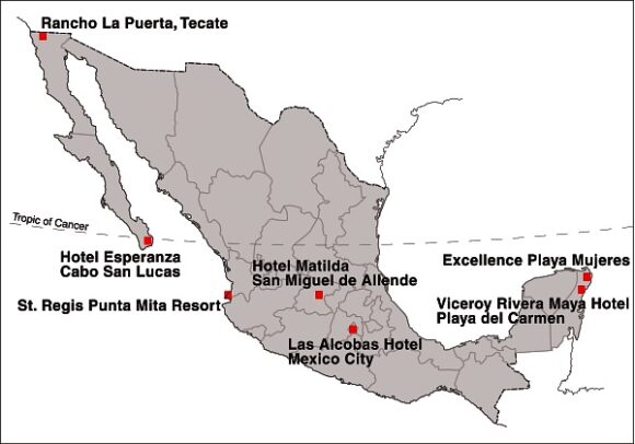
Location of Mexico's Top Seven Hotels

Location of Mexico’s Top Seven Hotels

Mexico’s top hotel (#15 in the rankings) was the Viceroy Rivera Maya hotel, in Playa del Carmen (Quintana Roo). It was joined in the top 100 by Rancho La Puerta in Tecate (Baja California), St. Regis Punta Mita Resort (Nayarit), Las Alcobas hotel (Mexico City), Hotel Matilda in San Miguel de Allende (Guanajuato), Hotel Esperanza in Cabo San Lucas (Baja California Sur) and the Excellence Playa Mujeres (Quintana Roo).

In related news, Grupo Posadas is investing one billion dollars over the next three years to open 49 new hotels, many of them in the firm’s Fiesta Americana chain. Meanwhile, at the opposite end of the hotel spectrum, Motel 6, the “McDonald’s of the hotel industry”, which has 1,200 locations in the USA and Canada, is opening 30 hotels in Mexico within the next three years.

The operator of the Motel 6 chain, G6 Hospitality, will introduce both its brands: Motel 6 and Estudio 6 (designed for extended stays) during its first foray into Latin America. The first of the new hotels will open in Salamanca (Guanajuato) in late-2015, with additional locations to follow, including Mexico City, Monterrey and several resort destinations.

Related posts:

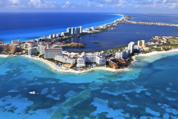
Tourist numbers for Cancún, 2000-2014

 Updates to Geo-Mexico  Comments Off on Tourist numbers for Cancún, 2000-2014
Jan 212015
 

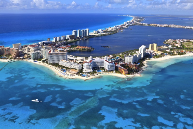
The table shows the number of tourists (national and international) visiting Cancún, Quintana Roo, Mexico, 2000-2013.

Cancún by Arthur Gonoretzky (Flickr)

Cancún by Arthur Gonoretzky (Flickr)

From 2000 until 2011, tourist numbers fluctuated between 2.8 and 3.3 million. Since 2011, tourist numbers have risen sharply, to 3.6 million in 2012, 4.1 million in 2013 and a preliminary estimate of 4.3 million for 2014.

YearNumber of touristsYearNumber of tourists
20003 043 00020083 265 591
20012 986 00020092 878 811
20022 826 00020103 015 690
2003n/a20113 115 177
2004n/a20123 642 449
20053 072 00020134 093 942
2006n/a20144 300 000 (estimate)
20073 004 8022015?

Cancún currently has more than 3000 condominium units and more than 35,000 hotel rooms. According to the first draft of the Programa de Desarrollo Urbano del Centro de Población Cancún 2014-2030, the city could have as many as 46,000 hotel rooms by 2030.

This projection is well below the earlier estimate, made in 2013, of 64,000 rooms by 2030, but the new figure is claimed to be more in line with planned improvements to local water supply. The development of Cancún has often been criticized for paying insufficient attention to considerations of urban density, water supply and environmental impacts.

 Related posts:

Jan 132015
 

At this time of year, Mexico attracts millions of visitors seeking to escape the cold weather further north. The vast majority of visitors will never experience any problem during their travels in Mexico, but both the US State Department and Canadian government continue to issue regular warnings to those considering travel in Mexico. Some of these warnings are specific to certain stretches of highway; others are broader and focus on cities or regions. Click below for the current US travel warnings related to Mexico.

  • Current US Travel Advisory for Mexico

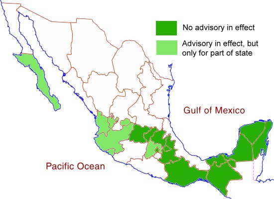
The states left white on the map below all have advisories in effect (as of mid-January 2015) for most or all of the state in question. For the states shaded light green, only small parts of the state have advisories in place, while no advisories are currently in place for those states shaded dark green.

US Travel Advisory Areas, December 2014

US Travel Advisory Areas, December 2014: All states, other than those colored dark green, have travel advisories in place for at least part of the state

The Canadian government offers its own travel warnings for Mexico:

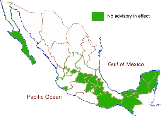
The Canadian advisories apply to all those states left white on the map below. States shaded dark green have no travel advisory in effect so far as the Canadian government is concerned.

Canadian Travel Advisory, November 2014. No advisory in effect for states colored dark green.

Canadian Travel Advisory, November 2014. No advisory in effect for states colored dark green.

The most obvious difference between the maps is that the US State Department is relatively unconcerned about the states of Jalisco and Nayarit, while the Canadian authorities have included them in a regional advisory.

States shaded dark green on both maps are areas where the US State Department and the Canadian government have no serious concerns about travel safety. These states, where travel is considered safe, include Guanajuato (including the cities of Guanajuato and San Miguel de Allende), Querétaro (including Querétaro City), Hidalgo, Puebla (including Puebla City), Oaxaca (Oaxaca City, Puerto Escondido and Huatulco), Chiapas (Tuxtla Gutiérrez and San Cristóbal de las Casas), Tabasco, Campeche, Yucatán (Mérida) and Quintana Roo (Cancún, Riviera Maya).

As always, tourists visiting Mexico and traveling within Mexico are advised to be cautious about visiting rural areas (especially in states where travel warnings are in place), to check local sources such as web forums for updates on the latest conditions, and to avoid driving at night.

Safe travels! Enjoy your trip!

Related post

Seasonal greetings from Geo-Mexico!

 Other  Comments Off on Seasonal greetings from Geo-Mexico!
Dec 242014
 

Geo-Mexico wishes all its readers the warmest seasonal greetings.

tenango-de-flores-xmas-tree2

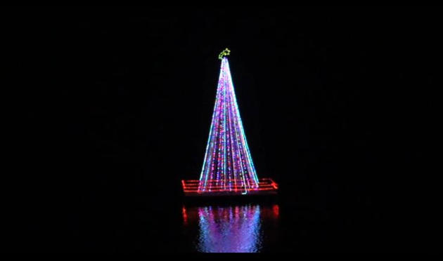
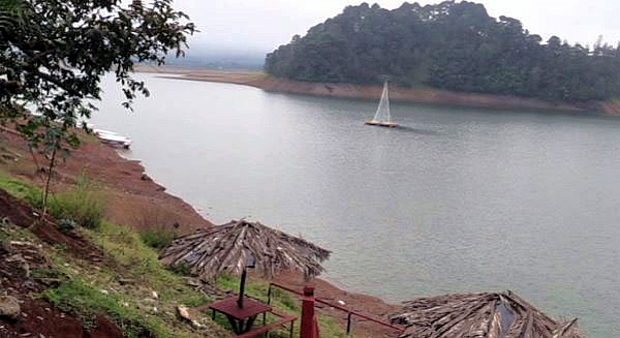
The photo shows Mexico’s only floating Christmas Tree. It can be seen near Tenago de las Flores in the municipality of Huachinango in the northern part of the state of Puebla. The 15-meter-high tree, with Christmas lights, stands on a wooden platform atop a raft of 32 metal drums in the middle of the Tenango reservoir, upstream from the Necaxa Dam, Mexico’s first hydroelectric project, dating back to 1905. The tradition started only three years ago when local residents decided that a floating Christmas tree might prove to be a tourist attraction.

The 10-min video below shows the “light up” of the tree early this month, complete with music and singing.

Tenango de las Flores has been more famous in the past for its large-scale production of flowers (floriculture) and for its annual Flower Festival, as well as for featuring in an award-winning 1957 film called Tizoc: Amor Indio, starring María Félix and Pedro Infante. The film won the Golden Globe Award for Best Foreign Language Film at the 15th Golden Globe Awards (1958).

tenango-de-flores-xmas-tree-day

Related posts:

Dec 062014
 

In the second half of the 19th century, the Mexican government undertook am ambitious railway building program that eventually connected Mexico City with the USA, as well as with ports on the Atlantic Ocean and Pacific Ocean

Since the privatization of the railway system in 1995, many lines have fallen out of use and passenger services have been all but abandoned, leaving hundreds of kilometers of disused track and isolating some rural communities from the nearest large city. Much of Mexico’s historic railway infrastructure now lies in ruins.

In the past decade, some former railway lines have been turned into walking and cycling trails. For example:

The state of Jalisco has started to recondition 120 kilometers of former railway routes as Green Route (Via Verde) trails for non-motorized traffic (hikers, cyclists, horse riders). Many of the old stations along these routes will be restored to provide essential services and exhibition space. The former train station in Ameca (on the extreme northern edge of the town) has been renovated to serve as the start of one of these routes, with exhibits focusing on the history of the railroad, local fiestas and the region’s haciendas. The lovely building, dating back more than a century, witnessed its last train in 1995.

Given that the railways played such a key role in the Revolution, enabling both sides to move troops quickly around the country, it is fitting that they are now the basis for this new revolution involving cultural tourism. (Western Mexico, A Traveler’s Treasury, p 61).

Others lines, elsewhere in Mexico, have been explored by two intrepid Mexican artists as part of an unusual geo-art project. Artists Ivan Puig and Andres Padilla Domene built a vehicle capable of traveling on train tracks and explored some of the country’s abandoned railway lines. As they went, they photographed hundreds of ruins and recorded hours of interviews with people they met. They later did something similar in Ecuador, but that’s another story.

Their striking silver road-rail vehicle is known as SEFT-1, where SEFT stands for Sonda de Exploración Ferroviaria Tripulada (Manned Railway Exploration Probe).

seft-1

The artists recorded their experiences in videos, photographs and collected objects. Interviewing people they met, often from communities isolated by Mexico’s passenger railway closures, they shared their findings online, where audiences could track the probe’s trajectory, view maps and images and listen to interviews.

Their first London (UK) exhibition, SEFT-1 Abandoned Railways Exploration Probe – Modern Ruins 1:220, was commissioned by The Arts Catalyst and presented at the Furtherfield gallery space in the heart of Finsbury Park. In the exhibit, the artists explore how the ideology of progress is imprinted onto historic landscapes and they also reflect on the two poles of the social experience of technology: use and obsolescence.

For this exhibition, the artists also invited British expert model railway constructors to create scale reproductions of specific Mexican railway ruins exactly as they had found them. One gallery became a space for the process of model ruin construction. The room’s walls displayed the pictures, documents, plans and other materials used as reference for the meticulously-elaborated models.

The Artists

Ivan Puig (born 1977, Guadalajara) has exhibited internationally in Mexico, Germany, Canada, Brazil and the USA. Puig, a member of the collective TRiodO (with Marcela Armas and Gilberto Esparza), lives and works in Mexico City.

Andrés Padilla Domene (born 1986, Guadalajara) has exhibited work in Mexico, the USA and Ecuador. His video work as director and producer with Camper Media includes documentaries, fiction films and TV shows.

Related posts:

Nov 232014
 

Many of the arts and crafts found in Michoacán date back to pre-Columbian times, but now incorporate techniques and materials that were brought from Europe and elsewhere. Many of the introductions occurred during the time of Vasco de Quiroga (ca 1470-1565), after whom the town of Quiroga, at the eastern extremity of Lake Pátzcuaro, is named.

Visitors to Michoacán area often amazed to discover that towns even only a few kilometers apart have developed completely different handicrafts, and that all the handicraft workshops in any one town seem to focus on making precisely the same items. If one workshop in a town specializes in wooden items, all the neighboring workshops appear to do the same. Just how did these very distinctive spatial patterns come about?

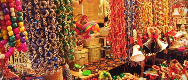
Craft market in Tzintzuntzan, Michoacan

Craft market in Tzintzuntzan, Michoacan

The answer to the oft-asked question, “Why does each town in Michoacán have its own handicrafts?”lies in the history of this area and, in particular, of the efforts almost five hundred years ago of one Spanish priest.

Who was Vasco de Quiroga?

Vasco de Quiroga trained originally as a lawyer. He later took holy orders and arrived in the New World in 1531, already in his sixties. He gained rapid promotion and six years later was appointed Bishop of Michoacán, with the express purpose of trying to clear up the mess left by Nuño Beltrán de Guzmán’s rampage through western Mexico, and to placate the bad feelings of the indigenous Purépecha populace.

Vasco de Quiroga based his approach on the Utopian principles espoused by Thomas More. He established a series of communities in the vicinity of Lake Pátzcuaro, the heart of Purépecha country, improved security, and set up hospitals and schools serving the local people.

Agricultural improvements

Recognizing the importance of agriculture, Vasco de Quiroga introduced European implements and methods as well as new crops, including wheat and other cereals, fruits and vegetables. Perhaps his most noteworthy introduction was the banana. The first bananas to be grown anywhere in Mexico were brought by Vasco de Quiroga from Santo Domingo in the Caribbean and planted in Tzintzuntzan.

Handicrafts

Alongside religious instruction, Vasco de Quiroga organized training in arts and crafts. His efforts quickly won over many of the local people who came to acknowledge that the hostility they had experienced from their first contacts with Europeans was not typical of all the newcomers. The kindly Bishop came to be sufficiently respected by them to be awarded the honorific title of “Tata” (“Father”) Vasco.

The local indigenous Indians had already developed the skills needed for varied ceramics, wood and leather products, copper items, and woven cotton and agave fiber textiles. They also used the local lake bulrushes (tule). Vasco de Quiroga introduced new techniques which allowed the artisans to multiply their production.

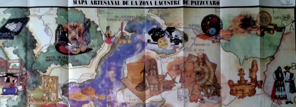
To encourage specialization, and limit direct competition between villages, “Tata” Vasco allocated specific crafts to specific places, a pattern that continues to the present. The particular handicraft developed in each village also reflects the availability of local raw materials such as bulrushes needed for mats, or clay for pottery. On account of the fine quality of local clays, the making of ceramics was encouraged in the villages of Tzintzuntzan, Patamban, Santa Fe de la Laguna, Capula and Pinícuaro. Ironworking and locksmithing were introduced in San Felipe de los Hereros; quilting and embroidery in San Juan de las Colcahas, and so on.

Section of tourist map showing some of handicraft towns near Lake Patzcuaro

Section of tourist map showing some of handicraft towns near Lake Patzcuaro

The arts and crafts skills in the villages around Lake Pátzcuaro and elsewhere in Michoacán have been passed down to this day, becoming more finely honed with each successive generation, producing craftsmen who are among the finest in the country. They are responsible for a truly amazing variety of handicrafts, fine art and furniture items.

Among the better known places to seek out particular handicrafts are:

  • Angangueo: woolen items
  • Cuanajo: wooden chests and furniture
  • Erongarícuaro: wooden furniture, earthenware
  • Ihuatzio: petate mats
  • Jarácuaro: palm hats (woven)
  • Paracho: guitars and stringed instruments
  • Pátzcuaro: wool, lacquer work, silver jewelry, toys, etc
  • Quiroga: painted trays and bowls, leather goods, wooden toys
  • Santa Fe de la Laguna: pottery
  • Santa Clara del Cobre: copper items (housewares, miniatures)
  • Tzintzuntzan: wood, pottery, straw decorations and toys
  • Uruapan: lacquer work
  • Zirahuén: wood and cloth dolls

Given this partial listing, is it any wonder that Michoacán is one of the best states in Mexico for finding interesting handicrafts? Happy shopping!

Eat here to believe it! The second phase of Mexico’s “Live It To Believe It!” tourism campaign

 Other  Comments Off on Eat here to believe it! The second phase of Mexico’s “Live It To Believe It!” tourism campaign
Nov 212014
 

Mexico’s tourism officials have unveiled the second phase of their “Live It To Believe It!” campaign. The first phase focused on some relatively unusual destinations and sights in Mexico. The second phase is based on the nation’s extraordinarily varied gastronomy. “Eat Here to Believe It!” is our suggested shorthand.

Mexican cuisine has taken the world by storm in recent years and Mexico is rapidly becoming one of the best destinations in Latin America for food-related travel. Promotional videos (sadly, no longer available on Youtube) highlight how regional variations in cuisine across Mexico mean that a vacation in Mexico can be like visiting several different countries in a single trip.

In addition to items such as tequila and mescal enjoying international protection and recognition via their denomination-of-origin status, in 2010 UNESCO added the indigenous regional cuisine of Michoacán to its “Intangible Cultural Heritage of Humanity” list.

Quoting from the UNESCO site:

Traditional Mexican cuisine is a comprehensive cultural model comprising farming, ritual practices, age-old skills, culinary techniques and ancestral community customs and manners. It is made possible by collective participation in the entire traditional food chain: from planting and harvesting to cooking and eating. The basis of the system is founded on corn, beans and chili; unique farming methods such as milpas (rotating swidden fields of corn and other crops) and chinampas (man-made farming islets in lake areas); cooking processes such as nixtamalization (lime-hulling maize, which increases its nutritional value); and singular utensils including grinding stones and stone mortars.

Native ingredients such as varieties of tomatoes, squashes, avocados, cocoa and vanilla augment the basic staples. Mexican cuisine is elaborate and symbol-laden, with everyday tortillas and tamales, both made of corn, forming an integral part of Day of the Dead offerings.

Collectives of female cooks and other practitioners devoted to raising crops and traditional cuisine are found in the State of Michoacán and across Mexico. Their knowledge and techniques express community identity, reinforce social bonds, and build stronger local, regional and national identities. Those efforts in Michoacán also underline the importance of traditional cuisine as a means of sustainable development.

For more about Mexican cuisine, visit the amazing award-winning blog Mexico Cooks! and also browse the huge selection of recipes, articles and tips about all aspects of Mexican food and cooking in the “Cuisine” section of MexConnect.

¡Buen provecho!

Related posts:

Nov 132014
 

Mexico’s varied geography has made it a premier destination for all kinds of adventure tourism, from caving and canyoneering to jungle treks, white-water rafting and rock climbing.

This 6-minute video shows mountaineer Alex Honnold climbing the 460-meter (1500-feet) high rock face known as El Sendero Luminoso near Monterrey in northern Mexico. What makes this climb special (and slightly scary to watch) is that Honnold climbs solo and without any safety measures such as ropes.

Interviewed for National Geographic Adventure before he had seen the video, Honnold said, “I’m not sure what the video shows, but my true solo was all alone with no photogs [photographers] or helis [helicopters]. We then went back and filmed on big portions of it. In my mind there’s a clear difference between personal climbing—the actual solo—and work days—the filming afterward.”

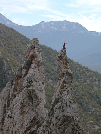
"The Spires" in El Potrero Chico climbing area (Wikipedia photo)

“The Spires” in El Potrero Chico climbing area (Wikipedia photo)

The El Sendero Luminoso rockface is in an area known as El Potrero Chico, a short distance from Monterrey, near the town of Hidalgo.

The Wikipedia entry for El Potrero Chico describes it as having “a large range of different climbs, most of them in the 5.8 to 5.13 grade. The type of climbing can range from steep overhanging face to easy slab. The rock is usually quite sharp. The climbs are mostly situated in a canyon at the entrance of the park, while the interior offers undeveloped mountain terrain with many mountain biking routes, ranging from very easy to expert options.”

According to Wikipedia, El Potrero is “considered one of the top 10 locations to sport climb in the world. In addition to well over 500 routes, the area boasts the second longest sport route in North America, Timewave Zero, with 23 pitches and over 2,000 feet (610 m).”

Related posts:

Mexcaltitán, a magical island town in Nayarit

 Other  Comments Off on Mexcaltitán, a magical island town in Nayarit
Nov 102014
 

A short distance north of San Blas, in Nayarit, is a small island called Mexcaltitán. With barely four thousand inhabitants, it would scarcely be expected to have any real link to Mexico City, the world’s greatest metropolis of some twenty million people. But it does, and the link is to be found in the amazing story of the founding in 1325 of the Aztec capital Tenochtitlan, the city which was later conquered and sacked by the Spanish and rebuilt as Mexico City.
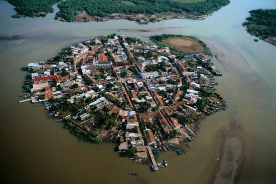
The island and village of Mexcaltián, Nayarit

The island and village of Mexcaltián, Nayarit

Historians have long wondered about the origins of the Mexica people, or Aztecs as they later became known. There is virtually no evidence of them before they founded the highly organized city of Tenochtitlan in 1325. Clearly such a civilization cannot just have sprung up overnight. So, where did they come from? Mexica (Aztec) legend tells of a long pilgrimage, lasting hundreds of years, from Aztlán, the cradle of their civilization, a pilgrimage during which they looked for a sign to tell them where to found their new capital and ceremonial center. The sign they were looking for was an eagle, perched on a cactus. Today, this unlikely combination, with the eagle now devouring a serpent, is a national symbol and appears on the national flag.
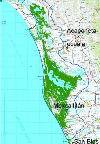
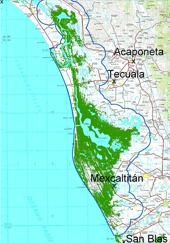
Map showing location of Marismas Nacionales

Map showing location of Marismas Nacionales

In recent years more and more evidence suggests that Aztlán may be far from mythical and that Mexcaltitán, the island in Nayarit, could be its original site. Ancient codices (pre-Columbian hand-painted manuscripts) prove that the Aztecs’ search for a new place to live was ordained by Huitzilopochtli, their chief god. It began in about AD1111 when they departed from an island in the middle of a lake. Their two hundred year journey took them through present-day Nayarit, Durango, Zacatecas, Jalisco, Michoacán, Guanajuato and Querétaro, and they may well have rested awhile on encountering familiar-looking islands in the middle of lakes such as Chapala and Pátzcuaro.

One of Huitzilopochtli’s alternative names was Mexitli and the current spelling of Mexcaltitán could be interpreted as “Home of Mexitli”, or thus, “Home of Huitzilopochtli”. In fairness, it should be pointed out that if the original spelling was Metzcaltitán (and “tz” often became transliterated to “x” down the centuries), then the meaning would become “Place next to the home of the Moon”.

Whatever the etymology of the name, early codices such as the Boturini Codex show the early Aztecs setting out from an Aztlán surrounded by water, in small canoes. The Mendoza Codex, depicting life in Tenochtitlan, has illustrations of similar canoes and, in both codices, the canoes and method of propulsion by punting show remarkable similarity to the present-day canoes of Mexcaltitán. Visitors to the island still have to undertake a canoe or panga ride to reach the village and it is an intriguing thought that the Mexica/Aztecs were doing exactly the same over eight hundred and fifty years ago.

Further evidence comes from an old map of New Spain. Drawn by Ortelius in 1579, it shows Aztlán to be exactly where Mexcaltitán is to be found today, though perhaps at the time this was largely conjecture.

The street plan of Mexcaltitán, best appreciated from the air, is equally fascinating. Two parallel streets cross the oval-shaped island from north to south, and two from east to west, with the modern plaza in the middle, where they intersect. The only other street runs around the island in a circle, parallel to and not far from the water’s edge. This street may have been the coastline of the island years ago and may even have been fortified against the invading waters of the rising lake each rainy season. Today, as then, for several months in summer the streets become canals, bounded by the high sidewalks each side and Mexcaltitán becomes Mexico’s mini-Venice as all travel has to be by canoe.

This street pattern has cosmic significance. It divides the village into four quarters or sectors each representing a cardinal point, reflecting the Mexica conception of the world. The center can be identified with the Sun, the giver of all life. The Spanish, as was their custom, built their church there, and today the central plaza with its bandstand is the obvious focal point of the community. Small shops, a billiards hall, a modern, well-laid out museum, and an administrative office complete the central area of the village.
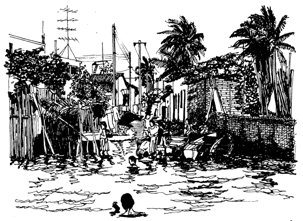
 

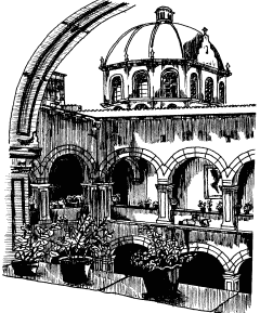
Mexcaltitán pen and ink drawing by Michael Eager

Mexcaltitán (pen and ink drawing by Michael Eager from chapter 26 of Western Mexico, A Traveler’s Treasury). All rights reserved.

Low houses, of adobe, brick and cement, line the dirt streets and extend right down to the water’s edge, in some cases even over the water’s edge into the surrounding lake, on stilts. Land on the island is at a premium and, with an ever-growing population, saturation point is very near.

A century ago, the locals turned on some foreigners who came to hunt female egrets, valued for their plumes back in the days when feathers adorned fashionable ladies’ hats. Today, provided only photos are taken, all visitors are welcomed! The villagers celebrate one of the most unusual and distinctive fiestas in all of Latin America. On 29 June each year they organize a regatta which consists of a single race between just two canoes, though naturally hundreds of other pangas are filled with spectators. One of the competing canoes carries the statue of Saint Peter from the local church, the other carries Saint Paul.

Elaborate preparations precede the race. The village streets are festooned with paper streamers and the two canoes are lavishly decorated by rival families carrying on an age-old tradition. The Ortíz family is responsible for St. Peter’s canoe, the Galindo family for St. Paul’s. The statues of the two saints are taken from the church and carried in procession to the boats. A pair of punters has previously been chosen from among the young men of the village for each boat. The punters have been suitably fortified for the contest with local delicacies such as steamed fish, shrimp empanadas, and the local specialty, tlaxtihuile, a kind of shrimp broth. Each boat, in addition to the punters and the statue of the saint, carries a priest to ensure fair play. The race starts from the middle of the eight kilometer long lake after a short religious service in which the priests bless the lake and pray for abundant shrimp and fish during the coming year. Then surrounding spectator canoes, some with musical bands, and others shooting off fireworks, move aside and the race begins.

Nowadays, St. Peter and St. Paul take it in turns to win, most considerate in view of the violence which years ago marred the post-race celebrations when the race was fought competitively. The ceremonial regatta safely over, land based festivities continue well into the night.

A canoe ride around the island takes about 30 minutes and provides numerous photo opportunities as well as many surprises including a close-up view of the island’s only soccer pitch—in the middle of the lake, under half a meter of water. The local children are, perhaps not surprisingly, expert “water soccer” players, a fun sport to watch.

Even if you’re not interested in the island’s past and are unable to see it on fiesta day, your trip to Mexcaltitán will be memorable. This extraordinary island and its village have to be seen to be believed.

The island is reached from the Tepic-Mazatlán highway, Highway 15. There are two alternatives. The northern route is signposted 73 kilometers north of Tepic; it starts with 26 kilometers of paved road crossing swampy paddy fields, followed by 16 kilometers of well-graded dirt road to Ticha, the landing-stage for boats to the island. The drive is through a naturalist’s paradise, teeming with wildlife. The equally scenic southern route begins 57 kilometers from Tepic and is via Santiago Ixcuintla (basic hotels only; don’t miss visiting the center for Huichol Indian culture and crafts) and Sentispac. It leads to the La Batanga landing-stage, and is fully paved.

Note:

This post is based on chapter 26 of my “Western Mexico: A Traveler’s Treasury” (link is to Amazon’s “Look Inside” feature), also available as a Kindle edition or Kobo ebook.

Related posts:
The 2014 Tecate SCORE Baja 1000 off-road race

 Other  Comments Off on The 2014 Tecate SCORE Baja 1000 off-road race
Nov 082014
 

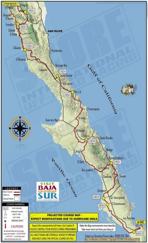
Entrants in the 2014 Tecate SCORE Baja 1000 off-road race have to complete a grueling off-road route that runs almost the entire length of the Baja California Peninsula. The race starts in Ensenada, Baja California, and ends in La Paz, Baja California Sur (see map). The approximate point-to-point distance is 1820 kilometers (1,130 miles). The 47th Tecate SCORE Baja 1000 race is being held this year from 12-16 November.

Route of Score 1000 Baja off-road race

Route of Score 1000 Baja off-road race

The race gives us a good excuse to offer this brief introduction to the geography of the very long, narrow Baja California Peninsula, which stretches for about 1150 km (700 mi).

In the north, it is composed of mostly granite, while the south is mostly marine sediments and lava.

To the east of the peninsula, the Sea of Cortés (Gulf of California) occupies a trough resulting from a series of faults which are linked to the famous San Andreas Fault system in California. Prior to the opening up of the Gulf of California, the peninsula was attached to the mainland. There are several volcanic islands in the Gulf.

The backbone of the peninsula is a crystalline mountain system with many peaks exceeding 1500 m (5000 ft) and some reaching as high as 3000 m (10,000 ft). The mountains have longer, gentler western slopes and steeper more rugged eastern slopes. Thus, as viewed from the Gulf of California, the Baja Mountains and the Western Sierra Madre look steep, foreboding and very rugged, while from the other side they look more subdued.

Climatically, almost the entire peninsula is extremely arid and forms the western part of the Sonoran Desert. It receives only limited and infrequent rainfall. However, the southern part of the peninsula does experience the occasional hurricane (such as Hurricane Odile earlier this year) which brings powerful winds and torrential downpours.

Population is distributed very unevenly on the Baja California Peninsula. The heaviest concentration of people is found in the extreme north, close to the U.S. border, a region which includes the cities of Tijuana, Mexicali and Ensenada. There are very low densities of population in most of the middle section of the peninsula, where the most important settlements include Guerrero Negro, Santa Rosalía,Ciudad Insurgentes and Ciudad Constitución.

The southern portion of the peninsula has attracted more settlement and this area, which includes San José del Cabo, Cabo San Lucas, La Paz and Todos Santos, is one of Mexico’s premier tourism regions.

Want to read more?

Oct 112014
 

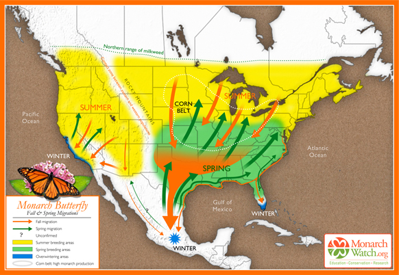
Most monarch butterflies never migrate, but one generation of the North American monarch population undertakes an annual, long distance migration, a journey without parallel in the insect world. Every winter, some one hundred million monarch butterflies fly south into Mexico from the U.S. and Canada. They congregate and spend the winter in a dozen localities high in the temperate pine and fir forests of the states of México and Michoacán.

Where do the Monarchs overwinter?

The exact sites where the butterflies overwinter were only found in the mid 1970s after a search of nearly forty years. Scientists are still unable to explain all the details of this enigmatic annual migration, but their unexpectedly sophisticated navigational ability seems to rely on an incredible innate accuracy in pinpointing their position by using their eyes and antennas to measure the angles of the sun’s rays, compensating for time of day, and ensuring they continue to fly in a southerly direction towards the state boundary separating Michoacán from the State of México.

How fast can they fly?

The tagging of butterflies has proven that they make the 2500 kilometer trip each way at an impressive average speed of 20 km/h, with maximum speeds of up to 40 km/h (25 mph). Monarchs don’t fly at night, partly because they need daylight to navigate and partly because they fly best when sunlight has warmed their wings, like miniature solar panels, raising their body temperatures some 10 to 15 degrees Celsius above ambient air temperatures.

The butterflies are energy-efficient flyers, making regular nectar stops along the way to refuel. One third of their dry body weight is energy-giving fat but far from losing weight on their exhausting journey south, they actually appear to gain it! There are still many mysteries about the monarchs but they certainly provide one of the most amazing natural spectacles to be seen anywhere on earth. Millions of orange butterflies, with black and white-spotted wings, whether flying overhead or, as on cooler days, clinging apparently lifeless to the grey-green fir trees in such numbers that the trees appear to be in blossom, are an absolutely unforgettable sight.

Based on original map design created by Paul Mirocha (paulmirocha.com) for Monarch Watch.

Based on original map design created by Paul Mirocha (paulmirocha.com) for Monarch Watch.

The journey south

In September and October, as temperatures in the U.S. and Canada fall, and food supplies become scarce, the monarchs fly south in small groups. Some of these groups fly only as far as Florida or western California where they spend their winters in milder conditions. But many of the small groups from east of the Continental Divide eventually coalesce and fly much further south, as far as Mexico, arriving en masse in the state of Michoacán towards the end of November.

This migratory group is comprised of as many as 120 million individuals and spends the winter in semi-dormancy, on the pine and oyamel (sacred fir, Abies religiosa) trees found at elevation of about 3050 meters (10,000 feet) along Mexico’s central Volcanic Axis. Until spring comes, in March or April, these butterflies cling to the branches and trunks of the trees, enjoying temperatures between 10 and 16 degrees Celsius, protected from cold northerly winds. Their metabolism slows down in these low temperature, low oxygen conditions and they exhibit movement only on warm, sunny, days.

The generation that flies into Mexico does not mature sexually until the following spring. In February and March, the best months to see them, early spring sunlight begins to penetrate the groves of fir trees, temperatures begin to rise and the forest floor slowly comes alive with new plant growth. The butterflies, having successfully overwintered the worst weather, unfurl their wings and flutter about in search of food and water. As they regain their strength, so they become sexually mature and the mating process starts.

The journey north

After mating, the butterflies begin to leave the reserves, flying back towards the north. Five days later, in northern Mexico and the southern U.S., each female lays two to three hundred eggs on the underside of milkweed leaves. They first check (by smell and touch) that no eggs have already been laid there, and then space their eggs in such a way so as to ensure that each larva that hatches two to three days later will have an adequate supply of food. The larvae grow quickly, changing their skins five times before becoming pupae. After a further two weeks, butterflies emerge, and fly northwards. Each generation of monarchs probably acquires a different chemical “blueprint”, based on the exact species of milkweed it eats, giving it the information it needs to know where to fly. Eventually, by April, the northernmost butterflies reach Canada.

No individual butterfly completes the entire 5000 kilometer round trip. Most of those that fly south die soon after mating in spring (with males often dying in the reserves and never starting their homeward trip), while those who head north cannot hope to survive long into the summer, when normal reproductive cycles, each lasting from four to six weeks, are reestablished.

The last generation of each summer, perhaps prompted by shorter days, soon departs on the next wave of mass migration to Mexico. Those from furthest north will cross the Great Lakes on their return in a single day’s flight, an impressive feat in its own right. They have been spotted flying south at heights up to 1500 meters and exploit thermals to gain height and save energy.

Where to see Monarch Butterflies

Several monarch reserves are open to the public each year. Each has its own distinctive character. Two of the most important reserves are close to the town of Angangueo. Sierra Chincua, north of the town, is the site where the first Canadian-tagged monarch was found in the mid 1970s. This is also where I first saw the butterflies, in 1980, while looking for a potential site for geography fieldwork. It was a serendipitous discovery, and led to me being mistaken for a BBC reporter, but that’s another story!

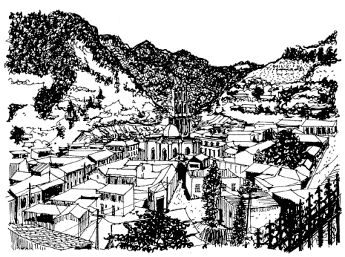
Angangueo. Sketch by Mark Eager; all rights reserved.

Angangueo. Sketch by Mark Eager; all rights reserved.

The most accessible reserve open to the public is El Rosario, south of Angangueo, where there are dozens of souvenir stalls and rustic snack stands—don’t miss sampling the delicious hand-made blue-corn tortillas. The narrow trails in the sanctuary, with information boards at regular intervals, wind steeply several hundred meters uphill, reaching a maximum altitude of 3050 meters. This altitude can cause some shortage of breath and air temperatures are generally low, so be sure to bring a sweater.

El Rosario can be reached from either Angangueo (steeper but more direct approach) or Ocampo. Anyone driving their own vehicle to El Rosario is advised to use the route via San Felipe (on Highway 15) and then Ocampo. From Ocampo any vehicle with adequate ground clearance, including the local taxis, can negotiate the fourteen kilometers to the monarch sanctuary parking lot.

The San Felipe-Ocampo junction on Highway 15 is marked by a line of fruit and soft-drink stalls, many of which in season sell delicious granadas (pomegranates). Also at this junction is an interesting sixteenth century church which, until as recently as 1995, had tombstones in its atrium, unusual in Mexico. Normally, the Spanish buried their dead as far away from the churchyard as possible, presumably to avoid the risk of disease.

Want to read more?

This post is based on chapter 36 of my “Western Mexico: A Traveler’s Treasury” (link is to Amazon’s “Look Inside” feature), also available as either a Kindle edition or Kobo ebook.

Related posts:
Recycled plastic boats for Xochimilco?

 Mexico's geography in the Press  Comments Off on Recycled plastic boats for Xochimilco?
Oct 092014
 

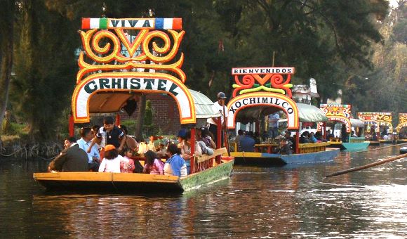
What will they think of next? Officials in Mexico City have plans to provide the tourist zone of the Xochimilco canals with environmentally friendly boats and barges and to gradually substitute the usual wooden ones, which have very high maintenance costs. The plan was unveiled a few weeks ago by Mauricio León, director of infrastructure, modernization and innovation for the Federal District.

Xochimilco (Wikipedia; creative commons)

Xochimilco (Wikipedia; creative commons)

Apparently, the traditional wooden vessels, known as trajineras, with their colorful arches, formerly used mostly to transport goods but now dedicated almost exclusively to tourism, require “an enormous expense” each year since they need to be renovated annually, in part due to “the deterioration in recent years” of the water quality in the canals. According to León, the water contains high levels of fungi that degrade the wood. (Q. In that case, why not clean the water, and keep the traditional designs made of wood?)

Mexico City officials have already launched a prototype of the new, plastic, ecologically-sound craft, and hope that the owners of the traditional gondola-like non-motorized boats will form a cooperative to gradually replace them. The design of the new “technoecological” vessels was created by scientists at the National University (UNAM) and preserves the typical characteristics that have made it a widely recognized symbol of tourism in Mexico.

The great advantage of the new boats, made of recycled PET plastic (some of it no doubt pulled from the canals), polyethylene and volcanic clay is their greater durability and stability. Proponents claim that since they are made of recycled material, unlike the traditional ones for which 20 trees have to be cut down to make each trajiinera, the new boats are much cheaper, require less maintenance and their durability is much greater, with the potential to last up to 120 years.

There is one slight problem: the cost of the machinery required to make them. Authorities hope to persuade the boatmen to form “a cooperative able to get financing for the machines,” which will require an investment of some 5 million pesos ($380,000).

This is a long-term plan, because even when the machines are installed, they can produce only about three or four boats a week, and there are an estimated 1500 trajineras currently plying the canals in Xochimilco.

Related posts:
Mexico hosts 2014 World Tourism Day

 Books and resources, Mexico's geography in the Press  Comments Off on Mexico hosts 2014 World Tourism Day
Sep 272014
 

Today Mexico is hosting World Tourism Day, so this seems like a good time to review the state of Mexico’s tourism sector. The official celebrations are being held in the city of Guadalajara.

The decision by The World Tourism Organization that Mexico should host the 2014 World Tourism Day recognizes Mexico’s importance in world tourism. Mexico is the 13th most popular international destination in the world. In 2013, it welcomed 23.7 million international tourists, who spent 13.8 billion dollars in the country. World Tourism Day 2014 highlights tourism’s social, cultural, political and economic benefits, and its importance in community development.

Earlier this year, Mexico’s Tourism Secretariat published a detailed analysis of the Tourism Industry in Mexico in 2013.

The text of the magazine format publication (link above) is in Spanish, but it includes lots of graphs and maps showing tourism’s trends and patterns. The 21 pages of information cover topics from the origin and spending of tourists to cruise ship ports, hotel occupancy, and number of international flights. The publication offers a wide variety of data and an ideal basis for students who want to design and produce infographics about tourism.

And how is tourism doing in 2014?

So far, all the signs are positive. The number of international visitors for the first half of the year was up 19.6% to 14.2 million, compared to the 11.9 million recorded for the first six months of 2013. Spending in the first half of the year was up 17.6% to 8.435 billion dollars.

Related posts:
Post and Fly Videos of Mexico

 Books and resources  Comments Off on Post and Fly Videos of Mexico
Sep 252014
 

A series of videos made by “Post and Fly Videos” provides an outstanding visual introduction to many of Mexico’s most photogenic sights. Some of the photography is truly stunning.

For a fun introduction, try this 4 minute video (turn your speakers on) which gives a quick tour of many parts of Mexico. (As yet, there are very few Post and Fly Videos of the Yucatan Peninsula, but I’m confident they will remedy this omission before too long!)

A list of the places shown in this 4 minute video is given below (with a few links to relevant Geo-Mexico posts), for those who like to know precisely where particular shots were taken.

Places in the video (in order of appearance):

Marina San José del Cabo, Baja California Sur
El Sidral, San Luis Potosí
Macroplaza Monterrey, Nuevo León
Las Pozas de Xilitla, San Luis Potosí
Tamtoc, San Luis Potosí
Las Estacas, Morelos
Peña del Aire, Hidalgo
El Naranjo, San Luis Potosí
Xochimilco, D.F.
Tamul, San Luis Potosí
Los Cabos, Baja California Sur
Ex Hacienda de Chautla, Puebla
Gran Cenote, Quintana Roo
El Salto, San Luis Potosí
Valle de Bravo, Estado de México
Los Cabos, Baja California Sur
Ex Hacienda de Santa María Regla, Hidalgo
Peña de Bernal, Querétaro
Acopilco, D.F.
Atlixco, Puebla
Kiosco Morisco, D.F.
López Mateos . Baja California Sur
Huasca, Hidalgo
Mantetzulel, San Luis Potosí
Metepec, Estado de México
Todos Santos, Baja California Sur
Tula, Hidalgo
Todos Santos, Baja California
Castillo de la Salud, San Luis Potosí
Holbox, Quintana Roo
Punta Allen, Quintana Roo
Muyil, Quintana Roo
Tepotzotlán, Estado de México
Parque Fundidora, Nuevo León
Santa Fe, D.F.
Balandra, Baja California Sur
Arcos del Sitio, Estado de México
Loreto, Baja California Sur
Tulum, Quintana Roo
Loreto, Baja California Sur
Tulum, Quintana Roo
Xochimilco, D.F.
Todos Santos, Baja California
Aktun Chen, Quintana Roo
Prismas Basálticos, Hidalgo
Marina San José del Cabo, Baja California Sur
Peña del Aire, Hidalgo
López Mateos . Baja California Sur

To see more Post and Fly Videos, explore their website, especially their “Explorando México” section.

How can tourism perception be assessed? A case study using the Lerma-Chapala drainage basin

 Books and resources, Teaching ideas  Comments Off on How can tourism perception be assessed? A case study using the Lerma-Chapala drainage basin
Aug 282014
 

In numerous previous posts, we have looked at the importance of tourism in Mexico, and have examined its impacts at different scales, from the national/international scale at one extreme to the single resort scale at the other:

National scale:

Sub-national regional scale:

Single resort scale

We have also considered the way in which the characteristics of tourism in a resort change over time:

Attempting to quantify the importance or impacts of tourism, beneficial or otherwise, is fraught with methodological difficulties. The number of hotel rooms in different cities is often used as a proxy measure of the relative importance of tourism in different communities, but looking only at tourist capacity “masks  the fact that hotels are rarely full. In 2007, the national occupancy rate was 54.8%. Traditional beach resorts such as Acapulco, Mazatlán and Puerto Vallarta had an occupancy rate of 52.2%, compared to 68.1% for modern, planned mega-resorts like Cancún and Los Cabos. The occupancy rate in the large cities—Guadalajara, Mexico City and Monterrey—was 55.0%, well ahead of the 47.2% for other interior cities.” (Geo-Mexico, p 134).

As in other branches of geography, it is not only the “reality” that matters, but also people’s perceptions of reality. Most decisions concerning location (such as where to live, the best place to start a new business. etc) are taken on imperfect or incomplete information; in other words, these decisions are based, at least to some extent, on perceptions.

In the case of tourism, it is the perception of visitors that matters. This is precisely why certain resorts gain a reputation as being “jet set” or the “in place” to vacation. The “in place” today is not going to be the “in place” in a few year’s time, since perceptions (and reality) change. Nowhere has this proved to be more true in Mexico than in the case of Acapulco.

But is it possible to measure tourist perceptions? It is very difficult to do so directly, but there are ways of tackling this question, and here we look at one approach, based on an analysis of tourist-oriented literature.

The approach is easiest to explain in the context of a real example, in this case an analysis of the likely perception of foreign tourists of destinations in the Lerma-Chapala drainage basin in Mexico. (This study formed part of my contribution on tourism to the Atlas de la cuenca Lerma-Chapala, construyendo una visión conjunta, Semarnat-Unam-IE, 2006 – the link is to a low-resolution pdf of the entire atlas).

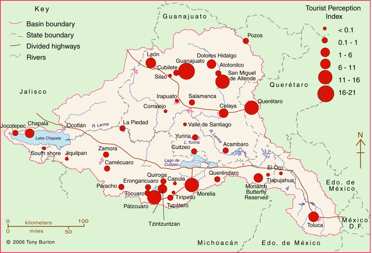
The Lerma-Chapala Basin (see map) is one of Mexico’s major river systems, comprising portions of 127 municipalities in five states: México, Querétaro, Michoacán, Guanajuato and Jalisco. The basin has considerable economic importance. It occupies only 2.9% of Mexico’s total landmass, but is home to 9.3% of Mexico’s total population, and its economic activities account for 11.5% of national GDP. It also has considerable importance for tourism.

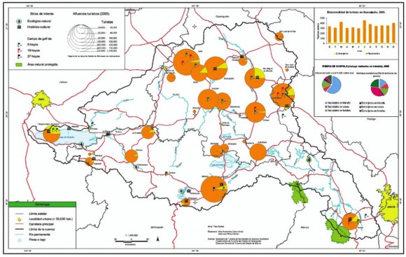
Lerma Basin Tourist Perception Index.

Lerma Basin Tourist Perception Index. Cartography: Tony Burton / Geo-Mexico; all rights reserved Click to enlarge.

The red circles superimposed on the map represent an index of tourism perception. This index is based on an analysis of seven tourist guides that purport to cover the entire country:

  • AAA Tourbook (2004)
  • Let’s Go Mexico (2004)
  • Lonely Planet (2002)
  • Footprint Guide (1999)
  • Upclose Mexico (1998)
  • Insight Guide (1994)
  • Cadogan Guide (1991)

In each case, the total number of lines of text in the guide devoted to any location within the Lerma-Chapala drainage basin was counted, as well as the number of lines devoted to each individual location. This allowed a ratio or percentage to be worked out for each place for each book. For example, if a book had 240 lines in total devoted to the drainage basin, of which 60 were devoted to San Miguel de Allende, the perception index for San Miguel for that book would be 60/240 * 100 = 25%. Similar calculations were performed for all the locations mentioned, for each book, and then the mean index was calculated for each location. These mean indices were the basis for the size of the circles on the map.

In broad terms, the map shows which places are likely to be on a foreign traveler’s radar when they are visiting the area. Those familiar with this area may be surprised to see that the ghost town of Pozos merits as many lines of text as Quiroga (and indeed more lines of text than Atotonilco). Another surprise is that Tzintzuntzan appears to be as much in the tourist eye as Chapala, Dolores Hidalgo or Toluca. The main purpose of this post is not to analyse such apparent anomalies but only to suggest a relatively easy way of analysing tourist perceptions through the use of tourist-oriented literature. Applying the same method to the entire country, on a state-by-state basis, throws up far more interesting anomalies which we plan to share at some point in the future.

Related posts:
Related posts:
Aug 232014
 

Mangrove swamps have an undeserved reputation for being impenetrable thickets harboring noxious insects and reptiles. But they also have considerable value, in terms of both ecology and economics, as this case study of the Marismas Nacionales mangroves on the west coast of Mexico will demonstrate.

Map showing location of Marismas Nacionales

Map showing location of Marismas Nacionales

The Teacapán-Agua Brava-Marismas Nacionales Lagoon System extends northwards along Mexico’s Pacific Coast from San Blas in Nayarit to the southern part of Sinaloa. It is one of Mexico’s largest areas of mangroves. The total area of mangroves in the Marismas Nacionales is estimated at 58,100 hectares (224.3 square miles). Four species of mangroves are found here:

  • black mangrove (Avicennia germinans)
  • white mangrove (Laguncularia racemosa)
  • red mangrove (Rhizophora mangle)
  • button mangrove (Conocarpus erectus)

Mangroves in Mexico are estimated to be disappearing at a rate of at least 2% per year, though the available evidence suggests that the Marismas Nacionales mangroves are relatively undisturbed.

A 2012 study, undertaken by a group of Stanford Students for the Ocean Innovations Environmental Defense Fund considered the ecosystem services provided by Mexico’s largest area of mangroves, the Teacapán-Agua Brava-Marismas Nacionales Lagoon System of Nayarit and southern Sinaloa and attempted to calculate the mangroves’ carbon sequestration potential.

The ecosystem services considered included:

  • fisheries for shrimp, mollusk, fish and crustaceans.,
  • aquaculture (primarily shrimp), forestry (charcoal, firewood, wood and roofing materials),
  • agriculture,
  • coastal protection (mangrove roots help bind unstable coasts, preventing erosion and providing a natural barrier against hurricanes),
  • habitat for other species (breeding, shelter and feeding places for fish, crustaceans and birds) and
  • ecotourism (as in Mexcaltitán)
Mezcatitlán

Mezcatitlán, island settlement in Nayarit

The report tries to quantify the value of each of these services. For example, it finds that the total annual revenue brought in by coastal fisheries alone around Marismas Nacionales (including shrimp, catfish, crabs and sharks) almost certainly exceeds $10.8 million.

In terms of carbon storage, the study took into account the carbon sequestered in the form of biomass (as a result of photosynthesis) as well as the carbon exported from the ecosystem via processes such as respiration, sediment burial and mineralization. The total Net Ecosystem Production (NEP) of carbon in the Marismas Nacionales was calculated to be 8 metric tons of carbon/ha/yr or about 470,000 metric tons/yr for the entire area.

Reference:

  • Marismas Nacionales Conservation & Carbon Sequestration Study. Preliminary Report (pdf file)

Related posts:
 

Aug 162014
 

Tourism associated with rivers and lakes

So far as tourism is concerned, Lake Chapala is far more important than the other bodies of water within the basin. Only limited recreational activities are practiced in the various man-made reservoirs and in lakes Yuriria and Cuitzeo. Tourism is locally important in Zirahuén the most pristine of the basins lakes, but its small area restricts development prospects. Tourism, including ecotourism, is also locally important in Lake Pátzcuaro, with pronounced seasonal peaks corresponding to school vacations and the annual Night of the Dead. Surprisingly, there are no specialized ecotourism services at Lake Chapala.

Lerma-Chapala Basin

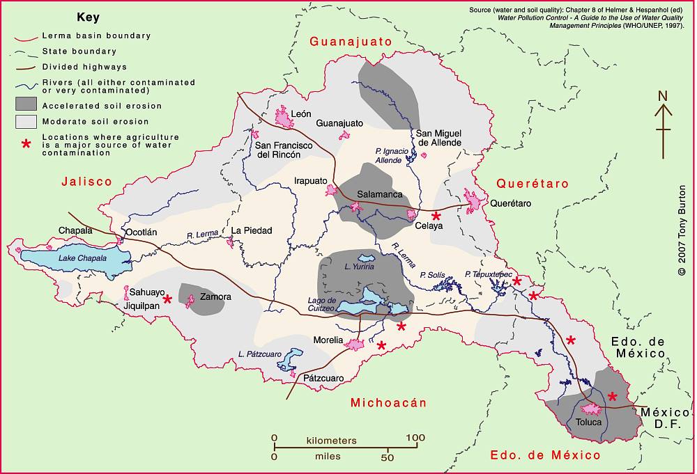
Lerma-Chapala Basin. Cartography: Tony Burton/Geo-Mexico; all rights reserved

The map shows areas of soil degradation in the Lerma-Chapala basin, as well as the locations where agriculture is a major source of water contamination. The environmental impacts of tourism in the basin are concentrated in the major cities such as Guanajuato, San Miguel de Allende and León, as well as in the smaller communities where tourism is of particular importance, such as Chapala and Pátzcuaro.

The lakes in the basin, especially Chapala, have always had more significance than the rivers for recreation and tourism activities. In the nineteenth century, sail canoes plied the waters of Lake Chapala. Fluctuating lake levels since the 1950s have prevented any concerted effort to establish modern water sports (yachting, water-skiing, windsurfing) on the lake, though casual users can be seen sporadically, mainly at weekends and during school holidays. Recreational fishing is virtually non-existent in the basin. Boatmen and fishermen often have conflicting demands.

Potential for ecotourism

Environmental degradation throughout the basin has reduced the number of potential ecotourism locations. The few remaining natural habitats are in urgent need of effective conservation. None of the few small areas of the basin currently protected at a federal level is associated directly with the River Lerma or Lake Chapala. Several tourism hot spots are under extreme pressure, operating at close to carrying capacity (defined as the maximum number of visitors they can handle without adverse environmental impacts). They include the Monarch butterfly reserves, Lake Camécuaro National Park, and the island of Janitzio in Lake Pátzcuaro. Well managed tourism could help finance habitat restoration and protection. Successful planning will require considerable local participation.

Lovers of flora and fauna want to see native and endemic species, rather than imported exotics. Bird-watching is one of the fastest growing recreational activities in the U.S., a huge niche tourism market in a wildlife watching industry worth 10 billion dollars in North America (Stap, 2002). In the basin, bird-watchers have the opportunity to see several endemics, as well as spectacular flocks of the White Pelican (Pelecanus erythrorhynchos), which can be better viewed on the relatively undeveloped southern shore of Lake Chapala than in its breeding grounds far to the north.

The development of horse-back riding, hiking and walking trails holds considerable potential for the future. Niche markets, such as cultural, shopping and eco-tours could all be further developed. Most tourists prefer a mix of experiences; the basin offers numerous, varied tourism possibilities.

Historically, hunting was an important activity in certain areas, particularly in the marshes at the eastern end of Lake Chapala (the ciénega). One ecological issue here, aside from any need to manage wildlife numbers, is the gradual decomposition of the lead-rich cartridges used a century ago. While this needs further study, this is gradually leaching lead into the environment, but is not the only source of the elevated levels of lead that have been reported in fish and lirio samples (Jay & Ford in Hansen & Van Afferden, 127). Careful monitoring is needed to ensure that no health risk is posed to humans.

Tourism exacerbates existing demands for limited supplies of water. This needs to be recognized in tourist-oriented cities such as San Miguel de Allende, Guanajuato and Pátzcuaro. Some recreational and tourism developments are more water demanding than others. Large expanses of grass cause high losses of water through evapo-transpiration especially during the dry season when watering is needed if grass is to be kept green. However, in the rainy season, grass promotes higher infiltration rates, enhancing groundwater recharge. Pressure from public and private gardens for water could be significantly reduced by xeriscaping.

Management is also needed to ensure that chemicals used in gardens, hotel grounds, and hotels do not cause pollution. The misuse of fertilizers and pesticides can have serious deleterious environmental effects. Overfertilization, for example, can increase nitrogen and phosphorus loads on watercourses, promoting eutrophication.

Golf can be one of the least environmentally sound of all recreational activities (Elkington & Hailes 1992). Constructing a golf course may involve habitat destruction and loss of wildlife; its maintenance may require copious quantities of water and agro-chemicals. A single course may use 330,000 cubic meters of water a year, as much as 4,500 people (Walsh, 2004) Aside from the ethical issue of whether water should be allocated to the playgrounds of the rich while the poor go without, golf courses can greatly reduce water consumption with careful design and management. Of Mexico’s 200+ golf courses, at least 23 are located in the basin. Several were built in the past twenty years. Several others are still in the planning stages. More golf courses may attract more retirees and tourists, but decision makers need to consider the possible social and environmental effects of constructing more courses.

References:

  • Hansen, Anne M. & van Afferden, Manfred (ed). The Lerma-Lake Chapala Watershed: Evaluation and Management. New York: Kluwer Academic / Plenum Publishers. 2001.
  • Elkington, John & Julia Hailes. Holidays that don’t cost the earth. The guide to greener holidays. London: Victor Gollancz Ltd. 1992.
  • Stap, Don. “Great Florida Birding Trail” in Audubon Magazine September, 2002.
  • Walsh, J. “War over water”. Golf Course News, October 2004. G.I.Media. 2004

Source:

This post is based on my contribution (on tourism) to the Atlas de la cuenca Lerma-Chapala, construyendo una visión conjunta, published by Semarnat-UNAM-IE, Mexico, in 2006. (The link is to a low-resolution pdf of the entire atlas).

Related posts:
Day trips and tourism in the Lerma-Chapala basin

 Other  Comments Off on Day trips and tourism in the Lerma-Chapala basin
Aug 072014
 

An earlier post looked at the significant impacts of the estimated 10,000 to 15,000 residential tourists (non-working, non-Mexicans) living part or full-time in the Lerma-Chapala basin. These residential tourists are concentrated in San Miguel de Allende and in the Chapala-Ajijic area on Lake Chapala:

Day trips and regular tourism are also important activities in the Lerma-Chapala basin. Both day trippers and tourists bring economic, social, cultural and environmental benefits, but may also create adverse impacts. Conflicts between tourism and other activities are increasing as demographic and environmental pressures rise.

Day trips

By definition, day trips last less than 24 hours. Most day trips are to a single destination, usually only a relatively short distance from home. Within the Lerma-Chapala basin, certain day trip flows stand out. The strong flow of day-trippers from Guadalajara to Chapala-Ajijic peaks on Saturdays, Sundays and public holidays. Day trippers account for about two-thirds of the total number of visitors to Chapala-Ajijic. Day trip flows linking San Miguel de Allende, Dolores Hidalgo and Guanajuato, and between Morelia and Pátzcuaro are also important. Elsewhere, the Monarch butterfly reserves have seasonal importance as day trip destinations; for example, El Rosario, the most visited reserve, attracts up to 5,000 visitors a day between early December and late March.

Tourism

Tourism, on the other hand, involves overnight stays. A typical tourist trip lasts between 3 and 8 days. Tourism may involve multiple destinations, further away from home. In Mexico, national tourists are more numerous, but, on average, earn less, spend less, and stay a shorter time, than international tourists.

In the Lerma-Chapala basin, tourism began to flourish at the end of the nineteenth century, alongside improvements in transportation, especially the building of railways. The shores of Lake Chapala were an early magnet for the wealthy. Developers redesigned the unplanned fishing villages, attracting visitors from all over Mexico. Even today, the Chapala landscape reflects the historical and cultural influences which have influenced it.

Other parts of the basin also became important tourist destinations. The colonial cities route, taking in San Miguel de Allende, Guanajuato, Morelia, Pátzcuaro and Querétaro, is a prime example, which has been very successfully marketed.

Quantifying tourism in the basin is difficult. Official tourism statistics are based on surveys, but these data have their limitations. The size of the circles on the map below represents the total number of tourists visiting each location in 2005, according to Tourism Secretariat figures. The yellow segment represents the percentage of tourists that are international. atlas-tourist-numbers-2The map shows that tourism is heavily concentrated at a small number of locations close to the boundary of the basin: Morelia, Toluca, Querétaro, San Miguel de Allende, Guanajuato and Chapala-Ajijic. Foreign tourists are particularly important in Toluca, San Miguel de Allende and Chapala-Ajijic. The precise numbers should be treated with caution. Many tourists visiting San Miguel and Chapala-Ajijic (but not Toluca) do not stay in hotels but in “Bed and Breakfasts” or with friends or relatives.

Tourism planning needs to consider strategies which:

  • preserve existing and potential natural attractions and historic sites.
  • increase the number and variety of locations visited by tourists.
  • reduce the pronounced seasonality of existing tourism.
  • increase the average length of stay and expenditure of tourists.

Source:

This post is based on my contribution (on tourism) to the Atlas de la cuenca Lerma-Chapala, construyendo una visión conjunta, published by Semarnat-UNAM-IE, Mexico, in 2006. (The link is to a low-resolution pdf of the entire atlas).

Related posts:
The Magic Town of Tzintzuntzan in Michoacán

 Other  Comments Off on The Magic Town of Tzintzuntzan in Michoacán
Jul 262014
 

Tzintzuntzan, designated a Magic Town in 2012, has two sixteenth century churches, equally ancient olive trees, a craft market specializing in straw goods and ornaments, plus an archaeological site which was the capital of the not inconsiderable Tarascan Empire.

The Tarascan Empire

The Tarascan Empire, contemporaneous with that of the Aztecs, stretched westwards as far as the shores of Lake Chapala, with sporadic contacts into the Sayula lake area, and to the east as far as present-day Zitácuaro. The Tarascans spoke Purépecha, and today the local indigenous people prefer to be called Purépecha. The term “Tarascan” is more properly reserved for their ancestors and their pre-Columbian empire.

“Tzintzuntzan” is an onomatopoeic Purépecha rendering of the sound made by a hummingbird. The ceremonial center was still fully active when the Spanish arrived. Tarascan buildings were constructed mainly of wood. Only the basements were normally built of stone and today, therefore, it is only these basements or yácatas that remain. Some of the cut stones which cover the rubble-filled interiors of the yácatas are ornamented with rock carvings.

The scale of earth-moving involved in constructing the temples is remarkable. The entire 425-meter-long platform is man-made. On it were built five yácatas, on the tops of which would have been wooden and thatch structures serving as shrines. The semi-circular shape of these yácatas suggests that they were built to honor the god of the wind, Ik. The Tarascan ceremonial centre commands a magnificent view over the lake, whose waters would have been lapping at the platform’s base during some rainy seasons. The area behind the yácatas, next to the village soccer pitch blazes with color during the wildflower seasons of late spring and early autumn. The archaeological site has a small, modern museum.

The Tarascans had a mixed economy, collecting fruits and forest products, fishing and undertaking agriculture, complete with terracing and irrigation. Some archaeologists have argued that many of the pre-Columbian peoples, dependent on the natural world for their immediate survival, were very ecologically-conscious. However, in this area, evidence from rates of lake sedimentation now suggests that maybe they weren’t quite so environmentally-aware after all. It seems that erosion rates were already on the rise by the time the Spanish arrived, suggesting that native agriculture was almost certainly not sustainable. Following the introduction of European diseases, the decline in population (and agricultural workforce) prompted a further increase in erosion rates as soil conservation methods could not be maintained. Erosion and sedimentation were exacerbated by the nineteenth and twentieth century deforestation of surrounding hills.

Spanish churches

Tzintzuntzan monastery and church. Artist: Mark Eager. All rights reserved.

Tzintzuntzan monastery and church. Artist: Mark Eager. All rights reserved.

The Spanish destroyed the Tarascan temples, carting off many of the stones to build Catholic churches in their new village. Observant visitors to the beautifully-proportioned patio of the former monastery beside the main church will spot petroglyphs on some of the walls there which betray the stones’ earlier placement in the yácatas. This building, decorated with fine old colored frescoes depicting Franciscan lore, and with parts of its original wooden roof still intact, houses the office of the parish notary and is not always open to the public.

There are other peculiarities here, too, which say much for the realities of sixteenth century Spanish monastic life. When the monastery of Tzintzuntzan was built, two churches were constructed, one for the monks’ private use and the other for the lay Third Order. These two churches, only a few steps apart, are about as different as can be, given that they are of similar age. The monks’ church, beautifully restored following an arson attack, is light and airy; the Third Order church is dark, gloomy and oppressing. Both, in their own way, are awe-inspiring. To one side of the Third Order church is a complete-immersion font, shaded by two tall trees.

Ancient olive trees

In the large atrium in front of the monastery are a sixteenth century cross and the bent and twisted tree trunks of some of the oldest olive trees in Mexico, brought by special request from Spain for the express purpose of providing the monks with one of their accustomed foods. They are thought to be more than four hundred and fifty years old.

Handicraft market

Tzintzuntzan’s handicraft market is a cornucopia of straw work in every conceivable color, design and size, which make ideal Christmas decorations or gifts. Also on sale are elaborately carved wooden beams, and examples of the many different local pottery styles including the Ocumicho devil-figures and strange green pineapples as well as finely detailed, hand-embroidered scenes of village life.

How to get there:

Tzintzuntzan is about twenty minutes drive from Pátzcuaro.

Source:

This post is based on chapter 32 of my “Western Mexico: A Traveler’s Treasury” (link is to Amazon’s “Look Inside” feature), also available as either a Kindle edition or Kobo ebook.

The Magic Town of Tacámbaro in Michoácan

 Other  Comments Off on The Magic Town of Tacámbaro in Michoácan
Jul 052014
 

The interesting, but unpretentious, town of Tacámbaro in Michoacán was awarded Magic Town status in 2012. The town has a population of around 26,000 and is located at an elevation of 1650 meters above mean sea level on the edge of Mexico’s tierra caliente. Its full formal name is Tacámbaro de Codallos, so-named to honor a Venezuelan who defended federalism in the early years of Mexico’s Independence.

tacambaro

Among the tourist highlights of this Magic Town, set in the midst of stunning mountain scenery, are:

  • The town center. Despite a serious town center fire a few years ago, there is plenty to see here, including an old chapel around the corner from the main church.
  • The Hotel-Restaurant El Molino (The Mill) located near the entrance to the town. The main restaurant building is a converted, museum-piece nineteenth century flour mill, complete with grinding wheels. Simply and artistically decorated and furnished, this hotel-restaurant has an excellent fixed-price mid-day meal (comida) with subtle sauces and a varied menu.

Though not normally open to the public, a few minutes outside Tacámbaro, is the private hacienda-studio of master printer Juan Pascoe. Pascoe produces superb quality, limited collectible editions, using one of the oldest printing presses still in operation anywhere in the world: an R. Hoe Washington handpress dating back to 1838.

Historical links to Belgium

One of the more curious incidents in local Tacámbaro history is the so-called “Pardon of the Belgians” in 1865.

Belgian forces on the side of Maximilian, under Major Tydgat, were under siege in Tacámbaro on April 11, 1865. They chose to take several Republican families hostage, including the wife and three children of Nicolás de Régules, the Liberal general who was in charge of the Juarist (Republican) forces attacking the city. When Republican lieutenants realized that the hostages included the family of their general, they first requested orders for their troops to change course and avoid attacking the city, but the general answered, “Men, to your posts! Everyone has to do his duty. The Fatherland comes first!”

Later in the ensuing fighting, in a last ditch effort to prevent defeat, the Belgians produced the family of de Régules and placed them directly in the line of fire. Even that did not stop de Régules who ordered his troops to keep fighting and to take as many prisoners alive as possible. After the battle was over, de Régules had taken more than 300 prisoners, but had not taken revenge for the killing of his family. What a noble act!

The events in Tacámbaro are commemorated by monuments in two Belgian cities: Beverlo and Audenarde.

How to get there:

Tacámbaro is about an hour’s drive from the city of Morelia, the capital of Michoacán state. Follow the Morelia-Pátzcuaro highway westwards, exiting at Tiripetío (“place of gold”), where a former Augustinian college of higher studies, one of the earliest in the Americas, founded in 1537, has been restored and now houses an invaluable historical archive. From Tiripetío, follow signs for Villa Madero, and then Tacámbaro.

Back to the drawing board for US-Chinese tourism project near Cabo Pulmo

 Mexico's geography in the Press  Comments Off on Back to the drawing board for US-Chinese tourism project near Cabo Pulmo
Jun 232014
 

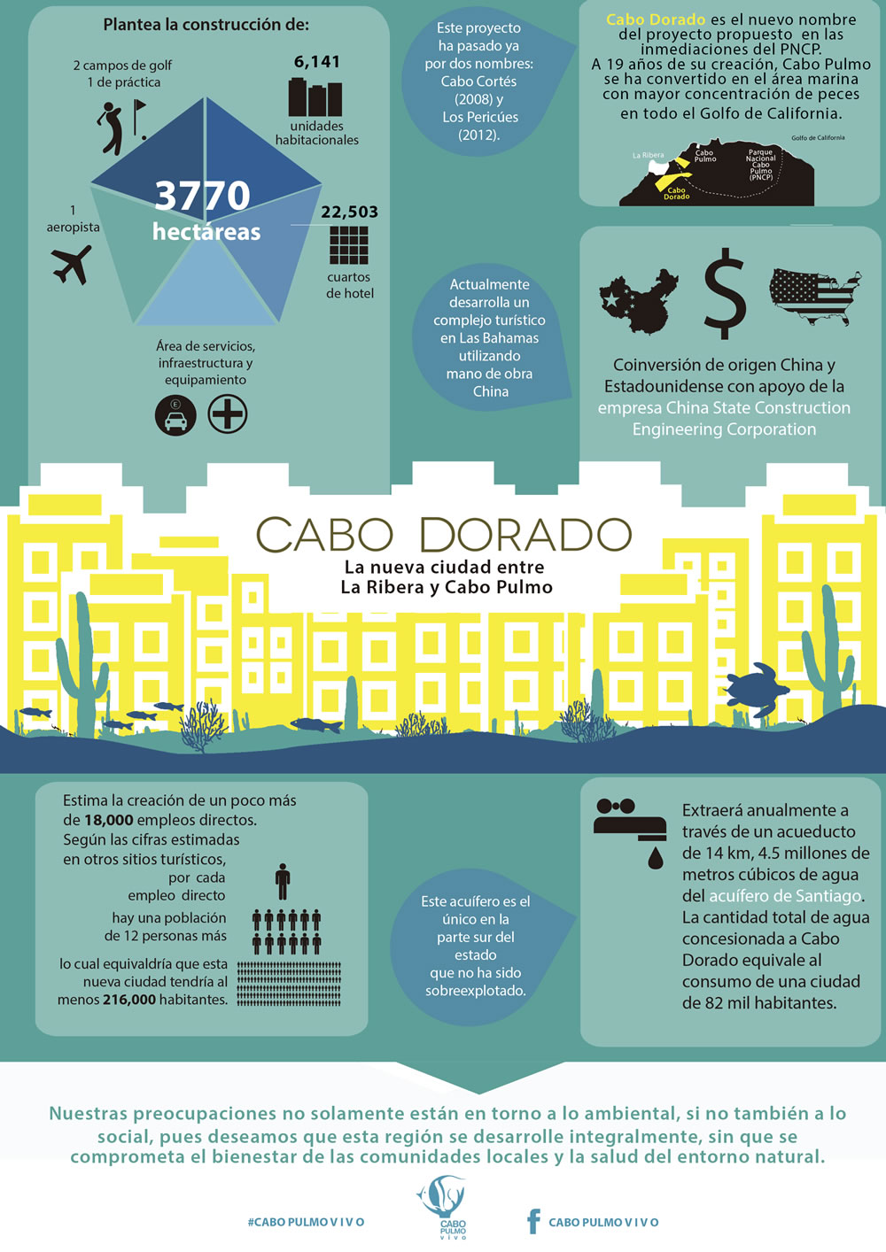
Good news for Cabo Pulmo, the marine park in Baja California Sur! Cabo Pulmo is a 7,111-hectare (17,550-acre) marine reserve that boasts the best-preserved coral reef in Mexico’s Pacific region. The proposed tourist megaproject known as Cabo Dorado on the edge of the park has been shelved, at least for now.

The US-Chinese joint venture behind Cabo Dorado said it is halting plans to build the tourist development due to the “well-founded” criticism of environmental groups. [See New threat to Cabo Pulmo National Marine Park] The $3.6 billion project was to have included construction of thousands of hotel guestrooms in the area where another giant development project, Cabo Cortés, had been planned. The Cabo Cortés project was cancelled by government officials on the grounds of environmental concerns.

The firms behind Cabo Dorado are Glorious Earth Group (USA) and Beijing Sansong International Trade Group (China), together with China State Construction Engineering Corporation. The initial proposal was for a project involving the construction of a new “ecotourist city” on 3770 hectares (9317 acres) of land, including 6,141 homes,9 hotels, 2 golf courses, a landing strip, shops and a convention center.

The group has now halted its initial environmental-impact study of the Cabo Dorado project, with the intention of resuming this procedure in the near future with a new project “that meticulously takes into account the well-founded criticisms that have been expressed and which we’ve listened to carefully and with the utmost respect”.

Related posts:
Medical tourism and the medical equipment industry in Mexico

 Other  Comments Off on Medical tourism and the medical equipment industry in Mexico
Jun 212014
 

Mexico is both a growing market for medical tourism and a world leader for the manufacture of medical equipment.

Growing market for medical tourism

The global market for medical tourism in 2013 was estimated to be worth about $2.847 billion, with some 7 million patients seeking medical treatment outside their home country each year. According to Patients without Borders, a U.S. business that specializes in the field, Mexico is currently the second most popular destination for medical tourists, after Thailand. Nationwide, Mexico has more than 71,000 doctors working in hospitals and private clinics. Almost two-thirds of all doctors in Mexico are specialists, compared to an average of 57.7% for all OECD member nations.

Mexico’s Economy Secretariat estimates that, combined, the one million medical tourists in 2013 and the numerous affiliated services such as spas, massages and non-conventional therapies, contributed $4.2 billion to the national economy. This figure is growing at about 7% a year.

Patients without Borders claims that patients from the USA and Canada pay between 36 and 80% less for operations and medical treatments in Mexico than the cost in their home country. The most important states for medical tourism are Nuevo León, Baja California, Baja California Sur, Sonora, Tamaulipas, Chihuahua, Jalisco, Quintana Roo and Yucatán.

A plan to build a new “medical city” has been announced by health officials in Quintana Roo. It would be called “Jardines de la Sabiduría” (Gardens of Wisdom) and located on a 550-hectare lot between Cancún and Puerto Morelos. The new city would have four zones: residential, hospitals, recreation and cultural/educational, and would include at least four hospitals: for children, cancer care, dental work and orthopedic surgeries respectively. It remains to be seen if sufficient foreign investment can be found to bring this project to fruition.

World leader for medical equipment

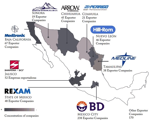
Mexico is a major manufacturer of medical devices. Sales of Mexican-made medical equipment exceed $10.6 billion a year and are predicted to reach $14.9 billion by 2020. Manufacturing costs for medical devices in Mexico average 25% below those in the USA, the world’s largest market for such products.

Major medical device manufacturing areas in Mexico

Major medical device manufacturing areas in Mexico. Credit: Economy Secretariat.

Mexico’s exports of medical equipment and supplies were worth $6.2 billion in 2011, making Mexico by far the largest exporter of medical devices in Latin America, and the 11th largest in the world. 92 % of medical devices manufactured in Mexico are exported to the USA, accounting for two-thirds of all U.S. imports of those products.

According to Pro-Mexico, Mexico is the world’s largest exporter of bore needles; the 4th largest exporter of medical, surgical, dental and veterinary furniture; the 5th largest exporter worldwide of medical,surgical, dental and veterinary instruments and apparatus; and the 7th largest exporter worldwide of ozone therapy, oxygen therapy, aerosol therapy apparatus, breathing apparatus and other respiratory therapy apparatus.

More than 2,000 separate businesses, and about 135,000 workers help invent, design and manufacture medical devices in Mexico. Medical device manufacturing is concentrated mainly in northern border states, especially Baja California, where the cluster of more than 60 specialist firms includes Smiths, Tyco Healthcare, Cardinal Health, Medtronic, Gambro, ICU Medical, CLP, Sunrise Medical and North Safety Products.

Data:

  • The Medical Device Industry, 2012 (Pro-Mexico; pdf file)

Related posts:

Jun 022014
 

This engaging book analyses the historical geography of the port of San Blas, on Mexico’s west coast, and its hinterland which includes the small city of Tepic, the state capital of Nayarit. This area held immense importance during colonial times, was one of the main gateways for trade and influence peddling during the nineteenth century, before lapsing into relative obscurity at the end of the that century, and into the twentieth century. The tourism industry has sparked a mini-revival but none of the many grandiose plans for this coast have even been brought fully to fruition.

richter-coverThe Camino Real in Richter’s title is actually a branch from the Camino Real de Tierra Adentro (The Inland Royal Road, the spine of the colonial road system in New Spain). During colonial times, this linked the inland city of Guadalajara to Tepic and thence San Blas, though the modern highways uniting these places no longer follow the same route.

Robert Richter has known this area personally for decades, and his intimate knowledge of the local geography shines through. The book combines his own personal experiences with intensive historical research, both in the library and on the ground. Richter’s objective is to pin down the precise route of the Camino Real, and then find every remaining vestige of it that he can on the ground.

In reading the story of San Blas and the Camino Real, readers are treated to a dazzling array of insights into what made this area tick for so long before subsiding into something of a backwater. This branch of the Camino Real, from Guadalajara to San Blas, played a key role in the history of Western Mexico, and saw everything from pirates and adventurers to soldiers, priests and smugglers.

As Richter points out, “The Matanchen Bay-San Blas region grew in geographic and strategic importance to become the most important Pacific seaport between Guayaquil, Ecuador, and San Francisco, California, in the 1830s, a major international way station for both legal and contraband trade between an ungovernable Mexico and the rest of the world.”

This growth continued and, “In the 1850s, the cultural, economic, and political events roiling all along the Camino Real from San Blas to Guadalajara, especially in the mild sierra valley surrounding the city of Tepic, spawned a new regional identity, and eventually, a new political entity—the Mexican state of Nayarit.”

Richter tells his story with passion and it is impossible not to be drawn into the narrative and share his excitement as he sets out to find “missing” sections of the Camino Real, accompanied by a motley crew of secondary characters. To what extend does he succeed? Sorry, no spoilers here!

Inevitably, the past merges with the present and the future. What began as a seemingly straightforward historical geography becomes at turns a travelogue, journal of fieldwork and short essay about the sustainability of economic development along this coast. Richter is clearly not against change, but argues strongly that local tourist development in the future must take account and respect the region’s ecology, its history and its culture.

As the back cover blurb aptly states, “To explore Nayarit’s wild and gorgeous geography, trying to site the ancient Camino Real, is to stumble over another road running toward the state’s future economic development as part of the Mexican Riviera.”

This book should be of interest to geographers everywhere. It serves to prove that historical geography need not be dull and stuffy but can be made relevant, exciting and even entertaining, at the same time as it offers us valuable insights into possible futures.

One minor plea: please add an index when the second edition of this book is prepared!

Search for the Camino Real, a history of San Bad and the road to get there” is one of several books by Richter centered on the fading coastal village culture of Nayarit and the Mexican Riviera. His adventure novel, “Something like a Dream” (Oak Tree Press, 2014) is an especially entertaining read, with a lively plot and well-described settings ranging from the tourist resort of Puerto Vallarta to Nayarit fishing villages and tiny Huichol Indian settlements high in the Western Sierra Madre.

Map of the beaches of Colima, Jalisco and Nayarit, Mexico shows the location of all the key places mentioned in Richter’s books.

Related posts:
May 092014
 

We have repeatedly questioned the long-term wisdom of large-scale tourist developments along Mexico’s coastline. See, for example:

The good news, in June 2012, was that it looked as if the conflict at Cabo Pulmo, in Baja California Sur, had been resolved in favor of protecting the environment:

Unfortunately, land developers won’t take “No” for an answer. Immediately after its “cancellation”, the Cabo Cortés project was renamed Los Pericúes and relaunched, with few if any differences from the original version. Two years on, the project has been taken over by a new consortium of developers and renamed “Cabo Dorado”. Some changes have been made along the way, and Cabo Dorado no longer includes a marina or desalination plant, and its plans appear to have a lower building density.

There are still some legitimate concerns about the long-term impact of such a project in this area, so kudos to Carolina Herrera (Latin America Advocate of the Natural Resources Defense Council in Washington DC) for her impassioned plea calling for Cabo Pulmo to be protected from the latest incarnation of this long-proposed tourist megaproject.

The project is located immediately north of the Cabo Pulmo Marine Park, which over its 19 year lifespan has proven to be hugely successful in conservation terms (The extraordinary ecological recovery of Mexico’s Cabo Pulmo Marine Park), while providing local people with the opportunity to offer a variety of alternative forms of low impact tourism. The site of the Cabo Dorado project site is home to 26 “at risk” species, including endemic plants and endangered sea turtles.

Cabo Dorado is a 3.6-bilion-dollar joint investment by La Rivera Desarrollos BCS, a joint venture of Glorious Earth Group (USA) and Beijing Sansong International Trade Group (China), together with China State Construction Engineering Corporation.

The project is for the construction of a new “ecotourist city” on 3770 hectares (9317 acres) of land. Slightly more than two-thirds of this area will be retained as a “conservation reserve”.

The master plan for the developed third includes:

  • 6,141 homes  (443 ha)
  • 9 hotels with 4,080 hotel rooms (721 ha) [the 22,503 number on the infographic below is an error]
  • 2 golf courses and practice ground (162 ha)
  • Services, infrastructure, maintenance (334 ha)
  • 1 landing strip
  • 1 14-km aqueduct
  • Shops, convention center, etc
Infographic from www.cabopulmovivo.org

Infographic from www.cabopulmovivo.org   Click to enlarge

According to the developers. Cabo Dorado “will be a fully integrated development, a first of its kind in the country, as it combines educational, recreational activities, scientific research, health promotional centers and a strong commitment to preserve the environment.” To this end, the project includes “an interpretation center, a technological and biological research center for studies related to the Sea of Cortes and the Desert of Baja California Sur, as well as a cultural exchange center, an educational institute and a student campus. In addition, there will be centers dedicated to the promotion of trade and investments, a high performance sports center, 9 world-class hotels and residences for temporary visitors and full time residents.”

Cabo Dorado will extract up to 4.8 million cubic meters of water a year from Santiago aquifer, roughly equivalent to the water needs of a city of 82,000 people) and will generate 711,900 kilograms of waste per day.

On the positive side, the project will create 18,000 direct and indirect jobs and bring around 900 million dollars/year into this area. It does not involve a marina or pumping wastewater into the sea which should prevent direct adverse ecological impact on marine life. The masterplan includes a “support town” for workers, which means that the local municipality does not need to build additional infrastructure to support the project.

The Mexican Center for Environmental Law (CEMDA) has called for a formal public meeting and consultation to ensure people are adequately informed about the latest plans and the potential social and environmental impacts.

Further reading:

For an exceptionally informative series of papers (in Spanish) on all aspects of tourism and sustainability in Cabo Pulmo, see Tourism and sustainability in Cabo Pulmo, published in 2008 (large pdf file).

Related posts:

The resort city of Cancún continues to grow

 Updates to Geo-Mexico  Comments Off on The resort city of Cancún continues to grow
Apr 232014
 

The resort of Cancún in Quintana Roo is celebrating its 44th birthday this year. Local officials have arranged a series of events between 19 and 27 April, including an exhibition of vintage cars, to mark the occasion.

The construction of the purpose-built resort Cancún, planned by the Federal Tourism Development Agency FONATUR, began in 1970:

The tourist part of the city has thrived. Cancún now has more than 3000 condominium units, luxury shopping centers, restaurants, museums, discos, bars, an international airport and more than 150 hotels, with 35,087 hotel rooms.

In 2013, some 14 million visitors passed through the airport. Hotels had a profitable 2013, with an average room occupancy of 77.2%. Visitors to Cancún contributed an estimated 4.36 billion dollars to the local economy. Tourism provides direct employment in Cancún for around 52,600 people, and indirect employment for 175,000.

Cancún by Arthur Gonoretzky (Flickr)

Cancún by Arthur Gonoretzky (Flickr)

There is a less rosy side to Cancún. Besides the obvious adverse impacts of so many tourists, there are many other issues arising from the extraordinarily rapid growth of tourism in this area. For example, see Beach erosion in the tourist resort of Cancún, Mexico.

For a fuller discussion of the issues associated with 40 years of tourist development in Cancún, see “Ending a Touristic Destination in Four Decades: Cancun’s Creation, Peak and Agony“, which appeared in a 2013 special issue of the International Journal of Humanities and Social Science.

Tourism aside, perhaps the biggest single issue is in the “regular” city of Cancún (as opposed to the tourist zone). Cancún city (2010 population: 628,000, but sometimes claimed now to be more like 800,000) is where most supporting services are located, and most workers live. The city has grown so fast that it lacks sufficient services and fails to offer a good quality of life for its residents.

Related posts:

The Magic Town of Jiquilpan in Michoacán

 Other  Comments Off on The Magic Town of Jiquilpan in Michoacán
Apr 102014
 

For a small Mexican town of somewhat nondescript architecture, Jiquilpan de Juárez, in Michoacán, has considerable claim to fame, well deserving of its Magic Town status. Jiquilpan is the birthplace of two Mexican Presidents, who played pivotal roles in national affairs, and several distinguished artists. Its unprepossessing exterior appearance offers no hint of the important works of art—including sculptures and a singular mural—which are to be discovered in the town.

The first former President associated with the town is Anastacio Bustamante, who had the distinction of being President three times 1830-32, 1837-39, 1839-41). In the interim between his first two governments, Mexico was forced to cede a large part of its territory, including Texas, to the USA. Bustamante, considered one of the more honest nineteenth century politicians, seized power for the first time in 1830, overthrowing Vicente Guerrero. He was in turn overthrown by Santa Anna in 1832, and fled to England. On resuming office in 1837, after the rather unsavory incidents which robbed Mexico of Texas, Bustamante immediately faced the “Pastry War” crisis.

The Pastry War began when Mexico refused to pay compensation for damages to a pastry shop, owned by a Frenchman in Mexico City. The shop had allegedly been looted during riots in 1828. Ten years later, the French government used this pretext, and other losses which had occurred at the same time to other French property, to demand 600,000 dollars in damages from the Mexican government of Bustamante. The French also sought a preferential trading agreement with Mexico. Bustamante considered the claim for looted pastries to be preposterous and refused either to pay, or to consider the trade agreement. Outraged, the French brought up a fleet from the Caribbean island of Martinique and blockaded Veracruz. Seven months later, the French added a further 200,000 dollars to their demand to cover the costs of the blockade. Bustamante finally gave in and paid in full, whereupon the French fleet sailed off.

The second former President associated with  Jiquilpan is Lázaro Cárdenas, born in the town on the 21st May, 1895. As national President (1934–40), he presided over a massive agrarian reform program and in 1938 nationalized the railways and the oil industry. He was the last President to be held in sufficient esteem to occupy important ministerial posts including Defense Secretary after the end of his term as President.

jiquilpan-sm2On Jiquilpan’s main street, appropriately named Avenida Lázaro Cárdenas, are the library and the town museum. During Lázaro Cárdenas’ presidency, a nineteenth century church in Jiquilpan was converted to a library and embellished with two impressive works of art. The new door of the library, in which are sculpted the heads of 22 of the most outstanding figures of the early twentieth century, was designed by Guillermo Ruiz. It is a beautiful tribute to the greatest thinkers and scientists of the time (Edison, Marti, etc.).

The murals decorating the interior of the library were painted by an even more prominent figure in the history of Mexican art: José Clemente Orozco, one of the famous “Big Three” of Mexican Muralism, alongside Diego Rivera and David Alfaro Siqueiros. Orozco painted, literally singlehandedly (having lost his left hand in a childhood accident) a series of sketchy black-and-white murals depicting political parties and revolutionary Mexico on either side of the former nave and an unusual and striking full-color, nationalistic mural known as “A Mexican Allegory”.

The modern Jiquilpan museum, east of the town center beyond the very friendly Hotel Palmira, includes a collection of archaeological pieces unearthed from a nearby shaft tomb. In addition to the archaeological pieces, the museum houses the Centre for Studies of the Mexican Revolution. Even non-Spanish speakers can gain insights into the turbulent and complex times that comprise the Mexican Revolution by looking at the extensive photographic exhibition on the museum’s first floor. The exhibition details the life and works not only of Lázaro Cárdenas but also of other key figures in twentieth century Mexican politics including General Francisco Múgica, who was in the group which proposed for inclusion in the Constitution of 1917 (still current today) Article 27, which encompassed agrarian reform and land redistribution, and Article 123 which dealt with the rights of workers, including an eight-hour day and guaranteed minimum wages. The museum in Jiquilpan is a fitting tribute to these much revered politicians.

Moving away from politics and towards the arts, Jiquilpan was the birthplace of artist Feliciano Béjar, who passed away in 2007, and received national acclaim for his inspiring sculptures, painting and weaving. Rafael Méndez, arguably the world’s greatest ever trumpet virtuoso, was born into a musical family in Jiquilpan and later moved to the USA. His legendary technique and tone have never been equaled. Jiquilpan hosted an international trumpet festival named for him in 2011.

Elsewhere in Jiquilpan are a statue of Christ on the Cross, said to date from the times of Emperor Charles V (now in San Francisco church), and a fountain sculpted by Francisco Eduardo Tresguerras, Mexico’s most famous nineteenth century sculptor and architect. This fountain was originally on the El Cabezón hacienda, owned by the Cañedo family, in Jalisco, but the family later gave it to Lázaro Cárdenas to beautify his native town. Known as “The Fisherman’s Fountain” (Pila de los Pescadores), it is a few blocks from the main plaza. Another, newer fountain on the plaza, “La Aguadora” (The Water Carrier), commemorates the first anniversary of the nationalization of the oil industry.

The ancient hieroglyph for Jiquilpan, from pre-Columbian times, is a horizontal line of earth with two indigo plants above it, linking the town to the color blue. One of Jiquilpan’s most famous poets, Ramón Martínez Ocaranza, also linked his birthplace to the color blue, christening it, “the city of jacarandas”, a tag that quickly caught on and is still used today. Anyone who drives through the town during jacaranda season (February–March) will certainly agree that the tall trees  with their lavender-blue blossoms bordering the main avenues are a magnificent sight.

Note: This is a lightly edited excerpt from chapter 6 of my Western Mexico: A Traveler’s Treasury (Sombrero Books, 2013)

Related posts:

Mexico’s geomorphosites: Ceboruco Volcano

 Other  Comments Off on Mexico’s geomorphosites: Ceboruco Volcano
Apr 072014
 

A short distance west of the crater lake of Santa María del Oro, in the west Mexico state of Nayarit, is Ceboruco volcano which has a cobblestone road to the top. The road starts from the old and picturesque village of Jala, eight kilometers off the main highway (Highway 15). The cornfields around Jala yield some of the largest ears of corn in the world, more than 30 centimeters (one foot) in length, a cause for celebration in the village’s annual August festival. Jala was declared a Magic Town in 2012.

The road up Ceboruco is a geologist’s or biologist’s dream come true, a slowly unfolding series of volcanic forms and different types of vegetation with abundant surprises even for the scientifically expert. Small wonder, then, that the great German botanist Karl Theodor Hartweg was so impressed with Ceboruco when he collected plants here in the nineteenth century. To read more about his discoveries, see The geography of garden flowers, many of which originated in Mexico.

ceborucoNear the top are several short but interesting walks, some in shady, thickly vegetated valleys hidden between towering walls of blocky lava, some along the many overlapping rims of the various old craters of which this complex peak is comprised. Wherever you choose to walk, a multicolored profusion of flowers and butterflies will greet your eyes.

On the south side of an attractive grassy valley at kilometer sixteen, fumaroles send hot gases and steam high into the air reminding us that this volcano is not yet irrevocably extinct. A massive Plinian eruption in about the year 1000 sent ash plumes into the air and devastated a wide area around the volcano. The huge blocks of lava near the summit date from a prolonged series of eruptions in the early 1870s.

Highway 15 cuts through Ceboruco’s lava field a few kilometers after the Jala junction. For those not wishing to brave the cobblestone road up to the volcano, this is a good place to stretch the legs and marvel at the inhospitable, black lava blocks which were spewed out more than a hundred years ago.

This is a lightly edited extract from my “Western Mexico: A Traveler’s Treasury” (link is to Amazon’s “Look Inside” feature), also available as either a Kindle edition or Kobo ebook.

Want to read more about Mexico’s geomorphosites? The link uses Geo-Mexico’s “Site Search” feature.

Related posts:

Apr 032014
 

Geo-Mexico agrees entirely with Joseph Kerski (a key member of ESRI’s Education Team), that it is amazing “how little American students really know about their neighbor to the south.” In order to help remedy this situation, ESRI’s Witold Fraczek has created a series of online “story maps” about Mexico. The maps can be accessed in several different ways, including as an ArcGIS Online presentation and an iPad iBook, or via this webpage.

The six stories are entitled:

Each “story” includes several maps (covering topics such as population, landforms, climate, historical landmarks, caves, indigenous cultures, tourist attractions), some of which are interactive in the sense that clicking on a marked point brings up a pop-up panel with a photograph and/or additional information about that place. The maps, linked by short commentary notes, can be viewed at a variety of scales.

This series of maps has many strong points, and could certainly be useful in some geography classes, but it also has some weaknesses that should be taken into account when using them. Brief comments follow on each of the six stories.

1 Explore Mexico (Crime vs. Tourism)

The first map in this mini-series depicts “tourism attraction density” based on “650 major points of interest”. No clues are offered as to how the 650 points were selected, and indeed, some can not really be shown by points on a map since they cover larger areas. The map appears to weight all 650 points equally, though some are major, major tourist attractions (like the pyramids of Teotihuacan) that attract thousands of visitors a day, while others are very much less significant.

The second map, showing the “20 cities with most murders” uses data from 2011 (now out-dated) to conclude that “crime, measured by the total number of murders” appears to be “spatially isolated from the areas most attractive to tourists”. Surely murder rates (per 100,000 people) are a better measure than the number of murders in each city?

Murder rate per 100,000 is used as the basis for comparing Mexico with its regional neighbors, but Mexico is so large (and the murder rates across the country so varied) that comparisons at this scale mean relatively little, especially when some of the nations are tiny Caribbean islands, where one or two murders extra in any year can mean a significant spike in their murder rate.

2. Mexico’s Natural Wonders

The introductory text to this section rightly highlights how “the natural world of Mexico varies amazingly, from tropical jungles and coral reefs to deserts and glaciers.”

However, the statement that “Central Mexico is home to billions of Monarch Butterflies, whose 2 year /4 generation long trip to Canada and back amazes both scientists and the general public” is misleading. First, there may be millions of Monarch Butterflies, but there are not billions. Secondly, not all Monarch Butterflies migrate. Thirdly, those that do migrate are part of an annual (1 year) cycle involving 4 or 5 generations, not a two year cycle.

The text later claims that the Monarch Butterfly reserves “are located on old volcanic hills covered with pine-oak forest”. Actually, they overwinter in pine-fir forests. Mexico’s pine-oak woodlands occur only at much lower elevations.

The only birds incorporated into Mexico’s “biological wonders” are its pink flamingos, yet there are dozens of other bird species that are equally worthy of inclusion. Fortunately, the texts accompanying the maps of caves and cenotes (sinkholes), waterfalls, volcanoes, canyons and geologic sites appear to be much more accurate.

Screenshot from ESRI's story maps of Mexico.

Screenshot of ESRI’s story maps of Mexico.

3. Historical monuments

This section includes a useful map of Mexico’s World Heritage sites, though absent (from both the declared sites and the proposed sites) is the El Pinacate and Gran Desierto de Altar Biosphere Reserve in Sonora, which in June 2013 became Mexico’s 32nd World Heritage Site.

The great weakness of the maps of “archaeological sites” and “missions and monasteries” is that no clues are given as to how and why particular locations were selected for inclusion. This leads to some anomalies in the distribution. For example, Oaxaca is almost a no-show for “missions and monasteries” according to the map, despite such buildings being the subject of an excellent and extensive book by Richard Perry published as long ago as 2006, Exploring Colonial Oaxaca: The Art and Architecture.

The map of Magic Towns is also a useful map, though many more towns have been added to the list since 2012.

4. Geography of Mexico – Did You Know?

This series of maps will be quite useful to many classes as a quick way to introduce the basic physical and settlement geography of the country. Maps of relief and precipitation are accompanied by one of time zones and a simple map of states (though these are not named on the “map story” version) and major cities.

The introductory text to this section claims that “the array of Mexican volcanoes stretches along the same latitude as the volcanoes of Hawaii. Analogously, those located at the eastern ends are the newest and highest.” This may be true for Hawaii, but is not the case for Mexico. There is no simple pattern to the heights of Mexico’s major volcanoes, and certainly those in the east are not significantly younger than those in the west.

5. Indigenous People of Mexico

The single map in this section attempts to show the location of about 25 of Mexico’s many indigenous groups. The colors chosen for each group are in many cases confusingly similar, though the names of each group do appear as you zoom in on parts of the map.

The introductory text makes a strong case for Mexico’s attractiveness to tourists, yet concludes with the strange (and unanswered) question, “So why isn’t Mexico a major tourist destination?” Mexicans would beg to differ. Mexico is a major tourist destination. In 2013, for example, it received 23.7 million international visitors who spent 13.8 billion dollars. In fact, Mexico is ranked #11 in the world in terms of tourist arrivals (and that number excludes the 70 million or so border tourists each year).

6. Cartograms of Mexico

The cartograms in the last section certainly add interest to the map stories, but the basis of the “travelers attractiveness” map (those 650 tourist attractions again) means that the map is not a very good reflection of tourist numbers across the country. The significance of the State of Mexico is greatly exaggerated, while states such as Quintana Roo (with the resort of Cancún) and Baja California Sur (with Los Cabos) fail to stand out.

The final “fictional map” purports to portray Mexico as perceived by Californians. Based on the author’s personal impressions, in some ways this is the single most interesting map in the entire collection!

All in all, these maps are a mixed bag. The idea behind them is great, as is the decision to produce them in a flexible GIS system. If the details were refined a little, and more explanation offered about the basis for selecting places for inclusion, they would be even more useful in geography classes, and might go some way towards helping American students gain a better appreciation for their southern neighbor.

Mar 242014
 

According to Eduardo Barroso, the CEO of management consultancy EB Turismo, in his presentation at the XII Foro Nacional de Turismo held in Mérida, Yucatán, in February 2014, Mexico’s 83 Magic Towns (Pueblos Mágicos) attracted more than 4 million visitors in 2013, and tourist spending of more than 6 billion pesos (460 million dollars). However, he also pointed out that the program has not been prudently and carefully developed, but has been distorted by the designation of 46 Magic Towns in just two years (2011 and 2012), compared to the designation of just 37 Magic Towns in the preceding decade. (The Magic Town program started in 2001.)

Magic TownsThe Tourism Secretary Claudia Ruiz Massieu has called a halt to the program while officials work out how to reinstate it in a manner that will ensure that only towns worthy of the designation can actually acquire the status. This will no doubt require establishing new guidelines and regulations governing the program.

Success stories for the Magic Town program include San Miguel de Allende, which was first designated a Magic Town but has since been elevated to the much more exalted status of a World Heritage City;  Real de Catorce, in San Luis Potosí, which has seen visitor numbers jump by 1200% in only 12 years; and the town of Tequila, in Jalisco, where the coordination of three levels of government has seen visitor numbers quickly rise from 18,000 to 165,000 visitors a year.

Related posts:

Cosmic botanical garden in Toluca

 Other  Comments Off on Cosmic botanical garden in Toluca
Mar 152014
 

The city of Toluca (population 1.8 million), the capital of the State of México, was in the news recently as the site for the tri-national meeting between the heads of state of Mexico, the USA and Canada to mark the 20th anniversary of NAFTA.

Nestled away inside the city, away from its burgeoning factories, is the former city market. The market closed in 1975. Plans to demolish it were forestalled when renowned Mexican artist Leopoldo Flores stepped up with a plan to restore the market building, which dated back to 1909, into an artistic gem housing a botanical garden.

Cosmovitral, Toluca

Used under Creative Commons Attribution-Share Alike attribution

The market’s original windows were replaced with large glass murals, comprised of half a million pieces of glass and covering a total area of more than 3,000 square meters. The revamped building, now known as the Cosmovitral, was reopened in 1980. In 2007, the Cosmovitral narrowly missed being named one of the 13 man-made wonders of Mexico.

The centerpiece of the Cosmovitral murals is the stunning image entitled Sun Man (Hombre Sol).

Possibly the world’s best decorated glasshouse, the Cosmovitral houses over 500 different plants from around the world and has become one of the city’s single most popular tourist attractions, though rarely visited by foreign tourists.

Where? The Cosmovitral is located in downtown Toluca at the intersection of Juárez and Lerdo de Tejada streets. Guided tours are available.

When? It is normally open Tuesday to Saturday, 10 a.m. to 6 p.m.; Sundays 10 a.m. to 3 p.m.

Admission? Tickets are 10 pesos (less than a dollar) for adults, 5 pesos for children. Guided tours, mostly to explain the Cosmovitral’s stained glass, are available. Art exhibitions are hosted regularly.

Related posts: