climate | Geo-Mexico, the geography of Mexico - Part 3

Cement production in Mexico

 Other  Comments Off on Cement production in Mexico
Nov 032012
 

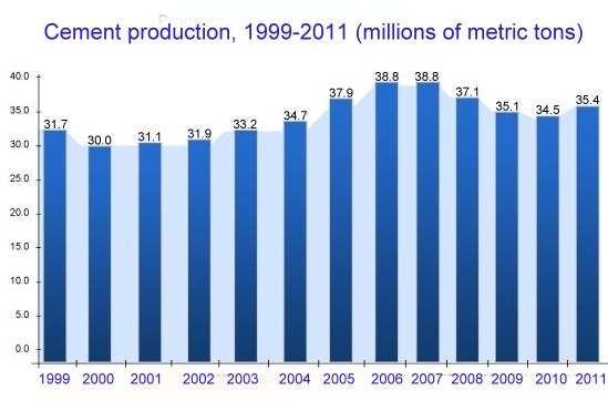
In 2011, Mexico produced 35.4 million tons of cement, 3% more than a year earlier. The first cement-making plant was built in Mexico in 1906, a few years after cement was first officially approved for use in the construction sector. Cement demand grew only slowly prior to a spate of public infrastructure projects in the mid 1940s.

Cement production in Mexico, 1999-2011

Cement production in Mexico, 1999-2011. Source: Camara Nacional de Cemento

There are currently six major cement makers in Mexico. About 20% of production is sold in bulk to large construction companies. The remaining 80% of production is sold in 50-kg bags, used either by formal residential construction firms (50% of the total) or in informal (do-it-yourself) projects (32% of all purchases).

Cemex holds a 49% share of the domestic market, followed by Holcim Apasco (21%), Cruz Azul (16%), Cementos Moctezuma (10%). The remaining 4% is split between Cementos Chihuahua and Lafarge Cementos. A seventh company, Cementos Fortaleza (part-owned by Carlos Slim, the world’s richest man), is due to open early next year.

Cemex, based in Monterrey, is one of Mexico’s most important multinational companies. It is the world’s third largest cement producer and distributor, with operations in fifty countries worldwide. In 2004 Cemex received the Wharton Infosys Business Transformation Award for its creative and efficient use of information technology. Before Cemex, who had ever heard of cement mixers, armed with GPS devices, satellite links and computer systems hooked up via satellite links to the parent company’s HQ, cruising cities? The strategy allowed the company to achieve enviable levels of operating efficiency while meeting demanding delivery deadlines even in congested urban areas such as Mexico City.

China leads the world in terms of the volume of cement production, making around 2,000 million metric tons (mmt) a year, followed by India (710 mmt), Iran (72), USA (68), Turkey (64), Brazil (63) and Russia (52). Mexico (35.4) places 15th on the list, behind Japan, South Korea, Egypt and Thailand, but ahead of Germany, Indonesia, France, Canada, the UK and Spain.

On a per person basis, annual cement consumption in Mexico is about 300 kg/person, well below the levels recorded in the USA (1100 kg) and elsewhere. (The extreme cement consumer in recent years has been Dubai, with the staggering figure of 8000 kg/person!) Cement production may be a good indicator of how much construction is taking place, but is not very good news for the environment and climate change, since high quantities of carbon dioxide are released into the atmosphere during the production process. Globally, cement making is responsible for up to 10% of people’s total carbon dioxide emissions each year.

The carbon dioxide comes from three distinct sources:

  • During the conversion of raw materials into clinker
  • From the combustion of fuels needed in the cement kilns
  • Indirectly, from producing the energy required to power production machinery such as grinders and electric motors.

However, according to the Center for Clean Air Policy’s Sector-based Approaches Case Study: Mexico,

“Mexico’s cement industry is among the most modern and efficient in the world today. All the 50-plus kilns operating in the country’s 34 cement plants are dry-process. Mexico’s cement manufacturers are also using energy efficiency enhancing technologies such as preheaters and precalciners in many of their facilities. Moreover, a number of plants make use of some forms of low carbon alternative fuels.”

“Between 1992 and 2003, emissions of CO2 by the cement industry in Mexico increased roughly 25%. This compares with a nearly 108% increase in cement sector emissions from all developing countries during that same time frame and a 34% increase in U.S. cement industry emissions. The relatively slow growth of emissions from Mexico’s cement sector is an indication of the high overall efficiency of the sector.”

A future post will look at the location of cement plants in Mexico.
The geography of Mexico’s street markets (tianguis)

 Other  Comments Off on The geography of Mexico’s street markets (tianguis)
Oct 082012
 

Mexico has some of the finest markets in the world. The variety of produce and other items sold in markets is staggering. But not all Mexican markets are the same. The two major groups are the permanent markets (mercados), usually housed in a purpose-built structure and open for business every day, and the street market or tianguis, usually held once a week.

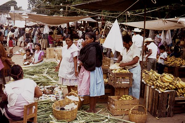
Street market in Oaxaca. Photo: Tony Burton

Street market in Oaxaca. Photo: Tony Burton

Most tianguis temporarily occupy one or more streets or a public square, though some also use privately-owned land. The origins of the tianguis lie in pre-Columbian times, whereas mercados are a much more recent innovation. In this post, we focus on the tianguis.

The geography of a street market or tianguis

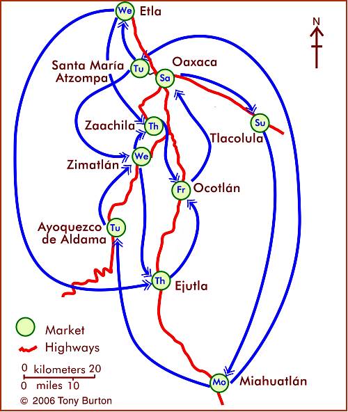
The merchants selling goods in a street market generally visit several markets each week, on a regular rotation (see map for an example of a weekly cycle of markets around the city of Oaxaca). In terms of economic geography, weekly markets allow merchants to maximize their “sphere of influence” and exceed the sales “threshold”, the minimum sales required for them to make a profit, even if they are selling items that may not cost very much, and for which individual consumers are not prepared to travel very far. By visiting, say, four markets a week, these merchants effectively quadruple their potential customers. In terms of social and human geography, these weekly markets are a valuable means of communication, and news from one community quickly travels, via the merchants, to another.

At the same time, these markets give consumers access to a much wider range of goods than would otherwise be possible.

The map shows the market day for major markets, and the major weekly marketing cycles, in the area around the city of Oaxaca. With the exception of Oaxaca city (population 480,000) and Miahuatlán (33,000), all the other towns have populations between 13,000 and 20,000. The merchants at such markets generally carry their wares from village to village on the days of their respective markets. Some local farmers also sell their produce at such markets. For more details, see Markets in and near the city of Oaxaca.

The weekly cycle of markets in and around the city of Oaxaca, Mexico. Map: Tony Burton. All rights reserved.

Mexico has a very long history of street markets, certainly dating back more than two thousand years. The Spanish conquistadors saw, first hand, the very large market of Tlatelolco, in what is now Mexico City, which attracted between 40,000 and 45,000 people on “market day”, which was held every five days.

Markets enabled people living in one region to trade goods produced in another region. In the case of food items this allowed residents of the “hot lands” (tierra caliente) to gain access to food items coming from the “temperate lands” (tierra templada). Some ancient settlements in Mexico are located close to the division between either tierra caliente and tierra templada [usual elevation about 750 meters above sea level] or tierra templada and “cold lands” (tierra fria), at an elevation of about 1800 meters a.s.l. These locations clearly favored the trading and exchanging of items from one major climate zone to another.

Food was by no means the only item traded in markets. Many plants with medicinal value were traded, as were others used for construction materials. It was also common to trade textiles, minerals and household items such as baskets, ceramics and grinding stones, as well as salt, prized feathers and animals.

Even today, most Mexican markets have a distinctive spatial pattern of stalls, with vendors of similar items setting up side-by-side, allowing for comparison shopping. It is a relatively easy and revealing fieldwork exercise to map a Mexican market and then analyze the distribution of different kinds of goods.

We looked in a previous post at how the same basic principle applies to the distribution of shops in many towns and cities.

While most markets traded a variety of items, a handful of specialist markets emerged, especially in the Mexico City area. For example, there were specialist markets for salt in Atenantitlan, dogs (as a source of food) in Acolman, and for slaves in Azcapotzalco and Iztocan.

In a future post, we will look at the origins of the tianguis in the Oaxaca region, a region that is still one of the most fascinating areas in Mexico for markets of all kinds.

Further reading:

Related posts:

Oct 062012
 

Considerable attention has been focused on Mexico’s obesity problem (see “Soft drinks, obesity, diabetes and public health in Mexico”). Obesity in adults is defined by the World Health Organization (WHO) as a Body Mass Index (BMI) greater than or equal to 30, where BMI is defined as a person’s weight in kilograms divided by the square of his height in meters (kg/m2).

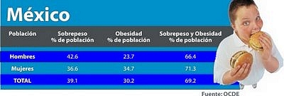
Mexico’s very high adult obesity rate of 30% is increasing every year. It is related to many factors, including increased consumption of processed fat and sugary foods. The average daily calories consumed by Mexican adults increased from 3102 in 1988 to 3266 in 2007.

Rates of "overweight" and "obese" adults in Mexico

Rates of “overweight” and “obese” adults in Mexico

Addressing Mexico’s serious obesity problem will require significant effort and dramatic behavioral change, first and foremost by families, but also by schools, government, industry and civic organizations. Most agree that long term solutions for limiting or reducing obesity should focus primary on children and youth. Obviously physical exercise and diet are crucial parts of a solution. Fortunately Mexico is already making efforts to address its child obesity problem (see “Mexico takes on childhood obesity”).

Obesity is quite complicated and may involve numerous heretofore unknown factors. The data are sometimes confusing. For example, Italian adults, with an obesity rate of only 10%, consumed on average a whooping 3646 calories per day in 2007, 380 more than Mexicans, whose obesity rate is three times that of Italy. (The data in this and the next paragraph come from Table 1 of the Milken Institute’s “Waistlines of the World”, August 2012). French adults consume far more calories than Mexican adults, and more fat the US adults, but their obesity rate is much lower, at only 11%. Furthermore, the French consume 50% more alcohol than Americans and almost three times more than Mexicans and yet they are much thinner. Though adults in Norway consume more calories than Mexicans (3169 versus 3102) their obesity rate is only a third that of Mexico (10% versus 30%). Obviously calorie intake is not the only factor and may not be the most important factor.

Mexican Manuel Uribe, one of the world's most obese individuals, enjoys a snack

Mexican Manuel Uribe (1965-2014), one of the world’s most obese individuals, succeeded in lowering his weight from 560 kg (1233 lbs) to 394 kg (867 lbs).

Obesity is also related to amount of physical activity, but here again the data are confusing. New Zealand adults have a high obesity rate of 27% though they live in one of the physically most active countries, with 49% engaging in “moderate physical activity” defined as light-to moderate activity for at least 30 minutes five times per week. On the other hand, only 27% of the relatively thin Italian adults engage in “moderate physical activity”. Why are obesity rates for the more active New Zealanders so much higher than those for the less active Italians, especially since the latter consume 544 more calories per day (3646 versus 3129)? By way of comparison, only 21% of Mexican and 23% of US adults engage in “moderate physical activity”.

How does Mexico’s growing obesity problem compare that of other countries? Data compiled by the World Health Organization (used by Procon.org to compile “US and Global Obesity Levels: The Fat Chart)”) and the OECD in “Waistlines of the World provide a basis for comparing obesity rates in numerous countries (though see note [1] for reservations about using data from different years).

Country % obese Year of data
Saudi Arabia 35.6 2000
USA 33.8 2008
Egypt 30.3 2006
MEXICO 30.0 2006
Australia 26.4 2007
Canada 24.2 2008
U.K. 23.0 2009
Chile 21.9 2003
South Africa 21.6 1998
Germany 14.7 2009
Colombia 13.7 2007
France 11.2 2008
Brazil 11.1 2003
Italy 10.3 2009
China 5.7 2008
Japan 3.9 2009
South Korea 3.8 2009
Eritrea 3.3 2004
Indonesia 2.4 2001
India 1.9 2008

The data indicate that Mexico ranks 12th of 88 countries with an adult obesity rate of 30%, defined as body mass index (BMI) of over 30. While 12th of 88 does not sound so bad, the top six on the list are small island countries with obesity rates from 41% to 79% (Nauru, American Samoa, Tokelau, Tonga, Kiribati and French Polynesia). Also higher than Mexico are the relatively small countries of Panama and the United Arab Emirates. If these small countries are excluded then Mexico ranks 4th among major countries behind only Saudi Arabia, the USA and Egypt (see table).

Mexico trails several notable countries with high obesity rates between 20% and 30% such as Australia, Canada, UK, Chile and South Africa. (Given that obesity rates are increasing almost everywhere and South Africa’s data are from 1998, its current obesity rate is probably closer to 25% or more.)

The global data suggest that the obesity problem is most serious in Pacific Island nations, North America and the Middle East (including North Africa). It is also becoming a problem in several European and Latin American countries. It is less of a problem in Asia and Sub-Sahara Africa.

In conclusion, obesity is a very serious problem for Mexico today, and arguably one of the biggest problems facing humanity in the 21st century along with climate change and poverty.

Note [1]:

There are some significant differences between the WHO and OECD data sets. For example the WHO data for Mexico are from 2000 while the OECD data are from 2006. For our comparisons we use the most recent data available from the two data sets. Though obesity is an extremely important international problem, reliable data is not collected frequently in many countries. Obesity rates are based on measured height and weight, and are invariably higher than rates based on self reported height and weight. In our table, measured values are used for: the USA, Mexico, Australia, Canada, UK, Japan and South Korea; we are not sure about the rates for other countries.

Update

For an updated post on this topic, with more data, please see: Mexico the 4th most obese country in the world

The Teziutlán disaster of 5 October 1999, a case study of vulnerability

 Other  Comments Off on The Teziutlán disaster of 5 October 1999, a case study of vulnerability
Oct 042012
 

Today marks the 13th anniversary of a major disaster that struck Teziutlán (current population about 65,000), a small city in the Eastern Sierra Madre, in the northeast corner of the state of Puebla, close to the border with Veracruz. The city is noteworthy as the birthplace of two prominent twentieth-century politicians: Manuel Ávila Camacho (served as President, 1940–1946) and Vicente Lombardo Toledano, who founded the Confederación de Trabajadores de México (CTM), Mexico’s largest confederation of labor unions.

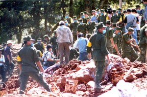
The town’s name means “place of the hailstones”. But in 1999, it was not hailstones but torrential rain that triggered the major disaster of 4/5 October, with parts of the city destroyed by a series of landslides and mudflows. More than 80 municipalities were affected to some degree by this tremendous storm. Hundreds of landslides occurred in Hidalgo, Veracruz and Puebla states, causing an estimated US$457 million worth of damage, and at least 260 deaths.

This post focuses only on the consequences for Teziutlán where several hundred homes were completely destroyed and almost a thousand homes suffered partial damage. More than 100 Teziutlán residents lost their life. The local infrastructure, roads, housing, schools and farming were all severely impacted.

The worst damage was in the La Aurrora district on the eastern side of the city, where a landslide on a 23-degree slope buried more than 130 people. In another district, La Gloria, in the western part of the city, several more slips, flows and slides damaged homes, but without any fatalities.

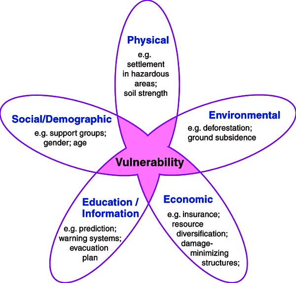
With the benefit of hindsight, this disaster offers a good case study of the factors which made the inhabitants of Teziutlán particularly vulnerable to such an event. The diagram suggests one general classification of the multitude of factors that can affect vulnerability. In the case of Teziutlán, the discussion that follows suggests that the physical factors were probably the most significant.

factors affecting vulnerability

Factors affecting vulnerability (Geo-Mexico, Figure 7.2) All rights reserved.

Physical factors

1. Relief and geology. The area ranges in elevation from 300-2,280 meters above sea level and is drained by the El Calvario, Xóloatl and Xoloco rivers. The city is located at the southern limit of the Eastern Sierra Madre (Sierra Madre Oriental), very close to where it is truncated by the geologically more recent Volcanic Axis. The local geology includes a series of loosely compacted, pumice-rich pyroclastic flows, most of which are thought to be associated with the Los Humeros caldera. These deposits are interlaced with palaeosoils rich in clay which are impermeable and restrict the infiltration of rainwater, and overlie older folded rocks. The combination of steep slopes and impermeable, unconsolidated layers increases the risk of landslides and other forms of mass movement.

2. Climate.  This mountainous region is one of the most humid and foggiest in Mexico, averaging 280 days of mist or fog each year. Teziutlán has an average precipitation of 1600 mm/yr, though totals of over 2000mm are not that uncommon. Most rain falls between July and October.On 4 October 1999, a moist tropical depression off the coast of Veracruz was prevented from moving by a cold front. This led to an increase in humidity followed  by torrential downpours (over 300 mm of rain) over Teziutlán and the surrounding area. The storm continued the next day when a further 360 mm of rain fell.  The rain that fell on just those two days was equivalent to about 40% of Teziutlán’s usual total for an entire year.

3. Earthquake A few days prior to the storm, on 30 September 1999, a 7.4-magnitude earthquake occurred off the coast of Puerto Escondido (Oaxaca). This earthquake did cause  minor cracks in some homes in Teziutlán, and it possibly played a (minor) contributory role in the severity of the storm’s impacts.

Environmental

Deforestation, as a consequence of unplanned urban growth, was also important. Natural and secondary woodlands were steadily being cleared for construction and agriculture. This had an adverse effect on infiltration rates and the capacity of the land to absorb rainwater. However, given the extreme magnitude of the rainfall event, it is unlikely that the area would have escaped unscathed, even if the natural forest had remained.

In the La Aurrora district, where a landslide/mudflow buried more than 130 people, the construction of  a cemetery on a hill above La Aurrora may have played a part, since it appears that a cemetery wall held rainwater back, allowing more of it to seep into the underlying slope, increasing its susceptibility to a serious slide.

La Aurrora, October 1999. Credit: Periódico Sierra Norte

La Aurrora, October 1999. Credit: Periódico Sierra Norte

Educational

The town had suffered severe mass movements during prior storms. For example, in 1955, the rains that accompanied Hurricane Janet provoked numerous mass movements resulting in the disruption of transport systems, including the main highway, but with no loss of life. However, in general, it is clear that these prior events did not increase Teziutlán’s preparedness for a similar event in the future. In particular, prior events did not lead to building regulations being enforced or prevent buildings from being erected in high-risk areas.

Social/Demographic

In the period following the last major event (in 1955), the population of Teziutlán had increased rapidly, leading to the equally rapid expansion of the urban area. This was uncontrolled and included construction on steep slopes with insufficient attention to stability or possible mass movement mitigation measures being taken. It is worth noting that the population has continued to increase rapidly since the disaster, too.

Economic

Home owners in Mexico do not generally carry insurance on their properties, and even when they do, it often specifically excludes major meteorological events. It is unlikely that any of the residents of Teziutlán were able to make insurance claims. Many of the those affected would not have had savings and would have been forced to rely on family, friends and emergency hand-outs to survive. As a 1999 BBC News article emphasizes, government help was slow to arrive.

Want to see more?

There are several Youtube videos with images of the disaster. Perhaps the most interesting is TEZIUTLAN 1999 – 10 años Después del desastre  because it includes some clips from an investigative 1995 TV program aired in 1995 (four years prior to the landslide) that highlighted the extreme risk of constructing unauthorized buildings on the steep slopes of the town along the main highway. This video includes many excellent photos [warning: some graphic images] of the landslide and its aftermath, with a commentary [in Spanish].

Other valuable Youtube resources include Teziutlan Desastre 1999 which has additional photos, plus some eyewitness memories of the event [in Spanish], and TEZIUTLAN historia y tragedia which has many photos of the disaster, accompanied by music only (no commentary) making it a good choice for English-speaking classes.

Sources:

Alcántara-Ayala, I.  Flowing Mountains in Mexico. Mountain Research and Development, Vol 24, No. 1, Feb. 2004: 10-13.

Flores Lorenzo, Pablo & Irasema Alcántara Ayala. Cartografía morfogenética e identificación de procesos de ladera en Teziutlán, Puebla. Boletín del Instituto de Geografía, UNAM. #49, 2002, pp. 7-26. [pdf file]


Case study of a Tarahumara garden

 Books and resources  Comments Off on Case study of a Tarahumara garden
Sep 032012
 

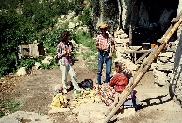
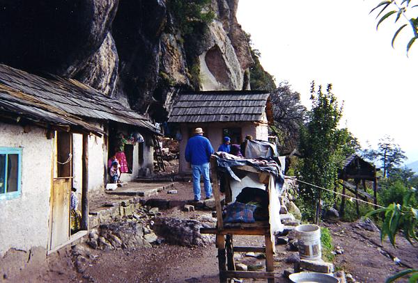
A cave dwelling known as  “Cueva del Chino” is located a short distance from the Posada Barrancas railway halt, very close to the present-day location of the Posada Barrancas Mirador hotel. When I first visited this cave, in the mid-1980s, I was struck by the obvious dangers of living so close to a precipitous drop. The cave is on a very narrow ledge, some 20 meters or so below the canyon rim. There is a local spring which acts as a water supply, though it is perhaps not always a reliable year-round supply. Outside the cave is a tangle of vegetation, much greener and more varied than elsewhere along the canyon wall. It was only on my second or third visit to this cave that I realized that this unruly vegetation was not only due to the nearby natural water source, but also due to the assiduous work of the cave’s residents. The tangled vegetation was actually a very productive garden, offering a variety of vegetables, fruit and herbs.

Accustomed, as most of us are, to the idea of crops and plants in neat orderly rows, the mini-jungle in the cave’s small garden-farm may come as a surprise. But there are sound ecological (and economic) advantages to maintaining, and even encouraging, this apparent disorder. Among the major advantages of mixed cropping (sowing several different crops more or less at random in an area) are the following:

  • (a) some plants are perennial, others annual; hence a ground-cover is maintained all year and the likelihood of soil erosion is diminished
  • (b) taller plants provide shade for shorter plants, offering distinct microclimates within the garden
  • (c) some plants (legumes) help fix nitrogen in the soil; other plants need the nitrogen
  • (d) a variety of plants means a much more varied diet
  • (e) since different crops use different nutrients, the total yield off a small plot is greater with a mix of crops than with a single crop
  • (f) if disease or insects strike one plant, they may not be able to spread to the next plant of that kind
  • (g) if one crop fails for any reason, another may succeed; this may be enough to ward off starvation for another year
  • (h) in terms of energy efficiency, this is a very efficient system, since it involves relatively little labor; the output of energy will exceed the input (see The energy efficiency of farming in Mexico and elsewhere for more details)

Put simply, who really wants to work harder than necessary?

Cueva del Chino, 1989.Copyright Geo-Mexico; all rights reserved.

Cueva del Chino, with “garden” on the left, 1989.Copyright Geo-Mexico; all rights reserved.

Cueva del Chino, 2003.Copyright Geo-Mexico; all rights reserved.

Cueva del Chino, 2003 [from the opposite angle]. Copyright Geo-Mexico; all rights reserved.

The photos show the truly astonishing changes that took place in this cave dwelling and garden between 1989 and 2003. The major change in the area between those years was the construction of the Posada Barrancas Mirador, only a few steps away from the path leading down to the cave. This has led to a steady trickle of visitors who buy the locally-made pine needle basketwork (top photo) or leave behind a few pesos.

Are these changes really for the better? There are arguments on both sides, and I’m honestly not entirely sure. I haven’t been back for several years, but would welcome an update (and photo) from any Geo-Mexico reader who happens to visit.

Related posts:


Aug 022012
 

The rainy season is now well underway in most of Mexico, but large swathes of the north are still experiencing severe drought conditions. For example, the state of Zacatecas was recently officially declared a drought disaster zone. It is still too early to estimate the total economic impact of the drought, but the U.S. Department of Agriculture (USDA) has reported that the drought has already caused agricultural damages in Mexico of $1.2 billion dollars, in addition to the $8 billion dollars of losses for Texas.

The drought has raised many issues connected to trans-border water agreements and flows, with renewed calls for them to be formally reviewed and updated. Two examples should suffice to show the seriousness of the situation.

1. Under the terms of a 1906 bilateral treaty, Mexico is entitled to 74 million cubic meters from the Elephant Butte and Caballo reservoirs in New Mexico. However, according to Adolfo Mata, foreign affairs officer for the U.S. Section of the International Boundary and Water Commission (IBWC), the USA will only be able to deliver a maximum of 18.5 million cubic meters this year.

2. Meanwhile, south of the border, the governor of the state of Chihuahua has stated that his state is unable to meet its obligation to deliver water to the USA under the terms of a 1944 International Water Treaty between the two countries. He said that, “No one can give what they do not have. Chihuahua cannot meet this treaty, not for a lack of will, but because it has not rained,” adding that Chihuahua was the only desert in the world that was expected to export water. According to the governor, the treaty requires that about 80% of the rainfall that Chihuahua receives is exported.

On a more positive note, researchers at the Ibero-American University have announced the development of a hydrogel capable of absorbing 200 times its own weight of water before gradually releasing it. The hydrogel could be a useful additional to the range of drought mitigation measures available for farmers. Climate change scientists predict that northern Mexico will suffer from more frequent and more severe droughts in coming decades.

The hydrogel, which is expected to cost 800 pesos (60 dollars) a kilo when it comes on the market, is a mix of natural gelatine and polyacrylic_acid  Hydrogel can only be used in orchards or other areas where the soil remains undisturbed by regular plowing, so it will not help farmers growing corn or beans, for example. The hydrogel has been tested in citrus orchards in San Luis Potosí, and succeeded in halving the required frequency of irrigation from twice a week to once a week, saving water and reducing energy costs. Each citrus tree required a kilo of hydrogel each year.

Previous posts related to the drought:

Have Mexicans given up on the dream of moving to the USA?

 Updates to Geo-Mexico  Comments Off on Have Mexicans given up on the dream of moving to the USA?
Jul 092012
 

A recent post noted that net migration from Mexico to the USA has dropped to essentially zero. Does this mean that Mexicans no longer have any interest in moving to the USA? The answer to this question is complicated. Obviously, many Mexicans living in Mexico would like to join their family members in the USA if it were legally possible. Others might feel that their career ambitions or the aspirations of their children might be better served by living in the USA. On the other hand, many Mexicans in the USA might feel that their lives would be better if they lived in Mexico.

A face-to-face survey in April 2012 by the Pew Research Center of 1,200 Mexicans in Mexico sheds light on this issue. According to the survey, 56% had a favorable view of the USA, compared to 52% in 2011. Only 34% had an unfavorable view of the USA, down from 41% in 2011. The views varied significantly by age and education. Sixty percent of 18 to 29-year-olds had a positive view compared to only half of those over age 50. Fully 66% of those with a post-secondary education had a favorable view compared to less than half (48%) of those with less education.

Over half (53%) think that Mexicans who move to the USA have a better life, up sharply from 44% in 2011. This suggests that there is still considerable interest in migration. Only 14% indicated they had a worse life, down from 22% a year earlier. However, 61% said they would not move to the USA if they had the means and opportunity. On the other hand, 37% said they would move to the USA and of these 19% indicated they would move even without legal documentation. Not surprisingly, younger Mexicans and those with more education were more interested in moving to the USA.

The survey data indicate that when/if US unemployment declines and there are again ample job opportunities in the USA, many Mexicans may migrate legally or illegally to fill those jobs. Of course, employment opportunities in Mexico will be a very important factor affecting decisions about migration. While the Mexican economy has recovered from the severe recession far better than the USA, still 62% of surveyed Mexicans described the economy as “bad”, down from 75% in 2010 and 68% in 2011. But Mexicans remain optimistic, 51% say the economy will improve in the next year compared to 32% who think it will remain the same, and only 16% who believe it will be worse. The Mexicans more willing to migrate, those with higher educations and incomes, are more optimistic about Mexico’s economic future. If the gap between US and Mexican economic opportunities continues to shrink in the decades ahead, we can expect Mexicans to become less interested in moving to the USA.

Related posts:
Jul 052012
 

By virtue of its geography, the Gulf coast state of Veracruz is one of the best places in the world to see the annual migration of birds of prey (raptors) from North America to Central and South America.

Between 4 and 6 million birds (eagles, hawks, vultures, falcons, and kites) make this trip each way each year to trade the harsh winter and scarce food in one hemisphere for better conditions in the other hemisphere. The migration south takes place September-November, and the return migration passes overhead in March-April.

Since most raptors are relatively large birds, and they are accompanied by other species such as storks, white pelicans and anhingas, this annual migration is one of the most awesome birding spectacles anywhere in the world. Each passing flock contains tens of thousands, in some cases hundreds of thousands, of individuals.

The raptors fly during daylight and rest overnight. Their New World songbird cousins, who also migrate in vast numbers, prefer to feed and rest during the day and then fly at night. Most songbirds take a direct migration route from the eastern USA to Central and South America, flying directly over the Gulf of Mexico in a “single, epic 18-hour flight”. Raptors, on the other hand, prefer a more leisurely approach, leap-frogging along the coastal plain.

Why do they fly through Veracruz?

The main reasons are:

1. Relief: Mexico’s mountain ranges, especially the Sierra Madre Oriental {Eastern Sierra Madre) and Volcanic Axis, funnel the birds towards the east coast, but the Gulf of Mexico provides a natural barrier preventing the birds from attempting routes further to the east. At its narrowest, this funnel is only 25 km (15 miles) wide.

2. Climate: The wide coastal plain warms up sufficiently to provide ascending thermal “bubbles” which help keep these large birds aloft and minimize  the energy expenditure required to soar and fly large distances. Raptors use the thermals to soar to about 1000 meters (3000 feet) above the ground, before gliding in their desired direction of travel gradually losing height until they pick up another thermal at a height of about 300 meters (1000 feet), repeating the process as often as needed. On a good day, they will cover more than 320 km (200 miles) in this fashion before resting for the night.

3. Biogeography: The varied landscape, vegetation and animal life in habitats ranging from tropical wetlands to temperature forests, offers plenty of potential food sources for the raptors.

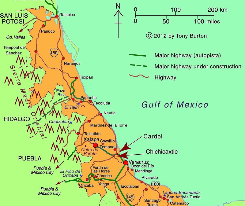
This massive migration has been studied since the early 1990s and scientists continue to tag birds today in order to update their estimates of bird populations and of the precise timing and routes involved. An official counts is held each year from 20 August to 20 November, organized by Pronatura Veracruz. The count is held in two locations: Cardel and Chichicaxtle (see map).

The counts have confirmed that Veracruz hosts the most concentrated raptor migration in the world.

One of the major long-term threats to this migration is habitat change in central Veracruz. Pronatura Veracruz sponsors an environmental education program known as “Rivers of Raptors” which tries to address this issue, helping local landowners appreciate the need for watershed protection and for an end to deforestation.

Pronatura’s work with raptors and the local communities is partially funded by ecotourism, and hawk-watching has become an important component of Mexico’s fledgling “ornithological tourism” market. Other key sites in Mexico for birding tourism include the tropical forests of the Yucatán Peninsula and Chiapas, and the San Blas wetlands in the western state of Nayarit.

Map of Central Veracruz

Map of Central Veracruz; all rights reserved. Click map to enlarge

In fact, Mexico is one of the world’s most important countries for birds, home to 1054 species of birds, 98 of them endemic, including 55 globally threatened species. Mexico has no fewer than 145 recognized “Important Bird Areas” (IBAs) of global significance, which between them cover 12% of the national land area (see summary map below).

Important Bird Areas in Mexico [Birdlife.org]

Important Bird Areas in Mexico [Birdlife.org]

Want to read more about the raptors?

Related posts:


Net migration flow from Mexico to the USA falls close to zero or has possibly reversed

 Books and resources, Updates to Geo-Mexico  Comments Off on Net migration flow from Mexico to the USA falls close to zero or has possibly reversed
Apr 262012
 

The following are extracts from the text of a press release from the Pew Hispanic Center entitled “Net Migration from Mexico Falls to Zero—and Perhaps Less“, by Jeffrey Passel, D’Vera Cohn and Ana Gonzalez-Barrera:

The largest wave of immigration in history from a single country to the United States has come to a standstill. After four decades that brought 12 million current immigrants—more than half of whom came illegally—the net migration flow from Mexico to the United States has stopped—and may have reversed, according to a new analysis by the Pew Hispanic Center of multiple government data sets from both countries. The report is based on the Center’s analysis of data from five different Mexican government sources and four U.S. government sources. [see original article for sources]

The standstill appears to be the result of many factors, including the weakened U.S. job and housing construction markets, heightened border enforcement, a rise in deportations, the growing dangers associated with illegal border crossings, the long-term decline in Mexico’s birth rates and changing economic conditions in Mexico.

Among the report’s key findings:

  • In the five-year period from 2005 to 2010, about 1.4 million Mexicans immigrated to the United States and about 1.4 million Mexican immigrants and their U.S.-born children moved from the United States to Mexico.
  • In the five-year period a decade earlier (1995 to 2000), about 3 million Mexicans had immigrated to the U.S. and fewer than 700,000 Mexicans and their U.S. born-children had moved from the U.S. to Mexico.
  • This sharp downward trend in net migration has led to the first significant decrease in at least two decades in the number of unauthorized Mexican immigrants living in the U.S.—to 6.1 million in 2011, down from a peak of nearly 7 million in 2007.
  • Mexicans now comprise about 58% of the unauthorized immigrants living in the United States. They also account for 30% of all U.S. immigrants.
  • Apprehensions of Mexicans trying to cross the border illegally have plummeted by more than 70% in recent years, from more than 1 million in 2005 to 286,000 in 2011—a likely indication that fewer unauthorized immigrants are trying to cross.
  • As apprehensions at the border have declined, deportations of unauthorized Mexican immigrants—some of them picked up at work or after being arrested for other criminal violations—have risen to record levels. In 2010, nearly 400,000 unauthorized immigrants—73% of them Mexicans—were deported by U.S. authorities.
  • Looking back over the entire span of U.S. history, no country has ever sent as many immigrants to this country as Mexico has in the past four decades. However, when measured not in absolute numbers but as a share of the immigrant population at the time, immigration waves from Germany and Ireland in the late 19th century equaled or exceeded the modern wave from Mexico.

– – – end of quotations from press release – – –

Related posts:

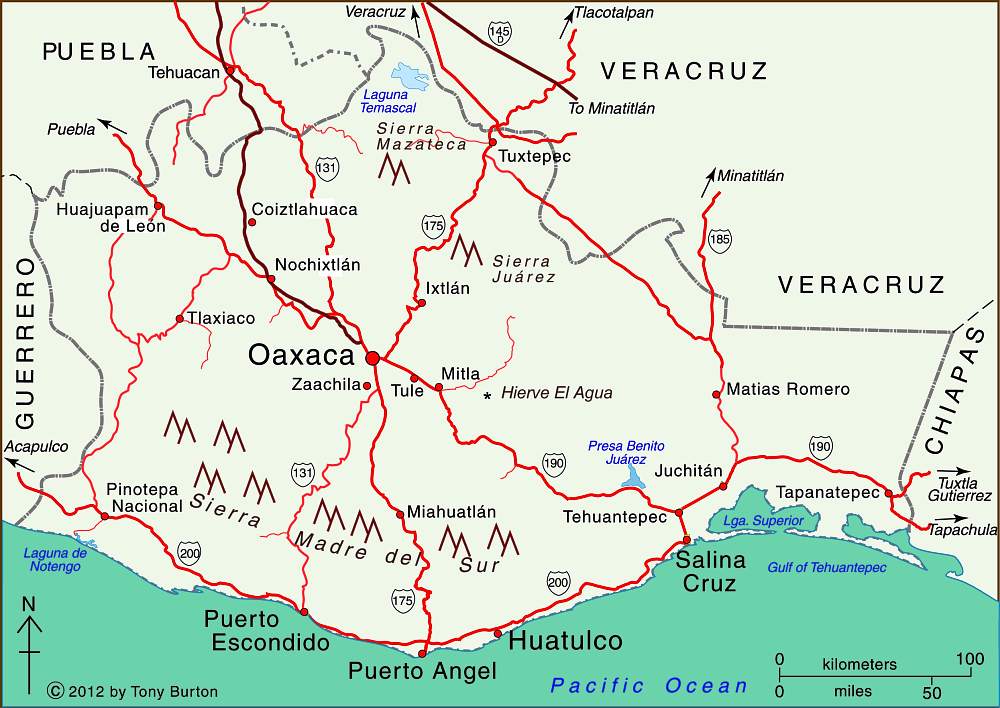
Map of Oaxaca state, with an introduction to its geography

 Maps  Comments Off on Map of Oaxaca state, with an introduction to its geography
Mar 122012
 

The state of Oaxaca is Mexico’s fifth largest state, with an area of  93,793 square kilometers (4.8% of the national total) and Mexico’s tenth most populous state, with 3.8 million inhabitants in 2010.

The state has considerable variety in terms of relief, climate and natural vegetation, and has about 570 km of shoreline bordering the Pacific Ocean. Oaxaca City, the centrally located state capital, is an important city for tourism as are three towns on the coast—Puerto Angel, Puerto Escondido and Huatulco.

The eastern part of Oaxaca state is part of the low-lying Isthmus of Tehuantepec, once considered as an alternative location to Panama for a trans-continental canal. In recent years, the Tehuantepec area has received massive investments in wind power, with several major wind farms already operational and more on the drawing board.

Map of Oaxaca state, Mexico. Copyright Tony Burton;

Map of Oaxaca state, Mexico. Copyright Tony Burton; all rights reserved. Click map to enlarge

Oaxaca state state has greater linguistic and cultural diversity than any other state in Mexico. According to the National Commission for the Development of Indigenous Peoples, more than 1.5 million people in Oaxaca live in a home where at least one of the residents either speaks an indigenous language or considers themselves indigenous (even if they do not speak an indigenous language).

About one million inhabitants of Oaxaca, 35% of the state’s total population, speak one or more indigenous language. The largest indigenous linguistic groups in the state include about 350,000 Zapotec, 230,000 Mixtec, 165,000 Mazatec, 100,000 Chinantec, 100,000 Mixe, and 40,000 Chatino.

Related posts:

Mar 072012
 

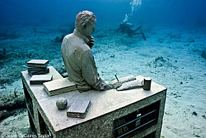
Artificial reefs are usually created by sinking a ship (after it has been thoroughly cleaned to prevent any toxic substances from entering the marine environment) or some other massive metal or concrete structure. Marine sediments gradually collect in, on, and around the objects, which are rapidly colonized by marine life. For rapid reef building, individual corals are sometimes transplanted onto the new structures.

The latest artificial reefs in Mexico are works of art. Jason deCaires Taylor, a British artist and dive instructor, has built an extraordinary collection of concrete sculptures and then carefully positioned them underwater in a marine park near Cancún, Mexico’s most popular tourist resort. The objective was to create an underwater “museum”, which divers and snorkelers can explore, while simultaneously providing a variety of structures for sea-life to inhabit.

Concrete sculpture, CancúnOne of the more remarkable sculptures is entitled “The Archive of Lost Dreams”. It features a librarian (pet dog at his feet) caring for and cataloging a collection of messages in bottles into “hopes”, “fears”, etc.. Another of the sculptures is a full-size model of the iconic Volkswagen Beetle.

The art-park, begun in 2009, is planned to house 400 sculptures in all and is billed as the largest underwater art museum in the world.

Another work now under construction is modeled on the ears of every child in a grade school class; it will be fitted with a hydrophone to enable marine biologists to analyze reef sounds (New Scientist, 17 December 2011).

Marine grade concrete is used for the exhibits, which are built to withstand a Category 4 hurricane. It is anticipated that hard and soft corals will eventually cover the sculptures, partially making up for the damage done to natural reefs by storms, tourists and boats, and reducing visitor pressure on the natural reefs. The natural reef off the coast of Quintana Roo, is part of the Mesoamerican Reef, the longest coral reef in the northern hemisphere and the second largest coral reef in the world. It is under constant pressure from coastal developments such as new hotels and cruise ship berths, as well as from climate change. The marine park near Cancún is visited by about 800,000 tourists a year.

The artist may think his idea is laudable, but not everyone is convinced. Critics argue that art works are not a good fit with the natural world, and why try to improve on nature? In addition, if artificial reefs are not carefully sited and well managed, they may be torn loose during storms and then cause extensive damage to any nearby natural reefs.

Related posts:

Feb 132012
 

No one doubts the need for reforestation in Mexico. Since colonial times, huge swatches of the country have been denuded of their native vegetation. Recent figures from INEGI suggest that Mexico has lost almost 50% of its native forests due to logging and clearance for farming and settlement. The majority of this loss is in the Volcanic Axis belt that stretches west-east across the center of Mexico at an average height of 3000 m above sea level, but tropical rainforest areas much further south have also been decimated.

There is, however, some encouraging news.

Data released by the UN Environment Programme (UNEP) puts Mexico in a lofty 4th place worldwide for the number of trees planted since UNEP began its “Billion Trees Campaign”  in 2007. According to the UNEP figures, only China, India and Ethiopia have planted more trees than Mexico.

The “Billion Trees Campaign, inspired by the work of the late Nobel Peace Prize Laureate Wangari Maathai, recognizes that trees bring multiple benefits to people, ranging from carbon sequestration and the provision of timber to soil erosion control, enhanced aesthetic value and opportunities for recreation. UNEP claims that 12 billion trees have been planted worldwide since the program began.

The short Youtube video – Taking Root The Vision of Wangari Maathai –”tells the dramatic story of Kenyan Nobel Peace Prize Laureate Wangari Maathai whose simple act of planting trees grew into a nationwide movement to safeguard the environment, protect human rights, and defend democracy—a movement for which this charismatic woman became an iconic inspiration.” (http://takingrootfilm.com)

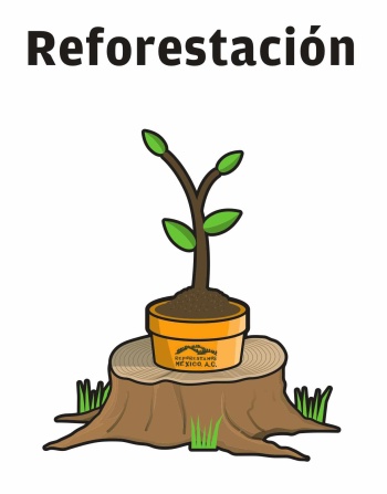
Poster prepared by Reforestamos México A.C.

Poster prepared by Reforestamos México A.C. (Mexican NGO) Visit www.reforestamosmexico.org for more information

But are the UNEP figures all they appear to be? Certainly, Mexico’s Environment Secretariat has organized, for many years, on-going programs of reforestation and conservation designed to stem the tide of logging that decimated Mexico’s natural forests over the past century. Official figures show that the pace of this effort has accelerated in the past few years. For example, between 2007 and 2011, Mexico’s National Forestry Commission protected, restored or reforested 21,000 square kilometers  (8100 sq. mi) across the country, an area equivalent to the state of Hidalgo. The total area reforested in those five years amounts to more than 3500 square kilometers  (1350 sq. mi).

On the other hand, critics of Mexico’s forestry policies, such as Greenpeace claim that up to 70% of all lumber sold in Mexico has been illegally harvested, and that less than 60% of trees planted in national campaigns survive their first few critical years.

Deforestation in the Monarch Butterfly Biosphere Reserve

One of the most critical areas, one where continued deforestation could be a real “game-changer”, is the Monarch Butterfly Biosphere Reserve which straddles the boundary between Michoacán and the state of Mexico. This is where millions of Monarch butterflies arrive each year from as far north as Canada to spend their winter. The butterfly itself is not endangered (there are non-migratory populations in many countries, and a year-round resident population in Mexico) but what assuredly is endangered is the “migratory phenomenon” of the Monarchs. Adequate forest cover at an altitude where winter weather is consistently within a narrow temperature band is absolutely crucial to the survival of this spectacular annual migration.

According to the National University (UNAM)’s Environmental Geography Research Center, at current rates of deforestation, the area of overwintering sites for the Monarch butterflies could be reduced by 75% in the next 18 years, leaving just 12,000 ha of suitable habitat. The protected area, established in 2000, covers 560 square kilometers (56,000 ha. or 216 sq. mi) but includes land cleared for pasture, settlement and cultivation. Researcher José López García claims the reserve is losing 3% of its forest each year. He blames clearance and changes of land use more than illegal logging. The rate of forest clearance has been exacerbated by a rapid rise in the population of the El Rosario ejido. El Rosario is the gateway to the most-visited part of the reserve, attracting thousands of tourists annually. The ejido’s population rose by an average of 5.65%/year between 2005 and 2010.

How will climate change affect Mexico’s forests?

Climate change is predicted to have several effects on Mexico’s forests. These include:

  • tropical rainforests (in both Mexico and Brazil) will gradually decline in extent, rainforest soils will have reduced fertility and some parts will become tropical grasslands.
  • the semi-arid areas in central and northern Mexico will become drier, and the total area of arid areas will increase

Globally, deforestation is believed to account for 17.4% of greenhouse gas emissions, so forest protection and reforestation are key strategies in efforts to mitigate the effects of further cliamte change.

The geography of wildfires in Mexico: the disastrous wildfire season of 2011

 Other  Comments Off on The geography of wildfires in Mexico: the disastrous wildfire season of 2011
Jan 212012
 

In the past 20 years, wildfires have destroyed 47,000 square kilometers (18,000 sq. mi) in Mexico, equivalent to five times the area of all sections of Mexico City’s Chapultepec Park, the largest urban park in Latin America. The average fire in Mexico affects 32 hectares (80 acres); this figure has not changed significantly in recent years, even though the incidence of fires has increased somewhat due to a combination of climate change and an increase in the number of people living on the margins of forested areas. The National Forestry Commission (Conafor) says that 99% of Mexico’s forest fires are caused by human error, and only 1% are due to natural causes such as lightning strikes.

It generally takes about 30 years to rehabilitate forest areas ravaged by fire, with reforestation costing up to $2400/ha.

Wildfires are not entirely bad. For example, they help regenerate grassland areas, especially, with fresh young plants. On the other hand, in addition to protecting the existing vegetation, stopping wildfires when they occur helps to preserve soil structure and prevents additional emissions of CO2 from the burning of more plant material. At a national level, it is estimated that fires result in the erosion of 86 million metric tons of soil a year.

In a 2009 study, Conafor used 17 variables to identify the areas of the county with the highest risk of wildfires. Three broad areas accounted for the 900,000 square kilometers identified as having either a “medium” or “high risk” for wildfires:

  • i. Yucatán Peninsula, Chiapas, Oaxaca and Guerrero
  • ii. Central Mexico – Veracruz, Tlaxcala, Puebla, México, Michoacán, Jalisco and the Federal District. This area has more fires than any other because local populations often use fire to clear fields before planting.
  • iii. Baja California. This is the only area where the main fire season is in summer, from March to November. This is the rainy season in the remainder of Mexico, where the fire season corresponds with the winter dry season.

The first half of 2011 was an especially bad period for wildfires in Mexico, the worst for at least 30 years.

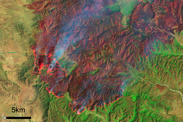
Coahuila wildfire, April 9, 2011 (Earth Observatory, Landsat-5)

Coahuila wildfire, April 9, 2011 (Earth Observatory, Landsat-5)

During the first half of 2011, serious wildfires devastated several areas of northern Mexico, with the states of Coahuila and Nuevo León being hardest hit. Other states badly affected included Durango, Chihuahua, Quintana Roo, Oaxaca, Puebla and Guerrero. More than 7,800 fires occurred, severely damaging a total area of 4100 square kilometers. 30 of Mexico’s 32 states were affected; only Tabasco and Baja California Sur escaped unscathed.

Conafor’s annual fire-fighting budget for the entire country is only 650 million pesos ($50 million dollars); the average annual area damaged by wildfires is only 2600 square kilometers, of which 500 square kilometers are forest. At the height of the 2011 fire season, more than 60 new fires were being reported each day, according to Conafor.

Coahuila

In the state of Coahuila, fires damaged 250 square kilometers in four weeks. It is believed that 50% of these fires were due to farmers losing control of deliberate burns. Farmers are supposed to have an adequate fire-suppression plan in place before setting a deliberate burn, but in practice this requirement is not enforced.

The main locations were La Sabina and El Bonito. Authorities were very slow to respond. Diana Doan-Crider, a wildlife biologist at Texas A&M University, has spent the past 25 years studying the Mexican black bear in the Serranía del Burro in Coahuila, an ecological corridor that runs parallel to the Eastern Sierra Madre. The area includes a large population of Mexican black bears. Doan-Crider claims that authorities completely ignored the first warnings and that their eventual response (two weeks after the first fires started) lacked adequate coordination. Many mother bears and their young cubs perished in the fires.

Firefighters in Coahuila had to cope with a spectacular but terrifying fire whorl or fire tornado

Nuevo León

In the neighboring state of Nuevo León, large swathes of ranching land were ravaged by fire. One rancher who lost more than 10,000 ha of cattleland was equally critical of the slow response time of firefighters who took more than two weeks to appear on the scene, by which time the fires had taken hold.

David Garza Lagüera had converted his 14,000 ha ranch into the Cumbres de Monterrey National Park, one of the key areas of bear habitat. The largest pines on his land were more than 150 years old. All were totally destroyed.

The worst damage was in Galeana, Montemorelos, Zaragoza, Aramberri and Mina. The area burned in Nuevo León in May 2011 was almost ten times the total area affected in the state for the whole of 2010.

Why was the 2011 fire season so bad?

To quote the Earth Observatory, “Lack of winter rain and frost left the plants dry and prone to fire. On top of that, the area has not burned for more than 20 years, during which time fuel built up. Thunderstorms and steady strong winds with gusts up to 110 km/h (70 mph) completed the formula for a dangerous, fast-moving wildfire.”

Ironically, the passage of Hurricane Alex in July 2010, which brought 1500 mm (60″) of rain to the Serranía del Burro, actually worsened the fire damage the following year. The rain from Hurricane Alex encouraged so much new growth in the final months of the rainy season that when it died back in the dry season, there was far more fuel available than usual for any wildfire that was sparked.

By the time the federal government declared a state of emergency, it was too late; the fires had already destroyed large areas of grassland, scrubland and forest. The emergency response when it finally arrived included help from the USA and Canada such as the specialist aerial Mars water-bombers stationed on Vancouver Island. The fires were only fully extinguished once the annual rainy season arrived.

As we now know, the disastrous fires of April-May 2011 were an early sign of Mexico’s worst drought for 70 years:

Mexico’s 2011 drought is raising the price of basic foodstuffs

 Mexico's geography in the Press  Comments Off on Mexico’s 2011 drought is raising the price of basic foodstuffs
Dec 052011
 

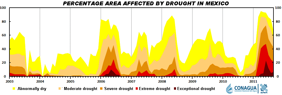
This year’s drought – see Many states in Mexico badly affected by drought is now widely viewed as the worst to occur since modern record-keeping for precipitation began about 80 years ago.

Short-term droughts are not unusual in Mexico. As the graph shows, there is a clear cyclical pattern to the timing of short-term droughts in Mexico. This is because most of the country receives almost all its annual precipitation in just a few months, from May or June (depending on precise location) to September-October.

The scale of the current drought is readily apparent from the graph. This year, far more of the country is affected, and the level of drought is far more severe.

Seasonal drought in Mexico, 2003-2012
Seasonal drought in Mexico, 2003-2012. Click to enlarge.

The drought is having numerous adverse impacts

It is already having an effect on food prices. Several of the basic foodstuffs  making up Mexico’s basic basket of goods for economic indices such as the inflation index, have risen sharply in price in recent months. A shortage of corn has led to a 70% increase in imports of yellow corn from the USA.

Incredibly, Mexico, the home of corn, is now the world’s second largest importer. Corn, as we have noted in previous posts, is a vital ingredient in Mexican cuisine, and is particularly important in the southern half of the country, especially in the more rural and indigenous areas. The shortage of corn has led to a rise in the price of tortillas, a dietary staple in almost all of the country. Tortilla prices have risen up to 18%, many times Mexico’s overall inflation rate of about 3.5%.

The production of chiles, another staple of the Mexican diet, has also fallen due to the drought, by an estimated 40%. In Zacatecas, that state’s 2,500 chile-growers will have produced 120,000 tons of green chile and 62,150 tons of dried chile this year, even though they have only been able to harvest chiles twice this year, rather than the normal four times. The state is the leading source of dried chile in Mexico. The area cultivated for chiles in Zacatecas has also fallen this year, to 31,300 hectares. The decrease in production has had a direct impact on the number of harvesting jobs available, since each hectare of chile cultivation usually means 150 seasonal jobs. The production shortage for chiles will be offset by more imports from Peru and China.

At latest count, 770 municipalities are now suffering from drought, and at least 2.5 million people in 1500 communities are left with insufficient drinking water. In the state of Durango alone, more than one million people are currently experiencing extreme drought, and 149 communities are completely without drinking water.

The long-term outlook is not favorable for these areas since climate change is expected to increase both the frequency and severity of droughts over the next twenty to thirty years.

Related posts:

The important but often overlooked state of Puebla

 Other  Comments Off on The important but often overlooked state of Puebla
Dec 022011
 

The interesting and important state of Puebla is often overlooked because it is overshadowed by nearby Mexico City. In fact the western state border of Puebla is within 35 kilometers of the eastern edge of the Federal District. The state of Puebla also may be overlooked because it is rather small in area, ranking only 21st among Mexico’s 32 states. On the other hand, its 2010 population of nearly 5.8 million ranks it 5th behind only Mexico State, the Mexico City Federal District, Veracruz and Jalisco.

Though small in size, Puebla is very diverse. The topography is rugged and elevations range from under 100 meters in the northeast to volcanoes  rising over 5,000 meters above sea level, both to the east (Orizaba – 5,636m) and west (Popocatepetl – 5,410m and Iztaccihuatl – 5,230m). These extremes in elevation give Puebla a very wide range of climates and ecosystems, from semi-tropical rainforests and grasslands to highland forests and alpine ice packs.

Almost inevitably, given its high population density (168.5 inhabitants/square kilometer), many of these ecosystems have been degraded. Several of the most attractive natural areas are now protected. They include the Izta-Popo Zoquiapán, La Malinche and Pico de Orizaba National Parks as well as the very large Tehuacán-Cuicatlán Biosphere Reserve, which has over 100 different mammal species, 16 of which exist nowhere else on the planet.

Puebla also has significant social and ethnic diversity. There are numerous wealthy people and upscale areas in Puebla City, which has the eighth highest 2005 Human Development Index (HDI) score among major Mexican cities, behind only Mexico City, Chihuahua City, Monterrey, Querétaro City, Cancún, Torreón and Cuernavaca. Most people are surprised it comes out ahead of Guadalajara and Zapopan.

On the other hand, the state as a whole is rather poor. Based on its relatively poor levels of infant mortality, literacy, school enrollment, and income levels, the state ranks 28th of 32 states in terms of 2008 Human Development Index. Puebla is tied with Michoacán and ahead of only Chiapas, Guerrero and Oaxaca[1]. It also ranks 28th in illiteracy which is over 10% (2010); however 96% of the 6 to 11-year-olds now attend school, and illiteracy for those between the ages of 15 and 25 is less than 3%. While 98% of homes now have electricity, over half of Puebla’s workers make less than $115 pesos ($8.20US) a day. Approximately two/thirds of the state’s population live below the Mexican poverty line. The state’s high level of poverty is partially due to its indigenous population of almost one million and the fact that almost 30% of its inhabitants live in rural areas, some of them quite remote.

The city of Puebla is the heart of a Metropolitan Area which extends across state lines to the city of Tlaxcala. Metropolitan Puebla-Tlaxcala is the country’s 4th largest urban area with a population over 3.1 million, but is overshadowed by Mexico City, the eastern edge of which is less than 30 minutes by expressway. In fact, some urban specialists suggest that these two major metropolitan areas may merge in the future. On the other hand, the mighty Popocatepetl and Iztaccihuatl volcanoes, both over 5,000 meters in height, lie directly between the two cities. The high speed expressway skirts around the north side of the volcanoes.

The city of Puebla has long had strategic significance. The city was initially established during the colonial period owing to its strategic location between Mexico City and Veracruz, the dominant port for shipments to and from Spain. Puebla was the country’s second largest city for more than three centuries up until the mid 19th century. The Mexico City-Puebla railway was completed in 1869, but the main line to Veracruz bypassed the city, which diminished its comparative advantage, and resulted in it dropping to fourth place, overtaken by Guadalajara and Monterrey.

The state’s historical importance is evidenced by numerous important military confrontations, including the massacre of Cholula (1519), Santa Ana’s siege of Puebla City (1845), American General Winfield Scott’s occupation (1845-48), the “Cinco de Mayo” battle of Puebla against the French (1862), the French victory in the Second Battle of Puebla (1863), and occupation by the Zapatistas during the Mexican Revolution. The state is the birthplace of four Mexican Presidents: Ignacio Comonfort (1855–1858), Juan N. Méndez (1876–1877), Manuel Ávila Camacho (1940–1946) and Gustavo Díaz Ordaz (1964–1970).

Despite the state’s relative poverty, industrial development has been significant and Puebla has become one of Mexico’s most industrialized states. Since colonial times Puebla has been an important center for the textile and ceramic industries. Much of Mexico’s famous talavera pottery is made in Puebla. Talavera came to Puebla from Talavera, Spain, which in turn had acquired it from Arab traders who originally brought it from China.

Since the mid 20th century Puebla has become a very important modern industrial area. The most important manufacturing activities are metals, chemicals, electronics, textiles and particularly motor vehicles. The Volkswagen plant in Puebla is one of the largest outside Germany. In July 2003 it produced the very last of the over 21 million old “Beetles” built by VW. The plant now produces New Beetles, Jettas and Boras that are exported worldwide. The motor vehicle assembly industry is supported by scores of automobile parts factories in the state.

Related articles:

Mexican migrants and remittances: an introduction

 Books and resources, Index page  Comments Off on Mexican migrants and remittances: an introduction
Nov 072011
 

Remittances (the funds sent by migrant workers back to their families) are a major international financial flow into Mexico. Remittances bring more than 20 billion dollars a year into the economy, an amount equivalent to 2.5% of Mexico’s GDP.

On a per person basis, Mexico receives more worker remittances than any other major country in the world. An estimated 20% of Mexican residents regularly receive some financial support from relatives working abroad. Such remittances are the mainstay of the economies of many Mexican families, especially in rural areas of Durango, Zacatecas, Guanajuato, Jalisco and Michoacán.

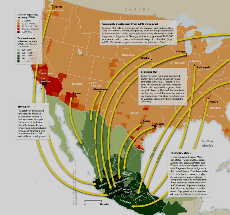
The map below accompanied a 2007 Atlantic Magazine report by Matthew Quirk entitled “The Mexican Connection: mass migration has left many towns in Mexico half-empty, but much wealthier.” The map is based in part on work by Raúl Hernández-Coss for the World Bank. The map and article provide an excellent starting-point for considering the basic patterns and impacts associated with remittance flows between the USA and Mexico. The article is an easy-to-read introduction to many of the key issues connected to remittances.

The data used for the map come from the US Census and from the registration records held by Mexican consulates in the USA.

Summary of migration flows between Mexico and USA

Summary of migration flows between Mexico and USA; click to enlarge Source: Atlantic Magazine.

The causes and consequences of mass out-migration and large remittance payments are varied, and sometimes disputed. For background, causes and trends, try:

For some impacts of Mexican migrants on the USA (of varying importance), see:

The four subtitles used in the Atlantic Magazine article are useful reminders of some of the other major aspects of international migration from Mexico. Again, links are given to previous Geo-Mexico posts which look at good examples.

“Branching Out” emphasizes the links that exist between communities, often referred to as “migration channels”.

“The Hollow States” identifies the five major “states of origin”—Guanajuato, Jalisco, Michoacán, San Luis Potosí and Zacatecas—which receive almost 50% of all remittance payments.

“Staying Put” points out that improved economic conditions in Mexico in recent decades, have restricted out-migration from certain areas, especially the border region. Recent developments in Mexico’s war on drugs have, however, led to an increase in the number of border residents moving to bigger, safer cities further south, or seeking to emigrate to the USA.

“Community Development” stresses the important link between “hometown associations” (groupings, found in many US cities, of Mexican migrants sharing a common area of origin) and their related villages and towns in Mexico. Many community development projects in areas of high out-migration have been financed by remittances. In many cases, the three levels of Mexican government—municipal, state and federal—provide matching funds for such projects, meaning that remittances only pay for 25% of the total costs.

In future posts, we will examine some of these aspects of remittances in more detail, and take a much closer look at the precise mechanisms used to make the international financial transfers involved.

Mexico Pan-American Highway, route of one of the toughest road races in the world

 Other  Comments Off on Mexico Pan-American Highway, route of one of the toughest road races in the world
Nov 022011
 

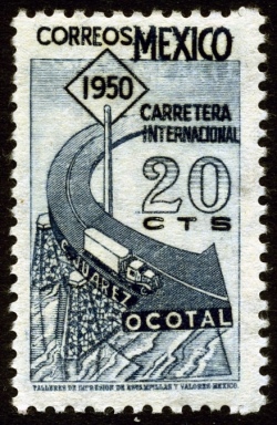
The completion of the Mexican stretch of the Pan-American Highway, from the US border to Guatemala, in the late 1940s was a significant turning-point in the development of Mexico’s road network. The highway made previously remote areas more accessible, but, far more than that, it served as a symbol of unity and Mexico’s progress into the modern era. Only a few years later, the total length of federal highways exceeded the total combined length of the country’s railway lines. As highway transport of freight and passengers took over, rail transport never fully recovered.

To celebrate the opening of the Pan-American Highway, in 1950 a major road race was organized: the Pan-American Race (Carrera Panamericana). The race was held annually until 1954, after which authorities claimed that it had achieved the desired publicity. Actually, the race had achieved considerable undesired publicity as one of the world’s most dangerous road races, 27 people having lost their lives in five years the race was held.

The race was revived, but as a modern, shorter version arranged as a stage rally for vintage cars, in 1988. The 2011 race has just finished.

7 days, 100 cars, 3,000 km, one crazy race (Globe and Mail)

Racers in the early 1950s achieved some astounding average speeds, up to 135 mph for an entire stage. The following extract from a contemporary news report tells the story:

“The 3114 km Mexican road that stretches south to north from Tuxla to Juárez is, according to Alfred Neubauer [a legendary Mercedes-Benz Competition director], a combination of Tripoli’s Grand Prix, the Italian Mille Miglia, the German Nurburgring, and the Le Mans 24 hrs….

The race begins in a tropical climate where the temperature is high and humid and continues along a road that goes from sea level to a suffocating 3000 meter altitude! Temperature variations go from 34 Celcius to almost 2 degrees above freezing in just 72 hours… Carburetors and spark plug selection need alterations every 160 km approximately. Motors that ran miraculously at 1000 mts sounded almost dead at 3000….

The road is paved with a mixture of volcanic ash and this highly abrasive substance will turn a perfectly new passenger car tire to a worn-out one in a 1000 km distance.”

The current road network in Mexico is extensive, covering virtually all areas of the country. Mexico has over 120,000 km of paved roads, far more than any other country in Latin America. By contrast, Brazil has about 96,000 km. There are over 10,000 km of controlled access toll expressways (even if they are among the most expensive in the world!). There are an additional 10,000 km of free four lane highways. Mexico also has over 200,000 km of unpaved roads.

Want to read more?

Veracruz: one of Mexico’s most diverse states

 Other  Comments Off on Veracruz: one of Mexico’s most diverse states
Oct 242011
 

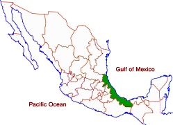
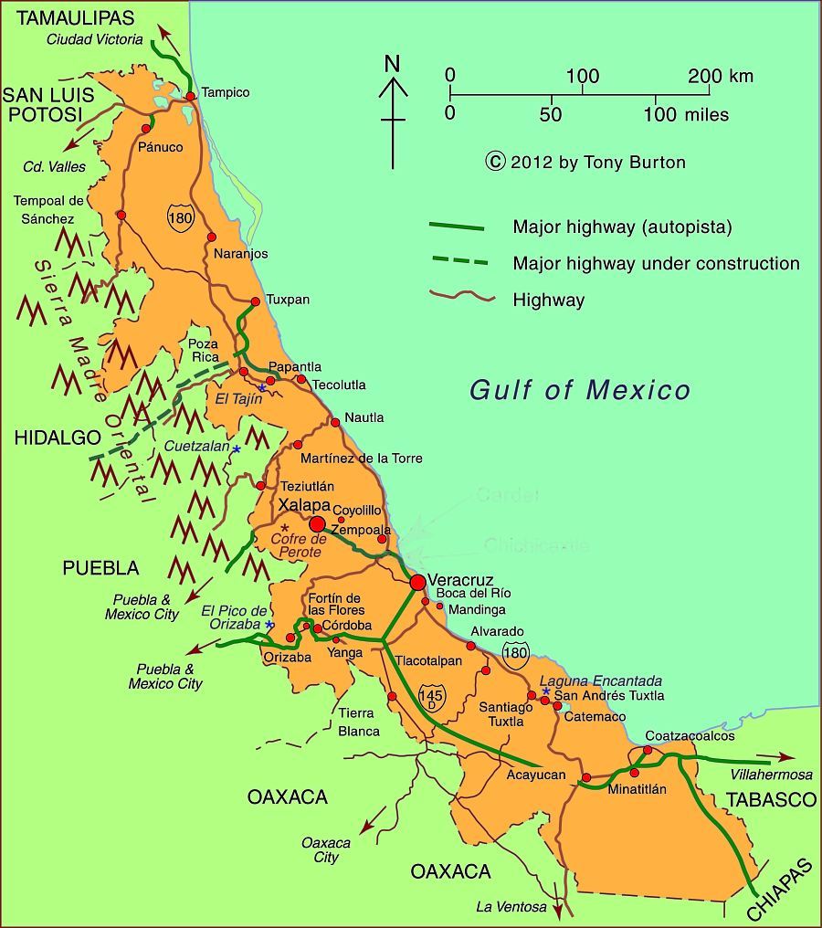
Veracruz, one of Mexico’s most important and interesting states, is a narrow strip of land stretching for 650 kilometers (over 400 miles) along the Gulf of Mexico. The topography ranges from a narrow coastal plain to very high mountains on its western border including Mt. Orizaba, Mexico’s highest peak at 5,610 meters (18,406 ft.).

The relief helps to funnel migrating birds into a narrow band across the state:

Veracruz which is one of the rainiest states has three of Mexico’s five largest rivers: the Panuco in the north and the Papaloapan and Coatzacoalcos rivers in the south. Its varied climate and ecosystems mean enormous biodiversity, including species of insects, birds and plants that exist nowhere else on earth. These species are protected in 31 protected areas including three national parks. Previous posts describe the fabulously beautiful Las Tuxtlas Biosphere Reserve and the mysterious Laguna Encantada.

With over 7.6 million residents, Veracruz trails only the State of Mexico and the Federal District in population. While the state is over one-third rural, it has several major metropolitan areas. The state capital is Xalapa (809,000). Other major cities include the industrial twin cities of Coatzacoalcos (234,000) and Minatitlán (356,000) in the extreme south, and the port city of Veracruz (703,000) in the center. The north of the state is served by the port city of Tampico (803,000) on the north bank of the Panuco River in the neighboring state of Tamaulipas.

One of the most interesting towns is Yanga, which was established around 1570 by escaped slaves lead by Gaspar Yanga. The town, the first African-ruled settlement in the New World, successfully resisted efforts by the colonial government to recapture it and its residents. Today, Gaspar Yanga is considered a national hero. It is interesting to note that Negroid features are apparent on the ancient 3,500 year old Olmec carved stone heads found in southern Veracruz. The state is home to numerous indigenous groups including the Nahuas, Huastecos, Otomis, Totonacs.

Map of Veracruz state, Mexico; all rights reserved.

Map of Veracruz state, Mexico; all rights reserved. Click to enlarge.

There are two UNESCO-designated World Heritage sites in Veracruz: the Pre-Hispanic city of El Tajin and the Historic Monuments of the Zone of Tlacotalpan.

Veracruz is one of Mexico’s poorer states. Mostly as a result of its very large rural, agricultural and indigenous populations, Veracruz ranks in the bottom third in most socioeconomic indicators such as production/person, percent living below the poverty level, human development index, literacy, infant mortality, life expectancy and marginalization. On the other hand, these indicators for the major cities are above the national averages.

Veracruz is second in total agricultural production behind only Jalisco. It produces more than half of the country’s sugar cane and oranges and also leads in mangoes and other citrus fruits. It is also a major producer of coffee, beef, pork, dairy, chicken, corn, beans, bananas, tobacco, coconuts, vegetables and vanilla.

Petroleum is extremely important. Most of the oil production is in northern Veracruz while the southern cities of Coatzacoalcos and Minatitlán are noted for their chemical and petrochemical industries.

Veracruz is also famous historically and culturally. Cortés and his men landed in Veracruz on their way to conquering and subduing all of Mexico. Veracruz city was the most important port for many centuries when it served as Mexico’s main link to the rest of the world. The state capital was eventually moved to Xalapa, which has a flourishing cultural life and an anthropology museum second only to the National Anthropology Museum in Mexico City. The annual Carnival staged in Veracruz is one of the most spectacular in all of Mexico. The Danza de los Voladores (Dance of the Flyers) in Papantla is a major tourist attraction for Mexicans and foreigners alike. Veracruz also has its own distinctive music and cuisine, enhancing its regional identity.

The diffusion of the Africanized honey bee in North America: a bio-geographical case study

 Other  Comments Off on The diffusion of the Africanized honey bee in North America: a bio-geographical case study
Oct 082011
 

Africanized honey bees, sometimes popularly called “killer” bees, resulted from the crossing (hybridization) of European honey bees and African honey bees. They combine the best and the worst of both sets of relatives. Africanized honey bees are slightly smaller than European honey bees, but more aggressive and less inclined to remain in one place. They can swarm and attack even if unprovoked, even though they can sting only once before dying shortly afterward.

Their “killer bee” label is because they have killed 1,000 people in the Americas since their ancestors escaped from a laboratory in Brazil. Africanized bees react ten times faster to disturbances than European bees and can pursue a hapless human victim for 300-400 meters.

The mixing of genes that created Africanized honey bees occurred in the 1950s. In 1956, Dr. Warwick Kerr, a bee researcher in Brazil, hoped to develop a bee that would thrive in Brazil’s tropical climate. He decided to cross European bees with African bees. Unfortunately, in March of the following year, some of his experimental bees escaped into the wild. The Africanized bees soon began to multiply and expand their range. They proved to be very adaptable, and have since spread, at a rate of up to 350 km/year through most of South and Central America, as well as into Mexico and the USA. They arrived in Peru by 1985 and Panama by 1982. Their spread northwards continued, and they crossed from Guatemala into Mexico, near Tapachula, in October 1986.

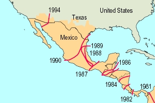
The map shows the gradual northward spread of Africanized bees in Mexico. Up to 1987, the progression looks fairly regular, but in the following year, Africanized bees’ northward movement was restricted to a zone along Mexico’s Gulf Coast. This remained true even through 1989. By 1990, the “front” of the bees advance once again stretched right across the country.

Q. What factors may have caused the unusual (anomalous) geographic spread of Africanized bees in 1988 and 1989?

Map of africanized bees spread across Mexico

Africanized bees spread across Mexico (adapted from Kunzmann et al)

Why are Africanized bees more migratory than European bees?

Scientists believe that Africanized bees are uniquely equipped to cope with the unpredictability of suitable food sources in the tropics. They are more opportunistic, changing their foraging habits to suit local conditions, including short-term supplies of pollen, which they will collect and store to ensure their survival. When a new resource presents itself, Africanized bees will swarm rapidly to maximize their use of the new pollen source.

In bio-geographical terms, Africanized bees are an example of an opportunistic or r-species, perfectly equipped to move to new or changing habitats. They reproduce rapidly, and use available resources efficiently. This makes them far less stable than European bees which thrive in a more predictable environment and adapt to changing circumstances far less quickly.

Africanized bees can survive on limited food supplies, will explore and move to new locations frequently and are aggressive in defending their resources. When they come into contact with other less aggressive bees, such as Mexico’s native bees, Africanized bees may out-compete them for pollen and eventually replace them as that area’s dominant bees.

In Mexico, the speed of diffusion of Africanized bees slowed down

When Africanized bees were reported from southern Mexico, US beekeepers began to fret. The US honey industry is worth 150 million dollars a year. Fear spread that Africanized bees might jeopardize the entire industry, mainly because they are prone to migrate, and would be hard to control.

US experts helped finance a joint program in Mexico which aimed to slow down the bees’ progress northwards. The original idea was to stop bees from crossing the narrowest part of Mexico, the Isthmus of Tehuantepec, preventing them from reaching central Mexico. However, by the time funding was approved, some bees had already crossed the Isthmus. The focus of the bee-control plan was changed to trying to slow down their seemingly inexorable progress north. Even if scientists could only delay the bees’ progress, it would give US farmers more time to plan for their eventual arrival.

The plan was relatively simple. Hang sufficient bee traps in trees throughout the region to attract wild swarms while banning Mexican beekeepers from moving any hives from southern Mexico into central or northern Mexico. Thousands of distinctive blue boxes appeared in orchards and forests across a broad belt of Mexico, from the Pacific to the Gulf.

The combined Mexico-US program is credited with having slowed the bees’ entry into the USA down by about two years. Even so, by 1990, Africanized bees were spotted in Texas; they reached Arizona by 1993 and California by 1995. By this time, they were also found throughout Mexico.

In a later post, we will look at honey production in Mexico and see whether or not it was permanently affected by the influx of Africanized bees.

Sources:

(a) “Africanized Bees in North America” by Michael R. Kunzmann et al, in Non-native Species by Hiram W. Li (biology.usgs.gov)

(b) Introduced Species Summary Project: Africanized Honey Bee by Christina Ojar, 2002.

(c) Alejandro Martínez Velasco. Las andanzas de la Abeja Africana Informador (Guadalajara daily), 1 September 1991.

Review of “Mexican National Identity, Memory, Innuendo and Popular Culture”, by William H. Beezley

 Books and resources  Comments Off on Review of “Mexican National Identity, Memory, Innuendo and Popular Culture”, by William H. Beezley
Sep 152011
 

William H. Beezley, a professor of history at the University of Arizona, has written widely about Mexican history. He was co-editor, alongside Michael C. Meyer, of the Oxford History of Mexico, an illustrated “narrative chronicle” through the centuries, and a landmark modern history of Mexico. In this book, first published in 2008, Beezley explores the development of Mexican National Identity through a history of some facets of its popular culture.

As in the case of his earlier work (Judas at the Jockey Club and Other Episodes of Porfirian Mexico), Beezley’s Mexican National Identity. Memory, innuendo and popular culture (University of Arizona Press), is wide-ranging and engaging. The book consists of five essays on different themes which Beezley considers central to the development of Mexican National Identity.

In the first chapter, Beezley looks at how the character known as El Negrito came to be “one of the most famous marionettes of nineteenth-century puppet theater”. El Negrito, an Afro-American usually portrayed as a Veracruz cowboy, personified the attitudes of nationalistic Mexicans in the nineteenth century, with his mocking of the French and Maximilian, his temper tantrums, his infidelity, his wit and his resistance to the American invaders.

beezley - coverFrom a geographic perspective, chapter two is the book’s most interesting. The chapter opens by looking at the development of maps which “like symbolic physical features and regional individuals, portrayed Mexico with diversity as the salient attitude”. He describes two 18th century maps, drawn specifically for clerical travelers, highlighting altitude (and therefore climate) and language (ethnicity), but lacking scales, physical features or other landmarks. The modern era of Mexican map-making began with Alexander von Humboldt, and was extended later in the 19th century by others including Antonio García Cubas.

The production of maps necessarily included decisions as to which landmarks, places and features were most important. It also prompted clearer definitions of national boundaries, in both the north and south. In Beezley’s words, “This question of borders had political significance, and both cultural and social dimensions as Mexicans believed the boundaries divided their civilized society from the barbarians beyond.”

Chapter 2 then examines the role of almanacs and lotería (lottery cards), the quintessential Mexican parlor game, in helping to foment national attitudes. Almanacs were “a source of popular or local history and collective memory”. They gave potted summaries of the lives of the saints and martyrs, lists of holy days, images and biographies of political leaders and so on.

Lottery cards shared stereotypical views of objects and characters, often related to local stories. Beezley says that the version played in Campeche eventually gained the greatest popularity. The images used in Campeche formed the basis for the earliest commercially produced sets of cards when Clemente Jacques (a French immigrant and founder of the eponymous food processing brand)  first launched his range of culinary products, from chiles, olive oil and mole sauce to beans, jams and honey, and founded his own printing business to print his own labels. Jacques promoted his brand at the world’s fairs in Chicago (1893) and St. Louis (1904), using printed decks of lotería cards as a form of advertising. His cards became the basis for the modern packs of lotería cards sold throughout Mexico. Many of the most common images have multiple associations, some even including an overtly sexual double meaning. Some figures such as El Borracho (The Drunk) and El Valiente (The Brave One) and La Sirena (The Siren/adultery) are not associated with a particular region or place. Others such as The Scorpion and The Toad are readily associated with specific geographic regions or states: Durango and Guanajuato respectively. Almanacs and lotería cards helped reinforce a sense of national identity while recognizing regional and ethnic differences.

In Chapter 3, Beezley focuses on how celebrations of Mexican Independence gradually came to assume a massive significance for national identity. Independence came in 1821, but it was not until 1869 that annual celebrations of Independence Day really took off. On September 16, 1869, the Mexico City-Puebla railway line was inaugurated, beginning an exciting new era for transportation, which was to have far-reaching effects. During the presidency of Porfirio Díaz, Mexico celebrated its centenary of Independence, an event marked with banquets, parades and the opening to the public of a hastily-restored section of “The Pyramids” at the archaeological site of Teotihuacan. Beezley outlines how the popular perception of Mexico’s patron saint, the Virgin of Guadalupe, changed in less than a century from “the terrifying emblem of Padre Miguel Hidalgo’s insurrection, and the patron of downtrodden, rebellious Mexicans, to the patron saint of the dictatorship’s elite.”

Chapter 4 looks at the role of itinerant puppet theater in molding Mexico’s national identity. The largest and most famous single troupe was the Rosete Aranda troupe, formed by two Italian immigrants in 1850. The troupes went from strength to strength in the next half-century. By 1880, the Rosete Aranda company had 1,300 marionettes and by 1900 a staggering 5,104. Their creativity knew few bounds, and by undertaking annual tours around the country, they helped influence opinions and attitudes. Incidentally, their need to undertake annual tours was in keeping with the established principles of central place theory. As described in Geo-Mexico, the same principles apply in the case of traveling circuses.

In the hierarchy of central places, each step up sees a smaller number of places, each providing a wider range of goods and services, and serving a larger market area. This occurs because for a service to be provided efficiently there must be sufficient threshold demand in the central place and its surrounding hinterland to support it. For this reason we do not find new car dealers, heart surgeons or ballet schools in every small village. These activities can only survive in much larger centers where there is sufficient demand. Individual residents are not prepared to travel far in order to access a service of relatively low value. This poses a challenge for services such as puppet shows which are unable to command a high ticket price, but which need large numbers of potential viewers (a large threshold population) if they are to succeed. This quandary can be resolved by moving from one mid-sized center to another throughout the year, gaining access to a new audience in every location.

Needless to say, the invention of modern communications systems such as television means that this is no longer entirely true, except for live performances.

Beezley’s entertaining romp through Mexican popular culture and its links to national identity is well worth reading. It may not discuss all aspects of how Mexico’s national identity developed during the 19th century, but it provides numerous valuable insights into how a country of such diversity gradually acquired a clearer sense of national identity and purpose.

Where to buy:

Mexican National Identity. Memory, innuendo and popular culture, by William H. Beezley (link is to Sombrero Books’ amazon.com page).

Mexico’s Fair Trade coffee faces an uncertain future

 Updates to Geo-Mexico  Comments Off on Mexico’s Fair Trade coffee faces an uncertain future
Aug 302011
 

An earlier post looked at why Mexico’s coffee harvest was unlikely to meet expectations this year. The 2010-11 harvest, hit by poor weather, totaled a disappointing 4 million 60-kg sacks (240,000 metric tons), almost entirely Coffea arabica and about 70% destined for export. This post looks at some recent trends relating to the production and consumption of coffee in Mexico.

Mexico is the world’s seventh largest coffee producer (after Brazil, Vietnam, Indonesia, Colombia, India and Ethiopia) and one of the leading suppliers of organic, shade-grown coffee. The nation’s 480,000 coffee growers, most working small parcels of land less than 5 hectares (12 acres) in size, are concentrated in the states of Chiapas, Veracruz and Oaxaca.

Mexico’s domestic consumption of coffee

Despite being one of the world’s leading coffee producers,Mexico’s domestic consumption averages only 1.2 kg (2.6 lbs) per person each year. While this figure has doubled since 2000, is is still only about half the equivalent figure for the coffee-growing Central American nations, and way below consumption in wealthier countries such as world-leader Finland (12 kg per person) or the USA (5.5 kg per person). Domestic consumption is rising but remains low.

Yields need to rise

According to Amecafe (Asociación Mexicana de la Cadena Productiva del Café), a major growers’ organization, global climate change is expected to have an adverse long-term effect on prices and on the sustainability of coffee-farming in Mexico. In an effort to raise yields of coffee to at least 12 quintals/hectare (19 bushels/acre) within 3 years and to 20 quintals/ha (32 bushels/acre) eventually, Mexico’s Agriculture Secretariat has announced financing of 16 million dollars for a program to gradually replace aging coffee groves in 12 states.

Fair trade coffee faces uncertain future

Soaring coffee prices might signal the beginning of the end for Fair Trade coffee. Much of the world’s specialty coffee comes from small-scale growers in Latin America, including Mexico, and much of it is marketed as “organic” or “fair trade”. After a decade of depressed prices, wholesale and retail prices for coffee have risen sharply in the past year. US retail prices have risen more than 20%; the price of coffee on international commodity markets has risen almost 60%.

The higher prices should be good news for growers, but as Kevin Hall points out in “Coffee prices being pushed by speculators” this is not necessarily the case. Many co-operative marketing organizations, including those considered socially-responsible or “Fair Trade”, do not have the resources to pay the new higher prices and acquire sufficient coffee to meet their existing contracts. This means they can no longer compete against the well-financed middlemen who specialize in purchasing coffee for regular distribution via commodities markets and major buyers. Farmers want the maximum return they can get on their crop, and they want it on delivery, which makes life difficult for any fair trade co-operative that lacks strong financial resources.

Further statistics:

  • USDA (US Department of Agriculture) June 2011 update on coffee (pdf file).

Related post:

Aug 222011
 

The proposed implementation of a United Nations-supported carbon storage program (REDD) in the southern Mexican state of Chiapas is provoking plenty of controversy. The debate is hotting up because a follow-up program called REDD+ is due to start in 2012. A good summary of the situation is provided by REDD rag to indigenous forest dwellers.

What is REDD?

  • REDD stands for Reducing Emissions from Deforestation and Forest Degradation
  • It is a carbon storage program, started in 2008 by the Food and Agriculture Organization (FAO), the U.N. Development Programme (UNDP) and the U.N. Environment Programme (UNEP).
  • It aims to conserve biodiversity and boost carbon storage by preventing deforestation and by replanting forests
  • It is focused on developing countries, and provides them wih funds and technical support

At first glance, it would seem like a good fit for Chiapas, one of Mexico’s poorest states, where a high proportion of the population are reliant on subsistence farming. The Chiapas state government backs REDD, considering it as one way of helping mitigate the likely consequences of climate change in the state. Chiapas’ total emissions of carbon dioxide amount to 32 million metric tons/year, about 4.5% of the national figure. The Chiapas contribution comes mainly from deforestation and farming.

NGOs working in Chiapas warn that REDD poses a serious threat to indigenous people. About 20% of the 4.8 million people living in Chiapas belong to one or other of the state’s numerous indigenous groups. Land tenure in many parts of Chiapas is hotly disputed; this was one of the reasons for the EZLN (Zapatista Army of National Liberation) uprising in 1994.

Protests in support of indigenous rights, Cancún climate summit

Protests in support of indigenous rights, Cancún climate summit, 2010

Miguel García, a spokesperson for an NGO founded in 1991 which supports indigenous groups and protects the environment, has been quoted as saying that REDD “will alter indigenous culture, will commodify it, giving commercial value to common assets like oxygen, water and biodiversity.” He is especially concerned that “resentment of and confrontation with the Zapatista grassroots supporters are being accentuated.”

As with so many geographic issues, there is no easy “right answer” here. The rights of indigenous groups need to be respected and their views taken into account, before any decision is made about the value of their forest home to global efforts to mitigate climate change.

This is one controversy we plan to follow as it plays out in coming months.

Want to read more?

Related posts:

The troubled rise of the Green Movement in Mexico

 Other  Comments Off on The troubled rise of the Green Movement in Mexico
Aug 012011
 

Two specific events helped stimulate the rapid growth of Mexico’s green movement in the 1980s:

These motivated many citizens to take direct action. Membership in Environmental Non-Governmental Organizations (ENGOs) surged, as “green brigades” aided the victims. Two months after the earthquake, representatives from 300 regional groups met and formed a coalition of green groups focused on issues such as deforestation, pollution, and opposition to nuclear power. The 1992 Rio UN Environmental Summit and opposition to NAFTA (because it neglected environmental issues) provided additional stimulus to the movement.

The number of ENGOs increased from fewer than 30 in 1985 to about 500 by 1997 when about one in twenty Mexicans was a member of an ENGO.  The ENGOs had highly professional staffs and were well funded from Mexican and international sources. Through demonstrations and militant actions they successfully stopped the construction of a half billion dollar tourism complex south of Mexico City and the proposed world’s largest salt mine in Baja California. They also were significant in the passage of new laws for environmental protection, reducing deforestation, protecting wildlife, and establishing protected areas.

Vicente Fox, the PAN/Green Party candidate, won the Presidency in 2000.  His Minister of the Environment, Víctor Lichtinger, brought scores of highly qualified fellow key ENGO leaders into the administration. While this put the nation’s leading environmentalists on the inside, it also essentially “decapitated” and deflated the ENGO movement, especially its more militant members. Despite these key appointments, Fox’s administration gave relatively low priority to environmental issues. When Fox sided with tourism investors, and decided against issuing a detailed analytical report on beach pollution, Lichtinger and many of his senior staff resigned. They mostly moved to international or academic positions and consequently did not rejuvenate the leadership of the ENGOs they had left.

Green party logo

Green party logo

For the 2006 election, the Green Party formed an alliance with PRI and came in a weak third. The party, which has suffered from despotism, bribery and violation of election laws, managed to elect 22 diputados in the 2009 election. The Calderón Presidency has obtained good environmental marks for its leadership in global warming; however its comprehensive tree-planting program has received some criticism. Current ENGO activity is focused less on high profile mass mobilizations and protests, and more on specific issues such as legislative  lobbying, public awareness, climate change, energy issues, water, deforestation, biodiversity, recycling and local tree=planting and clean-up campaigns.

Main source: Jordi Díez, “The Rise and Fall of Mexico’s Green Movement”, European Review of Latin American and Caribbean Studies 85, October 2008, 81-99.

Mexico’s environmental issues are analyzed in many chapters of Geo-Mexico: the geography and dynamics of modern Mexico, including chapter 30. Explore the book using Amazon.com’s Look Inside feature and buy your copy today!

How will reduced out-migration impact Mexico’s total population?

 Updates to Geo-Mexico  Comments Off on How will reduced out-migration impact Mexico’s total population?
Jul 192011
 

As described in an earlier post –Is massive Mexican migration to the USA a thing of the past?– we examined a 6 July 2011 New York Times article which indicated that Mexican migration to the USA had slowed to barely a trickle. If this is correct, Mexico’s population will be considerably higher in future years. This post estimates what this impact will be.

In another post –Projecting Mexico’s population: when, if ever, will it stop growing? – we incorporated the results of Mexico’s 2010 census and 2008 migration estimates into the most recent official population projection available from the Mexican Government’s CONAPO (Spanish acronym for National Population Commission). This analysis indicated that Mexico’s population would peak at 140.5 million in 2043, rather than the 130.3 million indicated in the older CONAPO projection.

If net migration becomes zero in the future, as suggested in the New York Times article, Mexico’s population will peak at 149.3 million in 2051. If net migration in future years is between the 2008 estimate of 203,000/year and zero, say 100,000/year, then the Mexican population will peak at 144.9 million in 2049. Clearly, the variation in these projections of almost nine million (149.3 verses 140.5) is quite significant. Given these different projections, our current thinking is that Mexico’s population will probably peak at around 145 million about mid-century.

Though population projections based on birth and deaths rates tend to be fairly accurate, net migration projections are far more precarious. Actual net migration between the two countries will depend on a wide range of future socio-economic variables for both countries. The most obvious of these variables will be fertility rates, growth of the working age population, education opportunities, economic growth, trade regulations and trends, job availability, unemployment rates, and personal preferences of both workers and retired people. There undoubtedly will be surprises such as technology changes or climate change. Some of these may have very profound impacts on migration, and therefore on total population levels.

Migration between Mexico and the USA is the focus of chapters 26 and 27 of Geo-Mexico: the geography and dynamics of modern Mexico. Explore the book using Amazon.com’s Look Inside feature; buy your copy today!

Are Mexico’s rural areas more diverse than its cities?

 Excerpts from Geo-Mexico  Comments Off on Are Mexico’s rural areas more diverse than its cities?
Jun 302011
 

Which are more diverse: Mexico’s rural areas, or its cities?

At first glance, Mexico’s rural areas are all quite similar in that they lack the characteristics of Mexico’s large cities such as tall buildings, traffic congestion, modern shopping malls, bustling streets, heavy industry and the like. While rural areas are all similar in that they lack urban characteristics, Mexico’s rural areas are actually quite diverse. But is there really more diversity among Mexico’s rural communities than its cities?

The physical form and architecture of cities are essentially independent from their surrounding natural environments. On the other hand, rural settlements tend to be integrated more closely with the natural environment. For example, villages in the arid central plateau tend to be constructed of locally available adobe, which keeps residents relatively cool during the hot afternoons and warm during the colder nights. In the tropical parts of Mexico, rural settlements tend to be built with locally available tropical materials which keep the rain out, but let air breezes through to mediate the hot tropical climate.

Rural settlements all tend to rely heavily on farming as the basic economic activity. The surrounding natural environment essentially dictates the type of farming that is practiced. Obviously, farmers in the central plateau cannot successfully grow bananas, sugarcane and other tropical products requiring lots of water. However, varieties of corn are grown virtually everywhere in Mexico.

The social characteristics of Mexico’s rural areas are also very diverse compared to the cities. In general Mexican cities are quite similar from a social perspective. Social customs and mores, as well as social classes, are relatively constant from one city to the next. Spanish is the overwhelmingly dominant language in the cities. Rural communities in various parts of the country often have different social mores and customs. Communication in some rural areas is largely, if not almost exclusively, in local indigenous languages:

The diversity of Mexico’s almost 200,000 rural localities should not be confused with the relative homogeneity within any given rural community.

In conclusion, while diversity between rural areas may be greater than that between cities, there is usually far more diversity within a Mexican city than within any given rural community.

How did Mexico get to be the world’s 11th most populous country?

 Other  Comments Off on How did Mexico get to be the world’s 11th most populous country?
Jun 112011
 

Mexico is currently the world’s 11th most populous country. While it has not always held this position, Mexico has been among the world’s population leaders for the last two thousand years. Worldmapper.org provides data on the estimated population occupying the areas of current countries for various years starting in the year one, when India (62 million) and China (60 million) had more than half of world’s total population of 231 million. No other country had more than eight million. Mexico ranked 17th with an estimated two million inhabitants. According to available data eight countries have always been more populous than Mexico: China, India, Bangladesh, Russia, Pakistan, Japan and Indonesia.

The next data point is the year 1500, when Mexico ranked 13th with an estimated population of seven million. This estimate seems reasonable, though some feel that Mexico’s population might have been as large as 15 million which would have made Mexico the third most populous country on the planet behind only China and India. Between year 1 and 1500, Mexico surpassed Turkey, Spain, Egypt, Iran, and the Ukraine; but was passed by Germany.

Mexico’s total population plunged after the Spanish arrived bringing small pox, other diseases and major social disruption. By 1600, Mexico’s population was down to 2.5 million, but it was still the most populous country in the New World, according to data provided by gapminder.org. It ranked 22nd tied with Austria and behind such countries as Czechoslovakia, Poland, Sudan, and Yugoslavia.

In 1700 Mexico’s population was 4.5 million, ranking it 18th. By 1820 the USA had moved past Mexico’s population of 6.6 million to become the most populous country in the New World. Mexico maintained its 19th ranking until 1870 when Brazil surpassed Mexico’s population of 9.2 million to become the most populous country in Latin America. It is interesting that there were relatively few changes in the ranks of the top 20 countries during the 170 year period between 1700 and 1870, except for the USA which went from 40th to 4th.

Since 1870 Mexico’s population has surpassed that of nine different European countries. By 1900 Mexico had 11.7 million inhabitants moving it past Czechoslovakia and Turkey into the 18th spot. (Note that Gapminder population figures are higher than the Mexican census figures, perhaps because they attempted to correct for census under-counting; for the purposes of this analysis we use the Gapminder figures.) Mexico maintained its 18th rank until 1950 when its population of 28.5 million edged it past Spain and war torn Poland into 16th place. In 1970 its population reached 52.8 million putting Mexico in 14th place ahead of France and the Ukraine. By 1980 Mexico’s population of 68.3 million pushed it past Italy and Britain into 12th place. A decade later its population of 84.9 million moved Mexico past Germany into the 11th spot, where it has remained.

What will happen in future decades? Mexico’s position will change, but only slightly. In 2020, Mexico’s population may reach 125 million moving it past Japan into 10th place (Population forecasts for 2020 to 2050 are from the U.S. Bureau of Census). By 2030, Mexico, with a population of about 135 million, will have passed Russia, but fallen behind Ethiopia and the Philippines, putting it back in the 11th spot.

Mexico’s estimated population of 144 million in 2050 will place it 12th behind the Congo (World Population Prospects: the 2010 Revision). According to the United Nations, by 2100 Mexico’s population will decrease to 127 million moving it to the 20th spot, behind Tanzania, Uganda, Kenya, Iraq, Zambia, Niger, Malawi, and Sudan. Obviously, the accuracy of such a long term forecasts is very speculative. For example, given global climate change and possible food scarcities, some doubt if the sub-Saharan African countries can grow as rapidly during the last half of the 21st century as projected by the United Nations.

Jun 092011
 

Peculiar, but true. There are several lakes named Laguna Encantada (Enchanted Lake) in Mexico, but this one is near Catemaco in the Tuxtlas region of the state of Veracruz. Catemaco is famous for its witches, so perhaps one of them cast a spell on the lake, making it behave perversely, its level changing in opposition to all the other lakes in the country?

Laguna Encantada

Laguna Encantada, Veracruz. Photo credit: Hector Reyes

Occupying the crater of an extinct volcano, La Laguna Encantada is a truly beautiful lake, especially near sunrise or sunset. Laguna Encantada is located 3 km northeast of San Andrés Tuxtla. The access road is unpaved. The views are ever-changing on the easy walk of about 1500 meters (slightly under one mile) around its shoreline. As you walk, try counting the butterflies. A study twenty years ago recorded a staggering total of 182 different species in this relatively small area of jungle.

The lake nestles on the southern flank of the San Martín volcano. This dormant volcano is a prominent landmark north-west of Lake Catemaco close to San Andrés Tuxtla. Its crater, 1500 meters across, is at a height of about 1400 meters above sea level, and has two small subsidiary cones inside it.

The basaltic lavas and layers of ash forming the volcano are highly permeable and porous. As a result, despite the heavy rainfall, there are no permanent streams flowing down the upper slopes.

Some distance away from the volcano, though, there are several good-sized lakes including Catemaco and Laguna Encantada. Catemaco is large enough to capture plenty of rainfall to maintain its level. The much smaller basin holding Laguna Encantada (350 meters above sea level), however, does not receive sufficient rain to keep its level high.

Instead, and this is the wonder of La Laguna Encantada, much of its water supply comes from underground. Water that falls on the slopes of the San Martín volcano during the rainy season soaks into the ground and then percolates slowly towards the lake, so slowly that it takes six months to reach it. The result? The lake is unable to sustain its level during the rainy season, but the underground water reaching it in the dry season is more than sufficient to replenish its level. Maybe the witches of Catemaco have something to do with it, but hydrology also plays a part!

Eyipantla Falls

Eyipantla Falls Photo: Tony Burton

Salto de Eyipantla

Only a few kilometers from Laguna Encantada is another wonderful natural sight: the Eyipantla Waterfall (Salto de Eyipantla). The water for the falls comes from the Comoapan river, which drains Lake Catemaco. After heavy rain, the curtain of water at Eyipantla is about 50 meters high and 20 meters wide. The sunlight playing on the water creates a dazzling display of magical colors. The Tuxtlas region has been the setting for numerous movies and commercials and the impressive Eyipantla Falls have starred in many of them. The unusual name, Eyipantla, reflects its three chutes of water, and is derived from the Nahuátl words, eyi (three), pantli (trench) and tla (water).

Chapter 4 of Geo-Mexico: the geography and dynamics of modern Mexico discusses Mexico’s diverse climates.  Chapter 5 focuses on ecosystems and biodiversity.  Chapter 30 analyzes environmental issues and trends including the impact of Old World species imported by the Spaniards, current environmental threats, and efforts to protect the environment.  Buy your copy today to have a handy reference guide to all major aspects of Mexico’s geography!

How were the Piedras Encimadas (Stacked Rocks) in Puebla, Mexico, formed?

 Other  Comments Off on How were the Piedras Encimadas (Stacked Rocks) in Puebla, Mexico, formed?
Jun 072011
 

The Valle de las Piedras Encimadas (Valley of the Stacked Rocks) is 150 km from the city of Puebla in the northern part of the eponymous state. The Piedras Encimadas are rock outcrops occupying an area of about 4 square km (990 acres) centered on a small valley at an altitude of 2400 meters above sea level. The dominant natural vegetation is pine-oak forest. The main natural attraction of the area are the numerous, fascinating and photogenic”stacked rock” formations.

Piedras Encimadas, Zacatlán
Piedras Encimadas, Zacatlán, Sierra Norte, Puebla

The stacked rocks of the Piedras Encimadas can easily be likened to people (soldiers, sentries) and animals (dinosaurs, elephants, turtles), depending on the sensibilities of the observer. The shapes appear even more “fantastic” on the frequent occasions when clouds roll into the valley, enveloping the rocks in a thin mist.

According to geography researchers from the National University (UNAM), the volcanic rocks (rhyolites and andesites) forming the Piedras Encimadas date from the Tertiary period (60 million years BP).

The Piedras Encimadas look very similar to the much-studied granite “tors” found in the UK and elsewhere. Indeed, they may even have been formed in a similar way. However, geologists still debate precisely how tors were formed, and their uncertainties almost certainly apply equally to the Piedras Encimadas.

  • Theories for the formation of tors on Dartmoor, UK

Most theories of tor formation (see link)  involve the concept of “differential weathering”. This occurs when some parts of an area weather (disintegrate) more rapidly than others. Differences in weathering rates result from a variety of reasons, including differences in rock types and resistance within the same rock type, as well as localized changes in the climate, vegetation cover, aspect (direction the slope faces), altitude or exposure to air or water.

Tor formation (after Linton).
Tor formation (after Linton). Fig 3.5 of B.W. Sparks: Rocks and Relief (1971)

Over a long period of time, the weaker parts of the rock may have been weathered to greater depths than the more resistant parts. If subsequent erosion, most likely by river action in the context of Puebla, stripped away all the weathered rock, it would leave the more resistant rock as upstanding craggy outcrops (see sequence diagram above)

The shape of many of the blocks of rock forming the Piedras Encimadas does suggest that they were originally weathered deep underground from chemical reactions they underwent as water percolated slowly down towards the water table. Such a process would have acted more on the upper faces of each block, rather than the lower faces, producing a block that was rounded above, and almost flat below.

If the blocks had been modified by erosion (the other major possible interpretation), then it is more likely that both the upper and lower faces of each block would be equally rounded or that the lower face would be more eroded than the upper face.

Regardless of the details, it is almost certain that the curiously-shaped Piedras Encimadas were formed by a combination of volcanic action, differential weathering and erosion. The Piedras Encimadas offer lots of interesting possibilities for geography fieldwork.

Related posts:

Mexico introduces a carbon tracking system to monitor its greenhouse gas emissions

 Mexico's geography in the Press  Comments Off on Mexico introduces a carbon tracking system to monitor its greenhouse gas emissions
Apr 212011
 

A recent Scientific American article (15 March 2011) examines Mexico’s newly introduced system to track greenhouse gas emissions. The article, by Saqib Rahim, originally appeared in ClimateWire.

Systems to monitor emissions are essential if countries are to know whether or not they are meeting emissions targets. Mexico’s 2012 goal is to cut its greenhouse gas emissions by 6% of their 2000 value. Mexico’s longer-term goal is a decrease of 50% by 2050. Achieving these goals will require massive investments in a range of industries and Mexico hopes that a transparent greenhouse gas accounting system will play an important role in attracting foreign funds.

The system was developed in partnership with Abt Associates, a US consultancy that has contracts with US AID and the US Environmental Protection Agency. Mexican officials insisted that the system must be Internet-based, easy to use, and capable of providing updated reports every few months. Their existing system is spreadsheet-based, but relies on databases that are not 100% compatible in terms of the information and measurements recorded.

The new system allows officials to categorize emissions data by economic sector and geographic region, down to the level of an individual firm or a single municipality. Indonesia has already expressed its interest in the system, and it is hoped that other countries will now follow Mexico’s lead and adopt a similar strategy for keeping track of their own greenhouse gas emissions.

How do El Niño events affect Mexico?

 Excerpts from Geo-Mexico  Comments Off on How do El Niño events affect Mexico?
Apr 112011
 

La Niña and El Niño are two major periodic disturbances to the normal oceanic and atmospheric circulation patterns over the Pacific Ocean which have widespread effects around the world. The normal circulation in the equatorial Pacific (the Walker circulation cell) results from a low pressure area over the western Pacific (due to warm surface ocean temperatures) and a high pressure area over the eastern Pacific (due to the upwelling of cold ocean water off the coast of Ecuador). Surface trade winds blow from east to west, while high altitude air flow is from west to east.

A La Niña event is an intensification of the normal Walker cell. This results in warmer and drier conditions than normal, rarely with serious consequences for Mexico.

However, during an El Niño Southern Oscillation (ENSO) event, the Walker circulation pattern is essentially reversed. Early in the year, warm ocean water extends much further east, causing warm moist air to rise off the coast of South and Central America, bringing heavy rainfall to areas along the west coast of Mexico. The El Niño in 1998 raised the temperature of water off Mexico’s Pacific coast by some 3° to 5°C (6° to 9°F) and also increased the humidity considerably. Historically, ENSO events have occurred every four to seven years, but their frequency may now be increasing.

The effects of an ENSO event are also felt on the Gulf coast. The low pressure area resulting from the air rising off the western coast causes air from further east to be dragged across Mexico. This means that more cold fronts or nortes enter north and central Mexico. Winter precipitation in these areas increases significantly, especially in the north, and temperatures are much cooler than usual. Flooding can result in coastal areas. ENSO effects are also felt in other parts of the world.

In Mexico, ENSO events not only affect winter precipitation but also summer precipitation, which is more critical for farmers. This is because they push the equatorial Intertropical Convergence Zone (ITCZ), where the north-east and south-east trade winds meet, further south. This reduces the convective activity and rainfall in Mexico’s central highlands. Furthermore, this may reduce cloud cover and therefore increase solar radiation and evapotranspiration, making the ground even drier.

In summary, subsistence corn (maize) farmers find that their cooler, wetter winter than normal is immediately followed by a hotter and drier summer growing season. This can have disastrous consequences for their food security. The rapid onset of changed conditions does not allow much time for adequate adjustments to be made to their choice of crops or farming methods.

Historical analysis combined with greater climatological understanding shows that many of the worst droughts and floods in Mexico have been associated with either ENSO events or with the related Pacific-North American Oscillation. Perhaps 65% of the variability of Mexican climate results from changes in these large-scale circulations.