admin

Study finds indigenous Mexicans far more diverse than previously thought

 Other  Comments Off on Study finds indigenous Mexicans far more diverse than previously thought
Jun 262014
 

A recently released study [1] indicates that genetic diversity among indigenous Mexicans is far greater than previously thought. Ethnic Seri living in isolated parts of Sonora are as genetically different from isolated Lacandon living near the Guatemala border as Europeans are from Chinese. These differences must have existed for thousands of years before Europeans arrived in the New World. The differences are also reflected in mestizos living in geographically separated parts of Mexico.

Source: A. MORENO-ESTRADA ET AL., SCIENCE (2014)

Source: Moreno-Estrada et al. Science (2014)

The study in the June 13 issue of Science was conducted by researchers from the University of California, San Francisco and Stanford. They studied the genomic data from 511 native Mexicans from 20 of Mexico’s 65 indigenous groups scattered throughout Mexico (see map) from the Seri (SER) and Tarahumara (TAR) in the northwest, to the Purépecha (PUR) in the west, Trique (TRQ) and Zapotec (ZAP)in the south as well as three subgroups of Maya (MYA) on the Yucatán Peninsula [2]. They also analyzed similar data from 500 mestizos from ten Mexican states as well as some from Guadalajara and Los Angeles.

The findings have great implications for the study of diseases in these populations [3]. For example a lung capacity test can indicate a disease in one indigenous group while the same test results would be normal in a different indigenous group.

References:

[1] Moreno-Estrada et al. “The genetics of Mexico recapitulates Native American substructure and affects biomedical traits”, Science 13 June 2014; Vol 344 no.6189, p. 1301.

[2] Lizzie Wade. “People from Mexico show stunning amount of genetic diversity”, ScienceMag.org, June 12, 2014.

[3] Karen Weintaub,”Mexico’s Natives didn’t mix much, new study shows”, National Geographic, June 12, 2014.

Related posts:

Back to the drawing board for US-Chinese tourism project near Cabo Pulmo

 Mexico's geography in the Press  Comments Off on Back to the drawing board for US-Chinese tourism project near Cabo Pulmo
Jun 232014
 

Good news for Cabo Pulmo, the marine park in Baja California Sur! Cabo Pulmo is a 7,111-hectare (17,550-acre) marine reserve that boasts the best-preserved coral reef in Mexico’s Pacific region. The proposed tourist megaproject known as Cabo Dorado on the edge of the park has been shelved, at least for now.

The US-Chinese joint venture behind Cabo Dorado said it is halting plans to build the tourist development due to the “well-founded” criticism of environmental groups. [See New threat to Cabo Pulmo National Marine Park] The $3.6 billion project was to have included construction of thousands of hotel guestrooms in the area where another giant development project, Cabo Cortés, had been planned. The Cabo Cortés project was cancelled by government officials on the grounds of environmental concerns.

The firms behind Cabo Dorado are Glorious Earth Group (USA) and Beijing Sansong International Trade Group (China), together with China State Construction Engineering Corporation. The initial proposal was for a project involving the construction of a new “ecotourist city” on 3770 hectares (9317 acres) of land, including 6,141 homes,9 hotels, 2 golf courses, a landing strip, shops and a convention center.

The group has now halted its initial environmental-impact study of the Cabo Dorado project, with the intention of resuming this procedure in the near future with a new project “that meticulously takes into account the well-founded criticisms that have been expressed and which we’ve listened to carefully and with the utmost respect”.

Related posts:

Medical tourism and the medical equipment industry in Mexico

 Other  Comments Off on Medical tourism and the medical equipment industry in Mexico
Jun 212014
 

Mexico is both a growing market for medical tourism and a world leader for the manufacture of medical equipment.

Growing market for medical tourism

The global market for medical tourism in 2013 was estimated to be worth about $2.847 billion, with some 7 million patients seeking medical treatment outside their home country each year. According to Patients without Borders, a U.S. business that specializes in the field, Mexico is currently the second most popular destination for medical tourists, after Thailand. Nationwide, Mexico has more than 71,000 doctors working in hospitals and private clinics. Almost two-thirds of all doctors in Mexico are specialists, compared to an average of 57.7% for all OECD member nations.

Mexico’s Economy Secretariat estimates that, combined, the one million medical tourists in 2013 and the numerous affiliated services such as spas, massages and non-conventional therapies, contributed $4.2 billion to the national economy. This figure is growing at about 7% a year.

Patients without Borders claims that patients from the USA and Canada pay between 36 and 80% less for operations and medical treatments in Mexico than the cost in their home country. The most important states for medical tourism are Nuevo León, Baja California, Baja California Sur, Sonora, Tamaulipas, Chihuahua, Jalisco, Quintana Roo and Yucatán.

A plan to build a new “medical city” has been announced by health officials in Quintana Roo. It would be called “Jardines de la Sabiduría” (Gardens of Wisdom) and located on a 550-hectare lot between Cancún and Puerto Morelos. The new city would have four zones: residential, hospitals, recreation and cultural/educational, and would include at least four hospitals: for children, cancer care, dental work and orthopedic surgeries respectively. It remains to be seen if sufficient foreign investment can be found to bring this project to fruition.

World leader for medical equipment

Mexico is a major manufacturer of medical devices. Sales of Mexican-made medical equipment exceed $10.6 billion a year and are predicted to reach $14.9 billion by 2020. Manufacturing costs for medical devices in Mexico average 25% below those in the USA, the world’s largest market for such products.

Major medical device manufacturing areas in Mexico

Major medical device manufacturing areas in Mexico. Credit: Economy Secretariat.

Mexico’s exports of medical equipment and supplies were worth $6.2 billion in 2011, making Mexico by far the largest exporter of medical devices in Latin America, and the 11th largest in the world. 92 % of medical devices manufactured in Mexico are exported to the USA, accounting for two-thirds of all U.S. imports of those products.

According to Pro-Mexico, Mexico is the world’s largest exporter of bore needles; the 4th largest exporter of medical, surgical, dental and veterinary furniture; the 5th largest exporter worldwide of medical,surgical, dental and veterinary instruments and apparatus; and the 7th largest exporter worldwide of ozone therapy, oxygen therapy, aerosol therapy apparatus, breathing apparatus and other respiratory therapy apparatus.

More than 2,000 separate businesses, and about 135,000 workers help invent, design and manufacture medical devices in Mexico. Medical device manufacturing is concentrated mainly in northern border states, especially Baja California, where the cluster of more than 60 specialist firms includes Smiths, Tyco Healthcare, Cardinal Health, Medtronic, Gambro, ICU Medical, CLP, Sunrise Medical and North Safety Products.

Data:

  • The Medical Device Industry, 2012 (Pro-Mexico; pdf file)

Related posts:

Common errors of Mexican geography #2: confusing the Sierra Madre with the Volcanic Axis

 Other  Comments Off on Common errors of Mexican geography #2: confusing the Sierra Madre with the Volcanic Axis
Jun 192014
 

Describing somewhere in Mexico as being “located in the Sierra Madre mountains” may conjure up images of high, possibly snow-capped peaks and rugged scenery, but does very little to pin down the location. Mexico has several Sierras Madre (literal translation: Mother Ranges). The three main Sierra Madre regions in Mexico are the Western Sierra Madre, Eastern Sierra Madre and Southern Sierra Madre (see map).

The Western Sierra Madre (Sierra Madre Occidental) is the youngest, highest and most viciously dissected of the three. This region includes the scenically amazing Copper Canyon region we have described in many previous posts, including:

Location of Volcanic Axis and Monarch Butterfly reserves

Location of Volcanic Axis and Monarch Butterfly reserves. Basemap: Figure 3.1 of Geo-Mexico; all rights reserved.

The Western Sierra Madre extends only as far south as the states of Nayarit and Jalisco.

Its counterpart on the eastern side of the country is the Eastern Sierra Madre (Sierra Madre Oriental) which is older, lower and less rugged. Between these two major mountain ranges are mid-elevation basins and plains.

At the southern end of both the Western Sierra Madre and the Eastern Sierra Madre is the Volcanic Axis.

The Southern Sierra Madre (Sierra Madre del Sur) lies south of the Volcanic Axis, largely in the state of Oaxaca.

The details of Mexico’s physiographic regions are complex, but the basic relief pattern of these three Sierra Madre regions, separated by the Volcanic Axis and mid-elevation basins and plains, is fairly simple. It is therefore disappointing when we read references to the Sierra Madre regions that are geographically inaccurate.

The Monarch Butterfly reserves, for instance, are regularly described as being in the Sierra Madre, or the Western Sierra Madre, even though they are located hundreds of kilometers away from the Western Sierra Madre, on the southern edge of the Volcanic Axis (see map). In the original National Geographic article about the “discovery” of the Monarch Butterflies’ overwintering sites (August 1976), the location of the butterflies was deliberately left vague (to prevent human-induced disruption of the sites), so that article can readily be excused for mislocating the sites as being in “Mexico’s Sierra Madre”. (The tiny map that accompanied that article also shifted the Monarch’s wintering areas well away from their real position.)

Despite the efforts of the National Geographic, it was not long before journalists published articles giving the precise locations of the sites, and visitors started to flock to see this marvel of nature. The establishment of reserves has now brought a measure of sanity and control to access and most visitors now behave respectfully.

One of the latest in the long line of journals and magazines to erroneously refer to the site of the Monarch reserves as “in the remote Sierra Madre mountains” (but lacking the original excuse of the National Geographic) is the Canadian Geographic in its December 2013 Annual Wildlife Issue. The general tone of the article is helpful, and it rightly emphasizes the need to protect habitat along the entire migration route between Canada and Mexico, so why mar the overall quality by making such a basic error of Mexican geography? Let’s help educate readers by making it clear that the Monarch Butterfly reserves are not in any Sierra Madre, but are in the Volcanic Axis!

Monitoring air pollution in Guadalajara

 Books and resources, Teaching ideas  Comments Off on Monitoring air pollution in Guadalajara
Jun 162014
 

Air pollution in the city of Guadalajara, the state capital of Jalisco, has worsened over the past decade, though there are some recent signs of improvement :

The Jalisco Environmental Agency now has a webpage where residents and travelers alike can now monitor Guadalajara’s air quality on an hourly basis. Readings for 10 stations are superimposed on a basemap on that page, together with links to graphs showing recent trends and other meteorological data. Tabs above the map also give a link to the current wind conditions across the city. Historical data (in Spanish) can also be accessed via the link to “Datos”.

Screenshot of Guadalajara air monitoring webpage

Screenshot of Guadalajara air monitoring webpage. Note: Two stations are shown as undergoing maintenance.

The map provides summary data in IMECAs, which stands for Índice Metropolitano de la Calidad del Aire (Metropolitan Index of Air Quality). IMECAs are a compound index combining measurements of concentrations of ozone (O3), sulphur dioxide (SO2), nitrogen dioxide (NO2), carbon monoxide (CO) and particles smaller than 10 micrometers (PM10).

In Guadalajara, formal smog alerts are issued if average readings rise above 150 IMECAs (“Very Bad”) for more than two consecutive hours. If readings rise above 200 IMECAs (“Extremely Bad”), then “serious alerts” impose restrictions on vehicle use and may lead to the suspension of school classes.

In Guadalajara, the worst air quality tends to be in the southern and eastern sections of the city. It also tends to occur in the months of April and May, immediately before the rainy season gets underway. The webpage system gives everyone an easy way to check these assertions!

In Guadalajara, mitigation efforts are centered mainly on reducing vehicle emissions (partly by stricter emissions testing and verification, and partly by improvements to the public transport network) since they are the main source of pollution. To date, there are no plans in Guadalajara to introduce a “Day without car” program similar to that in Mexico City:

Teaching idea

Use the Jalisco Environment Agency webpage to monitor Guadalajara’s air pollution and identify any patterns or trends related to air pollution in the city. Consider suggesting one or more hypotheses, such as “Air pollution gets worse in the afternoon”, or “The level of air pollution in eastern Guadalajara is worse than in western Guadalajara”, before testing your ideas using the online data.

Related posts:

Mexico is home to two of the world’s largest cinema multinationals

 Other  Comments Off on Mexico is home to two of the world’s largest cinema multinationals
Jun 142014
 

The Mexican business press consistently describes Mexico’s movie-going industry as being divided between two major players: Cinépolis, the fourth largest cinema chain in the world, and Cinemex, now the world’s sixth largest cinema company. It should be noted that their world rankings lack independent verification.

Cinépolis

cinepolis-logoCinépolis (“City of Cinema”) has 2456 screens in Mexico, giving it a 48% share of the domestic market. The chain consists of 205 theaters in 65 cities in Mexico, and more than 230 movie theaters and 3,000 screens worldwide, with a presence in Mexico, Guatemala, El Salvador, Costa Rica, Panama, Colombia, Brazil, Peru, India and the USA. It is Latin America’s largest movie theater chain.

The company began in 1947 in Morelia, Michoacán, as “Cine Morelos”. Rebranded several times, the company began expansion by opening theaters in nearby Salamanca, Acámbaro and Guanajuato, before entering the Mexico City market in the early 1970s. The brandname Cinépolis was first used in the mid 1990s, spawning the up-market Cinépolis VIP brand (luxury cinema with reclinable seats and service), in 1999.

Cinépolis extended its operations outside Mexico, first to capital cities in several Central American countries, including Guatemala, El Salvador, Costa Rica and Panama, and is now expanding into South America.

Cinepolis has also entered the lucrative Indian market, with mid-term plans to operate 500 screens in that country.

Cinemex

cinemex-logoCinemex, after its recent acquisition of smaller competitor Cinemark, has a 42% share of the domestic market.

Cinemex has a total of 2,359 screens in 264 locations across Mexico, an astonishing increase from the 44 locations it had in 2007, and now serves 78 million moviegoers a year.

Cinemex started with a college business plan focused on the provision of larger movie theaters. The first Cinemex theaters were opened in Mexico City in 1995. Within a few years, the chain had added cineplexes in Guadalajara, Monterrey, Toluca, Cuernavaca and Puebla. In 2013, it opened Mexico’s X4D theater, in Santa Fe, Mexico City.

Related posts:

Country groupings: BRICs, EAGLEs and now MINTs

 Mexico's geography in the Press  Comments Off on Country groupings: BRICs, EAGLEs and now MINTs
Jun 122014
 

Economists have long suggested various sub-groupings of emerging markets. One of the most commonly used in geography is BRIC, an acronym formed from the initial letters of Brazil, Russia, India and China. The term BRIC was first coined by  Jim O’Neill in a 2001 paper entitled “The World Needs Better Economic BRICs”. The concept of BRICs has become outdated as the four countries’ economies have diverged over the past decade.

Next on the scene was the term EAGLEs to cover the world’s Emerging and Growth-Leading Economies. The advantage of this acronym is that it is not tied to specific countries. Any term comprised of country names is likely to date fairly quickly, and become much less useful. The members of the EAGLEs club are currently:

  • Brazil
  • China
  • Eqypt
  • India
  • Indonesia
  • Mexico
  • Russia
  • South Korea
  • Taiwan
  • Turkey

Combined, these ten EAGLEs are  expected to account for 50% of all global growth that occurs over the next 10 years.

The four MINT countries

The four MINT countries

Jim O’Neill has recently popularized another contribution to the terminology of countries believed to be emerging market giants: MINTs. The term was originally coined by Fidelity Investments. The four members of this exclusive grouping are:

  • Indonesia
  • Mexico
  • Nigeria
  • Turkey

In proposing the new grouping, O’Neill makes a compelling case for Mexico’s future economic success. First, its large population ensures a viable domestic market. It also has a growing middle class and a steadily improving dependency ratio (the number of working age people compared to those not working). In addition, Mexico has a privileged position in world trade, linking North America to Asian markets. O’Neill believes that Mexico could experience double-digit rates of economic growth in the coming years, with GDP/person rising from its current figure of about 11,000 dollars to 48,000 dollars by 2050.

Related posts:

Mexico’s 15 physiographic regions

 Excerpts from Geo-Mexico  Comments Off on Mexico’s 15 physiographic regions
Jun 092014
 

The relief and landforms of Mexico have been greatly influenced by the interaction of tectonic plates.

The resulting relief patterns are so complex that it is often claimed that early explorers, when asked to describe what the new-found lands were like, simply crumpled up a piece of parchment by way of response.

The map below shows Mexico’s main physiographic regions. The core of Mexico (both centrally located, and where most of the population lives) is the Volcanic Axis (Region 10 on the map), a high plateau rimmed by mountain ranges to the west, south and east. Coastal plains lie between the mountains and the sea. The long Baja California Peninsula parallels the west coast. The low Isthmus of Tehuantepec separates the Chiapas Highlands and the low Yucatán Peninsula from the rest of Mexico.

Mexico's physiographic regions

Mexico’s physiographic regions. Color version of Figure 3.2 of “Geo-Mexico, the geography and dynamics of modern Mexico”; all rights reserved.

We looked in more detail at the Volcanic Axis in several previous posts, including

and will look more closely at some of the other physiographic regions in later posts.

The regional geography of tacos

 Books and resources  Comments Off on The regional geography of tacos
Jun 072014
 

A taco is a corn or wheat tortilla folded or rolled around other edible ingredients, and designed to be eaten by hand – the indigenous Mexican equivalent of a sandwich. Tacos are extremely versatile and often accompanied by garnishes such as tomatoes, onions, lettuce, radishes, and avocado or guacamole, topped with salsa and cilantro.

Who would have thought that the humble taco was worth its own encyclopaedia? This particular encyclopaedia includes a fascinating graphic – a map (see graphic) summarizing the different regional varieties of taco commonly found in different parts of the country.

The accompanying terminology used to describe all these tacos is mind-blowing, but a small sampling will give you the idea:

Regional varieties of Mexican tacos

Regional varieties of Mexican tacos. Credit: La tacopedia. Enciclopedia del taco (Spanish Edition) . Click to enlarge.

The map is by no means an exhaustive list, but does include examples of taco specialties for every state.

The two states occupying the Baja California Peninsula both have seafood-based tacos:

  • Baja California – tacos de langosta con frijoles (lobster and beans tacos)
  • Baja California Sur – tacos de marlin ahumado (smoked marlin tacos)

The tacos popular in some states reveal less about their ingredients:

  • Aguascalientes – tacos mineros (miner’s tacos)
  • Coahuila – tacos laguneros (Laguna region tacos)
  • Morelos – tacos acorazados (battleship tacos)
  • Puebla – taquitos miniatura (miniature tacos)

For some unusual ingredients, try:

  • Chiapas – tacos de hormiga chicatana (flying ant tacos)
  • Colima – tacos de sesos (brain tacos)
  • Hidalgo – tacos de gusanos de maguey (maguey worm tacos)
  • Yucatán – tacos de tzic de venado (shredded venison tacos)

Feeling daring? Try the tacos envenenados in Zacatecas. The literal meaning is “poisoned tacos”, but they are apparently named so as not to reveal all their ingredients!

Tacos have become incredibly popular. While they predate the Spanish conquest, they are now well on their way to conquering large swathes of North America and Europe.

The regional patterns is analyzed further by Frank Jacobs in 604 – A Tacography of Mexico

For more about tacos, we recommend reading La tacopedia. Enciclopedia del taco by Deborah Holtz and Juan Carlos Mena (Trilce Ediciones, 2012).

Related posts:

Jun 022014
 

This engaging book analyses the historical geography of the port of San Blas, on Mexico’s west coast, and its hinterland which includes the small city of Tepic, the state capital of Nayarit. This area held immense importance during colonial times, was one of the main gateways for trade and influence peddling during the nineteenth century, before lapsing into relative obscurity at the end of the that century, and into the twentieth century. The tourism industry has sparked a mini-revival but none of the many grandiose plans for this coast have even been brought fully to fruition.

richter-coverThe Camino Real in Richter’s title is actually a branch from the Camino Real de Tierra Adentro (The Inland Royal Road, the spine of the colonial road system in New Spain). During colonial times, this linked the inland city of Guadalajara to Tepic and thence San Blas, though the modern highways uniting these places no longer follow the same route.

Robert Richter has known this area personally for decades, and his intimate knowledge of the local geography shines through. The book combines his own personal experiences with intensive historical research, both in the library and on the ground. Richter’s objective is to pin down the precise route of the Camino Real, and then find every remaining vestige of it that he can on the ground.

In reading the story of San Blas and the Camino Real, readers are treated to a dazzling array of insights into what made this area tick for so long before subsiding into something of a backwater. This branch of the Camino Real, from Guadalajara to San Blas, played a key role in the history of Western Mexico, and saw everything from pirates and adventurers to soldiers, priests and smugglers.

As Richter points out, “The Matanchen Bay-San Blas region grew in geographic and strategic importance to become the most important Pacific seaport between Guayaquil, Ecuador, and San Francisco, California, in the 1830s, a major international way station for both legal and contraband trade between an ungovernable Mexico and the rest of the world.”

This growth continued and, “In the 1850s, the cultural, economic, and political events roiling all along the Camino Real from San Blas to Guadalajara, especially in the mild sierra valley surrounding the city of Tepic, spawned a new regional identity, and eventually, a new political entity—the Mexican state of Nayarit.”

Richter tells his story with passion and it is impossible not to be drawn into the narrative and share his excitement as he sets out to find “missing” sections of the Camino Real, accompanied by a motley crew of secondary characters. To what extend does he succeed? Sorry, no spoilers here!

Inevitably, the past merges with the present and the future. What began as a seemingly straightforward historical geography becomes at turns a travelogue, journal of fieldwork and short essay about the sustainability of economic development along this coast. Richter is clearly not against change, but argues strongly that local tourist development in the future must take account and respect the region’s ecology, its history and its culture.

As the back cover blurb aptly states, “To explore Nayarit’s wild and gorgeous geography, trying to site the ancient Camino Real, is to stumble over another road running toward the state’s future economic development as part of the Mexican Riviera.”

This book should be of interest to geographers everywhere. It serves to prove that historical geography need not be dull and stuffy but can be made relevant, exciting and even entertaining, at the same time as it offers us valuable insights into possible futures.

One minor plea: please add an index when the second edition of this book is prepared!

Search for the Camino Real, a history of San Bad and the road to get there” is one of several books by Richter centered on the fading coastal village culture of Nayarit and the Mexican Riviera. His adventure novel, “Something like a Dream” (Oak Tree Press, 2014) is an especially entertaining read, with a lively plot and well-described settings ranging from the tourist resort of Puerto Vallarta to Nayarit fishing villages and tiny Huichol Indian settlements high in the Western Sierra Madre.

Map of the beaches of Colima, Jalisco and Nayarit, Mexico shows the location of all the key places mentioned in Richter’s books.

Related posts:

Potential locations for Green Cities in Mexico

 Other  Comments Off on Potential locations for Green Cities in Mexico
May 312014
 

Following on from our look at the feasibility and practicality of establishing sustainable, accessible Green Cities in Mexico, this post seeks to identify the best locations in Mexico for Green Cities based on an analysis of the natural resources of wind, solar and water.

Of the 31 states in Mexico, only ten were evaluated in detail. Twelve were not evaluated due to their current social conflicts. Seven others were not evaluated because of their propensity for hurricanes, and two were not evaluated due to their mountainous terrain, which is not favorable for generating energy from the wind. The remaining ten states were evaluated using maps similar to those in our previous post about Green Cities.

Green-Cities-States

Of the ten states evaluated (see map), two were rated as having the “Best” wind and solar. But, of the two, Tlaxcala has the best overall ratings of wind, solar and moisture. The best locations in Tlaxcala are in the north and northeast areas of the state. Two other states have a wind and solar rating of “Better”, and three are rated “Good.” Three more have a rating of “Poor.” See the summary chart below.

Summary chart of wind, solar, moisture by state:

Summary chart of wind, solar, moisture by state. Individual ratings: 0 = Poor, 1 = Good, 2 = Better, 3 = Best, 4 = Excellent

State Wind Solar Moisture Total
Tlaxcala 3.3 2.0 2.4 7.7
Oaxaca 2.0 2.0 3.1 7.1
Aguascalientes 3.4 2.0 1.0 6.4
Hidalgo 2.1 1.9 1.7 5.7
Zacatecas 2.7 2.0 0.9 5.6
San Luis Potosí 2.6 1.9 1.0 5.5
Guanajuato 2.2 2.0 1.2 5.4
Puebla 1.1 1.8 2.4 5.3
Querétaro 1.4 2.0 1.0 4.4
Durango 1.0 2.3 1.0 4.3


Recommendation:

The recommendation is to do additional evaluations on Tlaxcala, Guanajuato, Hidalgo and Oaxaca, all of which have potential areas suitable for a Green City. Aguascalientes, Zacatecas and San Luis Potosí have good wind and solar ratings, but low moisture ratings which could be a problem. But, they could also be acceptable if suitable “Air to Water” technology were available.

How similar are Mexico’s two major deserts, the Sonoran Desert and the Chihuahuan Desert?

 Other  Comments Off on How similar are Mexico’s two major deserts, the Sonoran Desert and the Chihuahuan Desert?
May 292014
 

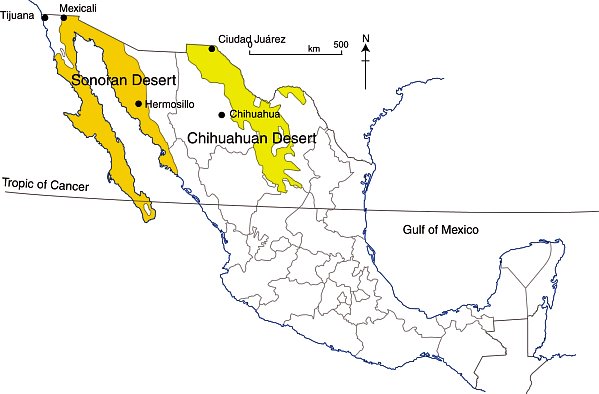
There are four desert areas in North America. Two of these areas (Great Basin and Mojave) are in the USA. The other two (the Sonoran Desert and the Chihuahuan Desert) are almost entirely in Mexico, but extend northwards across the border. The Sonoran Desert includes most of the Baja California Peninsula, together with the western part of the state of Sonora. The Chihuahuan desert is the northern section of the Central Plateau, including the northern parts of the states of Chihuahua.

The Chihuahuan Desert has been intensively studied by scientists interested in the possibility of life on Mars – see this New York Times article: Learning About Life on Mars, via a Detour to Mexico.

In a previous post – Why is northern Mexico a desert region? , we saw how the combination of the descending air of the Hadley Cell, which results in surface high pressure, and the effects of rain shadows resulting from neighboring mountain ranges contribute to the low annual rainfall total characteristic of both Mexico’s desert areas.

deserts-colorWhile these two deserts both experience an arid climate, they also have many differences.

Area

The Sonoran Desert has an area of about 311,000 square kilometers (120,000 sq mi). The Chihuahuan Desert has an area of about 362,000 square kilometers (139,769 sq mi).

Elevation

The Sonoran Desert is lower in elevation that the Chihuahuan Desert, with some parts (in the USA) lying below sea level. The Chihuahuan Desert varies in elevation from 600–1675 m (1969–5495 ft).

Summer temperatures

The Sonoran Desert tends to have higher summer temperatures than the Chihuahuan Desert, though even in the Chihuahuan Desert, daytime temperatures in summer are usually between 35 and 40̊C (95-104̊F).

Seasonal rainfall patterns

The ratio of winter to summer rainfall decreases from west to east. Most of the Sonoran Desert (to the west) has a bimodal rainfall regime with spring and summer peaks. On the other hand, most of the limited rain that falls in the Chihuahuan Desert comes in late summer.

The Chihuahuan Desert has a mean annual precipitation of 235 mm (9.3 in), though annual totals vary from 150 to 400 mm (6–16 in).

Vegetation, fauna and biodiversity

These seasonal rainfall differences result in significant differences in the vegetation of the two areas.

The bimodal precipitation in the Sonoran Desert provides two flowering seasons each year. Some plants bloom in spring, following winter rains, while others flower in late summer, following summer rains. Typical plants in the Sonoran Desert include columnar cacti (Cereus spp.) such as sahuaro, organ pipe, and cardon, as well as many other types of cacti, including barrels (Echinocereus), chollas (Opuntia spp.) and prickly pear (Opuntia spp.). Other succulent plants are also common.

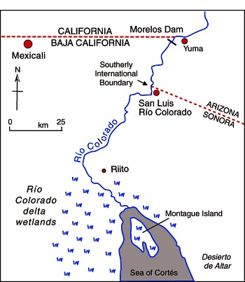
More than 60 mammal species, 350 bird species, 20 amphibian species, 100 reptile species, 30 native fish species, 1000 native bee species, and 2000 native plant species have been recorded in the Sonoran Desert. The Sonoran Desert includes the Colorado River Delta, which was once an ecological hotspot within the desert, fueled by the fresh water brought by the river, though this flow has become negligible in recent years. See, for example, Will the mighty Colorado River ever reach its delta?

The vegetation of the Chihuahuan Desert is dominated by grasslands and shrubs, both evergreen and deciduous. Common species include tarbush (Flourensia ternua), whitethorn acacia (Acacia constrictor) and creosote bush (Larrea tridentata). The Chihuahuan desert has small cacti; succulent agaves (Agave spp.) and yuccas. Plants bloom in late summer, following the summer rains.

The Chihuahuan Desert is home to about 350 of the world’s 1500 known species of cactus, and includes the fascinating area of Cuatro Ciénegas, which has an unusually high number of endemic plant species and is one of the world’s richest hotspots for locally endemic cacti.

The Chihuahuan Desert is considered to be one of the three most biologically rich and diverse desert ecoregions in the world, rivaled only by the Great Sandy Tanmi Desert of Australia and the Namib-Karoo of southern Africa. However, settlements and grazing have heavily degraded the natural vegetation of some parts of the Chihuahuan Desert.

he Chihuahuan Desert has about 3500 plant species, including up to 1000 species (29%) that are endemic. The high rate of endemism (true for cacti, butterflies, spiders, scorpions, ants, lizards and snakes) is due to a combination of the isolating effects of the basin and range topography, climate changes over the past 10,000 years, and the colonization of seemingly inhospitable habitats by adaptive species. See here for more details of the flora and fauna of the Chihuahua Desert.

Landforms

This basin and range landscape of the Sonoran Desert trends north-northwest to south-south-east. Parallel faulted blocks are separated by alluvial bajadas (broad, debris-covered slopes), pediments and plains, which become wider approaching the coast. Despite being a desert area, this region exhibits many features that have resulted from water action, including wadis, salt flats, stream terraces and alluvial fans.

For a fuller description of the landforms of the Sonoran Desert, see this extract from A Natural History of the Sonoran Desert (edited by Steven J. Phillips and Patricia Wentworth Comus) published by the Arizona-Sonora Desert Museum.

The Sonoran Desert includes the subregion of the Sierra of Pinacate (part of El Pinacate and Gran Desierto de Altar Biosphere Reserve) with its distinctive volcanic cones, craters and lava flows. For more details, see The landforms of the El Pinacate and Gran Desierto de Altar Biosphere Reserve.

The landforms of the Chihuahuan Desert have been molded by tectonic uplift and erosion. Steep-sided but low hills are separated by wide bajadas from former lake beds and alluvial plains, occupying inland basins known as bolsons. Many parts form closed, interior basins with no external drainage. South of Ciudad Juárez, at Samalayuca, is one of Mexico’s most extensive areas of sand dunes. This is one of the most arid parts of the country, with high levels of salinization.

Related posts:

May 262014
 

In a recent post – Mexico’s internet connections and e-commerce – we looked at how 35.8% of Mexican households now have computers, 30.7% are now connected to the internet, and at the very rapid rise of e-commerce over the past few years.

How does internet access in Mexico compare to other countries? Comparative studies show that Mexico lags well behind almost all major countries in terms of internet access. Mexico’s rate of 30.7% of households with internet access compares poorly with other countries in Latin America such as Brazil (37.8%), Chile (37.8%) and Argentina (34.0%).

Among OECD member states, Mexico ranks bottom in terms of internet access. South Korea ranks top, with 97.2%. The Netherlands, Norway, Iceland, Luxembourg, Sweden and Denmark all have rates over 90%. Canada has a rate of 78.4%, the USA 71.1% and Japan 67.1%. The lowest ranking European countries are Turkey (41.6%), Greece (50.2%) and Portugal (58.0%).

Within Mexico, the rate of internet access varies widely from one state to another (see graph).

Percentage of households with internet access

Percentage of households with internet access. Source: INEGI (2014)

The disparities are evident from the graph, but the pattern becomes much clearer when the data are grouped and mapped:

Internet access, 2013

Pattern of internet access, 2013. Data: INEGI. Credit: Geo-Mexico

The north-south divide in Mexico, that we have frequently referred to in previous posts, is immediately evident (with the notable exception of the easternmost state of Quintana Roo). Perhaps not surprisingly, there is a close correlation between GDP/capita in different states and their internet access.

Discussion question:

What other factors are likely to influence rates of internet access? To support, or challenge your ideas, try using Geo-Mexico’s map index to find maps to compare with the map of internet access.

Source of data:

  • Estadísticas a Propósito del Día Mundial de Internet” (pdf file) (INEGI 2014)

Related posts:

May 242014
 

This guest post, by C.G. Machlan of the fledgling Green City Development Organization, looks at the feasibility and practicality of establishing sustainable, accessible cities in Mexico.

If it is feasible and practical to build wind farms in Mexico then it must also be feasible and practical to build sustainable, accessible Green Cities. Here’s why!

Mexico has sufficient wind and solar resources as indicated by these two maps, of wind resource and solar radiation respectively:

Mexico-Wind-Map-2

Source: http://www.altestore.com/howto/images/article/Mexico-Wind-Map.jpg

energia-solar-mexico

Source: http://www.evwind.com/wp-content/uploads/2013/03/energia-solar-mexico.jpg

Wind Farms

Mexico has approximately 31 wind farms occupying over 11,000 hectares in 8 states, generating more than 1,300 megawatts (MW) of power for the national grid system. Additional wind farms are in the planning and development stages. These wind farms are needed, and are an important component of efforts to increase Mexico’s electricity-generating capacity. Wind farms are ecologically clean, produce needed electricity for the national grid, reduce Mexico’s carbon footprint, and create some long term jobs.

Green Cities versus Wind Farms

While wind farms contribute to Mexico’s electricity-generating capacity they do little to help the long term employment situation in Mexico. On the other hand, Green Cities can help boost employment. The Green City Feasibility Study looked at 10 Mexican states and identified potential locations having sufficient wind, solar and moisture resources to support a Green City. When built, each city would be able to house an estimated population of 250,000 to 300,000, and could create more than 100,000 new jobs across all sectors. Each city would be totally sustainable as regards electricity, by incorporating vertical and horizontal wind turbines together with solar panels in both residential and non-residential areas.

The Green City Electrical Analysis suggests that a Green City will require 54.6 to 63.3 megawatts daily for an estimated 54,000 houses, and between 288 and 661 MW for the non-residential areas at the projected mean and maximum population levels. This is a similar number of megawatts to the 250 MW produced by the Eurus Wind farm located in Juchitan de Zaragoza, Oaxaca, or the 632 MW, oil fired, Puerto Libertad power plant in Pitiquito, Sonora, but has the very important additional advantage of helping to create more than 100,000 new jobs in each city.

Green City Water Sustainability

Both electricity and water are essential for any city, Green Cities included, to grow and prosper. If Green Cities are located in areas where there is good wind speed/density and sufficient solar radiation to produce the electrical energy required, then the next question becomes, “Is there enough water available?”

Annual precipitation in Mexico (Fig .4.3 of Geo-Mexico)

Annual precipitation in Mexico (Fig .4.3 of Geo-Mexico, the geography and dynamics of modern Mexico) All rights reserved.

The normal rainfall season in many areas of Mexico is from May through September, so Green Cities would need to rely on aquifers as a year-round water source. Mexico has 653 identified aquifers, more than 100 of which are said to be overexploited.

Map of overexploited aquifers and areas of salinization

Overexploited aquifers and areas of salinization (Fig 6-7 of Geo-Mexico; all rights reserved)

Fortunately, Green Cities can be totally water sustainable by:

  • Recycling all wastewater to a quality suitable for potable use.
  • Incorporating “Air to Water” methods to obtain replacement water thus reducing aquifer usage.
  • Designing runoff systems to collect and clean rainfall (stormwater) when it is available.
  • Recharging aquifers, using excess water obtained from stormwater runoff.

The Green City Water Analysis estimates that a typical Green City will consume 71,563 cubic meters of water daily. Of this amount, 48,904 cubic meters will become wastewater requiring treatment. Assuming that 10% of the wastewater is lost during processing, approximately 24,925 cubic meters of replacement water will be needed daily, which must come from an aquifer, rainwater and/or “Air to Water” methods.

Calculations indicate each city could be fully water sustainable if rainwater was efficiently harvested. Assuming 10 cities were built in the various locations identified in the feasibility study (examined in an upcoming post) as much as 128 million cubic meters of water could be available for aquifer recharging each year.

Accessibility for All Individuals

If new cities are to be built it seems logical to make them completely accessible to all individuals so everyone has equal opportunity to live, learn and work. This, too, is possible with Green Cities. All houses and non-residential buildings are designed to be totally accessible, making the cities not only unique in Mexico, but in the world!

In Closing

It is feasible, socially acceptable, and economically practical to build sustainable, accessible Green Cities in Mexico! Green Cities are especially important for Mexico. Like most other emerging and developing countries, Mexico lacks sufficient electricity-generating capacity to promote the industrial growth needed for its population. Building more wind farms can help existing cities (via the national grid) but Green Cities can provide even more long term benefits to the people of Mexico, including as many as 1 million new jobs from the construction of 10 new cities.

The technology is available. Now it requires planning, refinement, cost analysis and implementation. Is Mexico ready? We believe the answer is YES!

[Text submitted by C.G. Machlan, The Green City Development Organization (GCID.org). Mr. Machlan can be contacted via bmachlan@hotmail.com]

Join the Discussion

As always, Geo-Mexico welcomes discussion about this (and all our posts) via the comments feature. If the comments feature is not visible, simply click the title of the relevant post, and scroll down.

Pemex works at its Clean Fuels Policy

 Mexico's geography in the Press  Comments Off on Pemex works at its Clean Fuels Policy
May 222014
 

As part of its Clean Fuels Policy, Pemex is modernizing its refineries in Ciudad Madero, Minatitlán, Salamanca, Salina Cruz and Tula.The total investment involved is 3.4 billion dollars. The plan, which will take 4 years to complete, includes the construction of new plants in several of the locations

Pemex installations in Mexico. (Adapted from Fig 15.5 of Geo-Mexico). All rights reserved.

Pemex installations in Mexico. (Adapted from Fig 15.5 of Geo-Mexico). All rights reserved.

The objective is to produce Ultra Low Sulfur diesel fuel (UBA) in the five refineries, in compliance with Mexican standards. The new technology will reduce vehicle emissions of carbon dioxide and nitrogen oxides by between 50 and 80%.

Since last September, 42,500 barrels/day of ultra low sulfur gasoline is already being produced at the Pemex refinery in Cadereyta, Nuevo León.

Related posts:

May 192014
 

Both the state and the city of Querétaro are growing rapidly in importance. The state has grown faster than any other over the past decade and has attracted significant foreign direct investments, especially in the aeronautical sector, but also other technology firms attracted by the state’s central location, proximity to Mexico City, easy access to other major cities, such as Guadalajara and Monterrey, excellent transport links to the northern border and both coasts, its highly educated workforce and enviable living standards.

The state’s success has not gone unrecognized. For example, Joseph Parilla and Alan Berube of the Brookings Institution’s Metropolitan Studies Program in “Finding the ‘New’ Mexico in Querétaro” describe the state as “ground zero for the country’s economic revolution, achieving average annual GDP growth of 5.5% over the last decade, highest among Mexico’s 31 states. It is home to major multinational corporations like GE and Samsung, a burgeoning middle class, new golf courses, and what will soon be Latin America’s second-largest shopping mall, all within a stone’s throw of an immaculately preserved colonial center (a UNESCO World Heritage site).”

This recent PBS video segment looks at how economic reforms have enabled boomtowns such as Querétaro to spur economic growth in Mexico.

Two proposed projects in Querétaro deserve further comment.

The first is the announcement earlier this year that Arkansas State University was joining with private investors in Querétaro to break ground on the first U.S. university residential branch campus in Mexico. The campus is slated to be built in the municipality of Colón, some distance from the state capital. Just how significant this project is remains to be seen.

The second project, which holds much greater significance, is the renewed interest in constructing a high speed rail link capable of moving as many as 20,000 passengers/day connecting Querétaro City with Mexico City. This idea has been around for at least 20 years, but may finally be approaching lift off.

At a later stage, this line could easily be extended into the Bajío Region, to the industrial cities of León and Guanajuato, and also possibly westwards to Guadalajara. Tapatíos (the residents of Guadalajara) have dreamed of a high speed rail link to Mexico City for the past 30 years, following the demise at that time of the convenient and popular overnight train service linking the two cities.

The line’s proposed route is from the Buenavista station in Mexico City to Huehuetoca, and then mainly following the route of highway 57, the main Mexico City-Querétaro highway, to Querétaro.

The project would generate up to 9,000 direct jobs during construction and take about four years to complete at an estimated cost of $3.3 billion.

Related posts:

Mexico’s internet connections and e-commerce

 Other  Comments Off on Mexico’s internet connections and e-commerce
May 172014
 

Mexico, Argentina, Spain and another twenty countries from around the world celebrate today (17 May) as “World Internet Day”.  This seems like the ideal time to review just how “connected” (or not) Mexico’s cybernauts are.

Household survey figures from INEGI, the National Statistics Institute, show 11.1 million homes in Mexico (35.8% of the total) have a computer, but that 14% of these households do not have internet access. About 46 million Mexicans aged six years or older access the internet. Three quarters of all users are under the age of 35.

Digital divide map

Internet traffic flows Credit: Stephen Eick, Bell Labs / Visual Insights, <http://www.visualinsights.com>)

64% of users utilize the internet for information, 42% as a means of communication, 36% for entertainment, 35% for education and 35.1% for social networking. (These categories are not mutually exclusive.) 43.6% of all users access internet daily, 45.5% weekly and 7.1% less often. In terms of education, 20.2% of all users have completed primary school only, 24.5% junior high and 28.6% senior high, while 23% already have a degree and 2% have postgraduate qualifications.

Data from the Mexican Internet Association (AMIPCI) shows that Mexicans’ acceptance of e-commerce is rising very rapidly. E-commerce was worth around $9.3 billion in 2013, an increase of 41% from a year earlier when the comparable figure was $6.6 billion. Indeed, APIPCI data show that e-commerce has risen at double digit rates for several years. There is still considerable room for growth since the INEGI survey shows that only about 6% of Mexico’s cybernauts currently use the internet to make purchases or pay bills.

Related posts:

Mexico’s multinationals: KidZania and its child-sized cities

 Other  Comments Off on Mexico’s multinationals: KidZania and its child-sized cities
May 152014
 

KidZania is one of Mexico’s more unusual multinational corporations. It is a Mexican-owned chain of family entertainment centers, aimed at children aged 4 to 14. Each KidZania location is a child-sized replica of a real city, complete with buildings, paved streets, shops, vehicles and pedestrians. All buildings are scaled to be two-thirds their real-life size.

kidzania-logoChildren enter the city (usually via an airport-like setting) and then engage in role-play jobs in such branded activities as bottling Coca-Cola, serving at a McDonald’s restaurant or working in a Crest-sponsored dentist’s office. Others undertake the roles of firemen, doctors, police officers, journalists and shopkeepers, etc. “Workers” earn kidZos (local currency) to spend on entertainment, at the gift shop, or for premium KidZania activities. Each KidZania offers about 100 role-playing activities in 60 or so distinct establishments.

Between them, KidZania centers attract more than 4 million young visitors a year. This Youtube promotional video – KidZania Global Overview 2013 – provides a good introduction.

Alternatively, the 5-minute video below, from PBS’s American Milestones, describes how KidZania works, with particular emphasis on its claimed educational value:

The Mexican entrepreneur behind KidZania is CEO Xavier López Ancona. The first KidZania (later renamed La Ciudad de los Niños – The City of the Children) opened in September 1999 in Santa Fe Shopping Mall in Mexico City. Two more locations have since opened in Mexico: Monterrey, in northern Mexico, and Cuiculco, in the southern part of the Federal District.

The first KidZania outside Mexico opened as a franchise in Tokyo, Japan, in 2006. Since then KidZania has opened centers in:

  • Jakarta, Indonesia (2007)
  • Koshien, Japan (2009)
  • Lisbon, Portugal (2009)
  • Dubai (2010)
  • Seoul, South Korea (2010)
  • Kuala Lumpur, Malaysia (2012)
  • Santiago, Chile (2012)
  • Bangkok, Thailand (2013)
  • Mumbai, India (2013)
  • Kuwait (2013)
  • Cairo, Egypt (2013)
  • Istanbul, Turkey (2014)
  • London, U.K. (2015)

The chain is still expanding, with plans to establish new centers in Jeddah, Saudi Arabia; São Paulo, Brazil; Singapore; Moscow, Russia; Manila, Philippines; Doha, Qatar;  and Chicago, USA.

Each park represents an initial investment of between 20 and 30 million dollars. Sponsors of KidZania activities vary by location and include (or have included) American Airlines, Coca Cola, Domino’s Pizza, Kellogg’s, Walmart, Danone, Mitsubishi, Honda, HSBC, Johnson & Johnson, Nestlé and Sony.

KidZania has won several major awards, including one as the World’s Top Family Entertainment Center by IAAPA (International Association of Amusement Parks and Attractions).

Related posts:

May 092014
 

We have repeatedly questioned the long-term wisdom of large-scale tourist developments along Mexico’s coastline. See, for example:

The good news, in June 2012, was that it looked as if the conflict at Cabo Pulmo, in Baja California Sur, had been resolved in favor of protecting the environment:

Unfortunately, land developers won’t take “No” for an answer. Immediately after its “cancellation”, the Cabo Cortés project was renamed Los Pericúes and relaunched, with few if any differences from the original version. Two years on, the project has been taken over by a new consortium of developers and renamed “Cabo Dorado”. Some changes have been made along the way, and Cabo Dorado no longer includes a marina or desalination plant, and its plans appear to have a lower building density.

There are still some legitimate concerns about the long-term impact of such a project in this area, so kudos to Carolina Herrera (Latin America Advocate of the Natural Resources Defense Council in Washington DC) for her impassioned plea calling for Cabo Pulmo to be protected from the latest incarnation of this long-proposed tourist megaproject.

The project is located immediately north of the Cabo Pulmo Marine Park, which over its 19 year lifespan has proven to be hugely successful in conservation terms (The extraordinary ecological recovery of Mexico’s Cabo Pulmo Marine Park), while providing local people with the opportunity to offer a variety of alternative forms of low impact tourism. The site of the Cabo Dorado project site is home to 26 “at risk” species, including endemic plants and endangered sea turtles.

Cabo Dorado is a 3.6-bilion-dollar joint investment by La Rivera Desarrollos BCS, a joint venture of Glorious Earth Group (USA) and Beijing Sansong International Trade Group (China), together with China State Construction Engineering Corporation.

The project is for the construction of a new “ecotourist city” on 3770 hectares (9317 acres) of land. Slightly more than two-thirds of this area will be retained as a “conservation reserve”.

The master plan for the developed third includes:

  • 6,141 homes  (443 ha)
  • 9 hotels with 4,080 hotel rooms (721 ha) [the 22,503 number on the infographic below is an error]
  • 2 golf courses and practice ground (162 ha)
  • Services, infrastructure, maintenance (334 ha)
  • 1 landing strip
  • 1 14-km aqueduct
  • Shops, convention center, etc
Infographic from www.cabopulmovivo.org

Infographic from www.cabopulmovivo.org   Click to enlarge

According to the developers. Cabo Dorado “will be a fully integrated development, a first of its kind in the country, as it combines educational, recreational activities, scientific research, health promotional centers and a strong commitment to preserve the environment.” To this end, the project includes “an interpretation center, a technological and biological research center for studies related to the Sea of Cortes and the Desert of Baja California Sur, as well as a cultural exchange center, an educational institute and a student campus. In addition, there will be centers dedicated to the promotion of trade and investments, a high performance sports center, 9 world-class hotels and residences for temporary visitors and full time residents.”

Cabo Dorado will extract up to 4.8 million cubic meters of water a year from Santiago aquifer, roughly equivalent to the water needs of a city of 82,000 people) and will generate 711,900 kilograms of waste per day.

On the positive side, the project will create 18,000 direct and indirect jobs and bring around 900 million dollars/year into this area. It does not involve a marina or pumping wastewater into the sea which should prevent direct adverse ecological impact on marine life. The masterplan includes a “support town” for workers, which means that the local municipality does not need to build additional infrastructure to support the project.

The Mexican Center for Environmental Law (CEMDA) has called for a formal public meeting and consultation to ensure people are adequately informed about the latest plans and the potential social and environmental impacts.

Further reading:

For an exceptionally informative series of papers (in Spanish) on all aspects of tourism and sustainability in Cabo Pulmo, see Tourism and sustainability in Cabo Pulmo, published in 2008 (large pdf file).

Related posts:

Three Mexican cities among the 100 most competitive cities in the world

 Mexico's geography in the Press  Comments Off on Three Mexican cities among the 100 most competitive cities in the world
May 072014
 

Three cities in Mexico – Mexico City Metropolitan Area, Monterrey Metropolitan Area and Querétaro – are included on the 2013 list of “The World’s Most Competitive Cities. A Global Investor’s Perspective on True City Competitiveness”, a report issued by Site Selection magazine in cooperation with IBM Global Business Services.

It is the first time the city of Querétaro (2010 population: 805,000) has been included on the list; Mexico City and Monterrey are old-timers on the list.

The 100 cities studied all have a minimum population of 1 million inhabitants in the local labor catchment area and attracted at least 25 foreign investment projects in 2009-2011. The study aims to rank the competitiveness of cities “to attract investment and international projects in various sectors”, and to identify those locations with the best combined “cost-quality” for particular types of investment project.

The report presents rankings and findings for five different types of operations:

  • International headquarters, coordinating corporate operations in a global region
  • Financial services center of competence
  • Software development center
  • R&D center for life sciences, combined with pilot production
  • Shared services center, providing support for corporate operations in finance, customer support, human resources or IT
Criteria used to rank world's 100 most competitive cities

Criteria used to rank world’s 100 most competitive cities

Rankings are based on 30 factors or parameters (see chart above).

The most competitive cities in the world were London, U.K. (score of 78.0), Singapore (78.5), New York City (77.4), Amsterdam (76.3) and Hong Kong (75.9).

Mexico City Metropolitan Area was ranked as number 57, with a score of 55.8. Monterrey Metropolitan Area ranked number 72 (48.2) and Querétaro city ranked number 90 (43.6).

Related posts:

Mexicans drink more bottled water per person than anywhere else in the world

 Updates to Geo-Mexico  Comments Off on Mexicans drink more bottled water per person than anywhere else in the world
May 032014
 

Mexicans are the world’s largest consumers of bottled water, both in individual small bottles (1.5 liters or less) and in garrafones (large, 20-liter bottles).

The main reason is a lack of confidence in the purity of public water supplies, resulting in part from perceived inefficiencies in how city water systems are managed and maintained. These concerns may be valid in some parts of Mexico, but are certainly not the case in all areas. Other factors resulting in a high acceptance of bottled water are the convenience, Mexico’s warm climate, and the vigorous publicity and advertising campaigns carried out by bottled water companies. It does not help that consumer groups repeatedly express concerns even about the quality of water in garrafones, claiming that some companies apparently take insufficient precautions to prevent its contamination.

For its part, the National Water Commission repeatedly claims that the problem of water quality is not due to the main distribution lines in Mexico, but to problems at a local level, in the final stages of the network between supply and consumers.

garrafon

Typical 20-liter garrafon

According to Euromonitor International, bottled water consumption in Mexico in 2013 averaged 186.7 liters/person, well ahead of Italy (175.1 liters/person), Nigeria (163.1), Turkey (147.7) and Spain (143.2). [Note that an earlier estimate in 2010 by Beverage Marketing Corporation put per person consumption of bottled water in Mexico at 234 liters a year, with equivalent figures for Italy, Spain and the USA of 191 liters, 119 liters and 110 liters respectively; the difference from 2010 to 2013 is almost certainly due to methodological differences].

Mexico consumes about 13% of all bottled water sold in the world! The only countries consuming more bottled water (in total volume) than Mexico were the much more populous countries of the USA, China and Nigeria.

Bottling water is a highly profitable business. The cost of 1,000 liters from the tap is 25 pesos (about 2 dollars); the same water, sold in bottles, is worth between 6000 and 8500 pesos (450 to 650 dollars).

The bottled water market in Mexico has grown from 6.5 billion dollars in 2009 to 10.4 billion in 2013, according to Euromonitor.  It is dominated by three foreign firms: Danone (France), Coca-Cola (USA) and PepsiCo (USA). Between them, they supply 82% of the market, according to a Euromonitor report, with the three leading brands being Bonafont (Danone) which accounts for 38% of the market, followed by Ciel (Coca-Cola) which has a 25% share and Epura (PepsiCo) 19%.

The cost of bottled water in an average Mexican household is considerable. For instance, assuming an average consumption of 15.55 liters/month/person, and that all water is bought in 1-liter bottles (which cost about 8 pesos each), then the monthly cost per household would be close to 500 pesos (38 dollars).

An industry dominated by four multinationals

Inside the Bottle: An Exposé of the Bottled Water Industry, a book by Canadian activist Tony Clark, provides a vivid and disturbing portrayal of how, worldwide, four big companies – Nestlé, PepsiCo, Coca-Cola and Danone – dominate the bottled water industry. As summarized by infinitewaterinc.com, the book examines several key issues of public concern about the operations of these companies, including how they:

  • pay little or nothing for the water they take from rural springs or public systems;
  • turn ‘water’ into ‘water’ through elaborate treatment processes;
  • produce a product that is not necessarily safer then, nor as regulated as, tap water;
  • package it in plastic bottles made of environmentally destructive toxic chemicals;
  • market it to an unsuspecting public as ‘pure, healthy, safe drinking water’; and
  • sell it at prices hundreds, even thousands of times more costly than ordinary tap water.

Related posts:

The 10 richest Mexicans in 2014

 Mexico's geography in the Press  Comments Off on The 10 richest Mexicans in 2014
May 012014
 

Carlos Slim Helú , director of Grupo Carso, continues to head the list of the 10 richest Mexicans, despite his fortune declining in 2013 due to the falling value of his holdings in Frisco mining company and América Móvil. Slim Helú was overtaken as the world’s richest person in 2013 by Bill Gates.

According to Forbes magazine, between them, these ten Mexicans have a fortune of 132.9 billion dollars, equivalent to 11% of Mexico’s GDP.

The top 10 are:

  1. Carlos Slim,  72 billion dollars
  2. Germán Larrea, mining, 14.7 billion dollars.
  3. Alberto Bailleres, mining, 12.4 billion dollars.
  4. Ricardo Salinas Pliego, Grupo Salinas (TV Azteca, Elektra, Banco Azteca) 8.3 billion dollars.
  5. Eva Gonda de Rivera, Coca Cola-Femsa shareholder, 6.4 billion dollars.
  6. María Asunción Arumburuzabala, former president of Grupo Modelo, 5.2 billion dollars.
  7. Antonio del Valle Ruiz, Mexichem, Pochteca y Banco Ve por Más, 5.0 billion dollars.
  8. Jerónimo Arango, whose family founded Aurrerá, 4.2 billion dollars.
  9. Emilio Azcárraga Jean, Televisa, 2.6 billion dollars.
  10. David Peñaloza Sandoval, construction firm Triturados Basálticos (Tribasa), 2.1 billion dollars.

Related posts:

Apr 282014
 

Environmental noise is everywhere in Mexico, from traffic and fiestas to garbage collection and gas delivery. For more examples, see The distinctive sounds of Mexico’s towns and cities and The Sounds of Mexico. The traffic whistles made by police are an important subset of the sounds in any Mexican town or city. They have a mini-language of their own, explored in this MexConnect article: Did you know that different traffic whistles in Mexico mean different things?

This 3 minute Youtube video is a fun introduction to some of the Sounds of Mexico City though it must be admitted that some of the sounds are far more melodious than others:

Sounds and whistles may be very useful, but exposure to environmental noise can have deleterious effects on an individual’s well-being. Research in many countries has supported legislation to limit people’s exposure to loud noise on the grounds that such exposure can seriously damage health. Working days are lost and the resulting healthcare costs are considerable.

For example, a Spanish group, The National Association Against Noise Pollution, claims that the volume of music blasting out of automobile speakers makes many of that country’s younger generation “candidates for deafness”. The Association has lobbied for “coherent and efficient” legislation to prevent this modern urban environmental problem. It wants buildings with improved sound insulation and building codes which take account of the “sound maps” of each city.

Environmental noise, even if not sufficiently loud to damage our hearing, can make communication much more difficult, not to say frustrating, and can also interfere with our concentration, increasing the likelihood of potentially dangerous situations in the workplace or on the road. Excessive noise can increase stress and provoke fatigue.

What level of noise is safe? Three factors come into play. First, how intense, or loud, the noise is. This “noise level” is relatively easy to record and is measured in decibels (dB). The second factor is how long the noise lasts – the duration of any particular noise makes a huge difference to its effects on our hearing system. This is also relatively easy to quantify. The third factor – our individual susceptibility to noise – remains extremely difficult to predict in advance, meaning that noises that prove innocuous for some members of the family may permanently damage the hearing of others.

The following list indicates the peak decibel level (dBA) of various recreational and environmental noises:

  • Normal breathing: 10
  • Average home interior: 50
  • Conversational speech: 65
  • Vacuum Cleaner: 85
  • Lawn Mower: 95
  • Video Arcade: 105
  • Car horn: 110
  • Center of Guadalajara: 110
  • Screaming child: 115
  • Chain saw: 125
  • Automobile Stereo: 125-155
  • Fireworks (at range of 3 feet or 1 meter): 162
  • Hand gun:  165

This list clearly suggests that it is unwise to spend all day mowing the lawn or vacuuming your house, let alone using a chain saw or cruising the streets with your car stereo turned up high!

The World Health Organization (WHO) currently considers that 65 decibels (65 dB) should be the maximum noise level to which people are exposed for any prolonged period of time such as a working day. It estimates that at least 120 million people worldwide, mainly city residents, are suffering from hearing problems caused by exposure to excessive noise.

Mexico’s official noise norm NOM-081-SEMARNAT-1994 was first published in 1995 and follows the WHO guidelines. By comparison, the U.S. Occupational Safety and Health Administration standards are a maximum 8 hours exposure to 90 dB, 2 hours exposure to 100 dB, 1 hour to 105 dB or 15 minutes to 115 dB.

noise-chartIn November 2013, Mexico modified the technical details attached to its noise norm, and issued a new chart (see above) showing the maximum permitted noise levels in a variety of different settings. Note that the limits apply to “fixed sources” of noise, not to the occasional passing vehicle with loud-speakers!

The new rules are welcome. As John Pint eloquently puts it in New Federal Norms list decibel limits, this legislation “gives ordinary people a chance to defend themselves from Acoustic Terrorism.”

Related posts:

Industrial development in the state of Hidalgo

 Mexico's geography in the Press  Comments Off on Industrial development in the state of Hidalgo
Apr 262014
 

A 200-million-dollar industrial development project known as Plataforma Logística de Hidalgo (PLATAH) in the central Mexican state of Hidalgo is being promoted as the nation’s latest industrial growth pole. The site’s major advantages are its proximity to Mexico City (30-40 minutes away by road) and its location alongside railways and the Arco Norte highway, which link the region to ports on both the Gulf Coast and the Pacific (see map).

platah-locationPLATAH is being developed by the Hidalgo state government in association with Artha Capital. In its initial stages, a 340-hectare site in Villa de Tezontepec, near Tizayuca, includes industrial sites and multimodal transport interchanges, supported by commercial areas and facilities for education, healthcare and business tourism.

PLATAH is projected to generate up to 10,000 new direct jobs. It is claimed that by providing employment in the region, the industrial park will reduce the need for workers to migrate or commute elsewhere for jobs, saving an estimated 8 million man-hours a year. The first factories in PLATAH are expected to be operational by early next year.

Related posts:

The resort city of Cancún continues to grow

 Updates to Geo-Mexico  Comments Off on The resort city of Cancún continues to grow
Apr 232014
 

The resort of Cancún in Quintana Roo is celebrating its 44th birthday this year. Local officials have arranged a series of events between 19 and 27 April, including an exhibition of vintage cars, to mark the occasion.

The construction of the purpose-built resort Cancún, planned by the Federal Tourism Development Agency FONATUR, began in 1970:

The tourist part of the city has thrived. Cancún now has more than 3000 condominium units, luxury shopping centers, restaurants, museums, discos, bars, an international airport and more than 150 hotels, with 35,087 hotel rooms.

In 2013, some 14 million visitors passed through the airport. Hotels had a profitable 2013, with an average room occupancy of 77.2%. Visitors to Cancún contributed an estimated 4.36 billion dollars to the local economy. Tourism provides direct employment in Cancún for around 52,600 people, and indirect employment for 175,000.

Cancún by Arthur Gonoretzky (Flickr)

Cancún by Arthur Gonoretzky (Flickr)

There is a less rosy side to Cancún. Besides the obvious adverse impacts of so many tourists, there are many other issues arising from the extraordinarily rapid growth of tourism in this area. For example, see Beach erosion in the tourist resort of Cancún, Mexico.

For a fuller discussion of the issues associated with 40 years of tourist development in Cancún, see “Ending a Touristic Destination in Four Decades: Cancun’s Creation, Peak and Agony“, which appeared in a 2013 special issue of the International Journal of Humanities and Social Science.

Tourism aside, perhaps the biggest single issue is in the “regular” city of Cancún (as opposed to the tourist zone). Cancún city (2010 population: 628,000, but sometimes claimed now to be more like 800,000) is where most supporting services are located, and most workers live. The city has grown so fast that it lacks sufficient services and fails to offer a good quality of life for its residents.

Related posts:

Pemex defines its priority areas for oil and gas

 Updates to Geo-Mexico  Comments Off on Pemex defines its priority areas for oil and gas
Apr 212014
 

Recent reforms to the energy sector have meant that Pemex has had to define its priority areas, those areas where it wishes to continue exploration and development. At a later date, it is then possible for the government to ask for bids from other oil companies, and award contracts to explore and develop oil and gas fields in other areas of Mexico. The first stage is known as Round Zero.

In March, Pemex published its portfolio of areas for exploration for “Round Zero” (Ronda Cero), with preliminary data for 2P (proven, probable) and 3P (proven, probable, possible) reserves as of the start of this year. 2P reserves totaled 24.174 billion barrels of crude equivalent, while 3P reserves totaled 43.8 billion barrels. The figures, slightly lower than the equivalent figures from January 2013, have not yet been confirmed by independent auditors.

Map from Pemex "Round Zero" document

Map from Pemex “Round Zero” document

46% of probable reserves are located in Chicontepec (Proyecto Terciario del Golfo) in Veracruz, and 43% in offshore regions including the Akal, Balam, Ayatsil, Maloob, Kunah and Tsimín fields.

56% of possible reserves are located in Chicontepec, and an additional 34% in offshore regions.

Related posts:

Apr 182014
 

A major earthquake struck southern Mexico at 7:27 local time on Friday 18 April 2014. The effects of the earthquake, which had its epicenter in Guerrero, were felt at least as far away as Mexico City. Authorities in the states affected, which include Guerrero, Morelos, México, Puebla, Oaxaca, Querétaro, Veracruz, Jalisco, Michoacán, Tlaxcala, Guanajuato, Hidalgo, Colima and the Federal District, have reported only minor damage, and no loss of life.

The preliminary report from Mexico’s National Seismological Institute says that the earthquake had a magnitude of 7.0, with an epicenter 31 kilometers northwest of Tecpan in Guerrero, and occurred at 7:27 a.m. local time. The earthquake occurred at a depth of 10 kilometers.

Initial reports from the U.S. Geological Survey (including a map) are that the earthquake was 7.5 magnitude, and at a depth of around 48 kilometers (30 miles). The USGS has since downgraded the magnitude to 7.2.

First hand reports from Mexico City say that power went off in several areas in the north of the city, and that cell phone communications were also down in some areas. The Federal Electricity Commission reported 6 hours after the earthquake that power had been restored to 98% of the 1.2 million people affected in the Mexico City Metropolitan Area. Some windows have been shattered, and there are a handful of reports of minor structural damage, including 15 walls that collapsed and 48 buildings that suffered some damage. The city was quieter than normal because of the Easter holidays, during which many city dwellers take vacations at the beach.

The most serious damage in Mexico City appears to have been in the Morelos residential complex in colonia Doctores, where the residents of two of the 14-story buildings have apparently been evacuated following reports of cracks in walls and passageways, and the separation of some stairways. Following a formal building inspection, one of the buildings will not be reoccupied prior to remedial work being carried out.

Residents of Mexico City received 65 seconds warning via Mexico’s advanced Seismic Alert system (Sistema de Alerta Sísmica), which functioned precisely as it was designed to. There were more than twenty aftershocks in the five hours after the initial earthquake, the largest of which was magnitude 4.8.

George Dunn in Puerto Vallarta (see comments) reports that buildings at the Bay View Grand were evacuated. “but all is well”. Many tourists in Puerto Vallarta and Acapulco left their hotel rooms temporarily during the quake which lasted about one minute.

In Guerrero, it is reported that the highway between Acapulco and Ixtapa-Zihuatanejo is temporarily closed to traffic while inspections are carried out of a bridge near Tecpan, where the road shows a marked displacement (see image), and the rubble from several small landslides is removed. [Update: 9 May 2014: A second earthquake of magnitude 6.4 on 8 May has caused the bridge to collapse completely. The bridge, known as “El Cuajilote” is located at km 111 of the federal highway between Acapulco and Zihuatanejo.]

road-fracture

Later on Friday, officials of Guerrero state acknowledged that many public buildings in the state suffered damage from the earthquake. In Petatlán, near the epicenter, at least 100 homes were damaged. In the state capital of Chilpancingo, several walls collapsed, at least three homes and the tower of the Santa María de la Asunción cathedral suffered some damage.

As a precaution, the main (tourist) dock in Zihuatanejo has been closed, pending a formal inspection, but is expected to be back in operation within the next day or two.

Curious coincidence: The earthquake came exactly 108 years to the day after the Great San Francisco Earthquake of 1906.

We will continue to update this post periodically over the next few days to reflect any significant changes.

Related posts:

Hurricane names and forecast for 2014

 Mexico's geography in the Press  Comments Off on Hurricane names and forecast for 2014
Apr 172014
 

The 2014 hurricane season in Mexico for Pacific coast storms starts on 15 May and lasts until 30 November. For Atlantic storms, the hurricane season extends from 1 June to 30 November, though most hurricane activity is concentrated in the months from July to September. Hurricanes are also known as typhoons or tropical cyclones.

In 2013 only two hurricanes (Manuel and Ingrid) hit Mexico, but they hit simultaneously in September, leading to more than 100 storm-related deaths and millions of dollars worth of property damage in several states, especially Guerrero.

The table shows the World Meteorological Organization’s official list of 2014 hurricane names. Note that male and female names alternate. Names are often reused in future years, with the exception of the names of any particularly violent storms, which are officially “retired” from the list for a long time.

2014 Hurricane Names for the Atlantic, Gulf of Mexico and Caribbean
ArthurGonzaloLauraRene
BerthaHannaMarcoSally
CristobalIsaiasNanaTeddy
DollyJosephineOmarVicky
EduourdKylePauletteWilfred
Fay

2014 Hurricane Names for the Eastern Pacific
AmandaGenevieveMarinaTrudy
BorisHernanNorbertVance
CristinaIselleOdileWinnie
DouglasJulioPoloXavier
ElidaKarinaRachelYolanda
FaustoLowellSimonZeke

For the Atlantic coast, Mexico’s National Meteorological Service (Servicio Metrológico Nacional, SMN) is expecting 10 named storms: 3 tropical storms, 5 moderate hurricanes (1 or 2 on the Saffir-Simpson scale), and 2 severe hurricanes (3, 4 or 5 on the Saffir-Simpson scale).

In their early season forecast for this year, Philip Klotzbach and William Gray, researchers at Colorado State University,  expect hurricane activity in the Atlantic to be significantly below the 1981-2012 average. They write that, “The tropical Atlantic has… cooled over the past several months, and the chances of a moderate to strong El Niño event this summer and fall appear to be quite high…. Historical data indicate fewer storms form in these conditions.” They predict that in the 2014 season 9 named storms will form in the Atlantic: 6 tropical storms, 2 moderate hurricanes (1 or 2 on the Saffir-Simpson scale), and 1 severe hurricanes (3, 4 or 5 on the Saffir-Simpson scale). These forecasts will be updated on 2 June and 31 July.

saffir-simpson-scalePacific Ocean hurricanes tend to be more common in El Niño years, so this year may be more active than usual. For the Pacific coast, Mexico’s National Meteorological Service (Servicio Metrológico Nacional, SMN) is expecting 15 named storms: 5 tropical storms, 7 moderate hurricanes (1 or 2 on the Saffir-Simpson scale), and 3 severe hurricanes (3, 4 or 5 on the Saffir-Simpson scale). The SNM publishes regular updates on hurricane activity (in Spanish) on its webpage and via its Twitter account: @huracanconagua.

How accurate was the 2013 forecast?

The early season (May) prediction for 2013 (last year) was for 18 named storms in the Atlantic: 9 tropical storms, 5 moderate hurricanes and 4 severe hurricanes. This prediction proved to be the least accurate forecast in recent years. In reality, the 2013 Atlantic season had 14 named storms: 1 tropical depression, 11 tropical storms, 2 moderate hurricanes and 0 severe hurricanes. Klotzbach and Gray have since looked at the possible reasons for the poor forecast and concluded that, “It appears that the primary reason was the most significant spring weakening observed since 1950 of the Atlantic thermohaline circulation.” A summary of their findings is available here.

Related posts:

The diary of a food activist’s visits to Mexico

 Books and resources  Comments Off on The diary of a food activist’s visits to Mexico
Apr 142014
 

Food activist Jill Richardson, author of Recipe for America: Why Our Food System is Broken and What We Can Do to Fix It, has a blog called Jill Over the Ground (formerly La Vida Locavore – Locavores being people interested in eating food that is locally produced, and has not traveled long distances.)

Richardson, who serves on the policy advisory board of the Organic Consumers Association, visited Mexico twice in 2010 and has published an interesting online diary of her trips. Richardson visited the two contrasting states of Jalisco and Chiapas. In the former wealthy state, she was able to spend some time in the agricultural community of Cuquio. Her purpose on this trip was “to learn about the impacts of the Green Revolution and NAFTA on corn production there.” Later in the year she visited Chiapas, a far less wealthy state, during the time of the coffee and corn harvests, “working with and learning about the Zapatistas (an indigenous insurgent group).”

Educational level of farmers in Mexico, 2007

Educational level of farmers in Mexico, 2007. Credit: LaVidaLocavore.com

Following her trips, Richardson compiled a page summarizing agricultural statistics for Chiapas, Jalisco and Cuquio, based on Mexico’s 2007 Agricultural Census. The page has numerous tables and graphs about everything from crops grown and machinery used to irrigation, access to insurance, living conditions and other sources of household income.

Agriculture in Cuquio, 2010

Agriculture in Cuquio, 2007. Credit: LaVidaLocovore.com

Richardson’s passion for produce that is organic and locally produced is admirable. The anecdotes in her diary entries are well told, and raise important issues about the overuse/abuse of pesticides and fertilizers,the exploitation of farmers, microlending and a host of other factors that caught her attention. While her diaries are certainly not a comprehensive analysis of agriculture in the areas she visited, they do shed some light on some of the important issues facing farmers there. The diary entries are worth reading for the many examples and photographs included.

Her diary entries include:

I should note that despite Richardson’s impassioned and persuasive writing, I’m not actually in agreement with her advocacy for locavorism. I find myself more in agreement with the reviewer of her book who wrote that, “The author’s rabid advocacy of locavorism is especially myopic; she brushes past the costliness and impracticality—When buying eggs I ask the farmer how many chickens they own and if these chickens are on pasture—and ignores critics who argue that locavorism is an energy-inefficient fad.” (See The energy efficiency of farming in Mexico and elsewhere.)

That said, Richardson’s online diary is a very useful resource and likely to be a valuable starting point for many classroom discussions.

Related posts

Geo-Mexico has many other agriculture-related posts (easily found via our tag system). They include posts about the geography of growing/producing cacao, honey, sugarcane, coffeeChristmas trees, chiles, floriculture, tomatoes, tequila, horticultural crops and oranges.

Apr 122014
 

On Thursday, 27 March 2014, Mexican and U.S. officials were on hand to witness a release of water from the Morelos Dam (located on the border, see map) that should help to rejuvenate wildlife in the Colorado River delta. The delta area has been dry for many years.

Map of the Colorado delta

Map of the River Colorado delta. All rights reserved. Click to enlarge.

The agreement between Mexico and the USA allows for a “pulse flow” of water to be released down the Colorado River, which will bring water to the river’s delta in the Sea of Cortés (Gulf of Mexico) for the first time in more than five decades. The pulse is designed to mimic the effects of a springtime snow melt. The pulse flow will amount to a total of 130 million cubic meters of water over a period of eight weeks.

Within 48 hours of the initial release, the water had reached about 50 km (30 miles) downstream, with some of the water infiltrating into the barren soil as it went. The scientists monitoring the release are still unsure whether or not any water will make it as far as the sea, but already there are signs of life returning to the delta region:

  • Update From Colorado River Delta: A Community Gets its River Back

The release of water is part of a pilot project, due to last five years, that will lay the groundwork for possible future agreements to ensure that the delta area receives sufficient water in the future to enable its fauna and flora to survive.

For more about this landmark event, see

You can help restore water to the Colorado River Basin by joining (free) Change the Course, a project of National Geographic and partners. 

Related articles: