admin

Mar 112010
 

Some of Mexico’s key population indicators are listed below, with the latest estimates of the 2010 values for each indicator:

  • Total population –  108.4 million
  • Crude birth rate  – 17.8 / 1,000
  • Crude death rate – 5.0 / 1,000
  • Natural population growth rate – 1.28%/yr
  • Infant mortality rate – 14 / 1,000 live births
  • Total fertility rate – 2.1 children per woman of reproductive age
  • Life expectancy – 75 years (male  73 ; female 78)

Table 9.1 of Geo-Mexico: the geography and dynamics of modern Mexico provides values for each of these indicators for the period from 1900 to 2000 inclusive, together with estimates (projections) for the period from 2010 to 2050.

Click here for a post about Mexico’s population age-sex pyramids for 1990, 2010 and 2050.

Mar 102010
 

As mentioned in a previous post about tourist guidebooks, the introduction of railways into Mexico and the gradual expansion of the railway network encouraged the development of all kinds of social, industrial and tourist activities.

The Mexico City-Puebla line was completed in 1886 and went via the small town of Cuautla in the state of Morelos. Cuautla is about 25 kilometers south-east of Cuernavaca.

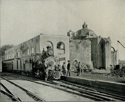
In Cuautla, the builders of the railway found a perfect location for the town’s new station, very close to the center. They station was constructed around the cloisters of an abandoned building, the former Dominican convent of San Diego, which dated back to 1657. Its ecclesiastical life ended some years before parts of it were incorporated into the railway station in 1881.

The 1899 edition of Reau Campbell’s famous Guide provides an idea of what visitors to Cuautla could expect when the train was in its heyday:

The train stops some minutes in Cuautla and there may be time for a walk through the little alameda, just outside of the station, where there are trees and flowers, a hotel where there are good wines, coffee and lunches to be had. As the approach to the station has been through a grove of tropical trees and gardens, so is its departure, and the train continues southward through the cane country to Yautepec…

A decade later, the British-born journalist William English Carson (1870-1940) spent four months in Mexico. Carson also visited Cuautla:

It is a quaint, old-fashioned place, with narrow, cobble-paved streets, and houses of the usual low, flat-roofed type. As I strolled about the town the next morning, I noticed some unusually amusing signs of Americanization. An enterprising barber, for example, displayed a big signboard with the English inscription, “Hygienic, non-cutting barber shop,” as a tempting inducement to tourists, and one or two other establishments displayed in their windows the interesting announcement, “American spoke here.”

The Oldest Railway Station in the World. Cuautla. Inter-Oceanic Railway (from Carson).

Carson also describes the railway station:

Cuautla is also famous for having the oldest railway station in the world, the crumbling, ancient structure which is now used for this purpose having been the Church of San Diego built in 1657. … The day after my arrival I went into the old church, the body of which is now used as a warehouse, while one side of it bordering the railway line provides accommodation for the waiting-room and various offices. A quantity of wine-barrels were piled up at the spot where the high altar had formerly stood, and all kinds of merchandise were stored in other parts of the building. Over the door was an inscription, the first words of which seem appropriate enough to the present condition of the once sacred edifice: “Terribilis est iste hic domus dei et porta coeli ” (How dreadful is this place. This is none other but the house of God and this is the gate of heaven).

In October 1973, the original narrow gauge track from Mexico City to Cuautla was replaced with standard gauge line, bringing a premature end to the lives of several steam engines. These engines were among the very last steam locomotives used in regular service anywhere in North America. Fortunately, the oldest section of narrow gauge in Mexico, built between Amecameca and Cuautla still survives. Originally built in 1881 as the Ferrocarril Morelos (Morelos Railroad), it was partially re-opened, between Cuautla and Yecapiztla, for a tourist steam train service in July 1986, using engine #279 and four restored second class coaches. Engine 279 is a Baldwin locomotive, built in Philadelphia, first brought into service in 1904, and now spends most of its time resting contentedly in the Cuautla museum, the museum that is housed in the oldest building ever used as a railway station anywhere in the world.

Postscript: The rival claims of Red Hall, Bourne, U.K. to be the oldest station building in the world

I am very grateful to Tony Smedley and Ian Jolly, two very alert railway enthusiasts from the U.K., for bringing to my attention the rival claims of a railway station building in Lincolnshire to be the oldest in the world. The original owner of Red Hall, in Bourne, died in 1633. The Hall was later used as the Station Master’s house and Ticket office for the Bourne & Essendine Railway, which began operations in 1860. The last passenger train through Bourne station was apparently in 1959, with freight services ending a few years later. (For more details, click on Red Hall and Bourne Railway Station respectively.

Since the Red Hall (Bourne) station no longer has any rail tracks or trains associated with it, I stand by my claim (for now at least) that Cuautla station (which still does have rail tracks and trains) is the oldest railway station in the world. Apparently, Carson, at the time he was writing, was unaware of the rival claims of Red Hall.

Sources:

Campbell, Reau. Campbell’s New Revised Complete Guide and Descriptive Book of Mexico. Chicago. 1899.

Carson, William English. Mexico: the wonderland of the south. 1909

This is an edited version of an article originally published on MexConnect.
Click here for the complete article

The growth of the railway network and the importance of railways in Mexico are examined in depth in chapter 17 of Geo-Mexico: the geography and dynamics of modern Mexico and tourism in Mexico is the subject of chapter 19.

Mexico’s most valuable brands

 Mexico's geography in the Press, Other  Comments Off on Mexico’s most valuable brands
Mar 092010
 

Consultancy firm Brand Finance recently published its fifth annual survey (2010) of the world’s 500 most valuable brands. The Mexican firms in the list are:

  1. Corona (# 184) – principal product – beer
  2. Banorte (#189) – finance and banking
  3. Claro (#262) – cell phone service
  4. Telcel (#290) – cell phone service
  5. Bimbo (#369) – bread and pastry products
  6. Telmex (#420) – fixed line telephone and internet service
  7. Televisa (#490) – film and television

One noteworthy fact is that three of these—Claro, Telcel and Telmex— are owned or controlled by a single individual:  Carlos Slim, Mexico’s richest businessman.

The top ten in the world (in order) are Wal-Mart, Google, Coca Cola, IBM, Microsoft, GE, Vodafone, HSBC, HP and Toyota.

Note that these firms are not necessarily the largest firms in Mexico in terms of sales. Table 16.2 of chapter 19 of Geo-Mexico: the geography and dynamics of modern Mexico lists the ten largest Mexican private enterprises in 2008. Important aspects of several of these major firms are discussed in the chapters about manufacturing, construction and services, transportation, communications, etc.

The origins of the cabañuelas system of weather forecasting

 Other  Comments Off on The origins of the cabañuelas system of weather forecasting
Mar 072010
 

An earlier post described the weather forecasting system known as las cabañuelas.

In this post, we look at the possible origins of such an unusual and distinctive system.

Is the term cabañuelas derived from the Mayan language?

The historical origins of the word cabañuelas are unclear. Some sources claim that the system’s roots lie in the Old World, and go back well before the Spanish colonization of the New World. Writing in Mexico Desconocido, Homero Adame claims that the origins date back to the Zumac, or “Festival of Luck”, in the Babylonian calendar. The term cabañuelas may be connected to the Hebrew version, which was the “Festival of the Tabernacles”. Adame also points out that twelve days in the middle of winter were used in India to forecast the future weather conditions. He applies the lore of las cabañuelas to the weather experienced in the city of San Luis Potosí in 2001, finding that it does a fairly good (though not perfect) job of predicting the weather later in the year.

However, an alternative viewpoint is argued by Graciela Minaya, in an article originally published in 1945, in La Nación, a Mexico City daily. She views las cabañuelas as an example of the common heritage of the ancient indigenous peoples of Mexico, central America, and the larger Caribbean islands, that was passed down from one generation to the next. This would explain the variability in details from one country to another.

In her view, las cabañuelas were probably handed down from the Maya. The Maya calendar had 18 months, each of 20 days, followed by five additional “non-month” days. The Maya version of las cabañuelas used the first 18 days of the first month to predict the weather for the year (18 months). To complete the system, the 19th day of the first month predicted the weather for the summer solstice and the 20th the weather for the winter solstice.

The Maya version was known as Chac-chac. For those who are curious, the 18 months are: pop, uo, zip, zots, tzec, xul, yakin, mol, chen, yax, zac, ceh, mac, kankin, muan, pax, kayab, cumhú. The spare 5 days are known as uayeb. The days of each month went in the following order: ik, akbal, kan, chiechán, cimí, manik, lamat, muluc, oe, chuen, eb, bon, ix, men, cíb, cabán, eznab, cauac, ahua, imix. Minaya argued that the 16th day, cabán, gave rise to the word cabañuelas, presumably because it had some additional significance, perhaps in terms of some other calendric calculation, or time-marker.

The testimony of Román Pané, a monk of the order of St. Geronimo, who accompanied Columbus on his second voyage, lends credence to the idea that las cabañuelas originated in the New World. While in Haiti, Pané recorded the fact that “these Indians know by consulting their gods and observing the first days of the year which days will be good, which will be bad, which will be rainy and which dry.” (Loosely translated from what is the earliest purely ethnographic treatise on American Indians.) Pané, incidentally, is thought to have been the first person to take tobacco back to Spain.

How did the Maya come up with the system in the first place? They had already undertaken sophisticated astronomical observations and had developed advanced mathematical and calendric systems, even to the point of being able to predict the arrival of some comets. So, perhaps by long and patient observation of their weather patterns, they had also amassed evidence of cyclical weather phenomena.

Whatever their origin, las cabañuelas occur every January, giving everyone an opportunity to record the weather and see how well they work during the coming year. It is not at all unusual in early January, for example if the 8th of the month is cloudy and rainy, that someone will exclaim, “¡Ay! es que estamos en la cabañuela de agosto” (We are in the August cabañuela).

Should you hear this, you’ll know exactly what they are talking about! Both Chac, the Maya rain god, and Kukulcan, the Maya wind god, will be proud of you!

This is an edited version of an article originally published on MexConnect. Click here for the complete article

The climate of Mexico is discussed, with several maps,  in chapter 4 of Geo-Mexico: the geography and dynamics of modern Mexico. Climatic hazards, such as hurricanes, droughts and floods, are looked at in detail in chapters 4 and 7.

Mexico’s cultural geography and cultural landscapes are discussed in chapter 13.
Baseball is not the oldest ballgame in the Americas

 Other, Teaching ideas  Comments Off on Baseball is not the oldest ballgame in the Americas
Mar 052010
 

Forget modern “traditions” like the World Series! Forget soccer, tennis and golf! By far the oldest ballgame in the Americas is the little known game of Ulama. Amazingly, this game is still played in some regions of Mexico, where it is believed to have originated more than 3000 years ago!

The precise rules of the ancient game are lost in the mists of antiquity, but three distinct forms of Ulama (using the hip, arm and a stick respectively) were played at the Mesoamerican ballgame (Ulama) Festival in Mazatlán in April 2002. The Festival was organized by the Mazatlán Historic Society, which was pushing for the game to be included in the “Intangible Heritage Category” of UNESCO’s World Heritage denominations. (As of March 2010, it had not yet made the list.)

The original ballgame, played by the Aztecs and other Nahuatl speaking peoples in Mexico at the time of the Spanish Conquest, was known as Ullamaliztli, a name deriving from ullama, which means the playing of a game with a ball, and ulli, rubber. Many archaeological sites in Mexico boast the ruins of one or more ballcourts where the game was played and hundreds of representations are known in Pre-Columbian art of ballgame players with their characteristic protective gear, some dating as far back as 1500 B.C. The protective padding was necessary because the solid rubber ball used in the game weighed five to eight pounds (2 – 3 kilos) and was propelled at speeds of up to 95 kph (60 mph). While most ballgame relics are of single players, one polished clay model found in the state of Nayarit actually depicts a game in progress.

Before you say “What a load of (old) balls!”, consider the fact that the ballgame has had profound consequences on sports all around the world. When the Spanish conquistador Hernán Cortés returned to Spain in 1528, he took with him ballplayers who demonstrated their skills at the court of King Charles V. The rubber ball they used amazed the Europeans as much as the game itself, since it bounced much more than the hair-stuffed leather balls in use at the time in Europe. The smuggling of the first rubber seeds out of Brazil led to rubber-tree plantations being established in Malaysia and rubber quickly became a world commodity, with the widespread uses we know today.

The research establishing the links between the relatively modern versions of Ulama, played in Sinaloa, and the pre-Columbian game of Ullamaliztli was carried out by Dr. Ted Leyenaar of the Rijksmuseum voor Volkenkunde in Leiden, Holland. Emphasizing the game’s immense historical importance, he says, “That the Mesoamerican ballgame has survived and flourished for more than 3000 years earns it the distinction of being one of humanity’s great cultural expressions”.

The details, meaning and significance of the game are explored more fully on the Mazatlán Historical Society’s webpages at http://www.ulama.org, the main source for this article. The Society is hoping to set up the world’s first Ulama Museum and has begun collecting related artifacts.

“A load of old balls!”? – I don’t think so!

This is an edited version of an article originally published on MexConnect.

Click here for the complete article

“Indigenous peoples” is the title of chapter 10 of Geo-Mexico: the geography and dynamics of modern Mexico and “Mexico’s cultural landscape” is the title of chapter 13.

Sports-related teaching idea:

  1. Map the locations of Mexico’s top fútbol (soccer) clubs.
  2. To what extent do these locations match a map of Mexico’s population density (Figure 8.2 in Geo-Mexico)?
  3. Does it appear that factors such as GDP/capita (Figure 14.3) or Mexico’s highway system (Figure 17.3) have also influenced where the top soccer clubs are located?
  4. Suggest what other factors may have influenced where Mexico’s soccer clubs are located.
Mar 042010
 

Mexico is one of the 30 member states of the OECD (Organisation for Economic and Commercial Development).

Of all these countries, Mexico, Spain and Portugal are the three whose economies gain most from tourism. In Spain, 11% of its GDP comes from tourism, in Portugal 10.5% and in Mexico 8.2%.

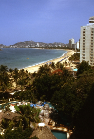
Acapulco, Mexico's first major resort. Photograph by Tony Burton. All rights reserved.

Employment in Mexico is also greatly dependent on tourism. Of the 30 OECD countries, Mexico has the eighth highest figure for the proportion of the workforce in tourism (6.7%), after Spain (13%), Italy (9.7%), New Zealand (9.6%), Hungary (9.2%), Portugal (8.0%), Greece (7.3%) and Japan (6.9%).

Many aspects of tourism are analyzed in detail in chapter 19 of Geo-Mexico: the geography and dynamics of modern Mexico, including:

  • The problems of defining “a tourist”
  • How different kinds of tourism compare in terms of their contribution to Mexico
  • Tourism as a development strategy
  • Spontaneous and purpose-built resorts
  • The concepts of sustainability and ecotourism
  • “Residential tourism”, an unusual category of tourism that is very important in certain specific regions in Mexico.

Map of Baja California Peninsula

 Maps  Comments Off on Map of Baja California Peninsula
Mar 032010
 

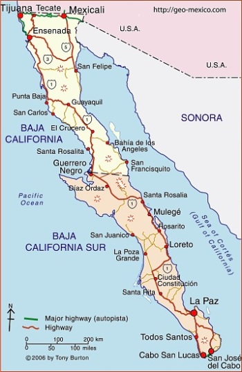
The map shows Mexico’s Baja California Peninsula. This includes the states of Baja California, the northern section of the peninsula, and Baja California Sur. The state capital of Baja California is Mexicali; the state capital of Baja California Sur is La Paz.

Note: There is no such state as Baja California Norte, despite this name being used on some websites!

Click here for the interactive version of this map on MexConnect website

Want to read more?

The development of railways led to tourist guide books

 Other  Comments Off on The development of railways led to tourist guide books
Mar 012010
 

In the golden age of steam, railway lines were built all over Mexico. Rail quickly became THE way to travel. Depending on your status and wealth, you could travel third class, second class or first class. Anyone desiring greater comfort and privacy could add their luxury carriage to a regular train. To avoid mixing with the ordinary folk, the super-rich and the privileged few hired or ran their own special trains.

The railway era ushered in an entire new genre of travel writing, which culminated in the first genuine guidebooks, describing routes and places that other travelers could visit with relative ease. The earliest comprehensive guide to Mexico was Appletons’ Guide to Mexico (1883); it was soon followed by several others including Campbell’s Complete guide and descriptive book of Mexico, first published in 1895.

The 1899 edition of Reau Campbell’s famous Guide provides an idea of what visitors to Cuautla in the state of Morelos, for example, could expect when the train was in its heyday:

Here again the tourist finds another feature of Mexico’s scenery and people, totally different from all the other travels in the Republic. The houses are adobe as to walls and thatched as to roofs; the broad plains have curious trees; bands of Indians troop from one town to another in curious costumes, marching along totally oblivious to the passing locomotive and approaching civilization, and will not give way to the latter any quicker than they will to the engine if they happen to be on the track when it comes along. In fact, it is hard for them to understand that the train cannot “keep to the right” when it meets people in the road, and they claim the right of way from the fact that they were there first.

A decade later, the British-born journalist William English Carson (1870-1940) spent four months in Mexico. Carson also visited Cuautla, on the advice of a doctor as the result of catching influenza.

Upon making inquiries at the railway office about trains to Cuautla, the clerk handed me an illustrated pamphlet with a fine colored picture on the cover representing a Mexican tropical scene. It bore the title, “Cuautla, Mexico’s Carlsbad.” What! I thought, another Carlsbad? In glowing language the booklet described Cuautla as an earthly paradise with a magnificent climate, beautiful scenery, splendidly equipped hotels and a warm sulphur spring whose waters were a certain specific for almost every human ailment. What more could one desire?

Carson continues:

Cuautla is about a hundred miles or so from Puebla, and the speedy trains of the Interoceanic Railway take about ten hours to make the journey. The train which I took left about seven o’clock in the morning ; it was not timed to reach Cuautla until five in the evening; and as there was not any restaurant at any intermediate station, a somewhat terrifying prospect of starvation faced travellers. How were they to get their luncheon? A little pamphlet given away by an American tourist agency and evidently written by an accomplished press-agent gave me the desired information: “At a certain station on the road,” said my traveller’s guide, “your train will stop for some twenty minutes. Here you will be greeted by graceful Indian women,— beauties, many of them, with their olive skins and dark, flashing eyes, bearing themselves with queenly grace in their dainty rebosos and flowing garments, white as the driven snow. They will offer you such dainties as tamales, chili-con-carne and tortillas, piping hot from their little stoves, and prepared with all the scrupulous cleanliness of a Parisian chef. They will bring you dainty refrescos of freshly gathered pineapple or orange to quench your thirst, and pastry such as your mother may have made when her cooking was at its prime.”
Now, what more could any reasonable traveller demand? What need was there for a restaurant when there were all these good things to be enjoyed? I showed my guide to an American friend before I started. He chuckled, gave a knowing wink and remarked, “Great is the faith of man, for after all your experiences you can still believe in a Mexican guide-book.”

Hotels were not always the same standard as those in the USA, but were certainly less expensive:

The attractions of the hotel were hardly up to those of a Carlsbad establishment, for it had neither a writing nor a smoking room; but the terms were rather more attractive than the usual Carlsbad tariff, being about two dollars a day inclusive. It is true there was a good deal of Mexican about the cooking, but the meals were not at all bad and the service very fair…

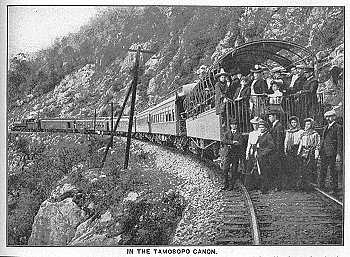
Railways may have opened up Mexico for tourism, but today, sadly, there are virtually no passenger lines still operating, the main exception being the justly famous Copper Canyon line from Los Mochis to Chihuahua.

Sources:
Campbell, Reau. Campbell’s New Revised Complete Guide and Descriptive Book of Mexico. Chicago. 1899.
Carson, William English. Mexico: the wonderland of the south. 1909

This is an edited version of an article originally published on MexConnect.
Click here for the complete article

The growth of the railway network and the importance of railways in Mexico are examined in depth in chapter 17, and tourism in Mexico is the subject of chapter 19. of  Geo-Mexico: the geography and dynamics of modern Mexico.

The geography of cholera in Mexico

 Other  Comments Off on The geography of cholera in Mexico
Feb 282010
 

When Mexico braced herself for the imminent arrival of cholera from South America in 1991, many people believed that the disease had never previously been known here. However, during the 19th century, there were several outbreaks, including the epidemic of 1833 in which more than 3,000 people died in the city of Guadalajara alone.

A meeting of public health officials in January 1833 stressed the need for public areas to be regularly cleaned. This meeting called for the construction of six carts, to be used each night for removing the excrement left on street corners, since not all the houses had “accesorios” (toilets). This proposal reveals the unsanitary conditions which prevailed in Guadalajara at that time.

The epidemic struck in July, and peaked in August, when more than 200 people died of the disease each day. Sporadic cases dragged on into early 1834.

The shout of “Aguas!” (“Waters!”) as a warning of imminent danger, still used in many contexts today, actually dates back to when there was no sewage collection or provision. It was used to warn passers-by in the street below that the contents of “night buckets” were about to be emptied onto their heads…

In 1849 the city of Guadalajara feared a second epidemic. The authorities published a list of precautions that they considered essential, and a list of the “curative methods for Asiatic cholera.” At that time, the only major hospital in the city was the Hospital Belén. Its rival, the San Juan de Díos hospital, was “small and poorly constructed, insufficiently clean, and careless in waste disposal.”

The situation was made worse because  the  San Juan De Díos River was little more than an open sewer running through the center of the city. This river is now entirely enclosed and runs directly beneath the major avenue of “Calzada Independencia.”

Only two methods of sewage disposal were in use in 1850. Some houses took their sewage to the nearest street corner, where it was collected by the nightly cart for subsequent removal from the city. Other (higher class) houses deposited their sewage in open holes in the ground which allowed the wastes to separate, with the liquids permeating into the subsoil and the solids accumulating. Not exactly ideal in terms of public health!

The town council called for the construction of more of these latrines and for the activities of the night carts to be reduced.

The council also advocated increasing the air circulation in the city and simultaneously fumigating it. Authorities in Cuba had tried something similar in 1840, when they had spread resin, and fired batteries of cannons simultaneously, all over Havana! It was believed that the air housed cholera and other diseases and that it could directly affect the organism, through its “miasmas.”

The “Cuban solution” is tried in Guadalajara

In 1850, the epidemic began and the Guadalajara council voted to try the Cuban solution. On August 7th , at the height of the epidemic, fireworks, artillery and everything else were ignited – even the church bells were rung – in order to stimulate air movement and purification , “to increase the electricity in the air and reduce the epidemic.”

During the 1833 epidemic, various industrial plants, including ones making soap, starch and leather, had been closed, though no regulations were ever passed for their subsequent improvement. This time, in 1850, more drastic measures were taken. Tanneries had to construct their own watercourses, and their water was not allowed to collect and stagnate by bridges. Soap works were transferred out of the city completely. Despite these efforts, many stagnant pools of water would have lain on the city’s poorly constructed cobblestone streets: pools of water just waiting for an outbreak of cholera.

The police force was given the power to supervise everyone’s adherence to the regulations. Inspectors were appointed for each district or barrio to see that all “night activities” (carts included) terminated before 8:00 a.m., that sewage water was not used for the irrigation of plants, that gatherings were not too large, and that billiard, lottery and society halls all closed at the start of evening prayers.

A group of doctors was obliged to give its services free to anyone who needed medical help. The doctors apportioned the city among themselves and were told by the town council that they would be paid for their services as soon as council funds permitted. The main idea, of course, was to help the poor, perhaps not so much from any altruistic motives but to avoid any inconvenience to the rich!

Fortunately, any new outbreak of the disease in modern Guadalajara will be handled very differently to these 19th century epidemics. The excellent modern medical facilities in the city, and the large number of qualified doctors, mean that anyone unlucky enough to contract the disease should be able to get adequate treatment ensuring a full and speedy recovery.

This is an edited version of an article originally published on MexConnect

Click here for the complete article

Note: The diffusion of cholera in Mexico during the 1991-1996 epidemic is discussed, alongside a map showing the incidence of the disease, in chapter18 of Geo-Mexico: the geography and dynamics of modern Mexico.

Geo-Mexico also includes an analysis of the pattern of HIV-AIDS in Mexico, and of the significance of diabetes in Mexico.

Mexico’s top yachtsman wins the first round-the-world yacht race.

 Other  Comments Off on Mexico’s top yachtsman wins the first round-the-world yacht race.
Feb 272010
 

The first Whitbread Round-The-World yacht race was won by a Mexican.

Most people do not associate Mexico and Mexicans with yachting, but it’s a fact that the first Whitbread Round-The-World Yacht Race, in 1973-4, was won by the Mexican ketch Sayula II, skippered by Ramón Carlin, a Mexican businessman who made his money from washing machines.

What makes Carlin’s achievement all the more remarkable is that relatively few of Mexico’s 108 million inhabitants actually reside on the coast, even though the country is sandwiched between the Gulf of Mexico and the Pacific Ocean and actually has a long coastline. Most large Mexican cities are located in the interior. The nation’s capital, Mexico City, is unusual in being one of the very few major cities in the world not situated on the sea.

Not surprisingly, then, when Carlin set out with Sayula II from Portsmouth, England, alongside 16 other yachts, in September 1973, the pundits did not give him any chance of victory. Most of the yachts in the race were European, and Europeans have completely dominated the race ever since. But Carlin, with his crew of 12 (including family, friends and some professional sailors from other countries) sailed off in their production line Swan 65 determined to do their best.

And their best proved very good indeed. The 1973-4 race had four legs. Taking handicap into account, Sayula II came second in the first leg, Portsmouth to Cape Town, and then won the second leg, Cape Town to Sydney. This was a particularly remarkable achievement since this leg proved to be the hardest in the entire race, exposing all the competitors to unbelievably adverse weather in the Southern or Indian Ocean. Violent storms and 40-knot winds battered all the contestants and two yachts were forced to abandon the race. Sayula II capsized. Her cabin was filled with water and most of her crew, fortunately securely tethered, were swept overboard, sustaining numerous minor injuries. But the ketch survived and the crew soon had her under way again.

From Sydney, the race took the yachts across the Pacific and round Cape Horn. Prior to the race, less than 10 private sports yachts had ever rounded Cape Horn successfully. It should also be remembered that Sayula II didn’t have the benefit of the thousands of dollars worth of modern navigational equipment, including GPS systems and transmitters for audio and video satellite communications, now considered standard on racing yachts.

For the Sydney-Rio de Janeiro leg Sayula II came second, on handicap, and then placed fourth (on handicap) for the final leg across the Atlantic to Portsmouth. Carlin sailed the yacht across the finish line on April 9, 1974, and was declared the overall winner. Sayula II had taken 152 days (133 days on corrected time) to sail 32,500 nautical miles (about 60,000 kilometers).

And, how did Carlin celebrate his unexpected victory? Well, in time-honored Mexican tradition, he donned a mariachi’s sombrero and partied, partied, partied!

Source: The main inspiration and source for this article was “Sayula pusó la muestra” published on page 7 of the Guadalajara daily Público on July 26, 2001.

This is an edited version of an article originally published on MexConnect.

Click here for the complete article

Tourism in Mexico, including yachts and marinas, is discussed in chapter19 of Geo-Mexico: the geography and dynamics of modern Mexico.]

Mexico has the world’s 11th largest economy

 Other  Comments Off on Mexico has the world’s 11th largest economy
Feb 242010
 

These are the world’s 14 largest economies (GDP, purchasing power parity, 2008, in US dollars):

  1. USA           14,960 billion
  2. China         7,800 billion
  3. Japan         4,487 billion
  4. India           3,319 billion
  5. Germany     2,863 billion
  6. UK             2,279 billion
  7. Russia       2,225 billion
  8. France       2,097 billion
  9. Brazil         2,030 billion
  10. Italy           1,801 billion
  11. Mexico       1,578 billion
  12. Spain         1,378 billion
  13. Canada       1,336 billion
  14. South Korea   1,312 billion

As you can see, Mexico has the world’s 11th largest economy, slightly larger than the economies of either Canada or Spain.

[Figures taken from Table 14.1 of Geo-Mexico: the geography and dynamics of modern Mexico.]

Review by John Pint in MexConnect

 Reviews of Geo-Mexico  Comments Off on Review by John Pint in MexConnect
Feb 232010
 

John Pint, one of Mexico’s best known cavers and explorers, and author of “Outdoors in Western Mexico”,  has reviewed Geo-Mexico: the geography and dynamics of modern Mexico for MexConnect e-zine.

In Pint’s view,

Rhoda and Burton tell us that geography as a subject is — like Mexico itself — “often under-appreciated, equated with memorizing the names of countries, capitals, mountain ranges and rivers.” However, these authors claim that “real” geography is much more interesting and even exciting because it “focuses on the interaction between individuals, societies and the physical environment in both time and space.”

This book, in fact, includes subjects like female quality of life in Mexico, access to cell phones, urban sprawl, the survival of the Tarahumara Indians and even gives us the touring route of the Hermanos Vázquez Circus.

Pint concludes that

Geo-Mexico will surely become the geography book of choice for ethnically-oriented courses in the USA and Canada…  If only we’d had textbooks like this one when I was a youngster.

Click here for the complete review by John Pint

Feb 222010
 

Mexicans have a long history of working and living in the USA. Migration is one of the most important linkages between North America’s two most populous countries. The Mexican diaspora in the USA is an integral part of both Mexican and US society. Each year roughly 250 million legal border crossings are made, about half by Mexicans. A much smaller number, perhaps a few hundred thousand, cross the border illegally despite US efforts to tighten border controls. The Mexican communities on either side of the border are very closely linked.

Mexicans in the USA
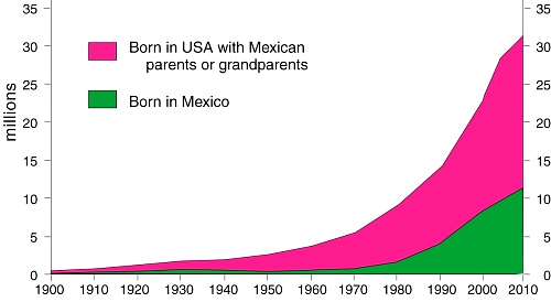
As of 2008 over 31 million Mexicans lived in the USA (see graph). This is more than one fifth of all Mexicans anywhere and a larger number than in any single Mexican state. Almost 19 million Mexican-Americans were born in the USA of Mexican parentage; these have always outnumbered migrants.

Roughly 10% of everyone born in Mexico now lives in the USA. This figure was only 5% as recently as 1990 and only 1.4% in 1970. Migrating Mexicans are as likely to move to the USA as within Mexico. Clearly, in recent decades, an increasing number of Mexicans have chosen to live in the USA.

[Extract from chapter 27 of Geo-Mexico: the geography and dynamics of modern Mexico]

A brief history of geography in Mexico

 Other  Comments Off on A brief history of geography in Mexico
Feb 192010
 

Mexico has a long tradition of geography. Modern geography was given a jump-start in the country by the brilliant Prussian traveler Alexander von Humboldt, who explored Mexico for twelve months in 1803–04.

The Mexican Society of Geography and Statistics was founded in 1833, only three years after the UK’s Royal Geographical Society and fully 55 years before the National Geographic Society. Geography remains a popular and respected subject in Mexican high schools and universities.

Even prior to Humboldt, many authors had made valuable descriptions of many aspects of Mexico’s geography. Writing in the mid-17th century, but looking back to a century earlier, Father Antonio Tello, in describing the province of Xalisco (Jalisco) offers lots of information about plants, animals, natural hazards, rivers and natural hot springs, while speculating about whether underwater springs fed Lake Chapala, Mexico’s largest natural lake.

Though many volumes have been lost, the surviving parts of the Geographic Accounts written at the end of the 16th century are a veritable “Domesday Book” of information.

After Humboldt, however, geography set off on a much more scientific, analytical path, one which has continued to the present day and which has now resulted in Richard Rhoda and Tony Burton’s Geo-Mexico: the geography and dynamics of modern Mexico.

Mexico’s Spanish language place names

 Teaching ideas  Comments Off on Mexico’s Spanish language place names
Feb 182010
 

The Spanish language is at least as rich as English when describing landscapes. Common Spanish geographical terms relating to landscape include:

  • cerro = hill
  • montaña = mountain
  • sierra = elongated mountain range
  • mesa = flat-topped (table) hill
  • cumbre = summit or peak
  • pico = sharp peak
  • valle = valley
  • barranca = canyon
  • cenote = limestone sinkhole
  • cabo = point or cape
  • punta = point or headland
  • arroyo = brook
  • río = river
  • lago = lake
  • salto, cascada = waterfall
  • ojo (de agua) = spring
  • presa = reservoir (and dam)
  • mar = sea
  • salinas = salt flats or salt works
  • golfo = gulf
  • bahía = bay
  • puerto = port (inland, puerto = pass)

[Extract from chapter 1 of Geo-Mexico: the geography and dynamics of modern Mexico]

Mexico’s indigenous place names

 Teaching ideas  Comments Off on Mexico’s indigenous place names
Feb 172010
 

Mexico’s place names, or toponyms, offer many clues about geography. Mexico’s indigenous peoples spoke languages that had no formal alphabet. For place names, they used combinations of pictographs, ideographs and phonetic symbols.

Spanish explorers recorded the names provided by the locals as best they could, resulting in some inevitable confusion and distortion. For instance, it is sometimes claimed that “Yucatán” actually derives from Maya Indians responding, “I don’t know!” when asked to name a nearby place.

Suffixes derived from indigenous (mostly Nahuatl) words include:

  • -apan = in/near water or river
  • -calco = in the house of
  • -can = place
  • -cingo, -tzingo = (small) place of settlement
  • – huacan, -oacan = place where they have
  • -pan = in/on
  • -ro = place
  • -tepec = hill
  • -tepetl = mountain
  • -titlan = near
  • -tla = abundance
  • -tlan = in or near

Can you think of examples of modern-day place names using each of these suffixes? For instance,  “Zapopan”, in the state of Jalisco, is an example of a place name ending in -pan = in/on.

[Edited extract from chapter 1 of Geo-Mexico: the geography and dynamics of modern Mexico]

Mexico’s ecological footprint compared to that of other countries

 Other  Comments Off on Mexico’s ecological footprint compared to that of other countries
Feb 162010
 

The ecological footprint of a country  is defined as the area of land (and water) required by a population, given prevailing technology, to produce the resources it consumes and to absorb any wastes created.

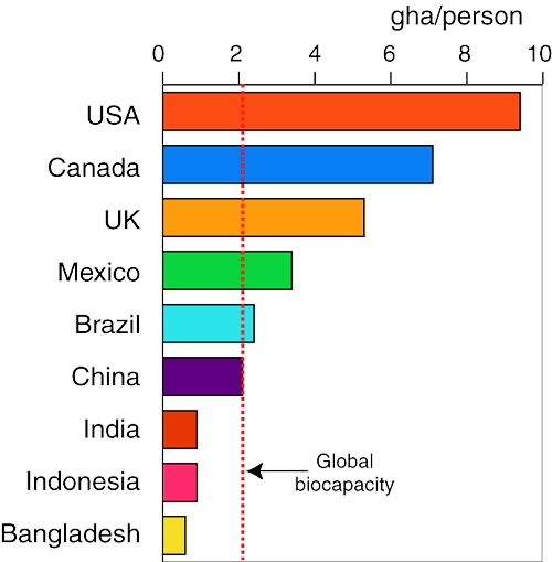
Ecological footprints are measured in ‘global hectares’ (gha). A global hectare encompasses the average annual productivity of all biologically productive land and ocean areas in the world. In 2005 the world’s population required the resources of 2.7 gha /person.  Unfortunately, the world’s biocapacity—the amount of resources its ecosystems can supply each year—was only equivalent to 2.1 gha per person and is declining each year as population increases (see graph).

The deficit between biocapacity and our ecological footprint causes damaging environmental changes to forests, fisheries, rivers, coral reefs, soil, water and air, and plays a major role in global climate change. The figures mean that our current usage of the world’s resources is inherently unsustainable.

Click here for a printable bookmark of this graph (pdf file)

The graph shows the ecological footprint of several countries. China’s footprint matches global biocapacity while the footprints of India, Indonesia and Bangladesh are fully sustainable. On the other hand, the USA’s footprint of 9.4 gha is surpassed only by the United Arab Emirates. Australia and Canada both have footprints over 7 gha. In simple terms, their populations require more than three times their fair share of the world’s biocapacity.

Chapter 30 of Geo-Mexico: the geography and dynamics of modern Mexico, from which this extract is taken, looks in much more detail at the implications of ecological footprints and at alternative ways of assessing ‘sustainability’.

Giant whirlpool swallows several boats in 1896

 Other  Comments Off on Giant whirlpool swallows several boats in 1896
Feb 152010
 

An anonymous writer in the Los Angeles Times edition of 13 January 1896, reported on a strange and terrifying happening that struck the western part of Lake Chapala (Mexico’s largest natural lake)…

Startling Spectacle at Lake Chapala.

  • Its Waters Swallowed by a Subterranean Cave.
  • Several Pleasure Boats and Their Occupants Engulfed.

SAN DIEGO, Jan. 12.—(Special dispatch.) Prof. E. H. Coffey of this city, has just received a letter from a correspondent. living near Lake Chapala, State of Jalisco, Mex.. which describes some startling phenomena occurring. Lake Chapala is a sheet of water fifty miles long and ten miles wide. The formation of the country around it is purely volcanic.

On the forenoon of January 8 residents in one of the small settlements near the western end of the lake were terrified to see a gigantic whirlpool raging far out on the water. The waters rose in great serpentine movements, and from all directions rushed toward a common center, where a vast cavity seemed to exist. At the same time a heavy, rumbling sound, apparently in the bowels of the earth, took place. The whirlpool was caused by the sudden sinking of a large portion of the lake’s bottom, and before the disturbance subsided several pleasure-boats were drawn into the whirlpool and disappeared with their occupants. It is estimated that a score of lives were lost.

The whirlpool continued for nearly twenty minutes, and when the inhabitants of the surrounding territory turned their eyes from the overwhelming sight they saw that the lake had receded several feet from its former shore line. As the lake is about fifty miles in length, with an average width of ten miles, the enormous amount of water that was swallowed up by the earth may be imagined. After the whirlpool subsided the surface of the lake resumed its placid aspect, and the subterranean rumblings ceased.

There was the greatest excitement among the people for miles in the vicinity of the western end of the lake, the most ignorant and superstitious natives being beside themselves with fear. Years of familiarity with volcanic eruptions and terrestial disturbances did not seem to reassure them during this dreadful experience.

[This post is an edited extract from Lake Chapala Through the Ages, an anthology of traveller’s tales]

Natural hazards in Mexico are discussed in detail in chapters 2, 4 and 7 of Geo-Mexico: the geography and dynamics of modern Mexico.

One of Mexico’s earliest geographers

 Other  Comments Off on One of Mexico’s earliest geographers
Feb 142010
 

José Antonio Villa-Señor y Sanchez, born in Mexico in about 1700, is one of the earliest Mexican geographers. He studied at the College of San Idelfonso in Mexico City, and was later employed in the collection of taxes, becoming comptroller of revenue from mercury (a chemical essential to the refining of silver ores).

He was subsequently appointed cosmographer of New Spain. In this capacity in 1742, he was commissioned by the Viceroy, Pedro de Cebrián y Agustín, Count of Fuenclara, to write a descriptive history and geography to comply with a royal edict from King Philip V of Spain. His works included Teatro Mexicano; Descripción general de los Reinos y Provincias de la Nueva España (1746), Observación del Cometa, que apareció en el hemisferio de México en Febrero y Marzo (1742) and several maps, including one of the Jesuit province of New Spain, from Honduras to California (1754). He died in about 1760.

More than 200 years later, the planners of Ciudad Satélite, an urban development in the northern part of Mexico City, named a street in the Circuito Geógrafos area after him.

Villa-Señor’s descriptions help to paint a wonderful picture of what New Spain was like in the middle of the 18th century. For instance, he describes the city of Guadalajara as having eight plazas; fourteen churches, monasteries and convents; two colleges and a university; two hospitals and a dozen government buildings or public facilities, making it a fine, surprisingly spacious and prosperous city.

Villa-Señor y Sanchez provides us with our earliest description of the marshy areas at the south-east corner of Lake Chapala, which at that time had several small islands. This is the area that was deliberately drained in the early years of the 20th century. The former islands are now visible only as small hills protruding above flat, intensively cultivated farmland.

[This post is an edited extract from Lake Chapala Through the Ages, an anthology of traveller’s tales]

Lake Chapala’s remaining wetlands were recently (4 February 2009) granted Ramsar Protection Status.

To read more about the issues facing Lake Chapala, Mexico’s largest natural lake, see chapters 6, 7 and 19 of Geo-Mexico: the geography and dynamics of modern Mexico.

For more background to Lake Chapala’s issues, read Tony Burton’s series on MexConnect or use that site’s search function.

Feb 132010
 

Mexico’s mass tourism industry in the past forty years has been dominated by large-scale, purpose-built developments partially funded by federal funds. In 1967, responding to bullish predictions of US demand for beach vacations,  Mexico’s central bank identified the five best places for completely new, purpose-built tourist resorts. Top of the list, as part of a 30-year plan, was the uninhabited barrier island now known as Cancún. The other choice locations were Ixtapa, Los Cabos, Loreto and Huatulco.

The National Fund for Tourism Infrastructure (renamed the National Tourism Development Fund, Fonatur, in 1974) began building Cancún in 1970 and Ixtapa in 1971.

Cancún has become Mexico’s foremost tourist resort. Factors considered in the choice of Cancún included water temperatures, the quality of beaches, varied attractions, sunshine hours and travel distances from the main markets. The stated benefits were thousands of new jobs, increased revenues, the development of a previously peripheral region and the diversification of the national economy.

Public funds were used to purchase land, improve it by fumigation and drainage, and install all necessary basic infrastructure (airport, highways, potable water, electricity, telephone lines, convention center, golf course, harbors). Private sector investors developed hotels, a shopping center and supporting services.

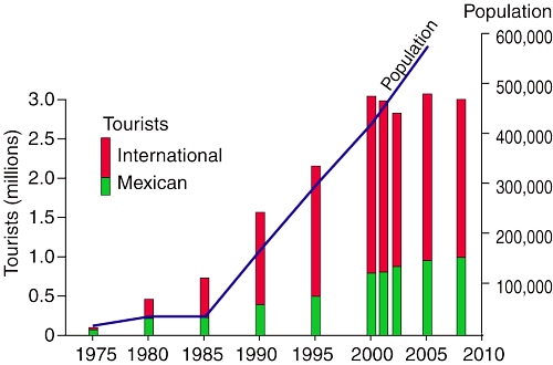
By 1975, Cancún had 1769 rooms in service; by 2008, it boasted about 150 hotels and more than 27,000 rooms. Second only to Mexico City, Cancún airport now handles 200 flights a day. The influx of people to Cancún has been especially dramatic. The city has had to cope with unprecedented growth rates as its population shot up from 30,000 in 1980 to 676,238 in 2010 (preliminary census figure) (see graph).

The number of tourists in Cancún dipped slightly in 2001–2002 due, in part, to the 2001 9/11 tragedy in the USA. Hurricane Wilma (2005) put many hotel rooms temporarily out of commission. Cancún is now only one focus of an extensive tourist corridor along the Quintana Roo coast, stretching as far south as Tulum.

Chapter 19 of Geo-Mexico: the geography and dynamics of modern Mexico, from which this extract is taken, looks in much more detail at Mexico’s purpose-built resorts as well as many other  aspects of tourism, resorts and hotels  in Mexico.

The Aztecs knew their geography!

 Other  Comments Off on The Aztecs knew their geography!
Feb 122010
 

Aztec place glyphs drawn in the 16th century Codex Mendoza suggest that the Aztecs had all the major branches of geography covered.

Physical geography

Poctépec = hill that smokes (volcano)

Human geography

Teocalcingo = where the temple is

Economic geography


Michmaloyan = place to fish

The Aztecs clearly knew their geography!

[Extract from chapter 1 of Geo-Mexico: the geography and dynamics of modern Mexico]

The geography of Mexican cuisine

 Other  Comments Off on The geography of Mexican cuisine
Feb 102010
 

Mexican cuisine is extraordinarily varied and has become one of the most popular in the world. Diana Kennedy, the foremost authority on the subject, has devoted her life to researching the regional variations in ingredients, cooking methods and typical local dishes.

The ingredients used reflect different climates and ecosystems (see Geo-Mexico chapters 4 and 5). For instance, corn (maize) tortillas predominate in southern and central Mexico while wheat tortillas are more commonly found in the north of the country.

Pork and hominy stew (pozole) is largely restricted to the Pacific coast states of Jalisco and Guerrero. The grilled beef of cattle ranges in the northern interior of Mexico contrasts with the seafood found along the coast.

Cuisines are strongly influenced by trade routes and migration, especially the arrival of immigrant groups. Mexican cuisine is a fusion of  ndigenous and Spanish cooking, influenced in some regions by Cuban, Italian, French and other migrants.

On a more local scale, miners from Cornwall in the UK who came to work in the silver mines of Real del Monte in the state of Hidalgo brought with them their meat and vegetable-filled pastries called Cornish pasties. These were quickly assimilated into the local cuisine, and pastis, admittedly with some chilies added, are still sold in the town.

[Note: This post is an edited extract from chapter 13 of Geo-Mexico]

For more about Mexican cuisine, visit the amazing award-winning blog Mexico Cooks! and also browse the huge selection of recipes, articles and tips about all aspects of Mexican food and cooking in the “Cuisine” section of MexConnect. ¡Buen provecho!

Mexico’s population in 1990, 2010 and 2050

 Books and resources, Teaching ideas, Updates to Geo-Mexico  Comments Off on Mexico’s population in 1990, 2010 and 2050
Feb 082010
 

Want your very own Geo-Mexico bookmark?

This link – Population of Mexico in 1990, 2010 and 2050 – is to a pdf file of three age-sex pyramids showing the population of Mexico in the years 1990 and 2010, and the predicted population for the year 2050.

Print the file to make your own Geo-Mexico bookmark and get a fascinating insight into Mexico’s likely future population. Mexico’s population growth rate has fallen dramatically since 1990. More surprisingly, between now and 2050, the average age of people in Mexico will rise rapidly. Mexico is set to move from a predominately young population to a predominately old population in only a couple of generations.

What else can you say about Mexico’s population from a close analysis of the population pyramids? (Feel free to post your comments below)

Mexico Bible for Armchair Explorers of Geography and More

 Reviews of Geo-Mexico  Comments Off on Mexico Bible for Armchair Explorers of Geography and More
Feb 072010
 

Review by Dale Palfrey in The Guadalajara Reporter, Friday January 22, 2010. (Reproduced by kind permission of The Guadalajara Reporter)

Collaborating long-distance via Internet over the past six years, Tony Burton and Richard Rhoda have put together the most comprehensive resource of Mexico geography ever published. “Geo-Mexico, the Geography and Dynamics of Modern Mexico” is now on the market in sync with a milestone year in the country’s history.

Mexico is home to planet earth’s largest natural crystals, its deepest water-filed sink hole, and second richest man, telecommunications magnate Carlos Slim. The country ranks first in the world for diversity of reptile species and the incidence of diabetes, while placing second only to the United States in the consumption of soft drinks. Those are just a few of the juicy factual tidbits curious readers will pick up on the pages of the timely and engaging tome compiled by Ajijic-based geographer Richard Rhoda and colleague Tony Burton, a former lakeside resident who now makes his home in Ladysmith, British Columbia.

The book goes far beyond describing the physical characteristics of the country, exploring sociological, economic, political and cultural landscapes as well to comprise the most comprehensive geographical study of the republic ever published in English.

Laymen and scholars alike will appreciate the straightforward, seamless, reader-friendly writing style and the enhancement of information with more than 150 maps, graphs, diagrams and highlighted textboxes. Presented in 31 easily digestible chapters, the text delves into tha land’s past, present and future with keen analysis that provides a clear understanding of Mexico in a global context.

The concept for the book originated from a lecture series on Mexican geography Rhoda put together for the Lake Chapala Society in 2004. From his original idea of putting his lecture notes into a printed form, the project evolved into a six year research, writing and publishing endeavor.

Burton’s involvement came about as Rhoda was looking into avenues for getting his work into print. He pulled a copy of Burton’s “Western Mexico: A Traveller’s Treasury” off his bookshelf and learned that the self-published author was a fellow geographer. He contacted Burton to seek advice on how to get the work published, but finding common ground, soon saw the project turn into a collaborative effort.

It turns out that Burton had a similar idea floating in the back of his head that came from his struggles to find a single, solid resource in the early 1980’s when he was teaching a college level course on subject in Mexico City. Frustrated by the need to assemble teaching materials from diverse sources, he yearned to fill the gap, but saw it as a gargantuan task he could only conceive of undertaking in retirement.

After an initial exchange of ideas, the two men promptly developed an easy-going working relationship, complementing one another perfectly in their divergent areas of expertise. Rhoda wrote a first draft and then Burton kicked in on editing, fleshing out the content, and putting together the graphics.

The end product is a stunning accomplishment, intentionally timed to coincide with Mexico’s Independence bicentenary and Revolution centenary milestone. It is a must-have item for any Mexicophile’s bookcase.

Oil exports to USA

 Updates to Geo-Mexico  Comments Off on Oil exports to USA
Feb 062010
 

According to the US Department of Commerce, Mexico overtook Saudi Arabia to become the third largest oil exporter to the USA in 2009, behind Canada and Venezuela. Mexico’s exports of crude to the USA last year totaled almost 380 million barrels.
Mexico had been the second largest exporter of oil to the USA in 2007, but fell back to fourth in 2008.

 Tagged with:
Feb 022010
 

This link is to a blank outline map of Mexico (in pdf format), including state boundaries, but no cities or other features.

Blank outline map of Mexico

There are no restrictions on how this map may be used (no royalty is payable) but please credit geo-mexico.com if you download and use it in any report or in class.

We welcome comments on whether or not you found this map useful.
Please use the comments form if you wish to tell us about other maps that you would like to see on our site.

Chapter titles of Geo-Mexico

 Other  Comments Off on Chapter titles of Geo-Mexico
Jan 272010
 

Geo-Mexico has 31 chapters:
 1 The dynamics of Mexican geography
2 Earthquakes and volcanoes
3 Relief and landforms
4 Land of diverse climates
5 Ecosystems and biodiversity
6 Water availability, rivers and aquifers
7 Water issues and hazards
8 Population decline, followed by population explosion
9 The dynamics of population growth
10 Indigenous peoples
11 The geography of religion
12 The changing political map of Mexico
13 Mexico’s cultural landscape
14 Economic activity: is Mexico a world player?
15 Agriculture, forestry, fishing, mining
16 Manufacturing, construction and services
17 Transportation: the movement of people and goods
18 Communications: the movement of information and ideas
19 Tourism and development
20 Mexico and the world economy
21 500-year transition to an urban society
22 The internal geography of Mexico’s cities
23 Urban issues, problems and trends
24 Rural Mexico and rural-urban interactions
25 Migration within Mexico
26 Migration to the USA
27 Mexicans in the USA
28 Quality of life in Mexico compared to other countries
29 Variations in quality of life within Mexico
30 Environmental trends and issues
31 What does the future hold?

Basic facts about Mexico

 Updates to Geo-Mexico  Comments Off on Basic facts about Mexico
Jan 222010
 

Area = 1,964,375 sq. km (758,449 sq. miles) World rank: 14
Population, 2008: 106,682,518 World rank: 11
Economy: GDP (PPP*), 2008: US$1.58 trillion World rank: 11
GDP per person, 2008: US$14,810 World rank: 70+
Length of coastline 11,122 km (6911 miles) World rank: 14
Highest point: Pico de Orizaba 5610 m (18,406 ft) World rank: na
*PPP = purchasing power parity
[Source: Table 1.1 of “Geo-Mexico, the geography and dynamics of modern Mexico.”]

Canadian Club of Ajijic listens to Geo-Mexico co-author

 Other  Comments Off on Canadian Club of Ajijic listens to Geo-Mexico co-author
Jan 152010
 

More than 300 people packed the grounds of La Nueva Posada hotel in Ajijic, Mexico, to hear Geo-Mexico co-author Tony Burton talk about the significance of 2010 in Mexico. Burton took an historical approach, exploring both the history of geography and the geography of history while comparing many aspects of Mexico in 1810 (Independence), 1910 (Revolution) and 2010. His entertaining and informative talk, which was largely based on material in Geo-Mexico, was well received.
At the end of his talk, Burton highlighted the fact that Mexico’s population projections for 2050 suggest that the country will have moved from a predominately young to an elderly population in only one or two generations.

Geo-Mexico talk in ACÁ eco-series

 Other  Comments Off on Geo-Mexico talk in ACÁ eco-series
Jan 112010
 

UPDATE – This post has been edited to reflect the fact that ACÁ closed in mid-2011.

Geo-Mexico author Tony Burton, aided by Richard Rhoda, gave a presentation today about “Man and Nature in Mexico” as a fund-raiser to a good-sized group of ACÁ supporters.
ACÁ was a non-profit organization in Mexico that promoted sustainable farming and resource use, and had made a considerable positive impact on hundreds of villagers in the Lake Chapala region of Jalisco. The talk was well received and some great questions were asked, which we will try to answer more fully in future posts on this blog. They included a request for more details about the highly productive chinampa system of food production which dates back to pre-Hispanic times. Watch this space for more details in the near future!