Search Results : jalisco

Fresnillo, Mexico’s leading silver mining town

 Other  Comments Off on Fresnillo, Mexico’s leading silver mining town
Aug 242013
 

The city of Fresnillo, founded in the sixteenth century, is a place that most people speed by en route to somewhere else. Yet Fresnillo, in the state of Zacatecas, holds several surprises. It was once an important city on the colonial silver route (El Camino Real or Royal Road, the spine of the colonial road system in New Spain), and still boasts many fine buildings, including a lovely old theater and several churches.

fresnillo-plcFresnillo is still an important mining center today. Fresnillo plc, incorporated in the UK, is Mexico’s largest single silver mining company and the country’s second largest gold producer. It operates mines in three major mining zones in Mexico—Fresnillo (Zacatecas), Ciénega (Durango) and Herradura (Sonora)—and is actively developing or exploring numerous other sites.

Fresnillo became a major mining center from 1568, when a garrison of soldiers, complete with a fort, was installed in the town to help protect mule-trains carrying silver from Sombrerete (and the San Martín mine) further north and Zacatecas. By the mid-nineteenth century, Fresnillo’s own mines had serious flooding problems. Mine owners sent to England for experienced Cornish tin miners to come and help. The Cornishmen knew how to assemble and operate powerful steam engines, a novelty at that time in Mexico, and a reliable way to help drain deeper mine shafts.

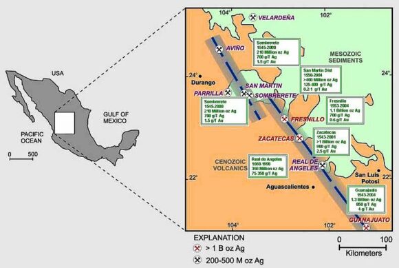
Location of mining districts near Fresnillo. Credit: 321gold.com

Location of mining districts near Fresnillo. Credit: 321gold.com. Click to enlarge

George Ruxton, a nineteenth century traveler and author, described Fresnillo when he visited as “paltry” but “busy and frenzied” with 2500 miners hacking away at the nearby mountains. Ruxton thought the work ethic of the Cornish was superior to other English settlers and to the local Mexicans. He was especially impressed by how the miners had planted a beautiful garden, full of fruit-bearing trees, complete with a fountain and ornamental summerhouse.

Silver bars were regularly taken from Fresnillo to Zacatecas for smelting and subsequent stamping in the Zacatecas mint. The wagon-trains carrying silver bars, called conductas while under military protection, were frequently assaulted by large groups of bandits, up to several hundred strong.

Fresnillo also has significant artistic interest. Two very famous, yet very different, Mexican artists—musician Manuel M. Ponce and painter Francisco Goitia—were born in (or at least very near) the city in the same year, 1882.

The patron saint of silversmiths

From Fresnillo, it is only seven kilometers along a wide, well-paved road to Plateros, a place of pilgrimage. The baroque Santuario de Plateros was built at the end of the eighteenth century to be a suitable residence for the Santo Niño de Atocha and the Señor de Plateros (the patron saint of silversmiths). The fame of the Santo Niño de Antocha spread rapidly following a fight between two miners. One miner was sure he had killed the other but then prayed to this saint for his recovery. Lo and behold, his companion recovered! Ex-votos (retablos) tell the stories of the numerous “miraculous” interventions performed by the Santo Niño de Antocha to resolve all manner of problems in more recent years.

Source: Most of this post is based on chapter 20 of my “Western Mexico: A Traveler’s Treasury” (link is to Amazon’s “Look Inside” feature), also available as either a Kindle edition or Kobo ebook.

Other Mexican mining towns previously described on Geo-Mexico.com include:

The volcanic calderas of Mexico’s Volcanic Axis

 Maps, Other  Comments Off on The volcanic calderas of Mexico’s Volcanic Axis
Jul 082013
 

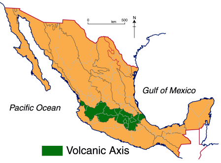
There is still lots of work needed to fully unravel the geological secrets of Mexico’s Volcanic Axis which crosses the country between latitudes 19̊ and 21̊ North. Unlike most volcanic belts elsewhere in the world, this one does not appear at first sight to correspond to any plate boundary. Another of the mysteries of this volcanic region, where igneous upheavals have shaped the landscape for several million years, is the relative dearth of calderas, the “super craters” formed either by collapse or by giant explosions.

While the toponym La Caldera is used fairly commonly in Mexico’s volcanic regions for a volcano or volcanic crater, geologists restrict the term to the much larger landform that results from the collapse or super-explosion of a volcano. Even so, there is still some debate among specialists as to the precise definition of the term caldera.

Geologists have proposed a threefold division of the Volcanic Axis, based on differences in the volcanic landforms, in terms of their type, structure, age, morphology and chemistry.

volcanic-axis

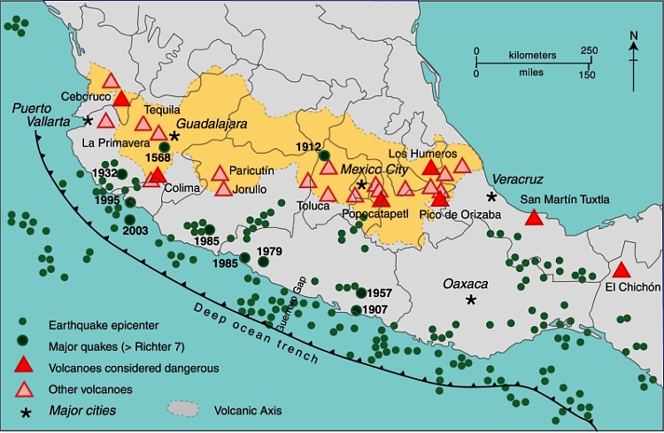
The western sector (see map below) extends from the western coast of Mexico to Lake Chapala (including the lake basin). The central sector covers the area between Lake Chapala and the twin volcanoes of Popocatepetl and Ixtaccihuatl, close to Mexico City. The eastern sector includes these twin volcanoes and extends as far as Mexico’s Gulf Coast.

Mexico's Volcanic Axis (Fig 2.2 of Geo-Mexico, the geography and dynamics of modern Mexico. All rights reserved.

Mexico’s Volcanic Axis (Fig 2.2 of Geo-Mexico, the geography and dynamics of modern Mexico). All rights reserved.

The only caldera recognized in the western section is that of La Primavera, the forested area west of Guadalajara, whose formation we considered in

In the central and eastern sections of the Volcanic Axis, several other calderas have been recognized. They include (from west to east):

  • Los Azufres
  • Amealco
  • Mazahua
  • Huichapan
  • Los Humeros
  • Las Cumbres

Los Azufres

The precise origin of the Los Azufres caldera, in Michoacán, is still debated. The caldera is the site of an important geothermal power station with an installed capacity of 188 MW. (Mexico is the world’s fourth largest producer of geothermal energy, after USA, the Philippines and Indonesia.) The geothermal heat in this area is also used to heat the cabins in a local campground, and to dry wood and process fruit.

Amealco

The Amealco caldera is in the central part of the Mexican Volcanic Axis, midway between the towns of San Juan del Río and Maravatio. It dates from Pliocene times and has been heavily eroded since. It is about 11 km wide and 400 m deep and was the origin of great sheets of pyroclastic flow deposits (ignimbrites) with a total volume of around 500 cubic km.

Mazahua

Mazahua is a collapse caldera, 8 km in width, near the village of San Felipe del Progreso in the western part of the State of Mexico.

Huichapan

The Donguinyó-Huichapan caldera complex is 10 km in diameter and in the central sector of the Volcanic Axis. It appears to be two overlapping calderas, dating from around 5 million and 4.2 million years ago respectively. The rocks from the older caldera are intermediate to basic in composition, while those from the more recent caldera are acidic (high silica) rhyolites.

Los Humeros

The Los Humeros caldera is in the state of Puebla, close to its border with Veracruz. It is 55 km west-north-west of the city of Xalapa (Veracruz), relatively close to Teziutlán (Puebla). The main caldera (summit elevation 3150 m) is about 400 m deep and roughly oval in shape, with a diameter which varies from 15 to 21 km. It was formed about 460,000 years ago by the collapse of the underground magma chamber. Prior to collapse, lava emitted from this vent had covered 3500 square km with ignimbrite. Later, two smaller calderas formed nearby, with ages of about 100,000 years (Los Potreros caldera) and 30,000 years (El Xalapazco) respectively. Volcanic activity in this area has been utilized to produce generate geothermal power (installed capacity: 40 megawatts).

Las Cumbres

The easternmost caldera in Mexico is Las Cumbres, 15 km north of Pico de Orizaba, Mexico’s highest volcano, and close to the state boundary between Puebla and Veracruz. The Las Cumbres caldera was originally believed to be an explosion super-crater, but geologists now think that it was created due to the partial collapse of the eastern flank of the original volcano, between 40,000 and 350,000 years ago. The collapse of the side of Las Cumbres produced a huge debris avalanche (total volume estimated at 80 cubic km, which extended up to 120 km in the direction of the Gulf of Mexico.

Lake Alchichica

According to Dra. Esperanza Yarza de la Torre in Volcanes de México (UNAM; 1984), Lake Alchichica in the Oriental Basin near Puebla occupies another caldera. The basin has several shallow lakes, known locally as axalpazcos (“sandy basin with water” in the indigenous Nahuatl language). These occupy shallow craters (or in one case a caldera) and are largely sustained by ground water. The largest of the lakes, in a caldera, is Lake Alchichica, which has a diameter of 1888 meters, an area of 1.81 square km, and lies at an elevation of 2320 meters above sea level. The rim of the caldera rises 100 m above the lake level. The lake is used for irrigation. This lake is claimed to be Mexico’s deepest natural lake with a maximum depth of 64 meters, and a mean depth of 38.6 meters.

Main sources:

  • Gerardo J. Aguirre-Díaz & Fred W. McDowell. 1999. Volcanic evolution of the Amealco caldera, central Mexico. United States Geological Society. Special Paper 334.
  • Esperanza Yarza de la Torre. 1984. Volcanes de México. UNAM.

Want to read more?

  • Use the site’s tag system (left hand side of the page) to find lots more posts about Mexico’s volcanoes, geology and landforms.

Watch La Primavera’s geological history unfold via a short video animation

 Books and resources  Comments Off on Watch La Primavera’s geological history unfold via a short video animation
Jun 292013
 

Only days after we published our third post about the Primavera Forest, near Guadalajara, we were alerted to an excellent 9 minute video animation of how the area was formed. This short video about “The Exciting Geology of Bosque La Primavera” was produced by geologist Barbara Dye during her stint as a Peace Corps volunteer in Mexico.

The video can also be viewed in Spanish:

Dye has also written a beautifully-illustrated 72-page guide (in Spanish) to the geology of the Primavera Forest, entitled “La Apasionante Geología del Área de Protección de Flora y Fauna La Primavera.

Previous posts about La Primavera:

Jun 172013
 

Today (June 17) is the UN’s “World Day to Combat Desertification and Drought.”

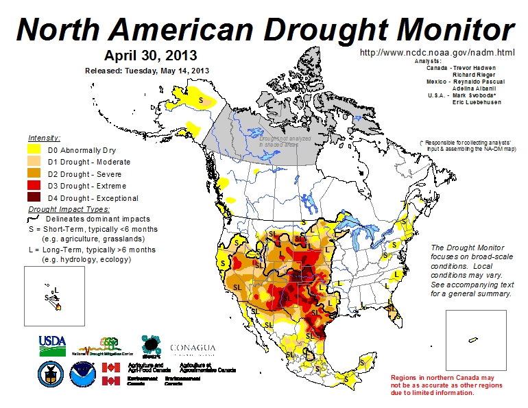
How does Mexico stand right now in relation to drought? Drought currently affects about 40% of the country (see map). Some parts of northern Mexico have been experiencing a severe drought for almost three years. The worst affected states are Chihuahua, Nuevo León, Coahuila, Durango, Zacatecas, Tamaulipas, San Luis Potosí, together with parts of Querétaro, Aguascalientes, Sinaloa and Sonora.

Areas suffering from short-term and long-term drought, April 2013. Click map to enlarge.

Areas suffering from short-term and long-term drought, April 2013. Click map to enlarge.

Last year’s rains did reduce the area suffering from drought from 55.9% of Mexico to 38.6%, but that figure has risen to well over 40% this year.

In 2012, and earlier this year, many major cities, including Mexico City and Guadalajara, had to enforce water rationing for several months, supplying water to individual households only on certain days each week.

As this year’s rainy season begins in central Mexico, dozens of reservoirs are at critically low levels. Reservoirs in Coahuila average only 10% of their capacity, only slightly better than those in San Luis Potosí (12%). Even the populous state of Jalisco faces problems; its reservoirs are at 27% of capacity.

Things are unlikely to improve any time soon since the current long range forecast for this rainy season is for 30% less precipitation than the long term average.

The drought has already caused significant losses to farmers. Livestock owners in northern Mexico have culled herds and are having to buy in supplies of water to top up their private wells. Rainfall so far in 2013 has been well below long-term averages in central and northern Mexico, which may limit the region’s productivity of rain-fed agriculture (mostly wheat, corn, sorghum and other fodder crops).

Authorities at the three levels of government (federal, state and municipal) in many regions are calling for urgent concerted action to help farmers as well as to ensure supplies of drinking water to towns, cities and rural communities.

In Tamaulipas, at least 60 rural communities are confronting a critical water shortage. Farming representatives argue that while the National Water Commission (Conagua) has guaranteed water supply for urban areas, many rural areas remain vulnerable, and lack both potable water and food support on account of harvest failures due to lack of rain. In Tamaulipas alone, drought has affected 22,000 hectares and killed 800 head of livestock in the past year.

In Nuevo León, citrus farmers fear that their harvest, which begins in October will be 40-50% lower than usual. The state government is supporting a 35-million-dollar support program for farmers which includes supplying water by truck, rehabilitating deep wells and offering subsidies for water that farmers buy direct from private suppliers. The spring harvest in Nuevo León was lost completely, and a “severe drought emergency” has been declared in at least 14 municiapliites (Allende, Cadereyta, Dr. Arroyo, General Terán, Higueras, Juárez, Lampazos, Rayones, Sabinas Hidalgo, Santa Catarina, Villaldama, Hidalgo, García and Mina) allowing them access to federal aid.

Besides loss of livestock and crops, the prolonged drought in Mexico is having many other effects, which include:

Migration – In Durango state, more than 1500 Mennonites have left their homes due to the drought, according to Mennonite leader Enrique Peter Klassen, with some of the migrants headed for neighboring state of Chihuahua and others emigrating to Canada.

Wildfires – The first four months of 2013 was the third worst season for forest fires (more than 7000 were reported) in recent history, after 1996 and 2011. According to the National Forestry Commission (Conafor), wildfires ravaged 170,000 hectares, mostly grassland and wooded pastureland, in the first four months of this year. The states which suffered most were Oaxaca (21,000 ha), Baja California Sur (16,000), Guerrero (13,857) and Jalisco (13,697).

Lake Chapala – In the past two years, the level of Mexico’s largest natural lake, Lake Chapala, has once again fallen to crisis levels. (The lake has a long history of fluctuations in level, discussed in detail in our Geo-Mexico, the geography and dynamics of modern Mexico). The lake currently holds 2.84 million cubic meters of water, about 36% of its capacity. Its level has fallen 1.43 meters since last year’s rainy season, the lake’s most dramatic decline for 20 years. The rainy seasons in 2011 and 2012 raised the lake level by only 24 cm and 50 cm respectively, so unless this year’s rains are exceptionally heavy, the lake will continue to drop.

Previous posts related to drought:

Five Mexican beaches gain international Blue Flag certification

 Mexico's geography in the Press  Comments Off on Five Mexican beaches gain international Blue Flag certification
Jun 032013
 

For the first time ever, five Mexican beaches have been awarded Blue Flag certification. The Blue Flag system is a voluntary, international eco-label program run by the non-government, non-profit organization the Foundation for Environmental Education that recognizes beaches where water quality is excellent, where information and environmental education is readily available, and which are well managed, with high standards of safety and services. The announcement was made in Copenhagen, Denmark, where Blue Flag certification was given to 3100 beaches and 625 marinas worldwide.

Blue flag beaches in Mexico 2013

Mexico’s five Blue Flag beaches (see map) are:

  • Chahué, Santa María de Huatulco, Oaxaca
  • Chileno, in Los Cabos, Baja California Sur
  • Delfines, in Cancún, Quintana Roo
  • El Palmar, in Zihuatanejo, Guerrero
  • Nuevo Vallarta Norte, on Banderas Bay in Nayarit

What does the Blue Flag system take into account?

The Blue Flag beach criteria are grouped into four main categories:

1. Environmental Education and Information

The beach must host at least 5 environmental education activities and display information about:

  • coastal zone ecosystems and natural, sensitive areas in the coastal zone
  • bathing water quality
  • the Blue Flag system
  • the code of conduct for the beach area

2. Water Quality

  • Water quality must be “excellent” in line with international standards
  • The beach must not receive any industrial or sewage-related discharges
  • Any nearby coral reefs must be monitored to ensure they remain healthy
  • Algae, seaweed, etc., should be left on the beach unless it adversely affects beach quality

3. Environmental Management

  • A beach management committee must conduct regular environmental audits
  • The beach must comply with coastal zone planning and environmental legislation
  • The beach must be clean, with sufficient waste disposal and recycling bins
  • There must be adequate and clean sanitary facilities
  • Regulations must prevent unauthorized camping, driving and dumping
  • Regulations concerning beach use by domestic animals must be enforced
  • Sustainable means of transportation must be promoted in the beach area

4. Safety and services

The beach must have:

  • first aid equipment and an adequate number of lifeguards and/or lifesaving equipment
  • a system to manage beach use and prevent conflicts and accidents
  • emergency plans to cover any unexpected pollution event
  • safe access to the beach and regular safety patrols
  • a supply of potable drinking water
  • access and toilets for persons with disabilities
  • a map showing the location of all facilities

Related posts:

Swim at your peril through the murky data for Mexico’s beaches

 Other  Comments Off on Swim at your peril through the murky data for Mexico’s beaches
May 062013
 

In the past few months, it has become harder than ever to assess the cleanliness of Mexico’s beaches. Alejandro Calvillo, director of the consumer rights organization “El Poder del Consumidor” recently published an alarming blog post alleging that Mexican authorities have gone to considerable lengths in recent months to mask the true state of Mexico’s contaminated beaches. (Playas contaminadas en México, un secreto de Estado)

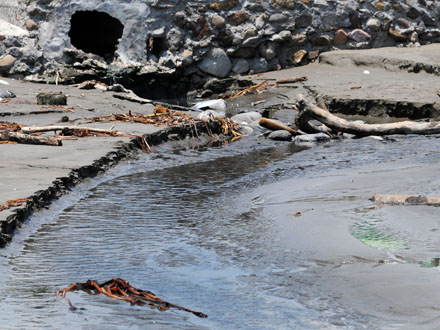
Drain on Mocambo Beach, Veracruz. Credit: La Voz del Sureste.

Drain on Mocambo Beach, Veracruz. Credit: La Voz del Sureste.

Calvillo explains that for several years, government agencies published regular monthly statistics relating to the cleanliness of all the country’s major swimming beaches. While some people queried the veracity of some figures, at least the data was publicly available, and provided some starting point for analysis and discussion. Indeed, this data allowed us to write in Geo-Mexico (p 46) that,

“Coastal waters are also regularly monitored for contamination. The percentage of Mexico’s resort beaches that met national water quality norms rose from 93.7% in 2003 (when 226 beaches in 35 destinations were tested) to 98.4% in 2007 (276 beaches in 46 destinations). Seawater at all coastal resorts is now well within the national standard except for Ixtapa-Zihuatanejo on the Guerrero coast.”

However, soon after the new administration (of president Enrique Peña Nieto) took office, Calvillo claims that a decision was made to cease releasing regular monthly data for beach contamination and to remove the historical time series of beach cleanliness data from government internet sites (such as those of the Health Secretariat and Environment Secretariat). Fortunately, Calvillo’s claims are not the whole truth. Data are still being published for many beaches, via an interactive webpage titled Playas Limpias (Clean Beaches) hosted by the Health Secretariat. However, it does appear to be true that the historical series of pre-2013 data have vanished, and that no data is available, even in 2013, for several beaches that were previously regularly monitored.

There is no doubt that in recent years hundreds of Mexican beaches have on occasion had excessive levels of Enterrococos faecalis, the main bacteriological indicator. (About a decade ago, counts of Enterococcus spp. replaced fecal coliform counts as the best way to assess the water quality at public salt water beaches.) The major source of contamination, despite years of campaigning by environmental groups, comes from hotels, towns and cities that continue to dispose of their effluent directly into the sea, often in close proximity to popular swimming beaches (see photo). Progress has been made in some states, including Jalisco, Nayarit and Veracruz, but there is still a long way to go.

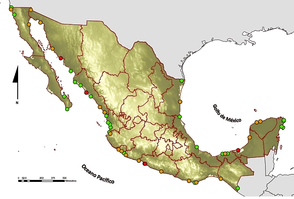
water quality on beaches

Water quality on Mexican beaches, 2011. Source: Atlas Digital del Agua México 2012;
(green=good; yellow=moderate; red=poor)

Calvillo writes that official reports in 2011 (see map) listed 99 beaches where Enterococus levels had been found in excess of 200 Enterococci/100 ml of water on at least one occasion. Values over 200 Enterococci/100 ml are considered to pose a “health risk”, according to Mexican norms. Of these 99 beaches, 70 were on the Pacific coast. The worst beaches included 1 in Baja California Sur (La Paz), 4 in Nayarit (including Sayulita, Rincón de Guayabitos), 3 in Jalisco (including Playa del Cuale in Puerto Vallarta), 10 in Michoacán (including Caleta de Campos, Chuquapan and Playa Nexpa) and 3 in Guerrero. In the worst locations, the Enterococci count was over 20,000/100 ml.

Of the 29 beaches with excessive values on the Gulf of Mexico and on the Caribbean coast, the most polluted were on the Gulf of Mexico, including locations in Tamaulipas, Veracruz and Campeche.

In summer 2012, the 22 beaches that posed a health risk according to the data included Regatas (Veracruz), Rincón de Guayabitos (Nayarit) and Playa Carabali (aka Playa Hornos) in Acapulco (Guerrero).

Despite having made less data available for 2013, in the days leading up to the 2013 Easter vacation period, federal and state government officials repeatedly stressed that all beaches were clean and ready to receive the anticipated hordes of holidaymakers. It is difficult to assess the accuracy of these claims in the absence of more data. Were the beaches really clean, or were tourists in some destinations risking potentially serious gastrointestinal and other diseases every time they went swimming?

Adding another layer of complexity to interpreting the statistics is the fact that several states have massaged the data tables by selectively changing the names of some beaches, and omitting others. For example, Calvillo points out that in 2011 the state government of Veracruz renamed four beaches that had previously experienced high pollution levels so that their historical records would be hard to find:

  • Costa de Oro I became Gaviota II
  • Iguana Norte was renamed Tortuga II
  • Iguana Sur became Pelícano II
  • Penacho del Indio was renamed Pelícano I.

In 2012 Veracruz removed two beaches from its list completely: Iguana Centro and Acuario, which it deemed “no longer of interest to tourists,” perhaps because its 2009 count was a record-breaking 159,490 Enteroccocus/100 ml.

Veracruz is not the only state to have “tweaked” its data. Jalisco decided (in 2009) not to monitor either Conchas Chinas or Boca de Tomatlán, both of which had registered high levels of contamination in previous years. In the state of Guerrero, the main beach in Zihuatanejo (historically one of the most polluted beaches) has not been monitored since 2011 because of “technical problems”. [Note: Measurements began again here in 2013, at about the time this post was first published.]

The moral of this post? The absence of data for any particular beach should not be taken as indicating that it is not contaminated. On the contrary, the absence of data might perhaps better be interpreted as a sure sign that the beach HAS or MIGHT HAVE a problem!

Related posts:

Mexico’s geomorphosites: El Sótano de las Golondrinas (Cave of the Swallows)

 Other  Comments Off on Mexico’s geomorphosites: El Sótano de las Golondrinas (Cave of the Swallows)
Apr 112013
 

El Sótano de las Golondrinas, in the municipality of Aquismón in the state of San Luis Potosí, is a massive limestone sinkhole (pit cave), one of the largest known in the world. In terms of depth, it is thought to be the second deepest sinkhole in Mexico and is probably in the world’s top 20.

The depth of sinkholes can be difficult to determine. For example, in the case of El Sótano de las Golondrinas, its surface opening is about 50 meters by 60 meters (160 by 200 ft) in size, but is on a slope. The depth on the high side is about 376 meters (1220 ft); the depth on the low side is about 330 meters (1090 ft).

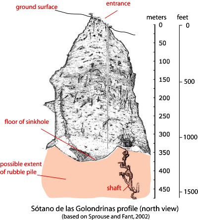
sotano-de-las-golon

Below the surface (see profile) the sinkhole is roughly bottle-shaped. The floor of the sinkhole is about 300 x 135 meters (990 by 440 ft) in area. However, the sinkhole is believed to have formed from the collapse of the roof of an underground cave. As a result, the floor of the sinkhole is not solid rock but rubble that presumably came from the walls and former roof. A shaft on one side extends down at least another 100 m, suggesting that the true floor of the original cave lies at least that far beneath the current rubble-strewn floor.

US photographer Amy Hinkle shot some spectacular images earlier this year in this cave.  The accompanying article highlights the “secret garden” that “nestles 300 meters beneath the surface of the earth”.

The cave’s name (literally “basement of the swallows”) derives from the thousands of white-collared swifts that inhabit the overhanging walls of its interior. They spiral out of the cave every morning over a period of 25-30 minutes and return to their cave homes close to sunset. Large numbers of green parakeets also live in the cave.

The floor of the sinkhole is home to a rich plant life, as well as a diverse selection of  fungi, millipedes, insects, snakes, and scorpions.

The original cave is thought to have been formed by a lengthy period of water erosion along a major fault line in the lower Cretaceous limestone in the Sierra Huasteca (part of Mexico’s Eastern Sierra Madre). Over time, the cave became larger as a consequence of both the water erosion and due to mass movements (landslides, rockfalls) on its walls. Eventually, the size of the cave was so large that its walls could no longer support its roof which then collapsed into the cave, leaving the open air sinkhole seen today. Following heavy rain, short-lived waterfalls cascade down the sides of the sinkhole.

The first documented exploration of El Sótano de las Golondrinas was apparently in 1966. Since that time, the cave has become a popular destination for various adventure sports including rappelling, abseiling and base jumping (no longer allowed).

There are several other very deep sinkholes in the same general area, including Hoya de las Guasguas (with a 202 m deep entrance shaft) and Sótano del Barro (402 m in depth).

Some ornithological studies have found that the bird population of El Sótano de las Golondrinas is decreasing, perhaps due to the disturbance caused by the increasing number of human visitors. To limit disturbance, access and activities are more tightly controlled. For instance, descents into the cave are now strictly limited to daylight hours when the birds are absent, and a no-fly zone has been established around the cave, primarily to avoid helicopter disturbance.

El Sótano de las Golondrinas is yet another outstanding example of a geomorphosite in Mexico. Mexico has literally thousands of geomorphosites. Among those described in previous Geo-Mexico posts are:

References:

Related article:

Mexico seen as the “Flavor of the Month” among Latin American Economies

 Mexico's geography in the Press  Comments Off on Mexico seen as the “Flavor of the Month” among Latin American Economies
Apr 062013
 

In a presentation entitled “Mexico’s Outlook” in Ajijic, Jalisco, Mexico, on 20 March 2013, noted Mexican political economist Leo Zuckermann explained how many economists see Mexico as the “flavor of the month” among Latin American economies.  Brazil previously was the star of Latin America as evidenced by the 14-20 November 2009 cover of  The Economist. However, Brazil’s performance slowed considerably in 2012; its GDP grew by only 1.0% and the dollar value of its stock market actually declined by 0.5% in 2012. (The Economist, 19 January 2013, p 93)

Economist covers

Mexico is the new star according to The Economist 14-page Special Report on Mexico in its 24-30 November 2012 edition. Mexico’s GDP grew by 4.0% in 2012, faster than the US, Canada and all European economies, though it did trail China (7.7%), India (5.4%), Indonesia (6.3%) and Thailand (5.8%). In dollar terms its stock market shot up an impressive 33.6% in 2012, tied with Germany and faster than all other sizable countries, except Turkey (75.8%), Thailand (45.9%) and Egypt (43.9%). (The Economist, 19 January 2013, pp 92, 93).

Mexico is expected to grow by 3.5% in 2013. However, it should be noted that after appearing on The Economist cover in November 2009, Brazil’s GDP declined steadily from over 8% to only 1%. We hope that Mexico can avoid this Economist cover jinx.

Mexico’s recent growth and positive outlook is largely dependent on continued expansion of exports, particularly the sale of automobiles and electronics to the USA. In 2013, Mexico is expected to surpass Japan as the leading exporter of light vehicles into the USA.

Though Mexican industrial export numbers are impressive, many of the components of these exports are initially imported. For example, the foreign content of Mexico’s electronic exports is 61%, compared to about 40% for China, 45% for Korea and only 11% for the USA.

Much of Mexico’s export capacity results from foreign direct investment in Mexico. However, such investment declined from nearly $30 billion a year in 2007 and 2008 to only $12.7 billion in 2012 (The Economist, 19 January 2013, pp 92, 93). This could limit export growth in future years. Furthermore Mexican direct investment abroad in 2012 was $25.5 billion almost twice the amount foreigners invested in Mexico. Prior to 2012 foreigners invested far more in Mexico than vice versa. This trend suggests that many Mexican investors see better opportunities abroad than in Mexico. Such investments are one reason for the rapid foreign expansion of some major Mexican multinational corporations such as Cemex, América Móvil, FEMSA and Bimbo. Another factor suggested by these numbers is that both foreign and Mexican investors do not see many attractive opportunities for domestic industries selling to the Mexican market. If Mexico is indeed now the “flavor of the month,” it remains to be seen if Mexico can retain its current popularity.

Related posts:

Environmental news briefs relating to Mexico

 Mexico's geography in the Press  Comments Off on Environmental news briefs relating to Mexico
Apr 022013
 

This post describes several newsworthy developments relating to Mexico’s natural environment.

Financing to fight deforestation

The Inter-American Development Bank is giving Mexico $15 million in financial and technical assistance to support climate change mitigation efforts. The program will help communities and ejidos finance low carbon projects in forest landscapes in five states, all of which have high levels of net forest loss: Oaxaca, Yucatán, Quintana Roo, Jalisco and Campeche.

The program includes a $10 million loan for financing projects that must reconcile economic profit for the communities and generate environmental benefits through reducing the pressure on forests and promoting enhancement of carbon stocks. In addition, a $5 million grant will provide financial and technical assistance to support the viability of individual projects, by strengthening technical, financial and management skills.

The IDB says that the program is a pilot project that will allow lessons to be learned for its replication in other key geographic areas in Mexico. It should demonstrate a viable business model that promotes the reduction of deforestation and degradation while increasing economic returns. [based on an IDB press release]

Mexican company converts avocado seeds into biodegradable plastic

A Mexican company called Biofase has developed a way to turn avocado pits into 100% biodegradable plastic resins. Avocado pits are normally discarded as waste. Biofase will collect some of the estimated 30,000 metric tons of avocado pits discarded each month for processing. The company has patented the technology and is looking for additional raw material containing some of the same chemicals as avocados.

Huichol Indians oppose peyote conservation measure

A presidential decree signed last November prohibits the harvesting of the hallucinogenic peyote cactus from two protected areas in the state of San Luis Potosí. The decree has met fierce opposition from the indigenous Huichol (Wixarika) people, for whom the peyote is a sacred plant. The Huichol undertake a lengthy pilgrimage each year to gather peyote for subsequent use in their ceremonies.

The restriction on peyote harvesting is the latest in a long line of problems faced by the Huichol including the incursion by a large number of mining companies onto traditional territory. The Regional Council for the Defense of Wirikuta has demanded that the government guarantee the Huichol’s right to pick peyote, and called for the cancellation of 79 mining concessions (most of them to Canadian companies) that impinge on their sacred land. Critics claim that mining is having a devastating impact on the local environment, especially because the companies involved are using large quantities of highly toxic cyanide.

Expand the port or protect the coral reef?

In Avalan destruir arrecifes para ampliar puerto de Veracruz published in Mexico City daily La Jornada, Luz María Rivera describes how one of the final acts of the previous administration was to redraw the boundaries of the protected area of coral reef off the coast of Veracruz state. The new boundaries have reduced the protected offshore area near the cities of Veracruz, Boca del Río and Alvarado by about 1200 hectares (3000 acres). The redrawing of the protected area is to enable the expansion of the port of Veracruz, one of the country’s largest, and almost double its capacity. Government officials claimed that the area affected was already “damaged” and that the reef system was 98% or 99% “dead”.

Government-NGO accord to protect Mexican whale sanctuary

The Mexican government has signed an accord with the NGO Pronatura Noroeste to improve the protection of Laguna San Ignacio, the Pacific coastal lagoon which is a major breeding ground for gray whales. The lagoon has 400 kilometers (250 miles) of coastline, bounded by wetlands and mangroves, and is part of the El Vizcaino Biosphere Reserve in the northern part of the state of Baja California Sur. The accord calls for joint development of plans for protection, monitoring and tracking the whales and other species that inhabit the lagoon, as well as  establishing protocols for resolving any eventual environmental contingencies.

Related posts:


Popocatapetl Volcano and Colima Volcano continue to erupt

 Mexico's geography in the Press, Updates to Geo-Mexico  Comments Off on Popocatapetl Volcano and Colima Volcano continue to erupt
Mar 302013
 

In our series of brief updates on topics featured in previous Geo-Mexico posts, we look this week at the continuing eruption of two major volcanoes: Popocatapetl Volcano (between Mexico City and Puebla) and Colima Volcano (on the Jalisco-Colima state border in western Mexico).

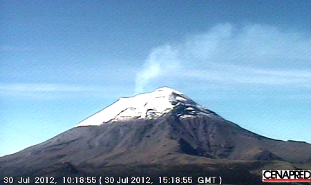
Popocatepetl, 30 July 2012

Popocatepetl, 30 July 2012

Since our previous post, about a year ago, entitled Alert level rises as Popocatepetl volcano starts to erupt, Popocatapetl Volcano (photo) has continued to be active, with up to 250 activity events a day. The alert level has been reduced slightly to Yellow Phase 2, the fourth highest level. This level indicates intermediate scale explosive activity and possible expulsion of lava, explosions of increasing intensity and wind-blown ash falling on nearby villages. The volcano is monitored daily, and updates from CENAPRED  (in Spanish and English) are issued every 24 hours.

The report issued on 27 March is typical of recent months. In the previous 24 hours, there were 83 low intensity events with emissions of gas, water vapor and ash. The two largest events sent material rising 1000 meters and 600 meters into the atmosphere respectively, before the wind blew the material north eastwards (away from Mexico City).

Colima Volcano

In January 2013, we reported how Colima Volcano erupts, destroying lava dome first created in 2007. The volcano has continued to erupt in the ten weeks since then. The experts monitoring the volcano have reported up to 200 eruptive events a day, with numerous minor emissions of lava. Local villagers have been asked to remain on alert, though the experts are not yet calling for any villages to be evacuated.

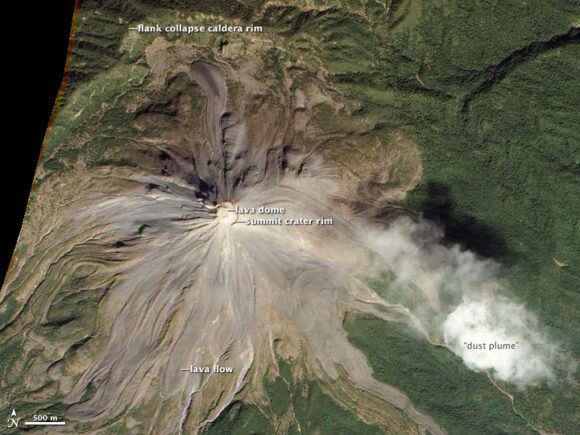
The image below (source: Nasa Earth Observatory) shows Colima Volcano in 2010, part way into its current eruptive phase which is expected to last several years. The image shows the evidence at that time of four different types of volcanic activity:

  • lava dome growth
  • explosive eruptions
  • flank collapse
  • lava flows.

(Note that the 2013 eruptions have significantly altered the top of the volcano since this image was taken).

Nasa Earth Observatory)

Colima Volcano in 2010 (Nasa Earth Observatory)

Related posts:

The geography of Mexico’s drug trade: new cartels involved in turf wars

 Mexico's geography in the Press, Updates to Geo-Mexico  Comments Off on The geography of Mexico’s drug trade: new cartels involved in turf wars
Feb 202013
 

As we suggested a year ago – Mexico’s drug cartels and their shifting areas of operation, a 2012 update  – it is increasingly difficult to track the areas of operation of the major drug trafficking groups in Mexico. The U.S. Department of the Treasury’s Office of Foreign Assets Control recently added a new narcotrafficking group in Mexico, the Meza Flores family, to its list of Foreign Narcotics Kingpins. (This designation prohibits people in the USA from engaging in transactions with the named individuals or their organization, and freezes any assets the individuals or organization may have under U.S. jurisdiction).

According to the Treasury Department’s statement, the Meza Flores family began operations in about 2000 and is responsible for the distribution of considerable quantities of methamphetamines, heroin, cocaine and marijuana in the USA. It is headed by Fausto Isidro Meza Flores (aka “Chapito Isidro”) and is based in the town of Guasave, in the state of Sinaloa. (Meza Flores was previously in the Juárez cartel before becoming a high ranking member of the now defunct Beltran Leyva cartel).

The Meza Flores group is a direct rival of the long-established and very powerful Sinaloa cartel. The Sinaloa cartel is headed by Joaquín “El Chapo” Guzmán Loera, who has been on the run since escaping from the maximum security jail in Almoloya de Juárez, near Toluca, in 2001. According to Forbes Magazine, Guzman Loera is currently Mexico’s 10th richest individual, with assets of around one billion dollars.

Mexico’s “War on Drugs” in recent years has led to a fragmentation of the major cartels. Some experts claim that as many as 80 distinct groups are now involved in drug production and trafficking. Many of these groups are small and highly localized, but this fragmentation has increased the incidence of turf wars between rival groups. These turf wars have caused extreme levels of violence in some parts of the country. Once one side is firmly in control, the violence drops.

The current federal administration has said that some 70,000 people died in Mexico between 2006 and 2012 as a result of the activities of organized crime. Recent press reports such as Jalisco: La invasión de Los Templarios claim that one on-going boundary war is along the state boundary between Michoacán and Jalisco. This conflict is between the Michoacán-based Knights Templar (Los Caballeros Templarios, LCT) and the Jalisco-based New Generation cartel (CJNG).

The LCT is comprised largely of former members of  La Familia Michoacana (LFM), a group which is now almost defunct. Other members of LFM joined the Zetas, the Sinaloa cartel’s arch enemy. The CJNG started out as enforcers for the Sinaloa Cartel.

Violence linked to this particular turf war has occurred in numerous municipalities including Jilotlán de los Dolores, Pihuamo, Mazamitla, San José de Gracia, La Barca, Atotonilco, Ayotlán, Tizapán el Alto, Tuxcueca, Jocotepec and Chapala (all in Jalisco), as well as Briseñas, Yurécuaro, Sahuayo, Marcos Castellanos, La Piedad, Zamora, Cotija de La Paz, Tepalcatepec, Los Reyes, Peribán and Apatzingán (all in Michaocán).

This is not the only turf war currently underway in Mexico. For example, further north, another recent hot spot has erupted along the Durango-Coahuila border, especially in the La Laguna area centered on the city of Torreón.

Related posts:

The geography of the Huichol Indians: cultural change

 Other  Comments Off on The geography of the Huichol Indians: cultural change
Feb 182013
 

Huichol Indians may have retained many of their ancestral traditions, such as shamans and their annual cycle of ceremonies, but Huichol culture has changed significantly in the past three hundred years.

During colonial times, the Huichol adopted string instruments, the use of metal tools, and the keeping of animals such as sheep, horses and cattle. They also accepted some aspects of Catholic religion.

Beginning in the 1950s, government programs financed the first airstrips in the region. Government agencies have since improved roads, opened clinics and constructed schools for basic education and trades. The government’s efforts have included agricultural aid stations, the drilling of wells, and support for the introduction of more modern agricultural techniques and equipment, such as barbed wire and tractors. Other programs have focused on providing alternative sources of revenue such as beekeeping.

Modern adaptation: Huichol "vocho" exhibited at the Smithsonian in 2012

Modern adaptation: Huichol “vocho” exhibited at the Smithsonian in 2012

All these changes have come at a price. The ancestors of the Huichol practiced a nomadic lifestyle over a large expanse of land in order to acquire the resources they needed for survival. When the Huichol were pushed back into the mountains,they adapted by undertaking an annual migration to gather their sacred peyote. At the same time, they became increasingly dependent on the cultivation of corn. However, in such marginal areas where rainfall is unreliable the corn harvest is never guaranteed and in bad years starvation is a real possibility.

Closer links to the outside world have meant that the Huichol can now buy cheap, bottled alcohol, and face increased pressure from outsiders who want more grazing land, timber and minerals. They have also led to the out-migration of many Huichol, whether permanently to nearby cities or seasonally to work on tobacco plantations in Nayarit. In the past fifty years, this has led to some innovations in Huichol art, including the addition of large yarn paintings and larger items decorated with complex bead work (see image) to their traditional arts and crafts.

Even though the Huichol are one of the most isolated (not just geographically but also economically and socially) indigenous groups in Mexico, there is nothing static about their culture. It will be interesting to see what changes the future brings.

Related posts:

Bibliography:

This mini-series has made extensive use of several resources, including:

  • Barrin, Kathleed (ed) Art of the Huichol Indians. The Fine Arts Museums of San Francisco, 1978.
  • Mata Torres, Ramón. La Vida de los Huicholes. Tomo I. 1980. Guadalajara, Jalisco.
  • Mata Torres, Ramón. El Arte de los Huicholes. Tomo II. 1980. Guadalajara, Jalisco.
  • Neurath, Johannes. Pueblos Indígenas del México Contemporáneo: Huicholes. Comisión Nacional para el Desarrollo de los Pueblos Indígenas / UN Development Program. 2003. [link is a pdf download]

Which political party has the most state governors?

 Other, Updates to Geo-Mexico  Comments Off on Which political party has the most state governors?
Feb 162013
 

Mexican governors are elected for single six-year terms; re-election is not permitted by the Mexican Constitution. The terms of governors in different states overlap; for example, seven of the 32 governors began their term of office in 2012.

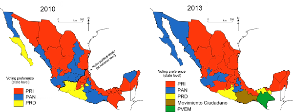
The PRI (Partido Revolucionario Institucional, Institutional Revolutionary Party) currently holds 19 of the 32 governorships spread throughout Mexico (states colored red on map), except for the northwest and extreme south. On 1 March 2013, PRI will gain another governorship when Aristoteles Sandoval of PRI replaces the current PAN Governor of Jalisco. Although PRI Presidential candidate, Enrique Peña Nieto, easily won the Mexican Presidency in 2012, of seven new governors inaugurated in 2012, only three were from PRI.

Ex-President Calderón’s PAN (Partido Acción Nacional, National Action Party) is a distant second with seven governorships (blue on map); six after 1 March 2013. Four of the PAN governorships are in the northwest.

The PRD (Partido de la Revolución Democrática, Party of the Democratic Revolution) is third with four governorships (yellow on map). Three of the PRD governors took office in 2012. PRD has held the important governorship of the Mexico City Federal District since 1988.

State governorships, 2010 and 2013

State governorships, 2010 and 2013

The Governor of Oaxaca (brown on 2013 map) is from the Movimiento Ciudadano (Citizens’ Movement, formerly known as Convergencia or Convergence), which supported López Obrador in the 2006 presidential election. The Governor of Chiapas is from the PVEM (Partido Verde Ecologísta de México; Mexico’s Green Party; green on the 2013 map).

The north-south political divide that we have referred to in some previous posts, including the equivalent map for 2010 shown above, is no longer evident in the current pattern of state governorships.

Related posts:

The crater lake of Santa María del Oro yields evidence for climate change

 Books and resources  Comments Off on The crater lake of Santa María del Oro yields evidence for climate change
Feb 142013
 

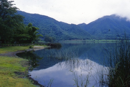
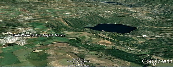
A magnificent crater lake nestles in a centuries-old volcanic crater a short distance east of the town of Santa María del Oro in Nayarit.

The connecting road from Highway 15 first passes through the former mining town of Santa María del Oro and then rises slightly to offer a splendid view of the beautiful slate-blue lake (known locally as “La Laguna”), set in a ring of verdant hills. In recent years, the lake, a good example of a geomorphosite, has become important for tourism with accommodations ranging from RV spaces to a boutique hotel. It takes about an hour and a half to stroll round the track that encircles the crater lake. Other attractions include visiting an abandoned gold mine (which offers a glimpse into the area’s past), birding, mountain biking, swimming or hiring a rowboat or kayak to venture out onto the lake.

Crater Lake, Santa María del Oro. Credit: Tony Burton

Crater Lake, Santa María del Oro. Credit: Tony Burton

This usually quiet lake has proved to be a valuable source of information for geologists and climatologists investigating the history of climate change in this region of Mexico.

The researchers who published their findings in 2010 in the Bulletin of the Mexican Geological Society extracted a sediment core from the deepest part of the lake. The relatively small area of the drainage basin surrounding the lake and the relatively steep slopes of surrounding hills mean that the sediments entering the lake are rarely disturbed after they are deposited. Wind and wave action are limited. The depth of the lake (maximum 65.5 meters) also helps to ensure that sediments remain undisturbed for centuries. This gives perfect conditions for a reliable sediment core.

Santa María del Oro. Credit: Google Earth

Santa María del Oro. Credit: Google Earth

The team analyzed the titanium, calcium and magnetism levels of successive thin slices of the core. By comparing the core with historic records and previous tree ring analyses from the same general area, they were able to accurately date each slice. The titanium levels in each slice allowed the researchers to quantify how much runoff occurred in that year, a proxy indicator of precipitation.

The team identified 21 significant drought events over a period of 700 years. The six most marked droughts occurred in 1365–1384, 1526, 1655-1670, 1818, 1900 and 1930-2000. They found periodicities of 25, 39, 50, 70 and 117 years for drought events, meaning that droughts occurred at fairly regular intervals of about 20-25 years.

The researchers then looked at the possible correlation between periods of drought and two distinct climatological factors: a shift to the south in the position of the Inter Tropical Convergence Zone (ITCZ) in summer and the occurrence of El Niño Southern Oscillation (ENSO) events. When the ITCZ does not extend as far north as usual during Mexico’s summer rainy season, states such as Nayarit and Jalisco receive less than their normal amount of rainfall. During ENSO events, rainfall is also diminished in central and western Mexico.

Of the 21 droughts identified and studied, 7 proved to be statistically linked to ENSO events, 10 to ITCZ movements, and the remaining 4 events were closely linked to a combination of both.

As the study concludes, titanium analysis of sediments may allow for a more refined record of climate change in the period prior to reliable historic or instrumental records which might improve the understanding of how and why climate change occurred in past

Santa María del Oro is also worth visiting because it is only a short distance away from the edge of the canyon of the River Santiago and the El Cajón hydro-electric power project, one of three major HEP projects located along that river.

Source article:

Susana Sosa-Nájera, Socorro Lozano-Garcí, Priyadarsi D. Roy and Margarita Caballero. Registro de sequías históricas en el occidente de México con base en el análisis elemntal de sedimentos lacustres: El caso del lago de Santa María del Oro. Boletín de la Sociedad Geológica Mexicana, Vol 62, #3, 2010, p 437-451.

Santa María del Oro and surrounding areas are described in chapter 24 of the recently published 4th (Kindle/Kobo) edition of my Western Mexico: A Traveler’s Treasury (Sombrero Books, 2013).

Related articles:

The cultural geography of Mexico’s carnival celebrations

 Other  Comments Off on The cultural geography of Mexico’s carnival celebrations
Feb 092013
 

Carnival celebrations are underway in many Mexican towns. Carnival (carnaval) is a time for merry-making in the days prior to Ash Wednesday, the beginning of Lent in the Christian liturgical calendar. (In 2013, Ash Wednesday falls on 13 February.) Carnival originated in Italy and was introduced into Mexico several centuries ago by the Spaniards. Even though the proportion of Mexico’s population that is Catholic has fallen steadily in recent decades – see Religious diversity is increasing in Mexico – the popularity of carnival shows no signs of decline.

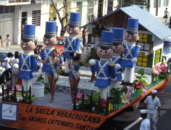
Carnival float, Veracruz

Carnival float, Veracruz

According to Wikipedia, more than 220 towns in Mexico celebrate Carnival. Frances Toor, an authority on Mexican folklore, claims that carnival festivities in Mexico City “reached their climax about the middle of the nineteenth century and have died out since the 1910–1920 Revolution.” Very few large cities in Mexico have important carnival celebrations, the most notable exceptions being Veracruz, Mérida and Mazatlán.

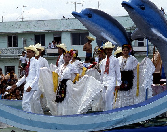
Carnival float, Veracruz

Carnival float, Veracruz

By far the most interesting carnival celebrations in Mexico are those held in smaller towns and villages in non-tourist areas. In this regard, the carnival in Huejotzingo, in the state of Puebla, stands out. It is aptly labeled by Toor in “A Treasury of Mexican Folkways”, published in 1947, as “the most elaborate and brilliant of the village carnivals”. Toor describes this carnival in considerable detail, saying that it “dramatizes the capture and death of Agustín Lorenzo, a famous bandit, who with his men used to rob convoys between Mexico City and Vera Cruz and then hide in the near-by gorges or mountains. According to the carnival plot, he ran off with the beautiful young daughter of a rich hacendado, took her to one of his hideouts and was having a wedding celebration when the federal soldiers fell upon them.”

In Toor’s time, about 1000 villagers participated each year, dressed as soldiers in elaborate costumes representing several different battalions. She notes that “In recent years [1940s] some new features have been added to the Huejotzingo carnival. At dawn, all the forces fight against the French, who occupy the plaza, which is besieged and taken. The bride is said to be the beautiful daughter of the French Emperor Maximilian, instead of a rich hacendado”. Today, more than 2000 villagers take part. Most modern descriptions of the carnival in Huejotzingo describe it is an intermixing of three separate plots: the Battle of Puebla (where Mexican forces defeated the French on 5 May 1842), the kidnapping of the mayor’s daughter, and the first Christian marriage in Mexico.

Other places with idiosyncratic carnival celebrations include Huixquilucan (State of México), Calnali (Hidalgo), Tlayacapan (Morelos), Tuxpan de Bolaños (Jalisco), San Juan Chamula and Chenalho (both in Chiapas) and Zaachila (Oaxaca).

This Youtube video clip shows 2012 carnival revelry in Cozumel:

As with almost every aspect of Mexico’s cultural geography, there is no one fixed or rigid “tradition”. Instead, there have been so many significant changes over time that today’s celebrations of carnival across Mexico are characterized as much by their distinctive regional variations as by their similarity.

Related post:

The geography of the Huichol Indians: economy, lifestyles and settlements

 Other  Comments Off on The geography of the Huichol Indians: economy, lifestyles and settlements
Feb 072013
 

In this post we take a closer look at the traditional life and settlement patterns of the Huichol Indians.

The origins of the Huichol are unclear. The Wixárika themselves believe they arrived in the Jalisco-Nayarit area from the Valley of the Mexico, though most anthropologists believe it is more likely that they came originally either from the north or from the Nayarit coast.

Huichol economy and lifestyle

In the Huichol heartland area (shown on the map) the rainy season normally begins in June and lasts until October, a similar timing to most of central and western Mexico. While average temperatures in the area are usually between 15 and 20 degrees Centigrade, there can be sharp frosts in winter.

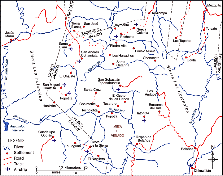
huichol-villages

The dispersed rural settlement pattern of the Huichol heartland. Credit: Tony Burton / Geo-Mexico; all rights reserved

Huichol family groups rely on the subsistence farming of corn, beans and squash, which are grown together in a small plot or garden (coamil). Tomatoes, chiles and gourds are also produced, Cultivation is often on steep slopes. Land is cleared by slash and burn. A few cattle may be kept, largely because of their value as trade items. Meat is rarely available except on ceremonial occasions. Some fishing is practiced, and wild plants also form part of the typical Huichol diet. Merchants supply other items such as salt, shells, feathers, canned drinks and sandals.

The typical Huichol home is a simple, one-room dwelling, usually rectangular in plan, with a thatched roof. Some homes have a second room for cooking.

The isolation of the Huichol has enabled them to retain almost all of their traditional customs. Anthropologists who have lived among the Huichol affirm that religion for the Huichol is not part of life, it is life.

Three of the most important symbols for the Huichol are deer, corn (maize) and peyote. In some ways, these three items underline the fact that the Huichol culture has undergone a transition from a lifestyle based on hunting and gathering towards one based on sedentary agriculture.

Settlements and districts

During colonial times, the area inhabited by the Huichol Indians was first divided into three and then, later, five administrative districts:

  • Santa Catarina (elevation about 1000 meters above sea level). Santa Catarina is a day’s walk from the nearest airstrip.
  • San Sebastián (elevation 1400 meters).
  • Tuxpan (aka Tuxpan de Bolaños; elevation 1060 meters).
  • San Andrés Cohamiata (elevation 1860 meters). This has the best airstrip and is the main Huichol ceremonial center. While many of the people did not adopt Catholicism, San Andrés has more services, including a medical clinic, and more working opportunities.
  • Guadalupe Ocotán (elevation 1050 meters). More of the Huichol living here accepted Catholicism and are more acculturated. Most children attend school; many people wear “mestizo” clothing.

Each of these districts has its own autonomous government, and there are relatively few formal links between the districts or “communities”. Each community is headed by a governor (Tatohuani), with the office transferred to a new leader every January following an elaborate ceremony. Each community also has a parallel religious government headed by its shamans (maraakames).

The transportation challenges in this region are evident from the number of small airstrips shown on the map and the paucity of road links. Villages only 5 or 10 kilometers away from each other “as the crow flies” may be almost impossible to travel between because of the river canyons and steep slopes. A relief map of this area shows that most settlements are perched on whatever flatter land is available, often on the plateau top.

Given the lack of formal links between districts, and the terrain, it is not surprising that the settlement pattern in the Huichol heartland area is highly dispersed, with a very large number of tiny settlements, mostly kinship settlements where all members belong to the same extended family. There are more than 400 distinct settlements (rancherías or ranchos) in the region and many of the settlements are a considerable distance from their nearest neighbors. This part of Mexico exhibits one of the clearest examples in the country of dispersed rural settlements.

Key questions raised by the dispersed settlement patterns of this area:

  • What does “development” mean in the context of the Huichol Indians?
  • Does this dispersed settlement pattern inhibit the future economic and social development of the Huichol people? If so, how does it do so, and what could be done to overcome the difficulties it causes?
  • Would development be easier if most or all of the small scattered communities were congregated into a smaller number of larger settlements?

Related posts:

Jan 312013
 

The remote mountains and plateaus of the north-west corner of Jalisco where it shares borders with the states of Nayarit, Durango and Zacatecas (see map) is home to some 18,000 Huichol Indians, as well as their close cousins, the Cora.

The Huichol heartland (central part of the rectangle on map) is an area of about 4100 square kilometers which straddles the main ridges of the Western Sierra Madre, with elevations of between 1000 and 3000 meters above sea level. There are dozens of dispersed small Huichol rural settlements (ranchos) in the area. We will take a detailed look at their settlements and traditional way of life in a future post.

In this post we focus on the regional setting of the Huichol heartland and the links that now exist between the Huichol and other places in the same general region of Mexico.

huichol-regional-setting

The Huichol refer to all other Mexicans (whatever their ethnic origin) as “mestizo”. The nearest non-Huichol “mestizo” towns are  Mezquitic, Colotlán, Bolaños, Chimaltitán and Villa Guerrero, all in Jalisco, and all about 2-3 days’ walk from most Huichol settlements.

Migration to the tobacco fields

Many Huichol have left their home villages, where economic prospects are limited, in search of employment elsewhere. This kind of migration is often temporary or seasonal. For example, some Huichol undertake seasonal agricultural work, from November to May, on the tobacco plantations of coastal Nayarit. This may guarantee some income but the living conditions are poor, the work is hazardous and pesticide poisoning is all too common. Most of these Huichol return home each summer to plant their corn, beans and squash.

The center of tobacco cultivation is Santiago Ixcuintla, a town which has a very interesting support center for Huichol Indian culture and crafts. Tobacco cultivation, no longer as important as it once was, required as many as 15,000 local plus 27,000 temporary workers. While the businesses involved all have guidelines about how chemical sprays (including including Lannate, Diquat, Paraquat and Parathion) should be applied, these have rarely been effectively enforced. Many of the Huichol live in shanty-like accommodation in the fields, with no ready access to potable water. Some studies have shown that pesticide containers are sometimes used to carry drinking water. There have also been many cases of organophosphate (fertilizer) intoxication from working and living in the tobacco fields.

The tobacco workers often have no place to purchase basic food supplies apart from a store run by the same company they work for. The company holds their wages until the end of the week, and deducts the cost of any items they have bought. This is a virtually identical system to the “tienda de raya” system that was employed by colonial hacienda owners to economically enslave their workers.

Making the pesticide problems for the Huichol even worse is the fact that chemicals including DDT have been used to fumigate parts of Sierra Huichol in order to kill malarial mosquitoes. The Huichol refer to the DDT sprayers as “matagatos” (cat killers). The effects of most of these chemicals are cumulative over time.

Movement to the cities

In the past thirty years, about four thousand Huichols have migrated to cities, primarily Tepic (Nayarit), Guadalajara (Jalisco) and Mexico City. It has also become quite common to see Huichol Indians (usually the menfolk in their distinctive embroidered clothing) in tourist-oriented towns, such as San Blas and Puerto Vallarta. To a large extent, it is these city-wise Huichols who, in search of funds, have drawn attention to their rich culture through their artwork and handicrafts. In addition to embroidered bags and belts, the Huichol make vibrant-colored bead work, yarn crosses and (more recently) yarn paintings, often depicting ancient legends. Income from artwork is very variable, but it is an activity that can include the participation of women. However, trading may depend on middle men who siphon off potential profits, and the Huichol artists now face stiff competition from non-Huichol imitators.

Encroachment by outsiders

As we saw in an earlier post—The sacred geography of Mexico’s Huichol Indians—the Huichol consider themselves the guardians of a large part of western Mexico. Inevitably, traditional Huichol lands have been encroached upon by outsiders for agriculture and ranching. Some non-Huichol ejidos have been established on land that was formerly communal Huichol land. Unfortunatley, the Huichol have had little defence against these pressures.

Mining interests are also threatening some traditional Huichol areas. For example, there is a serious dispute between the Huichol and the First Magestic Silver company over the area the Huichol call Wirikuta (where they gather their sacred peyote on an annual 800-km round-trip pilgrimage). First Majestic Silver has obtained permission from the Mexican government for its proposed La Luz Silver Project, which will extract silver from the Sierra de Catorce, despite this area’s historic significance for the Huichol.

Want to see their artwork?

One of the museums in the city of Zacatecas houses one of the relatively few museum quality displays of Huichol Indian art anywhere in Mexico. The collection was bought by the Zacatecas state government, in order to prevent its sale to the University of Colorado. The 185 embroideries (as well as many other items) were collected by Dr. Mertens, an American doctor who lived in Bolaños and worked for the Bolaños mining company. After the company closed its mines, Mertens continued to live in Bolaños, and to offer medical services to the Huichol, asking only for the occasional embroidery in lieu of payment. Another place to see high quality Huichol art is the small museum in the Basilica de Zapopan in the Guadalajara Metropolitan Area.

Related posts:

The sacred geography of Mexico’s Huichol Indians

 Other  Comments Off on The sacred geography of Mexico’s Huichol Indians
Jan 242013
 

The remote mountains and plateaus where the states of Jalisco, Nayarit and Zacatecas all meet is home to some 18,000 Huichol Indians, as well as their close cousins, the Cora. The Huichol (Wixárika = “the healers” in their own language) live in scattered, extended family, settlements (ranchos) and rely entirely on oral tradition. They are intensely religious, and see their time-honored responsiblity as protecting nature’s creations. Their shamen perform elaborate ceremonies to a pantheon of gods to ensure  bountiful crops, health and prosperity, as well as to preserve nature and heal the Earth.

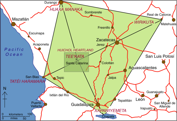
The center of the Huichol world – Tee’kata (see map) – coincides with the village of Santa Catarina in the Huichol heartland. Central to some Huichol ceremonies is peyote, an hallucinogenic cactus, obtained from an annual pilgrimage eastwards to the sacred land of Wirikuta, near Real de Catorce in San Luis Potosí. The pilgrimage is an 800 km (500 mile) round trip. Peyote (Lophophora williamsii) is called jicuri by the Huichol.

Map of the sacred geography of Mexico's Huichol Indians

The sacred geography of Mexico’s Huichol Indians. Credit: Tony Burton/Geo-Mexico; all rights reserved.

Equally important points in the Huichol cosmos lie to the north, west and south:

  • north: Huaxa Manaká =  the mountain of Cerro Gordo in Durango
  • west: Tatéi Haramara = the Isla del Rey, an island near San Blas
  • south: Xapawiyemeta =  Scorpion Island (Isla de los Alacranes) in Lake Chapala

The sacred geography of the Huichol (shown by the rhombus on the map) echoes the significance they attach to the number 5. They view the world as having five regions, corresponding to five mothers (one under the earth and the other four at cardinal points). They believe that the sun is carried through the universe by five serpents. The flowers of their sacred peyote come in five colors, as do their cobs of corn  (Blue, white, reddish purple, yellow, multicolor). The Huichol have different terms for the five colors of corn, which are closely associated with the five main points of their cosmos:

  • yuawime – blue – south
  • tuxame – white- north
  • ta+lawime  – purple – west
  • taxawime – yellow – east
  • tsayule – multicolor – center

huichol-yarn-crossEvery rhombus has four corner points and a center. Their traditional yarn crosses (often mistakenly referred to as “God’s Eyes”) are made by wrapping colored yarn around two twigs to form a rhombus of color. Most yarn crosses use several different colors. Compound yarn crosses are made by adding small yarn crosses at each end of the two main supporting twigs, giving five crosses (eyes) in total. Huichol fathers will make a simple yarn cross when a child is born, adding additional crosses annually until the yarn cross is considered complete. This, of course, is assuming that the child survives, given that infant mortality among the Huichol is very high.

The colors used in Huichol artwork also carry lots of symbolism. For example, blue is taken to mean water or rain and associated with Lake Chapala to the south. Black symbolizes death and is linked to the Pacific Ocean in the west. Red, the color for mother, is usually reserved for sacred places such as Wirikuta in the east. White (clouds) is associated with the north.

Related posts:

Mexico’s Magic Town program loses its shine

 Other  Comments Off on Mexico’s Magic Town program loses its shine
Jan 212013
 

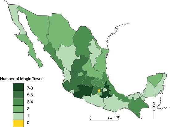
Regular readers will be well aware of our concern about the number of towns in Mexico designated Magic Towns in the past few months. As we have written previously, some of the towns chosen are far from “Magic” and offer very little indeed of interest to any regular tourist.

Not content with devaluing the program by some dubious choices, at the end of November 2012, the outgoing administration of President Felipe Calderón rushed through the designation of no fewer than 17 more towns in its last few days in office, to bring the total number of Magic Towns to 83.

Added to the list at the end of November 2012 were:

  • 67   Tacámbaro, Michoacán
  • 68    Calvillo  Aguascalientes
  • 69    Nochistlán, Zacatecas
  • 70    Jiquilpan, Michoacán
  • 71    Tlatlauquitepec, Puebla
  • 72    Tzintzuntzan, Michoacán
  • 73    Mapimí, Durango
  • 74    Papantla, Veracruz
  • 75    Tecate, Baja California
  • 76    Arteaga, Coahuila
  • 77    Viesca, Coahuila
  • 78    Jalpa de Cánovas, Guanajuato
  • 79    Salvatierra, Guanajuato
  • 80    Yuriria, Guanajuato
  • 81     Xicotepec, Puebla
  • 82     Jala, Nayarit
  • 83     El Rosario, Sinaloa

The considerable charms of Mapimí, Durango were described in a previous post. Several of the latest towns to be included are well worthy of Magic Town status, but others are not. In future posts, we will take a closer look at some of the other towns on this list, and their relative merits for inclusion as Magic Towns. For now, we content ourselves with presenting an updated map of the distribution of Mexico’s Magic Towns, as of 1 January 2013:

Mexico's Magic Towns, as of 1 December 2012. Credit: Tony Burton / Geo-Mexico

Mexico’s Magic Towns, as of 1 December 2012. Credit: Tony Burton / Geo-Mexico

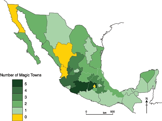
The domination of central and western Mexico is clear. All states (excluding the D.F.) now have at least one Magic Town, but southern Mexico still appears to be somewhat undervalued in terms of its cultural tourism potential.

Note: Four towns in the latest list—Tacámbaro, Jiquilpan and Tzintzuntzan (all in Michoacán) and Jala (in Nayarit)—are described in the recently published 4th (Kindle/Kobo) edition of my “Western Mexico: A Traveler’s Treasury” (Sombrero Books, 2013). The book describes no fewer than 17 of Mexico’s Magic Towns as well as several more (such as Ajijic and Bolaños) that are reported to have begun their approval process.

Related posts:

Colima Volcano erupts, destroying lava dome first created in 2007

 Mexico's geography in the Press  Comments Off on Colima Volcano erupts, destroying lava dome first created in 2007
Jan 142013
 

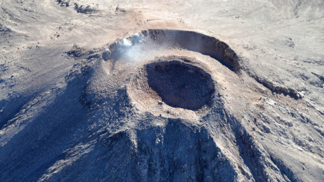
Colima Volcano (aka the Volcán de Fuego) is one of the westernmost volcanoes in Mexico’s Volcanic Axis, which straddles the country from west to east. The Volcano’s summit is only 8 km (5 miles) from the inactive Nevado of Colima volcano, Mexico’s sixth-highest peak, which rises 4260 m (13,976 ft) above sea level. (Curiously, despite their names, the summits of both volcanoes are actually located in the state of Jalisco and not the state of Colima.)

The elevation of Colima Volcano is officially given as 3820 m (12,533 ft) above sea level. In the past 400 years, it has been the most active volcano in Mexico, having erupted at least 30 times since 1576.

It is also considered to be one of the country’s most dangerous volcanoes. Numerous villages in its shadow keep a wary eye on its level of activity, and emergency evacuations have become a regular event in the past fifty years.

Colima Volcano, 11 Jan 2013. Photo: Protección Civil.

Colima Volcano forms new crater, 11 Jan 2013. Photo: Edo de Jalisco Protección Civil.

On a geological time-scale, the volcano first erupted about five million years ago in the Pliocene period, long after activity ceased at the nearby, and higher, Nevado de Colima. It quickly developed into a large volcano which partially blew apart or collapsed during Pleistocene times to form a caldera, five kilometers across. A new cone developed inside the caldera. This is the Volcán de Fuego we see today.

The cone is built mainly of pyroclastic materials (ashes and volcanic bombs) of andesitic composition together with some basaltic lava, making it a classic example of a composite volcanic cone.

Historically, the eruptions of the volcano have fallen into a definite cyclical pattern with periods of activity, each lasting about 50 years, interspersed with periods of dormancy. The first cycle of activity (after the Spanish arrived in Mexico) was between 1576 and 1611. Major eruptions occurred in 1680 and 1690, and further complete cycles occurred between 1749 and 1818, and from 1869 to 1913. Most geologists agree that current activity is part of the fifth cycle, which began in 1961.

A three year sequence of prior activity (2003 to 2005) is shown on this series of NASA satellite images.

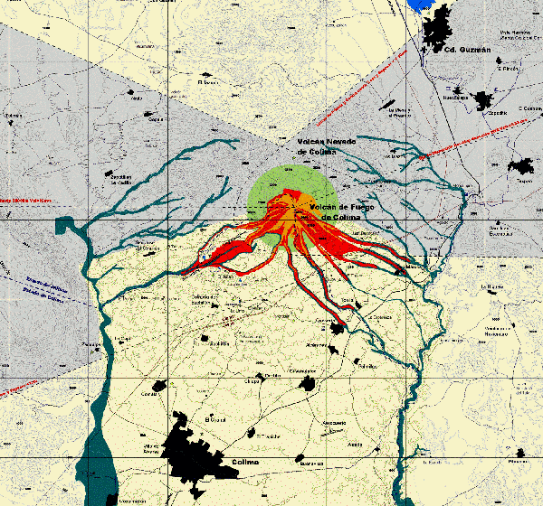
Hazard Map of Colima Volcano (2003) Credit: Universidad de Colima, Observatorio Vulcanológico

Hazard Map of Colima Volcano (2003) Credit: Universidad de Colima, Observatorio Vulcanológico. Click for full-size image (large file size)

In each major cycle, the first results of renewed activity force new lava into the existing crater, forming a dome. Once the crater has filled up, any additional lava is ejected from the crater and flows down the volcano’s flanks. If the lava is unable to escape (relieving the underground pressure), the dome is liable to explode, which is exactly what happened a few days ago:

As on several previous occasions, once the subterranean pressure that caused the activity has been relieved, activity should cease, and the volcano will enter another less dangerous dormant phase. Even during this phase, a plume of hot gas often billows out from the volcano.

The dome that was destroyed in January 2013 began to build in 2007. The explosive activity on 6 January and 10 January 2013 left behind a new crater 220 meters (720 ft) across and about 50 m (165 ft) deep. According to the Jalisco-Colima Scientific Committee (which oversees the hazard analysis posed by the volcano), the events of 6 and 10 January emitted an estimated  1.5 million cubic meters of material, which formerly formed the dome. The 10 January explosion, which occurred at 21:40 hrs local time, sent incandescent material down the west flank of the volcano. An ash column rose about 3000 meters into the air before traveling north-eastwards on the wind towards the city of Ciudad Guzmán.

Thermal imaging shortly after the 10 January explosion showed that the temperatures in the crater are below 200 degrees Centigrade, which indicates relatively little gaseous build up and limited risk of further major explosions. Even so, a prudent 7.5 km exclusion zone is being maintained around the volcano.

Update (29 Jan 2013):

Another explosion at 3:58 am on 29 January 2013 created a plume of ash and cinders that rose more than 3000 meters above the volcano. The ash fell of nearby villages, including Los Mazos, Ejido Atenquique, Tuxpan and Huescalapa.

The area around the volcanoes is described in more detail in chapter 15 of “Western Mexico, a Traveler’s Treasury” (4th edition; Sombrero Books, 2013).

Related posts:

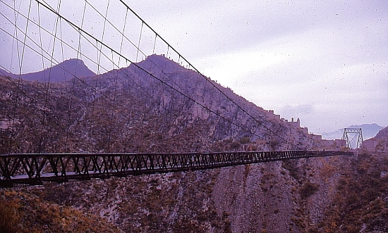
Durango gets its first Magic Town: Mapimí, along with the Ojuela suspension bridge

 Mexico's geography in the Press  Comments Off on Durango gets its first Magic Town: Mapimí, along with the Ojuela suspension bridge
Dec 082012
 

The state of Durango state finally has its first Magic Town. The small and historic town of Mapimí served various local mines, including San Vicente, Socavón, Sta. Rita, Sta. María, El Carmen, La Soledad, and the presumably traitorous Judas.

The indigenous Tepehuan Indians called this place “the rock on the hill” and repeatedly thwarted the attempts of Jesuit missionaries to found a town here, but the thirst for gold won in the end. It is rumored that gold was even found under the town’s streets. A small museum houses mementos and photos from the old days showing just how prosperous this mining town once was. One handbook to gem collecting in Mexico describes Mapimí as the “mineral collector’s capital of Mexico”. This is the place for the geologist in the group to find plenty of inexpensive agates, selenite crystals, calcite and other minerals.

Like seemingly every town in this region of Mexico, Mapimí boasts that both Miguel Hidalgo, the Father of Mexican Independence, and Benito Juárez, the President of Indian blood, passed by in the nineteenth century. Juárez even stayed overnight.

Ojuela Suspension Bridge

Ojuela Suspension Bridge. Photo: Tony Burton; all rights reserved

Access to one of the local mining areas, about 10 km outside the town is via the Ojuela suspension bridge, a masterpiece of engineering. Ruined stone houses on the hillsides tell of Ojuela’s former wealth. Ore was first discovered here in 1598. By 1777, seven haciendas de beneficio (enrichment plants) served thirteen different mines. In 1848, the Spanish mine owners gave up their struggle to make the mines pay and a Mexican company took over. In 1892 they decided to attack the hillside opposite Ojuela. To shortcut the approach, engineer Santiago Minguin spanned the gorge with a 315-meter-long suspension bridge, said by some to be the third longest in Latin America.

The mine’s production peaked just after the Mexican Revolution. Between 1922 and 1925, 687 kilograms of gold and 99,820 kilos of silver were extracted, alongside more than 51 million kilos of lead and a million kilos of copper. At that time, some 3000 miners celebrated every evening in the bars of Ojuela, now completely abandoned to the elements.

The bridge, restored for its centenary, is a worthy contribution to tourism in Durango state. One and a half meters wide, it sways and bounces in the breeze, probably scaring mums and dads into silent concentration faster than their excited children! But the local miners and their mineral-laden donkeys rattle across the planks as if it were a highway. Once across the bridge, old timers will take you on a one kilometer walk along mine galleries (unlit except for hand-held miners’ lamps) which completely traverse the mountain to emerge into daylight on the far side.

Not far from Mapimí is the internationally-famous “Zone of Silence”, the Mapimí Biosphere Reserve, the claimed merits of which are much discussed.

Mapimí is a very worthy addition to the Magic Towns list. In a future post, we will look at the merits of  six more towns added to the list in the last days of the previous federal administration.

Related posts:

Oct 012012
 

Mexico currently has 65 Magic Towns (Pueblos Mágicos), some of which we have described in previous posts. Regular readers will know we have some reservations about the program, especially about the inclusion on the list of some places that have relatively little to attract the average tourist.

Are Magic Towns distributed evenly across the country?

The map shows the distribution of the 57 Magic Towns, by state, as of 1 October 2012. Magic Towns are clearly not evenly distributed across Mexico. Two states – the State of México and Michoacán– each have five Magic Towns, while Jalisco has four. It is no surprise that the Federal District (México D.F.) is not designated a Magic Town, but it is a surprise that there are no Magic Towns in Baja California, Durango or Nayarit. Mexcaltitán, an island town in Nayarit, was one of the first towns in Mexico to be designated a Magic Town, but had this status revoked in 2009.

Mexico's Magic Towns, by state (September 2012)

Mexico’s Magic Towns, by state (September 2012)

Southern Mexican states appear to be drastically underrepresented, especially when area of state, population and indigenous groups are taken into account.

Population density map

Mexico’s population density in 2010

Larger states (in area and/or population) would surely  be more likely to have more Magic Town candidates. However, it is clear from comparing the maps of Magic Towns and population density (above) that the number of Magic Towns does not appear to be related to either the area of states, or to their population density.

The major indigenous groups in Mexico

The major indigenous groups in Mexico

Indigenous groups are relevant because they tend to live in relatively remote areas of great natural beauty, such as the Copper Canyon region or the Huasteca, and they also exhibit many distinctive cultural traits, giving them a head-start in the race to demonstrate their attractiveness for tourism. Again, though, there is little common ground between the map of indigenous groups and the map of Magic Towns. In particular, the states of Guerrero, Oaxaca and Campeche all seem to have fewer Magic Towns than might be expected.

Voting patterns in presidential elections, 2006 and 2012

Voting patterns in presidential elections, 2006 and 2012. All rights reserved.

Even politics does not appear to help explain the distribution of Magic Towns, though it must be pointed out that the pattern of voting for presidential elections (maps) may not match the pattern of municipal voting which would be more relevant to applications for Magic Town status.

If and when more towns are added to the Magic Towns list, perhaps the reasons for their distribution will become more obvious.

This post examined the distribution of Mexico’s Magic Towns, as of 1 October 2012, at which point there were only 57 in total. Since this post was written, additional Magic Towns include:

There is no doubt that Mexico has many other places that would be very worthy additions to the list. Which places would you add?

Related posts:

The geography of tequila: trends and issues

 Other  Comments Off on The geography of tequila: trends and issues
Sep 152012
 

The production and export of tequila has been one of Mexico’s major agro-industrial success stories of recent times. In this post, we look at some of the related trends and issues.

Rapid rise in production

For the period 2009-2011, Mexico produced about 250 million liters of tequila a year. Of this total, 60% was “100% agave tequila“, where all the sugars are directly derived from the Agave tequilana weber azul, and the remaining 40% was “mixed tequila” (tequila mixto) where at least 51% of the sugars are from Agave tequilana weber azul, but the remaining sugars come from other non-agave sources.

Tequila production, 1995-2011. Data: Tequila Regulatory Council.

Tequila production, 1995-2011. Data: Tequila Regulatory Council.

This is a dramatic increase compared to the period 2001-2003, when the average production was about 140 million liters a year. During that period, 100% agave tequila contributed only about 20% of the total. The relative importance of 100% agave tequila has clearly increased very rapidly in the past decade.

Agave supply: from shortage to glut

While there is a clear upward trend in total production, there are periods where production has fallen, most recently from 2008 to 2009, when production fell by 60 million liters. One of the possible reasons for a short-term blip in tequila production is if there is a shortage of agave. Agaves take about 10 years to mature, so there is a lengthy time lag between planting and the first harvest of newly planted areas.

As demand for tequila has risen, some of the major producers have experienced temporary shortfalls and been unable to source as much agave as they would have liked. One of the consequences was that independent agave producers entered the market, seeking to profit from such periods. Such independent producers could do well, provided they were able to predict agave shortages a decade in advance. During the 1990s, hillsides all over Jalisco were planted with agave, many for the first time, providing a significant boost to agave supply a decade later.

Not all independents came out of this on top. The supply of agave now exceeds demand. Many of the major tequila companies have increased their own acreage of agave, or have signed forward-looking contracts with major independent growers in other areas of the designation of origin zone. Many independent agave farmers are losing out; they planted agave a decade ago, but failed to forecast the current glut.

Tequila makers currently consume about 1 million metric tons of agave a year. The Agriculture Secretariat estimates that there are about 20,000 independent growers who have no contracts, and 223 million agave plants of diverse ages for which there is no current or short-term market. As many as 30 million agave plants were considered “very mature” in 2009 and a total loss in 2010. It is likely to be several years before the production of agave falls back to a level sustainable with demand.

Exports continue to rise

Tequila exports have risen very rapidly since 2001, with only minor anomalies along the way. Mexico currently exports about 160 million liters a year. Tequila exports have performed well despite the now lengthy economic woes being experienced by the major importing countries.

Foreign ownership

Mexico’s tequila makers have undergone a similar experience to the country’s major brewing companies, in that all but one of the major tequila firms are now owned by foreign corporations. A proposed deal in which the last of the big Mexican tequila companies, José Cuervo, would also have been taken over by British firm Diageo (which owns Baileys, Johnnie Walker, J&B, Smirnoff, Captain Morgan and Guinness) was called off in December 2012.

Environmental concern

The major environmental problem associated with tequila making is wastewater. For every liter of tequila, 10 liters of wastewater (vinazas) are produced. The vinazas are nitrogen-rich, and contain high concentrations of chemicals, including heavy metals and salt.

The National Chamber of the Tequila Industry recognizes that only about 60% of vinazas are disposed of properly. Most of the remaining 40% (about 2.5 billion liters in 2008) are thought to be pumped untreated into local streams and ponds, damaging the ecosystem and destroying stream life.

The Mexican government fines distilleries that do not have adequate treatment plants for the vinazas they produce, but in the past many companies have opted to pay the fines rather than solve the problem at source.

The vinazas problem was one of the reasons why UNESCO recently considered revoking the Tequila region’s World Heritage status, awarded in 2006. Another issue that made UNESCO unhappy was a recent decision to locate a landfill site in Amatitán in the center of the World Heritage zone. In the end, UNESCO officials agreed that progress was being made; the area kept its heritage status.

There is hope on the horizon. A new cost-effective option for tequila firms seeking to dispose of viñazas has been developed by a local corporation Tecnología Nacional de Aguas. Called Proshiemex, it uses the viñazas to produce methane-rich biogas which can contribute to heating the boilers of the tequila distilleries. The remaining sludge can be easily treated in accordance with all applicable environmental norms.

Source of data:

  • Tequila Regulatory Council Statistics

Related posts:

Protecting Mexico’s endangered marine turtles

 Updates to Geo-Mexico  Comments Off on Protecting Mexico’s endangered marine turtles
Sep 062012
 

Mexico is home to six of the world’s seven species of marine turtles, all of which are on the international Red List of endangered or critically endangered species.

The beaches along Mexico’s Pacific coast, those in the north-east state of Tamaulipas, and those in Quintana Roo on the Caribbean, are among the world’s most important breeding grounds for marine turtles. These turtles spend almost all their life at sea, but mature females come ashore in late summer and fall to burrow into the warm sand and lay their eggs.

On the Pacific coast, it is estimated that about 40% of these eggs will be stolen by wildlife poachers. When the remaining eggs eventually hatch six to eight weeks later, the baby turtles then stagger towards the relative safety of the ocean, hoping to avoid not only human poachers, but also predators such as crabs, iguanas and birds. Less than one in one hundred hatchlings will survive the fifteen or twenty years required to reach maturity.

The three turtle species most commonly found along the Pacific coast are the Olive Ridley or golfina (Lepidochelys olivacea), the Leatherback or laúd (Dermochelys coriacea) and the Green Turtle or tortuga verde (Chelonia mydas).

The Olive Ridley is relatively small in size with a narrow head. Its numbers are now recovering on the Nayarit and Jalisco coasts. Important nesting sites for the Olive Ridley include Caleta de Campos and Ixtapilla (both in Michoacán), and Playa de Escobilla and Morro Ayuta (both in Oaxaca). About 23.3 million baby turtles were born in the 1.2 million Olive Ridley nests recorded in the 2010-2011 turtle nesting season.

Leatherbacks, the world’s largest turtles, undergo amazing migrations, regularly crossing from one side of the Pacific to the other. Their numbers are in serious decliine. In 2010-2011, 15,400 baby Leatherbacks emerged from the 615 nests recorded. (Mexico is thought to have about 1,600 Leatherback nests in total.) Important nesting sites include beaches in Guerrero, Michoacán and Oaxaca. However, in the last-named state, the number of eggs laid has declined by about 20% a year over the last decade.

Selected marine turtle nesting beaches in Mexico.

Selected marine turtle nesting beaches in Mexico. Copyright 2012 Geo-Mexico; all rights reserved.

Green Turtles are an endemic species and their preferred nesting sites include Colola in Michaocán.

The three remaining species are the Kemp’s Ridley or lora (Lepidochelys kempii), the Loggerhead or caguama (Caretta caretta) and the Hawksbill or carey (Eretmochelys imbricata).

The Kemp’s Ridley is an endemic species and the only marine turtle to nest exclusively during daytime. Its most important nesting site is Rancho Nuevo, in Tamaulipas. While the numbers of Kemp’s Ridley at Rancho Nuevo fell from an estimated 40,000 or so in 1947 to about 5,000, this species appears to be well on its way to recovery. In 2010-2011, 20,574 Kemp’s Ridley nests were laid in Tamaulipas and an additional 534 in Veracruz, which produced a combined 18.9 million hatchlings.

The Loggerhead is found on both sides of Mexico, while the Hawksbill, smaller than the other species, is most common on Mexico’s Caribbean coast, though it can also be found, much more rarely, on the Gulf and Pacific coasts.

Mexico’s first turtle management program was launched in 1962. In 1990, the government enacted a total ban on the trafficking of all turtles, turtle products and byproducts. Even so, illegal poaching  (for meat, eggs or shell) continues to be a problem, especially since successful convictions relating to the capture or trafficking of turtles are rare. It is still possible to buy baby turtles (for pets) and turtle eggs (thought to be an aphrodisiac) on the black market.

The most successful strategy to date has been the establishment (since the early 1970s) of turtle protection camps on key beaches. During the egg-laying and hatching season conservation groups led by biologists, with the assistance of volunteers, local fishermen and Mexican navy personnel, guard the nesting sites, sometimes moving nests to better protected areas. This strategy has definitely been successful. For example, over the past few years, the conservation group patrolling San Francisco beach has seen the number of active Olive Ridley nests increase tenfold to 700. However, not all beaches can be protected. In Jalisco, for example, only about 80 km of the state’s 200 km of sandy shores are closely monitored.

Protection efforts at 33 nesting beaches are overseen by the National Commission on Natural Protected Areas (Conanp). Of these 33 beaches, 10 are natural protected areas, 3 are in biosphere reserves and 15 are internationally-designated Ramsar wetlands; the remaining 5 have no formal protection status.

Besides the threat from wildlife poachers and predators, marine turtles face numerous other long-term threats, including:

  • habitat destruction, when beaches are cleared for tourist development
  • the installation of coastal infrastructure, designed to prevent erosion, which may limit turtle access to beaches
  • hurricane damage destroying nests
  • the accidental bycatch of turtles by commercial fishermen
  • artificial lighting which may disorientate hatchlings who head towards the light assuming it is reflected off the ocean
  • ocean contamination by items as mundane as plastic bags, which may be mistaken for jelly fish, a favorite food of Leatherbacks

Further reading (Spanish language):

  • Programa de acción para la conservación de la especie Tortuga Laúd (Dermochelys coriacea)
  • Programa de Monitoreo de la Tortuga Golfina (Lepidochelys olivacea) en el Parque Nacional Lagunas de Chacahua

Related posts:


Sep 012012
 

Tequila is made by distilling the juice of certain species of agave plants. Agaves are commonly called “century plants” in the USA, a name derived from the length of time they supposedly grow before producing a flowering stalk – actually, from eight to twenty years depending on the species, rather than the hundred suggested by their common name! Some species flower only once and die shortly afterwards, others can flower almost every year. Agaves are no relation botanically to cacti, even though they are often mistakenly associated with them. The ideal agave for tequila is the Agave tequilana Weber azul which has bluish-colored leaves.
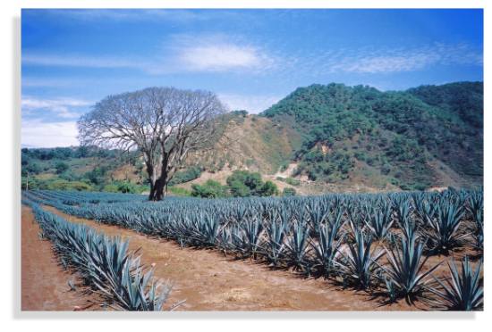
Agave field in Jalisco

Agave field in Jalisco. Photo: Tony Burton

The tequila agaves are started from seed or from onion-size cuttings. When the plants are mature (about 10 years later), their branches are cut off, using a long-handled knife called a coa, leaving the cabeza (or “pineapple”), which is the part used for juice extraction. Cabezas (which weigh from 10 to 120 kilos) are cut in half, and then baked in stone furnaces or stainless steel autoclaves for one to three days to convert their starches into sugars.

From the ovens, the now golden-brown cabezas are shredded and placed in mills which extract the juices or mosto. The mixture is allowed to ferment for several days, then two distillations are performed to extract the almost colorless white or silver tequila. The spirit’s taste depends principally on the length of fermentation. Amber (reposado) tequila results from storage in ex-brandy or wine casks made of white oak for at least two months, while golden, aged (añejo) tequila is stored in casks for at least a year, and extra-aged (extra añejo) for at least three years.

Distillation: the Filipino Connection

Mexico’s indigenous Indians knew how to produce several different drinks from agave plants, but their techniques did not include distillation, and hence, strictly speaking, they did not produce tequila. Fermented agave juice or pulque may be the oldest alcoholic drink on the continent; it is referred to in an archival Olmec text which claims that it serves as a “delight for the gods and priests”. Pulque was fermented, but not distilled.

If the indigenous peoples didn’t have distilled agave drinks, then how, when and where did distillation of agave first occur? In 1897, Carl Lumholtz, the famous Norwegian ethnologist, who spent several years living with remote Indian tribes in Mexico, found that the Huichol Indians in eastern Nayarit distilled agave juice using simple stills, but with pots which seemed to be quite unlike anything Spanish or pre-Columbian in origin.

By 1944, Henry Bruman, a University of California geographer, had documented how Filipino seamen on the Manila Galleon had brought similar stills to western Mexico, for making coconut brandy, during the late sixteenth century.

Dr. Nyle Walton, of the University of Florida, expanded on Bruman’s work, showing how the Spanish authorities had sought to suppress Mexican liquor production because it threatened to compete with Spanish brandy. This suppression led to the establishment of illicit distilling in many remote areas including parts of Colima and Jalisco. Even today, the word “tuba”, which means “coconut wine” in the Filipino Tagalog language, is used in Jalisco for mezcal wine before it is distilled for tequila. This is probably because the first stills used for mezcal distillation were Filipino in origin.

“Appelacion Controlée”

Though colonial authorities tried to suppress illegal liquors, the industry of illicit distilling clearly thrived. One eighteenth century source lists more than 81 different mixtures, including some truly fearsome-sounding concoctions such as “cock’s eye”, “rabbit’s blood”, “bone-breaker” and “excommunication”! By the 1670s, the authorities saw the wisdom of taxing, rather than prohibiting, liquor production.

For centuries, distilled agave juice was known as mezcal or vino de mezcal “mezcal wine”). It is believed that the first foreigner to sample it was a Spanish medic, Gerónimo Hernández, in the year 1651. The original method for producing mezcal used clay ovens and pots.

By the end of the nineteenth century, as the railroads expanded, the reputation of Tequila spread further afield; this is when the vino de mezcal produced in Tequila became so popular that people began calling it simply “tequila”. When the Mexican Revolution began in 1910, it swept away a preference for everything European and brought nationally-made tequila to the fore. Tequila quickly became Mexico’s national drink. It gained prominence north of the border during the second world war, when the USA could no longer enjoy a guaranteed supply of European liquors.

To qualify as genuine tequila, the drink has to be made in the state of Jalisco or in certain specific areas of the states of Nayarit, Guanajuato, Michoacán and Tamaulipas. (We will take a closer look at this distribution in a future post).

The ideal growing conditions are found in semiarid areas where temperatures average about 20 degrees Centigrade, with little variation, and where rainfall averages 1000 mm/yr. In Jalisco, this means that areas at an elevation of about 1,500 meters above sea level are favored. Agaves prefer well-drained soils such as the permeable loams derived from the iron-rich volcanic rocks in Mexico’s Volcanic Axis.

Production of tequila has tripled within the last 15 years to about 250 million liters a year (2010). About 65% of this quantity is exported. Almost 80% of exports are to the USA, with most of the remainder destined for Canada and Europe.

Connoisseurs argue long and loud as to which is the better product, but all agree that the best of the best is made from 100% Agave tequilana Weber azul. I’m no connoisseur, but my personal favorite is Tequila Herradura, manufactured in Amatitán, a town between Tequila and Guadalajara. Anyone interested in the history of tequila will enjoy a visit to Herradura’s old hacienda “San José del Refugio” in Amatitán, where tequila has been made for well over a century. The factory is a working museum with mule-operated mills, and primitive distillation ovens, fueled by the bagasse of the maguey. The Great House is classic in style, with a wide entrance stairway and a first floor balustrade the full width of the building.

Visitors to the town of Tequila, with its National Tequila Museum, can  enter any one of several tequila factories to watch the processing and taste a sample. They can also admire one of the few public monuments to liquor anywhere in the world – a fountain which has water emerging from a stone bottle supported in an agave plant. “Tequila tourism” is growing in popularity. Special trains, such as “The Tequila Express” run on weekends from the nearby city of Guadalajara to Amatitán, and regular bus tours visit the growing areas and tequila distilleries. The town of Tequila holds an annual Tequila Fair during the first half of December to celebrate its famous beverage. Another good time to visit is on 24 July, National Tequila Day in the USA.

In 2006, UNESCO awarded World Heritage status to the agave landscape and old tequila-making facilities in Amatitán, Arenal and Tequila (Jalisco).

Related posts:

How were the canyons in the Copper Canyon region formed?

 Other  Comments Off on How were the canyons in the Copper Canyon region formed?
Aug 062012
 

According to a local Tarahumara Indian legend, the canyons were formed when “a giant walked around and the ground cracked.” However, geologists believe that a sequence of volcanic rocks varying in age from 30 to 135 million years was slowly uplifted to an average elevation of 2275 m (7500 ft) while being dissected by rivers.

Mexico's Copper Canyon

Where did the rocks come from?

The Sierra Tarahumara is part of the Western Sierra Madre, an extensive volcanic tableland, affected by grabens (rift‑valley faulting) and faults which deprive it, especially on its flanks, of any homogeneous appearance. Its eastern side merges gradually into the Chihuahua basin and range landscape; its western side is much steeper, marked by major normal faults of considerable vertical extent, and by deep canyons.

Stage 1. The lower rocks.

McDowell and Clabaugh (1979) describe two different igneous sequences, which were separated in time by a prolonged period of non‑activity. The older series is mainly comprised of intermediate igneous rocks between 100 and 45 million years old; it shows evidence of lava flows and violent eruptive activity which produced andesitic pyroclasts. There are also layers of siliceous ignimbrites. This lower series includes many rich mineral deposits, though it outcrops in only restricted parts of the Canyon system. The volcanic activity in this area was associated with the subduction of the small (now destroyed) Farallon Plate which was pushed beneath the North American Plate by the expanding Pacific Plate. The line between the lower, older series and the higher, newer one is very irregular, indicating intensive erosional activity in the period between their times of formation.

Stage 2. A break in activity allowing erosion to take place.

The major lull in volcanic action, between 45 and 34 million years ago, may have been due to a change in the inclination of the subducting Farallon plate.

Stage 3. The upper rocks.

After this break in activity, there was a sudden resumption of vulcanism. The upper series is the most extensive cover of ignimbrite known anywhere in the world, covering an area which is 250 km wide, and 1200 km long from NW to SE. It stretches as far north as the southern USA. To the south, it disappears beneath the newer volcanic rocks of Mexico’s Volcanic Axis in Jalisco and Michoacán. The ignimbrites are rhyolitic and rhyo‑dacitic in composition, generally approximately horizontal, or slightly tilted, and with ages between 34 and 27 million years. In places, these ignimbrites are more than 1000 m thick (Demant & Robin, 1965).

It is unclear precisely where all these volcanic rocks originated. One estimate is that for such large volumes of rock to have been formed, there would have been between 200 and 400 volcanic outlets, some up to 40 km across. An alternative hypothesis (proposed by Aguirre-Díaz & Labarthe-Hernández) is that large bodies of magma (molten rock underground) reached shallow parts of the crust and then partially erupted, explosively, along the fault lines of the existing basin and range structures.

The common rock types in the Copper Canyon region

Volcanic Ash is unconsolidated fragments <2 mm in diameter. Volcanic ash commonly contains larger (up to 64 mm) fragments called lapilli. Ash may be composed of crystalline rock (eg. rhyolitic and andesitic ashes), of glassy fragments (vitric ash), or of individual crystals (crystal ash). In general, the size of individual particles comprising the ash diminishes as distance increases from the volcano where it originated.

Tuff is consolidated volcanic ash.

Ignimbrites are essentially pieces of light, vesicular, pumice, in a matrix of glassy fragments. Ignimbrites are often layered and sometimes split into vertical columns. They are deposited from ash flows that included large volumes of hot, expanding gases and incandescent glass fragments.

Lavas (molten rock on the surface). When lava cools and solidifies, it produces massive (as opposed to fragmentary) rocks, generally crystalline but of variable chemical composition (andesite, rhyolite, basalt).

The major landforms of the Copper Canyon region

These layers of igneous rocks were uplifted, forming a plateau with an average elevation of 2275 m (almost 7500 feet). Rivers have carved deep gashes, up to 1400 m deep, into the plateau surface, forming a series of steep-walled canyons, separated by giant blocks, remnants of the original, continuous plateau.

Incised meanders near Umira, Chihuahua

Incised meanders near Umira, Chihuahua

Since some of the rivers exhibit superb examples of incised meanders [see photo], some, possibly most, of these rivers already existed prior to the main periods of uplift. They were meandering across a gently sloping flood plain prior to the tectonic upheavals. Then, as the landscape slowly rose around them, they carved these giant canyons. These antecedent rivers retained their courses; the meanders were incised into the landscape.

Centuries of erosion by the various rivers, including the Urique river and its tributaries, have resulted in the present-day landscape of structurally-guided plateau remnants, termed mesas, buttes and pinnacles (depending on their size). There are many examples of these distinctive landforms in the Copper Canyon region.

Landforms resulting from dissection of a plateau

Landforms resulting from the dissection of a plateau

It is likely that some of the many waterfalls in the region were formed in places where the downward vertical erosion of rivers was insufficiently powerful to counteract the forces of uplift. Other waterfalls are more likely to have resulted from differences in the relative resistance of different rocks. The effects of differential erosion are noticeable in many smaller-scale features in this landscape, such as perched “mushroom” rocks.

Perched block near San Ignacio

Perched block near San Ignacio. Photo: Tony Burton; all rights reserved

Examples of many of these landforms can be seen by anyone driving along the Creel-Batopilas road. At km 5 (from Creel) is the entrance to the Mission village of San Ignacio, near which are strange tor‑like rock formations, including “mushroom” rocks, where a more resistant capstone sits perched atop weaker rocks that are slowly being eroded away.  At km 20 in  Cusárare, a short walk south of the road through woods and along the Cusárare river leads to the very pretty 30-metre high Cusárare waterfall. At km 44 (Basihuare), there are fine views of a mesa of pink and white rocks that overlooks the road. This is Cerro el Pastel (“Cake Mountain”) with its pinnacles. At km 56, near  Umirá (or Humirá) are several spectacular incised meanders formed when the river’s course was preserved while the surrounding land was undergoing relatively rapid uplift.

Small wonder that the Copper Canyon region is one of Mexico’s most important geomorphosites!

Sources:

  1. Aguirre-Díaz, Gerardo J. & Guillermo Labarthe-Hernández. 2003. Fissure ignimbrites: Fissure-source origin for voluminous ignimbrites of the Sierra Madre Occidental and its relationship with Basin and Range faulting. Geology September, 2003 v. 31, no. 9, p. 773-776
  2. Gajdusek, D.C. (1953) “The Sierra Tarahumara” in Geographical Review, New York. 43: 15‑38
  3. Demant, A & Robin, C (1975) “Las Fases del vulcanismo en Mexico” Revista Instituto de Geologia, UNAM, Mexico City. 75 (1) pp 70‑83
  4. Schmidt, R.H. (1973) A Geographical Survey of Chihuahua, monograph #37 Texas Western Press.
  5. McDowell, F.W. & Clabaugh, S.E. (1979) “Ignimbrites of the Sierra Madre Occidental and their relation to the tectonic history of western Mexico” in “Ash flow tuffs” edited by Chapin, C.E. & Elston, W.E., Geol. Soc. of America special paper # 180.

Related posts:

Jul 122012
 

An earlier post discussed the north-south divide apparent in the 2006 presidential election. That year Felipe Calderón of PAN got the most votes in 14 of 17 northern states (blue on the map), while in 13 of 15 southern states Andrés López Obrador of PRD (green) got the most votes. Roberto Madrazo of PRI (pink) did not get the most votes in a single state.

Voting patterns in presidential elections, 2006 and 2012

Voting patterns in presidential elections, 2006 and 2012. All rights reserved.

The voting pattern changed considerably in the 2012 presidential election, but a north-south pattern still emerged. What was somewhat similar in both elections is that López Obrador of PRD retained much of his strength in southern Mexico. In both elections, PRD got most votes in seven southern states: Federal District, Morelos, Tlaxcala, Guerrero, Oaxaca, Tabasco and Quintana Roo. In 2012 PRD won in one other state, Puebla, which favored PAN in the 2006 election. Six southern states switched from PRD to PRI:  Michoacán, México, Hidalgo, Veracruz, Chiapas and Campeche. Puebla switched from PAN to PRD, while Yucatán went from PAN to PRI.

In the north, the pattern changed completely with the PRI replacing PAN as the highest presidential vote-getter. A total of 11 northern states switched from PAN to PRI: Baja California, Sonora, Chihuahua, Coahuila, Sinaloa, Durango, Aguascalientes, San Luis Potosí, Jalisco, Colima and Querétaro. In 10 of these states PAN came second while PRD took second place in Baja California. In 2012 PAN got most votes in only three states–Nuevo León, Tamaulipas and Guanajuato–compared to 16 in 2006.

PRD appears to have lost much of its relatively weak following in northern Mexico. The three northern states PRD won in 2006 all switched to PRI: Baja California Sur, Nayarit and Zacatecas. In 2012, PRD could only manage second place finishes in three states: Baja California, Nayarit and Zacatecas.

While the north-south pattern is still somewhat apparent, the main pattern of the 2012 presidential election is a strong victory for PRI candidate Enrique Pena Nieto. PRI was victorious in 22 of 32 states and came in second in the other ten.

However, PRI fell just short of controlling Mexico’s Congress so it will need support from some other parties to pass needed legislation and reforms. Together with minority coalition partner PVEM (Mexico’s Green Party), PRI won 240 of the 500 seats in the Chamber of Deputies and 62 of the 128 seats in the Senate. On the other hand, PRI has recently indicated support for many reforms similar to those previously proposed by PAN. This implies that needed reforms may have a decent chance of passing.

Further reading, with state by state analysis:

Related posts:

Jun 072012
 

The Peña de Bernal, in the central state of Querétaro, is one of Mexico’s most distinctive geomorphosites. Geomorphosites are “landforms that have acquired a scientific, cultural/historical, aesthetic and/or social/economic value due to human perception or exploitation” (Panizza M., 2001). See Geotourism and geomorphosites in Mexico for a brief introduction to the topic.
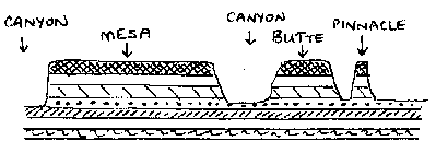
The Peña de Bernal is a dramatic sight, which only gets more imposing the closer you get. How high is the Peña de Bernal? We are unable to give you a definitive answer (it depends where you start measuring from) but claims of 350 meters (1150 feet) sound about right, assuming we start from the town.

Peña de Bernal. Photo: Tony Burton; all rights reserved

The Peña de Bernal. Photo: Tony Burton; all rights reserved.

According to its Wikipedia entry, this is the “third tallest monolith in the world”, apparently only exceeded by the Rock of Gibralter and Sugarloaf Mountain in Rio de Janeiro. Others, including Melville King, have described it as the “third largest rock in the world”. These claims may (or may not) be exaggerated, but in reality it is definitely a very steep and tiring climb, even to reach the small chapel that has been built half-way up! The photo below is taken from this chapel, looking out over Bernal and the local farmland and vineyards.

View from the Peña Bernal, with the town of Bernal in the foreground.

View from the Peña de Bernal over the small town of Bernal. Photo: Tony Burton; all rights reserved.

How was the Peña de Bernal formed?

The most likely explanation is that this monolith represents the hardened magma (molten rock) from the central vent of a former volcano. This rock was much more resistant to erosion that the layers of ash and/or lava that formed the volcano’s flanks. Centuries of erosion removed the sides, leaving the resistant core of the volcano exposed as a volcanic neck. We will examine this idea in slightly more detail in a future post.

The town of Bernal

The town of San Sebastián Bernal is also well worth visiting. Having become a magnet for New Age types, it now boasts several decent restaurants, good stores and a range of hotels including high quality “boutique” hotels. Bernal was designated one of Mexico’s “Magic Towns” in 2005. To learn more about the town of Bernal and see some fine photos, we highly recommend Jane Ammeson’s article “The magic of Bernal, Querétaro: wine, opals and historic charm.

At the Spring Equinox (March 21), the town is invaded by visitors “dressed in long, white robes or gowns, and red neckerchiefs” who come seeking “wisdom, unity, energy and new beginnings”. (Loretta Scott Miller writing in El Ojo del Lago, July 1997).

How to get there:

From Mexico City, take the Querétaro highway (Hwy 57D) north-west to San Juan del Río. Then take Highway 120 past Tequisquiapan as far as the small cross-roads town of Ezequiel Montes. Turn left for about 11 kilometers, then right… and you’re there! Taking this route gives you glimpses of the Peña de Bernal from afar. Allow 2.0 to 2.5 hours for the drive.

Other geomorphosites worth visiting:

Mexico has literally thousands of geomorphosites. Among those described in previous posts are:
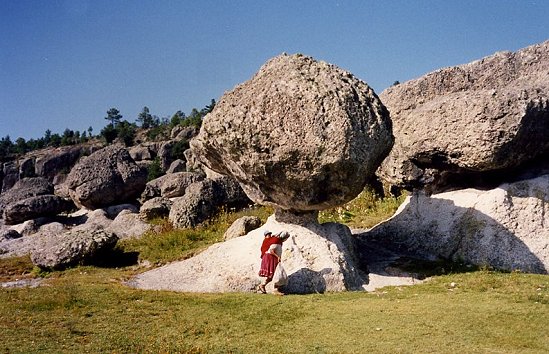
 

How does Mexico’s electoral process compare to other countries?

 Other  Comments Off on How does Mexico’s electoral process compare to other countries?
May 232012
 

On 1 July 2012 Mexicans go to the polls to elect a new six year president, a new senate and chamber of deputies. At the same time, voters in some states–Jalisco, Nuevo León, Guanajuato, Querétaro, Sonora, San Luis Potosí, Morelos, Federal District, Campeche and Colima– will cast their ballots in elections for state and local officials.
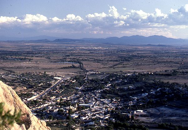
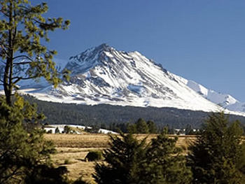
How free and fair are Mexican elections compared to those in other countries?

Before addressing this question, it is useful to acknowledge that elections in Mexico have improved dramatically in the past two decades, largely as a result of progressive reforms including the establishment of a strong and independent National Elections Commission (Instituto Federal Electoral, IFE). Prior to the late 1990’s one party, PRI (Partido Revolucionario Insititucional, Institutional Revolutionary Party) dominated most elections at the national, state and local level. Starting in 2000, when an opposition party, PAN (PAN or Partido Acción Nacional, National Action Party), won the presidency, elections in Mexico have been quite competitive. In 2006 a third party, PRD (Partido de la Revolución Democrática, Party of the Democratic Revolution), lost the presidency to PAN by less than 0.6% (35.89% to 35.31%). Since 1994 the winner of the presidency has not garnered 50% of the votes, leading some to argue that Mexico should conduct runoffs between the two highest vote-getters.

CountryScoreCountryScoreCountryScore
Uruguay10.00Peru9.17Turkey7.92
Canada9.58MEXICO8.75Indonesia6.92
Chile9.58Argentina8.75Venezuela5.67
India9.58Israel8.75Nigeria5.67
Brazil9.58South Africa8.75Russia3.92
USA9.17Guatemala7.92China0.00
Colombia9.17

The Economist Intelligence Unit (EIU) annually develops a “democracy index” which includes a factor titled “electoral process and pluralism”. Scores on this factor are based on 12 questions concerning the conduct of free, fair and transparent elections open to all groups and all voters as well as the orderly transfer of power to those winning elections. Based on the EIU scores for 2011, countries with the perfect score of ten were Uruguay, Norway, Iceland, Denmark, Finland, Luxembourg, Australia and New Zealand. Mexico is tied with Argentina, Israel and South Africa, trails Chile, Brazil, Colombia and Peru but is much closer to the top than the bottom (see table). Mexico is a point and a quarter below a perfect ten and almost a point ahead of Guatemala, three ahead of Venezuela and almost five ahead of Russia. China is last with a score of zero along with Saudi Arabia, Ethiopia, North Korea, and other authoritarian regimes.

It will be interesting to see how the EIU scores Mexico after the 2012 elections.

 Related posts:


Mexico’s highest volcanoes

 Excerpts from Geo-Mexico  Comments Off on Mexico’s highest volcanoes
Apr 302012
 

In a previous post, we saw how most of Mexico’s volcanoes are located in a broad band that crosses central Mexico known as the Volcanic Axis (Eje neovolcánico). In this post, we provide brief descriptions of some of the major volcanoes in Mexico.

Starting in the west, the first active volcanoes are Everman and Barcenas in the Revillagigedo Islands. Two of the westernmost volcanoes on the mainland are near Colima. At 4260 m (13,976 ft), the inactive Nevado of Colima, Mexico’s sixth-highest peak, is as tall as the highest mountains in the contiguous USA. Its younger brother, Colima Volcano (or Volcán de Fuego) is lower (3820 m) but highly active and considered potentially very dangerous. It has erupted in cycles for several hundred years, and is capped by a dacitic plug characteristic of a silica-rich Pelean volcano. Such volcanoes have the potential to erupt suddenly, not emitting vast quantities of molten lava, but shooting out less spectacular, but far more devastating, clouds of red‑hot asphyxiating gasses.

Tequila Volcano, overlooking the town where the beverage is distilled, is also in Jalisco. In neighboring Michoacán state, the most noteworthy volcanoes are Jorullo (which last erupted in 1759) and Paricutín, which began life in a farmer’s field in 1943 and ceased activity in 1952, but only after its lava had overwhelmed several small villages.

Closer to Mexico City, the Nevado of Toluca (4680 m) has a drive-in crater and is a favored destination for Mexico City families in winter to take their children to play in the snow. It is Mexico’s fourth highest peak (see table below).

VolcanoStatesHeight (meters)Height (feet)
Pico de OrizabaVeracruz; Puebla5 61018 406
PopocatapetlMéxico; Morelos; Puebla5 50018 045
IztaccihuatlMéxico; Puebla5 22017 126
Nevado of Toluca México 4 68015 354
MalincheTlaxcala; Puebla4 42014 501
Nevado of Colima Jalisco4 26013 976
Cofre de PeroteVeracruz 4 20013 780
TacanáChiapas 4 08013 386
TelapónMéxico 4 06013 320
El AjuscoFederal District3 93012 894
Colima VolcanoJalisco; Colima3 82012 533

Continuing eastwards, we reach several other volcanoes that are among Mexico’s highest volcanic peaks (and are also included in the table).

The most famous volcano in the Volcanic Axis is the still active Popocatepetl (“Popo”), which rises to 5500 meters (18,045 feet). Alongside Popocatepetl is the dormant volcanic peak of Iztaccihuatl (5220 m or 17,126 ft). On a smog-free day, both are clearly visible from Mexico City. The southern suburbs of Mexico City are overshadowed by a smaller active volcano, Ajusco, which reaches 3930 m (12,894 ft).

The Nevado de Toluca volcano

The Pico de Orizaba, a dormant volcano on the border between states of Veracruz and Puebla, is Mexico’s highest mountain. At 5610 m (18,406 ft) it is the third highest peak in North America. By way of contrast, not very far away, in the outskirts of the city of Puebla, is the world’s smallest volcano!

Only a few volcanoes appear to be located outside the Volcanic Axis and therefore in an anomalous location to the general pattern. They include two volcanoes in Chiapas which lie south of the Volcanic Axis: El Chichón (which erupted in 1982) and Tacaná (4080 m).

Related posts: