indigenous population | Geo-Mexico, the geography of Mexico - Part 2

Video documentation of the Lacondon Indians in Chiapas

 Books and resources  Comments Off on Video documentation of the Lacondon Indians in Chiapas
Jan 162015
 

The Lacondon Maya are one of the most isolated and culturally conservative of Mexico’s numerous indigenous peoples. Their homeland is in the remote Lacondon Jungle in eastern Chiapas, close to the Guatemalan border. The Lacondon were the only Mayan people not conquered or converted by the Spanish during the colonial era. Until the mid-20th century they had little contact with the outside world, while maintaining a sustainable agricultural system and practising ancient Mayan customs and religion.

This short two-part video by Joel Kimmel (Part One above; Part Two below) briefly traces the history of the Lacandon back to the classic Mayan civilization. The videos document their successful, slash and burn, rotating, multicrop, subsistence agricultural lifestyle, steeped in religious ritual, and sustained over centuries in small isolated groups in the almost impenetrable Lacandon jungle.


The film then looks at the more recent outside influences that resulted in the near extinction of the Lacandon by the mid 20th century. Today their population has increased again and is estimated at between 650 and 1000, living in about a dozen villages. The second video focuses on the Lacondon’s confrontation with the modern world over the past four decades. One group, the “southern” Lacandon have opted for Christianity and the trappings of modern life, whilst some in the “northern” group, centered around the village of Naja, near the Mayan ruins of Palenque, attempt to maintain the old customs and religion. The video ends with the thoughts of a former Director of Development at Na Bolom, regarding the possibility, and immense difficulty, of trying to preserve what remains of their language, cultural heritage and ecological knowledge, treasures the world can ill afford to lose.

The videos introduce speakers and photos from the internationally famous Casa Na Bolom, in San Cristóbal de la Casas, Chiapas. This scientific and cultural research institute was founded in 1951 by Danish archeologist Franz Blom and his Swiss wife, Trudy Blom, journalist, photographer and later environmental activist. They devoted their lives to documenting the cultural history of the Lacondon people and life in the Chiapas jungle and advocating for the survival of both. Following Trudy Blom’s death in 1993, the Asociación Cultural Na Bolom has continued to operate the center as a museum, research and advocacy center, and tourist hotel. It houses an archive of over 50,000 photographs, and other documentation created by scholars over the decades.

The two videos provide visual proof of the forces of modern Mexico that have threatened the existence of the Lacondon way of life – government roads opening up the jungle to loggers and other settlers, logging permits resulting in massive clearcutting of the mahogany forests , the arrival of tourism, Coca-Cola and canned foods, mainstream education and modern technology like satellite television.

Not covered in the video is the fact that a Mexican presidential order in 1971 granted 614,000 acres to the Lacandon Community, recognizing their land rights over the, by then, more numerous settlers who had been allowed to colonize the Lacandon Forest under previous governments. This, however, has brought the Lacandon into conflict with many settler-groups, creating problems which continue to the present time. (See Chiapas Conflict on Wikipedia).

Related posts

The Magic Town of Tzintzuntzan in Michoacán

 Other  Comments Off on The Magic Town of Tzintzuntzan in Michoacán
Jul 262014
 

Tzintzuntzan, designated a Magic Town in 2012, has two sixteenth century churches, equally ancient olive trees, a craft market specializing in straw goods and ornaments, plus an archaeological site which was the capital of the not inconsiderable Tarascan Empire.

The Tarascan Empire

The Tarascan Empire, contemporaneous with that of the Aztecs, stretched westwards as far as the shores of Lake Chapala, with sporadic contacts into the Sayula lake area, and to the east as far as present-day Zitácuaro. The Tarascans spoke Purépecha, and today the local indigenous people prefer to be called Purépecha. The term “Tarascan” is more properly reserved for their ancestors and their pre-Columbian empire.

“Tzintzuntzan” is an onomatopoeic Purépecha rendering of the sound made by a hummingbird. The ceremonial center was still fully active when the Spanish arrived. Tarascan buildings were constructed mainly of wood. Only the basements were normally built of stone and today, therefore, it is only these basements or yácatas that remain. Some of the cut stones which cover the rubble-filled interiors of the yácatas are ornamented with rock carvings.

The scale of earth-moving involved in constructing the temples is remarkable. The entire 425-meter-long platform is man-made. On it were built five yácatas, on the tops of which would have been wooden and thatch structures serving as shrines. The semi-circular shape of these yácatas suggests that they were built to honor the god of the wind, Ik. The Tarascan ceremonial centre commands a magnificent view over the lake, whose waters would have been lapping at the platform’s base during some rainy seasons. The area behind the yácatas, next to the village soccer pitch blazes with color during the wildflower seasons of late spring and early autumn. The archaeological site has a small, modern museum.

The Tarascans had a mixed economy, collecting fruits and forest products, fishing and undertaking agriculture, complete with terracing and irrigation. Some archaeologists have argued that many of the pre-Columbian peoples, dependent on the natural world for their immediate survival, were very ecologically-conscious. However, in this area, evidence from rates of lake sedimentation now suggests that maybe they weren’t quite so environmentally-aware after all. It seems that erosion rates were already on the rise by the time the Spanish arrived, suggesting that native agriculture was almost certainly not sustainable. Following the introduction of European diseases, the decline in population (and agricultural workforce) prompted a further increase in erosion rates as soil conservation methods could not be maintained. Erosion and sedimentation were exacerbated by the nineteenth and twentieth century deforestation of surrounding hills.

Spanish churches

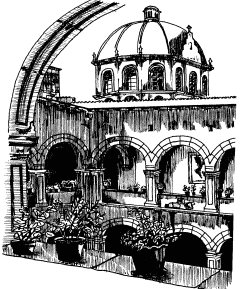
Tzintzuntzan monastery and church. Artist: Mark Eager. All rights reserved.

Tzintzuntzan monastery and church. Artist: Mark Eager. All rights reserved.

The Spanish destroyed the Tarascan temples, carting off many of the stones to build Catholic churches in their new village. Observant visitors to the beautifully-proportioned patio of the former monastery beside the main church will spot petroglyphs on some of the walls there which betray the stones’ earlier placement in the yácatas. This building, decorated with fine old colored frescoes depicting Franciscan lore, and with parts of its original wooden roof still intact, houses the office of the parish notary and is not always open to the public.

There are other peculiarities here, too, which say much for the realities of sixteenth century Spanish monastic life. When the monastery of Tzintzuntzan was built, two churches were constructed, one for the monks’ private use and the other for the lay Third Order. These two churches, only a few steps apart, are about as different as can be, given that they are of similar age. The monks’ church, beautifully restored following an arson attack, is light and airy; the Third Order church is dark, gloomy and oppressing. Both, in their own way, are awe-inspiring. To one side of the Third Order church is a complete-immersion font, shaded by two tall trees.

Ancient olive trees

In the large atrium in front of the monastery are a sixteenth century cross and the bent and twisted tree trunks of some of the oldest olive trees in Mexico, brought by special request from Spain for the express purpose of providing the monks with one of their accustomed foods. They are thought to be more than four hundred and fifty years old.

Handicraft market

Tzintzuntzan’s handicraft market is a cornucopia of straw work in every conceivable color, design and size, which make ideal Christmas decorations or gifts. Also on sale are elaborately carved wooden beams, and examples of the many different local pottery styles including the Ocumicho devil-figures and strange green pineapples as well as finely detailed, hand-embroidered scenes of village life.

How to get there:

Tzintzuntzan is about twenty minutes drive from Pátzcuaro.

Source:

This post is based on chapter 32 of my “Western Mexico: A Traveler’s Treasury” (link is to Amazon’s “Look Inside” feature), also available as either a Kindle edition or Kobo ebook.

Income inequality before and after tax

 Other  Comments Off on Income inequality before and after tax
Jul 212014
 

In several previous posts, we have explained how the GINI index can be used to quantify the degree of income inequality within a population or country. The higher the GINI index, the more inequality there is. National comparisons of inequality are usually based on working out the GINI index for countries using their residents’ gross (pre-tax) incomes. However, it is also possible to calculate the GINI index for net incomes, incomes after taxes have been taken into account.

This enables economists to assess the impact of tax systems on income distribution (and income inequality) in a country.

The graph below (Figure 2 from Brown et al, 2013) shows pre- and post-tax income GINI coefficients for a selection of countries, including the larger economies in Latin America.

gini-pre-post-taxesIn the European countries, such as Belgium and Sweden, on this chart, the GINI coefficient after tax (dark bars) is much lower than the GINI coefficient before tax (light-colored bars). This means that the taxation system has led to less income inequality than existed prior to taxation. In general terms, this means that the tax system is (overall) a progressive one [i.e. one where taxes take an increasing proportion of income as income rises].

In Latin American economies, a different picture emerges. With the exceptions of Brazil and Costa Rica, the GINI coefficients after taxes are taken into account are actually higher than the GINI coefficients before tax, meaning that income inequalities have become greater as a result of the tax system. In general terms, these tax systems are regressive [where taxes take a decreasing proportion of income as income rises].

In Brazil and Costa Rica, the levels of income inequality remain unchanged after taxation is taken into account.

Clearly, if reducing income inequality is a priority for Latin America, then something has to change. Whether a nation prefers a tax system that is regressive or progressive is a question of political beliefs and policy, as well as a question of economics.

It should be noted that the chart is based on calculations using data from 2012 or earlier. It will be interesting to see how Mexico’s recent major fiscal reforms impact its GINI coefficient in the coming years. Will the recent reforms lead to a more equitable situation and reduce the GINI coefficient, or will they foment greater inequality of income, making the rich richer and the poor poorer?

Note:

The exact methodology used to derive the post-tax GINI coefficient is not clear in the original article. In particular, it is unclear whether or not the after-tax income in the chart includes the large number of Mexican workers in the informal sector who generally do not pay any income or payroll tax.

Source of image:

“Towards financial geographies of the unbanked: international financial markets, ‘bancarization’ and access to financial services in Latin America” by Ed Brown, Francisco Castañeda, Jonathon Cloke and Peter Taylor, in The Geographical Journal, vol 179-3, September 2013, 198-210.

Related posts:

Apr 032014
 

Geo-Mexico agrees entirely with Joseph Kerski (a key member of ESRI’s Education Team), that it is amazing “how little American students really know about their neighbor to the south.” In order to help remedy this situation, ESRI’s Witold Fraczek has created a series of online “story maps” about Mexico. The maps can be accessed in several different ways, including as an ArcGIS Online presentation and an iPad iBook, or via this webpage.

The six stories are entitled:

Each “story” includes several maps (covering topics such as population, landforms, climate, historical landmarks, caves, indigenous cultures, tourist attractions), some of which are interactive in the sense that clicking on a marked point brings up a pop-up panel with a photograph and/or additional information about that place. The maps, linked by short commentary notes, can be viewed at a variety of scales.

This series of maps has many strong points, and could certainly be useful in some geography classes, but it also has some weaknesses that should be taken into account when using them. Brief comments follow on each of the six stories.

1 Explore Mexico (Crime vs. Tourism)

The first map in this mini-series depicts “tourism attraction density” based on “650 major points of interest”. No clues are offered as to how the 650 points were selected, and indeed, some can not really be shown by points on a map since they cover larger areas. The map appears to weight all 650 points equally, though some are major, major tourist attractions (like the pyramids of Teotihuacan) that attract thousands of visitors a day, while others are very much less significant.

The second map, showing the “20 cities with most murders” uses data from 2011 (now out-dated) to conclude that “crime, measured by the total number of murders” appears to be “spatially isolated from the areas most attractive to tourists”. Surely murder rates (per 100,000 people) are a better measure than the number of murders in each city?

Murder rate per 100,000 is used as the basis for comparing Mexico with its regional neighbors, but Mexico is so large (and the murder rates across the country so varied) that comparisons at this scale mean relatively little, especially when some of the nations are tiny Caribbean islands, where one or two murders extra in any year can mean a significant spike in their murder rate.

2. Mexico’s Natural Wonders

The introductory text to this section rightly highlights how “the natural world of Mexico varies amazingly, from tropical jungles and coral reefs to deserts and glaciers.”

However, the statement that “Central Mexico is home to billions of Monarch Butterflies, whose 2 year /4 generation long trip to Canada and back amazes both scientists and the general public” is misleading. First, there may be millions of Monarch Butterflies, but there are not billions. Secondly, not all Monarch Butterflies migrate. Thirdly, those that do migrate are part of an annual (1 year) cycle involving 4 or 5 generations, not a two year cycle.

The text later claims that the Monarch Butterfly reserves “are located on old volcanic hills covered with pine-oak forest”. Actually, they overwinter in pine-fir forests. Mexico’s pine-oak woodlands occur only at much lower elevations.

The only birds incorporated into Mexico’s “biological wonders” are its pink flamingos, yet there are dozens of other bird species that are equally worthy of inclusion. Fortunately, the texts accompanying the maps of caves and cenotes (sinkholes), waterfalls, volcanoes, canyons and geologic sites appear to be much more accurate.

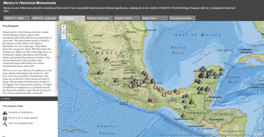
Screenshot from ESRI's story maps of Mexico.

Screenshot of ESRI’s story maps of Mexico.

3. Historical monuments

This section includes a useful map of Mexico’s World Heritage sites, though absent (from both the declared sites and the proposed sites) is the El Pinacate and Gran Desierto de Altar Biosphere Reserve in Sonora, which in June 2013 became Mexico’s 32nd World Heritage Site.

The great weakness of the maps of “archaeological sites” and “missions and monasteries” is that no clues are given as to how and why particular locations were selected for inclusion. This leads to some anomalies in the distribution. For example, Oaxaca is almost a no-show for “missions and monasteries” according to the map, despite such buildings being the subject of an excellent and extensive book by Richard Perry published as long ago as 2006, Exploring Colonial Oaxaca: The Art and Architecture.

The map of Magic Towns is also a useful map, though many more towns have been added to the list since 2012.

4. Geography of Mexico – Did You Know?

This series of maps will be quite useful to many classes as a quick way to introduce the basic physical and settlement geography of the country. Maps of relief and precipitation are accompanied by one of time zones and a simple map of states (though these are not named on the “map story” version) and major cities.

The introductory text to this section claims that “the array of Mexican volcanoes stretches along the same latitude as the volcanoes of Hawaii. Analogously, those located at the eastern ends are the newest and highest.” This may be true for Hawaii, but is not the case for Mexico. There is no simple pattern to the heights of Mexico’s major volcanoes, and certainly those in the east are not significantly younger than those in the west.

5. Indigenous People of Mexico

The single map in this section attempts to show the location of about 25 of Mexico’s many indigenous groups. The colors chosen for each group are in many cases confusingly similar, though the names of each group do appear as you zoom in on parts of the map.

The introductory text makes a strong case for Mexico’s attractiveness to tourists, yet concludes with the strange (and unanswered) question, “So why isn’t Mexico a major tourist destination?” Mexicans would beg to differ. Mexico is a major tourist destination. In 2013, for example, it received 23.7 million international visitors who spent 13.8 billion dollars. In fact, Mexico is ranked #11 in the world in terms of tourist arrivals (and that number excludes the 70 million or so border tourists each year).

6. Cartograms of Mexico

The cartograms in the last section certainly add interest to the map stories, but the basis of the “travelers attractiveness” map (those 650 tourist attractions again) means that the map is not a very good reflection of tourist numbers across the country. The significance of the State of Mexico is greatly exaggerated, while states such as Quintana Roo (with the resort of Cancún) and Baja California Sur (with Los Cabos) fail to stand out.

The final “fictional map” purports to portray Mexico as perceived by Californians. Based on the author’s personal impressions, in some ways this is the single most interesting map in the entire collection!

All in all, these maps are a mixed bag. The idea behind them is great, as is the decision to produce them in a flexible GIS system. If the details were refined a little, and more explanation offered about the basis for selecting places for inclusion, they would be even more useful in geography classes, and might go some way towards helping American students gain a better appreciation for their southern neighbor.

Extreme poverty declined between 2010 and 2012

 Other, Updates to Geo-Mexico  Comments Off on Extreme poverty declined between 2010 and 2012
Feb 012014
 

As we saw in an earlier post – Poverty on the rise in some states in Mexico – the total number of people living in poverty in Mexico continues to rise, though the poverty rate (as a percentage) remains roughly the same.

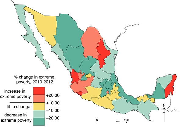
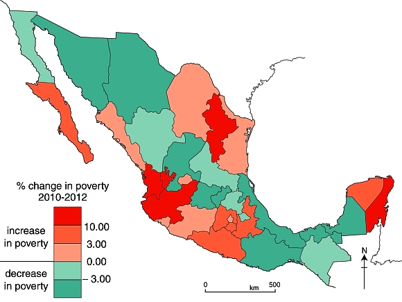
The measures of poverty used by Mexico’s National Political and Social Development Commission (Coneval) are multidimensional, and not simply based on household or personal income. This map shows the changes in “extreme multidimensional poverty” (a category that includes “the poorest of the poor”)  that occurred in Mexico between 2010 and 2012.

Changes in levels of extreme poverty in Mexico, 2010-2012.

Changes in levels of extreme poverty in Mexico, 2010-2012. Credit: Geo-Mexico; all rights reserved. Data: Coneval

In areas shaded red, a higher percentage of the population experienced “extreme poverty” in 2012 than in 2010; their personal situations and opportunities have presumably become significantly worse. Interestingly, this category includes the prosperous states of Nuevo León (economy based on manufacturing and services) and Quintana Roo (tourism).

The reverse is true for areas shaded blue where the extreme poverty rate has fallen: many of the people living in those areas have moved out of the most extreme category and presumably have seen their fortunes and opportunities improve, even if, in most cases, not sufficiently to have escaped the “poverty” category completely. This category includes more than half of Mexico’s 32 administrative divisions.

The fact that “extreme poverty” has declined in more than half of Mexico is encouraging, and suggests that government policies aimed at poverty reduction, such as Oportunidades are gradually making a difference. It remains to be seen whether or not this trend continues over the next few years.

Related posts:

Jan 162014
 

“Holiday in Mexico” is a collection of essays relating to the history of tourism in Mexico. The dozen authors involved are primarily academic historians, but also include a journalist. While the writing style is somewhat varied, this in no way detracts from the overall high quality of the contributions.

As Dina Berger and Andrew Grant Wood, the book’s editors, point out in their introduction, Mexico’s dilemma as regards tourism has always been to “reconcile market demand with a desire for national sovereignty” (p. 1). Tourism may stimulate the economy but can also have adverse environmental, social, and cultural consequences. Tourism promoters have always sought to “package” Mexico in a way that will attract tourists. The tourism sector’s portrayals of Mexico are inevitably subjective and seek to influence the perceptions of potential visitors.

The book’s 14 chapters (including the introduction) span 3 time periods:

  • 1840s-1911
  • 1920-50
  • 1960-present

and examine three main themes:

  • how Mexicans promoted and imagined their country and culture
  • the political lenses through which Mexicans and tourists have interacted with each other
  • the advantages and disadvantages of tourism

1840s to 1911

Two chapters look at the early history of tourism in Mexico. Andrea Boardman links the early days of American tourism in Mexico to the US soldiers who entered Mexico during the Mexican-American War. Among other achievements, American soldiers climbed Mexico’s highest peak, El Pico de Orizaba, though they were certainly not the first foreign nationals to do so. The accounts written by soldiers helped the American public appreciate that Mexico was worth exploring. Visiting Mexico became easier once the major railway lines had been completed at the end of the nineteenth century.

Christina Bueno offers a detailed look at the contested reconstruction of Teotihuacan, the earliest major archaeological site to be opened for tourism, its “restoration” timed to coincide with the celebrations for Mexico’s centenary of independence. Cultural and historical tourism have remained important aspects of tourism in Mexico ever since. Such tourism simultaneously stresses the significance of indigenous culture while portraying the nation as “modern” and “forward looking”.

1920-60

Five chapters of “Holiday in Mexico” look at the formative period of tourism development in Mexico that began shortly after the start of the Mexican Revolution in 1910.

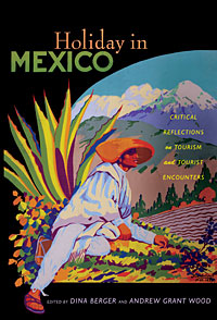
cover of holiday in mexicoAndrew Grant Wood shows how business leaders in the port of Veracruz were able to reposition the city, changing its image from an insalubrious and unsafe city into a haven for cultural activities, music and dance, centered on annual Carnival celebrations.

Dina Berger looks at tourism, diplomacy and Mexico-USA relations. Mexico’s active promotion of its national progress (such as modern highways), democracy and friendliness coincided with a period when the USA pursued its Good Neighbor policy and Panamericanism (such as the construction of the Pan American Highway).

Eric Schantz’s essay focuses on postwar tourism in Baja California’s border zone, and considers the impacts of gaming, racing, prostitution and the growing tourism entertainment industry. Many of those crossing the border to partake in these activities were, strictly speaking, “visitors” rather than “tourists”, since they remained less than 24 hours, but they had a massive influence on the economy of some border cities.

In the next chapter, “Fun in Acapulco? The Politics of Development on the Mexican Rivera,” Andrew Sackett weaves a carefully-crafted narrative that encompasses Acapulco cliff divers, Hollywood movie stars, state intervention, poor ejido farmers being dispossessed of their land, and the capriciousness of resort developers. This is possibly the strongest chapter in the book from a geographical perspective, though Sackett overstates the significance of a 1946 map of the city, since all maps are perceptual statements and necessarily simplify the landscape and select the most appropriate points of reference for their intended audience.

Lisa Pinley Covert then looks at how San Miguel de Allende’s tourist industry developed from a combination of local, national and international factors and players. In this case (unlike Acapulco) local efforts were preeminent in establishing the city’s reputation as a center for cultural tourism. Interestingly, no distinction is drawn in this chapter between the impacts of “tourists” and the impacts of the longer-term, non-tourist foreign residents that now comprise a distinctive segment of the city’s population.

1960-present

The final five chapters have greater contemporary relevance. Jeffrey Pilcher gives an engrossing account of how culinary tourism emerged, of how restauranteurs created “authentic” Mexican cuisine, a kind of “gentrification” of Mexican food. This account supports the view that cultural imperialism has not led to the food homogenization of North America, but, on the contrary, has led to varied, glocalized responses including innovatory regional and local cuisine.

M. Bianet Castellanos looks at the lesser-known face of mass tourism in the centrally-planned FONATUR resort of Cancún: the many service workers who migrated from nearby indigenous communities, and their perceptions of the resort and its tourist industry.

Adopting a national viewpoint, Mary K. Coffey examines how federal government policies in the past decade or so have sought to promote Mexico’s artistic and folk art culture as a powerful magnet for tourism. To remain competitive on the world stage, and counteract the impacts of events elsewhere (such as 9/11), Mexico’s tourism sector needs to continually reinvent itself. This is an excellent example of how changing policies and rhetoric can help keep Mexico in the world tourist spotlight.

In looking at Los Cabos, another centrally-planned resort, Alex M. Saragoza emphasizes how it was designed specifically to appeal to wealthy US tourists, hence its emphasis on golf courses, and its grandiose plans (now scaled-back) for the “Escalera Náutica”, a network of marina resorts.

The final essay, by travel writer Barbara Kastelein, looks at some of the forces behind the development of tourism in three contrasting locales: Acapulco, Oaxaca and Amecameca, considering some of the broader aspects including race, gender, and class dynamics.

The geographical coverage of “Holiday in Mexico” is quite broad but certainly not comprehensive. The use of case studies allows the authors to explore the many subtexts in depth, but it may be that some of the insights arrived at fail to hold up when a regional or national scale is considered.

The book certainly provides plenty of ideas worth further discussion, along with thoughtful analysis of different stakeholders, different types of tourism and their relative merits. The authors do not shy away from looking at the impacts of the massive socioeconomic gaps between tourists and their Mexican hosts, or of the corruption that has unfortunately accompanied many tourism developments in Mexico.

If I have one minor reservation about this book, it is that it is overly US-centric. The history of tourism in Mexico deserves a more nuanced approach, one in which the role of European and Latin American tourists is also closely examined. This clearly opens up many possibilities for future research.

Dina Berger and Andrew Grant Wood (eds). 2010 “Holiday in Mexico: Critical reflections on tourism and tourist encounters.” Duke University Press.

Related posts:

Jan 022014
 

The total number of people living in poverty in Mexico continues to rise, though the poverty rate (as a percentage) remains roughly the same. According to Mexico’s National Political and Social Development Commission (Spanish language acronym: Coneval), the number of people in poverty has risen steadily for several years, much in line with Mexico’s rising total population. Coneval’s figures are based on a simple multidimensional poverty index, which considers the following criteria:

  • household income
  • access to education
  • access to food
  • access to health care
  • access to social services
  • housing quality
  • access to basic household services (electricity, water, drainage)

According to Coneval, 53.3 million Mexicans (45.5% of the total population) were living in poverty in 2012, compared to 52.8 million (46.1% of the then population) in 2010 and 48.8 million Mexicans (44.5%of the population) in 2008.

Note that poverty statistics prior to 2008 in Mexico were generally based purely on income levels. From 2008, this method was replaced by a multidimensional index. The precise details of the index have been modified slightly since that time, making exact comparisons between 2012 and 2008 more problematic.

While the precise numbers are subject to debate, mainly due to differing definitions of what constitutes “poverty” and how it can be measured, the trend revealed by the Coneval numbers is supported by the Economic Commission for Latin America and the Caribbean (ECLAC) in its “Social Panorama of Latin America 2013“, published in December 2013. The ECLAC report found that Mexico is one of a very few countries where poverty levels rose between 2011 and 2012, from 36.3% of the population to 37.1%, according to its definition.

The dire situation in Mexico compares to a slight decrease in poverty in most larger Latin American countries, including Venezuela, Ecuador, Brazil, Peru, Argentina and Colombia.

In absolute terms, according to ECLAC, 164 million people were found to be living in poverty in Latin America, about 57.4 million (35%) of them in Mexico.

Change in poverty rates in Mexico, 2010-2012.

Change in poverty rates in Mexico, 2010-2012. Credit: Geo-Mexico; all rights reserved. Data: Coneval

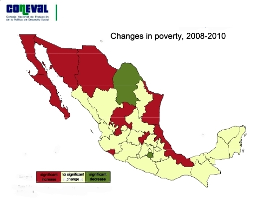
The map shows the Coneval data for changes in the poverty rate between 2010 and 2012 by state. It appears that poverty levels increased in many of Mexico’s more prosperous areas and in the longer established industrial areas, as well as in almost all areas where tourism is important. Poverty decreased in some of Mexico’s more rural, and generally poorer, states.

Related posts:

Dec 122013
 

Today is 12 December, the feast day of Our Lady of Guadalupe, the beloved indigenous patron saint of Mexico and much of the Americas. This seems like a good excuse, if ever one was needed, to revisit the “Gender Gap” in Mexico. The gender gap assesses the “gap” between females and males for a number of variables, but should not be taken as reflecting the quality of life of females in different countries.  For example, the gender gap between women in Japan and Japanese men is very large, even though Japanese women enjoy a relatively high quality of life.

In “The Global Gender Gap Report 2013″, the World Economic Forum (WEF), based in Geneva, Switzerland, placed Mexico 68th of the 136 nations included in the study. Between them, the 136 nations house 93% of the world population. Mexico has risen 16 places in the rankings since 2012, meaning that the gender gap in Mexico is narrowing, even if there is still a long way to go to reach gender equality. (It is worth noting that Mexico has been climbing steadily up the rankings for several years, from #98 in 2009, to #91 in 201, #89 in 2011 and #84 in 2012).

Of the 136 countries studied for the 2013 report, Iceland had the smallest gender gap, for the 5th year running, followed by Finland, Norway and Sweden.

Among Latin American nations, Nicaragua had the smallest gender gap (placing 10th in the world), with Cuba, which has the highest female participation in government, coming in 15th and Brazil remaining 62nd. Other notable placings were Germany 14th, and South Africa 17th.

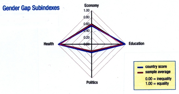
gender gap graph for Mexico

How Mexico (country score) compares to other countries (sample average). Source: Gender Gap Report 2013

The Gender Gap Index is a composite index comprised of a number of variables grouped into four key areas:

  • health and survival
  • educational attainment
  • political empowerment
  • economic participation

As noted in our summary of the 2012 Gender Gap Report, Mexico ranks #1 in the world, tying with several other countries, for the health and survival subindex. This means that Mexican females are unsurpassed with respect to sex ratio at birth (female/male) combined with female life expectancy (female/male).

For the other subindexes, in 2013 Mexico ranked #36 for political empowerment and #70 for educational attainment, but a lowly #111 for economic participation.

Geo-Mexico agrees wholeheartedly with Klaus Schwab, founder and executive chairman of the World Economic Forum, who called for renewed efforts to ensure gender equality, saying that, “Countries will need to start thinking of human capital very differently – including how they integrate women into leadership roles. This shift in mindset and practice is not a goal for the future, it is an imperative today.”

Related posts:

Example of a sixteenth century map

 Other  Comments Off on Example of a sixteenth century map
Dec 072013
 

In the mid-sixteenth century, the Spanish Court was determined to acquire accurate information about everything being encountered in New Spain. This led to a series of censuses and accounts, including the Relaciones geográficas (Geographic Accounts).

The basis for the Geographic Accounts was a 50-question survey, sent to New Spain in 1577. The authorities in each administrative center were instructed to call a meeting of the “Spaniards and other natives in the district”, to find out everything they could about the area’s geography, people and history.

Of the 191 known responses to the 1577 questionnaire, 167 have survived in archives to the present day. Most of the original responses are housed in Spain, in either the Archivo General de las Indias in Seville or the Real Academia de la Historia in Madrid, while a further 43 responses form part of the Benson Latin American Collection in the University of Texas library in Austin. (The library’s webpage about the Relaciones geográficas has several links to images of sample pages and maps).

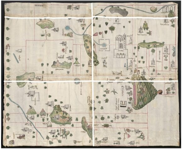
Map of Zempoala area from the Relaciones Geográficas

Map of Zempoala area from the Relaciones Geográficas (1577)

The accounts contain a wealth of information about population, relief, flora, fauna, economic activities and lifestyles. Some also include maps of the areas being described. However these early maps do not follow modern conventions in terms of having a uniform scale across the area being shown, or an orientation that is consistent in terms of compass directions. They are pictorial maps, where the scale varies across the map, and where areas are delimited, or places are linked, without apparent regard for direction.

One such map (see image above) depicts the area around Zempoala (Hidalgo). This is analyzed by Barbara E. Mundy, Associate Professor of Art History at Fordham University, in an online article, Mapping Babel: A Sixteenth-Century Indigenous Map from Mexico, published in The Appendix, a “journal of narrative and experimental history”. In the article, Mundy provides a detailed, step-by-step account of the map, with lots of additional related images and information.

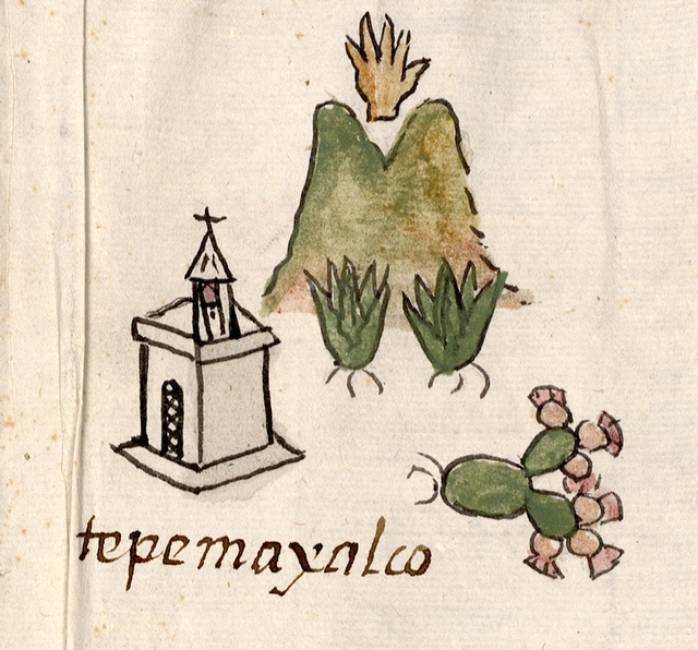
Detail of map, showing Tepemayalco

Detail of map, showing Tepemaxalco

Mundy’s analysis reveals several “acts of translation” that have been made by the indigenous artist(s) presumed to be responsible for drawing the map.

For example, the artist(s) made the Spanish paper provided for the map more closely resemble its indigenous counterpart (bark paper), by joining sheets together to create the size they wanted for the map. In addition, unlike modern maps where the viewer is essentially static, with the map details arranged around them, indigenous maps demand changes of perspective, mobile viewers, who have to reorientate themselves depending where they are on the map in order to see things clearly.

Many of the images are a translation, perhaps of similar European images. For instance, like most towns on the map, Tepemaxalco is shown with “a conventional sign for a Christian chapel: a small building drawn in perspective with one side marked by a shadowing grey wash, topped with belfry and cross.”

The map also links the pictograph for each place name to its name written in alphabetic script. “The pictograph for Tepemaxalco (see image) registers some of its Nahuatl components: tepetl, ‘hill,’ maitl, ‘hand,’ xalli, ‘sand’ and co, ‘place of.’ Below, the name is written in alphabetic script, probably introduced by the Franciscans who evangelized this region.”

The dominant pictogram on this map is that for Zempoala (written “Cenpoballa” on the map). Mundy offers an interesting interpretation of this pictograph, which we hope to examine further in a future post.

Further reading

Barbara E Mundy. 2001. The Mapping of New Spain: Indigenous Cartography and the Maps of the Relaciones Geográficas.

Related posts:

Disparities in wealth in Mexico: trends include a growing middle class as well as more millionaires

 Mexico's geography in the Press  Comments Off on Disparities in wealth in Mexico: trends include a growing middle class as well as more millionaires
Jun 242013
 

Two recent studies shed an interesting light on the distribution of wealth in Mexico. The first, carried out by the the National Statistics Agency (INEGI) is that agency’s first ever analysis of Mexico’s social classes. The study found that 12.3 million homes and 44 million people (39% of the total population) were “middle class” in 2010, up from 35% in 2000. In urban areas, 47% of the population was middle class, compared to just 26% in rural areas. Middle class homes had at least one computer, spent about 115 dollars [1,470 pesos] a month on eating and drinking outside the home, had at least one resident with a credit card and one with formal employment. In most cases, the head of household had gained a tertiary qualification. The same report found that almost 60% of Mexico’s population matched the criteria for “lower class”, while only 1.7% of the population could be best described as “upper class”.

However, a second study, by consultancy WealthInsight (“Mexico Wealth Book: Trends in Millionaire Wealth“) provides compelling evidence that the number of wealthy and super-wealthy individuals in Mexico has risen sharply. From 2007 to 2012, during the administration of President Felipe Calderón, the number of millionaires in Mexico rose by 32%, whereas the global average for the same period (which included economic recession in the USA and Europe) declined by 0.3%.

WealthInsight found that in 2012 Mexico had 145,000 individuals with a “High Net Worth” (defined as over a million dollars in assets besides their principal residence). Together these high net worth individuals hold a fortune of $736 billion, equivalent to 43% of Mexico ‘s total individual wealth. This number is well above the worldwide average of 29%, indicating that Mexico has a relatively uneven distribution of wealth. What’s more, WealthInsight expects the trend to continue and predicts that by 2017, the number of millionaires in Mexico will grow a further 47% to reach 213,000.

Included in the figure for millionaires are 2,540 multimillionaires (with individual net assets of $30 million or more), 2272 “affluent millionaires”(net assets between $30
million and $100 million) and 252 “centimillionaires” (net assets between $100 million and $1 billion). Mexico also has 16 billionaires, a number expected to rise to 21 by 2017. Grouped together, these ultra high net worth individuals are worth $364 billion in total combined wealth. By 2017 the total wealth of multimillionaires is projected to increase by 44% to reach $525 billion. The report predicts that the total wealth of Mexican billionaires will grow by 26% to reach $241 billion by the end of 2017.

The Mexican city with most multimillionaires is Mexico City; 43% of them make their home there.

Related articles:

Apr 212013
 

One of the most curious of Mexico’s dozens of indigenous languages is the whistled language of one group of the Chinantec people who live in the state of Oaxaca. This group’s conventional spoken language is complemented by a language based entirely on whistles. Only a few people remain who speak this whistled language fluently. The language is whistled primarily by men (and much less fluently by children); female members of the group understand it but do not use it.

It is thought that whistled languages developed to enable communication between isolated settlements in areas that were too remote for conventional spoken languages to be effective. The Chinantec’s whistled language has three distinct subsets, designed to be used over different distances. The loudest enables effective communication over a distance of around 200 meters (650 ft).

The Whistled Language of Oaxaca, Mexico

The Chinantec whistled language is now largely confined to the mist- and fog-shrouded slopes of the eastern side of the Sierra Juárez in the northern part of Oaxaca state, a region of high rainfall totals and luxuriant vegetation.

This 27 minute documentary relates the field studies investigating the Chinantec whistling language conducted by Dr. Mark Sicoli, Assistant Professor of Linguistics at Georgetown University. The main center of population of speakers of the whistling language is San Pedro Sochiapam. Sicoli believes that the whistled language may become extinct in the next decade; he hopes that his work documenting the language may one day provide the basis for its reintroduction or restoration.

A transcription of a whistled conversation in Sochiapam Chinantec between two men in different fields was available on the Summer Institute of Linguistics website, which also includes this useful summary of the Chinantec people and language. [at http://www-01.sil.org/mexico/chinanteca/sochiapam/13i-Conversacion-cso.htm in April 2013]

If you only have a few minutes to devote to this video, then look at the section around 16 minutes in, where in a controlled experiment, one experienced Chinantec whistler helps a friend “navigate” through a fictitious village. The men each have a copy of a made-up map of the village, but are out of sight and able to communicate only by whistling.

The astonishing whistled language of the Chinantec is yet another of Mexico’s many cultural wonders that currently appears to be headed for extinction.

Further reading:

Related posts:

The world’s richest man is one of 15 Mexican billionaires on 2013 Forbes list

 Updates to Geo-Mexico  Comments Off on The world’s richest man is one of 15 Mexican billionaires on 2013 Forbes list
Mar 072013
 

The 2013 Forbes list of the world’s billionaires shows that the world’s 1,426 billionaires (an all-time high) share a record net worth of $5.4 trillion. The four countries with most billionaires are the USA (442), China (122), Russia (110) and Germany (58).

Fifteen Mexican individuals or families make the 2013 list, also a record number. The fifteen super-rich Mexicans are:

World rank / Name / Estimated wealth according to Forbes / Main business interests

#1 Carlos Slim Helú and family, $73.0 billion, making him the richest man in the world. Fixed line telephone provider Telmex, cell phone provider América Móvil, Grupo Carso, Inbursa. [Slim Helú remains the world’s richest man for the fourth consecutive year]

#32 Alberto Bailleres González and family, $18.2 billion. Mining giant Peñoles, department store El Palacio de Hierro and Grupo Profuturo.

#40 Germán Larrea Mota Velasco and family, $16.7 billion. Grupo México –mining for copper and other minerals, railways.

#111 Ricardo Salinas Pliego and family, $9.9 billion. Television company Televisón Azteca, domestic appliance store Elektra, bank Banco Azteca, and cell phone company Iusacell.

#179 Eva Gonda Rivera and family, $6.6 billion, soft drinks (FEMSA)

#248 Maria Asunción Aramburuzabala and family, $5 billion, beer (Grupo Modelo)

#329 Jerónimo Arango and family, 4 billion dollars. Founder of Aurrerá supermarket chain and Grupo Cifra which controlled VIPS and El Portón restaurant chains, Suburbia department stores and tourist developments in Baja California Peninsula and Acapulco

#589 Emilio Azcárraga, $2.5 billion. Television and media conglomerate Televisa, and Nextel cell phones

#613 Rufino Vigil González, $2.4 billion; steel (Industrias CH)

#641 José and Francisco Calderón Rojas (brothers), $2.3 billion, beverages (Coca-Cola Femsa)

#792 Carlos Hank Rhon and family, $1.9 billion, banking

#831 Roberto Hernández, $1.8 billion. Banker, one of main shareholders of Citigroup, and tourist developments in the Yucatán Peninsula

#974 Alfredo Harp Helú and family, $1.5 billion. Shareholder in Citibank, telecommunications firm Avantel

#1031 Max Michel Suberville, $1.4 billion, retail (Coca-Cola Femsa)

#1107 Juan Gallardo Thurlow, $1.3 billion, beverages (organización Cultiba)

Conspicuous by his absence from the list (for the first time in several years) is Joaquín Guzmán Loera (aka “El Chapo”) who Forbes has consistently claimed has a net worth of about $1 billion, but whose assets the magazine now declares “impossible to verify”. Guzmán Loera is Mexico’s most wanted man, head of the Sinaloa drugs cartel, the main supplier of cocaine to the US market.

The combined total wealth of these fifteen individuals is a staggering $148.5 billion (compared to an equivalent total of $125.1 billion in 2012). The 2013 figure is equivalent to more than 6% of Mexico’s GDP.

The average earnings of Mexican workers registered in IMSS (Mexico’s Social Security Institute) in 2012 was about 260 pesos ($20 dollars) a day. The combined wealth of Mexico’s fifteen richest individuals/families is therefore equivalent to the total annual salaries of more than 20 million Mexicans earning this average salary! Note that this equivalence has risen steadily over recent years. For example, in 2010 the combined wealth of Mexican billionaires was equivalent to “only” 14.3 million Mexicans earning the then average salary.

Clearly, there are a handful of extremely wealthy individuals living in Mexico, alongside millions of Mexicans who are living at or below the poverty line. These income disparities have existed for a very long time, and are examined in detail in chapter 14 of Geo-Mexico: the geography and dynamics of modern Mexico. That chapter also analyzes the spatial patterns of wealth in Mexico, and discusses whether the gap between rich and poor has widened or narrowed in recent years.

Chapter 29 discusses Gender inequities in Mexico and  Oportunidades, a poverty reduction program (links are to excerpts from that chapter).

Related articles:

The important role of telenovelas and historietas as forms of communication in Mexico

 Excerpts from Geo-Mexico  Comments Off on The important role of telenovelas and historietas as forms of communication in Mexico
Dec 312012
 

The highest rating programs on TV are televised novels, telenovelas. A telenovela is a limited‑run television serial melodrama, somewhat like a soap opera but normally lasting less than a year, and where the eventual ending has already been scripted.

image of los ricos tambien lloranThe first global telenovela was Los ricos también lloran (“The rich cry too”), originally shown in 1979. Telenovelas are now a $200 million market. Some critics claim they are effective promoters of social change, others deride them as being nothing more than mass escapism. Whichever view is more accurate, their portrayals reflect society’s values and institutions.

Advocates of telenovelas point to their role in challenging some traditional Mexican media taboos by including story lines about urban violence, racism, homosexuality, birth control, physical handicaps, political corruption, immigration and drug smuggling. Early telenovelas tended to be shallow romantic tales. The form subsequently evolved to include social commentaries and historical romances, some applauded for their attention to historical detail. Some were used for attempts at social engineering. An early government-sponsored telenovela promoted adult literacy programs. Several others openly advocated family planning and have been credited with contributing to Mexico’s dramatic decline in fertility rate. Other telenovelas have targeted younger audiences, focusing on issues connected to pop music, sex and drugs.

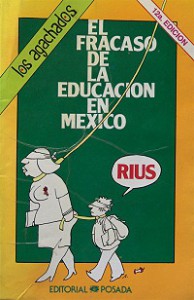
Rius historieta: The failure of education in Mexico

Rius historieta: The failure of education in Mexico

Besides the shallowness of the plot lines in most telenovelas, the other common criticism is that their stars are almost always white-skinned, blue-eyed blondes. Sadly, all too often, actors with indigenous looks are relegated to roles portraying menial workers such as home help or janitors.

Telenovelas have been extraordinarily successful commercially. They have become immensely popular not only in Latin America and among the US Hispanic population but also in more than 100 other countries, mainly in Eastern Europe and Asia.

In print media, a similar role to the telenovela has been played by historietas (comic books), the best of which have tackled all manner of social, political and environmental issues well before such topics made the main-stream press. Historietas helped educate millions of Mexicans and were also a commercial success. Their circulation peaked in the 1980s but has since declined due to competition from television and, more recently, the internet. The most influential creator of historietas is the cartoonist and writer Eduardo del Río (Rius) whose work earned him a 1991 United Nations Environment Programme prize.

Related posts:

Decision about GM corn in Mexico postponed until 2013

 Mexico's geography in the Press  Comments Off on Decision about GM corn in Mexico postponed until 2013
Dec 012012
 

Mexico’s new president Enrique Peña Nieto took office earlier today. His single, six-year term will end in 2018. The change of government means that a final decision about the commercial planting of genetically modified (GM) corn in Mexico has been postponed until sometime early next year.

As we have seen in several previous posts, GM corn is a hotly disputed topic in Mexico.

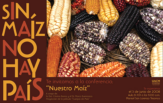
Corn poster

“Without corn there is no nation” (Conference poster, Autonomous University of Chihuahua)

Proponents argue that GM corn will lead to higher yields and reduce losses from pests and diseases. In their view, the commercial planting of GM corn in Mexico is inevitable and will help Mexico “catch up” with Brazil and Argentina, where GM crops are already being grown.  Opponents argue that GM corn will inevitably reduce the genetic diversity of corn, meaning that corn will have less resilience in future to unexpected (and unpredicted) changes (climate, pests, soil conditions, etc). They also argue that GM corn will make corn growers even more dependent on commercial seed producers.

US farmers have found that GM corn lives up to its advertised higher yields and disease resistance. Farmers organizations in northern Mexico have come out in public support of this view, though many farmers in the center and south of the country remain vehemently opposed to GM corn on the basis that cross-contamination would deplete the plants’ gene pool, and possibly lead to the eventual extinction of traditional corn varieties.

Mexico was the world’s 6th largest grain producer in 2010, but fell to 8th spot in 2011. In just 20 years, Mexico has gone from a nation that needed to import less than 400,000 metric tons of corn a year in order to satisfy its domestic market to one where, in the 2012-12 season, it will need to import about 11,000,000 tons. Mexico’s corn imports, mainly of yellow corn for animal feed, are expected to rise to 15,000,000 tons by 2020. Corn prices are also likely to rise since an increasing portion of the annual US corn crop is  destined for biofuel production rather than human consumption.

Mexico currently produces about 22 million metric tons of corn (mainly white corn for human consumption) from 7.2 million hectares nationwide. According to press reports, there are five applications for planting GM corn on a commercial scale. The total area involved is 2.5 million hectares (6.2 million acres).

  • The transnational seed firm Monsanto has two proposals, each for 700,000 hectares, in Sinaloa, Mexico’s leading corn-producing state
  • Pioneer Hi-Bred International (currently owned by DuPont) has submitted three applications, each for around 350,000 hectares, in Tamaulipas
  • Dow Agrosciences (a unit of Dow Chemical) has applied to grow GM corn on 40,000 hectares, also in Tamaulipas.

It is widely believed that the new government will approve the large-scale trials of GM corn that the companies are requesting. It is likely, however, that GM corn will be confined to certain areas of Mexico only, with other areas designated “centers of origin” for corn where cultivation of GM seeds would not be permitted.

Among the most vocal opponents to the plans for GM corn is the ETC (Action Group on Erosion, Technology and Concentration) group. They set out their views in a multi-page news release. Verónica Villa, of ETC’s Mexico Office, says that,

“If Mexico’s government allows this crime of historic significance to happen, GMOs will soon be in the food of the entire Mexican population, and genetic contamination of Mexican peasant varieties will be inevitable. We are talking about damaging more than 7,000 years of indigenous and peasant work that created maize – one of the world’s three most widely eaten crops.”

Geo-Mexico will continue to report on this issue as it develops in coming months.

Want to learn more? This short open letter from the Unión de Científicos Comprometidos con la Sociedad (Union of Socially-Committed Scientists)  ~ Call to action vs the planting of GMO corn in open field situations in Mexico ~ has an extensive bibliography.

Related posts:

Juchitán, Oaxaca: a town of sexual tolerance

 Excerpts from Geo-Mexico, Mexico's geography in the Press  Comments Off on Juchitán, Oaxaca: a town of sexual tolerance
Oct 182012
 

More than half (51.3%) of Mexico’s total population of is female. (There are 94.8 men for every 100 women.) However, with isolated exceptions, Mexico has been a male-dominated society for a long time and the spirit of machismo is still very strong in many parts of the country. There is ample evidence for this. For example, Mexico has never had a female head of state and very few female cabinet members have ever been appointed. There have been very few female candidates for president; they include Cecilia Soto González (1994), Dora Patricia Mercado (2006) and Josefina Vázquez Mora (2012). [Thanks go to Manuel and other alert readers for correcting an earlier version]. In business, male executives earn more than their female counterparts, though the wage differential is much smaller for lower-paid positions.

There are also vast differences across the country in the economic and social well-being of women. Some women, such as billionaire María Asunción Aramburuzabala, have proved that Mexican women can be incredibly successful in business, yet tens of thousands of women face a daily struggle against starvation and violence in the home.

The precise roles of women in Mexican society vary greatly from one region to another. The indigenous Zapotec community of Juchitán in the Isthmus of Tehuantepec region of Oaxaca is at one extreme. It functions as a matriarchal society where women play a much more important role than men in trading and decision-making.

Juchitán is also possibly the most tolerant place in Mexico in terms of attitudes to the gay and transgender community, especially to transvestite men, locally called muxes (pronounced moo-shays).

A 5-minute video, The Third Gender, produced by Deborah Bonello for GlobalPost, explores the extent to which the residents of Juchitán accept cross-dressing muxes as an integral part of society.

Want to read more?

  • Nicola Ókin Frioli. Princesses in a land of Machos (short essay and outstanding photographs by a highly accomplished photographer)
  • Bennholdt-Thomsen, V. 2005 A matriarchal society in the age of globalization: Juchitán/Southern Mexico.  Paper presented at 2nd World Congress on Matriarchal Studies, San Marcos and Austin, Texas. 2005
  • Isabella Tree. The women of Juchitán (Inside Mexico)
  • Marc Lacey. A Lifestyle Distinct: The Muxe of Mexico (New York Times)

Related posts:

Oct 012012
 

Mexico currently has 65 Magic Towns (Pueblos Mágicos), some of which we have described in previous posts. Regular readers will know we have some reservations about the program, especially about the inclusion on the list of some places that have relatively little to attract the average tourist.

Are Magic Towns distributed evenly across the country?

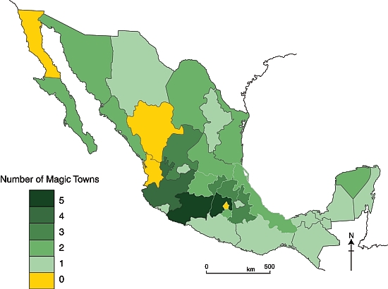
The map shows the distribution of the 57 Magic Towns, by state, as of 1 October 2012. Magic Towns are clearly not evenly distributed across Mexico. Two states – the State of México and Michoacán– each have five Magic Towns, while Jalisco has four. It is no surprise that the Federal District (México D.F.) is not designated a Magic Town, but it is a surprise that there are no Magic Towns in Baja California, Durango or Nayarit. Mexcaltitán, an island town in Nayarit, was one of the first towns in Mexico to be designated a Magic Town, but had this status revoked in 2009.

Mexico's Magic Towns, by state (September 2012)

Mexico’s Magic Towns, by state (September 2012)

Southern Mexican states appear to be drastically underrepresented, especially when area of state, population and indigenous groups are taken into account.

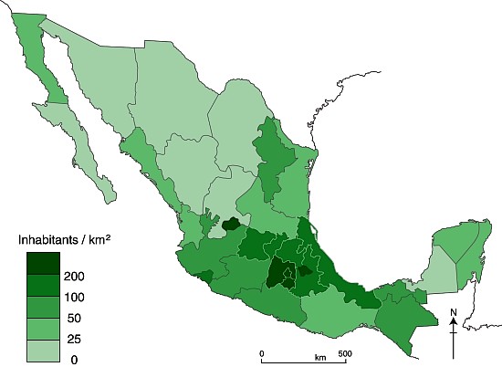
Population density map

Mexico’s population density in 2010

Larger states (in area and/or population) would surely  be more likely to have more Magic Town candidates. However, it is clear from comparing the maps of Magic Towns and population density (above) that the number of Magic Towns does not appear to be related to either the area of states, or to their population density.

The major indigenous groups in Mexico

The major indigenous groups in Mexico

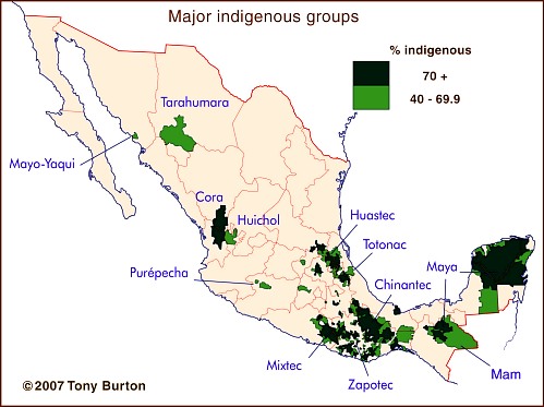
Indigenous groups are relevant because they tend to live in relatively remote areas of great natural beauty, such as the Copper Canyon region or the Huasteca, and they also exhibit many distinctive cultural traits, giving them a head-start in the race to demonstrate their attractiveness for tourism. Again, though, there is little common ground between the map of indigenous groups and the map of Magic Towns. In particular, the states of Guerrero, Oaxaca and Campeche all seem to have fewer Magic Towns than might be expected.

Voting patterns in presidential elections, 2006 and 2012

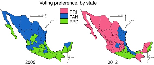
Voting patterns in presidential elections, 2006 and 2012. All rights reserved.

Even politics does not appear to help explain the distribution of Magic Towns, though it must be pointed out that the pattern of voting for presidential elections (maps) may not match the pattern of municipal voting which would be more relevant to applications for Magic Town status.

If and when more towns are added to the Magic Towns list, perhaps the reasons for their distribution will become more obvious.

This post examined the distribution of Mexico’s Magic Towns, as of 1 October 2012, at which point there were only 57 in total. Since this post was written, additional Magic Towns include:

There is no doubt that Mexico has many other places that would be very worthy additions to the list. Which places would you add?

Related posts:

Aug 302012
 

Veteran blogger Matt Osborne has unearthed a real gem! This 1977 BBC documentary was the tenth episode of The Age of Uncertainty, John Kenneth Galbraith’s history of economic thought. In this episode, Galbraith examines the economics of poverty and inequality.

The section of greatest interest to Geo-Mexico readers is his overview of the changing relationships between land and people in Mexico from precolonial times to the 1970s. [This ten minute segment starts at minute 4:33 of the video].

Galbraith does confuse his Teotihuacanos with his Aztecs, and clearly many things have changed since 1977, but this video is a great and straightforward introduction to the complex issues of land resources and population, suitable as the starting point for many discussions at high school or college level about land clearance, the financing of land improvement, the Green Revolution, population growth and social organization.

Related posts:

The world’s richest man in 2011 and other Mexican billionaires

 Mexico's geography in the Press, Updates to Geo-Mexico  Comments Off on The world’s richest man in 2011 and other Mexican billionaires
Mar 192012
 

The Forbes magazine list of the world’s richest individuals in 2011 consists of more than 1500 individuals, each with a wealth of one billion dollars or more. Eleven Mexicans (all men, but one more than last year) made the list. The eleven richest Mexicans are:

World rank / Name / Estimated wealth according to Forbes / Main business interests

#1 Carlos Slim Helú and family, 69.0 billion dollars, making him the richest man in the world. Fixed line telephone provider Telmex, cell phone provider América Móvil, Grupo Carso, Inbursa. [Slim Helú stays in top spot]

#37 Ricardo Salinas Pliego and family, 17.4 billion dollars. Television company Televisón Azteca, domestic appliance store Elektra, bank Banco Azteca, and cell phone company Iusacell [Salinas Pliego gained 26 places in the ranking]

#38 Alberto Bailleres and family, 16.5 billion dollars. Mining giant Peñoles, department store El Palacio de Hierro and Grupo Profuturo [almost doubled his wealth in 2011, up 44 places]

#72 Germán Larrea Mota Velasco and family, 14.2 billion dollars. Grupo México – mining for copper and other minerals

#276 Jerónimo Arango and family, 4 billion dollars. Founder of Aurrerá supermarket chain and Grupo Cifra which controlled VIPS and El Portón restaurant chains, Suburbia department stores and tourist developments in Baja California Peninsula and Acapulco

#634 Emilio Azcárraga, 2.0 billion dollars. Television and media conglomerate Televisa,and Nextel cell phones

#683 Roberto Gonzalez Barrera 1.9 billion dollars. Banking and tortillas

#913 Carlos Hank Rhon & family, 1.4 billion dollars. Banking

#960 Roberto Hernández, 1.3 billion dollars. Banker, one of main shareholders of Citigroup, and tourist developments in the Yucatán Peninsula

#1153 (equal) Alfredo Harp Helú and family, 1 billion dollars. Shareholder in Citibank, telecommunications firm Avantel

#1153 (equal) Joaquín Guzmán Loera (aka “El Chapo”), 1 billion dollars. Mexico’s most wanted man, head of the Sinaloa drugs cartel, the main supplier of cocaine to the US market

The combined total wealth of these eleven individuals is a staggering 129.7 billion dollars (compared to the billionaires’ total of 90.3 billion dollars in 2010). The 2011 figure is equivalent to more than 6% of Mexico’s GDP.

The average earnings of Mexican workers registered in IMSS (Mexico’s Social Security Institute) is about 230 pesos a day or $6,600 (dollars) a year. The combined wealth of Mexico’s eleven richest individuals is therefore equivalent to the total annual salaries of 19.65 million Mexicans earning this average salary! [Last year, the combined wealth of Mexican billionaires was equivalent to “only” 14.3 million Mexicans earning the then average salary.]

Clearly, there are a handful of extremely wealthy individuals living in Mexico, alongside millions of Mexicans who are living at or below the poverty line. These income disparities have existed for a very long time, and are examined in detail in chapter 14 of Geo-Mexico: the geography and dynamics of modern Mexico. That chapter also analyzes the spatial patterns of wealth in Mexico, and discusses whether the gap between rich and poor has widened or narrowed in recent years.

Chapter 29 discusses Gender inequities in Mexico and  Oportunidades, a poverty reduction program (both links are to excerpts from that chapter).

Related articles:


Mexico has more World Heritage sites than any other country in the Americas

 Other  Comments Off on Mexico has more World Heritage sites than any other country in the Americas
Mar 172012
 

The status of World Heritage site is a UNESCO (United Nations Educational, Scientific and Cultural Organization) denomination. The status is conferred on selected sites under the terms of “The Convention Concerning the Protection of the World Cultural and Natural Heritage”, adopted at UNESCO’s 17th General Conference in November 1972 and subsequently ratified by 189 member states.

Nations were invited to submit their proposals for any cultural or natural sites that they considered “of outstanding universal value”, and therefore eligible for inclusion on the World Heritage list. All proposals have to be approved by a special UNESCO World Heritage Committee.

The attraction of having a site classified as a World Heritage site is that it affords extra possibilities for obtaining technical co-operation in matters relating to conservation, for international assistance for research, training and equipment, and for emergency assistance in the event of damage due to specific natural or man-made disasters. All these sites are also valuable as cultural or environmental tourism destinations.

The list was first published in 1978, at which time it mainly featured European sites. Since then, regular additions have been made. As of March 2012, the list includes 936 locations in 153 member states. Of these sites, 725 are considered to have cultural significance, 183 to have natural importance and there are also 28 which share both cultural and natural value.

Mexico has 31 sites on the list, considerably more than any other country in the Americas. For example, the U.S. has 20 (together with a share of a 21st that straddles the border with Canada), Brazil 17 (as well as one jointly held with Argentina), Canada 14 (plus the joint U.S.-Canada site) and Peru 11.

Worldwide, only five countries have more World Heritage sites than Mexico. Four of these countries are in Europe: Italy, Spain, Germany and France. The other country is China.

Mexico’s existing World Heritage sites

Date added to list  – Name of site (state in brackets)

1987 Sian Ka’an biosphere reserve (Quintana Roo)
1987 Pre-Hispanic city and national Park of Palenque (Chiapas)
1987 Historic Center of Mexico City and Xochimilco (Mexico D.F.)
1987 Pre-Hispanic city of Teotihuacan (State of Mexico)
1987 Historic Centre of Oaxaca and archaeological site of Monte Alban(Oaxaca)
1987 Historic Centre of Puebla (Puebla)
1988 Historic town of Guanajuato and Adjacent Mines (Guanajuato)
1988 Pre-Hispanic city of Chichen-Itza (Yucatán)
1991 Historic Centre of Morelia (Michoacán)
1992 Pre-Hispanic city of El Tajin (Veracruz)
1993 Whale Sanctuary of El Vizcaino (Baja California)
1993 Historic Centre of Zacatecas (Zacatecas)
1993 Rock Paintings of the Sierra de San Francisco (Baja California)
1994 Earliest 16th-Century monasteries on the slopes of Popocatepetl (Morelos)
1996 Prehispanic town of Uxmal (Yucatán)
1996 Historic Monuments, Zone of Querétaro (Querétaro)
1997 Hospicio Cabañas, Guadalajara (Jalisco)
1998 Historic Monuments, Zone of Tlacotalpan (Veracruz)
1998 Archeological Zone of Paquimé, Casas Grandes (Chihuahua)
1999 Historic fortified town of Campeche (Campeche)
1999 Archaeological Monuments, Zone of Xochicalco (Morelos)
2002 Ancient Maya City and biosphere reserve of Calakmul (Campeche)
2003 Franciscan Missions in the Sierra Gorda (Querétaro)
2004 House and Studio of Luis Barragán (in Mexico City)
2005 Islands and protected areas of the Gulf of California
2006 Agave landscape and old tequila-making facilities in Amatitán, Arenal and Tequila (Jalisco)
2007 Central University City Campus of the Universidad Nacional Autónoma de México (UNAM) (Mexico City)
2008 Monarch Butterfly Biosphere Reserve (Michoacán and State of México)
2008 San Miguel de Allende and the Sanctuary of Jesús de Nazareno de Atotonilco (Guanajuato)
2010 Camino Real de Tierra Adentro, the 2,900 kilometer historic route linking Mexico City to Santa Fe in New Mexico
2010 Prehistoric caves of Yagul and Mitla in the Central Valley of Oaxaca

Mexico’s proposed World Heritage sites:

Mexico has formally proposed numerous additional sites for World Heritage Status. The applications are coordinated by the National Anthropology and History Institute (Instituto Nacional de Antropología e Historia), better known by its Spanish acronym INAH. Proposals include:

1.  Historic town of San Sebastián del Oeste (Jalisco)
2. Tule (ahuehuete) tree of Santa María del Tule (Oaxaca)
3. Zempoala aqueduct, a project of Padre Tembleque (Hidalgo and State of Mexico)
4. Monterrey’s old industrial facilities, including a foundry, brewery and glassworks (Nuevo León)
5. The Aguascalientes railroad station and residential complex (Aguascalientes)
6. The Museo Casa Estudio Diego Rivera and Frida Kahlo (Mexico D.F.)
7. Ludwig Mies van Der Rohe and Félix Candela’s industrial buildings, including the offices of Bacardí y Compañía (State of Mexico)
8. Historic city of San Luis Potosí (San Luis Potosí)
9. Chapultepec Woods, Hill and Castle (Mexico D.F.)
10. Historic town of Alamos (Sonora)
11. Pre-Hispanic city of Cantona (Puebla)
12. The church of Santa Prisca in Taxco (Guerrero)
13. The former Jesuit college in Tepotzotlán (State of Mexico)
14. The churches of the Zoque province (Chiapas)
15. The pre-Hispanic city of Chicomostoc-La Quemada (Zacatecas)
16. Archaeological monuments, zone of Mitla (Oaxaca)
17. Cuatrociénegas flora and fauna reserve (Coahuila)
18. Franciscan convent and Our Lady of the Assumption cathedral in Tlaxcala (Tlaxcala)
19. Historical town of the Royal Mines of Cosala (formerly known as the Royal of the Eleven Thousand Virgins of Cosala) (Sinaloa)
20. Huichol Route used by Huichol Indians through their sacred sites to Huiricuta (San Luis Potosí) (sometimes spelt as Wirikuta)
21. The former textile factory La Constancia Mexicana and its housing area (Puebla)
22. The Lacan-Tún—Usumacinta region (Chiapas)
23. The Banco Chinchorro Biosphere Reserve(offshore in Quintana Roo)
24. The El Pinacate and the Great Altar Desert Biosphere Reserve (Sonora)
25. The Selva El Ocote Biosphere Reserve (Chiapas)
26. Sotáno del Barro, a 450-meter-deep sinkhole (Querétaro)
27. Tecoaque archaeological site (Tlaxcala)
38. Valle des Cierges, including Montevideo Canyon (Baja California)

Not all sites are accepted. For instance, Mexico’s rejections include the Lake Pátzcuaro region, in the state of Michoacán, and the El Triunfo nature reserve.

Mexicans are justly proud of their nation’s history and culture, and have always been prepared to share them with visitors. By getting so many locations on UNESCO’s list of World Heritage sites, the country is reaffirming its commitment to trying to ensure that its cultural and natural treasures are well protected for future generations. Any of the places mentioned in this article is well worth visiting and exploring. In some cases, it is possible to construct fascinating “itineraries” combining several of the sites in a single trip.

Bear in mind, though, that there are also numerous attractions not yet listed as World Heritage sites that probably deserve to be included in the future. For starters, how about Paricutin Volcano, one of only a handful of new volcanoes to appear on land in historic times? Or how about the Copper Canyon region, with its grandiose scenery and indigenous Tarahumar population?

For more information:

Related articles:


Map of Oaxaca state, with an introduction to its geography

 Maps  Comments Off on Map of Oaxaca state, with an introduction to its geography
Mar 122012
 

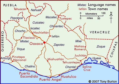
The state of Oaxaca is Mexico’s fifth largest state, with an area of  93,793 square kilometers (4.8% of the national total) and Mexico’s tenth most populous state, with 3.8 million inhabitants in 2010.

The state has considerable variety in terms of relief, climate and natural vegetation, and has about 570 km of shoreline bordering the Pacific Ocean. Oaxaca City, the centrally located state capital, is an important city for tourism as are three towns on the coast—Puerto Angel, Puerto Escondido and Huatulco.

The eastern part of Oaxaca state is part of the low-lying Isthmus of Tehuantepec, once considered as an alternative location to Panama for a trans-continental canal. In recent years, the Tehuantepec area has received massive investments in wind power, with several major wind farms already operational and more on the drawing board.

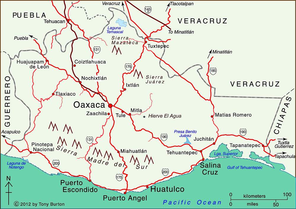
Map of Oaxaca state, Mexico. Copyright Tony Burton;

Map of Oaxaca state, Mexico. Copyright Tony Burton; all rights reserved. Click map to enlarge

Oaxaca state state has greater linguistic and cultural diversity than any other state in Mexico. According to the National Commission for the Development of Indigenous Peoples, more than 1.5 million people in Oaxaca live in a home where at least one of the residents either speaks an indigenous language or considers themselves indigenous (even if they do not speak an indigenous language).

About one million inhabitants of Oaxaca, 35% of the state’s total population, speak one or more indigenous language. The largest indigenous linguistic groups in the state include about 350,000 Zapotec, 230,000 Mixtec, 165,000 Mazatec, 100,000 Chinantec, 100,000 Mixe, and 40,000 Chatino.

Related posts:

The rapid expansion of electricity provision in Mexico

 Other  Comments Off on The rapid expansion of electricity provision in Mexico
Dec 092011
 

In the past two decades, Mexico has made very impressive progress in providing electricity to its citizens, especially those living in rural areas. The 87.5% of Mexicans that had electricity in 1990 lived mostly in cities and towns. Many of the 95.0% that had electricity in 2000 lived in rural areas. The proportion without electricity was cut way down to only 1.8% by 2010.

During the past decade, virtually all those who obtained electricity for the first time lived in rural areas. The gains in some states were very impressive. The proportion without electricity in Oaxaca went from 13% in 2000 to 5% in 2010. In San Luis Potosí and Chiapas it fell from 12% to only 4%. In Veracruz it dropped from 11% to just 3% and in Tabasco it went from 5.8% to only 1.2%.

Postage stamp commemorating the nationalization of Mexico's electricity industry

The states with the highest proportion without electricity in 2010 were Oaxaca (4.93%), Guerrero (4.38%) and Durango (4.19%). At the other end, were the Federal District (0.08%), Nuevo León (0.30%), Coahuila (0.54%) and Colima (0.59%).

Mexico may never be able to provide electricity to 100% of its citizens, since there are too many people living in very remote areas. In about 8% of municipalities (199 of 2456), more than 10% of the people lack electricity. Of these 199 municipalities, 81 are in Oaxaca, which has 570 municipalities, far more than any other state. Many of the other poorly serviced municipalities are in the relatively poor southern states of Guerrero (15), Veracruz (12), Chiapas (9), Puebla (7) and Michoacán (7).

A surprisingly number of these 199 municipalities are in two northern states: Chihuahua with 16 and Durango with 9. In fact, in 14 Chihuahua municipalities, over 25% of the population lack electricity and in 5 of these over 50% do not have electricity. In Durango the situation is only slightly better: in four municipalities over 25% lack electricity and in one of these 66% do not have electricity. These are among the worst-serviced communities in all of Mexico. In the whole country there are only 9 municipalities where over half the residents do not have electricity and 6 of these 9 are in Chihuahua or Durango. These very poorly-serviced areas are sparsely populated municipalities near the Copper Canyon, occupied mostly by the Tarahumara indigenous group.

Though there are sizable pockets of Mexicans that do have electricity, it is very impressive that, as of 2010, over 98% had access to power.

Source for data:

 CONAPO,Índice de marginación por entidad federativa y municipio. 2010” México D.F., October 2011.

 Related posts:

Is poverty in Mexico on the rise?

 Mexico's geography in the Press  Comments Off on Is poverty in Mexico on the rise?
Sep 062011
 

According to a recent government study, almost half of Mexico’s population now lives in poverty. The report came from the National Political and Social Development Commission (Spanish language acronym: Coneval). Poverty rates had been falling for several years, so this is clear evidence that Mexico’s economy has been struggling in the wake of the economic recession in North America.

How does Coneval define poverty?

Coneval uses a simple multidimensional poverty index, which considers the following criteria:

  • household income
  • access to education
  • access to food
  • access to health care
  • access to social services
  • housing quality
  • access to basic household services (electricity, water, drainage)

According to Coneval, people living on less than 2,114 pesos (about $180) a month in urban areas (or 1329 pesos in rural areas) and who lack at least one of the basic social rights in the list are living in poverty.

Extreme poverty (see map)  is applied to people living on less than 978 pesos ($85) a month in urban areas (684 pesos in rural areas) and lacking at least one social right.

Map of extreme poverty in Mexico 2010By these definitions, 46.2% of Mexico’s population (or about 52 million people) are currently living in poverty. This has risen from 44.5% in 2008. However, the percentage living in extreme poverty has dropped slightly since 2008 from 10.6% to 10.4%.

The distribution of poverty shown on the map above is not a surprise; we have seen many times in previous posts that the southern half of Mexico (excluding the Yucatán Peninsula) is much less wealthy in economic terms and social indicators than the north, even if it has a wealth of indigenous groups and cultural traditions.

The map below is perhaps more interesting since it highlights the areas where the incidence of poverty has changed significantly between 2008 and 2010. The green areas have experienced a significant decrease in poverty and the red areas a significant increase in poverty. It is clear that the effects of the economic recession are being felt much harder in northern Mexico, where export-led manufacturing is prominent, than in the south.

map of changes in poverty in Mexico, 2008-2010Poverty in Mexico is on the rise, and it is on the rise faster in northern Mexico than the already poverty-stricken south. Only time will tell whether this increase in poverty is a temporary and short-lived trend or whether it heralds the start of tough times for many people in Mexico, especially those living in the rural areas, where the incidence of poverty and extreme poverty are far higher than in urban areas.

Given that the income levels used to define poverty in urban areas are more generous than those used for rural areas, the true level of poverty in the Mexican countryside is almost certainly much higher than this study suggests, something for politicians to bear in mind as they gear up for national elections next year.

Related posts:

Mexico has forty UNESCO-designated biosphere reserves

 Other  Comments Off on Mexico has forty UNESCO-designated biosphere reserves
Jul 232011
 

A surprising percentage of Mexico’s land area is protected in one form or another. A very large number of sites of archaeological or historical importance are managed by the National Institute of Anthropology and History, more commonly known by its acronym INAH. In theory, all buildings more than 100 years old have some degree of protection (under INAH), but in practice this protection is often ignored by developers with other ideas.

Sites considered significant for their natural beauty are protected in a variety of ways, ranging from nature sanctuaries of local importance to protected areas, national parks and internationally recognized biosphere reserves. In total, more than 11.5% of Mexico’s land area is now protected. This percentage has risen steadily for more than a century.

The designation of biosphere reserve can only be made by UNESCO (U.N. Educational, Scientific and Cultural Organization), in a manner somewhat similar to the designation that some major historical sites enjoy as World Heritage Sites. One of the benefits of attaining Biosphere Reserve status is that it allows access to more sources of funding for conservation programs.

Mexico currently has 40 biosphere reserves. Only the USA (48), the Russian Federation (41) and Spain (41) have more. Worldwide, there are now (July 2011) 580 biosphere reserves in 114 countries. The guiding principle of biosphere reserves is that the local populace is not displaced, but actively involved in all aspects of management, research and monitoring.

Biosphere Reserve Zonation

Biosphere reserves have a research-intensive core area or areas at their heart, surrounded by a buffer zone, where sustainable development is fostered, before gradually transitioning into the surrounding region. Many reserves have innovative systems of governance designed to ensure that the views of local people are fully respected. The idea of biosphere reserves was first proposed in 1968 at the UNESCO “Biosphere Conference”, the first international attempt to reconcile the need for conservation with the use of natural resources for development.

No system is perfect. The challenges for biosphere reserves include strengthening the worldwide network by establishing new reserves in areas where few currently exist, as well as helping meet the on-going funding needs for all the reserves. One of the most significant future threats to biosphere reserves is likely to be the habitat changes wrought by global warming.

One of the more startling surprises in the existing network of reserves is the almost total lack of protection afforded to such an amazing part of Mexico as the Copper Canyon region, with its indigenous Tarahumara people and world-class scenery. But perhaps one day this region, too, will become part of Mexico’s extensive system of protected areas.

Mexico’s Biosphere Reserves, as of July 2011:

Baja California Peninsula:

  • El Vizcaíno (Baja California Sur): desert, mountain and coastal/marine ecosystems, petroglyphs, wall paintings, birds and Grey whales.
  • Sierra La Laguna (Baja California Sur): contrasting ecosystems, woodlands and scrub, with high degree of endemism.
  • Alto Golfo de California (Baja California and Sonora): extraordinary geological formations with volcanic craters, dunes, oasis and beaches, and a diversity of plant associations.
  • Islas del Golfo de California (Baja California Sur and Sonora): series of over 240 islands with high number of endemic species; ornithological paradise.

Northern Mexico:

  • Mapimí (Durango, Chihuahua and Coahuila): fragile warm desert and semi-desert ecosystems.
  • La Michilía (Durango): mountainous area of pine-oak forest; habitat for the now rare black bear (Ursus americanus) and wolf (Canis lupus).
  • El Cielo (Tamaulipas): one of the most ecologically rich and diverse parts of Mexico; numerous endangered animal species; ecotourism area.
  • Laguna Madre and Río Bravo Delta (Tamaulipas): a migratory bird haven on coastal wetlands.
  • Cumbres de Monterrey (Nuevo León): the landmark mountains that ensure the water supply for the state capital.
  • Maderas del Carmen (Coahuila): encompassing parts of the Chihuahuan Desert in Coahuila state adjacent to the U.S. biosphere reserve of Big Bend National Park.
  • Cuatrociénegas (Coahuila): an oasis with 500 pools that preserve species found only in the Coahuila state part of the Chihuahua desert.
  • Sierra de Alamos–Rio Cuchujaqui (Sonora): endangered tropical deciduous forest.

Central and Western Mexico:

  • Sierra de Manantlán (Jalisco and Colima): transition of the Nearctic and Neotropical biological realms; cloud forest and wild perennial corn (Zea diploperennis).
  • Chamela-Cuixmala (Jalisco): a Pacific Coast dry tropical forest harboring iguanas and crocodiles in lagoons and marshes.
  • Islas Marietas (Nayarit): a biodiverse archipelago of islands with a rich mix of marine species, corals and landforms.
  • La Primavera (Jalisco): pine and oak forest in a caldera close to Guadalajara, Mexico’s second city.
  • Sierra Gorda (Querétaro): ecologically diverse area with 14 vegetation types, historic missions and Huastec Indians.
  • Monarch butterfly migration sites (Michoacán and State of México): unique annual migration links Mexico to Canada and the U.S.
  • Sierra de Huautla (Morelos): woods full of endemic species.
  • Barranca de Metztitlán (Hidalgo): home of Otomí Indians and large variety of wildlife.
  • Los Volcanes (State of México/Puebla) is the volcanic landscape of significant aesthetic and touristic value that surrounds the twin volcanoes of Popocatépetl and Ixtaccíhuatl.
  • Islas Marías (Nayarit), a group of four islands, perhaps best known for its federal penitentiary, with considerable diversity of ecosystems and many
    endemic species.

Eastern Mexico:

  • Los Tuxtlas (Veracruz): a beautiful jungle-covered volcanic region, with vestiges of pre-Hispanic archeology.
  • Sistema Arrecifal Veracruzano (Veracruz): an archipelago off the Caribbean coast.
  • Pantanos de Centla (Tabasco): villages in coastal wetlands.

Southern Mexico:

  • Montes Azules (Chiapas): Lacandon tropical rainforest; 500 species of trees; several indigenous groups (including Tzeltal, Chol and Lacandon Maya).
  • Volcán Tacana (Chiapas): fragile ecosystems in Chiapas, adjacent to Guatamala.
  • El Triunfo (Chiapas): diverse evergreen cloud forest in rugged mountain terrain; a primary Pleistocene refuge for numerous endemic plants and animals; large mobile population.
  • La Encrucijada (Chiapas): shrimping lagoons on the Pacific Coast.
  • La Sepultura (Chiapas): ancestral lands of the Olmec and other pre-Hispanic cultures.
  • Selva El Ocote (Chiapas): rain forests, caves and reserves of underground water.
  • Huatulco (Oaxaca): coastal reserve protecting endangered sea turtles, dolphins and purple snails.
  • Lagunas de Montebello (Chiapas) series of beautiful lakes close to the border with Guatemala, set in upland, wooded terrain, with varied flora and fauna including orchids, butterflies, fish, reptiles, mammals and birds.
  • Naha-Metzabok (Chiapas) northern section of the Lacandon tropical forest, home to several members of the cat family and an important part of the Mayan forest biological corridor

Yucatán Peninsula

  • Ría Celestún (Yucatán and Campeche): coastal region including important wetlands and drowned river valley (ría) with diverse fauna and flora, including flamingos.
  • Región de Calakmul (Yucatán): diverse tropical rainforests; the largest forest reserve in Mexico, with important Maya sites; ecotourism project.
  • Ría Lagartos (Yucatán): coastal estuary with diverse birdlife including more than 18000 pink flamingos as well as some 30,000 migratory birds.
  • Arrecife Alacranes (Yucatán): the largest coral reef in the Gulf of Mexico, and the only one in Yucatán state.
  • Sian Ka’an (Quintana Roo): coastal limestone plain, and extensive barrier reef system on Caribbean coast, with numerous archaeological sites; more than 4,000 plant species.
  • Banco Chinchorro (Quintana Roo): mosaic of open water, sea grass beds, mangroves, sandy beaches and coral reefs; more than 95 species of coral.

Main source: UNESCO: Directory of the World Network of Biosphere Reserves

Related posts:

Religious diversity is increasing in Mexico

 Updates to Geo-Mexico  Comments Off on Religious diversity is increasing in Mexico
May 282011
 

Mexico is still considered to be a Catholic country, but it is slowly becoming less Catholic. In the 2010 census 82.7% said they were Catholics compared to 88.0% in 2000 and 89.7% in 1990. In a recent report, Sociologist Roberto Blancarte, who specializes in research into religions, claims that for each day of the last decade, more than 1,000 Mexicans left the Catholic Church. He concludes that Catholicism is “destined to be abandoned” in Mexico.

Conversely, the percentage of the population who declared themselves non-Catholic went from 12.0% to 17.3% in 2010, almost a 50% increase.

The percentage of Protestants or Evangelicals increased to 9.7% in 2010 from 5.2% in 2000 and 4.9% in 1990. The proportion following “Other Religions” was 2.5% in 2010, 2.4% in 2000 and 1.5% in 1990. While the percentages in these latter two groups are rather low, Mexicans in non-Catholic religions tend to be far more religiously active than the majority of those who consider themselves Catholics. A total of 4.6% indicated that they had no religion in 2010, compared to 3.5% in 2000 and 3.2% in 1990.

Women tend to be more religious than men and more apt to have specified religions. About 5.5% of males indicated that they had “No Religion” compared to 3.9% for women. Women were a bit more likely to indicate they were Catholics (83.1% versus 82.3%) or Protestants or Evangelicals (10.2% versus 9.2%).

Western Mexico is still the most Catholic area of the country, though other religions are gaining converts. The state with the highest proportion of Catholics is Guanajuato with 93.8% followed closely by Zacatecas with 93.5%. Other states with over 90% Catholics are Querétaro, Jalisco, Michoacán, and Tlaxcala.

The least Catholic states are in Southern Mexico, led by Chiapas where only 57.8% are Catholic. Over 27% in Chiapas are Protestants or Evangelicals and 12% indicated that they had “No Religion.” Other states with under 65% Catholics include Campeche, Quintana Roo and Tabasco. The percentage Catholic in Oaxaca is just over 80% which seems surprisingly high given that Oaxaca is a southern state and has the largest proportion of indigenous-language speakers.

Related posts:

The geography of Mexico’s religions is discussed in chapter 11 of Geo-Mexico: the geography and dynamics of modern Mexico. Ask your library to purchase a copy today!

New aqueduct should guarantee water supply for the city of Hermosillo

 Mexico's geography in the Press  Comments Off on New aqueduct should guarantee water supply for the city of Hermosillo
Jan 082011
 

According to press reports, construction is underway of the “Independence Aqueduct” which will carry water from the Plutarco Elías Calles reservoir on the Yaqui River, in southern Sonora, to Hermosillo, the state’s capital city. The reservoir is the 11th largest in Mexico with a capacity of 2,925 million cubic meters.

Javier Gándara Magaña, the mayor of Hermosillo (population 780,000), expects the 150-km-long aqueduct to be functioning by 2012 though he has warned residents that water brought from the reservoir (commonly known as El Novillo) will be more expensive than that from existing sources. City authorities plan to have installed water meters in every dwelling prior to the completion of the aqueduct.

novillo dam sonora

Curtain of El Novillo dam, Sonora

The aqueduct will supply 75 million cubic meters a year to the city, and represents a long-awaited, and long-term, solution to the water problems faced by Hermosillo, which is located in one of the driest regions of the country. At a later stage, the reservoir will also supply 500 million cubic meters a year to the municipality of Cajeme, in the northwest of the state.

Construction of the aqueduct is opposed by many members of the indigenous Yaqui communities and by agricultural producers farming the Yaqui Valley in the south of Sonora who claim that diverting water to Hermosillo will jeopardize the long-term water security for their operations.

Rivers, reservoirs and water-related issues are discussed in chapters 6 and 7 of Geo-Mexico: the geography and dynamics of modern Mexico. Ask your library to buy a copy of this handy reference guide to all aspects of Mexico’s geography today! Better yet, order your own copy…

Resistance to government-sponsored change in Chiapas, Mexico

 Mexico's geography in the Press  Comments Off on Resistance to government-sponsored change in Chiapas, Mexico
Oct 292010
 

Kudos to the the New Mexico-based Grassroots Press, for the enticing title “Weaving Webs of Resistance in Chiapas” on an article by Crystal Massey and Rebecca Wiggins. The article reports on a visit to Chiapas earlier this year by a small group from the Las Cruces-Chiapas Connection (since renamed Weaving for Justice), which helps weaving cooperatives in Chiapas market their products through fair trade.

maya-weavers

One of the groups they visited was Tsobol Antzetik (Women United). They describe how these villagers have to carry fresh water (for cooking, washing, drinking) across the village from near the local school. Despite being in one of the wettest regions of the country, they have no easily accessible potable water source.

Some of the women of Tsobol Antzetik belong to Abejas, a Catholic social justice organization founded in 1992, while others are active supporters of the Zapatistas (EZLN). None of the women accepts handouts from the “corrupt” federal government. This means that they refuse any of the possible benefits from Oportunidades, Mexico’s flagship poverty-fighting program, which helps about 60% of all families in Chiapas. The women believe that Oportunidades “hand outs” are a way for the federal government to control the  rural population, and prefer to avoid being politically compromised.

The article quotes sociologist Molly Talcott, who describes Oportunidades as “…essentially sterilizing women and attempting to contain women’s resistances [sic] by enlisting them in a small cash assistance program, which in these times, is badly needed.” Critics of Oportunidades claim that its health care workers are asked to meet sterilization quotas.

The marketing of woven items from Chiapas is an alternative way for women such as those in Tsobol Antzetik and their families to boost household incomes. This is where the Las Cruces-Chiapas Connection comes in. They help market the items in the USA and hope their help will offer an alternative to migration in search of employment to rapidly-growing cities such as Cancún or even into the USA.

The article goes on to examine another much publicized development project aimed at improving the situation in Chiapas, the Mesoamerica Project (formerly known as Plan Puebla Panamá). A side effect of this project has been to force some indigenous people off their traditional land to clear the way for major high-budget, capitalist construction projects.

One of the many strategies bandied about as part of the Mesoamerica Project is the forced relocation of rural Chiapas Indians into what the government calls “sustainable rural cities”, a phrase which suggests a less-than-clear grasp of geography! These would enable easier provision of modern services such as education and health care. In turn, they would “free up” potentially productive land that could then be used for agro-industrial plantations (flowers, tropical fruits, specialist timber, coffee). The major downside of such a proposal would be the demise of an ancient subsistence lifestyle, and an end to the food security previously enjoyed by thousands of Maya families.

Opposition to the Mesoamerica Project has already led to unrest and violent reprisals. It is still far from clear what the eventual outcome of the Mesoamerica Project will be.

Related news: Up to now, Oportunidades has focused almost entirely on rural areas. However, the Interamerican Development Bank recently approved a loan of 800 million dollars to extend the program to marginalized families in urban areas.

To learn more about the evolution of PPP and the idea of “rural cities”, see the three-part article by Dr. Japhy Wilson, who lectures in international politics at the University of Manchester in the UK:

  • The New Phase of the Plan Puebla Panama in Chiapas, Part One
  • Part Two
  • Part Three

Mexico’s indigenous groups, social geography and development issues are analyzed in various chapters of Geo-Mexico: the geography and dynamics of modern Mexico. Buy your copy today, and learn more about Mexico’s fascinating geography. Additional knowledge will greatly enhance the pleasures you derive during your next trip to Mexico.

May 242010
 

The growth of Protestantism in Mexico has been rapid among low income groups, particularly in poor states and indigenous areas. Many of these gains are considered less a conversion from true Catholicism than a first time acceptance of a modern religion by people who previously adhered to Indian Folk Catholicism. Protestantism, and especially Pentecostalism, is thought to be compatible with indigenous values and spiritual practices. Some Protestant groups have specifically focused their proselytizing efforts in indigenous areas.

La Luz del Mundo, Guadalajara

The Mexican census divides non-Catholic churches into two groups. The first, “Protestant and Evangelical,” includes about 5% of Mexicans. The percentage varies from less than 2% in western Mexico to over 10% in southeastern Mexico. Pentecostal and Evangelical churches now make up 85% of this group. Dozens of Evangelical denominations have engaged in strong recruitment efforts since 1970, with considerable success in southeastern Mexico. In 2000, Protestants and Evangelicals comprised 14% of the population in Chiapas and Tabasco, 13% in Campeche, and 11% in Quintana Roo. The 2010 census is expected to show a significant increase in these percentages.  This group also includes Lutheran, Methodist, Presbyterian, Mennonites and Luz del Mundo, a Protestant denomination founded in Mexico.

The second non-Catholic group, “Biblical, not Evangelical,” is still rather small, but has grown very rapidly in the past two decades. It includes the Seventh Day Adventist Church, which is particularly popular in indigenous areas, as well as Jehovah’s Witnesses, which have so far had little influence in indigenous areas. Also in this group is the Church of Jesus Christ of Latter Day Saints (Mormons), which first arrived in Mexico in 1875.  Several English-speaking Mormon colonies were established in Chihuahua (Colonia Juárez is the most prominent today) and Sonora. As a result of impressive proselytizing efforts, Mormon membership surged from 248,000 in 1980 to 617,000 in 1990 and more than 1 million in 2005. Mexicans belonging to the Mormon Church have, on average, much higher incomes, higher rates of literacy and, interestingly, lower fertility rates than members of other churches.

The geography of Mexico’s religions is discussed in chapter 11 of Geo-Mexico: the geography and dynamics of modern Mexico.

Previous posts in this mini-series on the geography of religion in Mexico:

Oaxaca is the most culturally diverse state in Mexico

 Excerpts from Geo-Mexico, Maps  Comments Off on Oaxaca is the most culturally diverse state in Mexico
May 042010
 

The inter-census population count in Mexico in 2005 found that more than one million people in Oaxaca spoke at least one indigenous Indian language. Close behind came the state of Chiapas with about 950,000 indigenous language speakers.

Indigenous Indian groups in the state of Oaxaca

In Oaxaca, according to the National Commission for the Development of Indigenous Peoples, more than 1.5 million people live in a home where at least one of the residents either speaks an indigenous language or considers themselves indigenous (even if they do not speak an indigenous language). This is 50% more people than are found in the same category in Chiapas.

Not only does Oaxaca have more indigenous people, it also has a much greater linguistic and cultural diversity than Chiapas or any other state in Mexico.

Oaxaca’s one million indigenous speakers represent 35% of the state’s total population. The largest indigenous linguistic groups in the state include about 350,000 Zapotec, 230,000 Mixtec, 165,000 Mazatec, 100,000 Chinantec, 100,000 Mixe, and 40,000 Chatino.

Almost 90% of Zapotec speakers also speak Spanish, which considerably enhances their education and employment opportunities. On the other hand, 23% of Mixtecs do not speak Spanish, and hence face a tougher challenge in the workplace. Tens of thousands of Mixtecs have migrated away from Oaxaca looking for work. Mixtec speakers tend to migrate to Mixtec-speaking neighborhoods; there are about 16,000 Mixtecs in Mexico City, 14,000 in Baja California, 13,000 in Sinaloa, and perhaps 50,000 in the USA. A sizable number of these migrants are essentially monolingual, with very limited Spanish.

The map shows the regions where the main indigenous groups in Oaxaca reside. One of the reasons for Oaxaca having retained such an extraordinary diversity of Indian groups is the state’s very rugged terrain, which has isolated numerous indigenous groups, cutting them off from mainstream Mexican society. This diversity of cultures helps to make Oaxaca one of Mexico’s most interesting states. The cultures find expression today not only in language, but also in modes of dress, handicrafts, music and dance. The state of Oaxaca celebrates its ethnic diversity in its annual extravaganza, the Guelaguetza festival, normally held in July.

Mexico’s cultural diversity is discussed in chapters 10 and 13 of Geo-Mexico: the geography and dynamics of modern Mexico.

This is an edited version of an article originally on MexConnect website.

Apr 012010
 

The map shows the state of Chihuahua in northern Mexico. The state capital is the city of Chihuahua (2009 population: 839,000) . Chihuahua is the largest state in Mexico in area: 247,087 square kilometers  (95,401 square miles). The state’s population is 3,422,047 (CONAPO 2010 estimate).

Cd. Juárez is the state’s largest city and Mexico’s 8th largest city with a population of about 1.4 million. In recent years, the city, across the border from the US city of El Paso, has gained considerable notoriety on account of its violence and high murder rate. It also faces air pollution issues, discussed in chapter 23 of Geo-Mexico: the geography and dynamics of modern Mexico.

Map of Chihuahua. Copyright 2004, 2010 Tony Burton. All rights reserved.

The state of Chihuahua has several important tourist attractions, including:

  • the Copper Canyon region (narrower, deeper and longer than the US Grand Canyon) which is home to the Tarahumar Indians, an indigenous group with a particularly distinctive lifestyle. The Copper Canyon and Tarahumar Indians are discussed in chapters 13, 17 and 19 of Geo-Mexico. A world-famous tourist train traverses this region.
  • Mexico’s two highest waterfalls, the Piedra Volada Falls, where the water tumbles 453 meters (1,486 feet) and the Basaseachic Falls, which are  246 meters  (807 feet) in height. The Piedra Volada Falls, which are seasonal, are not shown on this map, but are a short distance north of the Basaseachic Falls.
  • The Casas Grandes area with its important archaeological site
  • Mennonite farming areas; their distinctive landscapes are discussed in chapter 11 of Geo-Mexico
  • Many sites associated with famous revolutionary figure Pancho Villa, including his former 50-room mansion, now a museum, in the state capital

Click here for the interactive version of this map on MexConnect website.

Baseball is not the oldest ballgame in the Americas

 Other, Teaching ideas  Comments Off on Baseball is not the oldest ballgame in the Americas
Mar 052010
 

Forget modern “traditions” like the World Series! Forget soccer, tennis and golf! By far the oldest ballgame in the Americas is the little known game of Ulama. Amazingly, this game is still played in some regions of Mexico, where it is believed to have originated more than 3000 years ago!

The precise rules of the ancient game are lost in the mists of antiquity, but three distinct forms of Ulama (using the hip, arm and a stick respectively) were played at the Mesoamerican ballgame (Ulama) Festival in Mazatlán in April 2002. The Festival was organized by the Mazatlán Historic Society, which was pushing for the game to be included in the “Intangible Heritage Category” of UNESCO’s World Heritage denominations. (As of March 2010, it had not yet made the list.)

The original ballgame, played by the Aztecs and other Nahuatl speaking peoples in Mexico at the time of the Spanish Conquest, was known as Ullamaliztli, a name deriving from ullama, which means the playing of a game with a ball, and ulli, rubber. Many archaeological sites in Mexico boast the ruins of one or more ballcourts where the game was played and hundreds of representations are known in Pre-Columbian art of ballgame players with their characteristic protective gear, some dating as far back as 1500 B.C. The protective padding was necessary because the solid rubber ball used in the game weighed five to eight pounds (2 – 3 kilos) and was propelled at speeds of up to 95 kph (60 mph). While most ballgame relics are of single players, one polished clay model found in the state of Nayarit actually depicts a game in progress.

Before you say “What a load of (old) balls!”, consider the fact that the ballgame has had profound consequences on sports all around the world. When the Spanish conquistador Hernán Cortés returned to Spain in 1528, he took with him ballplayers who demonstrated their skills at the court of King Charles V. The rubber ball they used amazed the Europeans as much as the game itself, since it bounced much more than the hair-stuffed leather balls in use at the time in Europe. The smuggling of the first rubber seeds out of Brazil led to rubber-tree plantations being established in Malaysia and rubber quickly became a world commodity, with the widespread uses we know today.

The research establishing the links between the relatively modern versions of Ulama, played in Sinaloa, and the pre-Columbian game of Ullamaliztli was carried out by Dr. Ted Leyenaar of the Rijksmuseum voor Volkenkunde in Leiden, Holland. Emphasizing the game’s immense historical importance, he says, “That the Mesoamerican ballgame has survived and flourished for more than 3000 years earns it the distinction of being one of humanity’s great cultural expressions”.

The details, meaning and significance of the game are explored more fully on the Mazatlán Historical Society’s webpages at http://www.ulama.org, the main source for this article. The Society is hoping to set up the world’s first Ulama Museum and has begun collecting related artifacts.

“A load of old balls!”? – I don’t think so!

This is an edited version of an article originally published on MexConnect.

Click here for the complete article

“Indigenous peoples” is the title of chapter 10 of Geo-Mexico: the geography and dynamics of modern Mexico and “Mexico’s cultural landscape” is the title of chapter 13.

Sports-related teaching idea:

  1. Map the locations of Mexico’s top fútbol (soccer) clubs.
  2. To what extent do these locations match a map of Mexico’s population density (Figure 8.2 in Geo-Mexico)?
  3. Does it appear that factors such as GDP/capita (Figure 14.3) or Mexico’s highway system (Figure 17.3) have also influenced where the top soccer clubs are located?
  4. Suggest what other factors may have influenced where Mexico’s soccer clubs are located.