admin

Mexico has seven of the world’s 100 best hotels

 Mexico's geography in the Press  Comments Off on Mexico has seven of the world’s 100 best hotels
Jan 262015
 

A survey of more than 75,000 Condé Nast Traveler readers placed seven Mexican hotels in the world’s top 100.

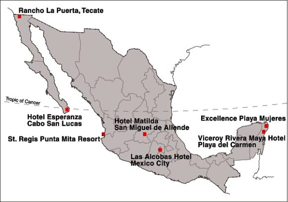
Location of Mexico's Top Seven Hotels

Location of Mexico’s Top Seven Hotels

Mexico’s top hotel (#15 in the rankings) was the Viceroy Rivera Maya hotel, in Playa del Carmen (Quintana Roo). It was joined in the top 100 by Rancho La Puerta in Tecate (Baja California), St. Regis Punta Mita Resort (Nayarit), Las Alcobas hotel (Mexico City), Hotel Matilda in San Miguel de Allende (Guanajuato), Hotel Esperanza in Cabo San Lucas (Baja California Sur) and the Excellence Playa Mujeres (Quintana Roo).

In related news, Grupo Posadas is investing one billion dollars over the next three years to open 49 new hotels, many of them in the firm’s Fiesta Americana chain. Meanwhile, at the opposite end of the hotel spectrum, Motel 6, the “McDonald’s of the hotel industry”, which has 1,200 locations in the USA and Canada, is opening 30 hotels in Mexico within the next three years.

The operator of the Motel 6 chain, G6 Hospitality, will introduce both its brands: Motel 6 and Estudio 6 (designed for extended stays) during its first foray into Latin America. The first of the new hotels will open in Salamanca (Guanajuato) in late-2015, with additional locations to follow, including Mexico City, Monterrey and several resort destinations.

Related posts:

Christmas in Mexico, according to one news agency

 Other  Comments Off on Christmas in Mexico, according to one news agency
Jan 252015
 

According to its website, “The QMI Agency is French and English Canada’s leading news reference for daily, intermittent and event-driven needs. Its offering most notably includes texts, images, videos and other interactive content.”

QMI’s Facebook page promotes its graphics department which “creates infographics for use throughout our chain” and boasts that “QMI Agency provides reliable, complete and up-to-the-minute news coverage over a full range of platforms.” And, indeed, many of the infographics shown on its Facebook page are very well designed, interesting, colorful and informative.

QMI-Christmas

Infographic from Niagara Advance newspaper for 25 December 2014

However, this infographic attributed to the QMI Agency, published in the Niagara Advance newspaper for 25 December 2014 (which Geo-Mexico happened to see while admiring Niagara Falls) was far less convincing. Entitled “Christmas around the world”, this particular infographic  took a “look at various traditions and customs”, and opened with a description intended to summarize Christmas in Mexico:

Mexico: Christmas dinner consists of oxtail soup with beans and hot chili, as well as roasted turkey and vegetables. Instead of receiving their gifts on Christmas Day, they get presents on Jan. 5, the eve of Twelfth Night.”

Hmm… really? As we have noted many times on Geo-Mexico, Mexican cuisine varies regionally. Even so, if any reader knows where “oxtail soup with beans and hot chili, as well as roasted turkey and vegetables” is the typical menu for Christmas, please let us know, to add to our list of regional delights.

As for presents being received on “Jan. 5, the eve of Twelfth Night”, err… no. The Mexican tradition of gifts on Three Kings Day involves Mexican children stuffing shoes (or a  box) with straw, and leaving them outside their bedroom door on the night of 5 January, in anticipation of finding gifts (new toys) the following morning, the morning of 6 January, Three Kings Day.

Related posts

Tourist numbers for Cancún, 2000-2014

 Updates to Geo-Mexico  Comments Off on Tourist numbers for Cancún, 2000-2014
Jan 212015
 

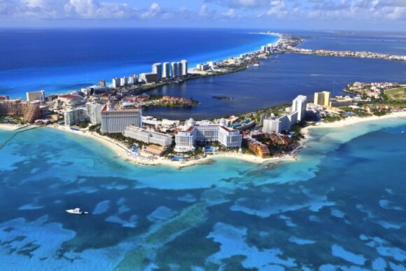
The table shows the number of tourists (national and international) visiting Cancún, Quintana Roo, Mexico, 2000-2013.

Cancún by Arthur Gonoretzky (Flickr)

Cancún by Arthur Gonoretzky (Flickr)

From 2000 until 2011, tourist numbers fluctuated between 2.8 and 3.3 million. Since 2011, tourist numbers have risen sharply, to 3.6 million in 2012, 4.1 million in 2013 and a preliminary estimate of 4.3 million for 2014.

YearNumber of touristsYearNumber of tourists
20003 043 00020083 265 591
20012 986 00020092 878 811
20022 826 00020103 015 690
2003n/a20113 115 177
2004n/a20123 642 449
20053 072 00020134 093 942
2006n/a20144 300 000 (estimate)
20073 004 8022015?

Cancún currently has more than 3000 condominium units and more than 35,000 hotel rooms. According to the first draft of the Programa de Desarrollo Urbano del Centro de Población Cancún 2014-2030, the city could have as many as 46,000 hotel rooms by 2030.

This projection is well below the earlier estimate, made in 2013, of 64,000 rooms by 2030, but the new figure is claimed to be more in line with planned improvements to local water supply. The development of Cancún has often been criticized for paying insufficient attention to considerations of urban density, water supply and environmental impacts.

 Related posts:

The Codex Mendoza, a key resource about Aztec times, can now be viewed online

 Books and resources  Comments Off on The Codex Mendoza, a key resource about Aztec times, can now be viewed online
Jan 192015
 

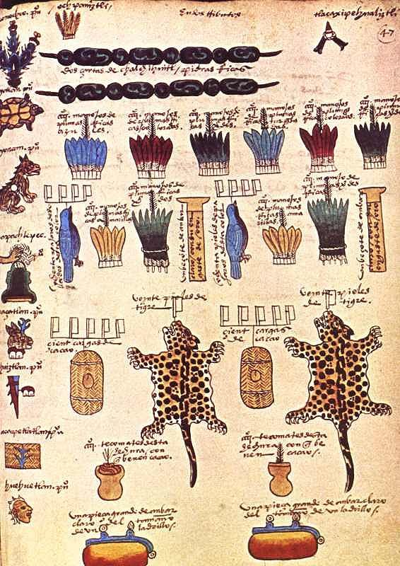
The Codex Mendoza, which we have referred to in several previous posts, can now be viewed via an amazing online interactive resource organized by INAH, Mexico’s National Institute of Anthropology and History, in association with Oxford’s Bodleian Library and King’s College, London.

Compiled in 1542, and richly illustrated, the Codex Mendoza is one of the key primary sources from Aztec times. It was completed at the instigation of Spanish viceroy Antonio de Mendoza and provides exquisite details about Aztec history, the expansion of their “empire” and the territorial tributes that they received from every quarter of their dominions. The Codex also chronicles daily life and social dynamics.

Tribute page from the Codex Mendoza

Tribute page from the Codex Mendoza

The interactive online version has images of the entire document and allows viewers to mouse-over the original text for translations into English or modern Spanish. Clicking on individual images offers more detailed explanations and information.

The digital codex can be viewed online, or downloaded through Apple’s App Store as a 1.02-gigabyte app.

The original Codex Mendoza resides in the library of Oxford University.  (The ship carrying it from New Spain (Mexico) back to Spain in colonial times was attacked by French buccaneers. The booty was subsequently divided up, with the Codex eventually reaching the university library.)

The online Codex Mendoza is  a truly amazing resource. Hopefully, some of the other Mexican codices that currently reside in Europe, too also be “virtually repatriated” in the near future, making it much easier for Mexican scholars to consult them.

Related posts:

Jan 132015
 

At this time of year, Mexico attracts millions of visitors seeking to escape the cold weather further north. The vast majority of visitors will never experience any problem during their travels in Mexico, but both the US State Department and Canadian government continue to issue regular warnings to those considering travel in Mexico. Some of these warnings are specific to certain stretches of highway; others are broader and focus on cities or regions. Click below for the current US travel warnings related to Mexico.

  • Current US Travel Advisory for Mexico

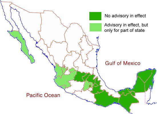
The states left white on the map below all have advisories in effect (as of mid-January 2015) for most or all of the state in question. For the states shaded light green, only small parts of the state have advisories in place, while no advisories are currently in place for those states shaded dark green.

US Travel Advisory Areas, December 2014

US Travel Advisory Areas, December 2014: All states, other than those colored dark green, have travel advisories in place for at least part of the state

The Canadian government offers its own travel warnings for Mexico:

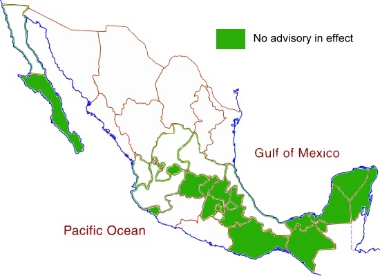
The Canadian advisories apply to all those states left white on the map below. States shaded dark green have no travel advisory in effect so far as the Canadian government is concerned.

Canadian Travel Advisory, November 2014. No advisory in effect for states colored dark green.

Canadian Travel Advisory, November 2014. No advisory in effect for states colored dark green.

The most obvious difference between the maps is that the US State Department is relatively unconcerned about the states of Jalisco and Nayarit, while the Canadian authorities have included them in a regional advisory.

States shaded dark green on both maps are areas where the US State Department and the Canadian government have no serious concerns about travel safety. These states, where travel is considered safe, include Guanajuato (including the cities of Guanajuato and San Miguel de Allende), Querétaro (including Querétaro City), Hidalgo, Puebla (including Puebla City), Oaxaca (Oaxaca City, Puerto Escondido and Huatulco), Chiapas (Tuxtla Gutiérrez and San Cristóbal de las Casas), Tabasco, Campeche, Yucatán (Mérida) and Quintana Roo (Cancún, Riviera Maya).

As always, tourists visiting Mexico and traveling within Mexico are advised to be cautious about visiting rural areas (especially in states where travel warnings are in place), to check local sources such as web forums for updates on the latest conditions, and to avoid driving at night.

Safe travels! Enjoy your trip!

Related post

The Mexican tradition of Three Kings Day

 Other  Comments Off on The Mexican tradition of Three Kings Day
Jan 062015
 

Unlike the USA and Canada, where gifts are usually exchanged on Christmas Day (25 December), the original tradition in Mexico over the Christmas season was to exchange presents on Three Kings Day (Día de los Reyes, 6 January). In the Christian calendar, 6 January marks the Feast of the Epiphany, the day when the magi arrived in Bethlehem with their gifts for the infant Jesus. In homage to this occasion, Mexican children would dutifully stuff the largest shoes (or box) they could find with straw, and leave them outside their bedroom door on the night of 5 January, in anticipation of finding new toys the following morning.

Rosca de Reyes

A typical family-sized Rosca de Reyes

Three Kings Day is still very much a family day throughout Mexico. In the late afternoon or early evening, it is traditional for the whole family to share a rosca. Roscas are ring-shaped loaves of sweet bread, sold to be eaten on special occasions. The roscas for Three Kings Day each contain a small muñeco (doll). These muñecos were originally ceramic, but are now more usually plastic. The recipient of the piece of rosca containing the muñeco has to throw a party on 2 February (Candlemas day, Día de la Candelaria) for all those present at the sharing of the rosca. It is customary to provide tamales to feed everyone gathering on Candlemas day.

Cristina Potters’ outstanding blog Mexico Cooks! includes a comprehensive account of the significance of the cuisine associated with Three Kings Day and Candlemas Day,

In the 20th century the Three Kings Day tradition in some regions of Mexico broke down in the face of the enormous consumer-oriented publicity from north of the border, which stressed Christmas (rather than Epiphany) gifts. Some especially greedy Mexican middle- and upper-class children claim that their parents and grandparents should not only preserve the old customs but also embrace the new version, and therefore hope to receive gifts on both days!

Nuevo León’s unusual shape

 Other  Comments Off on Nuevo León’s unusual shape
Jan 032015
 

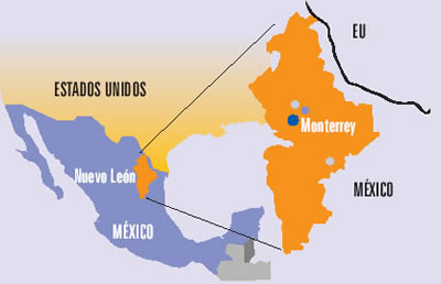
The northern state of Nuevo León is an industrial powerhouse, centered on Monterrey, Mexico’s third-largest city. The state’s shape on a map is unusual in more ways than one. The state has a long north-south axis and is very narrow from west to east. The strange indentation south of Monterrey is largely determined by relief. The peaks of the mountains on the Nuevo León side of that state boundary comprise a National Park, the Parque Nacional Cumbres de Monterrey.

Source: Universidad Autónoma de Nuevo León (UANL)

Source: Universidad Autónoma de Nuevo León (UANL)

Perhaps the strangest aspect of the shape of Nuevo León is the peculiar extension that forms the state’s north-eastern extremity (see map above). This small section of the state, about 15 km across, is sandwiched between the states of Coahuila and Tamaulipas, and extends to the Río Bravo and the U.S. border. The reason for this particular extension must date back a long time since it is clearly shown on this 1824 map of Mexico.

(Note that the shape of the neighboring state of Tamaulipas, with its lengthy extension north-west paralleling the US border, made much more sense in the early nineteenth century before the current international boundary was established).

While we’re not sure of the precise timing or reasons for the “neck” of land that gave Nuevo León access to the Río Bravo even before the current international boundary was fixed, it has certainly brought the state some benefit in recent decades in terms of economics and trade. Nuevo León is the smallest of the combined ten “border states” in the USA and Mexico.

A closer look at the Google Map image (above) of this area shows the border crossing of Laredo-Colombia across the Solidarity International bridge. Colombia is the name of the small grid-pattern town on the Mexican side, just west of the crossing.

Zooming in on the area of the crossing reveals the distinctive street pattern of a major border crossing, with extensive parking and loading areas.

The 371-meter-long (1216 ft) bridge has eight lanes for traffic and two walkways for pedestrians. It is one of four vehicular international bridges close to the city of Laredo, Texas. The community of Colombia and the international bridge were built to give Nuevo León its only international “port” for direct trade to and from the USA.

Related posts:

A Happy New Year to all our readers!

 Other  Comments Off on A Happy New Year to all our readers!
Jan 012015
 

We had no idea when we first published Geo-Mexico, the geography and dynamics of modern Mexico, and started this associated blog, how many readers we would reach.

Geo-Mexico-ThumbnailOn the one hand, very few U.S. or Canadian universities have courses devoted specifically to Mexico. There are quite a number of geography courses with titles such as “The Geography of Mexico, the Caribbean and Central America”, or “The Geography of Latin America”, but very few that focus mainly or solely on Mexico. This is unfortunate and means that most geography students graduating from USA universities will have only a partial knowledge, at best, of their southern neighbor. It also means that Geo-Mexico was not adopted by as many university courses as we might have hoped.

On the other hand, the book has been used in several courses that were not part of its target market, including courses in “The Politics of Mexico” and at least one International Affairs program. Equally, it has exceeded our expectations in providing a basic guide for non-specialists interested in getting a better knowledge of Mexico; the frequent feedback from readers has been overwhelmingly positive and gratifying. (Please keep it coming!)

The blog has proved to be very popular, and its audience continues to grow ~ don’t forget to recommend it to friends and colleagues. We welcome all comments and suggestions for future posts. We also welcome 400-800 word submissions (which will be published with your byline), but please contact us first.

Maps from Geo-Mexico have been included in many academic publications and a number of graduate theses. Publications that referred to the book, and/or blog, cover an amazing range of topics. A random sampling includes:

  • “Environmental risk, resilience and migration: implications for natural resource management and agriculture” in Environmental Research Letters  (2012)
  • “Texas and Mexico: Sharing a Legacy of Poverty and Neglected Tropical Diseases” in PLoS Neglected Tropical Diseases (2012)
  • “Zapatista Autonomy in Cartel Mexico: Preserving Smallholder Viability”, in Culture, Agriculture, Food and Environment (2011)
  • “NAFTA: The Mexican Economy, and Undocumented Migration” a research paper of Naval War College Newport, RI, Joint Military Operations Dept. (2011)
  • The Future of Entrepreneurship in Latin America (Palgrave Macmillan, 2012)
  • “Climate Change, Migration and Security, Best Practice Policy and Operational Options for Mexico”, an Interim Report from the Royal United Services Institute, Whitehall, London (2012)
  • “Vulnerability and Surviving Pattern of Elderly Migrants in Urban Mexico”, in Journal of Sociological Research (2012)
  • OECD Reviews of Risk Management Policies: Mexico 2013 Review of the Mexican National Civil Protection System (OECD 2013)

To all our readers, thanks for your support, and we wish you all a

Happy New Year! ¡Feliz año nuevo!

The mystery of the Alarcon Rise

 Updates to Geo-Mexico  Comments Off on The mystery of the Alarcon Rise
Dec 292014
 

Geologists have discovered that some strange things are happening off the southern coast of the Baja California Peninsula.

In essence, while most of Mexico rests on the North American plate, the Baja California Peninsula is on the gigantic Pacific plate. The Pacific plate is moving slowly northwest and the pressures in the zone where these two plates intersect, under the Sea of Cortés (Gulf of California), has caused a complex series of parallel faults which (further north) link to the California’s San Andreas Fault system. Thus, the Sea of Cortés is an area of heavy seismic activity.

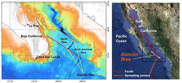
The Alarcón Rise is a 31-mile-long (50 kilometer) spreading center at the mouth of the Gulf of California. Along ocean spreading ridges like the Alarcón Rise, the seafloor is splitting apart as lava wells up from underneath. Credit: (c) 2012 MBARI

Location of the Alarcón Rise. Credit: (c) 2012 MBARI

The Alarcón Rise (see map) is a 50km (30 mi) long “bump” under the Sea of Cortés. New seafloor is being continuously created along the Alarcón Rise as undersea magma rises to the surface and cools to become lava. As the plates continue to move, this lave is then carried away to either side of the Alarcón Rise, allowing fresh lava to take its place, and so on. The rate of sea-floor spreading here is a relatively slow 5 cm (2 in) a year.

The Alarcón Rise has been studied in considerable detail by geologists attached to the Monterey Bay Aquarium Research Institute (MBARI) in California. Using a sonar-mapping robot, they discovered new deep-sea hydrothermal vents.

But their most surprising find was a “Weird Underwater Volcano.

In most zones of sea-floor spreading, the lavas are relatively low in silica and therefore free-flowing. Such lavas are known, on account of their chemistry, as “basic” lavas. (Lavas higher in silica, known collectively as acid lavas, tend to be more viscous and flow less easily. Acid lava volcanoes tend to erupt far more explosively than basic lava volcanoes.)

The curiosity of the Alarcón Rise is that while the vast majority of lava flows along the ridge are basic (basalt) lavas, those associated with at least one volcano are clearly acidic, not basic.

Researchers used a remote-control vehicle to collect samples and explore the volcano, which is 2375 m (7800 ft) below the surface. Samples of the lava show that it is primarily rhyolite with some dacite, with a silica content of up to 77%, the highest of any rock ever found along a mid-ocean ridge, according to Brian Dreyer, a geochemist at the University of California, Santa Cruz. The volcano with acid lava forms a small dome, about 50 meters (165 ft) in height and covers an area of about 1200 meters by 500 meters (4000 feet by 1640 feet). The dome is probably several thousand years old.

The lavas solidified quickly to form angular chunky blocks, some of which then rolled down the sides of the rise to form talus (scree). The individual blocks can be as large as cars or small houses.

The findings suggest that this particular volcano could give rise to hazardous eruptions. It is only 100 km (60 mi) from land and very close to the major tourist areas fringing the coast of Baja California Sur. Any major explosive eruption from this volcano could also cause a tsunami with the potential to devastate settlements on both coasts of the Sea of Cortés (Gulf of California).

Geologists are still working on trying to fully explain this apparent anomaly in lava composition. They have already discarded several ideas, and their current hypothesis is that the magma source was at some point contaminated by seawater, resulting in an unusually high concentration of volatiles such as water, sulfur and chlorine.

Related posts:

Mexico’s vehicle industry

 Teaching ideas, Updates to Geo-Mexico  Comments Off on Mexico’s vehicle industry
Dec 272014
 

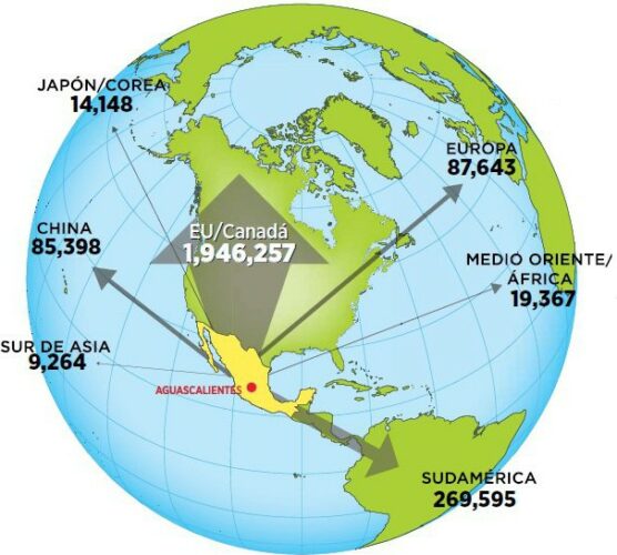
Mexico is one of the world’s “Top Ten” countries for vehicle production and for vehicle exports. In 2014, it has overtaken Brazil to become the world’s 7th largest vehicle producer and fourth largest exporter. 80% of Mexico’s production of around 3.3 million vehicles in 2014 were made for export. The trade surplus generated by the automotive sector exceeded 47 billion dollars in 2014.

auto-exports-forbes

Mexico’s vehicle exports in 2014. Credit: Forbes, México.

The industry attracts large amounts of Foreign Direct Investment (FDI). Vehicle assembly plants provide around 65,000 jobs, with a further 85,000 employed in distributorships nationwide and a whopping 450,000 employed in the autoparts sector.

The autoparts sector along produces items worth $80 billion/year, but Mexico also has to import components made elsewhere worth a further $35 billion. Clearly, this offers some opportunities for additional investment aimed at import substitution. Most of the opportunities are likely to be for Tier 2 companies. It is customary to divide the autoparts sector into three distinct parts: OEM, Tier 1 and Tier 2. OEM (Original equipment manufacturer) refers to companies that make a final product for the consumer marketplace (eg Volkswagen). Tier 1 companies are direct suppliers of components to OEMs, and Tier 2 companies are the key suppliers of parts or raw materials to Tier 1 suppliers.

Total production in 2014 topped the 3 million barrier, and the Mexican Automotive Industry Association (AMIA) believes production could reach 4 million units by 2015 and 5 million by 2020.According to  AMIA, the best selling models on the domestic market are the Aveo (GM), Jetta (VW), Versa and Tsuru (both Nissan).

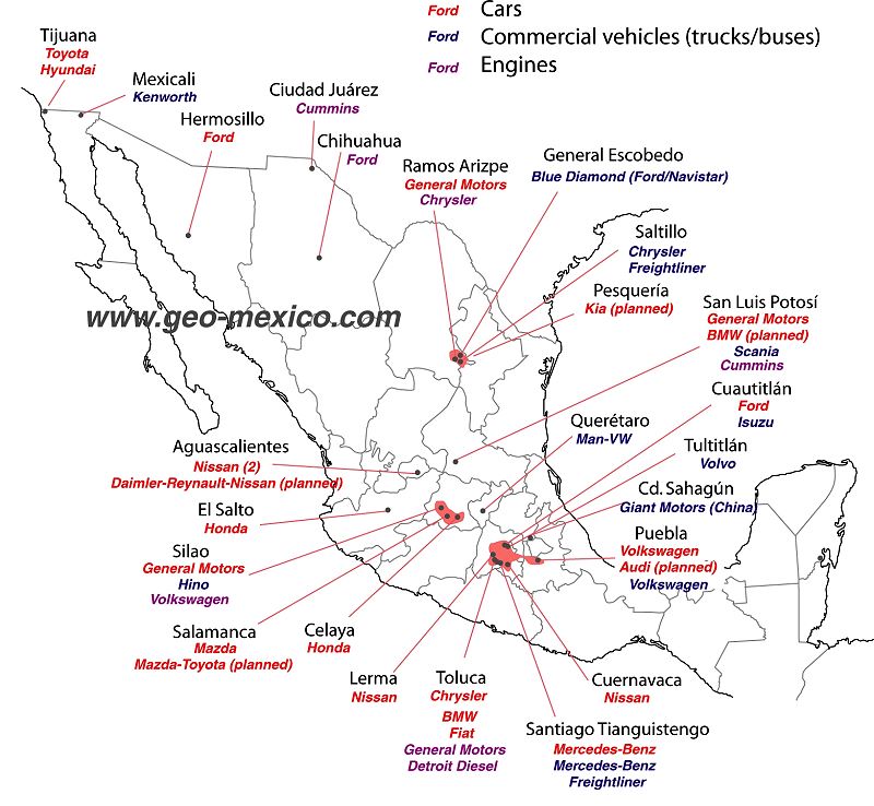
There are about 30 vehicle assembly plants in Mexico, manufacturing many brands of cars and trucks (see map). In addition, there are 1200 firms specializing in making parts for vehicles.

Vehicle manufacturing firms that have announced or confirmed major new investments during 2014 include:

  • Chrysler – 1.25 billion dollars to expand its assembly plant in Saltillo and manufacture a new line of Tigershark engines.
  • Nissan – to open its second plant in Aguascalientes.
  • Mazda – an additional 120 million dollars for its plant in Salamanca (Guanajuato), where it will manufacture several Mazda models as well as one Toyota model.
  • GM – investments worth 690 million dollars, divided  between its plants in Silao (Guanajuato), San Luis Potosí and Toluca (State of México).
  • Audi – about to open a 1.3-billion-dollar plant in San Jose Chiapa, near Puebla.
  • VW – 700 million dollars investment to adapt production lines in Puebla to produce its redesigned Golf hatchback.
  • Kia – plans to build a $1 billion vehicle assembly plant at Pesquería in the state of Nuevo Leon (scheduled to open in 2016) to produce up to 300,000 vehicles a year. The new plant is expected to generate a further 1.5 billion dollars in investment from firms seeking to join Kia’s supply chain.

This map is an updated version of the map we included in Where are Mexico’s vehicle assembly plants located? (2011).

Vehicle assembly plants in Mexico, 2014

Vehicle assembly plants in Mexico, 2014. Credit: Tony Burton/Geo-Mexico; all rights reserved.

As the map shows, certain areas of Mexico have attracted more investment in vehicle assembly plants than other areas. The two largest existing concentrations are focused on Toluca in the State of México, and on Saltillo-Ramos Arizpe in northern Mexico. However, the fastest growing cluster is in the central state of Guanajuato.

Virtual visit to the Chrysler plant in Saltillo (video, no commentary):

For a series of discussion questions related to this map and the vehicle assembly industry, see our earlier post – Where are Mexico’s vehicle assembly plants located?

Related posts:

Seasonal greetings from Geo-Mexico!

 Other  Comments Off on Seasonal greetings from Geo-Mexico!
Dec 242014
 

Geo-Mexico wishes all its readers the warmest seasonal greetings.

tenango-de-flores-xmas-tree2

The photo shows Mexico’s only floating Christmas Tree. It can be seen near Tenago de las Flores in the municipality of Huachinango in the northern part of the state of Puebla. The 15-meter-high tree, with Christmas lights, stands on a wooden platform atop a raft of 32 metal drums in the middle of the Tenango reservoir, upstream from the Necaxa Dam, Mexico’s first hydroelectric project, dating back to 1905. The tradition started only three years ago when local residents decided that a floating Christmas tree might prove to be a tourist attraction.

The 10-min video below shows the “light up” of the tree early this month, complete with music and singing.

Tenango de las Flores has been more famous in the past for its large-scale production of flowers (floriculture) and for its annual Flower Festival, as well as for featuring in an award-winning 1957 film called Tizoc: Amor Indio, starring María Félix and Pedro Infante. The film won the Golden Globe Award for Best Foreign Language Film at the 15th Golden Globe Awards (1958).

tenango-de-flores-xmas-tree-day

Related posts:

Mexico City looks to expand its metro network

 Mexico's geography in the Press  Comments Off on Mexico City looks to expand its metro network
Dec 222014
 

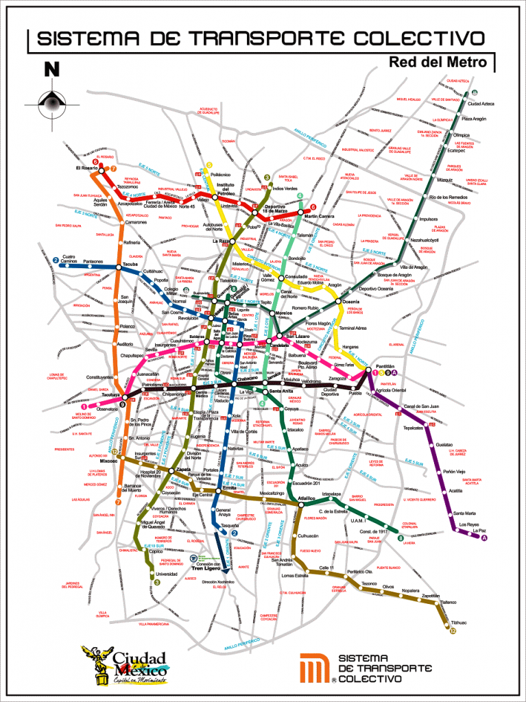
Plans to expand Mexico City’s metro network, announced by the federal government, will require investments totaling around 2.8 billion dollars. The first contracts are expected to be awarded next year, with most projects due to be completed by 2018, the final year of this administration.

Mexico-City-Metro-MapThe major proposals affect three metro lines:

Metro Line A (Pantitlán to La Paz) will be extended 12.9 kilometers to the southeast, with six new intermediate stations, to Chalco in the state of Mexico, at a cost of about 1 billion dollars. [Update – March 2016 – officials have described the proposal to extend line A as “cancelled“]

The lengthening of Metro Line 4 (Martín Carrera to Santa Anita) northeastwards to reach Tepexpan will require investments of 1.5 billion dollars and add 19 intermediate stations as well as a terminal in Tepexpan. It will have improved links to other Metro and Metrobús lines.

Metro Line 12 will be extended northwards beyond its present terminus in Mixcoac to include new two intermediate stations and a new terminal station in Observatorio. This line will improve transit through Observatorio for passengers, including those using the future high-speed train link between Toluca and Mexico City.

Note that the elevated (above ground) southern section of Metro Line 12 between Tlahuac and Atlalilco stations, closed for repairs since March 2014, remains closed and is not expected to reopen until the second half of 2015. A replacement bus system has been established between those stations.

Useful links:

Related posts:

The production of Christmas trees in Mexico

 Other  Comments Off on The production of Christmas trees in Mexico
Dec 182014
 

According to consumer surveys, only one out of every five Mexican households decorates a natural Christmas tree during the holiday season; the other 80% of households decorate artificial trees. About 75% of natural trees are bought from traditional retailers, with the remaining 25% purchased from informal street vendors. Almost all purchases of natural Christmas trees are made between 10 December and 25 December.

As of mid-December 2014, sales of trees are reported to be down on previous years. Retailers claim that the prices for imported trees (ranging from 330 pesos (about 25 dollars) for a 1-meter-high tree to 1,500 pesos (110 dollars) for a large tree) have led to greatly diminished demand. Prices for domestically grown trees range from about 100 to 1,000 pesos.

The total annual demand for natural Christmas trees is about 1.8 million. Mexico currently imports about 1 million trees a year, almost all from the USA and Canada. Annual imports are worth about $12 million. Imports are governed by strict standards, last revised in 2010, to ensure that no unwanted pests or diseases are brought into the country.

As of mid-December, at least 5500 trees had failed the health inspection at the border and had been returned to the USA. Officials from Mexico’s Federal Environmental Protection Agency (Procuraduría Federal de Protección al Ambiente, Profepa) identified several problems in shipments of Douglas Fir and Noble Fir trees. At Tijuana, one shipment of Douglas Fir was found to be infected a resin moth (Synanthedon sp.), and one with flatheaded fir borer (Buprestidae). In Mexicali, a shipment of Douglas Fir was infested with the Douglas-fir Twig Weevil (Cylindrocopturus furnissi), while in Nogales, imported trees were found to be accompanied by unwanted European Paper Wasps (Polistes dominula). None of these pests are normally found in Mexico.

Mexicali is the busiest border crossing in terms of Christmas tree imports, accounting for 35% of the total, followed by Tijuana (25%), Nogales (16%), Colombia (15%), Nuevo Laredo (4%), San Luis Río Colorado (3%), Reynosa (1%) and Puente Zaragoza-Isleta (in Chihuahua) (0.4%).

In the 1970s and 1980s, most natural Christmas trees sold in Mexico came from Mexico’s natural forests. Beginning in the 1990s, specialist Christmas tree nurseries and plantations were started.

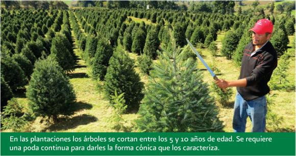
Pruning young Christmas trees in Mexico

Pruning young Christmas trees in Mexico to ensure they keep a good shape. Credit: CONAFOR.

According to the National Forestry Commission (CONAFOR), Mexico has almost 17,000 hectares of land planted in Christmas trees. The area of Christmas trees has increased very rapidly in recent years. This year, CONAFOR has provided some degree of financial assistance to farmers with 4,551 hectares of tree plantations in 18 states.

The main areas of Christmas tree plantations are in the interior highlands in the states of Mexico, Veracruz, Nuevo León, Mexico D.F., Puebla, Michoacán, Durango, Coahuila and Guanajuato. These states share temperate climate conditions and are close to the main markets in major cities.

The most common species grown in Mexico are Mexican White Pine (Spanish: Pino ayacahuite), Douglas Fir (Abeto douglas), Mexican Pinyon (Pino piñonero), Sacred Fir (Oyamel) and Aleppo Pine (Pino alepo).

Trees are harvested at between five and ten years of age. Mature plantations of Christmas trees can generate revenue of between 300,000 pesos and 500,000 pesos ($23,000-$38,000) for each hectare. This means that Christmas tree farming has become a profitable form of sustainable development in some rural communities, offering greater profit potential than using the same land to grow traditional rain-fed crops.

The planting of Christmas trees is supported by CONAFOR’s ProArbol program, which offers landowners incentives to conserve, restore, and sustainably exploit forest resources. CONAFOR claims this helps to limit urban sprawl, and counteract forest clearance for arable land, as well as to increase the capture and storage of carbon, thereby mitigating climate change. In addition, conifer plantations generate rural employment, reducing the effects of one of the key “push” factors behind rural-urban migration.

Note: This is an updated version of a post that was first published in 2012.

Main source:

USDA Foreign Agricultural Service GAIN report: Mexico: Christmas Trees, by Dulce Flores, Vanessa Salcido, and Adam Branson. 12 May 2011.

Related posts:

Dec 152014
 

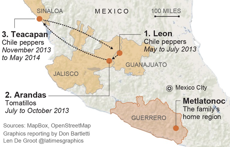
A week ago, we highlighted the first of a series of four articles in the LA Times about the living and working conditions faced by migrant farmworkers in Mexico as they harvest crops that end up on dinner tables not only in Mexico, but also in the USA. The other three articles in the series are just as disturbing, but make for compelling reading.

la-mexico-farm-labor-map-alejandrina-2014-1212

The pilgrimage of 12-year-old Alejandrina Castillo during a single year as she accompanies her migrant farmworker parents. Credit: LA Times

The journalist and photographer responsible for this series of articles deserve high praise for their persistence and determination in exposing some of the “dirty little secrets” of Mexico’s agribusiness sector.

Links to the full series on the LA Times website:

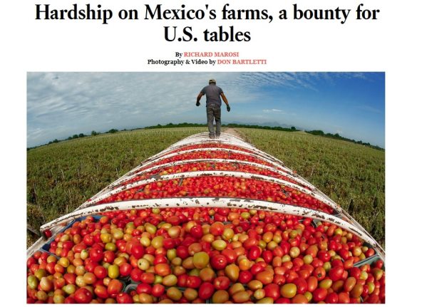
Part 1: Hardship on Mexico’s farms, a bounty for U.S. tables – Farm exports to the U.S. from Mexico have tripled to $7.6 billion in the last decade, enriching agribusinesses, distributors and retailers. But for thousands of farm laborers south of the border, the boom is a story of exploitation and extreme hardship.

Part 2: Desperate workers on a Mexican mega-farm: ‘They treated us like slaves’ – A raid exposes brutal conditions at Bioparques, one of Mexico’s biggest tomato exporters, which was a Wal-Mart supplier. But the effort to hold the grower accountable is looking more like a tale of impunity.

Part 3: Company stores trap Mexican farmworkers in a cycle of debt – The company store is supposed to be a lifeline for migrant farm laborers. But inflated prices drive people deep into debt. Many go home penniless, obliged to work off their debts at the next harvest.

Part 4: Children harvest crops and sacrifice dreams in Mexico’s fields– About 100,000 children under 14 pick crops for pay at small- and mid-size farms across Mexico, where child labor is illegal. Some of the produce they harvest reaches American consumers, helping to power an export boom.

Related posts:

Access to safe water is a human right in Mexico

 Mexico's geography in the Press  Comments Off on Access to safe water is a human right in Mexico
Dec 132014
 

Earlier this year, David Korenfeld, the director of Mexico’s National Water Commission (Conagua), was chosen to head the inter-governmental council that oversees UNESCO’s International Hydrological Program (IHP). The IHP is the only inter-governmental program of the U.N. system devoted to water research, water-resources management, and education and capacity building.

In his acceptance speech, Korenfeld called for “greater synergy between decision makers and specialists to combine theory and practice” and stated that “significant challenges remain [in the water sector], including integral basin management, application of the human right to water and water security and sustainability in the context of climate change.

Recent events demonstrate that Mexican courts are happy to uphold the view that water is a basic human right. The 5 Dec 2014 issue of the OOSKAnews, a newsletter dedicated to water industry professionals, included the following short piece about a landmark recent decision by Mexico’s Supreme Court that represents the first ever Supreme Court decision in Mexico upholding the nation’s stance that “water is a basic human right.”

The Supreme Court has for the first time awarded an “amparo” (similar to an injunction, a remedy for the protection of constitutional rights), based on the human right to water.

In this case, members of the court unanimously sided with Lidia Velázquez Reynoso, a resident of the Ampliación Tres de Mayo area in the municipality of Xochitepec, in the state of Morelos.

In their ruling, the court said authorities must meet their obligation to provide Velázquez’s residence with “access, availability, and sanitation of water for personal and domestic consumption in a sufficient, safe, acceptable, and affordable form.” A lower court had already ruled in favor of Velázquez, but the case was appealed.

The Supreme Court said responsible authorities had failed to guaranteed regular delivery of water, since merely connecting Velázquez’s residence to the water system was not good enough. Water quality and volume must also be taken into account. The court said that the water must meet World Health Organization standards, and the volume provided must be at least 50 to 100 liters per person per day.

The court ordered authorities to not only deliver the water to Velázquez, but also to remit records showing that the water meets national and international standards.

(OOSKAnews, 5 December 2014)

Related posts:

The geography of dengue fever in Mexico

 Updates to Geo-Mexico  Comments Off on The geography of dengue fever in Mexico
Dec 112014
 

Preventing, diagnosing and treating dengue fever is a major public health issue in many parts of the world, including central America and Mexico. The disease is transmitted by mosquitoes. Infected patients develop a sudden high fever, usually accompanied by generalized body pain and a skin rash. The pain can be very severe, hence the disease’s common name of breakbone fever.

Several species of mosquito can transmit dengue, but female Aedes aegypti mosquitoes are the main transmitter of dengue in Mexico. These mosquitoes bite during the day, mostly in the period two hours either side of dawn and dusk. The mosquito bites an infected person and ingests blood with the dengue virus, which incubates in the mosquito for a period of 8 to 12 days. After that the mosquito can begin to transmit the virus by biting other people. From 5-7 days later any newly infected person is likely to have symptoms.

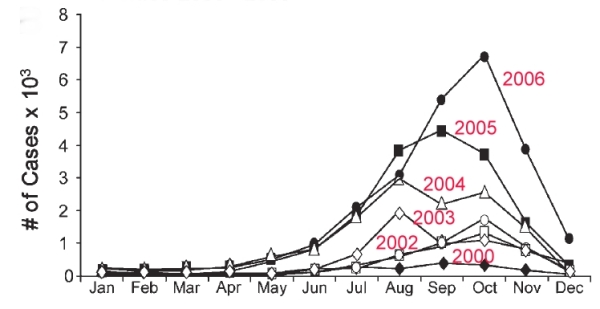
The graph below shows the monthly number of dengue cases in Mexico from 2000 to 2006. It is clear that most cases are reported between July and November, with very few cases occurring between December and May. This can be explained by Mexico’s climate. Almost of all of Mexico receives most of its rainfall between June and October. The mosquitoes that spread dengue need stagnant water to breed. There are far more small pools of water available for mosquito breeding in and immediately after the annual rainy season. Eliminating potential locations where water can collect and stagnate is an important element of dengue prevention programs.

Monthly incidence of dengue cases in Mexico, 2000-2006

Monthly incidence of dengue cases in Mexico, 2000-2006. Source: San Martín, Brathwaite et al (2014).

The graph also shows that the number of cases of dengue was increasing rapidly between 2000 and 2006. Indeed, numbers continued to rise until 2013 when more than 50,000 cases were reported for the year (an average of more than 4000/month). At first sight, this suggests that dengue prevention programs have not been very successful, but in fact the rise echoes what was happening worldwide. One possible, at least partial, explanation may be that changes in climate have allowed dengue mosquitoes to thrive in environments where they were previously scarce. People in such areas are unprepared for dengue; they may not have instituted prevention programs, and may have been slow to receive correct diagnosis. The migration of people affected by dengue from one region to another may also have helped the disease spread, provided there were host mosquitoes in the destination region.

The good news is that the number of dengue cases in Mexico in 2014 has fallen from its 2013 level by about 50%, so the dengue epidemic may finally be on the wane. As of 24 November 2014, 28,109 cases had been reported for the year, an average nationwide rate of 23.47 cases/100,000 people. Dengue is fatal in a relatively small number of cases, with 33 deaths reported in Mexico so far this year..

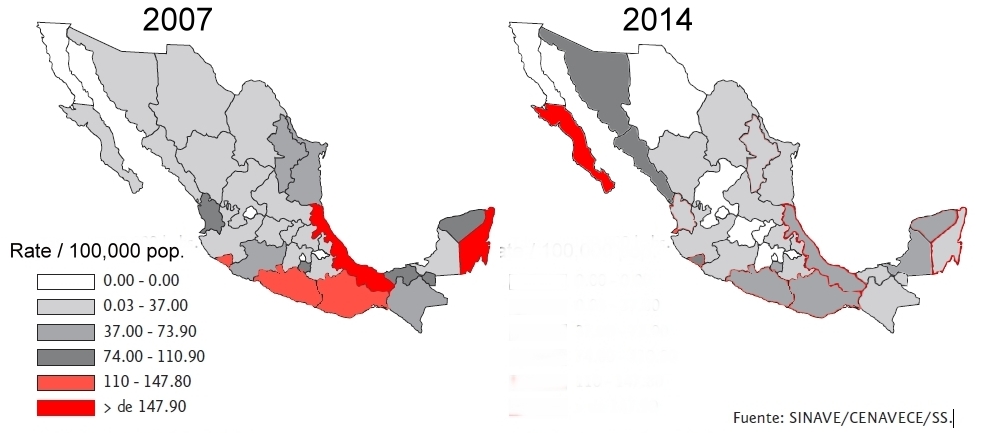
The total number of cases may finally be on the decline, but the figures for 2014, when looked at state by state, suggest that the spatial pattern of dengue cases in Mexico is changing. The two maps below compare the rate of cases per 100,000 people on a state-by-state basis for 2007 and 2014. (The color-coded key is identical for both maps).

Rates of dengue by state, 2007 and 2014

Rates of dengue by state, 2007 and 2014. Rates are cases / 100,000 population

In 2007, the highest rates of dengue were found in the states of Veracruz and Quintana Roo, with Oaxaca, Guerrero and Colima comprising the next category. (Those five states are the ones colored red on the 2007 map). At the other extreme, no cases were recorded in 2007 in the state of Baja California, or in several tiny states including Aguascalientes.

The pattern shown on the 2014 map is quite different. In general, rates of dengue at the state level have not increased in Mexico, but decreased. However, there is a clear shift in emphasis towards the north-west, where several states had much higher rates in 2014 than in 2007. The extreme example is Baja California Sur, where the rate for 2014 (up to 24 November) was a whopping 549.9 cases / 100,000 people, more than five times the rate registered in any other state. Equally apparent is the belt of low-rate states (from Chihuahua to the State of México) down the center of the country from the U.S. border to Mexico City. These states are at relatively high elevation where fewer mosquitoes are found.

The states of Baja California Sur, Veracruz, Sinaloa, Sonora and Guerrero account for 55% of the 28,109 confirmed cases of dengue fever reported in Mexico as of 24 November 2014.

Mexico’s Health Secretariat publishes maps of each state showing which municipalities have reported cases of dengue. These maps are updated weekly. The link is to a pdf document with maps for 2014 up to 24 November.

There is some good news. In 2015, Mexico will be the first nation in the world to get a new dengue vaccine, developed by French company Sanofi Pasteur. The company hopes to have manufactured more than 40 million doses by the first half of 2015, and has decided to introduce it first in Mexico, with the first vaccinations likely to be offered to the public late next year or early in 2016. In trials, the vaccine proved 60.8% efficient in preventing the disease.

Reference for graph:

José Luis San Martín, J.L., Brathwaite, O., Zambrano B, et al (2014): “The Epidemiology of Dengue in the Americas Over the Last Three Decades: A Worrisome Reality”; Am. J. Trop. Med. Hyg., 82(1), 2010, pp. 128–135

Related posts

Dec 082014
 

Every so often, a news article comes along which rattles our perceptions, causes us to think, and begs us to discuss big issues. This is one of those times.

Los Angeles Times reporter Richard Marosi and photojournalist Don Bartletti traveled across nine Mexican states, observing conditions and interviewing workers at some of the mega-farms that have powered the country’s agricultural export boom.

The resulting article, the first of a four-part series, was published yesterday in the Los Angeles Times, and offers lots of potential for serious discussions in geography classes around the world about agribusiness practices, supply chains, the persistence of inequalities, and a host of other issues. The article is accompanied by some great photographs and short, informative videos.

la-times-article

In “Hardship on Mexico’s farms, a bounty for U.S. tables“, Marosi and Bartletti find that thousands of laborers at Mexico’s mega-farms endure harsh conditions and exploitation while supplying produce for American consumers.

This is a must-read series for anyone interested in the Geography of Mexico, and we can’t wait to see the next three parts of this series.

Related posts:

Dec 062014
 

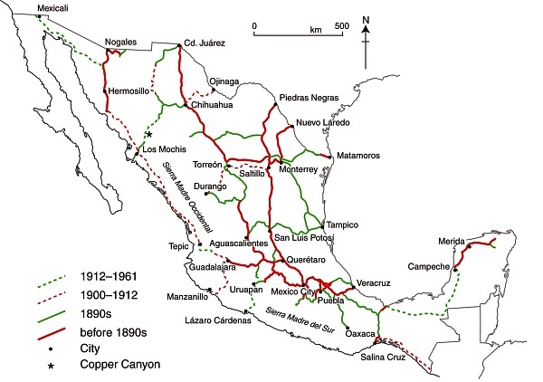
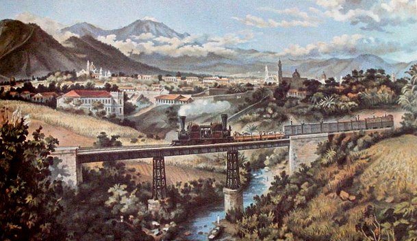
In the second half of the 19th century, the Mexican government undertook am ambitious railway building program that eventually connected Mexico City with the USA, as well as with ports on the Atlantic Ocean and Pacific Ocean

Since the privatization of the railway system in 1995, many lines have fallen out of use and passenger services have been all but abandoned, leaving hundreds of kilometers of disused track and isolating some rural communities from the nearest large city. Much of Mexico’s historic railway infrastructure now lies in ruins.

In the past decade, some former railway lines have been turned into walking and cycling trails. For example:

The state of Jalisco has started to recondition 120 kilometers of former railway routes as Green Route (Via Verde) trails for non-motorized traffic (hikers, cyclists, horse riders). Many of the old stations along these routes will be restored to provide essential services and exhibition space. The former train station in Ameca (on the extreme northern edge of the town) has been renovated to serve as the start of one of these routes, with exhibits focusing on the history of the railroad, local fiestas and the region’s haciendas. The lovely building, dating back more than a century, witnessed its last train in 1995.

Given that the railways played such a key role in the Revolution, enabling both sides to move troops quickly around the country, it is fitting that they are now the basis for this new revolution involving cultural tourism. (Western Mexico, A Traveler’s Treasury, p 61).

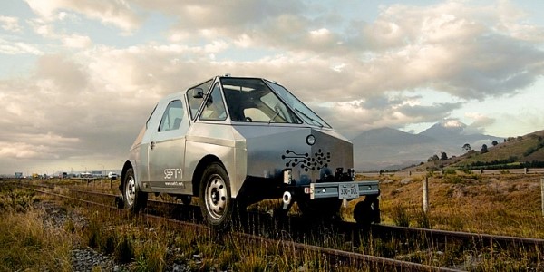
Others lines, elsewhere in Mexico, have been explored by two intrepid Mexican artists as part of an unusual geo-art project. Artists Ivan Puig and Andres Padilla Domene built a vehicle capable of traveling on train tracks and explored some of the country’s abandoned railway lines. As they went, they photographed hundreds of ruins and recorded hours of interviews with people they met. They later did something similar in Ecuador, but that’s another story.

Their striking silver road-rail vehicle is known as SEFT-1, where SEFT stands for Sonda de Exploración Ferroviaria Tripulada (Manned Railway Exploration Probe).

seft-1

The artists recorded their experiences in videos, photographs and collected objects. Interviewing people they met, often from communities isolated by Mexico’s passenger railway closures, they shared their findings online, where audiences could track the probe’s trajectory, view maps and images and listen to interviews.

Their first London (UK) exhibition, SEFT-1 Abandoned Railways Exploration Probe – Modern Ruins 1:220, was commissioned by The Arts Catalyst and presented at the Furtherfield gallery space in the heart of Finsbury Park. In the exhibit, the artists explore how the ideology of progress is imprinted onto historic landscapes and they also reflect on the two poles of the social experience of technology: use and obsolescence.

For this exhibition, the artists also invited British expert model railway constructors to create scale reproductions of specific Mexican railway ruins exactly as they had found them. One gallery became a space for the process of model ruin construction. The room’s walls displayed the pictures, documents, plans and other materials used as reference for the meticulously-elaborated models.

The Artists

Ivan Puig (born 1977, Guadalajara) has exhibited internationally in Mexico, Germany, Canada, Brazil and the USA. Puig, a member of the collective TRiodO (with Marcela Armas and Gilberto Esparza), lives and works in Mexico City.

Andrés Padilla Domene (born 1986, Guadalajara) has exhibited work in Mexico, the USA and Ecuador. His video work as director and producer with Camper Media includes documentaries, fiction films and TV shows.

Related posts:

Which states in Mexico are the most competitive?

 Maps, Mexico's geography in the Press  Comments Off on Which states in Mexico are the most competitive?
Dec 032014
 

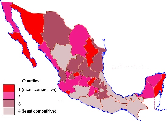
The Mexican Institute for Competitiveness (Instituto Mexicano para la Competitividad AC, IMCO) has published its annual analysis of the competitiveness of Mexico’s states. The report provides some interesting insights into which areas of Mexico are “most competitive” in business terms, defined as their capacity to attract and retain investments and a talented workforce.

This suggests a business environment that maximizes the socio-economic potential of both the business entities and individuals residing in a a specific area. It also suggests that any improved well-being (economic and social) will be maintained (sustained).

The index is based on 89 indicators in 10 sub-indices. The 10 major factors include the reliability and objectivity of the legal system, the sustainable management of the natural environment, the stability of macroeconomic policies, the degree to which society is non-divisive, educated and healthy, and the stability and functioning of the political system.

The latest report relies on 2012 data. Mexico’s basic pattern of competitiveness at the state level is shown in the map.

Mexico, 2014. Map: Tony Burton; all rights reserved

Competitiveness in Mexico, 2014. Map: Tony Burton; all rights reserved

The five most competitive states in Mexico are:

  • Federal District (Mexico D.F.)
  • Baja California Sur
  • Aguascalientes
  • Nuevo León
  • Querétaro

While a full analysis of why some states are more competitive than others is beyond the scope of this post, the single most striking aspect of this map is the persistent low degree of competitiveness of several of Mexico’s poorest states, such as Guerrero, Oaxaca and Chiapas.

In general, states in Northern Mexico are noticeably more competitive than those in Southern Mexico. Two areas on opposite coasts where tourism is extremely important to the local and national economy – Baja California Sur and Quintana Roo – are both very competitive.

Mexico’s economy and workforce are analyzed in chapters 14 to 20 of Geo-Mexico: the geography and dynamics of modern Mexico. Ask your library to buy a copy of this handy reference guide to all aspects of Mexico’s geography today! Better yet, order your own copy, which will still arrive in time for Christmas…

Related posts:

Mexico is the world’s leading exporter of beer

 Mexico's geography in the Press, Updates to Geo-Mexico  Comments Off on Mexico is the world’s leading exporter of beer
Nov 262014
 

For the fourth year running, Mexico was the world’s leading beer exporter in 2013, with beer exports reaching a record 2.2 billion dollars, a rise of 4.2% compared to 2012, and well ahead of both the Netherlands ($2.0 billion) and Belgium ($1.6 billion).

cerveza-victoria-bicentenaryMexico has become the leading supplier of beer to the USA and now accounts for almost 50% of that country’s beer imports. It is also the leading supplier to Australia, Chile, Guatemala, Argentina and New Zealand, as well as the third leading supplier to Canada and the fourth largest to China and Japan.

The two major beer producers in Mexico are Grupo Modelo and Cervecería Cuauhtémoc Moctezuma.

The leading export brand is Corona which reaches 180 countries around the world. Over the past decade, Mexico’s beer industry has grown at 2.5%/year and analysts expect this rate to quicken, predicting output will rise from 71 million hectoliters this year to 82 million in 2020.

In the USA, quite a few Mexican beers will be consumed this Thanksgiving Day… Happy Thanksgiving to all!

Related Posts:

Nov 232014
 

Many of the arts and crafts found in Michoacán date back to pre-Columbian times, but now incorporate techniques and materials that were brought from Europe and elsewhere. Many of the introductions occurred during the time of Vasco de Quiroga (ca 1470-1565), after whom the town of Quiroga, at the eastern extremity of Lake Pátzcuaro, is named.

Visitors to Michoacán area often amazed to discover that towns even only a few kilometers apart have developed completely different handicrafts, and that all the handicraft workshops in any one town seem to focus on making precisely the same items. If one workshop in a town specializes in wooden items, all the neighboring workshops appear to do the same. Just how did these very distinctive spatial patterns come about?

Craft market in Tzintzuntzan, Michoacan

Craft market in Tzintzuntzan, Michoacan

The answer to the oft-asked question, “Why does each town in Michoacán have its own handicrafts?”lies in the history of this area and, in particular, of the efforts almost five hundred years ago of one Spanish priest.

Who was Vasco de Quiroga?

Vasco de Quiroga trained originally as a lawyer. He later took holy orders and arrived in the New World in 1531, already in his sixties. He gained rapid promotion and six years later was appointed Bishop of Michoacán, with the express purpose of trying to clear up the mess left by Nuño Beltrán de Guzmán’s rampage through western Mexico, and to placate the bad feelings of the indigenous Purépecha populace.

Vasco de Quiroga based his approach on the Utopian principles espoused by Thomas More. He established a series of communities in the vicinity of Lake Pátzcuaro, the heart of Purépecha country, improved security, and set up hospitals and schools serving the local people.

Agricultural improvements

Recognizing the importance of agriculture, Vasco de Quiroga introduced European implements and methods as well as new crops, including wheat and other cereals, fruits and vegetables. Perhaps his most noteworthy introduction was the banana. The first bananas to be grown anywhere in Mexico were brought by Vasco de Quiroga from Santo Domingo in the Caribbean and planted in Tzintzuntzan.

Handicrafts

Alongside religious instruction, Vasco de Quiroga organized training in arts and crafts. His efforts quickly won over many of the local people who came to acknowledge that the hostility they had experienced from their first contacts with Europeans was not typical of all the newcomers. The kindly Bishop came to be sufficiently respected by them to be awarded the honorific title of “Tata” (“Father”) Vasco.

The local indigenous Indians had already developed the skills needed for varied ceramics, wood and leather products, copper items, and woven cotton and agave fiber textiles. They also used the local lake bulrushes (tule). Vasco de Quiroga introduced new techniques which allowed the artisans to multiply their production.

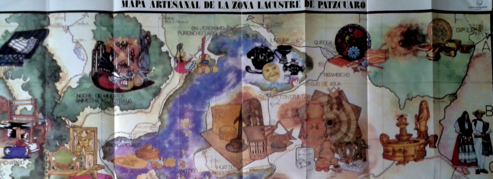
To encourage specialization, and limit direct competition between villages, “Tata” Vasco allocated specific crafts to specific places, a pattern that continues to the present. The particular handicraft developed in each village also reflects the availability of local raw materials such as bulrushes needed for mats, or clay for pottery. On account of the fine quality of local clays, the making of ceramics was encouraged in the villages of Tzintzuntzan, Patamban, Santa Fe de la Laguna, Capula and Pinícuaro. Ironworking and locksmithing were introduced in San Felipe de los Hereros; quilting and embroidery in San Juan de las Colcahas, and so on.

Section of tourist map showing some of handicraft towns near Lake Patzcuaro

Section of tourist map showing some of handicraft towns near Lake Patzcuaro

The arts and crafts skills in the villages around Lake Pátzcuaro and elsewhere in Michoacán have been passed down to this day, becoming more finely honed with each successive generation, producing craftsmen who are among the finest in the country. They are responsible for a truly amazing variety of handicrafts, fine art and furniture items.

Among the better known places to seek out particular handicrafts are:

  • Angangueo: woolen items
  • Cuanajo: wooden chests and furniture
  • Erongarícuaro: wooden furniture, earthenware
  • Ihuatzio: petate mats
  • Jarácuaro: palm hats (woven)
  • Paracho: guitars and stringed instruments
  • Pátzcuaro: wool, lacquer work, silver jewelry, toys, etc
  • Quiroga: painted trays and bowls, leather goods, wooden toys
  • Santa Fe de la Laguna: pottery
  • Santa Clara del Cobre: copper items (housewares, miniatures)
  • Tzintzuntzan: wood, pottery, straw decorations and toys
  • Uruapan: lacquer work
  • Zirahuén: wood and cloth dolls

Given this partial listing, is it any wonder that Michoacán is one of the best states in Mexico for finding interesting handicrafts? Happy shopping!

Eat here to believe it! The second phase of Mexico’s “Live It To Believe It!” tourism campaign

 Other  Comments Off on Eat here to believe it! The second phase of Mexico’s “Live It To Believe It!” tourism campaign
Nov 212014
 

Mexico’s tourism officials have unveiled the second phase of their “Live It To Believe It!” campaign. The first phase focused on some relatively unusual destinations and sights in Mexico. The second phase is based on the nation’s extraordinarily varied gastronomy. “Eat Here to Believe It!” is our suggested shorthand.

Mexican cuisine has taken the world by storm in recent years and Mexico is rapidly becoming one of the best destinations in Latin America for food-related travel. Promotional videos (sadly, no longer available on Youtube) highlight how regional variations in cuisine across Mexico mean that a vacation in Mexico can be like visiting several different countries in a single trip.

In addition to items such as tequila and mescal enjoying international protection and recognition via their denomination-of-origin status, in 2010 UNESCO added the indigenous regional cuisine of Michoacán to its “Intangible Cultural Heritage of Humanity” list.

Quoting from the UNESCO site:

Traditional Mexican cuisine is a comprehensive cultural model comprising farming, ritual practices, age-old skills, culinary techniques and ancestral community customs and manners. It is made possible by collective participation in the entire traditional food chain: from planting and harvesting to cooking and eating. The basis of the system is founded on corn, beans and chili; unique farming methods such as milpas (rotating swidden fields of corn and other crops) and chinampas (man-made farming islets in lake areas); cooking processes such as nixtamalization (lime-hulling maize, which increases its nutritional value); and singular utensils including grinding stones and stone mortars.

Native ingredients such as varieties of tomatoes, squashes, avocados, cocoa and vanilla augment the basic staples. Mexican cuisine is elaborate and symbol-laden, with everyday tortillas and tamales, both made of corn, forming an integral part of Day of the Dead offerings.

Collectives of female cooks and other practitioners devoted to raising crops and traditional cuisine are found in the State of Michoacán and across Mexico. Their knowledge and techniques express community identity, reinforce social bonds, and build stronger local, regional and national identities. Those efforts in Michoacán also underline the importance of traditional cuisine as a means of sustainable development.

For more about Mexican cuisine, visit the amazing award-winning blog Mexico Cooks! and also browse the huge selection of recipes, articles and tips about all aspects of Mexican food and cooking in the “Cuisine” section of MexConnect.

¡Buen provecho!

Related posts:

The abduction and presumed murder of 43 students in the state of Guerrero

 Mexico's geography in the Press  Comments Off on The abduction and presumed murder of 43 students in the state of Guerrero
Nov 182014
 

The disappearance several weeks ago, and presumed murder, of 43 students from a teachers’ college in Ayotzinapa in the state of Guerrero has shocked the nation and sent shock-waves around the world. The isolated mountainous parts of the state of Guerrero have long been home to some of the worst violence and most severe poverty in Mexico. The students went missing in the town of Iguala on 26 September 2014.

We appreciate that many of our readers will already be well informed about recent events, but hope that the following summary, with its links to English-language sources, will be useful.

Mexico’s attorney general has announced that a drug cartel, operating in tandem with the mayor of Iguala and the mayor’s wife, had kidnapped and killed the students, before burning their bodies beyond recognition and dumping the remains in plastic bags in a river. According to some versions, local police were not only aware of the events, but complicit in them.

mexico-kidnapping-horizontal-gallerySoon after the disappearance of the students, several mass graves were located on the outskirts of Iguala, but none of the remains has yet been positively identified as belonging to any of the missing students. However, the remains did include the body of a Roman Catholic priest from Uganda, missing since May 2014. John Ssenyondo, who had been serving in the region since 2010, was allegedly abducted by armed men for refusing to baptize the daughter of a suspected narco.

Earlier this month, security experts searching the landfill site near the town of Cocula (where gang members allegedly killed and burned the students) found rubbish bags with human remains. The charred remains have been sent to a specialized laboratory in Innsbruck, Austria, for testing, but results will not be known for several weeks.

A judge in Guerrero has since charged the city’s former mayor, Jose Luis Abarca, with being the mastermind behind the students’ disappearance, and of responsibility for the murder of six people killed in clashes between the trainees, police and masked gunmen on the night of 26 September 2014. The government has detained more than 70 people in connection with the disappearance of the students. Maria de los Angeles Piñeda, the wife of the local mayor is alleged to be the head of the area’s major drug cartel. Abarca and his wife have both been arrested. The small town of Iguala, site of the murders, installed a new mayor, Luis Mazon, after the incumbent was arrested for ordering the massacre, but he resigned in disgust after only a few hours in office, to be replaced by Silviano Mendiola.

Bloody demonstrations are taking place across the country, threatening tourism and denting the carefully-crafted public relations image of President Enrique Peña Nieto.

In Chilpancingo, the state capital of Guerrero, 600 protestors set fire to cars, a congressional office and the city hall.

The tourist resort of Acapulco has also been the scene of demonstrations. For a short time protestors prevented flights from taking off from the city’s airport, and have also blocked highways. The hotel occupancy rates plummeted to 20% for a time, before beginning to rise again in recent days.

In Mexico City, protestors set fire to one of the wooden doors of the Presidential Palace on the zocalo, Mexico City’s main square. The president has an office in the building but was leading a trade mission to China at the time.

Speaking to Fox News Latino recently, a student leader from the Ayotzinapa school said that, “It’s a national movement that’s launching. People are really upset in Mexico. It’s a movement for all citizens that is sparking protests across the country. That’s what happening now. We’re sending caravans to Chihuahua, Zacatecas, all the states from north to south. It’s family members [of the victims] and student-teachers.” The students also accept fire-bombings as a valid form of political expression.

Reactions in the USA have been mixed. For example, see:

The Huichol (Wixárika) People’s fight against multinational mining companies

 Books and resources  Comments Off on The Huichol (Wixárika) People’s fight against multinational mining companies
Nov 162014
 

A new feature-length documentary about the Huichol (Wixárika) People, an indigenous group who live in the mountains of western Mexico, has been released. Huicholes: the last peyote guardians is a must-see movie and is already winning praise and awards. Equally importantly, it is helping to raise funds and support for the Huichol as they fight to retain full control over their ancestral territory in the face of threats from federal authorities and multinational mining companies.

The IMDb movie database describes the movie as, “The urgent story of the mystical Wixarika People, the Huicholes: one of the last pre-Hispanic alive cultures in Latin America. Their struggle against the Mexican government and multinational mining corporations to preserve Wirikuta, their most sacred territory and home of the famous peyote cactus. The mining activities of the Canadian companies that got the concessions in 2010 to prospect this protected area, rich in silver, gold and other minerals, are seen by the Wixarika and their supporters as a great menace for the delicate biodiversity of this unique ecosystem, listed by the UNESCO as World Cultural and Natural Heritage. An unequal and controversial fight from today that triggers the global debate between ancient cultural values, the exploitation of nature and the inevitable development of the peoples.”

I have to agree with my long-time editor and colleague David McLaughlin that this documentary about the Huichol portrays “Canadian commercial imperialism at its worst.”

To learn more about the film:

Related posts:

Nov 132014
 

Mexico’s varied geography has made it a premier destination for all kinds of adventure tourism, from caving and canyoneering to jungle treks, white-water rafting and rock climbing.

This 6-minute video shows mountaineer Alex Honnold climbing the 460-meter (1500-feet) high rock face known as El Sendero Luminoso near Monterrey in northern Mexico. What makes this climb special (and slightly scary to watch) is that Honnold climbs solo and without any safety measures such as ropes.

Interviewed for National Geographic Adventure before he had seen the video, Honnold said, “I’m not sure what the video shows, but my true solo was all alone with no photogs [photographers] or helis [helicopters]. We then went back and filmed on big portions of it. In my mind there’s a clear difference between personal climbing—the actual solo—and work days—the filming afterward.”

"The Spires" in El Potrero Chico climbing area (Wikipedia photo)

“The Spires” in El Potrero Chico climbing area (Wikipedia photo)

The El Sendero Luminoso rockface is in an area known as El Potrero Chico, a short distance from Monterrey, near the town of Hidalgo.

The Wikipedia entry for El Potrero Chico describes it as having “a large range of different climbs, most of them in the 5.8 to 5.13 grade. The type of climbing can range from steep overhanging face to easy slab. The rock is usually quite sharp. The climbs are mostly situated in a canyon at the entrance of the park, while the interior offers undeveloped mountain terrain with many mountain biking routes, ranging from very easy to expert options.”

According to Wikipedia, El Potrero is “considered one of the top 10 locations to sport climb in the world. In addition to well over 500 routes, the area boasts the second longest sport route in North America, Timewave Zero, with 23 pitches and over 2,000 feet (610 m).”

Related posts:

Mexcaltitán, a magical island town in Nayarit

 Other  Comments Off on Mexcaltitán, a magical island town in Nayarit
Nov 102014
 

A short distance north of San Blas, in Nayarit, is a small island called Mexcaltitán. With barely four thousand inhabitants, it would scarcely be expected to have any real link to Mexico City, the world’s greatest metropolis of some twenty million people. But it does, and the link is to be found in the amazing story of the founding in 1325 of the Aztec capital Tenochtitlan, the city which was later conquered and sacked by the Spanish and rebuilt as Mexico City.

The island and village of Mexcaltián, Nayarit

The island and village of Mexcaltián, Nayarit

Historians have long wondered about the origins of the Mexica people, or Aztecs as they later became known. There is virtually no evidence of them before they founded the highly organized city of Tenochtitlan in 1325. Clearly such a civilization cannot just have sprung up overnight. So, where did they come from? Mexica (Aztec) legend tells of a long pilgrimage, lasting hundreds of years, from Aztlán, the cradle of their civilization, a pilgrimage during which they looked for a sign to tell them where to found their new capital and ceremonial center. The sign they were looking for was an eagle, perched on a cactus. Today, this unlikely combination, with the eagle now devouring a serpent, is a national symbol and appears on the national flag.

Map showing location of Marismas Nacionales

Map showing location of Marismas Nacionales

In recent years more and more evidence suggests that Aztlán may be far from mythical and that Mexcaltitán, the island in Nayarit, could be its original site. Ancient codices (pre-Columbian hand-painted manuscripts) prove that the Aztecs’ search for a new place to live was ordained by Huitzilopochtli, their chief god. It began in about AD1111 when they departed from an island in the middle of a lake. Their two hundred year journey took them through present-day Nayarit, Durango, Zacatecas, Jalisco, Michoacán, Guanajuato and Querétaro, and they may well have rested awhile on encountering familiar-looking islands in the middle of lakes such as Chapala and Pátzcuaro.

One of Huitzilopochtli’s alternative names was Mexitli and the current spelling of Mexcaltitán could be interpreted as “Home of Mexitli”, or thus, “Home of Huitzilopochtli”. In fairness, it should be pointed out that if the original spelling was Metzcaltitán (and “tz” often became transliterated to “x” down the centuries), then the meaning would become “Place next to the home of the Moon”.

Whatever the etymology of the name, early codices such as the Boturini Codex show the early Aztecs setting out from an Aztlán surrounded by water, in small canoes. The Mendoza Codex, depicting life in Tenochtitlan, has illustrations of similar canoes and, in both codices, the canoes and method of propulsion by punting show remarkable similarity to the present-day canoes of Mexcaltitán. Visitors to the island still have to undertake a canoe or panga ride to reach the village and it is an intriguing thought that the Mexica/Aztecs were doing exactly the same over eight hundred and fifty years ago.

Further evidence comes from an old map of New Spain. Drawn by Ortelius in 1579, it shows Aztlán to be exactly where Mexcaltitán is to be found today, though perhaps at the time this was largely conjecture.

The street plan of Mexcaltitán, best appreciated from the air, is equally fascinating. Two parallel streets cross the oval-shaped island from north to south, and two from east to west, with the modern plaza in the middle, where they intersect. The only other street runs around the island in a circle, parallel to and not far from the water’s edge. This street may have been the coastline of the island years ago and may even have been fortified against the invading waters of the rising lake each rainy season. Today, as then, for several months in summer the streets become canals, bounded by the high sidewalks each side and Mexcaltitán becomes Mexico’s mini-Venice as all travel has to be by canoe.

This street pattern has cosmic significance. It divides the village into four quarters or sectors each representing a cardinal point, reflecting the Mexica conception of the world. The center can be identified with the Sun, the giver of all life. The Spanish, as was their custom, built their church there, and today the central plaza with its bandstand is the obvious focal point of the community. Small shops, a billiards hall, a modern, well-laid out museum, and an administrative office complete the central area of the village.


Mexcaltitán pen and ink drawing by Michael Eager

Mexcaltitán (pen and ink drawing by Michael Eager from chapter 26 of Western Mexico, A Traveler’s Treasury). All rights reserved.

Low houses, of adobe, brick and cement, line the dirt streets and extend right down to the water’s edge, in some cases even over the water’s edge into the surrounding lake, on stilts. Land on the island is at a premium and, with an ever-growing population, saturation point is very near.

A century ago, the locals turned on some foreigners who came to hunt female egrets, valued for their plumes back in the days when feathers adorned fashionable ladies’ hats. Today, provided only photos are taken, all visitors are welcomed! The villagers celebrate one of the most unusual and distinctive fiestas in all of Latin America. On 29 June each year they organize a regatta which consists of a single race between just two canoes, though naturally hundreds of other pangas are filled with spectators. One of the competing canoes carries the statue of Saint Peter from the local church, the other carries Saint Paul.

Elaborate preparations precede the race. The village streets are festooned with paper streamers and the two canoes are lavishly decorated by rival families carrying on an age-old tradition. The Ortíz family is responsible for St. Peter’s canoe, the Galindo family for St. Paul’s. The statues of the two saints are taken from the church and carried in procession to the boats. A pair of punters has previously been chosen from among the young men of the village for each boat. The punters have been suitably fortified for the contest with local delicacies such as steamed fish, shrimp empanadas, and the local specialty, tlaxtihuile, a kind of shrimp broth. Each boat, in addition to the punters and the statue of the saint, carries a priest to ensure fair play. The race starts from the middle of the eight kilometer long lake after a short religious service in which the priests bless the lake and pray for abundant shrimp and fish during the coming year. Then surrounding spectator canoes, some with musical bands, and others shooting off fireworks, move aside and the race begins.

Nowadays, St. Peter and St. Paul take it in turns to win, most considerate in view of the violence which years ago marred the post-race celebrations when the race was fought competitively. The ceremonial regatta safely over, land based festivities continue well into the night.

A canoe ride around the island takes about 30 minutes and provides numerous photo opportunities as well as many surprises including a close-up view of the island’s only soccer pitch—in the middle of the lake, under half a meter of water. The local children are, perhaps not surprisingly, expert “water soccer” players, a fun sport to watch.

Even if you’re not interested in the island’s past and are unable to see it on fiesta day, your trip to Mexcaltitán will be memorable. This extraordinary island and its village have to be seen to be believed.

The island is reached from the Tepic-Mazatlán highway, Highway 15. There are two alternatives. The northern route is signposted 73 kilometers north of Tepic; it starts with 26 kilometers of paved road crossing swampy paddy fields, followed by 16 kilometers of well-graded dirt road to Ticha, the landing-stage for boats to the island. The drive is through a naturalist’s paradise, teeming with wildlife. The equally scenic southern route begins 57 kilometers from Tepic and is via Santiago Ixcuintla (basic hotels only; don’t miss visiting the center for Huichol Indian culture and crafts) and Sentispac. It leads to the La Batanga landing-stage, and is fully paved.

Note:

This post is based on chapter 26 of my “Western Mexico: A Traveler’s Treasury” (link is to Amazon’s “Look Inside” feature), also available as a Kindle edition or Kobo ebook.

Related posts:

The 2014 Tecate SCORE Baja 1000 off-road race

 Other  Comments Off on The 2014 Tecate SCORE Baja 1000 off-road race
Nov 082014
 

Entrants in the 2014 Tecate SCORE Baja 1000 off-road race have to complete a grueling off-road route that runs almost the entire length of the Baja California Peninsula. The race starts in Ensenada, Baja California, and ends in La Paz, Baja California Sur (see map). The approximate point-to-point distance is 1820 kilometers (1,130 miles). The 47th Tecate SCORE Baja 1000 race is being held this year from 12-16 November.
Route of Score 1000 Baja off-road race

Route of Score 1000 Baja off-road race

The race gives us a good excuse to offer this brief introduction to the geography of the very long, narrow Baja California Peninsula, which stretches for about 1150 km (700 mi).

In the north, it is composed of mostly granite, while the south is mostly marine sediments and lava.

To the east of the peninsula, the Sea of Cortés (Gulf of California) occupies a trough resulting from a series of faults which are linked to the famous San Andreas Fault system in California. Prior to the opening up of the Gulf of California, the peninsula was attached to the mainland. There are several volcanic islands in the Gulf.

The backbone of the peninsula is a crystalline mountain system with many peaks exceeding 1500 m (5000 ft) and some reaching as high as 3000 m (10,000 ft). The mountains have longer, gentler western slopes and steeper more rugged eastern slopes. Thus, as viewed from the Gulf of California, the Baja Mountains and the Western Sierra Madre look steep, foreboding and very rugged, while from the other side they look more subdued.

Climatically, almost the entire peninsula is extremely arid and forms the western part of the Sonoran Desert. It receives only limited and infrequent rainfall. However, the southern part of the peninsula does experience the occasional hurricane (such as Hurricane Odile earlier this year) which brings powerful winds and torrential downpours.

Population is distributed very unevenly on the Baja California Peninsula. The heaviest concentration of people is found in the extreme north, close to the U.S. border, a region which includes the cities of Tijuana, Mexicali and Ensenada. There are very low densities of population in most of the middle section of the peninsula, where the most important settlements include Guerrero Negro, Santa Rosalía,Ciudad Insurgentes and Ciudad Constitución.

The southern portion of the peninsula has attracted more settlement and this area, which includes San José del Cabo, Cabo San Lucas, La Paz and Todos Santos, is one of Mexico’s premier tourism regions.

Want to read more?

The regional geography of music in Mexico

 Other  Comments Off on The regional geography of music in Mexico
Nov 062014
 

Here are brief descriptions of some of the most commonly heard forms of regional music within Mexico. What you hear depends on where you travel!

Mariachi

For many decades, mariachi has been widely considered to be the quintessential Mexican folk-music genre, and has become an important symbol of Mexican music and culture.

A mariachi band is a term used to describe an ensemble band of five or more musicians that wear the traditional costume of a charro or Mexican cowboy. The costume consists of a waist-length jacket, tightly fitted pants and boots and a large sombrero. The jacket, pants and sombrero are elaborately decorated with colorful metal ornaments and intricate embroidered designs.

The unique sound of mariachi music is created by combining trumpets, violins, and guitars with two traditional Mexican instruments, the vihuela and the guitarrón. The music is characterized by loud, hard driving rhythms, spirited melodies and humorous lyrics. Shouts and cries (gritos) are periodically given while a song is being sung, giving the music an additional lively character.

Music and dance in Mexico.

Music and dance in Mexico. Fig 13.3 of Geo-Mexico, the geography and dynamics of modern Mexico. All rights reserved.

Ranchera

Another very popular Mexican music form is the ranchera (ranch song), which originated during the time of the Mexican Revolution. It is basically cowboy music, and the singers dress in the traditional style of the Mexican horseman with tight breeches, jacket, boots, gun holsters and a large sombrero.

The lyrics of ranchera songs typically deal with rural life, unrequited love, or about the struggles of ordinary people living in the country. The songs are sometimes joyous and sometimes nostalgic or tragic, and are often sung in a very dramatic and passionate manner, with the singer crying out “Ay, ay, ay, ay, ay!” at various points.

Norteña

Another popular music genre, particularly in northern Mexico, is the norteña. This form of music has its origins in the ballads that were traditionally sung by people living along the USA-Mexico border. This music style is typically a hybrid of many other musical forms, including the waltz, polka, and country music.

Norteña is high energy music, driven by the accordion and the booming bass sound of the bajo sexto, a large 12-string guitar. The lyrics of norteña songs typically deal with stories of life along the border, illegal immigrants, outlaws and desperados, drug dealers (narcotraficantes), corrupt public officials, rejected lovers, etc.

Many norteña bands are quite large, with a full horn section and strings. The genre’s most famous group, Los Tigres del Norte has cultivated a large number of fans both in Mexico and in the USA.

Banda

Banda (Band) refers to the form of music played by large brass ensembles that first appeared in the northern Mexican state of Sinaloa several decades ago. A typical banda ensemble features trumpets, trombones, tubas and percussion instruments, and may include keyboards. String instruments are used sparingly, if at all. Banda sounds somewhat similar to American Big Band music, but with a distinctive Hispanic twist.

Related posts:

What are Mexico’s leading exports?

 Other  Comments Off on What are Mexico’s leading exports?
Nov 032014
 

The table shows the destinations of Mexico’s major export flows, excluding petroleum-related exports, for the first five months of 2014. (All data from Pro-Mexico.) It is no surprise that Mexico’s two main export partners are the USA and Canada, its partners in the North American Free Trade Agreement (NAFTA), but the other countries in the list are far harder to guess, and even most economists would struggle to get them in the right order!

Mexico's leading exports by country, Jan-May 2014 (Pro-Mexico, 2014)

Mexico’s leading exports by country, Jan-May 2014 (Pro-Mexico, 2014)

Spain, on account of its colonial dominance and shared language, has long been a major destination for Mexican exports, whereas China (#4 on the list) is a recent entry, and one that has risen rapidly in importance for a wide variety of products. The other Asian countries on the list of the top 15 export destinations are Japan, India and South Korea.

All the remaining top 15 destinations for Mexican exports are in either Europe or Latin America.

In terms of the items exported, vehicles of various categories clearly lead the way by a wide margin, while various electrical or electronic items (telephones, televisions, computers) are also important. It appears that Japanese consumers must like Mexican pork, since that is Mexico’s leading export to Japan.

And who would have guessed that Mexico also exports significant quantities of iron and steel waste to India, or lead minerals to Italy?

For more details of Mexican exports, and a link to an interactive webpage about Mexico’s foreign trade since 1964, see our previous post Trends in Mexico’s foreign trade and Economic Complexity.

Related posts:

How does Mexico’s water footprint compare to that of other countries?

 Books and resources  Comments Off on How does Mexico’s water footprint compare to that of other countries?
Oct 292014
 

In a previous post, we saw how Mexico is a major net importer of “virtual” water. In this post we take a closer look at Mexico’s water footprint. The data throughout this post come from The Water footprint of Mexico in the context of North America (pdf file).

Individual products each have their own water footprint in terms of the total amount of water involved in their production, processing and marketing. For example a single cup of coffee represents (on average) a water footprint of 140 liters. Other water footprints include:

  • A single letter-sized sheet of paper – 10 liters
  • Microchip – 32 liters
  • Pair of leather shoes – 8000 liters
  • Glass of milk 200 liters
  • Glass of wine 120 liters
  • Tomato 13 liters
  • Hamburger (150 gram) 2400 liters

From numbers like these, it is possible to calculate the water footprint for an individual consumer in a particular country, and also for an average consumer in each country.

How does the water footprint in Mexico compare to other countries?

The water footprint of Mexico (WWF 2012)

The water footprint of Mexico (WWF 2012)

The graphic shows that Mexico’s total water footprint (all consumers) is 197,425 Hm³, of which 92% is agricultural, 3% industrial and 5% domestic. Only 57% of Mexico’s water footprint is internal, the remaining 43% is external (ie water used in other countries to make or produce items imported into Mexico). The average water footprint per person in Mexico comes to 5419 liters/day (or 1978 m³/year).

The global average water footprint (all countries, all consumers) in 2010 was 1,385 m³/y. However, some countries have much higher average water footprint/persons than others. For example, the average consumer in the USA has a water footprint of 2,842 m³/y, whereas in China and India the average water footprints are 1,071 and 1,089 m³/y respectively.

The water footprint of an average consumer worldwide  is primarily determined by their consumption of cereal products (contributes 27% to the average water footprint), followed by meat (22%) and milk products (7%).

It should be remembered that countries which heavily rely on foreign water resources may have significant impacts on water consumption and pollution elsewhere.

Full report:

Related posts: