Search Results : jalisco

Is the south shore of Lake Chapala in Jalisco or in Michoacán?

 Maps, Mexico's geography in the Press  Comments Off on Is the south shore of Lake Chapala in Jalisco or in Michoacán?
Aug 242022
 

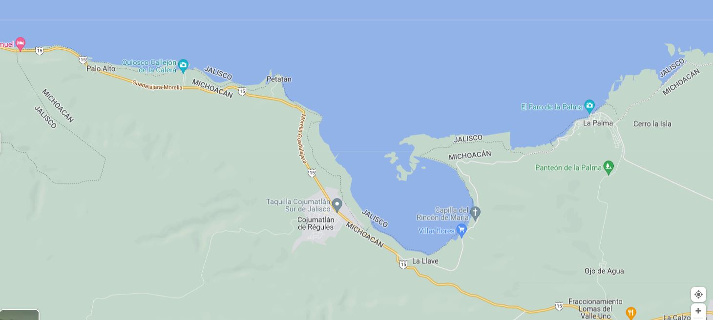
According to Google Maps, the entire southern shore of Lake Chapala belongs to Jalisco, not Michoacán . . .
– Según Google, toda la orilla sur del lago Chapala pertenece a Jalisco, no a Michoacán . . .

The south shore of Lake Chapala according to Google Maps (2022)

Google might want to alert Mexico’s mapping and statistics agency, INEGI, to that ‘fact.’

Google knows best? Not always!!

Population change in Jalisco, 2000-2010

 Maps  Comments Off on Population change in Jalisco, 2000-2010
Jan 242017
 

During the ten years between 2000 and 2010, Jalisco’s population increased by over a million from 6,322,002 to 7,350,355. Suburbs around Guadalajara dominated demographic change increasing by 887,301 (43.2%) to 2,940,118 (see Population change in the Guadalajara Metropolitan Area). The greatest growth was in the southern suburb of Tlajomulco which grew 237% from 123,619 to 416,552. Interestingly, the population of the central city of Guadalajara decreased by 152,185 to 1,494,134.

In this post, we look at the pattern of population change for the other municipalities in the state of Jalisco. The map shows the average annual percentage change in population for the period 2000-2010. It is worth noting that the population of a place with an annual growth rate of 3% will double in about 24 years.

Map of population change in Jalisco

Population change in Jalisco, 2000-2010. Copyright Tony Burton. Click image to enlarge.

What other areas of Jalisco are growing fastest?

Puerto Vallarta, the other major urban area in the state, grew by 38% to 255,725. The northern suburbs of Puerto Vallarta in the state of Nayarit grew even faster. The other major ex-pat area around Lake Chapala grew more slowly. Chapala grew by 12.4% to 48,812, Jocotepec by 18.0% to 42,142, while Poncitlan increased by 18.6% to 48,407.

Jalisco grew by 16.3% during the decade or an average increase of about 1.5% per year. But rates of population growth varied greatly from one area to another.

As indicated in the map, many of the isolated rural municipalities in the state actually declined in population (yellow-green and yellow areas). While births in these rural communities generally exceeded deaths, they experienced significant out migration.

In addition, many other rural communities in western Jalisco grew slowly at less than 1% per year (light pink on the map). Most of the communities in eastern Jalisco grew 1 – 2% about the same rate as the state as a whole.

Surprisingly, three of the most isolated municipalities in far northern Jalisco grew rapidly at over 3% per year. These municipalities are home to many indigenous Huichol Indians. Only relatively low numbers of Huichol Indians have migrated away from their ancestral homelands, so out-migration from these municipalities is much lower than from other remote parts of the state. In recent years, mining activity which was the mainstay of the economy of this area in colonial times, has made something of a comeback, thereby increasing local economic activity and opportunities.

Methodological note: The map depicts the municipal boundaries as they existed in the year 2000. Since that time, the municipality of Arandas has been split into two, reducing its territorial extent, and creating the new municipality of San Ignacio Cerro Gordo.

Is Jalisco the most “Mexican” state?

 Other  Comments Off on Is Jalisco the most “Mexican” state?
Jan 092017
 

Tapatíos (residents of Guadalajara) and Jaliscienses (residents of Jalisco) often brag that they live in the most “Mexican” area of the country. Are these boasts truthful? This is not an easy question to answer. It involves looking at a broad range of evidence.

Jalisco’s climate and natural ecosystems are very diverse like the country as a whole. It is the only state with all of the country’s five principal natural ecosystems (tropical evergreen forest, tropical deciduous and thorn forest, temperate forest, grassland and mesquite-grassland, and arid and semi-arid scrubland) [Geo-Mexico, page 31]. Furthermore, Jalisco has Lake Chapala, the country’s largest natural lake as well as the Colima Volcano, one of the most active in the country. Certainly from a physical geography perspective Jalisco appears the most representative of Mexico as a whole. (For other natural wonders of Jalisco see John Pint’s website: http://ranchopint.com).

Map of Jalisco state

Map of Jalisco. Copyright 2010 Tony Burton. All rights reserved.

Jalisco’s socio-economic characteristics are also representative of Mexico. Its population has an average growth rate and is distributed among a very large city, secondary and smaller cities, extensive farming communities and isolated indigenous areas. While its adjusted per person income is just below the national average, its human development index (composed of infant mortality rate, adult literacy, school enrollment ratio, and adjusted average personal income) is slightly above. Jalisco is similar to Mexico regarding the main economic sectors of agriculture, industry and services, including tourism.

From a tourism perspective, Jalisco includes everything Mexico has to offer: fantastic beach resorts, urban cultural and artistic attractions, natural wonders, significant indigenous areas and impressive archeological sites. On the other hand, Jalisco is not representative in that it is the leading agricultural state (first in production of corn, beef, pork, poultry, milk and eggs). It is also more predominantly Catholic and politically more conservative than Mexico as a whole. Aside from these two exceptions, Jalisco is quite representative from a socio-economic perspective.

Perhaps cultural aspects are the most important in determining the most “Mexican” of the 32 states. Here Jalisco really stands out. It is the birthplace of such stereotypical Mexican cultural characteristics as charrería (Mexican horsemanship), jarabe tapatío (Mexican hat dance), mariachi music, and tequila, the national drink.

In conclusion, the available evidence appears to support the boasts of some Tapatíos and Jaliscienses that they live in the “most Mexican” area of the country.

Many aspects of Mexico’s culture feature in Geo-Mexico: the geography and dynamics of modern Mexico, a handy reference guide to all aspects of Mexico’s geography. If you have enjoyed this post, consider gifting a copy of Geo-Mexico to someone you know.

Apr 282016
 

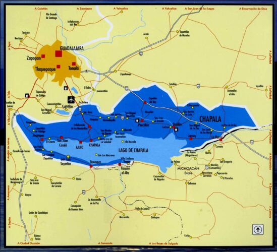
Like most geographers, I collect maps and information wherever I travel; you never know what surprises await. Tourism publications are especially interesting since they are specifically designed (one assumes) to show the best side of the places described.

My collection of tourist brochures associated with Jalisco and the Lake Chapala area dates back more than thirty years. Many early versions had stylized maps, drawn by graphic designers, not cartographers, with sound (if uninspiring) text in Spanish. English translations were often unintelligible. In the 1980s, several bilingual members of the now-defunct Association of Travel Reporters, based in Guadalajara, offered to help the Jalisco State Tourism Department improve its translations, but the offer was politely declined.

chapala-brochure-2016

As this latest brochure relating to Lake Chapala shows, translation standards have not improved significantly since then, and remain a long way off “native speaker” level. This is particularly unfortunate, given that this area of Mexico has the largest concentration of English-speakers in the country.

Here, for example, is the English translation of the attractions of San Juan Cosalá:

One has to closely experience San Juan Cosalá in order to feel and enjoy it to the most, so come and discover a place you will never want to leave, for every happy moment can be lived here, as just by visiting you feel enveloped in an affluent of joy and vitality.

In getting to know it, just stroll across its Pier, or admire the harmonious architecture in San Juan Evangelista Church, or enjoy the exquisite aromas of seafood, bouncing from restaurants enlivened with fine music while walking over the Piedra Barrenada (Drilled Stone); or the rest;  freshness and fun offered in thermal waterparks and world level spas.

Undated tourism brochure, collected April 2016

Undated tourism brochure, collected April 2016

The cartography (above) also leaves a lot to be desired. A key (not shown in this post) is provided but the Jalisco Tourism department clearly needs to hire a geographer if they want to publish useful and meaningful maps. Details worth noting include:

  • No symbol in the key for the “gas station” signs shown on the map. The map shows only four gas stations in this area (and none in Chapala or Ajijic); there are dozens of others not shown on the map, including several in Chapala and Ajijic.
  • The map has no scale.
  • The Isla de los Alacranes, a short boat-ride from Chapala, is shown a long way south of its true position, and a lot further from Chapala than it really is.
  • The dark blue area is, according to the key, the Chapala Lakeshore. I have absolutely no idea what it really represents! Lake Chapala’s catchment area is a completely different shape to the dark blue area. The “Chapala Lakeshore” should, obviously, also include the south-east section of the lake around Las Palmas and Cojumatlán. Much of the area colored dark blue is out of view of the lake, and drains towards the Santiago River, not the lake.
  • Placing the word “CHAPALA” in the north-east section of the dark blue area is totally misleading. The area where the word is written is NOT in the lake basin, not in view of the lake, and is not even in the municipality of Chapala. Again, I have no idea why the artist responsible for this map chose to ignore geography.

It is 2016, and Jalisco State tourism officials still need to improve the quality of their brochures and maps. Come on guys! Time to up your game!

Jul 092015
 

The Jalisco state government has released an informative 5-minute video highlighting some of the reasons why Jalisco is one of the best locations in Mexico for farming, business and tourism.

The video can be viewed on Facebook: Esto es Jalisco. This is Jalisco.

Following opening shots showing some of the diverse landscapes of the state, including the Piedrotas at Tapalpa, the majestic Volcán de Colima (whose summit is actually in Jalisco, not Colima) and the Horseshoe Falls near the Dr. Atl park on the northern edge of Guadalajara, the video’s subtitles (in English) turn to techno0logy and innovation. Jalisco is the first state in Mexico to have a Ministry of Innovation, Science and Technology. The state capitol Guadalajara is the center for MIND (Mexican Innovation and Design Center) and was chosen by MIT for the establishment of a Creative Digital City.

Map of Jalisco state

Map of Jalisco. Copyright 2010 Tony Burton. All rights reserved.

The city also has major cultural and sporting attractions, from libraries to golf courses to hosting international events in the Expo Guadalajara to concerts and its own international film festival. It also hosts the world’s second largest book fair (after Hamburg). Its industrial activity ranges from agro-processing (including tequila) to pharmaceuticals, information technology, automotive and aerospace firms to renewable energy enterprises.

Foreign investment in Jalisco has risen by an average of 17% a year for the past decade, with foreign firms finding the state’s geographic position advantageous for serving central Mexico and with excellent trade links to Asia and the U.S.

The state’s leading coastal resort is Puerto Vallarta, but tourism is also important in the state’s interior. Jalisco has five places with Magic Town status: Lagos de Moreno, San  Sebastian del Oeste, Tapalpa, Mazamitla and Tequila.

Jalisco currently accounts for 6.6% of national GDP and the state government clearly expects this contribution to grow in coming years. This professionally-produced video is an excellent visual introduction to one of Mexico’s most important states.

Related posts:

Retirees and “residential tourism”: a case study of Chapala-Ajijic in Jalisco

 Excerpts from Geo-Mexico  Comments Off on Retirees and “residential tourism”: a case study of Chapala-Ajijic in Jalisco
Jan 162014
 

Retirees, mainly from the USA and Canada, form a special subgroup of tourists. About 1 million US visitors to Mexico each year are over the age of 60. Their total expenditure is about $500 million a year. Three-quarters arrive by air; half of these stay 4-8 days and almost one in ten stays 30 days or longer. Half stay in hotels, and one-third in time-shares; the remainder either stay with family or friends, or own their own second home. Of the 25% arriving by land, almost one in three stays 30 days or more. For Canadians, the patterns are broadly similar except that a higher percentage arrive by air.

The number of retiree tourists is relatively easy to quantify. However, it is extremely difficult to place accurate figures on the number of non-working, non-Mexicans who have chosen to relocate full-time to Mexico. Technically, these “residential tourists” are not really tourists at all but longer-term migrants holding residency visas. They form a very distinct group in several Mexican towns and cities, with lifestyle needs and spending patterns that are very different from those of tourists. Their additional economic impact is believed to exceed $500 million a year.

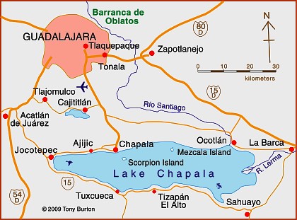
Map of Lake Chapala, Jalisco, Mexico

Map of Lake Chapala, Jalisco, Mexico. Credit: Tony Burton; all rights reserved.

The largest single US retirement community outside the USA is the Guadalajara-Chapala region in Jalisco, according to state officials (see map). The metropolitan area of Guadalajara, Mexico’s second city, has a population of about 4 million. The villages of Chapala and Ajijic (combined population about 40,000) sit on the north shore of Lake Chapala some 50 km (30 mi) to the south. Historically, Chapala was the first lakeshore settlement to attract foreign settlers, as early as the start of the 20th century. Today the area is home to a mix of foreign artists, intellectuals, escapees (of various non-judicial kinds), pensioners and ex-servicemen. In the last 40 years, Ajijic has become the focal point of the sizable non-Mexican community living on the lakeshore. Depending on how they are defined, there are probably between 6000 and 10,000 foreign residents in the Chapala-Ajijic area, the higher number reflecting the peak winter season. About 60% of retirees in the area own their own homes or condos, though many still own property in the USA or Canada as well, and many make regular trips north of the border.

The main pull factors for residential tourists are an amenable climate; reasonable property prices; access to stores, restaurants and high quality medical service; an attractive natural environment; a diversity of social activities; proximity to airports; tax advantages, and relatively inexpensive living costs.

David Truly has suggested that conventional tourist typologies do not work well with Ajijic retirees. He identified migrant clusters with similar likes and dislikes. Retirees vary in education, travel experience and how they make decisions about relocation. Early migrants tended to dislike the USA and Canada and adapted to life in Mexico. They were generally content with anonymity unlike many more recent migrants. Traditional migrants appreciate all three countries, but have chosen Mexico as their place of permanent residence. Many new migrants do not especially like the USA or Canada but are not particularly interested in Mexico either. They seek familiar pastimes and social settings and are content to have relatively little interaction with Mexicans.

The large influx of residential tourists into small lakeside communities like Ajijic inevitably generates a range of reactions among the local populace. From empirical studies of regular tourism elsewhere, George Doxey developed an “irritation index” describing how the attitudes of host communities change as tourist numbers increase. His model applies equally well to residential tourists. In the initial stage the host community experiences euphoria (all visitors are welcome, no special planning occurs). As numbers increase, host attitudes change to apathy (visitors are taken for granted) and then annoyance (misgivings about tourism are expressed, carrying capacities are exceeded, additional infrastructure is planned). If numbers continue to grow, hosts may reach the stage of antagonism, where irritations are openly expressed and incomers are perceived as the cause of significant problems.

Residential tourism in the Chapala-Ajijic area has certainly wrought great changes on the landscape. Residential tourists have created a distinct cultural landscape in terms of architectural styles, street architecture and the functions of settlements. (Browse the Chapala Multiple Listing Service New Properties). Gated communities have been tacked on to the original villages. Subdivisions, two around golf courses, have sprawled up the hillsides. Swimming pools are common. Much of the signage is in English. Even the central plazas have been remodeled to reflect foreign tastes. Traditional village homes have been gentrified, some in an alien “New Mexico” style.

On the plus side, many retirees, as a substitute for the family they left behind, engage in philanthropic activities, with a particular focus on children and the elderly. Retiree expenditures also boost the local economy. Areas benefiting from retirees include medical, legal and personal services, real estate, supermarkets, restaurants, gardening and housecleaning. Employment is boosted, both directly and indirectly, which improves average local living standards.

On the minus side, decades of land speculation have had a dramatic impact on local society. Land and property prices have risen dramatically. Many local people have become landless domestic servants, gardeners and shop-keepers with a sense that the area is no longer theirs. Crime levels have risen and some local traditions have suffered. The abuse of water supplies has resulted in declining well levels. Over zealous applications of fertilizers and pesticides have contaminated local water sources.

Other locations besides Chapala-Ajijic where a similar influence of non-Mexican retirees on the landscape can be observed include San Miguel de Allende (Guanajuato), Cuernavaca (Morelos), Mazatlán (Sinaloa), Puerto Peñasco (Sonara), Rosarito (Baja California) and Todos Santos (Baja California Sur). The most preferred locations are all on the Pacific coast side of Mexico.

As more baby-boomers reach retirement age, residential tourism offers many Mexican towns and cities a way of overcoming the seasonality of conventional tourism. Lesser-developed regions have an opportunity to cash in on their cultural and natural heritage and improve their basic infrastructure.

This is a lightly edited excerpt from chapter 19 of Geo-Mexico: the geography and dynamics of modern Mexico.

References:

  • Boehm S., B. 2001 El Lago de Chapala: su Ribera Norte. Un ensayo de lectura del paisaje cultural. 2001. Relaciones 85, Invierno, 2001. Vol XXII: 58-83.
  • Burton, T. 2008 Lake Chapala Through the Ages, an Anthology of Travellers’ Tales. Canada: Sombrero Books.
  • Doxey G.V. 1975 A causation theory of visitor‑resident irritants: methodology and research inferences. Proceedings of the Travel Research Association, San Diego, California, USA: 195‑8.
  • Stokes, E.M. 1981 La Colonia Extranero: An American retirement Community in Ajijic, Mexico. PhD dissertation, University of New York, Stony Brook, cited in Truly, D. 2002.
  • Truly, D. 2002 International Retirement migration and tourism along the Lake Chapala Riviera: developing a matrix of retirement migration behavior. Tourism Geographies. Vol 4 # 3, 2002: 261-281.
  • Truly, D. 2006 The Lake Chapala Riviera: The evolution of a not so American foreign community, in Bloom, N.D. (ed) 2006 Adventures into Mexico: American Tourism beyond the Border. Rowman & Littlefield: 167-190

Related posts:

Nov 142013
 

About 160 kilometers (100 miles) north of Guadalajara as the crow flies is a wild and inhospitable arm of the Western Sierra Madre called the Sierra of Bolaños, a rugged northern extension of Jalisco most easily reached by light aircraft. The one way trip by road requires driving more than 320 kilometers (200 miles) from Guadalajara, half the distance being inside the adjacent state of Zacatecas. The Bolaños region has for centuries been an important silver mining area, and British capital and engineers left an indelible mark on the towns there.

Bolaños, the setting.

Bolaños, the setting. Credit: Tony Burton; all rights reserved

The once-grand colonial mining town of Bolaños fits snugly between the river and the rocky cliffs into which the first mine shafts were sunk. Its numerous old stone buildings, often with ornately carved doorways and windows, make it a fascinating place to wander around. With judicious restoration, Bolaños could undoubtedly find its way onto anyone’s list of Mexico’s top mining towns to visit. The town’s hanging bridge (puente colgante) links Bolaños, on the edge of mestizo territory, with the Huichol Indian villages in the mountains on the far side of the river. Huichol artwork, including colorful beadwork, is on sale in several stores in the town and it is common to see traditionally-dressed Huichol Indians in the streets.
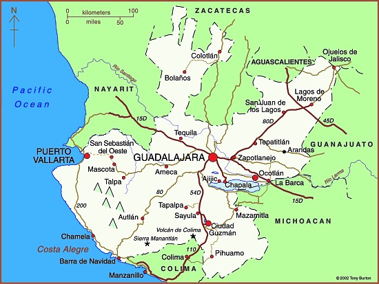
Map of Jalisco state

Map of Jalisco. Copyright 2010 Tony Burton. All rights reserved.

Mineral riches

Relatively little is known of the pre-Columbian history of the Sierra of Bolaños but the area was probably only sparsely peopled, perhaps by Tepecano Indians. By the beginning of the seventeenth century, Spanish adventurers had founded the town of Chimaltitán which later served as their base for both subduing the natives militarily and converting them to Christianity. They later founded the towns of Bolaños, a short distance to the north, and San Martín de Bolaños to the south.

By the mid-eighteenth century, the Spanish were in complete control and the Bolaños mines were producing between 2 and 3 million pesos worth of silver per year, or about 25% of the silver production in the whole of New Spain—a very considerable amount, bearing in mind that each peso was then worth about a dollar.

By the 1760s, 16,000 people lived here. Overlooking an attractive small park in Bolaños is the rococo Guadalupe Chapel (the church of San José), a gift to the town from Antonio de Vivanco, owner of several mines. In 1789, de Vivanco became Marquis Vivanco, Viscount of Bolaños.The prosperity of these times is reflected in the sumptuous architecture of the buildings in Bolaños that date from this period. Two particularly fine examples are the Casa de la Condesa, and Antonio de Vivanco’s former home, with its unusual frescoes, both on the street which parallels the river. Bolaños even boasted a two-story Royal Mint, with a lovely facade. Built on one side of the main plaza in the 1750s, this partially restored gem has an Austrian Hapsburg two-headed eagle carved in the stone above its main door. This royal crest may have inspired the local Huichol Indians to use two and even four-headed eagles (a head for each cardinal direction) in their handicrafts.
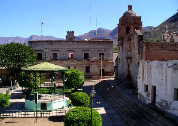
Main plaza in Bolaños

Main plaza in Bolaños. Photo: Tony Burton; all rights reserved

But the boom times of the 1750s were not to last for ever. Following a series of floods (the most serious of which occurred in 1757 and 1781), land disputes, the ever-increasing quantities of costly mercury required for smelting, and disagreements over mining rights, Bolaños’s first boom period came to an abrupt end. By 1798 the town was virtually abandoned. Its largest church, begun in 1778, still stands half-finished; today, this is probably the only place in the world where you can play basketball under floodlights in the shell of an ancient church!

A new company and British miners

British influence in Mexico quickly gained momentum following Mexico’s Independence in 1821. On 27 September 1821, Agustín de Iturbide entered Mexico City in triumph. Most gachupines (Spanish-born residents of Mexico) had fled with whatever assets they could muster back to Spain. The rest were expelled in 1829. Iturbide desperately needed funds, to pay his 80,000-strong army and to set up an administration but, after eleven years of war and chaotic politics, the nation was fatigued and the Treasury empty.

In order to stimulate the Mexican economy, Iturbide needed to revive the mines, many of which had been abandoned during the Independence War. However, the mines had drainage problems and needed large investments of capital. Mexico’s need, coupled with the aspirations and greed of England’s capitalists, proved to be an unstoppable combination. Between 1820 and 1824, no fewer than seven different mining corporations relying on U.K. capital were formed in Mexico. One of these was the Venture Company of the Mines of Bolaños.

The Bolaños Company commissioned a full inspection of their mines. This concluded that, given “modern technology”, a fortune in silver was awaiting exploration, with a potential profit of over a million dollars. The firm’s investors were happy to pour money into bringing British machinery and the ingenuity of expert tin miners from Cornwall to back up their intentions.

In the early days, it was difficult and even dangerous to travel to the mines. No fewer than 15 of the 45 Cornish miners who accompanied the first shipment of machinery for Bolaños in 1825, died through accidents or disease before taking up their posts.

Mine owners had their own agenda. Most insisted that their miners worked completely naked in an effort to thwart any attempted pilfering of ore. Miners grew ever more ingenious in trying to circumvent the rules. They were discovered concealing silver ore in their hair, hollowed-out hammer handles, their mouths and ears, and even, on one occasion, inside the disemboweled body of an overseer killed in an accident!

Despite all the problems the British were determined to succeed. They built a reservoir above the village of Tepec and then a five kilometer long canal, much of it underground, to bring water to the town of Bolaños. On the east side of the small church in Tepec, a camposanto (cemetery) was built specifically for the English miners and their descendants since they were not Catholics and should not therefore be buried in the town’s main graveyard.

To assist in drainage, the British assembled two massive hydraulic wheels, one 12 meters, and the other 14 meters in diameter. Their most important contribution, though, was to import a 32-ton steam engine from the U.K. It took 106 days for this engine to be hauled over the mountains from Veracruz. Locals say that the reason the San José church now has only small bells is because the large ones were melted down to make wheel rims to help move the steam engine.

Bolaños grew into a town of more than 30,000 people, with seven major mines in production, employing thousands of workers. However, despite the mammoth injection of British capital and technology, the company failed to extract enough silver to obtain any return on its investment. In 1842, amidst political rumblings after several accidents and a fire which cost the lives of more than 150 miners, and with the Mexican government delaying payments for silver bars “bought” by the Mint, the company was wound up and Bolaños once again echoed to the sounds of bird-song rather than of hammer, chisel and steam engine.

The town’s population declined to fewer than 5000. It became a ghost town, another casualty of the ever-changing fortunes of mining centers around the world. Various attempts to revive the mines in the late nineteenth century by North American interests came to nothing. At the end of the last century, a U.S.-Mexico joint venture mined successfully for some years but finally went out of production in about 1998. Today, Bolaños is still a small town, a mere shadow of its former self, though one offering a few small hotels and ample opportunities for adventure, eco- and cultural tourism.

Twenty kilometers south of Bolaños, down the valley and past Chimaltitán, is San Martín de Bolaños. The El Pilón mine, near San Martín, opened in the 1980s, is the only mine currently operating in the valley. By 2007, it had produced over 30 million ounces of silver, as well as some ancillary gold.

A visit to this remote corner of Jalisco provokes deep feelings of admiration for the courage and audacity of all those who chose to settle here, including the nineteenth century British immigrants who left a Europe torn by upheaval, in search of fame and fortune in Mexico.

This is a lightly edited excerpt from chapter 23 of my Western Mexico: A Traveler’s Treasury (4th edition, 2013)

Other posts related to Bolaños:
Case study of the June 2013 ecocide in Hurtado Reservoir, Jalisco

 Mexico's geography in the Press  Comments Off on Case study of the June 2013 ecocide in Hurtado Reservoir, Jalisco
Jul 042013
 

This post presents a short case study of the dramatic ecocide in the Hurtado Reservoir in Jalisco a week ago that resulted in the sudden death of between 200 and 500 tons of fish.

What?

  • The ecocide killed between 200 and 500 tons of fish
  • 30 local residents were affected by gastrointestinal problems
  • 15 of them required treatment in local health centers

Where?

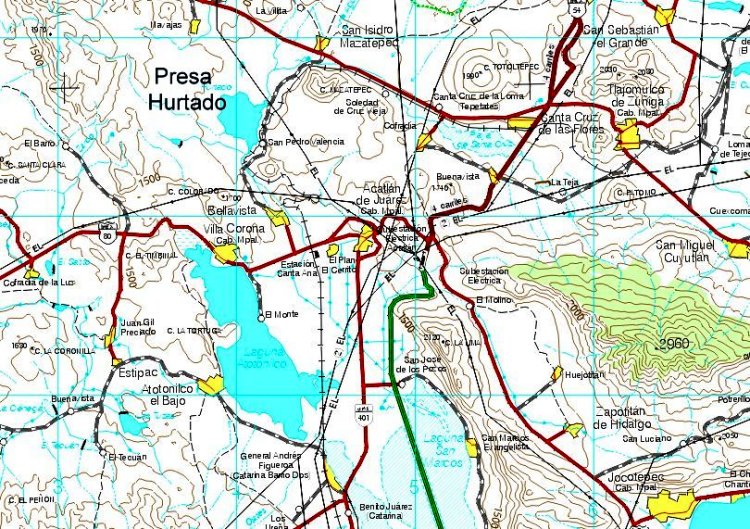
The ecocide occurred in the Hurtado Reservoir (Presa del Hurtado, aka the Valencia Dam) in Jalisco, mid-way between the villages of San Isidro Mazatepec and Bellavista, the location of a sugarcane mill (see map). The reservoir can hold up to 8,000,000 cubic meters of water. The two municipalities involved are Acatlán de Juárez and Tlajomulco de Zúñiga. The most affected community is the small village of San Pedro Valencia (about 300 inhabitants),

Location of Hurtado Reservoir (extract from INEGI 1:250,000 map)

Location of Hurtado Reservoir (extract from INEGI 1:250,000 map)

When?

The first reports were made on 25 June when a local government official in San Pedro de Valencia, in the municipality of Acatlán de Juárez, reported to state environmental protection officials that the water in the Hurtado Reservoir was contaminated with something smelling like molasses. Within 48 hours, officials had identified the source, and had conducted a formal inspection, reporting that the water was dark brown in color and contaminated with molasses.

Why?

According to press reports, an unlicensed firm in nearby Potrero los Charros was using molasses (a by-product of sugarcane mills) as an ingredient to make cattle food. Some of the molasses (melaza) was dumped into the San Antonio stream which carried them into the reservoir.

The problem arose because molasses have a very high biochemical oxygen demand (BOD). This means that they require large amounts of oxygen as they decompose. In this case, they required more oxygen than was available in the water in the reservoir, reducing the water’s dissolved oxygen content, effectively depriving all aquatic life of oxygen. While final results are pending, the fish are believed to have died of oxygen starvation.

Effects

  1. The local fishing cooperative of the Hurtado Reservoir has agreed to accept a moratorium on catching, selling or consuming local fish. The fishermen normally catch and market about 100 kg of fish a day.
  2. Health services are offering vaccinations to local residents and all those involved in the environmental clean-up.
  3. 18 local restaurants are closed until further notice. When they reopen, they will likely have to purchase fish from further away (eg the fish market in Guadalajara) at a higher price than they previously paid for local fish
  4. About 100 fish traders in nearby towns (including Tala, Acatlán de Juárez and Villa Corona) have lost a source of income.

Responses

  1. Within 48 hours of the first report, authorities had ordered the business responsible for the pollution to take immediate remedial action. Meanwhile, authorities began to clean up the dead fish. The fish are being buried in a 30 meter by 2 meter trench about one km away from the lake.
  2. Federal officials from the National Water Commission and the Environmental Secretariat were quickly on the scene; they promised access to federal financial assistance.
  3. Most of the clean up was carried out by about 100 local fishermen and volunteers, including firefighters.
  4. State health officials have closed the 18 small fish restaurants near the lake until further notice
  5. Local officials are also cleaning up the storage area, using tanker trucks to remove an additional 8,000 tons of molasses for appropriate disposal elsewhere.
  6. The municipality of Tlajomulco has issued the owner of the company with a fine of about 1.5 million pesos ($120,000) and further legal action is underway.

Remediation

  • Environmental expert Gualberto Limón Macías estimates it will take between two and four years to rehabilitate the reservoir. The priority is to re-oxygenate the water, possibly using solar-powered pumps, and seed the reservoir with young fish.
  • The University of Guadalajara has promised to arrange for a team of experts to provide specialist advice about how best to rehabilitate the lake.

Related posts:

What are the 10 main pressures threatening the Primavera Forest in Jalisco?

 Other  Comments Off on What are the 10 main pressures threatening the Primavera Forest in Jalisco?
Jun 222013
 

A 1988 Management plan for the Primavera Forest (Plan de Manejo Bosque La Primavera), published by the University of Guadalajara, included a detailed list of the then-existing pressures on the forest.

Sadly, not much has changed since then, and almost all the sources of pressure mentioned in that study still apply today.

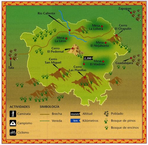
The Primavera Forest. Credit: Semarnat, 2003

The Primavera Forest. Credit: Semarnat, 2003

The management plan argues that the key areas (see map) where careful management is essential include:

  • Cerro San Miguel and Cerro Las Planillas, the highest elevations in the area
  • The environs of the tourist spa of Río Caliente (this spa is now closed)
  • Mesa de Nejahuete, in the center of the volcanic caldera, and
  • Mesa del León, considered an important habitat, primarily for fauna

The plan identifies the following sources of concern (note that this list is in no particular order, and certainly not in order of highest pressure to lowest):

1. Tourism. Poorly planned recreation areas, such as autodromes and spas. Issues resulting from this source of concern include pollution, waste disposal, soil erosion, landscape degradation, habitat change, reduced fauna and, switching to a human focus, delinquency. Motorcycles and trail bikes are a particular problem because of the associated noise pollution, annoyance and risk to other visitors, habitat destruction, the displacement of fauna and often lead to accelerated soil erosion.

2. Ejidos. Any expansion of neighboring ejidos means more homes, deforestation and landscape alteration.

3. Quarrying. The quarrying of local rocks such as pumice or river deposits, as well as a number of abandoned quarries can result in habitat destruction, erosion, forest degradation, accelerated mass movements (landslides, rockfalls), posing a risk to infrastructure, access routes and the potential pollution of ground water.

4. Hunting. Hunters leave spent cartridges that can pollute the soil, as well as wounded and abandoned animals. Larger fauna have become progressively more scarce. In addition, the presence of individuals carrying firearms poses a security threat.

5. Cultivation and Overgrazing. Increased cultivation (primarily for sugar cane, corn and beans) has gradually nibbled away at the edges of the forest, with the clearance method of slash and burn being a particular problem since it greatly raises the risk of wildfires, soil degradation and deforestation. As the number of access routes increases, it is easier for local farmers to graze livestock in the forest, reducing the health of the  grassland, and leading to a relative abundance of unwanted plants and weeds, accelerated soil erosion and the possible contamination of water sources.

6. Deforestation. Deforestation is also a pressure on the forest, in which the cutting of woodland for fuel (including bonfires) and for firebreaks, leads to changes in habitat and soil use, with the secondary effects of increased erosion, reduced ground water recharge and varying degrees of secondary forest succession.

7. Geothermal Power. The potential development of some areas for geothermal power by the Federal Electricity Commission (CFE) has already involved the opening of access routes and would lead to noise contamination (with adverse effects on fauna) and possible pollution of ground water, air and soil, as well as deforested hillsides. The loss of vegetation cover would trigger accelerated erosion, and habitat destruction, further reducing water quality. Access routes attract other “users” such as those seeking to quarry local rocks or clear land for farming.

8. Settlements. Settlements and subdivisions have also encroached on the forest. Some are irregular/illegal settlements, but others are private homes and clubs. Regardless of economic level, these settlements result in a decrease in vegetation and the elimination of the soil’s litter layer, leading to soil compaction, lowered infiltration rates, and nutrient-depleted soils, as well as increased pollution and the gradual elimination of native fauna

9 Wildfires. Wildfires, such as that in 2012, destroy vegetation and cause a general degradation of the woodland. They can result in the accelerated degradation of soil, water and vegetation, leading to significant changes to soil structure, as well as increased runoff and reduced groundwater recharge.

10. Inadequate regulations. The problems faced by the Primavera Forest are compounded because the relevant local authorities have shown little interest in ensuring adequate regulations, supervision and enforcement.

Many of these ten major pressures are closely interrelated. Despite the good intentions back in 1988, it is clear now, with the benefit of hindsight, that the 1988 management plan did not achieve very much. Hopefully, in the not too distant future, and as the Primavera Forest gains international status as a possible Geo-Park, a more comprehensive and effective management plan can be devised and implemented.

Related posts

How was the Primavera Forest caldera in Jalisco formed?

 Other  Comments Off on How was the Primavera Forest caldera in Jalisco formed?
Jun 102013
 

In a previous post, we described the considerable geotourism potential of the Primavera Forest near Guadalajara:

In this post, we take a closer look at how this unusual area was formed.

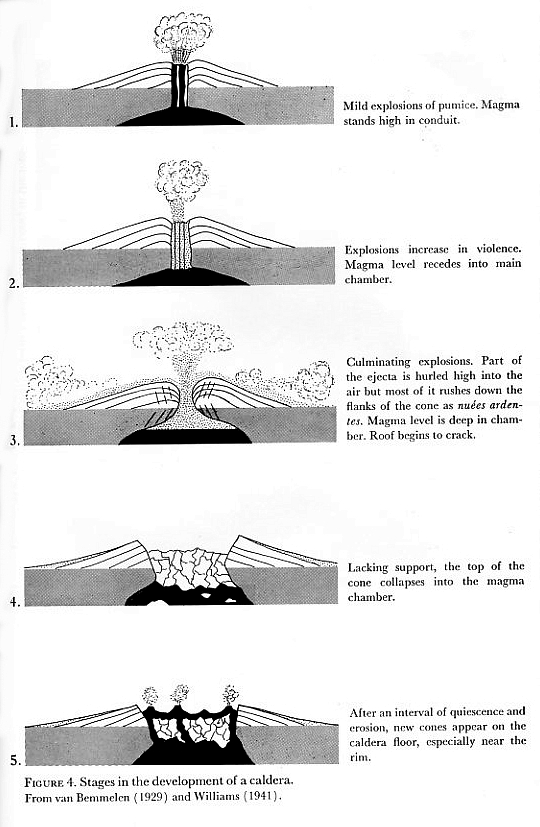
Stages 1 and 2 (see diagram):

140,000 BP. The magma chamber beneath the surface began to fill with magma (molten rock underground) and grow in size.

By about 120,000 BP, several lava flows and domes had formed, made primarily of rhyolite, a silica-rich (“acid”) igneous rock. After each eruption, the magma level underground would subside for a period of time before pressure built up again towards the next eruption.

Formation of a caldera

Fig. 4 of Bullard (1962) “Volcanoes in history, in theory, in eruption”. Based on van Bemmelen (1929) and Williams (1941)

Stages 3 and 4

So much pressure had built up by about 95,000 BP that there was a huge explosion, sending 20 cubic kilometers (4.8 cubic miles) of rock and ashes high into the sky. The explosion covered 700 square kilometers (270 square miles) with volcanic materials, known today as the Tala tuff (tuff is the geological term for consolidated ash). This massive explosion caused the upper part of the magma chamber to collapse, leaving a caldera that was 11 kilometers (6.8 miles) wide. The Tala tuff includes large quantities of pumice, a light and porous volcanic rock formed when a gas-rich froth of glassy lava solidifies rapidly.

This caldera filled with water, creating a lake.

Stage 5

This stage began shortly afterwards when a series of ring domes were erupted around the edge of the caldera as the magma deep below the surface started to push upwards again, eventually forming small islands in the lake. These eruptions formed more pumice, blocks of which would break off and start to float across the lake as they gradually sank to the lake floor.

A further series of eruptions in about 75,000 BP led to a second series of ring domes. A combination of tectonic uplift and sedimentation had filled the lake in by about this time.

More volcanic domes have been created at approximately 30,000 year intervals since, in about 60,000 BP and about 30,000 BP; these domes were almost all on the southern and eastern margins of the caldera, and include the lava domes of El Colli and El Tajo on the outskirts of Guadalajara.

Many geologists appear quietly confident that lava and ash eruptions in La Primavera are a thing of the past. They consider that the Primavera Forest’s fumaroles, hot river and hot waterfall represent the last vestiges of vulcanism and are no cause for alarm. On the other hand, others, including Gail Mahood who has studied this area far more than most, warn that hazard monitoring is justified in the case of La Primavera given its proximity to a major city and bearing in mind that any future eruption would be likely to occur on the southern and/or eastern side of the caldera.

The La Primavera Forest is only one of several calderas in Mexico’s Volcanic Axis.

If you prefer a short 9 minute video animation of how the area was formed, try this excellent YouTube video: “The Exciting Geology of Bosque La Primavera“, produced by geologist Barbara Dye during her stint as a Peace Corps volunteer in Mexico.

References:

  • Mahood G. A. 1980. Geological evolution of a Pleistocene rhyolitic center – Sierra La Primavera, Jalisco, Mexico. Journal of Volcanology and Geothermal Research, 8: 199-230.
  • Mahood, G.A. 1981. A summary of the geology and petrology of the Sierra La Primavera, Jalisco, Mexico. Journal of Geophysical Research, Volume 86.
  • Dye, Barbara. 2013. “La Apasionante Geología del Área de Protección de Flora y Fauna La Primavera”.

Related posts:


Mexico’s geomorphosites: the Primavera Forest, Guadalajara, Jalisco

 Other  Comments Off on Mexico’s geomorphosites: the Primavera Forest, Guadalajara, Jalisco
Jun 012013
 

The Primavera Forest (aka Bosque de la Primavera, Sierra de la Primavera) is a volcanic region located immediately west of Mexico’s second-largest city, Guadalajara. The Primavera Forest occupies an ancient volcanic caldera, where the last eruptions are thought to have been about 30,000 years ago. The Primavera is a wilderness area of pine and oak woodland, with hot-water rivers, nature-trails and thermal spas. The park, which is about 30 km (19 mi) across (see map), serves as the lungs of Guadalajara and is popular, especially on weekends, for activities such as picnics, birdwatching, hiking, climbing, mountain biking and motocross.

The Primavera Forest. Credit: Semarnat, 2003

Basic map of the Primavera Forest. The distance between Tala and Guadalajara is about 35 km (22 miles). Credit: Semarnat, 2003

The main geographic and geological attractions of the Primavera Forest include:

Scenery, views, flora and fauna

The average elevation of the Primavera Forest is about 2200 m above sea level, rising to 2270 m (7447 ft) towards the eastern edge of the forest which overlooks the city of Guadalajara. The three main summits are El Pedernal, San Miguel and Las Planillas. There is easy access to the 30,000 ha of protected natural area from various points, including the town of Tala and from Highway 15 (the main Guadalajara-Tepic highway) which skirts the northern edge of the Primavera. Agriculture and settlement have made incursions into the edges of the park, with land cleared for subdivisions or for fields of sugarcane and agave (for tequila). A major wildfire raged through parts of the forest in 2012.

The park is home to about 1000 different plant species as well as 137 different birds and at least 106 terrestrial animals, including deer, puma, opossums (tlacuaches), armadillos and rabbits.

Hot springs

Thermal springs are common throughout the Volcanic Axis of Mexico, and the hot river and many hot springs in the Primavera Forest are a legacy of its volcanic history. Río Caliente, the main developed spa in the Primavera Forest, famous for several decades as one of the country’s top vegetarian and health spas, closed in 2011, following some years of uncertainty regarding its land tenure status and increasing security concerns because of its relatively remote location.

The hot springs in the park have been subject to numerous exploratory studies by the Federal Electricity Commission (CFE) which considers the park a potential source of geothermal power. The CFE drilled a dozen wells in the 1980s, finding that six of them offered sufficient flow for power production. The CFE believes the park could support at least three 25 megawatt geothermal plants. Drilling was suspended between 1989 and 1994 when the Jalisco state government ordered the CFE to carry out environmental restoration to areas damaged by drilling activities, and the plants have not yet been approved.

Pumice deposits

As veteran explorer-author John Pint points out in “A geopark in my back yard?”, the Primavera Forest is well known to geologists for its giant blocks of pumice, up to several meters across, which are among the largest found anywhere in the world. One of the best locations for seeing these is in the 50-meter-high walls of the Río Seco arroyo on the northern edge of the park, on the outskirts of the small community of Pinar de la Venta. The cliff face has a thick band of pumice overlying numerous thin layers of lake sediments. The pumice blocks are highly vesicular (full of holes) and therefore surprisingly light for their size.

Obsidian deposits

The Primavera Forest is also well known to geologists (and archaeologists) because it has significant amounts of obsidian, a hard, glassy, usually black rock. Obsidian is easy to find (often in big chunks) in several parts of the park. The obsidian formed when blocks of hot lava, still molten, rained into the cold waters of a lake, cooling instantaneously. When fractured, pieces of obsidian acquire very, very sharp edges. Even today, some surgeons still prefer obsidian scalpel blades, recognizing that they are far sharper than those made from even the best steel.

Obsidian was in great demand in precolonial times for use as mirrors, arrowheads and knives, as well as jewelry:

“Among the people to prize obsidian were the residents of Iztépete (often spelt Ixtépete), “hill of obsidian or knife blades”, located just outside the eastern edge of La Primavera. This small, largely forgotten, and poorly-signed archaeological site in a southern suburb of Guadalajara is within a stone’s throw of the city’s periférico (ring-road).”

“Large, angular chunks of obsidian litter the slopes of Cerro Colli, the hill rising behind the 6-meter-high pyramid, which conceals at least five earlier pyramids, each superimposed over the one before. Ceramics found here suggest that occupation stretches back at least to the fifth century, but little is known about the people who built this site.”  [Quotes are from the recently published 4th edition of the author’s “Western Mexico, A Traveler’s Treasury”]

Obsidian is found throughout this region, and while usually black in color, it can also be found in a range of hues, including red and even rainbow patterns. Not far from the western edge of Primavera, at the foot of a steep-sided knoll called El Picacho is El Pedernal, reputed to be the largest obsidian deposit in the world, covering 4 square kilometers, from which an astonishing 40,000 cubic meters of rock have been extracted over the centuries. Sophisticated chemical techniques have shown that El Pedernal obsidian was widely used in Mesoamerica, finding its way as far north as California and as far south as Oaxaca!

The pre-Columbian obsidian jewelry from this region, consisting of very thin wafers of rock, is unique to this area, and clearly the work of highly skilled specialist craftsmen. One particularly fine example (now in the museum in Tala) is a necklace fashioned out of wafer-thin obsidian carvings of human figures, each pierced by a tiny hole. In the absence of metal tools, the patience and dexterity required to have made these is truly amazing.

The art of obsidian carving has not been lost. Skilled artisans in Navajas, another nearby village, continue to this day to chip and shape chunks of obsidian into spheres, chess boards and beautiful works of art, often representing animals.

In future posts we will consider the formation of the La Primavera Forest in more detail, and also look at the extent to which the pressures resulting from its proximity to the city of Guadalajara threaten the park’s long-term health.

Want to read more?

John Pint is one of those spearheading the proposal of seeking UNESCO designation for La Primavera as a GeoPark.

U.S. Peace Corps Volunteer and geologist Barbara Dye has written a beautifully-illustrated  72-page guide (in Spanish) to the geology of the Primavera Forest: “La Apasionante Geología del Área de Protección de Flora y Fauna La Primavera”.

Related posts:

Magic Town #66: Lagos de Moreno, “the Athens of Jalisco”

 Mexico's geography in the Press  Comments Off on Magic Town #66: Lagos de Moreno, “the Athens of Jalisco”
Nov 242012
 

Lagos de Moreno, just designated Mexico’s Magic Town #66, is a town with a charming ambiance. A succession of small squares with old trees and gardens, connected by shaded streets, gives it a cultured university air. At every turn there are beautifully kept old buildings to be enjoyed and it is absolutely fitting that the town, in its entirety, should have been declared a national monument.

Lagos de Moreno is Jalisco’s fifth Magic Town. Boasting more than 380 cultural and historic sites, its peak coincided with the governments of President Porfirio Díaz in the late 1800s when local haciendas produced both an aristocratic elite and plenty of money enabling them to enjoy what they considered were the better things in life.

La Rinconada restaurant, Lagos de Moreno

La Rinconada restaurant, Lagos de Moreno. Credit: Mark Eager / Sombrero Books

Lagos was founded as Santa María de los Lagos in 1563 on the west bank of the broad Lagos River. It assumed its modern name in 1827. In early colonial times, its inhabitants had to withstand repeated attacks from the Chichimecas. When silver was discovered in large quantities near Zacatecas, further north, the town became a natural staging-post on the mule route to Mexico City, where all colonial silver was taken for assaying. At the same time, the main contraband route across Mexico, between Tampico, on the Atlantic, and San Blas, on the Pacific, passed through the town. As a result of this strategic location, the city was fortified with walls, some of which still remain. There are few examples in Mexico of colonial walled cities. Lagos is one of the best preserved.

The width of the river necessitated the construction of a bridge, at least for more modern traffic, and in the eighteenth century Lagos Bridge was built on the northern edge of the town. This bridge is the subject of one of the charming tales in El Alcalde de Lagos (The Mayor of Lagos), a delightful collection of witty short stories compiled by Alfonso de Alba. The stories capture the provincial nature of the town perfectly, complete with the very different perceptions of the local intelligentsia and their rural campesino counterparts as the town grew to maturity.

The imposing ultrabaroque parish church of the Assumption is also eighteenth century and looks onto the principal plaza. Two blocks away, the former Capuchinas convent has been converted into the Casa de la Cultura, with a concert hall, spaces for art exhibits, library and music classes. Few Casas de la Cultura anywhere in the country are housed in quite such an historic or magnificent building. Walk into the patio and see for yourself. The mural inside depicts Pedro Moreno, hero of the Independence movement, who was born near the town, and after whom the town is named. Another building in the Capuchinas square houses the Agustín Rivera Museum with its displays of archaeological and historical items.

Behind the parish church is the Rosas Moreno theater, one of the few provincial theaters to have survived with its interior spaces and decorations unchanged from the end of the nineteenth century. This building, designed by Primitivo Serrano, was begun in 1887, and inaugurated in 1907. It is named in honor of locally-born José Rosas Moreno, the Children’s Poet, a renowned writer of fables. Serrano built many other fine buildings in Lagos de Moreno, and his influence is everywhere in the lovely Hacienda Las Cajas, now a small hotel.

The central area of Lagos de Moreno, with its romantic corners and shaded walks, is a place to wander through slowly, savoring the sights and sounds of an unashamedly provincial town, one proud of its history and still retaining a dignified air. An overnight stay allows visitors to savor the unique atmosphere of this lovely town in the early morning or late evening when lower-angled sunlight shows the colors and details in the stonework to best effect.

[Lightly edited extract from Tony Burton’s Western Mexico: A Traveler’s Treasury.]

Related posts:

Oct 062011
 

The small town of Tequila, the center of production of Mexico’s national drink, lies in the shadow of an imposing 2700-meter (8860-ft) volcano. Most visitors to the town visit the National Tequila Museum, take a distillery tour, and then sample one or two of the many world-famous brands of tequila made in the area.

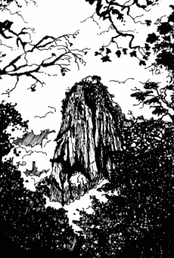
The spine of Tequila Volcano

The spine of Tequila Volcano. Drawing by Mark Eager (Western Mexico, A Traveler’s Treasury); all rights reserved.

Tequila Volcano, which overlooks the rolling fields of blue agaves required to make the liquor, is the home of one of Mexico’s most distinctive geomorphosites. From the rim of its crater, the most arresting thing about the view is not the green, tree-covered crater itself but the giant monolith with almost vertical sides rising perpendicularly from the middle of the crater floor.

This well-preserved central spine, known locally as la tetilla (“the nipple”) is quite unusual. It represents the hardened lava which cooled in the central vent of the volcano and which, solid and unyielding, was later pushed upwards by tremendous subterranean pressure.

Few such good examples exist anywhere in the world. The example most often quoted in geography texts is the spine that was pushed up by Mont Pelée on the island of Martinique in the West Indies in October 1902, immediately prior to that volcano’s disastrous eruption which cost 32,000 lives.

How to get there

A cobblestone road begins near the railway station in the town of Tequila and winds up Tequila Volcano towards the short-wave communications tower on its rim. It is about 20 kilometers from the town to the rim. The hike or drive up to the rim affords glorious views over the surrounding countryside. As you gain altitude, so the vegetation changes, becoming luxuriant pine-oak forest well before you reach the rim. Looking across the crater, on a day when clouds slowly drift across and partially obscure the view, is like watching a silent movie of ancient Chinese landscape drawings.

Want to read more?

For a fuller description of a visit to Tequila Volcano and a climb up the volcanic spine, see John and Susy Pint’s Outdoors in Western Mexico (2nd edition 2011).

For a description of Tequila Volcano and the varied villages and sights in its vicinity, see chapters 9 and 10 of my “Western Mexico: A Traveler’s Treasury” (Sombrero Books, 2013), also available in a Kindle edition.

Mexico’s geomorphosites: The Piedras Bola (Stone Balls) of the Sierra de Ameca, Jalisco

 Other  Comments Off on Mexico’s geomorphosites: The Piedras Bola (Stone Balls) of the Sierra de Ameca, Jalisco
Sep 272011
 

The Sierra de Ameca is a range of hills a short distance west of Guadalajara. The area was important in colonial times for gold and silver mining. One of the mines is called Piedra Bola (Stone Ball). The landscape immediately around this mine is so distinctive and unusual that it featured on the cover of the August 1969 edition of National Geographic.

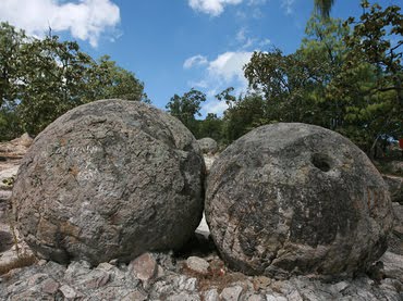
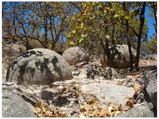
In the middle of the forest surrounding the Piedra Bola mine are about a hundred strange stone balls. They are almost perfectly spherical and range in diameter from about sixty centimeters to more than ten meters. These symmetrical boulders are unusually large. Nothing quite like them exists elsewhere in Mexico and few similar examples are known anywhere in the world.

Piedras Bola

Piedras Bola

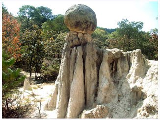
Some are buried, others partly or fully exposed. In some places, erosion of the surrounding rocks has left a sphere perched precariously atop narrow columns of softer rock, seemingly ready to topple in the next strong wind. These “hoodoos” or earth pillars have been formed as a result of water erosion and they may survive for centuries until the processes of sub-aerial weathering and erosion finally cause them to fall.

Piedra Bola atop an earth pillar

Piedra Bola atop an earth pillar

How were the Piedras Bola formed?

This summary of the most likely explanation of the origin of the stone spheres is based on that offered by Dr. Robert Smith of the U.S. Geological Survey in the original National Geographic article.

During the Tertiary geological era, 10-12 million years ago, a local volcano erupted, causing a deluge of glassy fragments of molten lava and ash, together with large quantities of volcanic gas trapped in the mixture. The mixture was very hot, probably between 550 and 800̊C. The deluge of material partially filled an existing valley, burying the former surface.

As the mixture cooled down, the existing glassy fragments formed nuclei around which much of the remainder of the material crystallized. Spherical balls began to form, their size depending on how long the crystallization process continued uninterrupted. The longer the time, the bigger the ball…. The most perfect balls were formed near the previous ground level, inside the hot mass of ashes, where the cooling would have occurred more evenly than in the bulk of the matrix material. The crystallized material is a kind of rhyolite which has an identical chemical composition to the fragments of glassy obsidian also found in the area.

The remainder of the ashes cooled down and became a consolidated accumulation of ashes and glassy fragments or tuff, without clearly defined spheres. This tuff is weaker, and has a lower density than the stone balls within it. During succeeding millenia, the combined processes of physical and chemical weathering weakened the surrounding tuff, and water (rain and rivulets) then eroded away this loose material, exposing some of the rhyolitic boulders completely and others partially.  As these processes continue, so more of the boulders will be exhumed from beneath their cover of tuff, and be revealed to us.

Protected?

The Jalisco State government has developed a small park around the Piedras Bola, including decent trails, some signposts and an amphitheater. There are even (reportedly) two ziplines, though I haven’t yet had the dubious pleasure of seeing them for myself. Increasing the number of visitors to  geomorphosites is not a bad idea, but some basic education and protection is needed if these and other geomorphological sites are going to be preserved intact for future generations. In the case of the Piedras Bola, graffiti now mar many of the exposed stone spheres and some of the spheres have been dynamited, apparently in the mistaken belief that the center of the sphere contained gold.

picture of piedras bolaHow to get there:

The entrance road to the Piedras Bola (formerly only a hiking trail) begins from km. 13 of the paved road that crosses the mountains from Ahualulco to Ameca. For anyone who does not have time for the hike, but still wants to see what these extraordinary stone spheres look like, the locals have thoughtfully rolled one down the mountain and onto Ahualulco’s main plaza.

Want to read more?

For more images and details, see John Pint’s article, Las Piedras Bola: the great stone balls of Ahualulco, on MexConnect, together with his outstanding gallery of photos.

Oct 082010
 

This year marks the centenary of the start of the Mexican Revolution. One of the fundamental causes of the Mexico Revolution in 1910, though by no means the only one, was the demand by landless campesinos (peasant farmers) for access to the means to control their own supplies of food. Revolutionary leaders called for the expropriation of the large estates or haciendas, which had been the principal means of agricultural production since colonial times, and the redistribution of land among the rural poor. A law governing this radical change in the land tenure system came into force in 1917 and the process has continued, albeit sporadically, into modern times.

About half of all cultivated land in Mexico was converted from large estates into ejidos, a form of collective farming. In most ejidos, each individual ejidatario has the rights to use between 4 and 20 hectares (10-50 acres) of land, depending on soil quality and whether or not it is irrigated. In addition, members of the ejido share collective rights over the use of local pasture and woodland. The system is similar to that in place in Aztec times. The maximum area of land that hacienda owners were allowed to keep varied with its potential use, from 100 hectares in the case of irrigated arable land to 300 hectares for land without irrigation.

By 1970 land redistribution had been more or less completed. Even so, most farming land still remained in the hands of a very small minority of farmers. Only 1% of farms were larger than 5000 hectares (12,355 acres) but between them they shared 47% of all farm land. Meanwhile, 66% of farms were smaller than 10 hectares (25 acres) yet they shared only 2% of all farm land. The ejido system did not produce the anticipated increase in food production or food security. Hacienda owners opted to keep their most productive land, meaning that many ejidos had to work land that was marginal at best. Many ejidatarios saw no need to pursue profits provided their families were well fed.

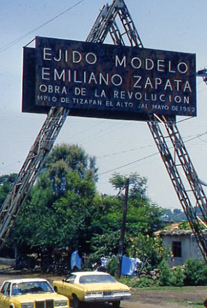
Entrance to Ejido Modelo Emiliano Zapata, Jalisco. Photo: Tony Burton

Many individual plots were too small for mechanization, and nutrients were rapidly depleted through constant use. Collective ownership of the land meant that individuals could offer no collateral for improvement loans. Many campesinos abandoned their ejidos and sought their futures elsewhere, migrating either to the big cities, for their range of manufacturing and service jobs, or to the USA. A sizable proportion of ejido land is no longer economically productive, but only in the 1990s was any mechanism put in place for ejido lands to be sold and revert back to private status.

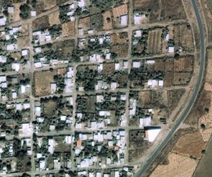
The photo shows the entrance to the “model ejido” of Emiliano Zapata, near Tizapán el Alto, Jalisco, on the southern shore of Lake Chapala. (nb. Despite the claims of Google Earth that this ejido is in the state of Michoacán, it is definitely in Jalisco, though relatively close to the state border.) The ejido has a population of about 2500. The Google Earth image clearly shows a dispersed rural settlement pattern, quite unlike the more usual nucleated villages of rural areas in most of Mexico. Each individual ejitario has a small plot of land around his/her house, and also has a share in the communal land beyond the perimeter of the settlement.

Google Earth image of part of Ejido Modelo Emiliano Zapata, Jalisco

This is an excerpt from chapter 15 of Geo-Mexico: the geography and dynamics of modern Mexico. Buy your copy today, and learn more about Mexico’s fascinating geography. Additional knowledge will greatly enhance the pleasures you derive during your next trip to Mexico.

Oct 042010
 

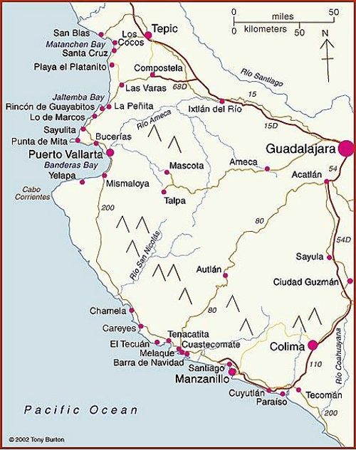
The map shows the coasts of the states of Colima, Jalisco and Nayarit. These states all have some great beaches, and tourism is an important activity in many of the towns shown on the map. Some of the beaches are so exposed that the Pacific Ocean waves arriving to smash into the sand offer outstanding surfing opportunities. Other beaches are more sheltered, with calmer waters perfect for swimming.

Map of Pacific Coast beaches. Copyright 2010 Tony Burton. All rights reserved.

Besides being important for tourism, Manzanillo is one of Mexico’s largest ports. One of the major reasons why the port of Manzanillo has attracted so much investment in recent decades is that it is easy to access via the major divided highway to/from Guadalajara and the interior of Mexico (and indeed, the US border).

Further north, San Blas was once an important port, but declined as silting blocked the shallow access routes. We described the historical geography of San Blas in a previous post:

Barra de Navidad also had great historical importance, as one of the shipbuilding ports where the Spanish built the ships which traversed the Pacific Ocean to the islands of the Philippines.

The coast around the headland of Punta de Mita used to be the site of rustic fishing villages, from where fisherman also took occasional groups of tourists out to sea whale-watching. This headland, and these villages became one of the best recent examples in Mexico of a forced migration:

In recent years tourism developments have caused more forced relocations than dam construction. One example is the Punta de Mita peninsula, 50 km (30 mi) north of Puerto Vallarta, developed in the 1990s. The existing residents, mostly fishermen, were forced from their homes on the coast so that their ejido lands could be converted into a luxury tourist resort and Jack Nicklaus-designed golf course.

The fishermen were moved from their breezy and somewhat ramshackle palapa huts, interspersed with palm trees, into ugly, concrete block houses a short distance inland, in the purpose-built small town of Emiliano Zapata, which adjoins a redeveloped coastal commercial/ restaurant strip called Anclote. Attempts by the developers to build the fishermen a small boat-building workshop and breakwater to protect the beach caused sand to be eroded from one of the only two remaining beaches with public access. During the resort’s construction an influx of workers from other parts of Mexico pushed prices up and led to social problems. (Geo-Mexico: the geography and dynamics of modern Mexico page 191)

More dramatic changes are now underway along part of this coastline. The area north of Sayulita (which has become a favored wintering location for Americans and Canadians) as far as the beach resort of Rincón de Guayabitos (favored by Mexican families) is slowly being transformed into Mexico’s latest purpose-built tourist resort, in the same way that other Mexican mega-resorts such as Cancún, Huatulco and Ixtapa were created.

Only time will tell what eventually happens to the areas that currently remain as genuine wilderness coast. One thing is sure – the more we develop this coastline, the more ecological damage will be done in the name of progress. Ecologically productive mangroves have been stripped out almost all along the coast, giving way to luxury hotels and marinas. Mangroves are now protected by federal law, but enforcement of this law may not be very effective.

Equally, fewer safe places now remain for the various endangered species of marine turtles who first visited these beaches a very long time before even the early Spanish mariners. One good sign is that active turtle protection programs exist at several of the beaches in this area. Ecological education is a good thing; ecological action is even better.

For more information about the geography of Mexico, buy your copy of Geo-Mexico: the geography and dynamics of modern Mexico today!

 Tagged with:

Map of the state of Jalisco, including Guadalajara, Puerto Vallarta and Chapala

 Maps  Comments Off on Map of the state of Jalisco, including Guadalajara, Puerto Vallarta and Chapala
Apr 212010
 

The state Jalisco (see map)  has an area of  78,609 square kilometers and a population of 7,070,555 (2010 estimate). The state’s capital city is Guadalajara, Mexico’s second largest city (2009 population: 4,365,000). On the outskirts of the city is an area of industry that is known as Mexico’s “Silicon Valley” because of its various computer-related factories.

The state is entirely within Mexico’s “Volcanic Axis” with varied scenery, encompassing everything from inland plateaus to rift valleys, volcanic peaks, calderas and coastal landforms. Its diverse altitudes mean that there are significant climate differences within the state.

Map of Jalisco. Copyright 2010 Tony Burton. All rights reserved.

Jalisco’s economy is very diversified. The state is a major agricultural producer, but also has an important manufacturing output, and also has a significant tourism industry, centered on the coastal resort of Puerto Vallarta. The villages of Ajijic and Chapala on the northern shore of Lake Chapala, Mexico’s largest natural lake, are the home to several thousand US/Canadian retirees.

Previous blog posts about Jalisco include:

Dec 172021
 

Christmas festivities in Mexico are not just a one-day wonder but extend over several weeks, and are already well underway!

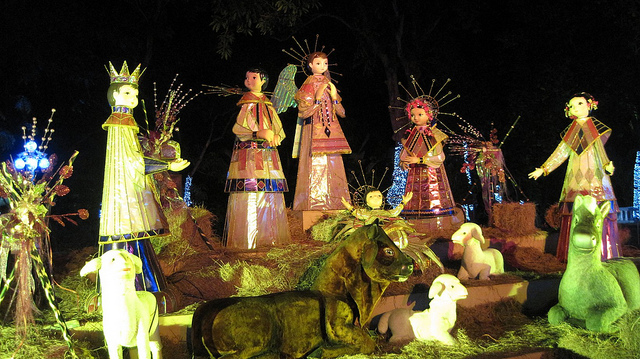
Nativity scenes such as this one are popular with all ages:

Modern Mexican Nacimiento. Photo: Ariaski (Flickr);

Modern Mexican Nacimiento. Photo: Ariaski (Flickr); creative commons license

Unlike in many other countries, the custom of gift-giving at this time of year was not tied to Christmas Day but to Three Kings Day (6 January), a custom that has changed rapidly with rampant advertising and commercialization of the holiday season:

Still looking for a Mexican-themed Christmas gift? Try any of these books (Kindle or soft cover) by Geo-Mexico co-author Tony Burton, available on all Amazon sites – Books on Mexico; this romance-adventure novel by Jan Dunlap, set in 1970s’ Mexico – Dilemma; or this beautifully-written memoir of a childhood in Mexico (Mexico City and Lake Chapala) – According to Soledad – by Katie Goodridge Ingram. For an inspiring and heart-warming non-fiction work, try Gwen Burton’s  New Worlds for the Deaf, which recounts the history of a pioneering school for the deaf in Jocotepec, Jalisco.

Mexico has had numerous unusual public Christmas trees in recent years, including:

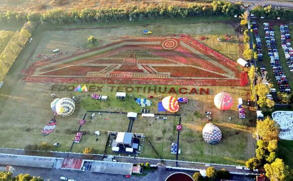
Mexico is the original home of the poinsettia, the decorative plant of choice for interior decorators during the festive season. This year, a massive (Guinness award-winning) floral carpet of poinsettias covering 17,805 square meters – mainly of white and red varieties – was arranged at the pyramids of Teotihuacan, just outside Mexico City:

Credit: Mexico Daily News / EdomexTurismo

Mexico also gave the world the turkey, corn and pumpkin pie:

Curiously, the idea of having a Christmas Tree at Christmas time in Mexico seems to be a relatively recent custom, an example of a “cultural invasion”:

The custom of having a family or community Christmas Tree has led to an ever-growing demand for Christmas trees, many of which are now grown and harvested in Mexico:

Christmas trees are not complete without Christmas ornaments and Mexican handicraft artisans have been cashing in on the demand for decades, especially in such creative states as Michoacán:

Some parts of Mexico work on Christmas most of the year! For example, the manufacturing of beautiful handmade Christmas tree decorations is the main industry today in the former gold and silver mining town of Tlalpujahua in the state of Michoacán. The production of Christmas ornaments in Tlapujahua has a great series of photos by Arturo Toraya of Notimex, showing some of the steps involved.

ornaments-2

As the accompanying text explains, “Making baubles for Christmas trees is the main source of jobs in the town, which is now one of the top five producers in the world. Due to their quality, 90 percent of the total production is exported to the U.S. and Canada. There are 200 family workshops in the town with seven-hour shifts, and each worker can make up to 550 baubles per day. Each workshop decorates about 500 per day. Red, blue, green and yellow are the top selling colors in Mexico, while black, brown and grey are more popular in the U.S.”

The village of Tzintzuntzan, on the shores of Lake Pátzcuaro, also in Michoacán, is another settlement where Christmas seems to be a year-round source of inspiration. The village handicraft market is a cornucopia of straw work in every conceivable color, design and size, which make ideal Christmas decorations or gifts.

Craft market in Tzintzuntzan, Michoacan

Craft market in Tzintzuntzan, Michoacan

Happy Christmas from Geo-Mexico! – ¡Feliz Navidad!

Ten new “Magic Towns” have been announced

 Mexico's geography in the Press  Comments Off on Ten new “Magic Towns” have been announced
Oct 122018
 

Ten new “Magic Towns” have been announced, bringing the total number nationwide to 121. The lates additions are:

  • Melchor Múzquiz, Coahuila
  • Nombre de Dios, Durango
  • Comonfort, Guanajuato
  • Zimapán, Hidalgo
  • Tlaquepaque, Jalisco
  • Compostela, Nayarit
  • Amealco de Bonfil, Querétaro
  • Aquismón, San Luis Potosí
  • Bustamante, Nuevo León
  • Guadalupe, Zacatecas

See also:

Tourism index page

 Index page  Comments Off on Tourism index page
May 232017
 

This Tourism index page lists the most relevant posts on Geo-Mexico related to tourism, including history of tourism in Mexico, types of tourism, major resorts, and current trends. It is updated periodically.

Importance of tourism:

History of tourism in Mexico, hotels, publicity campaigns:

Magic Towns:

Cancún and the Riviera Maya (Maya Riviera), Quintana Roo:

Huatulco and Oaxaca:

Acapulco:

Geotourism and ecotourism in Mexico:

Cruise ships:

Lake Chapala, Ajijic, Chapala and the Lerma-Chapala basin:

Megaproject proposals and conflicts over tourism:

Specialized forms of tourism (tourism niche markets):

Other (miscellaneous):

Other Geo-Mexico index pages:

Mexico and Ireland: a lasting relationship forged by potatoes. Happy St. Patrick’s Day!

 Other  Comments Off on Mexico and Ireland: a lasting relationship forged by potatoes. Happy St. Patrick’s Day!
Mar 152017
 

In honor of St. Patrick’s Day, we offer this short list of references highlighting some of the more significant connections between Ireland and Mexico.

Séamus Ó Fógartaigh in his “Ireland and Mexico“, published in Irish Migration Studies in Latin America by the Society for Irish Latin American Studies (based, curiously, in Switzerland) looks at the early links between Ireland and Mexico, including suggestions that the travels of St. Brendan the Navigator may have inspired Christopher Columbus and that the famous “Plumed Serpent” of Mexican mythology may have originated from the deification of an Irish monk.

Much better known are the later links. During colonial times, several of the Spanish administrators sent to New Spain (now Mexico) were direct descents of Irish exiles to Spain. They include the 63rd and last Spanish Viceroy of New Spain Juan O’Donojú (formerly O’Donoghue) who arrived in the New World shortly before Mexico became Independent in 1821.

A generation later, Irish soldiers who chose to leave (deserted) the US army formed the backbone of Mexico’s St. Patrick’s Battalion (Batallón San Patricio) which fought the invading Americans in 1846-48. They are especially remembered for their bravery in the Battle of Churubusco (in Mexico City) in 1847. Their story is well remembered by Mexicans today, their exploits commemorated every year at a ceremony in Mexico City, and the basis of several books and the movie One Man’s Hero. The single, best account is that by Michael Hogan in The Irish Soldiers of Mexico. For a summary account, try “The St. Patricio Battalion, The Irish Soldiers of Mexico” by Jaime Fogarty, published in UNAM’s Voices of Mexico magazine, April-June, 2000.

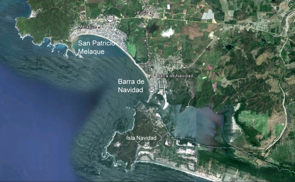
San Patricio Melaque (Google Earth)

San Patricio Melaque (Google Earth)

On the Jalisco coast, the small town of San Patricio Melaque (around the bay from Barra de Navidad and the Isla de Navidad tourist development) holds an annual fiesta that celebrates both the town’s patron saint and the achievements of the Irish soldiers. Nine days of activity (church services, fireworks, parades, bullfights, fairground games) come to a climax on 17 March. (It is sometimes claimed that San Patricio Melaque is the only settlement named San Patricio in Mexico, but that is not quite true, since there are at least three others: two tiny hamlets called San Patricio, relatively close to Cd. Victoria in Tamaulipas, and one named San Patricio de la Mesa in the mountains east of Hermosillo in Sonora.)

In the twentieth century, Álvaro Obregón (family name O’Brien) was President of Mexico from 1920 to 1924. (We will take a critical look at his relationship with the indigenous Yaqui Indians of Sonora in a later post). The city of Ciudad Obregón in Sonora is named in his honor. Artists of Irish descent also impacted Mexico’s national life. They included architect, painter and muralist Juan O’Gorman (1905-1982), responsible for the monumental mosaic that adorns the walls of the National University (UNAM) Library in Mexico City, and a striking, colorful mural in Pátzcuaro that depicts an erupting volcano; this mural was completed just one year before the unexpected eruption nearby of Paricutín Volcano.

Today, according to Wikipedia, there are between 300,000 and 600,000 people of Irish descent living in Mexico, mostly in either northern Mexico or Mexico City.

Dr. Michael Hogan has done far more than most to publicize the links between Ireland and Mexico.

Most of the links we’ve described might never have happened if Mexico had not sent an unwanted export to Ireland in the middle of the nineteenth century. The census of 1841 in Ireland recorded a population of about 8 million. The staple Irish food at that time was the humble potato and Ireland’s rapid population growth during the early part of the nineteenth century was based on the so-called “potato economy”.  Ireland was bursting at the seams in 1841, but just a decade later, after the potato famine, the population had fallen to 6.5 million. The cause of the Irish potato famine was a water mold (Phytophthora infestans) that originated in Mexico and crossed the Atlantic in the 1840s, reaching Europe in 1845 before rapidly spreading across the continent to reach Ireland.

If a Mexican water mold had not provoked the Irish potato famine, maybe there would have been no settlements named San Patricio in Mexico today, and no cause to celebrate St. Patrick’s Day in Mexico! Wherever you may be, have a very Happy St. Patrick’s Day!

Related links:

The development of Huatulco, the tourist resort in southern Oaxaca

 Other  Comments Off on The development of Huatulco, the tourist resort in southern Oaxaca
Jan 302017
 

Huatulco is best known as one of Mexico’s leading tourist resorts, one of several similar large-scale, purpose-built developments partially funded by federal funds.

In 1967, responding to bullish predictions of US demand for beach vacations, Mexico’s central bank identified the five best places for completely new, purpose-built tourist resorts. Top of the list, as part of a 30-year plan, was the uninhabited barrier island now known as Cancún (see The growth of Cancún, Mexico leading tourist resort). The other choice locations were Ixtapa, Los Cabos, Loreto and Huatulco. The National Fund for Tourism Infrastructure (renamed the National Tourism Development Fund, Fonatur, in 1974) began building Cancún in 1970 and Ixtapa in 1971.

Huatulco’s site on the coast of Oaxaca had been initially identified in 1969 but the area lacked adequate transportation infrastructure until the regional highways were improved in 1982. Legal land expropriations followed; by 1984 Fonatur controlled more than 21,000 hectares (50,000 acres). In 1985 Fonatur began construction of an airport and a service town, La Crucecita, a few kilometers back from the coast. In 1986 the villagers of the coastal community of Santa Cruz were resettled in La Crucecita. Most of Huatulco’s nine bays were linked by paved road by 1987 (see map).

Sketch map of Huatulco (not to scale)

Sketch map of Huatulco (not to scale)

Fonatur took a number of steps to help the original residents adapt to the massive changes taking place around them. It built schools, held public meetings, provided medical and police services, and offered job training programs. Most people gradually adapted; some are employed in Huatulco hotels and some started their own small businesses. By 1994 Huatulco had 1905 hotel rooms and attracted 170,000 tourists, 26% of them foreign. The average length of stay was 4.22 days.

Huatulco’s growth has not been as rapid as Cancún’s. By 2006, Huatulco had 2506 rooms and played host to 312,000 tourists (15% foreign). While Cancún first attracted Mexican tourists and then foreign tourists followed (and now dominate), in Huatulco the proportion of foreign tourists has fallen as the resort has developed. The master plan for Huatulco foresees 30,000 hotel rooms and a city with an eventual population of 600,000.

As for most of its other developments, Fonatur’s construction of La Crucecita established a clear spatial and visual divide between the tourist areas on the coast and the residential areas for tourism employees, in this case on the inland side of some low hills.

So far, so good, but critics of centrally-planned, “top-down” resorts like those built by Fonatur, and of Huatulco in particular, point to the tremendous strains placed on the local inhabitants and on the local environment. We look at some of these in more detail in Villages near Huatulco, Oaxaca: a case study in the “Integrated Administration of Natural Resources”

Related posts:

The geography of tequila: where is tequila made?

 Other  Comments Off on The geography of tequila: where is tequila made?
Nov 142016
 

The production of (genuine) tequila is tightly regulated because tequila has denomination of origin status. This status (sometimes called appellation of origin) sets specific standards for producers in terms of how a product is grown or produced, processed and presented. Equally importantly, it defines the geographic indication, the specific places or regions where the product has to be made. Other items having denomination of origin status include champagne, asiago cheese and Melton Mowbray pork pies.

Geographic indications are “indications which identify a good as originating in the territory of a Member, or a region or locality in that territory, where a given quality, reputation or other characteristic of the good is essentially attributable to its geographic origin.” (World Trade Organization)

Mexico’s denomination of origin area for genuine tequila includes includes 180 municipalities in five states, a total area of about 11 million hectares (27 million acres).

Tequila producing areas of Jalisco and neighboring states.

Tequila producing areas of Jalisco and neighboring states. Credit: Tony Burton; all rights reserved. Click to enlarge

The main area (see map above) is the state of Jalisco (all 124 municipalities), with extensions into three neighboring states:

  • Nayarit (8 municipalities): Ahuacatlán, Amatlán de Cañas, Ixtlán del Río, Jala, Xalisco, San Pedro Lagunillas, Santa María del Oro and Tepic.
  • Guanajuato (7 municipalities): Abasolo, Cd. Manuel Doblado, Cuerámaro, Huanimaro, Pénjamo, Purísima del Rincón and Romita.
  • Michoacán (30 municipalities): Briseñas de Matamoros, Chavinda, Chilchota, Churintzio, Cotija, Ecuandureo, Jacona, Jiquilpan, Maravatío, Marcos Castellanos, Nuevo Parangaricutiro, Numarán, Pajacuarán, Peribán, La Piedad, Régules, Los Reyes, Sahuayo, Tancítaro, Tangamandapio, Tangancicuaro, Tanhuato, Tinguindín, Tocumbo, Venustiano Carranza, Villa Mar, Vista Hermosa, Yurécuaro, Zamora, and Zináparo.
Tequila growing area in Tamaulipas.

Tequila growing area in Tamaulipas. Credit: Tony Burton; all rights reserved. Click to enlarge.

About 80% of all blue agave is grown in Jalisco, and almost all tequila distilleries are located in the state.

The municipality of Maravatío in the eastern section of Michoacán is a tequila outlier, some distance away from the main producing area centered on Jalisco.

The other major outlier is a group of 11 municipalities in the northern border state of Tamaulipas (see second map) where 11 municipalities (Aldama, Altamira, Antiguo Morelos, Gómez Farías, González, Llera, Mante, Nuevo Morelos, Ocampo, Tula and Xicotencatl) are included in the denomination of origin for tequila.

The first denomination of origin for tequila was registered with the World Intellectual Property Organization in 1978. Since that time every trade agreement signed by Mexico has contained a clause to ensure that tequila’s special status is fully protected by the other signatories. Mexico has signed free trade agreements with more countries than any other country in the world.

For example, the relevant NAFTA clause states that:

“Canada and the United States shall recognize Tequila and Mezcal as distinctive products of Mexico. Accordingly, Canada and the United States shall not permit the sale of any product as Tequila or Mezcal, unless it has been manufactured in Mexico in accordance with the laws and regulations of Mexico governing the manufacture of Tequila and Mezcal.”

In 1996, Mexico succeeded in getting the World Trade Organization to recognize tequila, and also mezcal, as denomination of origin products.

The following year, Mexico signed an agreement with the European Union whereby Mexico recognized 175 European spirits, including champagne, cognac, grappa and scotch, as having denomination of origin protection, in exchange for E.U. protection for tequila and mezcal. At that time, Mexico’s Tequila Regulatory Council (CRT) estimated that some 3.5 million liters of “pseudo-tequilas” were sold annually in Europe under such names as “Blue Tarantula” in Italy and “Hot Tequila” in Finland (In search of the blue agave: Tequla’s denomination of origin).

Related posts:

Nov 072016
 

In a previous post – Mexico’s shoe (footwear) manufacturing industry: regional clustering – we looked at the concentration of the shoe-manufacturing industry in three major areas: León (Guanajuato), Guadalajara (Jalisco) and in/around Mexico City. We have also taken a look at Mexico’s international trade in shoes – Mexico’s footwear industry: imports and exports. We now turn our attention to the distribution of shoe retailers within a large Mexican city.

Shoes in Mexico

The retailing of shoes within cities often exhibits distinctive spatial patterns. Many older and larger Mexican cities tend to have all the retailers for a particular item (furniture, electronics, autoparts, etc) concentrated in a very small area. For example, dozens of retail outlets for electronics are located within a few blocks of Mexico City’s main square or zócalo. Electronics stores are in very close proximity to one other, and occupy both sides of the street for several blocks, leaving little or no room for any other retailers.

Another example of retail specialization is Corregidora street, which has several blocks dedicated to the sale of pots and pans, kitchen utensils and table settings.

Elsewhere in Mexico City’s downtown area:

… turn right and continue down Chile street to the intersection with Tacuba street. One of the most fascinating aspects of commercial life in the downtown area of Mexico City is that each area is specialized in some trade or retail activity. Such trading ghettos were also a feature in Tenochtitlán and the practice still exists today. Where you are now walking is the barrio of bridal shops. The greatest concentration of these shops is north of the Heras y Soto House…” (Candace Siegle, Walking through History, a series of walks through Mexico City’s historic center, 1989)

Returning to the subject of shoes, without which no bridal outfit is complete, shoe retailing is also often heavily concentrated in certain sections of Mexico’s larger cities. Perhaps the most extreme example is in Guadalajara, where shoe retailing is concentrated in two main zones. One of these zones is within the central business district, and is comprised of both regular storefronts and a market. The other area is several kilometers west of the center, around Galería del Calzado, a shopping plaza of more than 60 stores entirely dedicated to shoes. The Galería, located where Yaquis meets Avenida México, has a total floor space in excess of 8,600 square meters (92,500 square ft). The shops in Galería del Calzado stock every major brand and type of shoe, and eagerly compete for your pesos.

From a consumer’s perspective, this is all highly convenient and allows for easy comparison shopping. However, I have never been convinced of the advantages of such concentration from the point of view of the retail store owners, unless perhaps they get their stock from a relatively limited number of (shared) shoe distributors?

Despite the success of many Mexican shoe manufacturers, one of the fundamental weaknesses of the supply chain for footwear in Mexico (according to sector analysts) is the absence of any strong specialized marketer dedicated to shoes. Fancy a job marketing cowboy boots, anyone?

Related posts:

Chapters 21 and 22 of Geo-Mexico: the geography and dynamics of modern Mexico analyze Mexico’s 500-year transition to an urban society and the internal geography of Mexico’s cities. Chapter 23 looks at urban issues, problems and trends. Buy your copy of this invaluable reference guide today!

Basalt columns and prisms can be seen in various places in Mexico

 Other  Comments Off on Basalt columns and prisms can be seen in various places in Mexico
Oct 252016
 

Basalt is a dark, fine-grained, basic (low silica) igneous rock, often extruded as molten lava from volcanic fissures. Its low silica content means it can flow easily, often building up over the years to form large plateaus. As the basaltic lava cools, it contracts and solidifies. An extensive network of cracks often develop in basalt, which may extend many meters deep. These cracks tend to leave columns between them which are roughly hexagonal (6-sided) in shape. Among the more famous examples of basalt columns or pavements in the world are Giant’s Causeway (Northern Ireland), Fingal’s Cave (Scotland) and Devil’s Postpile (California, USA).

The best known location in Mexico to see basalt columns is about an hour’s drive north of Mexico City, at Santa María Regla, in the state of Hidalgo. These columns, attractively located on the side of a canyon, with a waterfall tumbling over some of them (see sketch), were visited by the famous Prussian scientist/geographer Alexander von Humboldt, during his exploration of Mexico in 1803-04. Some individual columns are 40 meters tall.

Basalt prisms at San Miguel Regla

Basalt prisms at San Miguel Regla, from Humboldt and Bonpland, Vues des Cordilleres et monumens des peuples indigenes de l’Amerique.

The basalt columns of Santa María Regla are one of the locations described in The first geography fieldtrip guide in Mexico. They are also one of Mexico’s top 13 natural wonders.

Basalt prisms at Santa María Regla

Other locations in Mexico where basalt columns or prisms can be seen include a quarry between the towns of Jamay and Ocotlán (Jalisco), the south-facing slope of the hills overlooking the town of Chapala (Jalisco) and the Salto (waterfall) de San Antón (Cuernavaca, Morelos).

Mexico’s geology and landforms are analyzed in chapters 2 and 3 of Geo-Mexico: the geography and dynamics of modern Mexico.  Buy your copy of this book today!

Sep 262016
 

Lake Chapala is Mexico’s largest natural lake. On the geological timescale of millions of years, all lakes are temporary features on the earth’s surface. Once formed, natural processes begin to fill them in and/or to drain them.

Map of Lake Chapala, Jalisco, Mexico. All rights reserved.

Lake Chapala resulted from drastic earth movements, accompanied by earthquakes and faulting which occurred some twelve million years ago. Lake Chapala collected on the floor of a rift valley. Movements along the parallel systems of faults that caused the rift valley still occur today. Evidence for this continued movement can be seen in the cracked or displaced walls of some local buildings.

Given its advanced age, it is not surprising to discover that Lake Chapala was once (thousands of years ago) much larger. In fact, though no-one has so far proven it beyond doubt, it may have been immensely large, covering an area seven times its present area, with a correspondingly long shoreline. At a later stage in its history, it became the deepest lake of an interconnected series of lakes which flooded the valley floors where the towns of Jocotepec, Zapotitan, Zacoalco and Sayula are today. The present Lake Chapala is thus probably only a small remnant of the original version.

The lake is under heavier pressure than at any time in its existence. Local towns and the nearby city of Guadalajara see it as an inexhaustible supply of domestic and industrial water. Tourists see it as a recreation resource, and the thousands of foreign retirees who have settled on its shores see it as a major reason for the area’s beneficial climate.

A case study of ‘residential tourism’ in the villages on the northern shore of Lake Chapala is discussed in chapter19 of Geo-Mexico: the geography and dynamics of modern Mexico.

The levels of flow of the River Lerma, the only river of any size entering the lake, are crucial to the health of the lake. In recent years, demands for Lerma water have multiplied many times over, principally for farms in neighboring states, but also for industries. All the other rivers entering the lake are much smaller and, with rare exception, flow into the lake only a few times a year during the rainy season. The hydrology of Lake Chapala is discussed in chapters 6 and 7 of Geo-Mexico: the geography and dynamics of modern Mexico.

The good news is that Lake Chapala was recently declared an Internationally Important Wetland by the Ramsar Convention, joining a large global network of similarly important wetland sites. The 13th International Living Lakes Conference was held in Chapala, March 22-25, 2010.

This is an edited excerpt from Tony Burton’s Western Mexico, A Traveller’s Treasury (4th edition) .

Which are the best states in Mexico for doing business in 2016?

 Mexico's geography in the Press  Comments Off on Which are the best states in Mexico for doing business in 2016?
Sep 232016
 

A study just released by the World Bank and the International Finance Corporation, Doing Business en México 2016, compares Mexico’s 32 states for the paperwork, time and costs associated with four major indicators: opening a new business, obtaining construction permits, registering industrial property rights and the resolution of commercial disputes.

The report concludes that the seven best states in which to do business are Aguascalientes, the State of Mexico, Colima, Puebla, Sinaloa, Guanajuato and Durango, all of which offer a better performance than the average for OECD high income countries.

doing-business-2016-fig-1-2

Overall ranking for Doing Business in Mexico 2016 (Source: Fig 1-2 of World Bank Report)

The three states that have advanced the most towards implementing international best practices since 2014 are Puebla, Jalisco and the State of México.

The map shows the rank order of states for doing business, from green (the best) to red (the lowest ranking). Unlike many maps of state-by-state performance, this map does not show any evidence for the north-south divide we have repeatedly commented on in the past.

Related posts:

Sep 142016
 

The battle in question is the Battle of Calderón Bridge (Batalla del Puente de Calderón), fought just outside Guadalajara in January 1811 as part of Mexico’s fight for Independence. The decisive battle was waged on the morning of Thursday, January 17.

On one side was Ignacio Allende with some 80,000 ill-equipped and untrained supporters of Father Miguel Hidalgo, the priest who launched Mexico on the road to Independence. On the other side was the numerically much smaller, but professional, Royalist army led by General Félix María Calleja, fighting for the King of Spain .

After six hours of fighting, a stray grenade from the Royalist side landed smack in the middle of the insurgents’ ammunition supplies, resulting in a fearful explosion and fire which brought the battle to a speedy end. Hidalgo and his men fled northwards; the crown troops followed, hot on their heels. The loss of this battle effectively dashed hopes of any quick independence from Spain. Mexico’s  Independence was delayed another ten years, until 1821.

The area where this important battle took place is between Guadalajara and Tepatitla, in the state of Jalisco. A few kilometers beyond Zapotlanejo, the site is clearly marked by a large monument to Father Hidalgo, prompting one to reflect on how often the losers of a battle are commemorated, rather than the winners. The statue overlooks the battlefield: the shallow valley of the Calderón river. In Hidalgo’s time, only a single bridge spanned the river. It was made a national monument in 1932.

Today, three different bridges exist in the general vicinity of the battle and a fourth, not far away, is used by the toll highway to Lagos de Moreno. It’s easy to tell which of the four bridges is the correct one, since it has a plaque commemorating the event!

Curiously, the historically-accepted plan of the battle, reproduced in dozens of scholarly works and hung on display in many museums around the country (still including, to the best of my knowledge, the Regional Museum in Guadalajara) is in fact, upside down! The true orientation of the map was proven (way beyond any reasonable doubt) by Mexican geographer Alma Rosa Bárcenas. In a brilliant and clearly written article, which appeared in the first isue of “Geografía”, published by INEGI in Mexico City in 1986, she clears up the confusion surrounding the exact site of the battle.

She proves, using both field-work and aerial photographs to supplement contemporary battle descriptions which give clues to terrain, slopes and visibility, that the map was drawn “south-upwards”. The map’s “north arrow” actually points due south!

Here is the battle plan the right way round. At last, the battle descriptions make sense! Now, anyone visiting the battle site has a chance to work out for themselves the true dispositions of the troops on both sides, and relive, if only in their imagination, the course of this key battle in Mexico’s War of Independence…

This is an edited version of an article originally published on MexConnect. Click here for the original article

Geo-Mexico: the geography and dynamics of modern Mexico takes an in-depth look at the implications of Mexico’s 1810-1821 War of Independence for the development of transportation and communications systems, as well as migration patterns, settlements and many other aspects of Mexico’s geography and development.

As an added bonus, it has no maps that are upside-down!

Hidden Beach, aka Beach of Love, reopens

 Mexico's geography in the Press  Comments Off on Hidden Beach, aka Beach of Love, reopens
Sep 012016
 

Mexico’s famed Hidden Beach (Playa Escondida), aka as the Beach of Love (Playa del Amor), has reopened for limited tourism following a three month closure  for cleaning and restoration work.

The beach is on one of the small, uninhabited Marieta Islands, in the Marieta Islands National Park, off the west coast of Mexico, and relatively close to the resort of Puerto Vallarta. It is one of Mexico’s most beautiful small beaches, looking from the air (image) like an “eye to the sky”.

Playa Escondida. Source: Google Earth. Scale: The beach is about 30 m (100 ft) long.

Playa Escondida. Source: Google Earth. Scale: The beach is about 30 m (100 ft) long.

In earlier posts, we considered how Playa Escondida (“Hidden Beach”) was formed and also looked at the not inconsiderable downside to publicizing one of Mexico’s most beautiful beaches.

After a study by University of Guadalajara researchers found that local coral was dying and argued that the beach could support no more than 625 visitors a day (compared to the estimated 2500 who visit it on vacation days), federal authorities closed the beach and prohibited access while they considered how best to regulate future visits.

Mexico’s National Protected Areas Commission (Conanp) has now announced new regulations governing visits to the island and to the beach. It is limiting visitors to 116/day, well below the University of Guadalajara figure for carrying capacity of 625/day/.

In addition, no single group may have more than 15 members. No diving is allowed. Fins, face masks and snorkels are all prohibited. Visits have a strict time limit of 30 minutes. The beach, visted by more than 125,000 in 2015, will be completely closed two days each week for maintenance and monitoring.

Only time will tell if these measures will be sufficient to ensure that this particular gem of Mexico’s hundreds of amazing geosites will still be there for future generations to admire and appreciate.

Related posts

Aug 182016
 

Despite having seen this tourist promotion logo thousands of times, I had never thought about its colors and their significance until recently.

mexico tourism logoIt turns out that the colors (despite what you may see on your monitor) are actually meant to be:

  • M – brown = archaeology and archaeological sites (historical tourism)
  • é – pink = health and well-being (including medical tourism)
  • x – yellow = culture (cultural tourism)
  • i – purple = meetings (seminars and conference tourism)
  • c – green = nature (adventure tourism and ecotourism)
  • o – blue = sea, sun and sand (beach and resort tourism)

The federal Tourism Secretariat is planning a nationwide overhaul of tourism signage on major highways taking advantage of these colors. It will install new, standardized signs using these six colors as a quick means of identifying the kind of tourist attraction at each location of interest. The program has funding of almost $10 million, and the first states to have the new signs will be Chiapas, Durango, Guanajuato, Hidalgo, Jalisco, Michoacán, Puebla, Tabasco, Tlaxcala and Veracruz.

Whether or not using six different colors is actually more effective than six distinct symbols on the same color background remains to be seen.

In the first half of this year, Mexico received 17,000,000 international tourists, 8.6% more than for the corresponding period in 2015, with expenditures by tourists rising 8% to $10.063 billion.

Related posts: