Search Results : jalisco

Mexcaltitán, a magical island town in Nayarit

 Other  Comments Off on Mexcaltitán, a magical island town in Nayarit
Nov 102014
 

A short distance north of San Blas, in Nayarit, is a small island called Mexcaltitán. With barely four thousand inhabitants, it would scarcely be expected to have any real link to Mexico City, the world’s greatest metropolis of some twenty million people. But it does, and the link is to be found in the amazing story of the founding in 1325 of the Aztec capital Tenochtitlan, the city which was later conquered and sacked by the Spanish and rebuilt as Mexico City.
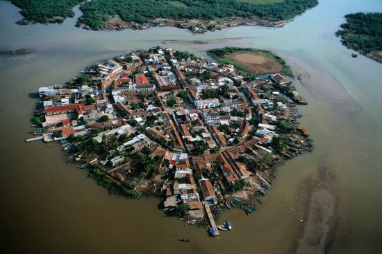
The island and village of Mexcaltián, Nayarit

The island and village of Mexcaltián, Nayarit

Historians have long wondered about the origins of the Mexica people, or Aztecs as they later became known. There is virtually no evidence of them before they founded the highly organized city of Tenochtitlan in 1325. Clearly such a civilization cannot just have sprung up overnight. So, where did they come from? Mexica (Aztec) legend tells of a long pilgrimage, lasting hundreds of years, from Aztlán, the cradle of their civilization, a pilgrimage during which they looked for a sign to tell them where to found their new capital and ceremonial center. The sign they were looking for was an eagle, perched on a cactus. Today, this unlikely combination, with the eagle now devouring a serpent, is a national symbol and appears on the national flag.

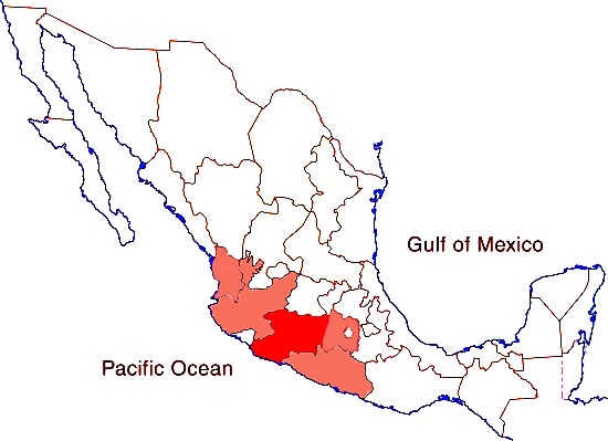
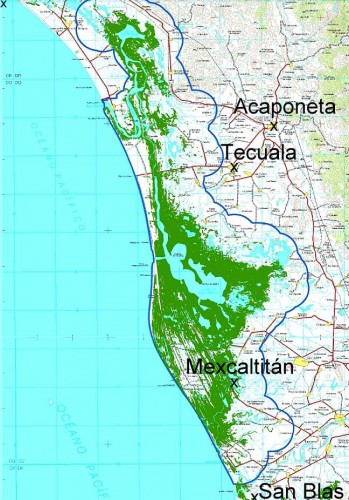
Map showing location of Marismas Nacionales

Map showing location of Marismas Nacionales

In recent years more and more evidence suggests that Aztlán may be far from mythical and that Mexcaltitán, the island in Nayarit, could be its original site. Ancient codices (pre-Columbian hand-painted manuscripts) prove that the Aztecs’ search for a new place to live was ordained by Huitzilopochtli, their chief god. It began in about AD1111 when they departed from an island in the middle of a lake. Their two hundred year journey took them through present-day Nayarit, Durango, Zacatecas, Jalisco, Michoacán, Guanajuato and Querétaro, and they may well have rested awhile on encountering familiar-looking islands in the middle of lakes such as Chapala and Pátzcuaro.

One of Huitzilopochtli’s alternative names was Mexitli and the current spelling of Mexcaltitán could be interpreted as “Home of Mexitli”, or thus, “Home of Huitzilopochtli”. In fairness, it should be pointed out that if the original spelling was Metzcaltitán (and “tz” often became transliterated to “x” down the centuries), then the meaning would become “Place next to the home of the Moon”.

Whatever the etymology of the name, early codices such as the Boturini Codex show the early Aztecs setting out from an Aztlán surrounded by water, in small canoes. The Mendoza Codex, depicting life in Tenochtitlan, has illustrations of similar canoes and, in both codices, the canoes and method of propulsion by punting show remarkable similarity to the present-day canoes of Mexcaltitán. Visitors to the island still have to undertake a canoe or panga ride to reach the village and it is an intriguing thought that the Mexica/Aztecs were doing exactly the same over eight hundred and fifty years ago.

Further evidence comes from an old map of New Spain. Drawn by Ortelius in 1579, it shows Aztlán to be exactly where Mexcaltitán is to be found today, though perhaps at the time this was largely conjecture.

The street plan of Mexcaltitán, best appreciated from the air, is equally fascinating. Two parallel streets cross the oval-shaped island from north to south, and two from east to west, with the modern plaza in the middle, where they intersect. The only other street runs around the island in a circle, parallel to and not far from the water’s edge. This street may have been the coastline of the island years ago and may even have been fortified against the invading waters of the rising lake each rainy season. Today, as then, for several months in summer the streets become canals, bounded by the high sidewalks each side and Mexcaltitán becomes Mexico’s mini-Venice as all travel has to be by canoe.

This street pattern has cosmic significance. It divides the village into four quarters or sectors each representing a cardinal point, reflecting the Mexica conception of the world. The center can be identified with the Sun, the giver of all life. The Spanish, as was their custom, built their church there, and today the central plaza with its bandstand is the obvious focal point of the community. Small shops, a billiards hall, a modern, well-laid out museum, and an administrative office complete the central area of the village.
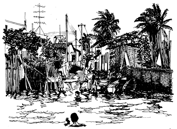
 

Mexcaltitán pen and ink drawing by Michael Eager

Mexcaltitán (pen and ink drawing by Michael Eager from chapter 26 of Western Mexico, A Traveler’s Treasury). All rights reserved.

Low houses, of adobe, brick and cement, line the dirt streets and extend right down to the water’s edge, in some cases even over the water’s edge into the surrounding lake, on stilts. Land on the island is at a premium and, with an ever-growing population, saturation point is very near.

A century ago, the locals turned on some foreigners who came to hunt female egrets, valued for their plumes back in the days when feathers adorned fashionable ladies’ hats. Today, provided only photos are taken, all visitors are welcomed! The villagers celebrate one of the most unusual and distinctive fiestas in all of Latin America. On 29 June each year they organize a regatta which consists of a single race between just two canoes, though naturally hundreds of other pangas are filled with spectators. One of the competing canoes carries the statue of Saint Peter from the local church, the other carries Saint Paul.

Elaborate preparations precede the race. The village streets are festooned with paper streamers and the two canoes are lavishly decorated by rival families carrying on an age-old tradition. The Ortíz family is responsible for St. Peter’s canoe, the Galindo family for St. Paul’s. The statues of the two saints are taken from the church and carried in procession to the boats. A pair of punters has previously been chosen from among the young men of the village for each boat. The punters have been suitably fortified for the contest with local delicacies such as steamed fish, shrimp empanadas, and the local specialty, tlaxtihuile, a kind of shrimp broth. Each boat, in addition to the punters and the statue of the saint, carries a priest to ensure fair play. The race starts from the middle of the eight kilometer long lake after a short religious service in which the priests bless the lake and pray for abundant shrimp and fish during the coming year. Then surrounding spectator canoes, some with musical bands, and others shooting off fireworks, move aside and the race begins.

Nowadays, St. Peter and St. Paul take it in turns to win, most considerate in view of the violence which years ago marred the post-race celebrations when the race was fought competitively. The ceremonial regatta safely over, land based festivities continue well into the night.

A canoe ride around the island takes about 30 minutes and provides numerous photo opportunities as well as many surprises including a close-up view of the island’s only soccer pitch—in the middle of the lake, under half a meter of water. The local children are, perhaps not surprisingly, expert “water soccer” players, a fun sport to watch.

Even if you’re not interested in the island’s past and are unable to see it on fiesta day, your trip to Mexcaltitán will be memorable. This extraordinary island and its village have to be seen to be believed.

The island is reached from the Tepic-Mazatlán highway, Highway 15. There are two alternatives. The northern route is signposted 73 kilometers north of Tepic; it starts with 26 kilometers of paved road crossing swampy paddy fields, followed by 16 kilometers of well-graded dirt road to Ticha, the landing-stage for boats to the island. The drive is through a naturalist’s paradise, teeming with wildlife. The equally scenic southern route begins 57 kilometers from Tepic and is via Santiago Ixcuintla (basic hotels only; don’t miss visiting the center for Huichol Indian culture and crafts) and Sentispac. It leads to the La Batanga landing-stage, and is fully paved.

Note:

This post is based on chapter 26 of my “Western Mexico: A Traveler’s Treasury” (link is to Amazon’s “Look Inside” feature), also available as a Kindle edition or Kobo ebook.

Related posts:
Mexico’s 2013 avocado harvest and exports

 Updates to Geo-Mexico  Comments Off on Mexico’s 2013 avocado harvest and exports
Oct 042014
 

Mexico is the world’s largest producer and exporter of avocados. The avocado harvest for the 2013/14 season was close to 1.5 million metric tons, a new record. More than 90% of Mexico’s avocados are grown in the state of Michoacán, where 12% of all agricultural land is currently under avocado orchards.

Avocado-growing states

Avocado-growing states

Mexico produces about 1.5 million metric tons of avocados a year, on 170,000 hectares in 27 states. The principal producing states are Michoacán 1.2 million tons, Jalisco 87,000; State of México 56,000; Nayarit 34,000; Morelos 27,000; Guerrero 14,000.

Avocado exports have risen sharply and, in the first half of 2014, totaled 353,000 metric tons, worth 800 million dollars, 29% higher than for the same period a year earlier. The most important markets for Mexican avocados are the U.S., Japan, Canada, Central America and Europe, but demand for avocados in Asia, especially China, is rising very quickly.  Exports to China rose 724% for the period to 1,260 metric tons, worth 3 million dollars.

Exports to the USA of avocados were worth 651 million dollars, 31% higher than a year ago; exports to Japan reached 62 million dollars, up 29%; and to Canada 41 million dollars, up 33%.

Related posts

Mexico hosts 2014 World Tourism Day

 Books and resources, Mexico's geography in the Press  Comments Off on Mexico hosts 2014 World Tourism Day
Sep 272014
 

Today Mexico is hosting World Tourism Day, so this seems like a good time to review the state of Mexico’s tourism sector. The official celebrations are being held in the city of Guadalajara.

The decision by The World Tourism Organization that Mexico should host the 2014 World Tourism Day recognizes Mexico’s importance in world tourism. Mexico is the 13th most popular international destination in the world. In 2013, it welcomed 23.7 million international tourists, who spent 13.8 billion dollars in the country. World Tourism Day 2014 highlights tourism’s social, cultural, political and economic benefits, and its importance in community development.

Earlier this year, Mexico’s Tourism Secretariat published a detailed analysis of the Tourism Industry in Mexico in 2013.

The text of the magazine format publication (link above) is in Spanish, but it includes lots of graphs and maps showing tourism’s trends and patterns. The 21 pages of information cover topics from the origin and spending of tourists to cruise ship ports, hotel occupancy, and number of international flights. The publication offers a wide variety of data and an ideal basis for students who want to design and produce infographics about tourism.

And how is tourism doing in 2014?

So far, all the signs are positive. The number of international visitors for the first half of the year was up 19.6% to 14.2 million, compared to the 11.9 million recorded for the first six months of 2013. Spending in the first half of the year was up 17.6% to 8.435 billion dollars.

Related posts:

How can tourism perception be assessed? A case study using the Lerma-Chapala drainage basin

 Books and resources, Teaching ideas  Comments Off on How can tourism perception be assessed? A case study using the Lerma-Chapala drainage basin
Aug 282014
 

In numerous previous posts, we have looked at the importance of tourism in Mexico, and have examined its impacts at different scales, from the national/international scale at one extreme to the single resort scale at the other:

National scale:

Sub-national regional scale:

Single resort scale

We have also considered the way in which the characteristics of tourism in a resort change over time:

Attempting to quantify the importance or impacts of tourism, beneficial or otherwise, is fraught with methodological difficulties. The number of hotel rooms in different cities is often used as a proxy measure of the relative importance of tourism in different communities, but looking only at tourist capacity “masks  the fact that hotels are rarely full. In 2007, the national occupancy rate was 54.8%. Traditional beach resorts such as Acapulco, Mazatlán and Puerto Vallarta had an occupancy rate of 52.2%, compared to 68.1% for modern, planned mega-resorts like Cancún and Los Cabos. The occupancy rate in the large cities—Guadalajara, Mexico City and Monterrey—was 55.0%, well ahead of the 47.2% for other interior cities.” (Geo-Mexico, p 134).

As in other branches of geography, it is not only the “reality” that matters, but also people’s perceptions of reality. Most decisions concerning location (such as where to live, the best place to start a new business. etc) are taken on imperfect or incomplete information; in other words, these decisions are based, at least to some extent, on perceptions.

In the case of tourism, it is the perception of visitors that matters. This is precisely why certain resorts gain a reputation as being “jet set” or the “in place” to vacation. The “in place” today is not going to be the “in place” in a few year’s time, since perceptions (and reality) change. Nowhere has this proved to be more true in Mexico than in the case of Acapulco.

But is it possible to measure tourist perceptions? It is very difficult to do so directly, but there are ways of tackling this question, and here we look at one approach, based on an analysis of tourist-oriented literature.

The approach is easiest to explain in the context of a real example, in this case an analysis of the likely perception of foreign tourists of destinations in the Lerma-Chapala drainage basin in Mexico. (This study formed part of my contribution on tourism to the Atlas de la cuenca Lerma-Chapala, construyendo una visión conjunta, Semarnat-Unam-IE, 2006 – the link is to a low-resolution pdf of the entire atlas).

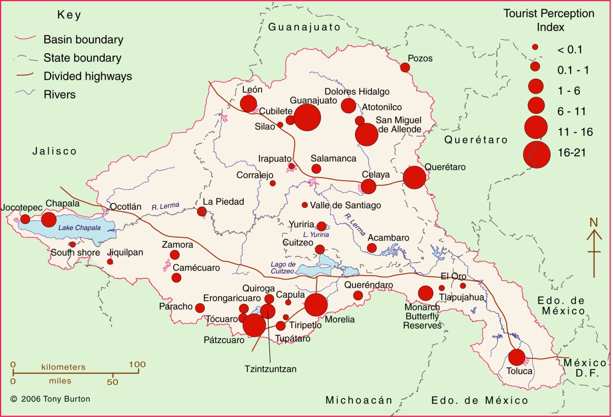
The Lerma-Chapala Basin (see map) is one of Mexico’s major river systems, comprising portions of 127 municipalities in five states: México, Querétaro, Michoacán, Guanajuato and Jalisco. The basin has considerable economic importance. It occupies only 2.9% of Mexico’s total landmass, but is home to 9.3% of Mexico’s total population, and its economic activities account for 11.5% of national GDP. It also has considerable importance for tourism.

Lerma Basin Tourist Perception Index.

Lerma Basin Tourist Perception Index. Cartography: Tony Burton / Geo-Mexico; all rights reserved Click to enlarge.

The red circles superimposed on the map represent an index of tourism perception. This index is based on an analysis of seven tourist guides that purport to cover the entire country:

  • AAA Tourbook (2004)
  • Let’s Go Mexico (2004)
  • Lonely Planet (2002)
  • Footprint Guide (1999)
  • Upclose Mexico (1998)
  • Insight Guide (1994)
  • Cadogan Guide (1991)

In each case, the total number of lines of text in the guide devoted to any location within the Lerma-Chapala drainage basin was counted, as well as the number of lines devoted to each individual location. This allowed a ratio or percentage to be worked out for each place for each book. For example, if a book had 240 lines in total devoted to the drainage basin, of which 60 were devoted to San Miguel de Allende, the perception index for San Miguel for that book would be 60/240 * 100 = 25%. Similar calculations were performed for all the locations mentioned, for each book, and then the mean index was calculated for each location. These mean indices were the basis for the size of the circles on the map.

In broad terms, the map shows which places are likely to be on a foreign traveler’s radar when they are visiting the area. Those familiar with this area may be surprised to see that the ghost town of Pozos merits as many lines of text as Quiroga (and indeed more lines of text than Atotonilco). Another surprise is that Tzintzuntzan appears to be as much in the tourist eye as Chapala, Dolores Hidalgo or Toluca. The main purpose of this post is not to analyse such apparent anomalies but only to suggest a relatively easy way of analysing tourist perceptions through the use of tourist-oriented literature. Applying the same method to the entire country, on a state-by-state basis, throws up far more interesting anomalies which we plan to share at some point in the future.

Related posts:

Related posts:
Recent progress in waste water treatment in Mexico

 Mexico's geography in the Press  Comments Off on Recent progress in waste water treatment in Mexico
Aug 252014
 

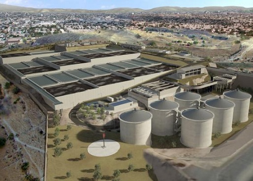
Two wastewater treatment plants have been in the news recently. The first is the $230 million Agua Prieta wastewater treatment plant, located north of Guadalajara in Jalisco, which was formally inaugurated last month. It is the first stage in a plan to restore the heavily polluted Santiago River back to health. The Santiago is the outflow from Lake Chapala and receives pollutants from the industrial zone of El Salto outside Guadalajara. The initial capacity of the Agua Prieta plant is 6,500 liters/second, almost all of which is returned to the river after treatment.

The plant was built by a consortium led by ICA subsidiary Conoisa, Atlatec, and Servicios de Agua Trident under a 20-year concession. President Enrique Peña Nieto claims on his government webpage that, “Integrated, sustainable water management is a government priority. The challenge is even greater because almost 50% of the wastewater returned to the environment does not undergo any form of treatment… The Agua Prieta Wastewater Treatment Plant in Zapopan… [will] improve the quality of life of 3.3 million inhabitants in the metropolitan area of Guadalajara… It will treat 82% of the wastewater in the area, and 100% when the complementary sewage works are completed.”

agua-prieta-wastewater-According to government figures, waste water treatment coverage at the national level is currently 50.3%, with a 2018 target of 63%. Agua Prieta has raised national coverage to 53.3%, and will boost it to 54.3% once the plant is operating at full capacity and treating 8,500 liters/second of wastewater. At the state level, Jalisco is now treating 32% of its wastewater.

The Agua Prieta plant is currently the largest of its kind in Mexico and is powered by biogas derived from the wastewater sludge. However, an even larger plant is under construction, in the state of Hidalgo in central Mexico. The Atotonilco Wastewater Treatment Plant is being built by a consortium, including Mexican construction companies ICA and IDEAL, Mitsui subsidiary Atlatec and Spanish firm Acciona Agua, that won the concession to design, build, and operate this plant for 22 years, at which point the plant will be transferred to federal ownership. Work began in 2010 and is due to be completed by 2015.

The Atotonilco Wastewater Treatment Plant will be the largest wastewater plant in Latin America and one of the largest in the world, with a biological treatment capacity of 23,000 liters/second (1.99 million m3/day). The wastewater treatment is performed by a series of conventional processes, with an additional chemical process during the rainy season. Treated waters from this plant are already being used in agriculture without any additional cleaning steps. The plant is self-sufficient in terms of energy usage, since it converts the methane offgas from the wastewater sludge into electrical energy.

Related posts:
Aug 162014
 

Tourism associated with rivers and lakes

So far as tourism is concerned, Lake Chapala is far more important than the other bodies of water within the basin. Only limited recreational activities are practiced in the various man-made reservoirs and in lakes Yuriria and Cuitzeo. Tourism is locally important in Zirahuén the most pristine of the basins lakes, but its small area restricts development prospects. Tourism, including ecotourism, is also locally important in Lake Pátzcuaro, with pronounced seasonal peaks corresponding to school vacations and the annual Night of the Dead. Surprisingly, there are no specialized ecotourism services at Lake Chapala.

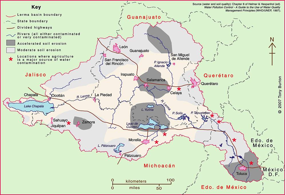
Lerma-Chapala Basin

Lerma-Chapala Basin. Cartography: Tony Burton/Geo-Mexico; all rights reserved

The map shows areas of soil degradation in the Lerma-Chapala basin, as well as the locations where agriculture is a major source of water contamination. The environmental impacts of tourism in the basin are concentrated in the major cities such as Guanajuato, San Miguel de Allende and León, as well as in the smaller communities where tourism is of particular importance, such as Chapala and Pátzcuaro.

The lakes in the basin, especially Chapala, have always had more significance than the rivers for recreation and tourism activities. In the nineteenth century, sail canoes plied the waters of Lake Chapala. Fluctuating lake levels since the 1950s have prevented any concerted effort to establish modern water sports (yachting, water-skiing, windsurfing) on the lake, though casual users can be seen sporadically, mainly at weekends and during school holidays. Recreational fishing is virtually non-existent in the basin. Boatmen and fishermen often have conflicting demands.

Potential for ecotourism

Environmental degradation throughout the basin has reduced the number of potential ecotourism locations. The few remaining natural habitats are in urgent need of effective conservation. None of the few small areas of the basin currently protected at a federal level is associated directly with the River Lerma or Lake Chapala. Several tourism hot spots are under extreme pressure, operating at close to carrying capacity (defined as the maximum number of visitors they can handle without adverse environmental impacts). They include the Monarch butterfly reserves, Lake Camécuaro National Park, and the island of Janitzio in Lake Pátzcuaro. Well managed tourism could help finance habitat restoration and protection. Successful planning will require considerable local participation.

Lovers of flora and fauna want to see native and endemic species, rather than imported exotics. Bird-watching is one of the fastest growing recreational activities in the U.S., a huge niche tourism market in a wildlife watching industry worth 10 billion dollars in North America (Stap, 2002). In the basin, bird-watchers have the opportunity to see several endemics, as well as spectacular flocks of the White Pelican (Pelecanus erythrorhynchos), which can be better viewed on the relatively undeveloped southern shore of Lake Chapala than in its breeding grounds far to the north.

The development of horse-back riding, hiking and walking trails holds considerable potential for the future. Niche markets, such as cultural, shopping and eco-tours could all be further developed. Most tourists prefer a mix of experiences; the basin offers numerous, varied tourism possibilities.

Historically, hunting was an important activity in certain areas, particularly in the marshes at the eastern end of Lake Chapala (the ciénega). One ecological issue here, aside from any need to manage wildlife numbers, is the gradual decomposition of the lead-rich cartridges used a century ago. While this needs further study, this is gradually leaching lead into the environment, but is not the only source of the elevated levels of lead that have been reported in fish and lirio samples (Jay & Ford in Hansen & Van Afferden, 127). Careful monitoring is needed to ensure that no health risk is posed to humans.

Tourism exacerbates existing demands for limited supplies of water. This needs to be recognized in tourist-oriented cities such as San Miguel de Allende, Guanajuato and Pátzcuaro. Some recreational and tourism developments are more water demanding than others. Large expanses of grass cause high losses of water through evapo-transpiration especially during the dry season when watering is needed if grass is to be kept green. However, in the rainy season, grass promotes higher infiltration rates, enhancing groundwater recharge. Pressure from public and private gardens for water could be significantly reduced by xeriscaping.

Management is also needed to ensure that chemicals used in gardens, hotel grounds, and hotels do not cause pollution. The misuse of fertilizers and pesticides can have serious deleterious environmental effects. Overfertilization, for example, can increase nitrogen and phosphorus loads on watercourses, promoting eutrophication.

Golf can be one of the least environmentally sound of all recreational activities (Elkington & Hailes 1992). Constructing a golf course may involve habitat destruction and loss of wildlife; its maintenance may require copious quantities of water and agro-chemicals. A single course may use 330,000 cubic meters of water a year, as much as 4,500 people (Walsh, 2004) Aside from the ethical issue of whether water should be allocated to the playgrounds of the rich while the poor go without, golf courses can greatly reduce water consumption with careful design and management. Of Mexico’s 200+ golf courses, at least 23 are located in the basin. Several were built in the past twenty years. Several others are still in the planning stages. More golf courses may attract more retirees and tourists, but decision makers need to consider the possible social and environmental effects of constructing more courses.

References:

  • Hansen, Anne M. & van Afferden, Manfred (ed). The Lerma-Lake Chapala Watershed: Evaluation and Management. New York: Kluwer Academic / Plenum Publishers. 2001.
  • Elkington, John & Julia Hailes. Holidays that don’t cost the earth. The guide to greener holidays. London: Victor Gollancz Ltd. 1992.
  • Stap, Don. “Great Florida Birding Trail” in Audubon Magazine September, 2002.
  • Walsh, J. “War over water”. Golf Course News, October 2004. G.I.Media. 2004

Source:

This post is based on my contribution (on tourism) to the Atlas de la cuenca Lerma-Chapala, construyendo una visión conjunta, published by Semarnat-UNAM-IE, Mexico, in 2006. (The link is to a low-resolution pdf of the entire atlas).

Related posts:
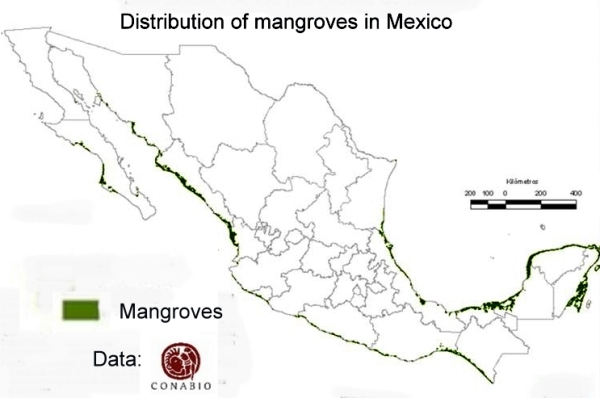
Where are Mexico’s mangrove swamps?

 Updates to Geo-Mexico  Comments Off on Where are Mexico’s mangrove swamps?
Aug 142014
 

The National Commission for the Knowledge and Use of Biodiversity (Comisión Nacional para el Conocimiento y Uso de la Biodiversidad, CONABIO), has identified 81 distinct areas in Mexico that have mangroves with “biological significance and in need of varying degrees of ecological rehabilitation” (see summary map). These regions are distributed as follows:

  • 10 on the northern Pacific Coast
  • 6 on the central Pacific Coast
  • 13 on the southern Pacific Coast
  • 27 on the Gulf of Mexico and
  • 25 on the Yucatán Peninsula.

A national inventory has now been compiled by CONABIO. All areas have been surveyed and preliminary descriptions published including details of their location, size, physical characteristics, socioeconomic conditions, local uses of mangrove, biological details, including vegetation structure, and an assessment of local impacts and risks, management and existing conservation measures.

Map of distribution of mangroves in MexicoThe areas of mangroves have been mapped at a scale of 1:50,000 and satellite photos from 2005-2006 have been used in conjunction with fieldwork to calculate the areas of mangroves. The final map is believed to be more than 90% accurate, a reasonable baseline for future comparisons. CONABIO is planning to resurvey the mangrove areas every 5 years following the same methodology.

According to preliminary comparisons with previous attempts to quantify the extent of mangroves in Mexico (the subject of a future post), the loss of mangroves was greatest in the period 1970-1980, and in 2000-2005, but then diminished in the period 2005-2010.

Between 2005 and 2010, the states where mangrove loss remained high (as a percentage of the total area of mangroves in the state) included Chiapas, Baja Californa Sur and Sonora. However, the states losing the largest areas of mangroves in absolute terms were Quintana Roo, Campeche and Nayarit. Jalisco has the unfortunate distinction of being the state where coastal mangrove loss was highest (in terms of the proportion of its total coastline length bordered by mangroves).

Related posts:
Day trips and tourism in the Lerma-Chapala basin

 Other  Comments Off on Day trips and tourism in the Lerma-Chapala basin
Aug 072014
 

An earlier post looked at the significant impacts of the estimated 10,000 to 15,000 residential tourists (non-working, non-Mexicans) living part or full-time in the Lerma-Chapala basin. These residential tourists are concentrated in San Miguel de Allende and in the Chapala-Ajijic area on Lake Chapala:

Day trips and regular tourism are also important activities in the Lerma-Chapala basin. Both day trippers and tourists bring economic, social, cultural and environmental benefits, but may also create adverse impacts. Conflicts between tourism and other activities are increasing as demographic and environmental pressures rise.

Day trips

By definition, day trips last less than 24 hours. Most day trips are to a single destination, usually only a relatively short distance from home. Within the Lerma-Chapala basin, certain day trip flows stand out. The strong flow of day-trippers from Guadalajara to Chapala-Ajijic peaks on Saturdays, Sundays and public holidays. Day trippers account for about two-thirds of the total number of visitors to Chapala-Ajijic. Day trip flows linking San Miguel de Allende, Dolores Hidalgo and Guanajuato, and between Morelia and Pátzcuaro are also important. Elsewhere, the Monarch butterfly reserves have seasonal importance as day trip destinations; for example, El Rosario, the most visited reserve, attracts up to 5,000 visitors a day between early December and late March.

Tourism

Tourism, on the other hand, involves overnight stays. A typical tourist trip lasts between 3 and 8 days. Tourism may involve multiple destinations, further away from home. In Mexico, national tourists are more numerous, but, on average, earn less, spend less, and stay a shorter time, than international tourists.

In the Lerma-Chapala basin, tourism began to flourish at the end of the nineteenth century, alongside improvements in transportation, especially the building of railways. The shores of Lake Chapala were an early magnet for the wealthy. Developers redesigned the unplanned fishing villages, attracting visitors from all over Mexico. Even today, the Chapala landscape reflects the historical and cultural influences which have influenced it.

Other parts of the basin also became important tourist destinations. The colonial cities route, taking in San Miguel de Allende, Guanajuato, Morelia, Pátzcuaro and Querétaro, is a prime example, which has been very successfully marketed.

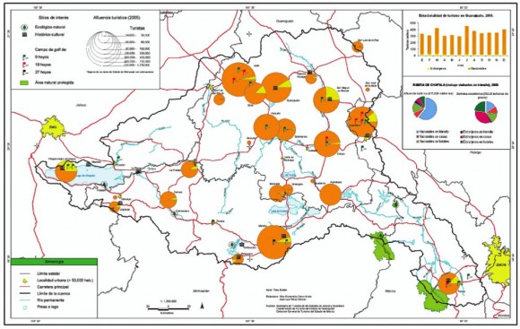
Quantifying tourism in the basin is difficult. Official tourism statistics are based on surveys, but these data have their limitations. The size of the circles on the map below represents the total number of tourists visiting each location in 2005, according to Tourism Secretariat figures. The yellow segment represents the percentage of tourists that are international. atlas-tourist-numbers-2The map shows that tourism is heavily concentrated at a small number of locations close to the boundary of the basin: Morelia, Toluca, Querétaro, San Miguel de Allende, Guanajuato and Chapala-Ajijic. Foreign tourists are particularly important in Toluca, San Miguel de Allende and Chapala-Ajijic. The precise numbers should be treated with caution. Many tourists visiting San Miguel and Chapala-Ajijic (but not Toluca) do not stay in hotels but in “Bed and Breakfasts” or with friends or relatives.

Tourism planning needs to consider strategies which:

  • preserve existing and potential natural attractions and historic sites.
  • increase the number and variety of locations visited by tourists.
  • reduce the pronounced seasonality of existing tourism.
  • increase the average length of stay and expenditure of tourists.

Source:

This post is based on my contribution (on tourism) to the Atlas de la cuenca Lerma-Chapala, construyendo una visión conjunta, published by Semarnat-UNAM-IE, Mexico, in 2006. (The link is to a low-resolution pdf of the entire atlas).

Related posts:
Back to the drawing board for US-Chinese tourism project near Cabo Pulmo

 Mexico's geography in the Press  Comments Off on Back to the drawing board for US-Chinese tourism project near Cabo Pulmo
Jun 232014
 

Good news for Cabo Pulmo, the marine park in Baja California Sur! Cabo Pulmo is a 7,111-hectare (17,550-acre) marine reserve that boasts the best-preserved coral reef in Mexico’s Pacific region. The proposed tourist megaproject known as Cabo Dorado on the edge of the park has been shelved, at least for now.

The US-Chinese joint venture behind Cabo Dorado said it is halting plans to build the tourist development due to the “well-founded” criticism of environmental groups. [See New threat to Cabo Pulmo National Marine Park] The $3.6 billion project was to have included construction of thousands of hotel guestrooms in the area where another giant development project, Cabo Cortés, had been planned. The Cabo Cortés project was cancelled by government officials on the grounds of environmental concerns.

The firms behind Cabo Dorado are Glorious Earth Group (USA) and Beijing Sansong International Trade Group (China), together with China State Construction Engineering Corporation. The initial proposal was for a project involving the construction of a new “ecotourist city” on 3770 hectares (9317 acres) of land, including 6,141 homes,9 hotels, 2 golf courses, a landing strip, shops and a convention center.

The group has now halted its initial environmental-impact study of the Cabo Dorado project, with the intention of resuming this procedure in the near future with a new project “that meticulously takes into account the well-founded criticisms that have been expressed and which we’ve listened to carefully and with the utmost respect”.

Related posts:
Medical tourism and the medical equipment industry in Mexico

 Other  Comments Off on Medical tourism and the medical equipment industry in Mexico
Jun 212014
 

Mexico is both a growing market for medical tourism and a world leader for the manufacture of medical equipment.

Growing market for medical tourism

The global market for medical tourism in 2013 was estimated to be worth about $2.847 billion, with some 7 million patients seeking medical treatment outside their home country each year. According to Patients without Borders, a U.S. business that specializes in the field, Mexico is currently the second most popular destination for medical tourists, after Thailand. Nationwide, Mexico has more than 71,000 doctors working in hospitals and private clinics. Almost two-thirds of all doctors in Mexico are specialists, compared to an average of 57.7% for all OECD member nations.

Mexico’s Economy Secretariat estimates that, combined, the one million medical tourists in 2013 and the numerous affiliated services such as spas, massages and non-conventional therapies, contributed $4.2 billion to the national economy. This figure is growing at about 7% a year.

Patients without Borders claims that patients from the USA and Canada pay between 36 and 80% less for operations and medical treatments in Mexico than the cost in their home country. The most important states for medical tourism are Nuevo León, Baja California, Baja California Sur, Sonora, Tamaulipas, Chihuahua, Jalisco, Quintana Roo and Yucatán.

A plan to build a new “medical city” has been announced by health officials in Quintana Roo. It would be called “Jardines de la Sabiduría” (Gardens of Wisdom) and located on a 550-hectare lot between Cancún and Puerto Morelos. The new city would have four zones: residential, hospitals, recreation and cultural/educational, and would include at least four hospitals: for children, cancer care, dental work and orthopedic surgeries respectively. It remains to be seen if sufficient foreign investment can be found to bring this project to fruition.

World leader for medical equipment

Mexico is a major manufacturer of medical devices. Sales of Mexican-made medical equipment exceed $10.6 billion a year and are predicted to reach $14.9 billion by 2020. Manufacturing costs for medical devices in Mexico average 25% below those in the USA, the world’s largest market for such products.

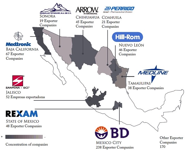
Major medical device manufacturing areas in Mexico

Major medical device manufacturing areas in Mexico. Credit: Economy Secretariat.

Mexico’s exports of medical equipment and supplies were worth $6.2 billion in 2011, making Mexico by far the largest exporter of medical devices in Latin America, and the 11th largest in the world. 92 % of medical devices manufactured in Mexico are exported to the USA, accounting for two-thirds of all U.S. imports of those products.

According to Pro-Mexico, Mexico is the world’s largest exporter of bore needles; the 4th largest exporter of medical, surgical, dental and veterinary furniture; the 5th largest exporter worldwide of medical,surgical, dental and veterinary instruments and apparatus; and the 7th largest exporter worldwide of ozone therapy, oxygen therapy, aerosol therapy apparatus, breathing apparatus and other respiratory therapy apparatus.

More than 2,000 separate businesses, and about 135,000 workers help invent, design and manufacture medical devices in Mexico. Medical device manufacturing is concentrated mainly in northern border states, especially Baja California, where the cluster of more than 60 specialist firms includes Smiths, Tyco Healthcare, Cardinal Health, Medtronic, Gambro, ICU Medical, CLP, Sunrise Medical and North Safety Products.

Data:

  • The Medical Device Industry, 2012 (Pro-Mexico; pdf file)

Related posts:

Common errors of Mexican geography #2: confusing the Sierra Madre with the Volcanic Axis

 Other  Comments Off on Common errors of Mexican geography #2: confusing the Sierra Madre with the Volcanic Axis
Jun 192014
 

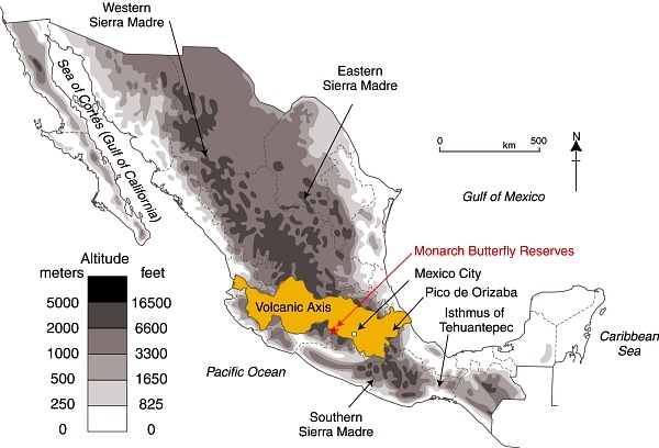
Describing somewhere in Mexico as being “located in the Sierra Madre mountains” may conjure up images of high, possibly snow-capped peaks and rugged scenery, but does very little to pin down the location. Mexico has several Sierras Madre (literal translation: Mother Ranges). The three main Sierra Madre regions in Mexico are the Western Sierra Madre, Eastern Sierra Madre and Southern Sierra Madre (see map).

The Western Sierra Madre (Sierra Madre Occidental) is the youngest, highest and most viciously dissected of the three. This region includes the scenically amazing Copper Canyon region we have described in many previous posts, including:

Location of Volcanic Axis and Monarch Butterfly reserves

Location of Volcanic Axis and Monarch Butterfly reserves. Basemap: Figure 3.1 of Geo-Mexico; all rights reserved.

The Western Sierra Madre extends only as far south as the states of Nayarit and Jalisco.

Its counterpart on the eastern side of the country is the Eastern Sierra Madre (Sierra Madre Oriental) which is older, lower and less rugged. Between these two major mountain ranges are mid-elevation basins and plains.

At the southern end of both the Western Sierra Madre and the Eastern Sierra Madre is the Volcanic Axis.

The Southern Sierra Madre (Sierra Madre del Sur) lies south of the Volcanic Axis, largely in the state of Oaxaca.

The details of Mexico’s physiographic regions are complex, but the basic relief pattern of these three Sierra Madre regions, separated by the Volcanic Axis and mid-elevation basins and plains, is fairly simple. It is therefore disappointing when we read references to the Sierra Madre regions that are geographically inaccurate.

The Monarch Butterfly reserves, for instance, are regularly described as being in the Sierra Madre, or the Western Sierra Madre, even though they are located hundreds of kilometers away from the Western Sierra Madre, on the southern edge of the Volcanic Axis (see map). In the original National Geographic article about the “discovery” of the Monarch Butterflies’ overwintering sites (August 1976), the location of the butterflies was deliberately left vague (to prevent human-induced disruption of the sites), so that article can readily be excused for mislocating the sites as being in “Mexico’s Sierra Madre”. (The tiny map that accompanied that article also shifted the Monarch’s wintering areas well away from their real position.)

Despite the efforts of the National Geographic, it was not long before journalists published articles giving the precise locations of the sites, and visitors started to flock to see this marvel of nature. The establishment of reserves has now brought a measure of sanity and control to access and most visitors now behave respectfully.

One of the latest in the long line of journals and magazines to erroneously refer to the site of the Monarch reserves as “in the remote Sierra Madre mountains” (but lacking the original excuse of the National Geographic) is the Canadian Geographic in its December 2013 Annual Wildlife Issue. The general tone of the article is helpful, and it rightly emphasizes the need to protect habitat along the entire migration route between Canada and Mexico, so why mar the overall quality by making such a basic error of Mexican geography? Let’s help educate readers by making it clear that the Monarch Butterfly reserves are not in any Sierra Madre, but are in the Volcanic Axis!

Monitoring air pollution in Guadalajara

 Books and resources, Teaching ideas  Comments Off on Monitoring air pollution in Guadalajara
Jun 162014
 

Air pollution in the city of Guadalajara, the state capital of Jalisco, has worsened over the past decade, though there are some recent signs of improvement :

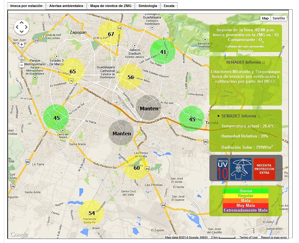
The Jalisco Environmental Agency now has a webpage where residents and travelers alike can now monitor Guadalajara’s air quality on an hourly basis. Readings for 10 stations are superimposed on a basemap on that page, together with links to graphs showing recent trends and other meteorological data. Tabs above the map also give a link to the current wind conditions across the city. Historical data (in Spanish) can also be accessed via the link to “Datos”.

Screenshot of Guadalajara air monitoring webpage

Screenshot of Guadalajara air monitoring webpage. Note: Two stations are shown as undergoing maintenance.

The map provides summary data in IMECAs, which stands for Índice Metropolitano de la Calidad del Aire (Metropolitan Index of Air Quality). IMECAs are a compound index combining measurements of concentrations of ozone (O3), sulphur dioxide (SO2), nitrogen dioxide (NO2), carbon monoxide (CO) and particles smaller than 10 micrometers (PM10).

In Guadalajara, formal smog alerts are issued if average readings rise above 150 IMECAs (“Very Bad”) for more than two consecutive hours. If readings rise above 200 IMECAs (“Extremely Bad”), then “serious alerts” impose restrictions on vehicle use and may lead to the suspension of school classes.

In Guadalajara, the worst air quality tends to be in the southern and eastern sections of the city. It also tends to occur in the months of April and May, immediately before the rainy season gets underway. The webpage system gives everyone an easy way to check these assertions!

In Guadalajara, mitigation efforts are centered mainly on reducing vehicle emissions (partly by stricter emissions testing and verification, and partly by improvements to the public transport network) since they are the main source of pollution. To date, there are no plans in Guadalajara to introduce a “Day without car” program similar to that in Mexico City:

Teaching idea

Use the Jalisco Environment Agency webpage to monitor Guadalajara’s air pollution and identify any patterns or trends related to air pollution in the city. Consider suggesting one or more hypotheses, such as “Air pollution gets worse in the afternoon”, or “The level of air pollution in eastern Guadalajara is worse than in western Guadalajara”, before testing your ideas using the online data.

Related posts:

Jun 022014
 

This engaging book analyses the historical geography of the port of San Blas, on Mexico’s west coast, and its hinterland which includes the small city of Tepic, the state capital of Nayarit. This area held immense importance during colonial times, was one of the main gateways for trade and influence peddling during the nineteenth century, before lapsing into relative obscurity at the end of the that century, and into the twentieth century. The tourism industry has sparked a mini-revival but none of the many grandiose plans for this coast have even been brought fully to fruition.

richter-coverThe Camino Real in Richter’s title is actually a branch from the Camino Real de Tierra Adentro (The Inland Royal Road, the spine of the colonial road system in New Spain). During colonial times, this linked the inland city of Guadalajara to Tepic and thence San Blas, though the modern highways uniting these places no longer follow the same route.

Robert Richter has known this area personally for decades, and his intimate knowledge of the local geography shines through. The book combines his own personal experiences with intensive historical research, both in the library and on the ground. Richter’s objective is to pin down the precise route of the Camino Real, and then find every remaining vestige of it that he can on the ground.

In reading the story of San Blas and the Camino Real, readers are treated to a dazzling array of insights into what made this area tick for so long before subsiding into something of a backwater. This branch of the Camino Real, from Guadalajara to San Blas, played a key role in the history of Western Mexico, and saw everything from pirates and adventurers to soldiers, priests and smugglers.

As Richter points out, “The Matanchen Bay-San Blas region grew in geographic and strategic importance to become the most important Pacific seaport between Guayaquil, Ecuador, and San Francisco, California, in the 1830s, a major international way station for both legal and contraband trade between an ungovernable Mexico and the rest of the world.”

This growth continued and, “In the 1850s, the cultural, economic, and political events roiling all along the Camino Real from San Blas to Guadalajara, especially in the mild sierra valley surrounding the city of Tepic, spawned a new regional identity, and eventually, a new political entity—the Mexican state of Nayarit.”

Richter tells his story with passion and it is impossible not to be drawn into the narrative and share his excitement as he sets out to find “missing” sections of the Camino Real, accompanied by a motley crew of secondary characters. To what extend does he succeed? Sorry, no spoilers here!

Inevitably, the past merges with the present and the future. What began as a seemingly straightforward historical geography becomes at turns a travelogue, journal of fieldwork and short essay about the sustainability of economic development along this coast. Richter is clearly not against change, but argues strongly that local tourist development in the future must take account and respect the region’s ecology, its history and its culture.

As the back cover blurb aptly states, “To explore Nayarit’s wild and gorgeous geography, trying to site the ancient Camino Real, is to stumble over another road running toward the state’s future economic development as part of the Mexican Riviera.”

This book should be of interest to geographers everywhere. It serves to prove that historical geography need not be dull and stuffy but can be made relevant, exciting and even entertaining, at the same time as it offers us valuable insights into possible futures.

One minor plea: please add an index when the second edition of this book is prepared!

Search for the Camino Real, a history of San Bad and the road to get there” is one of several books by Richter centered on the fading coastal village culture of Nayarit and the Mexican Riviera. His adventure novel, “Something like a Dream” (Oak Tree Press, 2014) is an especially entertaining read, with a lively plot and well-described settings ranging from the tourist resort of Puerto Vallarta to Nayarit fishing villages and tiny Huichol Indian settlements high in the Western Sierra Madre.

Map of the beaches of Colima, Jalisco and Nayarit, Mexico shows the location of all the key places mentioned in Richter’s books.

Related posts:

May 092014
 

We have repeatedly questioned the long-term wisdom of large-scale tourist developments along Mexico’s coastline. See, for example:

The good news, in June 2012, was that it looked as if the conflict at Cabo Pulmo, in Baja California Sur, had been resolved in favor of protecting the environment:

Unfortunately, land developers won’t take “No” for an answer. Immediately after its “cancellation”, the Cabo Cortés project was renamed Los Pericúes and relaunched, with few if any differences from the original version. Two years on, the project has been taken over by a new consortium of developers and renamed “Cabo Dorado”. Some changes have been made along the way, and Cabo Dorado no longer includes a marina or desalination plant, and its plans appear to have a lower building density.

There are still some legitimate concerns about the long-term impact of such a project in this area, so kudos to Carolina Herrera (Latin America Advocate of the Natural Resources Defense Council in Washington DC) for her impassioned plea calling for Cabo Pulmo to be protected from the latest incarnation of this long-proposed tourist megaproject.

The project is located immediately north of the Cabo Pulmo Marine Park, which over its 19 year lifespan has proven to be hugely successful in conservation terms (The extraordinary ecological recovery of Mexico’s Cabo Pulmo Marine Park), while providing local people with the opportunity to offer a variety of alternative forms of low impact tourism. The site of the Cabo Dorado project site is home to 26 “at risk” species, including endemic plants and endangered sea turtles.

Cabo Dorado is a 3.6-bilion-dollar joint investment by La Rivera Desarrollos BCS, a joint venture of Glorious Earth Group (USA) and Beijing Sansong International Trade Group (China), together with China State Construction Engineering Corporation.

The project is for the construction of a new “ecotourist city” on 3770 hectares (9317 acres) of land. Slightly more than two-thirds of this area will be retained as a “conservation reserve”.

The master plan for the developed third includes:

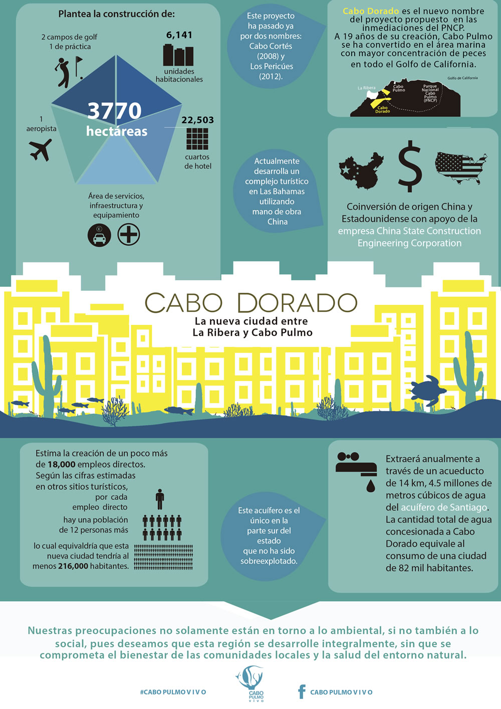
  • 6,141 homes  (443 ha)
  • 9 hotels with 4,080 hotel rooms (721 ha) [the 22,503 number on the infographic below is an error]
  • 2 golf courses and practice ground (162 ha)
  • Services, infrastructure, maintenance (334 ha)
  • 1 landing strip
  • 1 14-km aqueduct
  • Shops, convention center, etc
Infographic from www.cabopulmovivo.org

Infographic from www.cabopulmovivo.org   Click to enlarge

According to the developers. Cabo Dorado “will be a fully integrated development, a first of its kind in the country, as it combines educational, recreational activities, scientific research, health promotional centers and a strong commitment to preserve the environment.” To this end, the project includes “an interpretation center, a technological and biological research center for studies related to the Sea of Cortes and the Desert of Baja California Sur, as well as a cultural exchange center, an educational institute and a student campus. In addition, there will be centers dedicated to the promotion of trade and investments, a high performance sports center, 9 world-class hotels and residences for temporary visitors and full time residents.”

Cabo Dorado will extract up to 4.8 million cubic meters of water a year from Santiago aquifer, roughly equivalent to the water needs of a city of 82,000 people) and will generate 711,900 kilograms of waste per day.

On the positive side, the project will create 18,000 direct and indirect jobs and bring around 900 million dollars/year into this area. It does not involve a marina or pumping wastewater into the sea which should prevent direct adverse ecological impact on marine life. The masterplan includes a “support town” for workers, which means that the local municipality does not need to build additional infrastructure to support the project.

The Mexican Center for Environmental Law (CEMDA) has called for a formal public meeting and consultation to ensure people are adequately informed about the latest plans and the potential social and environmental impacts.

Further reading:

For an exceptionally informative series of papers (in Spanish) on all aspects of tourism and sustainability in Cabo Pulmo, see Tourism and sustainability in Cabo Pulmo, published in 2008 (large pdf file).

Related posts:

Apr 182014
 

A major earthquake struck southern Mexico at 7:27 local time on Friday 18 April 2014. The effects of the earthquake, which had its epicenter in Guerrero, were felt at least as far away as Mexico City. Authorities in the states affected, which include Guerrero, Morelos, México, Puebla, Oaxaca, Querétaro, Veracruz, Jalisco, Michoacán, Tlaxcala, Guanajuato, Hidalgo, Colima and the Federal District, have reported only minor damage, and no loss of life.

The preliminary report from Mexico’s National Seismological Institute says that the earthquake had a magnitude of 7.0, with an epicenter 31 kilometers northwest of Tecpan in Guerrero, and occurred at 7:27 a.m. local time. The earthquake occurred at a depth of 10 kilometers.

Initial reports from the U.S. Geological Survey (including a map) are that the earthquake was 7.5 magnitude, and at a depth of around 48 kilometers (30 miles). The USGS has since downgraded the magnitude to 7.2.

First hand reports from Mexico City say that power went off in several areas in the north of the city, and that cell phone communications were also down in some areas. The Federal Electricity Commission reported 6 hours after the earthquake that power had been restored to 98% of the 1.2 million people affected in the Mexico City Metropolitan Area. Some windows have been shattered, and there are a handful of reports of minor structural damage, including 15 walls that collapsed and 48 buildings that suffered some damage. The city was quieter than normal because of the Easter holidays, during which many city dwellers take vacations at the beach.

The most serious damage in Mexico City appears to have been in the Morelos residential complex in colonia Doctores, where the residents of two of the 14-story buildings have apparently been evacuated following reports of cracks in walls and passageways, and the separation of some stairways. Following a formal building inspection, one of the buildings will not be reoccupied prior to remedial work being carried out.

Residents of Mexico City received 65 seconds warning via Mexico’s advanced Seismic Alert system (Sistema de Alerta Sísmica), which functioned precisely as it was designed to. There were more than twenty aftershocks in the five hours after the initial earthquake, the largest of which was magnitude 4.8.

George Dunn in Puerto Vallarta (see comments) reports that buildings at the Bay View Grand were evacuated. “but all is well”. Many tourists in Puerto Vallarta and Acapulco left their hotel rooms temporarily during the quake which lasted about one minute.

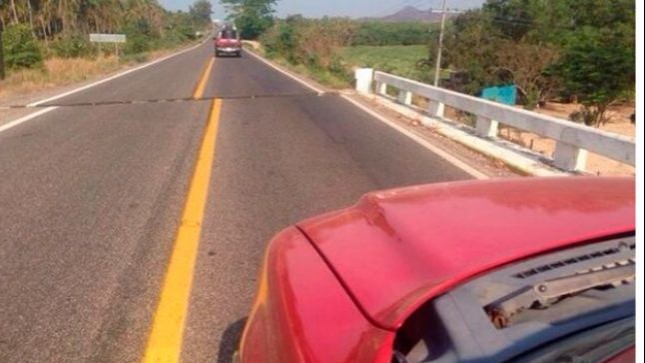
In Guerrero, it is reported that the highway between Acapulco and Ixtapa-Zihuatanejo is temporarily closed to traffic while inspections are carried out of a bridge near Tecpan, where the road shows a marked displacement (see image), and the rubble from several small landslides is removed. [Update: 9 May 2014: A second earthquake of magnitude 6.4 on 8 May has caused the bridge to collapse completely. The bridge, known as “El Cuajilote” is located at km 111 of the federal highway between Acapulco and Zihuatanejo.]

road-fracture

Later on Friday, officials of Guerrero state acknowledged that many public buildings in the state suffered damage from the earthquake. In Petatlán, near the epicenter, at least 100 homes were damaged. In the state capital of Chilpancingo, several walls collapsed, at least three homes and the tower of the Santa María de la Asunción cathedral suffered some damage.

As a precaution, the main (tourist) dock in Zihuatanejo has been closed, pending a formal inspection, but is expected to be back in operation within the next day or two.

Curious coincidence: The earthquake came exactly 108 years to the day after the Great San Francisco Earthquake of 1906.

We will continue to update this post periodically over the next few days to reflect any significant changes.

Related posts:

The diary of a food activist’s visits to Mexico

 Books and resources  Comments Off on The diary of a food activist’s visits to Mexico
Apr 142014
 

Food activist Jill Richardson, author of Recipe for America: Why Our Food System is Broken and What We Can Do to Fix It, has a blog called Jill Over the Ground (formerly La Vida Locavore – Locavores being people interested in eating food that is locally produced, and has not traveled long distances.)

Richardson, who serves on the policy advisory board of the Organic Consumers Association, visited Mexico twice in 2010 and has published an interesting online diary of her trips. Richardson visited the two contrasting states of Jalisco and Chiapas. In the former wealthy state, she was able to spend some time in the agricultural community of Cuquio. Her purpose on this trip was “to learn about the impacts of the Green Revolution and NAFTA on corn production there.” Later in the year she visited Chiapas, a far less wealthy state, during the time of the coffee and corn harvests, “working with and learning about the Zapatistas (an indigenous insurgent group).”

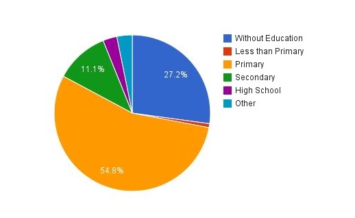
Educational level of farmers in Mexico, 2007

Educational level of farmers in Mexico, 2007. Credit: LaVidaLocavore.com

Following her trips, Richardson compiled a page summarizing agricultural statistics for Chiapas, Jalisco and Cuquio, based on Mexico’s 2007 Agricultural Census. The page has numerous tables and graphs about everything from crops grown and machinery used to irrigation, access to insurance, living conditions and other sources of household income.

Agriculture in Cuquio, 2010

Agriculture in Cuquio, 2007. Credit: LaVidaLocovore.com

Richardson’s passion for produce that is organic and locally produced is admirable. The anecdotes in her diary entries are well told, and raise important issues about the overuse/abuse of pesticides and fertilizers,the exploitation of farmers, microlending and a host of other factors that caught her attention. While her diaries are certainly not a comprehensive analysis of agriculture in the areas she visited, they do shed some light on some of the important issues facing farmers there. The diary entries are worth reading for the many examples and photographs included.

Her diary entries include:

I should note that despite Richardson’s impassioned and persuasive writing, I’m not actually in agreement with her advocacy for locavorism. I find myself more in agreement with the reviewer of her book who wrote that, “The author’s rabid advocacy of locavorism is especially myopic; she brushes past the costliness and impracticality—When buying eggs I ask the farmer how many chickens they own and if these chickens are on pasture—and ignores critics who argue that locavorism is an energy-inefficient fad.” (See The energy efficiency of farming in Mexico and elsewhere.)

That said, Richardson’s online diary is a very useful resource and likely to be a valuable starting point for many classroom discussions.

Related posts

Geo-Mexico has many other agriculture-related posts (easily found via our tag system). They include posts about the geography of growing/producing cacao, honey, sugarcane, coffeeChristmas trees, chiles, floriculture, tomatoes, tequila, horticultural crops and oranges.

The Magic Town of Jiquilpan in Michoacán

 Other  Comments Off on The Magic Town of Jiquilpan in Michoacán
Apr 102014
 

For a small Mexican town of somewhat nondescript architecture, Jiquilpan de Juárez, in Michoacán, has considerable claim to fame, well deserving of its Magic Town status. Jiquilpan is the birthplace of two Mexican Presidents, who played pivotal roles in national affairs, and several distinguished artists. Its unprepossessing exterior appearance offers no hint of the important works of art—including sculptures and a singular mural—which are to be discovered in the town.

The first former President associated with the town is Anastacio Bustamante, who had the distinction of being President three times 1830-32, 1837-39, 1839-41). In the interim between his first two governments, Mexico was forced to cede a large part of its territory, including Texas, to the USA. Bustamante, considered one of the more honest nineteenth century politicians, seized power for the first time in 1830, overthrowing Vicente Guerrero. He was in turn overthrown by Santa Anna in 1832, and fled to England. On resuming office in 1837, after the rather unsavory incidents which robbed Mexico of Texas, Bustamante immediately faced the “Pastry War” crisis.

The Pastry War began when Mexico refused to pay compensation for damages to a pastry shop, owned by a Frenchman in Mexico City. The shop had allegedly been looted during riots in 1828. Ten years later, the French government used this pretext, and other losses which had occurred at the same time to other French property, to demand 600,000 dollars in damages from the Mexican government of Bustamante. The French also sought a preferential trading agreement with Mexico. Bustamante considered the claim for looted pastries to be preposterous and refused either to pay, or to consider the trade agreement. Outraged, the French brought up a fleet from the Caribbean island of Martinique and blockaded Veracruz. Seven months later, the French added a further 200,000 dollars to their demand to cover the costs of the blockade. Bustamante finally gave in and paid in full, whereupon the French fleet sailed off.

The second former President associated with  Jiquilpan is Lázaro Cárdenas, born in the town on the 21st May, 1895. As national President (1934–40), he presided over a massive agrarian reform program and in 1938 nationalized the railways and the oil industry. He was the last President to be held in sufficient esteem to occupy important ministerial posts including Defense Secretary after the end of his term as President.

jiquilpan-sm2On Jiquilpan’s main street, appropriately named Avenida Lázaro Cárdenas, are the library and the town museum. During Lázaro Cárdenas’ presidency, a nineteenth century church in Jiquilpan was converted to a library and embellished with two impressive works of art. The new door of the library, in which are sculpted the heads of 22 of the most outstanding figures of the early twentieth century, was designed by Guillermo Ruiz. It is a beautiful tribute to the greatest thinkers and scientists of the time (Edison, Marti, etc.).

The murals decorating the interior of the library were painted by an even more prominent figure in the history of Mexican art: José Clemente Orozco, one of the famous “Big Three” of Mexican Muralism, alongside Diego Rivera and David Alfaro Siqueiros. Orozco painted, literally singlehandedly (having lost his left hand in a childhood accident) a series of sketchy black-and-white murals depicting political parties and revolutionary Mexico on either side of the former nave and an unusual and striking full-color, nationalistic mural known as “A Mexican Allegory”.

The modern Jiquilpan museum, east of the town center beyond the very friendly Hotel Palmira, includes a collection of archaeological pieces unearthed from a nearby shaft tomb. In addition to the archaeological pieces, the museum houses the Centre for Studies of the Mexican Revolution. Even non-Spanish speakers can gain insights into the turbulent and complex times that comprise the Mexican Revolution by looking at the extensive photographic exhibition on the museum’s first floor. The exhibition details the life and works not only of Lázaro Cárdenas but also of other key figures in twentieth century Mexican politics including General Francisco Múgica, who was in the group which proposed for inclusion in the Constitution of 1917 (still current today) Article 27, which encompassed agrarian reform and land redistribution, and Article 123 which dealt with the rights of workers, including an eight-hour day and guaranteed minimum wages. The museum in Jiquilpan is a fitting tribute to these much revered politicians.

Moving away from politics and towards the arts, Jiquilpan was the birthplace of artist Feliciano Béjar, who passed away in 2007, and received national acclaim for his inspiring sculptures, painting and weaving. Rafael Méndez, arguably the world’s greatest ever trumpet virtuoso, was born into a musical family in Jiquilpan and later moved to the USA. His legendary technique and tone have never been equaled. Jiquilpan hosted an international trumpet festival named for him in 2011.

Elsewhere in Jiquilpan are a statue of Christ on the Cross, said to date from the times of Emperor Charles V (now in San Francisco church), and a fountain sculpted by Francisco Eduardo Tresguerras, Mexico’s most famous nineteenth century sculptor and architect. This fountain was originally on the El Cabezón hacienda, owned by the Cañedo family, in Jalisco, but the family later gave it to Lázaro Cárdenas to beautify his native town. Known as “The Fisherman’s Fountain” (Pila de los Pescadores), it is a few blocks from the main plaza. Another, newer fountain on the plaza, “La Aguadora” (The Water Carrier), commemorates the first anniversary of the nationalization of the oil industry.

The ancient hieroglyph for Jiquilpan, from pre-Columbian times, is a horizontal line of earth with two indigo plants above it, linking the town to the color blue. One of Jiquilpan’s most famous poets, Ramón Martínez Ocaranza, also linked his birthplace to the color blue, christening it, “the city of jacarandas”, a tag that quickly caught on and is still used today. Anyone who drives through the town during jacaranda season (February–March) will certainly agree that the tall trees  with their lavender-blue blossoms bordering the main avenues are a magnificent sight.

Note: This is a lightly edited excerpt from chapter 6 of my Western Mexico: A Traveler’s Treasury (Sombrero Books, 2013)

Related posts:

León hosts Latin America’s largest trade fair for footwear

 Updates to Geo-Mexico  Comments Off on León hosts Latin America’s largest trade fair for footwear
Mar 262014
 

Mexico’s footwear industry is heavily concentrated in three main cities: León, Guadalajara and Mexico City. Factories and workshops in the city of León in the state of Guanajuato account for about 68% of all shoes made in Mexico. The two other important manufacturing areas for footwear are Guadalajara (Jalisco) where about 18% of the national production originates, and Mexico City (together with surrounding parts of the State of Mexico), responsible for 12%.

Footwear industry in Mexico

Concentration of shoe industry in Mexico.

According to the 2009 Economic Census, there were close to 7500 “productive units” related to shoe manufacturing in Mexico, with about half of them located in the state of Guanajuato. In 2012, national producers turned out 244 million pairs of footwear, of which 171 million pairs (70%) were made in Guanajuato.

Shoes are also an important international trade item. In 2013, shoe exports reached 26 million pairs, worth almost $600 million (an increase of 14% compared to 2012). The main export markets were the USA, Canada, Colombia, Guatemala, Panama and Japan.

Mexico’s shoe industry hosts several major trade fairs each year. The single biggest event, SAPICA (Salón de la Piel y el Calzado), is Latin America’s largest international footwear trade fair and is held in León twice a year. The next SAPICA trade fair opens today and runs 26-29 March 2014 in León, Guanajuato. This show has 45,000 square meters of exhibition space, more than 2000 stands and 850 presentations. SAPICA has gained international recognition and attracts 11,000 buyers (from the USA, Canada, Europe, Japan, and Central and South America) and 35,000 visitors each year.

The flexibility of León’s shoe manufacturing industry has enabled firms such as Poppy Barley (based in Edmonton, Canada) to be able to market custom-made boots via their website and without the overheads of any conventional footwear stores . Individual purchasers take their own foot measurements, and then the boots are made to order and shipped to their homes. This “made to measure digital retail” approach flies in the face of the mass production that has become the norm in the footwear industry. The Poppy Barley website includes a section devoted to its manufacturing partner in León.

Related posts:

Mar 242014
 

According to Eduardo Barroso, the CEO of management consultancy EB Turismo, in his presentation at the XII Foro Nacional de Turismo held in Mérida, Yucatán, in February 2014, Mexico’s 83 Magic Towns (Pueblos Mágicos) attracted more than 4 million visitors in 2013, and tourist spending of more than 6 billion pesos (460 million dollars). However, he also pointed out that the program has not been prudently and carefully developed, but has been distorted by the designation of 46 Magic Towns in just two years (2011 and 2012), compared to the designation of just 37 Magic Towns in the preceding decade. (The Magic Town program started in 2001.)

Magic TownsThe Tourism Secretary Claudia Ruiz Massieu has called a halt to the program while officials work out how to reinstate it in a manner that will ensure that only towns worthy of the designation can actually acquire the status. This will no doubt require establishing new guidelines and regulations governing the program.

Success stories for the Magic Town program include San Miguel de Allende, which was first designated a Magic Town but has since been elevated to the much more exalted status of a World Heritage City;  Real de Catorce, in San Luis Potosí, which has seen visitor numbers jump by 1200% in only 12 years; and the town of Tequila, in Jalisco, where the coordination of three levels of government has seen visitor numbers quickly rise from 18,000 to 165,000 visitors a year.

Related posts:

US Airways customer service redefines the geography of North America

 Other  Comments Off on US Airways customer service redefines the geography of North America
Mar 102014
 

According to a US Airways customer service agent in Phoenix, “US Airways does not charge for the first checked bag on international flights. Flights from the US to Mexico and Canada are NOT considered international flights because they do not cross water.”

This statement was made in response to a query regarding a charge of US$25.00 for a single checked bag on a flight from Guadalajara to Phoenix, following a Geo-Mexico fact-finding trip to Jalisco.

Hmm… does this mean no passports required? Does this mean that Canada, the USA and Mexico share a common currency, language and government. Me thinks not!

Defining “international” as requiring the crossing of water actually gave me a vivid flashback to my early days teaching in the Caribbean, where I discovered, to my great surprise, that some students had a similar idea. Because they knew that different Caribbean islands were (generally) different countries, they assumed that all countries were islands. In one extreme case, a student colored the political boundaries between all the countries of South America blue, justifying this by saying that each country was an island and must have water separating it from the next country!

Fortunately, the customer service agent’s interpretation of international is not echoed by the airline’s own webpage about Baggage Policies. In the circumstances, perhaps US Airways should consider upgrading its training programs for its customer service staff. Geo-Mexico would be pleased to assist.

Related post:

Mar 082014
 

Bananas are the world’s fourth most important dietary staple after rice, wheat and corn (maize). They are a major source of nutrition (low in fat, but rich in potassium and vitamins A, B, C and G) for people living in tropical areas. Of the 80 million tons of bananas produced globally each year, less than 20% enters international trade; the remainder is eaten locally. Bananas that are ripe and eaten raw are called desert bananas; those that are cooked are called plantains.

India is the world’s largest banana producer (31% of the world total) but is not an important exporter. Other leading producers include China (10%) and the Philippines (9%). Mexico (2%) is the world’s tenth largest producer, and the world’s 13th largest exporter. The world’s leading exporters of bananas (in dollar terms) are Ecuador, Costa Rica, Colombia and the Philippines.

How did bananas reach Mexico?

The banana plant is thought to have originated in southern Asia, possibly in the Mekong Delta area. Though the details are sketchy, banana plants were carried from there to Indonesia, Borneo, Philippines and Pacific Islands, including Hawaii. By AD650, bananas had reached Egypt and the Mediterranean coast. In the fiteenth century, Portuguese navigators and slave traders carried bananas to the Canary Islands. By the early sixteenth century, bananas had been introduced by Spanish missionaries to Santo Domingo on the island of Hispaniola in the “New World”.

Bananas reached Mexico for the first time in 1554 when Bishop Vasco de Quiroga (the first Bishop of Michoacán), returning from Europe, brought some plants back with him from his short layover in Santo Domingo.

FAO statistics for the past few years show that Mexico has about 75,000 ha planted with bananas. Total production is close to 2.2 million metric tons a year, giving an average yield of about 30 metric tons/ha. The yield is trending slowly upwards. The yield under irrigation (38.3 tons/ha) is 55% higher than that from rainfed farms. As a result, while irrigated farms account for just under 40% of the total acreage of bananas, they supply 50% of total production. Commercial banana growing provides about 100,000 direct jobs in Mexico and 150,000 indirect jobs.

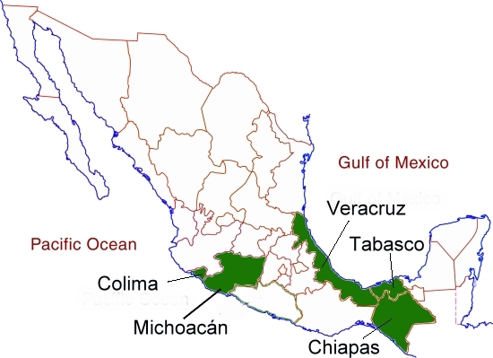
Mexico's banana-growing states

Mexico’s banana-growing states [corrected]

The main banana producing states (see map) in Mexico are:

  • Chiapas (35% of national production), especially the municipality of Tapachula
  • Tabasco (25%), where average price per metric ton is lower. Mexico’s largest banana exporting company, San Carlos Tropical Exports, is based in Tabasco.
  • Veracruz (13%), especially in the municipalities of Martínez de la Torre, Atzalán, Tlapacoyán, Nautla and Papantla
  • Michoacán and Colima (6.5% each)

Bananas are also grown, on a smaller scale, in Jalisco (4.5%), Guerrero and Oaxaca (3% each) and Nayarit (2%).

Maps showing banana cultivation areas in individual states can be generated via SIAP, the Agriculture Secretariat’s online database system.

Trade in bananas

The world’s major importers are the USA (bananas are the single most widely eaten fruit in that country), Germany, Japan, Russia, UK, Italy, France, Sweden and China.

Bananas were first introduced into US diets (from Cuba) in the early 19th century. The earliest large-scale shipments of bananas to the USA were from Jamaica in the 1870s, and were organized by Lorenzo Dow Baker, who later founded the Boston Fruit Company, which later became the United Fruit Company, now Chiquita Brands International.

Banana exports from Mexico have risen rapidly in recent years and reached 307,000 metric tons in 2012 (compared to 60,000 tons in 2005), worth about 140 million dollars. The USA is the world’s largest importer of bananas and Mexico’s main foreign market, receiving 80% of all exports of Mexican bananas.

Source for history of bananas:

  • Jenkins, Virginia S. Bananas: An American History. Washington: Smithsonian Institution, 2000

Other posts related to agricultural products:

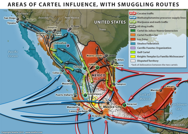
Mexico’s drug cartels and their areas of operation, a 2014 update

 Mexico's geography in the Press, Updates to Geo-Mexico  Comments Off on Mexico’s drug cartels and their areas of operation, a 2014 update
Feb 172014
 

As noted in previous updates on Mexico’s drug cartels and their shifting areas (and methods) of operation, it is becoming ever harder to keep up-to-date with the geography of drug cartel territories. The current federal administration has deliberately limited the amount of hard data relating to drug violence published on government sites or in Mexico’s mainstream press. While this may help to reduce public unease at the levels of drug-related crime, it also means that it has become much harder to analyse the situation and determine overall patterns and trends.

The 2013 UN Global Report on Drugs estimates that Mexico is Latin America`s largest drugs producer, making 30 times more heroin than Colombia. The report also cites statistics showing that more methamphetamine are confiscated in Mexico than in the rest of the world combined.

Previous updates:

The main players  (February 2014) are:

  1. Los Zetas, operating in more than half of Mexico’s 32 states (more territory than their main rivals the Sinaloa Federation), and prone to extreme violence. They have branched out into human trafficking and extortion to support their drug smuggling operations. They control much of eastern Mexico. Even the capture of their top leader in 2013 does not appear to have significantly weakened their internal cohesion.
  2. Sinaloa Federation, which remains in control of most of western Mexico, and increasingly specializes in the production of methamphetamine. The cartel is led by Joaquín “El Chapo” Guzmán, whose estimated personal net worth exceeds $1 billion dollars according to Forbes magazine. Guzmán escaped from a high secrutiy jail in 2003 but was recaptured in Mazatlán in February 2014.
  3. Gulf Cartel, still important along Mexico’s Gulf coast, but weakened due to infighting, captures of leaders, and conflicts with Los Zetas.
  4. Knights Templar (Los Caballeros Templarios), started in 2010 by former members of The Michoacán Family (La Familia Michoacana), and which now controls much of the drug-related activity in Michoacán and Guerrero. They are in near-constant conflict with the Jalisco New Generation Cartel (based in the neighboring state of Jalisco) which has resulted in continued violence along the Jalisco-Michoacán border.

Smaller, regional players:

  1. Tijuana Cartel, operating in the city of Tijuana on the Baja California/California border.
  2. Juárez Cartel, now largely limited to Cd. Juárez and the border with Texas. Mexican federal police say this group now calls itself the New Juárez Cartel (Nuevo Cartel de Juárez).
  3. Jalisco New Generation Cartel (Cartel Jalisco Nueva Generación), based in the state of Jalisco and thought to operate as enforcers for the Sinaloa Federation
  4. Cartel del Pacífico Sur; weak, and competing with Zetas, mainly in the central Mexico state of Guerrero
  5. Independent Cartel of Acapulco, small and apparently declining in importance

Splinter groups (see below):

  1. Sangre Z
  2. Golfo Nueva Generación
  3. La Corona
Cartel areas and drug routes in Mexico

Cartel areas and drug routes in Mexico, 2012. Copyright Stratfor. Click map for enlarged version

Recent changes (2013-2014)

Early in 2013, Mexico’s National Security Cabinet revealed the emergence of several new drug trafficking organizations. The new groups–Sangre Z, Golfo Nueva Generación, and La Corona– are splinter groups from Los Zetas, the Gulf Cartel, and the Sinaloa Federation respectively. The new groups formed in response to the arrest of key operatives in the large cartels. These new groups are reported to be well equipped and well-armed, generating revenue through drug trafficking and by levying protection payments on other drug traffickers who pass through their turf on their way to the USA..

In 2013, the situation in the western state of Michoacán became particularly unstable with drug-related violence (shootouts, roadblocks and the torchings of vehicles) perpetrated by the Knights Templar in many parts of the state. The town of Apatzingan in the Tierra Caliente region of Michoacán is the main bastion of the Knights Templar organization. The increased violence resulted in the well-publicized rise of civilian “vigilante” militia groups (community self-defense groups), prepared to take on cartel members in direct combat in their efforts to reduce the incidence of extortion, kidnappings and other crimes. Self-defense groups sprang up in more than 30 municipalities in Michoacán including at least 15 of the state’s 113 cities. Places with self-defense groups included Buenavista Tomatlan, Coalcoman, Tepalcatepec, Los Reyes, Aquila, Paracho, Cheran, Tancitaro, Paracuaro and Nueva Italia.

For a good summary account of the struggle between the Knights Templar and the vigilantes, see Mexican Vigilantes Beat Back Ruthless Knights Templar Cartel by journalist Ioan Grillo. We will take a closer look at the Knights Templar in a future post.

In recent months, in the wake of drug gang attacks on gas stations and electricity facilities in Michoacán, the federal government has stepped up its attempts to resolve the security problems in the state. In some places, it has replaced city officials and local police forces en masse. In the important Pacific Coast port of Lázaro Cárdenas (a main port of entry for the chemicals used for methamphetamine production, and a main export port for minerals, one of the more lucrative sources of income for the Knights Templar), the federal government sent in the military to administer the port.

In their efforts to curb the rise of civilian militia groups, the federal and state governments have announced a scheme which allows militia members to register to join new, state-controlled Rural Protection Forces (RPF). As of early February 2014, about 500 “self-defense” members had already registered to join the RPF.

The federal government has also announced the creation of a 3.5-billion-dollar purse to support 250 specific actions in Michoacán designed to reactivate the state’s economy, reinforce security and aid its social assistance programs.

Related posts (chronological order):

The pattern of violent crimes in Mexico in 2013

 Mexico's geography in the Press, Updates to Geo-Mexico  Comments Off on The pattern of violent crimes in Mexico in 2013
Feb 082014
 

The Consejo Ciudadano para la Seguridad Pública y la Justicia Penal AC, a Mexican non-profit, has published an interesting report looking at the levels of violent crime in Mexico in 2013:

The authors take violent crimes to include intentional homicide, kidnapping, rape, aggravated assault, robbery with violence and extortion.

At the municipal level, violent crime is concentrated in a relatively small number of municipalities. The report looks at the statistics for the 216 municipalities (including delegaciones of the Federal District) that had estimated populations of over 100,000 in 2013. Since 2012, four municipalities have joined this group: El Fuerte (Sinaloa), Tepotzotlán (México), Pánuco (Veracruz) y Playas de Rosarito (Baja California). Between them, the 216 municipalities are home to about 64% of Mexico’s total population.

Data from government agencies and INEGI were used to compile rates for each crime in each municipality. These rates were then multiplied by the following weightings (to reflect the relative severity and impacts of each type of crime),

  • 0.55 for intentional homicide
  • 0.22 for kidnapping
  • 0.13 for rape
  • 0.04 for aggravated assault
  • 0.03 for robbery with violence
  • 0.03 for extortion

and summed to give an overall index for “violent crimes”.  For the 231 municipalities, the index ranged from 106.63 for Oaxaca, Oaxaca to 0.00 for Zapotlán el Grande in Jalisco. The full details of the methodology are explained and discussed in the report. A similar methodology was also used to calculate levels of violence by state.

The worst 10 municipalities in terms of violent crime were:

  1. Oaxaca, Oaxaca – violent crime index value of 106.63
  2. Acapulco, Guerrero – 80.35
  3. Cuernavaca, Morelos – 65.30
  4. Yautepec, Morelos – 56.19
  5. San Pedro, Coahuila – 53.42
  6. Cd. Victoria, Tamaulipas – 52.48
  7. Iguala de la Independencia, Guerrero – 52.25
  8. El Fuerte, Sinaloa – 50.82
  9. Jiutepec, Morelos – 50.29
  10. Torreón, Coahuila – 49.31

The national index (ie treating the entire country as a single entity) was 23.17, meaning that the index value for violent crimes in Oaxaca, Oaxaca, was more than four times that of the country as a whole.

Municipalities which were in the worst twenty in 2012 for violent crime, but have now fallen out of that group include: Lerdo (Durango) Zacatecas (Zacatecas), Cuautla (Morelos), Zihuatanejo (Guerrero), Temixco (Morelos), Cuauhtémoc (DF), Tecomán (Colima), Navolato (Sinaloa), Centro (Tabasco) and Monterrey (Nuevo León).

Moving into the worst twenty for the first time are: Playas de Rosarito (Baja California), Hidalgo del Parral (Chihuahua) San Pedro (Coahuila), Chilpancingo (Guerrero), El Fuerte (Sinaloa) and Chalco, Cuautitlán, Cuautitlán Izcalli, Ecatepec and Naucalpan (all in the State of Mexico).

Of the 213 municipalities, Acapulco had the highest intentional homicide rate (112.81/100,000, about 6 times the national rate of 19.05/100,000). Cd Victoria had the highest kidnapping rate (23.28/100,000, 15 times higher than the national rate of 1.46/100,000, though kidnapping rates in Mexico are notoriously unreliable, and have been the subject of intense press debate in recent months).

Violent crimes by state, 2013

By state (see map), Guerrero had the highest violent crime index with 47.76 points, followed by Morelos 43.99 and Chihuahua 40.87. In general, with the prominent exceptions of the State of México and Guerrero, the southern half of Mexico appears to be somewhat safer than the northern half.

Map of Violent crime index, 2013

Violent crime index, 2013. Source of data: see post. Credit: Geo-Mexico

For individual categories of crime at the state scale, Morelos had the highest kidnapping rate (8.24/100,000). Quintana Roo had the highest rate of rape (28.31/100,000, compared to national average of 11.36/100,000). The State of Mexico had the highest rate for aggravated assault (251.64/100,000 compared to national average of 130.21/100,000). Morelos came out on top for the highest rate of robbery with violence (455.08/100,000 compared to national average of 182.61) and for the highest rate of extortion (21.96/100,000 compared to national average of 6.94/100,000).

Good news for tourists

According to this report, almost all of Mexico’s major tourist destinations (with the noteworthy exception of Acapulco) are located in areas where violent crime is below the national average.

Related posts:

Water management progress in the Lerma-Chapala basin

 Books and resources  Comments Off on Water management progress in the Lerma-Chapala basin
Jan 112014
 

The Lerma-Chapala Basin (see map) is one of Mexico’s major river systems, comprising portions of 127 municipalities in five states: México, Querétaro, Michoacán, Guanajuato and Jalisco.

The basin has considerable economic importance. It occupies only 2.9% of Mexico’s total landmass, but is home to 9.3% of Mexico’s total population, and its economic activities account for 11.5% of national GDP. The basin’s GDP (about 80 billion dollars/year) is higher than the GDP of many countries, including Guatemala, Costa Rica, Honduras, Paraguay, Bolivia, Uruguay, Croatia, Jordan, North Korea and Slovenia.

Lerma-Chapala Basin

The Lerma-Chapala Basin. Click map to enlarge. Credit: Tony Burton / Geo-Mexico

Given this level of economic activity, it is probably not surprising that the pressures on natural resources in the basin, especially water, are enormous. Historically, the downstream consequence of the Lerma Basin’s agricultural and industrial success has been an inadequate supply of (heavily polluted) water to Lake Chapala.

Following decades of political inactivity or ineffectiveness in managing the basin’s water resources, solid progress finally appears to have been made. Part of the problem previously was a distinct lack of hard information about this region at the river basin scale. The statistics for such key elements as water usage, number of wells, replenishment rates, etc. were all (to put it politely) contested.

Fortunately, several scientific publications in recent years have redressed the balance, and the Lerma-Chapala Basin is now probably the best documented river basin in Mexico. This has allowed state and federal governments to negotiate a series of management agreements that are showing some positive signs of success.

The first of these key publications was “The Lerma-Chapala Watershed: Evaluation and Management“, edited by Anne M. Hansen and Manfred van Afferden (Klewer Academic/Plenum Publishers, 2001). This collection of articles featured contributions from researchers in several universities and research centers, including the University of Guadalajara, Mexican Institute of Water Technology, Autonomous University of Guadalajara, Baylor University, the Harvard School of Public Health and Environment Canada. Click here for my comprehensive description and review of this volume on MexConnect.com.

Perhaps the single most important publication was the Atlas de la cuenca Lerma-Chapala, construyendo una visión conjunta in 2006. Cotler Ávalos, Helena; Marisa Mazari Hiriart y José de Anda Sánchez (eds.), SEMARNATINE-UNAM-IE, México, 2006, 196 pages. (The link is to a low-resolution pdf of the entire atlas). The atlas’s 196 pages showcase specially-commissioned maps of climate, soils, vegetation, land use, urban growth, water quality,  and a myriad of other topics.

More recently, a Case Study of the Lerma-Chapala river basin: : A fruitful sustainable water management experience was prepared in 2012 for the 4th UN World Water Development Report “Managing water under uncertainty and risk”. This detailed case study should prove to be especially useful in high school and university classes.

The Case Study provides a solid background to the Lerma-Chapala basin, including development indicators, followed by a history of attempts to provide a structural framework for its management.

In the words of its authors, “The Lerma Chapala Case Study is a story of how the rapid economic and demographic growth of post-Second World War Mexico, a period known as the “Mexican Miracle”, turned into a shambles when water resources and sustainable balances were lost, leading to pressure on water resources and their management, including water allocation conflicts and social turbulence.”

On a positive note, the study describes how meticulous study of the main interactions between water and other key development elements such as economic activity and social structures, enabled a thorough assessment on how to drive change in a manner largely accepted by the key stakeholders.

The early results are “stimulating”. “Drawbacks and obstacles are formidable. The main yields are water treatment and allocation, finances, public awareness, participation and involvement. The main obstacles are centralization, turbid interests, weak capacity building, fragile water knowledge; continuity; financial constraints; and weak planning.”

Sustainable water usage is still a long way off. As the Case Study cautions, “There is still much to do, considering the system Lerma-Chapala responds directly to a hydrologic system where joint action and especially abundant involvement of informed users is required, to achieve sustainable use of water resource.”

One minor caveat is that the Case Study does not offer full bibliographic reference for all of the maps it uses, which include several from the previously-described Atlas de la cuenca Lerma-Chapala, construyendo una visión conjunta.

Related posts:

The transformation of Real de Catorce from ghost town to film set and Magic Town

 Other  Comments Off on The transformation of Real de Catorce from ghost town to film set and Magic Town
Dec 262013
 

Both the name and the coat-of-arms of the state of San Luis Potosi recall the tremendous importance of mining to Mexico’s economy.

SLP-coat-of-armsCalled Potosí in emulation of the mines of that name high in the Bolivian Andes, the city’s coat-of-arms, awarded in 1656, has its patron saint standing atop a hill in which are three mine shafts. Left of the hill are two gold ingots, and right of it, two silver ones.

Some of the early mining towns in San Luis Potosí faded into obscurity, others became centers for ranching and commerce. The best known former mining town, Real de Catorce, for long considered a ghost town, has been resuscitated by tourism.

For visitors planning to see Real de Catorce, the best place to stay the night before is Matehuala, on highway 57, which has a full range of tourist services. From Matehuala, it is short distance west to Cedral. Shortly after Cedral a 24-kilometer-long cobblestone road climbs up the mountain to Real de Catorce, which sits at an elevation of  2,743 meters (9,000 ft) in the Sierra de Catorce range.

Real de Catorce

Main street of Real de Catorce. Credit: Tony

Main street of Real de Catorce. Credit: Tony Burton

The first surprise for visitors is the single file 2,300 meter long Ogarrio tunnel – the only entrance to the town from the north – a unique introduction to the many strange things awaiting you on the other side. The second surprise  is how such a large place, which produced more than 3 million dollars worth of silver each year, could ever have become a ghost town. Between 1788 and 1806, the La Purisima mine alone yielded annually more than $200,000 pesos of silver– and that was when a peso of silver was equivalent to a dollar.

The large, stone houses, often of several stories, with tiled roofs, wooden window frames and wrought-iron work, were so well built that they have survived to tell you their tales as you wander through the steep streets, soaking up the atmosphere of one of Mexico’s most curious places.

You need time to really appreciate the former grandeur of Real de Catorce. Fortunately, there are several simple hotels and restaurants. It is well worth hiring a local guide.  An enthusiastic guide will wear your feet out long before you tire of their informative commentaries.

Seek out the beautifully restored palenque (cock-fighting pit). Pause in the church to examine the mesquite floor, imaginatively described in some guidebooks as comprised of a mosaic of coffin lids. The church is dedicated to Saint Francis of Assisi. The two week long fiesta in his honor, centered on October 4th, is a huge affair, attended by hundreds of returning Real de Catorce families.

In front of the church, across the small plaza of Carbón, is the former mint. This gorgeous building is well worth visiting and now used for cultural events such as photographic exhibitions. Look in the gallery and perhaps you’ll find an irresistible, original, handcrafted item made of locally mined silver.

The town of Real de Catorce and its surroundings are sufficiently photogenic that several movies have been filmed here, including Bandidas (featuring Salma Hayek and Penélope Cruz) and The Mexican (featuring Brad Pitt and Julia Roberts).

The town, designated a Magic Town in 2001, has several small hotels and restaurants for those wanting to spend more time here.

This area has close associations with the indigenous Huichol (Wixarika) Indians who call this area Wirikuta. Each spring, they visit Cerro del Quemado, a hill within easy hiking distance of Real de Catorce, to leave religious offerings. The Huichol collect the hallucinogenic cactus peyote, used in some of their ceremonies, from the surrounding desert during an annual spiritual pilgrimage to Wirikuta from their heartland in northern Jalisco, 400 km (250) miles away. Cerro del Quemado was declared a National Sacred Site in 2011. An upcoming full length documentary about the Huichol Indians, the “Huicholes: The Last Peyote Guardians“, includes shots of the pilgrimage, while looking at how the continuation of the pilgrimages could be threatened by proposed mining projects.

Related posts:

Dec 052013
 

After studying 22 countries with sizable retirement communities, International Living (a consultancy group) rated Mexico as the fourth most attractive country for foreigners to retire to in 2013, after Ecuador, Panama and Malaysia. The study looked at eight factors: real estate, benefits for retired people, cost of living, integration, entertainment, health, infrastructure and climate.

According to the US Census Bureau, there are 41 million people of retirement age in the USA. More than half of them have annual incomes of between 70,000 and 150,000 dollars, and they are expected, on average, to live to the age of 83; 80% are home owners. This number will swell to 72.8 million by 2030, 40% of whom may have difficulties maintaining their previous lifestyles during retirement. Given its proximity, this makes Mexico an attractive destination for many baby-boomers seeking a comfortable retirement lifestyle.

But where in Mexico will these retirees choose to live?

According to this analysis by the consultancy Aregional, there are 36 specific areas in Mexico where the real estate market is targeting US baby boomers seeking a place to retire. About half of these locations (see map) are in central and western Mexico. Locations in these regions include Guanajuato and San Miguel de Allende (both in the state of Guanajuato), Colima, Comala and Manzanillo (Colima); Chapala, Ajijic and Puerto Vallarta (Jalisco); and Nuevo Vallarta and Punta Mita (Nayarit).

Locations of retiree real estate developments. Credit: Aregional

Locations of retiree real estate developments. Credit: Aregional

Locations in northern Mexico important for retiree real estate include Rosarito, Ensenada and Los Algodones (Baja California); Los Cabos, La Paz and Loreto (Baja California Sur); Puerto Peñasco (Sonora) and Mazatlán (Sinaloa). [Kudos to RickS for noticing that Puerto Peñasco is not located very accurately!]

Retiree real estate is also prominent in several places in the south and south-east of Mexico, including  Acapulco and Punta Ixtapa (Guerrero); Huatulco (Oaxaca); Playa del Carmen and Cancún  (Quintana Roo); Puerto Progreso (Yucatán), as well as the cities of Campeche and Veracruz.

It is not known how many US retirees have already chosen to live in Mexico. While it is relatively easy to quantify the number of retiree tourists (those staying more than one night, but less than six months), it is impossible to accurately quantify the number of non-working, non-Mexicans who have chosen to relocate full-time to Mexico. Technically, these “residential tourists” are not really tourists at all but longer-term migrants holding residency visas.

Residential tourists already form a very distinct group in several Mexican towns and cities, with lifestyle needs and spending patterns that are very different from those of regular tourists. Their additional economic impact is believed to exceed $500 million a year.

A case study of residential tourism, and its pros and cons, in Chapala-Ajijic on the northern shore of Lake Chapala is an integral part of chapter 19 of Geo-Mexico: the geography and dynamics of modern Mexico.

Posts related to retirees in Mexico:

Many Mexican Bracero workers still trying to claim their pay

 Excerpts from Geo-Mexico, Updates to Geo-Mexico  Comments Off on Many Mexican Bracero workers still trying to claim their pay
Nov 302013
 

In response to severe labor needs during the second world war, the governments of Mexico and the USA initiated the Bracero guest worker program in 1942. The program enabled Mexico to contribute to the war effort by sending temporary agricultural workers to the USA. Mexicans were granted renewable six month visas to work on selected farms. Most migrants under the Bracero program came from the same three states, Michoacán, Jalisco and Guanajuato. They worked mostly in California and other states along the Mexican border.

Los BracerosAs a result of the Bracero program, some farmers in the USA became very dependent on relatively cheap Mexican labor. The program was considered a great success by farmers. Unfortunately mistreatment of Bracero laborers was widespread. In protest, the Mexican Government threatened to stop the flow of migrants. During the war many Mexicans who were not recruited under the Bracero program entered the USA illegally looking for work. Tolerance for unauthorized migration developed on both sides of the border. With a large dependency in the USA on Mexican farm workers and a large supply in Mexico, there was virtually no way to put a halt to this migration stream.

Labor unions, churches and Latino groups in the USA opposed the Bracero program on the grounds that it held down farm wages and impeded the upward mobility of US Hispanics. They convinced the US Congress to halt the Bracero program in 1964. Between 1942 and 1964 an estimated 4.5 million Mexican Bracero workers entered the USA. At its height in the late 1950s more than 500,000 workers migrated each year. Most were temporary migrants who returned to Mexico within a year, often settling in larger cities, exacerbating the flow of migrants from rural areas to the growing cities. The Bracero program set the stage for the continued high volume of Mexican labor migration to the USA.

In an effort to ensure that the Bracero workers were only temporary migrants to the USA, the US government withheld 10% of all their earnings. The US government then remitted this amount to the Mexican government for payment to the workers on their return home. More than 70 years after the Bracero program started, many braceros are still trying to claim money that they earned legitimately years ago and that is still owed to them by the Mexican government.

The struggles of temporary bracero workers who were never repaid the 10% that had been withheld, are detailed in a short October 2013 article entitled “Bracero Guestworkers, Unpaid”, written by Adam Goodman and Verónica Zapata Rivera (history doctorate students at, respectively, the University of Pennsylvania and Mexico’s National Autonomous University).

The article also describes some of the other injustices faced by Bracero workers, including forced whole-body fumigation with DDT as they crossed the US border.

For more information about the Bracero program, see The Bracero Archive

Related posts:

Geotourism in Mexico: García Caves (Grutas de García) in Nuevo León

 Other  Comments Off on Geotourism in Mexico: García Caves (Grutas de García) in Nuevo León
Oct 032013
 

The Garcia Caves (Grutas de García) are located in the Cumbres de Monterrey National Park, 9 km from the small town of Villa de García, and about 30 km from the city of Monterrey (state capital of Nuevo León). The highest point in the park is Copete de las Águilas which rises to 2260 m (7,410 ft) above sea level, but its best known peak is Saddle Hill (Cerro de la Silla), the distinctive saddle-shaped hill that overlooks the city.

Much of the park, including the mountains, are composed of sedimentary rocks that were originally laid down as marine sediments and then subsequently folded, uplifted and exposed to erosion. The extensive areas of limestone in the park, which date from the Cretaceous period, have been subject to karstification over 50 to 60 million years, which has resulted in typical karst landforms such as sinkholes, caves, cave formations and underground streams.

The Garcia Caves, one of the largest cave systems in Mexico, are deep inside the imposing Cerro del Fraile, a mountain whose summit rises to an elevation of 1080 meters above sea level, more than 700 meters above the main access road. The entrance to the caves is usually accessed via a short ride on a 625-meter cable car that was built to replace a funicular railway.

The cave system was first reported in 1843 by the Marmolejo family who informed their local prist Juan Antonio Sobrevilla that they had stumbled across it while looking for firewood.

Grutas de García. Credit: María de Lourdes Alonso

Grutas de García. Credit: María de Lourdes Alonso

Guided tours of the cave system show visitors some of its 27 separate chambers along a 2.5-kilometer (1.6 mile) route. The full system extends more than a kilometer further into the mountain reaching depths of more than 100 meters (340 feet) beneath the surface. The limestone of the cave walls contains lots of marine fossils. The caves have extensive and impressive formations of dripstone, including stalactities, stalagmites and other forms.

Unlike the suffocating heat of the Naica Crystal Caves in Chihuahua, the cave temperature here remains about 18̊C (65̊F) all year.

The chambers and formations have been given whimsical and imaginative names such as

  • “El salón de la luz” (The Light Chamber) where the natural translucence of the ceiling rock allows light from the outside to filter through.
  • “La octava maravilla” (The Eighth Wonder), a natural column formed where a stalagmite growing from the floor joined a stalactite, growing from the ceiling
  • “El mirador de la mano”, a stalagmite shaped like a human hand.
  • “El Nacimiento” (The Nativity),
  • “La Fuente Congelada” (The Frozen Fountain),
  • “La Torre China” (The Chinese Tower),
  • “El teatro” (The Theatre), and
  • “El Árbol de Navidad” (The Christmas Tree).

Want to read more about caves in Mexico?

Visit John Pint’s website for a selection of his writing, with many original articles, illustrated with great photographs, about many individual caves in Mexico.

Related posts

The geography of gold mining in Mexico

 Updates to Geo-Mexico  Comments Off on The geography of gold mining in Mexico
Sep 122013
 

Production of gold has more than tripled from the 23.5 metric tons recorded in 2000 to 88.6 metric tons in 2012, 3.2% of world production, 5.3% more than the previous year, and the ninth consecutive year-on-year increase. Analysts believe that gold production will double again between now and 2020.

Mexico is the world’s 11th largest producer of gold, well behind China (13% of world total), Australia (10%)  the USA (9%) and Russia (7%). Mexico exports gold, mainly to the USA and Switzerland.

The vast majority of gold and silver production in Mexico comes from a handful of major corporations, led by Canadian mining firm Goldcorp, whose main mines are at Los Filos (Guerrero) and Peñasquito (Zacatecas).

Gold production in Mexico, 2011. Data: INEGI. Credit: Tony Burton/Geo-Mexico

Gold production in Mexico, 2011. Data: INEGI. Credit: Tony Burton/Geo-Mexico

The map shows the six main gold mining states in Mexico. Production in Sonora has grown rapidly in the past decade and that state is now responsible for 32% of national production, ahead of Zacatecas (20%), Chihuahua (15%), Guerrero (13%), Durango (9%) and San Luis Potosí (7%).

The main gold-mining municipalities in each of these six states are:

  • Sonora: Caborca, Sahuaripa, Santa Ana, Álamos, Altar and Trincheras
  • Zacatecas: Mazapil, Luis Moya, Ojocaliente, Fresnillo and Concepción del Oro
  • Chihuahua: Urique, Chinipas, Ocampo, Madera
  • Guerrero: Eduardo Neri and Coyuca de Catalán
  • Durango: Santiago Papasquiaro and San Dimas
  • San Luis Potosí: Villa de la Paz

We will explore the controversy surrounding Goldcorp’s Los Filos opencast mine in Guerrero, billed as Latin America’s largest gold mine development, and some other mining controversies in Mexico, in a future post.

Mining towns described briefly previously on Geo-Mexico.com include:

Related posts:

Sep 092013
 

Prior to European contact in 1519, what did the Aztec people eat?

The basis of Aztec diet was corn (maize). They cultivated numerous varieties of corn, as well as many other crops including beans, amaranth and squash. Some dishes were seasoned with salt and chili peppers. This mix of items provided a balanced diet that had no significant vitamin or mineral deficiency.

In addition, the Aztec diet included tomatoes, limes, cashews, potatoes, sweet potatoes, peanuts, cacao (chocolate), wild fruits, cactus, mushrooms, fungi, honey, turkey, eggs, dog, duck, fish, the occasional deer, iguana, alongside insects such as grasshoppers. From the lake water, they scooped high protein algae (tecuitlatl), which was also used as a fertilizer.

How did they obtain their food?

The Mexica (who later became the Aztecs) faced a particular dilemma, largely of their own making. Mexica (Aztec) legend tells that they left their home Aztlán (location unproven) on a lengthy pilgrimage lasting hundreds of years. They were seeking a specific sign telling them where to found their new capital and ceremonial center. The sign was an eagle, perched on a cactus. Today, this unlikely combination, with the eagle now devouring a serpent, is a national symbol and appears on the national flag.

Artist's view of the Aztec capital Tenochititlan in the Valley of Mexico

Artist’s view of the Aztec capital Tenochititlan in the Valley of Mexico

The dilemma arose because they first saw this sign, and founded their new capital Tenochtitlan, on an island in the middle of a lake in central Mexico. An island linked by causeways to several places on the “mainland” might have had some advantages in terms of defense, but supplying the growing settlement with food and fresh water was more of a challenge.

Much of their food came from hunting and gathering, and some food was brought by long-distance trade, but space for farming, especially on the island, was at a premium.

The Aztecs solved their dilemma of how to supply food to their island capital by developing a sophisticated wetland farming system involving raised beds (chinampas) built in the lake (see image below). Originally these chinampas were free-floating but over time they became rooted to the lake floor. The chinampas were separated by narrow canals, barely wide enough for small boats or canoes.

Artist's representation of chinampa farming

Artist’s representation of chinampa farming

From an ecological perspective, these chinampas represented an extraordinary achievement, a food production system which proved to be one of the most environmentally sustainable and high-yielding farming systems anywhere on the planet!

Constructing and maintaining chinampas required a significant input of labor, but the yields per unit area could be very high indeed, especially since four harvests a year were possible for some crops. The system enabled fresh produce to be supplied to the city even during the region’s long dry season, whereas food availability from rain-fed agriculture was highly seasonal.

Artist's interpretation of chinampa construction (from Rojas 1995)

Artist’s interpretation of chinampa construction (from Rojas 1995)

The planting platforms or chinampas were built by hand, with alternate layers of mud, silt and vegetation piled onto a mesh of reeds or branches. Platforms, often but not necessarily rectangular, were about 10 meters wide and could be 100 meters or more in length. Willow trees were often planted on the edges of platforms to help stabilize them and provide shade for other plants and for the canals that separated the platforms. Interplanting crops was common, and polyculture was the norm. For many crops, multicropping (several crops in a single year) was possible.

Because the planting platforms were close to water, extremes of temperature were dampened, and the likelihood of frost damage to crops reduced. The root systems of crops had reliable access to fresh water (sub-irrigation). The canals provided a variety of habitats for fish. The mud from the bottom of canals was periodically dredged by hand and added to the platforms, supplying nutrients and preserving canal depth. Together with the regular addition of waste organic material (compost), this replenished the platforms and meant that their fertility was maintained over very long periods of time.

The system could even cope with polluted water, since the combination of constant filtration on the platforms, and aquatic weeds in the canals, partially removed most impurities from the water.

Where can chinampas be seen today?

Archaeologists have found vestiges of chinampas in several regions of Mexico, some dating back almost 3000 years.

Mexico’s best known chinampas today are those in Xochimilco on the south-eastern outskirts of Mexico City. Xochimilco is a Unesco World Heritage site, but faces heavy pressure from urban encroachment and highway construction. Xochimilco’s canals (with chinampas separating them) are some of the last surviving remnants of the large lake that occupied this valley when the Mexica founded Tenochititlan.

Xochimilco (Wikipedia; creative commons)

Xochimilco (Wikipedia; creative commons)

Visiting Xochimilco’s canals and market is a popular weekend excursion for Mexico City residents and tourists alike. However, the modern-day chinampas of Xochimilco are not the same as they would have been centuries ago. First, the total area of chinampas in Xochimilco is only a fraction of what once existed. Secondly, some of the chinampas have been abandoned, while on others chemical fertilizers and pesticides are often used. Thirdly, the area now has many exotic species, including introduced species of fish (such as African tilapia and Asian carp) that threaten native species. Numbers of the axolotl (a local salamander), a prized delicacy on Aztec dinner tables, are in sharp decline. Fourthly, the water table in this area fell dramatically during the last century as Mexico City sucked water from the underground aquifers causing local springs that helped supply Xochimilco to dry up completely. Rubble from the 1985 Mexico City earthquake was also dumped in Xochimilco’s canals.

Lakes in some other parts of Mexico were also used for chinampa farming. For example, in Jalisco, just west of Guadalajara, Magdalena Lake “was a prime source of food for the 60,000 or so people living close to the Guachimontones ceremonial site (settled before 350 BC) in Teuchitlán. They learned to construct chinampas, fixed mud beds in the lake, each measuring about 20 meters by 15 meters, which they planted with a variety of crops… The remains of hundreds of these highly productive islets are still visible today.” (Western Mexico: A Traveler’s Treasury, p 69)

Chinampa farming was one of the great agricultural developments in the Americas. It was, and still can be, an environmentally-sensitive and sustainable method of intensive wetland agriculture.

If you enjoyed this…

You might well enjoy my latest book: Mexican Kaleidoscope: myths, mysteries and mystique

Want to read more?

Related posts