admin

Dramatic fall in grain production means higher imports

 Mexico's geography in the Press  Comments Off on Dramatic fall in grain production means higher imports
Dec 082011
 

Mexico’s production of basic grains has fallen 8.5% this year (compared to 2010) to 28.5 million metric tons, according to FAO (Food and Agriculture Organization) estimates. This is a very serious fall, exceeded (on a percentage basis) only by South Africa (15.8%) and Ethiopia (11.3%).

As a result of the fall in production (largely due to the drought affecting much of the northern part of the country), Mexico is expected to import about 11 million tons of grain, mainly corn, almost a million tons more than last year.

Mexico was the world’s 6th largest grain producer in 2010, but has fallen to 8th spot in 2011, overtaken by Russia and Argentina. The world’s five largest grain producers are USA, China, European Union, Brazil and India. Countries lagging behind Mexico for production of basic grains include Canada, Australia, Indonesia and Nigeria.

Dec 072011
 

The federal government has announced a six-year overhaul of Mexico’s domestic natural gas market, coupled with building some major extensions to the existing natural gas pipeline network.

Recent discoveries of massive reserves of shale gas have prompted the government to abandon plans to build more nuclear power stations and focus more attention on natural gas. New combined-cycle power stations are planned, alongside 4,400 km of new pipelines, which will be funded by 8 billion dollars of public-private financing and bring natural gas to more than 5 million potential consumers for the first time.

The expansion of Mexico’s pipeline network will extend the system into four states–Zacatecas, Colima, Sinaloa and Morelos–where natural gas was previously unavailable. The improvements in infrastructure should persuade many businesses to switch from oil and liquid petroleum gas to cleaner and less expensive natural gas.

Projected gas pipeline network, 2020.

Mexico's projected natural gas pipeline network, 2020.

The major projects are shown on the map (green pipelines already exist). The Manzanillo-Guadalajara section (shown in red) is already built and being subjected to final testing before being brought on-stream early in 2012. It will immediately increase the competitiveness of companies in several key parts of central Mexico.

Related posts:


Mexico’s 2011 drought is raising the price of basic foodstuffs

 Mexico's geography in the Press  Comments Off on Mexico’s 2011 drought is raising the price of basic foodstuffs
Dec 052011
 

This year’s drought – see Many states in Mexico badly affected by drought is now widely viewed as the worst to occur since modern record-keeping for precipitation began about 80 years ago.

Short-term droughts are not unusual in Mexico. As the graph shows, there is a clear cyclical pattern to the timing of short-term droughts in Mexico. This is because most of the country receives almost all its annual precipitation in just a few months, from May or June (depending on precise location) to September-October.

The scale of the current drought is readily apparent from the graph. This year, far more of the country is affected, and the level of drought is far more severe.

Seasonal drought in Mexico, 2003-2012
Seasonal drought in Mexico, 2003-2012. Click to enlarge.

The drought is having numerous adverse impacts

It is already having an effect on food prices. Several of the basic foodstuffs  making up Mexico’s basic basket of goods for economic indices such as the inflation index, have risen sharply in price in recent months. A shortage of corn has led to a 70% increase in imports of yellow corn from the USA.

Incredibly, Mexico, the home of corn, is now the world’s second largest importer. Corn, as we have noted in previous posts, is a vital ingredient in Mexican cuisine, and is particularly important in the southern half of the country, especially in the more rural and indigenous areas. The shortage of corn has led to a rise in the price of tortillas, a dietary staple in almost all of the country. Tortilla prices have risen up to 18%, many times Mexico’s overall inflation rate of about 3.5%.

The production of chiles, another staple of the Mexican diet, has also fallen due to the drought, by an estimated 40%. In Zacatecas, that state’s 2,500 chile-growers will have produced 120,000 tons of green chile and 62,150 tons of dried chile this year, even though they have only been able to harvest chiles twice this year, rather than the normal four times. The state is the leading source of dried chile in Mexico. The area cultivated for chiles in Zacatecas has also fallen this year, to 31,300 hectares. The decrease in production has had a direct impact on the number of harvesting jobs available, since each hectare of chile cultivation usually means 150 seasonal jobs. The production shortage for chiles will be offset by more imports from Peru and China.

At latest count, 770 municipalities are now suffering from drought, and at least 2.5 million people in 1500 communities are left with insufficient drinking water. In the state of Durango alone, more than one million people are currently experiencing extreme drought, and 149 communities are completely without drinking water.

The long-term outlook is not favorable for these areas since climate change is expected to increase both the frequency and severity of droughts over the next twenty to thirty years.

Related posts:

The important but often overlooked state of Puebla

 Other  Comments Off on The important but often overlooked state of Puebla
Dec 022011
 

The interesting and important state of Puebla is often overlooked because it is overshadowed by nearby Mexico City. In fact the western state border of Puebla is within 35 kilometers of the eastern edge of the Federal District. The state of Puebla also may be overlooked because it is rather small in area, ranking only 21st among Mexico’s 32 states. On the other hand, its 2010 population of nearly 5.8 million ranks it 5th behind only Mexico State, the Mexico City Federal District, Veracruz and Jalisco.

Though small in size, Puebla is very diverse. The topography is rugged and elevations range from under 100 meters in the northeast to volcanoes  rising over 5,000 meters above sea level, both to the east (Orizaba – 5,636m) and west (Popocatepetl – 5,410m and Iztaccihuatl – 5,230m). These extremes in elevation give Puebla a very wide range of climates and ecosystems, from semi-tropical rainforests and grasslands to highland forests and alpine ice packs.

Almost inevitably, given its high population density (168.5 inhabitants/square kilometer), many of these ecosystems have been degraded. Several of the most attractive natural areas are now protected. They include the Izta-Popo Zoquiapán, La Malinche and Pico de Orizaba National Parks as well as the very large Tehuacán-Cuicatlán Biosphere Reserve, which has over 100 different mammal species, 16 of which exist nowhere else on the planet.

Puebla also has significant social and ethnic diversity. There are numerous wealthy people and upscale areas in Puebla City, which has the eighth highest 2005 Human Development Index (HDI) score among major Mexican cities, behind only Mexico City, Chihuahua City, Monterrey, Querétaro City, Cancún, Torreón and Cuernavaca. Most people are surprised it comes out ahead of Guadalajara and Zapopan.

On the other hand, the state as a whole is rather poor. Based on its relatively poor levels of infant mortality, literacy, school enrollment, and income levels, the state ranks 28th of 32 states in terms of 2008 Human Development Index. Puebla is tied with Michoacán and ahead of only Chiapas, Guerrero and Oaxaca[1]. It also ranks 28th in illiteracy which is over 10% (2010); however 96% of the 6 to 11-year-olds now attend school, and illiteracy for those between the ages of 15 and 25 is less than 3%. While 98% of homes now have electricity, over half of Puebla’s workers make less than $115 pesos ($8.20US) a day. Approximately two/thirds of the state’s population live below the Mexican poverty line. The state’s high level of poverty is partially due to its indigenous population of almost one million and the fact that almost 30% of its inhabitants live in rural areas, some of them quite remote.

The city of Puebla is the heart of a Metropolitan Area which extends across state lines to the city of Tlaxcala. Metropolitan Puebla-Tlaxcala is the country’s 4th largest urban area with a population over 3.1 million, but is overshadowed by Mexico City, the eastern edge of which is less than 30 minutes by expressway. In fact, some urban specialists suggest that these two major metropolitan areas may merge in the future. On the other hand, the mighty Popocatepetl and Iztaccihuatl volcanoes, both over 5,000 meters in height, lie directly between the two cities. The high speed expressway skirts around the north side of the volcanoes.

The city of Puebla has long had strategic significance. The city was initially established during the colonial period owing to its strategic location between Mexico City and Veracruz, the dominant port for shipments to and from Spain. Puebla was the country’s second largest city for more than three centuries up until the mid 19th century. The Mexico City-Puebla railway was completed in 1869, but the main line to Veracruz bypassed the city, which diminished its comparative advantage, and resulted in it dropping to fourth place, overtaken by Guadalajara and Monterrey.

The state’s historical importance is evidenced by numerous important military confrontations, including the massacre of Cholula (1519), Santa Ana’s siege of Puebla City (1845), American General Winfield Scott’s occupation (1845-48), the “Cinco de Mayo” battle of Puebla against the French (1862), the French victory in the Second Battle of Puebla (1863), and occupation by the Zapatistas during the Mexican Revolution. The state is the birthplace of four Mexican Presidents: Ignacio Comonfort (1855–1858), Juan N. Méndez (1876–1877), Manuel Ávila Camacho (1940–1946) and Gustavo Díaz Ordaz (1964–1970).

Despite the state’s relative poverty, industrial development has been significant and Puebla has become one of Mexico’s most industrialized states. Since colonial times Puebla has been an important center for the textile and ceramic industries. Much of Mexico’s famous talavera pottery is made in Puebla. Talavera came to Puebla from Talavera, Spain, which in turn had acquired it from Arab traders who originally brought it from China.

Since the mid 20th century Puebla has become a very important modern industrial area. The most important manufacturing activities are metals, chemicals, electronics, textiles and particularly motor vehicles. The Volkswagen plant in Puebla is one of the largest outside Germany. In July 2003 it produced the very last of the over 21 million old “Beetles” built by VW. The plant now produces New Beetles, Jettas and Boras that are exported worldwide. The motor vehicle assembly industry is supported by scores of automobile parts factories in the state.

Related articles:

International financial flows: how do Mexican migrants send remittances back home?

 Books and resources  Comments Off on International financial flows: how do Mexican migrants send remittances back home?
Nov 302011
 

Remittance payments are one of the world’s major international financial flows. Mexican migrants in the USA send more than 20 billion dollars a year in total back to their families and friends. But how exactly are remittance payments made?

A 2005 World Bank study led by Raúl Hernández-Coss entitled “The U.S.–Mexico Remittance Corridor: Lessons on Shifting from Informal to Formal Transfer Systems” answers these questions, with a detailed analysis of the mechanisms and constraints of remittance transfers between USA and Mexico.

The mechanisms used to send money home can be broadly divided into two categories: formal and informal. Formal transfers use the regulated financial systems of the two countries concerned, in this case of USA and Mexico. Formal transfers include those made via banks, credit unions, wire transfer services and postal services. For formal transfers, migrants choose between direct “electronic” transfers from one bank to another, or sending a bank check by post or with a friend, or providing the recipient access to a bank account via an ATM card.

Informal transfers are all the other ways in which funds are repatriated: via ethnic stores, travel agencies, unregistered  money changers, courier services, hawala-type systems (informal value transfer systems) and hand-delivery.

Funds sent via formal channels are better monitored and more secure than funds sent via informal channels. Does this mean that personal remittances might be a good way to repatriate drug profits? The researchers involved in the World Bank study do not believe so:

“Personal remittances, such as migrant worker remittances, have not been widely associated with money laundering schemes, with the exception of “smurfing” (dividing transfers into smaller packages to evade reporting requirements on larger amounts). Larger transfers, such as those related to trade, generally have higher utility for money laundering schemes than do personal transfers of small amounts.”

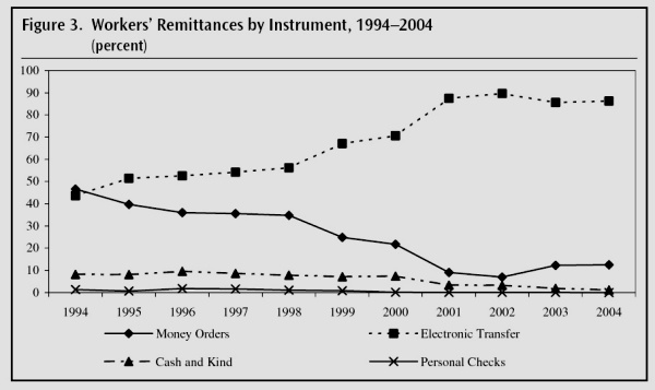
Trends in methods used for remittance transfers. Credit: World Bank, 2005

Trends in methods used for remittance transfers. Credit: World Bank, 2005

The statistics for the value of remittances are based largely on formal transfers. One clear trend, reflected in data from Mexico’s central bank (Banxico), is that migrants are increasingly choosing to send funds using direct electronic transfers (see graph), rather than by personal checks or money orders.

In a future post, we will try to answer the question, “What factors affect migrants’ decisions about the best way to send their money back to Mexico?”

Related posts:

The rapid expansion of literacy and education in Mexico

 Updates to Geo-Mexico  Comments Off on The rapid expansion of literacy and education in Mexico
Nov 282011
 

Data from Mexico’s 2010 census indicate that considerable progress has been made in the recent past. Literacy of those over age 15 has increased from 87.6% in 1990 to 90.5% in 2000 and 93.1% in 2010. This is to be expected since literacy varies with age. As the older people, many of whom are illiterate, die off, they are replaced by younger, more literate, Mexicans. For example, in 2010, 34% of those over age 75 were illiterate, compared to under 2% for those aged 15 to 29.

Literacy is highest in the Federal District (97.9%) and lowest in Chiapas (82.2%), Guerrero (83.3%) and Oaxaca (83.7%). In future decades, illiteracy will continue to decline significantly, especially in the poorer southern states. However, with life expectancy increasing and older people living longer, illiteracy will not decline as fast as it might.

Preschool, primary schools (primaria) and junior high schools (secundaria)

educationAbout half of Mexican children aged 3 to 5 attended preschool in 2010. Basic education begins with primary schools (primaria) with grades 1 to 6 for children generally between the ages of 6 and about 12. Junior high schools (secundaria) cover grades 7 to 9 and focus on 12 to 15-year-olds. In Mexico primaria and secundaria are compulsory; however, in the past, many children dropped out for a wide variety of reasons (the need to work and support the family being a major one). Mexico’s telescundaria system brings junior high school lessons to students in remote areas via satellite.

In 2010, an impressive 95% of those aged from 6 to 14 attended school, compared to 91% in 2000 and 86% in 1990. The majority of the 5% not attending school in 2010 did attend school previously and had acquired basic literacy. The rather poor state of Hidalgo had the highest attendance rate in 2010 with 96.4% (tied with Tlaxcala and the Federal District). The lowest levels were in Chiapas (90.8%), Michoacán (92.4%) and Guerrero (93.1%).

The rather small difference between the highest and lowest rates suggests that most Mexicans throughout the country have relatively equal access to basic education. Even in the poorest 125 of Mexico’s 2442 municipalities 88% of 6 to 14-year-olds were in school, according to the 2010 census.

High or senior high schools (preparatoria)

Senior high school education (prepatratoria) offers grades 10 to 12 and is not compulsory. Students generally are aged between 15 and 18. Some of these schools focus on preparing students for university while others focus on vocational training. In some rural areas, students must travel considerable distances to the nearest senior high school, and some have to live away from home during term time.

Teaching hours and the quality of education

Unfortunately, school attendance is not a reliable indicator of the number of teaching hours. Students receive only 2.8 hours of real instruction per day according to a new study by Mexicanos Primero, a citizens’ group focused on improving the quality of education. The study indicates that Mexican students get 562 hours of instruction per year, compared to 710 hours in the USA, 875 in France, 1172 in Finland and 1195 in South Korea. Mexicanos Primero complains that too much real instruction time is lost due to preparation for parades and festivals, teacher absenteeism and school closures.

There are also issues concerning the quality of education. According a recent Organisation of Economic Cooperation and Development (OECD) Mexico is doing a poor job of educating its youth. Only 1% of Mexican 15-year-olds have the knowledge and skills needed for full participation in modern society, compared to 30% in Hong Kong and 26% in South Korea.

Higher education has made impressive gains. In 2010 over 40% of those aged 15 to 24 were attending school compared to 33% in 2000 and 30% in 1990.

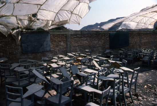
temporary classroom

Temporary classroom while a new school is being built. (Jungapeo, Michoacán, mid-1980s). Photo: Tony Burton.

Years of schooling

The “average years of schooling” figure has increased about one year a decade, from 6.5 years in 1990 to 7.5 in 2000 and 8.6 in 2010. The Federal District is the most educated with an average of 10.5 years of schooling, compared to 6.7 in Chiapas and 6.9 in Oaxaca. Given historical trends, older adults have significantly fewer years of education than younger adults.

There are still some serious urban-rural differences. The best educated municipality is Benito Juárez in the Federal District with 13.9 years, compared to levels between 2.3 and 3.4 years for the ten lowest municipalities, which are all in the rural south and are predominately indigenous language speakers. In these poor indigenous rural municipalities, most of the elderly have virtually no schooling even if the majority of children are now attending school and learning Spanish.

Source:

Unusual hazard: gasoline pours out of storm drains in Poza Rica, Veracruz

 Mexico's geography in the Press  Comments Off on Unusual hazard: gasoline pours out of storm drains in Poza Rica, Veracruz
Nov 262011
 

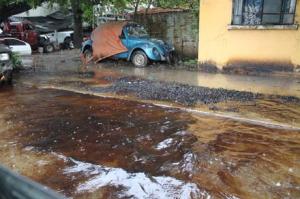
Recent floods in parts of the city of Poza Rica (Veracruz) resulted in an unusually dangerous situation. As groundwater rose following exceptionally heavy rains, a mixture of water and oil flowed out of some street drains.

street awash with oil photo

A Poza Rica street awash with oil and water. Credit: La Voz del Sureste

The precise cause is unknown. The city is blaming the state oil giant Petroleos Mexicanos (Pemex). Pemex claims that the hydrocarbons are natural tar, deposits of which underlie some parts of the region.

Whatever the cause, the flooding resulted in extremely hazardous conditions in the Chapultepec colonia, where Ébano, Nogal, Chopo, Eucalipto, Ciprés, Fresno and Sabino streets were badly affecfed, and in the Cazones colonia, where the aptly-named Pozo 13 (Well 13) was awash with oil. The mayor of Poza Rica was quoted as saying that “The rivers of crude left parked cars completely covered.”

Families living in the affected areas were evacuated temporarily for their own safety. Fortunately, local authorities, assisted by Environmental Protection officials and Pemex experts, were able to quickly bring the situation under control, without any loss of life or serious injuries.

Sources:

  • Brota hidrocarburo de drenajes en Poza Rica (Diario La Voz del Sureste online)
  • Concluyen limpieza de derrame de hidrocarburo en Poza Rica (xeu.com.mx)


Many states in Mexico badly affected by drought

 Mexico's geography in the Press, Updates to Geo-Mexico  Comments Off on Many states in Mexico badly affected by drought
Nov 232011
 

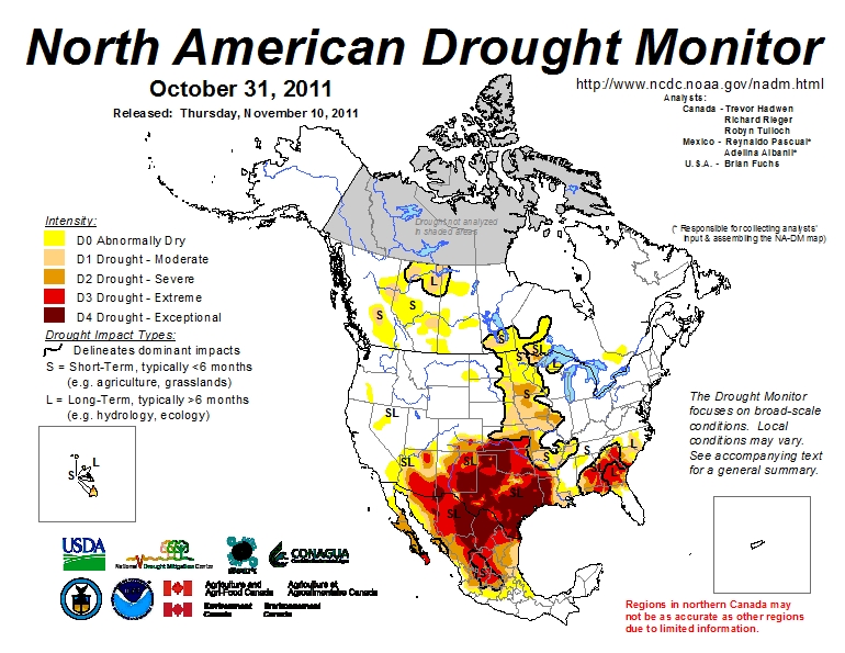
Much of Mexico is currently affected by some degree of drought (see map below). The National Meteorological Service (SMN) reports that September was one of the driest months in some 70 years. All the signs suggest this is the worst year for drought since 1941. The worst affected states are Sonora, Chihuahua, Coahuila, Durango, Nuevo León and Zacatecas. (Paradoxically, some parts of southern Mexico, especially in the states of Oaxaca and Tabasco, have experienced serious flooding in recent months).

In the drought zones, emergency programs are getting underway to provide temporary work for many rural dwellers and to supply potable water to the worst affected settlements. In addition to crop losses, up to one million head of cattle will have been put down by year-end in northern states as a direct result of the drought, since farmers do not have sufficient fodder available to feed them as usual.

While some cattle have been exported to the USA, local meat prices will be driven down by the increase in supply, making many farmer’s livelihoods even more precarious. Many farmers will need federal assistance to overcome this latest crisis.
Areas suffering from drought, October 2011

Areas suffering from short-term and long-term drought, October 2011. Click map to enlarge

Durango faces the worst drought for 100 years

In Durango, water has been provided to 32,691 residents in 10 municipalities, with another 36 municipalities to be supplied in the current phase of emergency assistance. Officials in Durango say it is the state’s worst drought for 100 years, with most larger reservoirs in the state now holding between 20% and 40% of their capacity; one reservoir is already down to less than 10% of its.

Irregular rains over the past few months have done little to replenish reservoirs, leaving farmers in despair. The long-range forecast does not appear to offer them much consolation, with the drought expected to last well into next year.

By mid-September, some parts of Durango had received less than 140 mm of precipitation so far ths year, well below the 425 mm registered for the same period in 2010.  The only hope for local farmers appears to be if late season hurricanes bring far more rain than expected to this region.

The drought news from other states

In Chihuahua, 589 tankers have delivered water to settlements housing 62,000 in 15 different municipalities: Guazapares, Janos, Manuel Benavides, Morelos, Moris, Ocampo, Ojinaga, Urique, Uruachi, Aldama, Balleza, Bocoyna, Guachochi, Guadalupe and Calvo.

In Zacatecas, a “state of emergency” has been declared for 52 of the state’s 58 municipalities. More than 150 communities are seriously affected, especially smaller communities in the municipalities of Fresnillo, Jerez, Guadalupe, Tlaltenango, Nochistlán, Atolinga, Villa de Cos, Genaro Codina and Teúl de Gonzalez Ortega.

Drought has affected 288,000 hectares of rain-fed crops in Guanajuato. The greatest losses are of corn, beans, wheat, sorghum and other grains, with the worst-hit areas located in the northern part of the state. More than a million liters of potable water have been supplied to 18,000 inhabitants living in 133 settlements in the state, located in the municipalities of Atarjea, Doctor Mora, San Diego de la Unión, San Felipe, Santa Catarina, Tierra Blanca, Victoria and Xichú.

Horticulturalists in Sinaloa growing vegetables, grains and fruit for export want 30 million dollars in emergency funds to restore irrigation to 700,000 hectares of productive land. More than 200,000 seasonal jobs are at risk.

Related post:

Mexico’s water resources and water-related issues are the subject of chapters 6 and 7 of Geo-Mexico: the geography and dynamics of modern Mexico. Ask your library to buy a copy of this handy reference guide to all aspects of Mexico’s geography today! Better yet, order your own copy…


Mexico reduces emissions with innovative carbon credit project

 Mexico's geography in the Press  Comments Off on Mexico reduces emissions with innovative carbon credit project
Nov 212011
 

Mexico is rapidly becoming a key market for environmental investments, and now accounts for one in every five projects involving Clean Development Mechanisms (CDMs) in Latin America. A recent Reuters news item gives the basic details of one CDP project:

  • Mexico to earn royalty on light bulb carbon credits

CDMs, established after the Kyoto Protocol, allow companies in developing countries to sell Certified Emission Reduction certificates (CERs) to buyers in industrialized countries, to offset their own emissions control targets. The certificates prove that there has been a reduction in greenhouse gas emissions.

One project involving CERs, started by Australian company Cool nrg International, will reduce Mexico City’s carbon dioxide (CO2) emissions by 16 million tonnes over the next 10 years. The company is distributing 30 million free energy-efficient lightbulbs to 6.5 million low-income households, which will save 33,000 gigawatt hours of electricity.

Watch Nick Francis from Cool nrg explain the plan and why it is a win-win-win for everyone concerned:

Every tonne of CO2 saved generates a CER credit (currently trading at 9 dollars). For every credit, Mexico receives a royalty payment. Cool nrg then sells the CERs to companies in industrialized countries. The project is a world first and its success will be closely monitored by many other countries.

Related posts:


Mexico, USA and Canada cooperate to produce monthly drought maps

 Books and resources  Comments Off on Mexico, USA and Canada cooperate to produce monthly drought maps
Nov 192011
 

The North America Drought Monitor (NADM) is a “cooperative effort between drought experts in Canada, Mexico and the United States to monitor drought across the continent on an ongoing basis”. The program began  in 2002 . The NADM is an extension of an earlier version that was limited to the USA.

The NADM combines multiple indices and local information to produce “drought monitor” maps that best reflect the consensus of numerous scientists, some working at state or federal level, and others working in tertiary education and research.

What exactly is a “drought”?

The basic definition of a drought is a prolonged period of abnormally low precipitation. In practice, this means a period when precipitation is significantly less than would normally be expected for the time period under consideration. The amount of precipitation that is “normal” varies greatly from one area to another, and can also vary with the seasons. Low precipitation in a desert would not necessarily indicate a drought! On the other hand, low precipitation in a rainforest almost certainly would indicate a drought. Since most of Mexico experiences a dry season and a rainy season each year, this further complicates the picture. Not only is it important to know how much precipitation falls, but it is also important to know when it falls.

Areas suffering from drought, October 2011
Areas suffering from short-term and long-term drought, October 2011. Click map to enlarge

This definition must be borne in mind when looking at the Drought Monitor maps, as should the seasonality of precipitation throughout most of Mexico, and the distribution of precipitation, which varies greatly from north to south.

The NADM maps show that the drought situation can change quite rapidly from one month to the next. (Use the link above to compare February and March 2011, for example, or March and April 2011).

In a future post, we will take a closer look at the impacts of the drought (shown on the map) that currently affects much of northern Mexico.

Nov 162011
 

Mexico may have major reserves of petroleum but it lacks the necessary refining capacity to supply the domestic market with all the refined products such as vehicle fuels that its industrial, commercial and residential sectors demand.

As a result, Mexico has to import refined petroleum products, mainly from the USA. The high costs of these imports is a constant point of discussion in Mexico. If the country developed sufficient refining capacity, it could spend every dollar that currently goes on petro-based imports on something else, such as social services or infrastructure improvements.

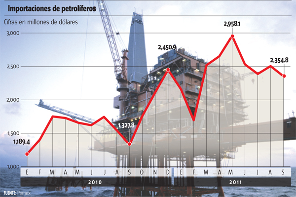
Pemex imports. Credit: milenio.com
Pemex imports, by month. Figures in millions of US dollars. Credit: milenio.com

A small fortune is being spent each month on petroleum-related imports (see graph). Over the past year, the cost of imports has risen 12.3%. This is almost entirely due to higher oil prices on international markets; the volume of imports has increased only 1% over the period.

Imports of refined petroleum products will not end any time soon. Mexico does plan to build new refineries and expand its refining capacity, but they will take years to complete. Earlier this year, it was reported that Pemex engineers were adding the final touches to the blueprints for a new refinery in Tula (Hidalgo). Work began with the re-routing of existing irrigation channels and high tension power lines to take them well away from the site. It remains unclear, though, just how long it will take for this project to be completed.

Related posts:


Nov 142011
 

A few months back, we wrote of the conflicts surrounding the proposed tourist mega-development near Cabo Pulmo. The controversial plans for Cabo Cortés involve building on the virgin sand dunes, and will undoubtedly have adverse impacts on the small village of Cabo Pulmo and the ecologically-sensitive Cabo Pulmo National Marine Park and its coral reef.

Later, we followed up with an in-depth look at how the establishment of a Cabo Pulmo Marine Park had led to an astonishing recovery of the area’s biodiversity:

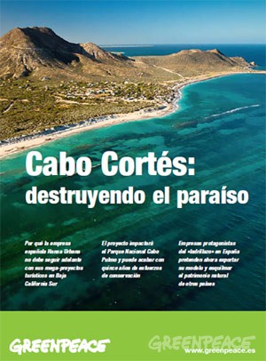
Cover of Greenpeace's position paper on Cabo Cortés

"Cabo Cortés: destroying paradise" (Greenpeace)

This story, which essentially pits mass tourism against ecotourism, continues to attract lots of media attention. The latest major article is Plans for resort in Mexico ignite concern about reef, published in The Washington Post. The article looks at the Spanish companies involved in the ownership and construction of the proposed resort and quotes the opinion of local people who hope that the economic crisis in Europe will put an end to their grandiose plans.

The Spanish firms involved are “ailing Spanish development conglomerate” Hansa Urbana, which bought the meg-development site in 2007, and a  savings bank called CAM (Caja de Ahorros del Mediterraneo), which lent Hansa millions of dollars.

Later, Hansa gave CAM the property in exchange for having its debt wiped clean. CAM has since been bailed out to the tune of $3.8 billion by the Bank of Spain, in which the Spanish government has a controlling interest. The Bank of Spain plans to auction CAM, but only after the upcoming Spanish elections.

As a result, and as the Washington Post article makes clear, “environmental activists are not even sure who controls the resort project anymore.”

Mexico’s federal Environment and Natural Resources Secretariat (Semarnat) originally gave Spanish firm Hansa Urbana the green light to begin construction, but now say that construction can only begin if the developers can prove that the reef will remain unharmed.

Mexican authorities are reported to be consulting with “expert marine biologists and U.N. officials”:

  • Misión conjunta de la UNESCO y Ramsar visitará Cabo Pulmo la próxima semana
  • La UNESCO visitará Cabo Pulmo

The government has set a deadline of January 2013 for the submission of a detailed report showing that construction will not cause any environmental damage to the Marine Park.

The deadline comes only a month after President  Calderon leaves office, which, as many locals realize, could be very unfortunate for the future welfare of the reef and local ecotourism activities.

The diffusion of violence in Mexico since the early 1980s

 Mexico's geography in the Press  Comments Off on The diffusion of violence in Mexico since the early 1980s
Nov 122011
 

Today, we take a quick look at Mexico, the Un-Failed State: A Geography Lesson, published on the InSight Crime website. InSight Crime’s stated objective is “to increase the level of research, analysis and investigation on organized crime in Latin America and the Caribbean.”

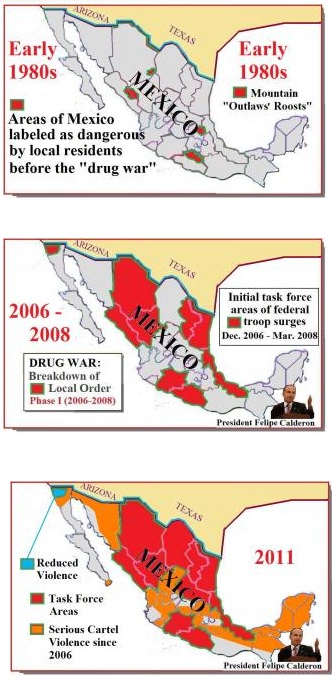
diffusion of violence in Mexico

Credit: InSightcrime.org

Gary Moore, the author of Mexico, the Un-Failed State: A Geography Lesson, considers some of the claims made recently about Mexico being a “failed state”, where parts of the country are effectively no longer under government control. As the title of article suggests, Moore does not find evidence to support these claims.

His position is set out early in the article when he writes that, “The statements are all serious assessments of an elusive reality. The violence in today’s Mexico forms a twilight zone. It is not an all-consuming apocalypse, but it is also not the relative peace of Mexico a generation ago.”

The article is illustrated by three maps, “snapshots” of the situation in the early 1980s, in 2006-2008 and in 2011. While these appear to show that there has been a significant expansion of violence across Mexico in recent years, some caution is needed since the evidence used for each map is entirely different.

Moore’s article is a useful overview of how and why violence has diffused across much of Mexico since President Felipe Calderón declared a “war on drugs” in December 2006. It is, though, only an overview. There are significant local differences even within those states (such as Tamaulipas and Chihuahua) which are considered to be among the worst for drug violence in the country.

Few analysts would disagree with the article’s concluding statements that:

“In the 1970s it was natural to assume that these throwback “bandido” areas were shrinking and would soon disappear, as the march of development brought education, opportunity and civilization.”

“The harsh news from the drug war is that the reverse has occurred. The landscape of no-go zones has swelled across Mexico, as at no time since the Mexican Revolution of 1910-1920.”

The Mexican Revolution threw Mexico into convulsions for more than a decade, and the war on drugs looks set to last at least as long.

Related posts:


Where are the wealthiest households in Mexico?

 Other  Comments Off on Where are the wealthiest households in Mexico?
Nov 102011
 

A recent publication from the public opinion research consultancy Mitofsky offers some insights into the distribution of different socio-economic groups within Mexico.

The Mitofsky study relies on the AMAI 10×6 system to tabulate the percentage of households in each state that fall into six distinct categories: A/B, C+, C, D+, D and E.

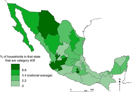
Across Mexico as a whole, 4.4% of households are categorized as A/B (the highest category, see map below), 12.3% as C+, 17.9% as C, 39.1% as D+, 21.6% as D and 4.7% as E (the lowest category).

The data show that, between them, four states–the Federal District (23.4% of all A/B households in Mexico), Jalisco (14.4%), State of México (9.3%) and Nuevo León (5.9%)– account for more than half of all the homes in this category in Mexico

The map shows how the incidence of A/B households (the highest socio-economic category) vary, state by state, across the country.

Distribution of highest socio-economic status households in Mexico.
Households in the highest socio-economic group in Mexico. (Geo-Mexico/Tony Burton; all rights reserved)

Do you live in an A/B household?

1. Housing characteristics:
– average of 6-8 rooms (often 3 bedrooms, 3 bathrooms) built of brick and/or concrete
– floors tiled, hardwood or stone; more likely to have carpets or rugs than lower categories
– most are owner-occupied, not rented

2. Sanitary Infrastructure
– connected to municipal potable water and sewer systems
– all have tub, shower, and water heater (usually using gas)
– two-thirds of these homes have water cisterns and pump to supply water tanks.
– some have air conditioning and/or central heating

3. Practical Infrastructure
– average 2 vehicles
– all have stoves, refrigerators and washing machines
– almost all have microwave ovens, blenders, toasters, coffee-makers and juice extractors

4. Communications and Entertainment Infrastructure
– almost all have fixed line telephones and cell phones
– most have 3 or 4 TVs and  satellite or cable TV
– all have DVDs and stereos/CD players; half have video game consoles
– average more than 1 computers per household; 75% connected to Internet
– many have memberships of private sports clubs and own a second home or time-share.
– more than 50% have traveled by air at least once in last 6 months, and most travel overseas at least once a year

5. Educational and Occupational Profile of Head of Family
– usually has a bachelor’s degree or higher
– work in medium or large companies, as directors, CEOs or other high-ranking professionals

6. Expenditures
– these households save more, but also spend more on education, entertainment, communication and vehicles
– food purchases account for only 7% of total expenditures, well below the average for the total population
– of these food purchases, the proportion spent on dairy products, fruit, and drinks is greater than lower categories

Questions worth thinking about:

  • How does this map compare to other maps on Geo-Mexico of inequalities across the country? (Use the site search feature or tags from the tag cloud on the left hand side of each page to find other inequality maps)
  • To what extent does this map confirm that north-south divide described in several previous posts?

Source:

Niveles socioeconómicos por entidad federativa 2009 – 2010 by Roy Campos and Ana María Hernández; CONSULTA MITOFSKY, December 2010.

Related Posts:

Mexican migrants and remittances: an introduction

 Books and resources, Index page  Comments Off on Mexican migrants and remittances: an introduction
Nov 072011
 

Remittances (the funds sent by migrant workers back to their families) are a major international financial flow into Mexico. Remittances bring more than 20 billion dollars a year into the economy, an amount equivalent to 2.5% of Mexico’s GDP.

On a per person basis, Mexico receives more worker remittances than any other major country in the world. An estimated 20% of Mexican residents regularly receive some financial support from relatives working abroad. Such remittances are the mainstay of the economies of many Mexican families, especially in rural areas of Durango, Zacatecas, Guanajuato, Jalisco and Michoacán.

The causes and consequences of mass out-migration and large remittance payments are varied, and sometimes disputed. For background, causes and trends, try:

For some impacts of Mexican migrants on the USA (of varying importance), see:

The four subtitles used in the Atlantic Magazine article are useful reminders of some of the other major aspects of international migration from Mexico. Again, links are given to previous Geo-Mexico posts which look at good examples.

“Branching Out” emphasizes the links that exist between communities, often referred to as “migration channels”.

“The Hollow States” identifies the five major “states of origin”—Guanajuato, Jalisco, Michoacán, San Luis Potosí and Zacatecas—which receive almost 50% of all remittance payments.

“Staying Put” points out that improved economic conditions in Mexico in recent decades, have restricted out-migration from certain areas, especially the border region. Recent developments in Mexico’s war on drugs have, however, led to an increase in the number of border residents moving to bigger, safer cities further south, or seeking to emigrate to the USA.

“Community Development” stresses the important link between “hometown associations” (groupings, found in many US cities, of Mexican migrants sharing a common area of origin) and their related villages and towns in Mexico. Many community development projects in areas of high out-migration have been financed by remittances. In many cases, the three levels of Mexican government—municipal, state and federal—provide matching funds for such projects, meaning that remittances only pay for 25% of the total costs.

In future posts, we will examine some of these aspects of remittances in more detail, and take a much closer look at the precise mechanisms used to make the international financial transfers involved.

Mexico’s freshwater aquifers: undervalued and overexploited

 Excerpts from Geo-Mexico  Comments Off on Mexico’s freshwater aquifers: undervalued and overexploited
Nov 052011
 

Mexico’s groundwater aquifers are a very important resource. About 64% of public water supplies come from wells sunk into aquifers. Mexico City, Monterrey and several other metropolitan areas rely heavily on aquifers. Aquifers also provide about one-third of all the water for agriculture and livestock.

The largest aquifer resource in terms of renewable water availability is in the Yucatán Peninsula, with about a third of the national total. A large portion of the rainfall in the Yucatán seeps into its aquifers; there are virtually no rivers to carry rainwater to the ocean. The states of Chiapas and Tabasco, where rainfall is the heaviest, account for about a quarter of Mexico’s aquifer resource. The next largest sources are the Balsas and Lerma–Santiago basins but each holds less than a tenth of the national total.

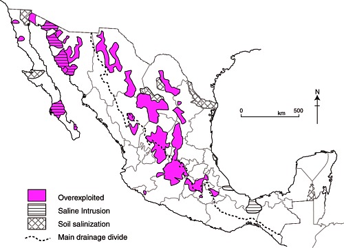
Map of overexploited aquifers and areas of salinization

Overexploited aquifers and areas of salinization (Fig 6-7 of Geo-Mexico; all rights reserved)

According to the National Water Commission, 104 of the country’s 653 identified aquifers are overexploited in that more water is withdrawn each year than is naturally replaced. The velocity of water movements underground can be astonishingly slow; it may take rainwater water tens or even hundreds of years to reach the aquifer it is replenishing. (For a curious case of replenishment rates, see The Enchanted Lake).

The number of overused aquifers has increased rapidly in recent decades from 32 in 1972, to 80 in 1985, and 104 in 2004. When coastal aquifers are over-exploited, seawater seeps in to replenish the aquifer, and eventually the aquifer can become too salty to be used for irrigation. Salt-water intrusion is a significant problem for 17 aquifers located in Baja California, Baja California Sur, Colima, Sonora and Veracruz (see map).

Nearly 60% of the total groundwater extracted is withdrawn from overexploited aquifers. As expected,  the over-exploited aquifers are in the heaviest populated and the most arid areas. Total water extraction exceeds recharge in Mexico City, Monterrey and other large northern metropolitan areas as well as irrigated areas of Sonora, the central northern plateau, the Lerma basin and Baja California.

Related posts:

Mexico’s water resources and water-related issues are the subject of chapters 6 and 7 of Geo-Mexico: the geography and dynamics of modern Mexico. Ask your library to buy a copy of this handy reference guide to all aspects of Mexico’s geography today! Better yet, order your own copy…

Mexico Pan-American Highway, route of one of the toughest road races in the world

 Other  Comments Off on Mexico Pan-American Highway, route of one of the toughest road races in the world
Nov 022011
 

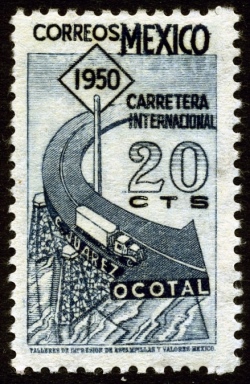
The completion of the Mexican stretch of the Pan-American Highway, from the US border to Guatemala, in the late 1940s was a significant turning-point in the development of Mexico’s road network. The highway made previously remote areas more accessible, but, far more than that, it served as a symbol of unity and Mexico’s progress into the modern era. Only a few years later, the total length of federal highways exceeded the total combined length of the country’s railway lines. As highway transport of freight and passengers took over, rail transport never fully recovered.

To celebrate the opening of the Pan-American Highway, in 1950 a major road race was organized: the Pan-American Race (Carrera Panamericana). The race was held annually until 1954, after which authorities claimed that it had achieved the desired publicity. Actually, the race had achieved considerable undesired publicity as one of the world’s most dangerous road races, 27 people having lost their lives in five years the race was held.

The race was revived, but as a modern, shorter version arranged as a stage rally for vintage cars, in 1988. The 2011 race has just finished.

7 days, 100 cars, 3,000 km, one crazy race (Globe and Mail)

Racers in the early 1950s achieved some astounding average speeds, up to 135 mph for an entire stage. The following extract from a contemporary news report tells the story:

“The 3114 km Mexican road that stretches south to north from Tuxla to Juárez is, according to Alfred Neubauer [a legendary Mercedes-Benz Competition director], a combination of Tripoli’s Grand Prix, the Italian Mille Miglia, the German Nurburgring, and the Le Mans 24 hrs….

The race begins in a tropical climate where the temperature is high and humid and continues along a road that goes from sea level to a suffocating 3000 meter altitude! Temperature variations go from 34 Celcius to almost 2 degrees above freezing in just 72 hours… Carburetors and spark plug selection need alterations every 160 km approximately. Motors that ran miraculously at 1000 mts sounded almost dead at 3000….

The road is paved with a mixture of volcanic ash and this highly abrasive substance will turn a perfectly new passenger car tire to a worn-out one in a 1000 km distance.”

The current road network in Mexico is extensive, covering virtually all areas of the country. Mexico has over 120,000 km of paved roads, far more than any other country in Latin America. By contrast, Brazil has about 96,000 km. There are over 10,000 km of controlled access toll expressways (even if they are among the most expensive in the world!). There are an additional 10,000 km of free four lane highways. Mexico also has over 200,000 km of unpaved roads.

Want to read more?

Uxpanapa, an example of forced migration

 Excerpts from Geo-Mexico  Comments Off on Uxpanapa, an example of forced migration
Oct 312011
 

Almost all internal migration in Mexico in recent history has been voluntary. Tens of thousands of rural Mexicans have decided that life might be better somewhere else and have left their farms for the bright lights of the nearest large city. Their motivation is usually economic, but sometimes may be based on educational opportunities or access to health care.

However, not all internal migration has been voluntary. There have been some cases of forced migration, where the inhabitants of a village or area have been made to move away in order to make way for large-scale infrastructure projects such as reservoirs, tourism resorts and hotel complexes.

Since most good dam sites are in remote highland areas, with sparse population, forced migrations due to new dams are relatively rare in Mexico. One good example is when the building of the Cerro de Oro dam in the 1970s in northern Oaxaca, on a tributary of the River Papaloapan, flooded 360 square kilometers (140 square miles) and meant the forced relocation of more than 5000 Chinantec Indians. [Aguilera Reyes] The resettlement plan was one of the most forward-looking of its time. Villagers received compensation for their existing homes, trees and crops, and were offered a choice of possible resettlement sites.

They chose an area of rainforest-covered ridges and valleys near the headwaters of the Rivers Coatzacoalcos and Uxpanapa in the Isthmus of Tehuantepec. With government assistance they built a dozen new villages named, somewhat unimaginatively, Poblado Uno, Poblado Dos, etc. Extensive agricultural support was provided for several seasons, but the plan failed to live up to expectations, in part because its architect, the distinguished Mexican geographer Jorge Tamayo, was killed in a plane crash in 1978.

Many of the area’s young people have migrated (voluntarily) north. The remaining villagers grow ixtle, a fibrous cash crop produced from rainforest bromeliads that can be used for ropes and belts. They are also trying to introduce ecotourism to preserve what is left of their tropical jungle hideout, which has a rich biodiversity, including spider monkeys and jaguars. [Ginsberg]

References:

Aguilera Reyes, S. 2004 “Desarrollo, Población y Uso de los Recursos Naturales en el Valle de Uxpanapa.” Universidad Veracruzana Facultad de Sociología thesis. Xalapa,Veracruz. Marzo 2004.

Ginsberg, S. 2000 Report from Uxpanapa. Can bromeliads save Veracruz’s last rainforest? [6 September 2009]

Related posts:

This post is an edited excerpt from chapter 25 of Geo-Mexico: the geography and dynamics of modern Mexico. Buy your copy today!

Food speculation fuels a tortilla crisis in Mexico

 Books and resources, Teaching ideas  Comments Off on Food speculation fuels a tortilla crisis in Mexico
Oct 292011
 

The Ecologist Film Unit has produced an excellent 8-minute video on how financial speculation on corn (maize) has led to a dramatic rise in the price of corn tortillas, with potentially disastrous effects for the health and well-being of the many of Mexico’s poorest. Reporter Tom Levitt’s video, accompanied by text, presents a compelling case, one which would be an excellent starting-point for class discussions.

Two short quotes set the scene:

“For many Mexicans, particularly the estimated 40 million living on less than $5 a day (£3), tortillas account for almost half of their average daily calorie intake. As a whole, the country consumes 23 times more maize than rice.”

“In 2000 there was $6 billion invested in commodities, by 2011 it was $340 billion, of which $126 billion, according to data from Barclays Capital, is reported to be invested in food. The vast majority of this new investment has been by speculators with no interest in the agricultural sector or in actually taking delivery of the commodity.”

The result? Higher prices for corn, greater unpredictability in prices, and adverse changes to the diet of tens of thousands, as corn becomes more expensive than meager household budgets permit.

The video is a powerful indictment of the harm being done to ordinary people in many parts of the developing world by rich-world market speculators and investment banks. Watch it now, or read the full article:

Mexico adds three more Magic Towns to its list

 Mexico's geography in the Press  Comments Off on Mexico adds three more Magic Towns to its list
Oct 272011
 

Mexico’s Magic Town (Pueblo Mágico) program seeks to promote inland destinations that offer a complementary tourism based on historic and cultural attributes. The federal Tourism Secretariat has announced there will be 52 Magic Towns by 2012, when the promotional program is currently due to end. As many as 70 towns are reported to be seeking accreditation as Magic Towns. Some of these applicants are likely to join similar promotional groupings such as “Pueblos con Encanto” (Towns with Charm) and “Pueblos Señoriales” (Noble Towns).

Mexico currently has 44 Magic Towns:

The three latest towns to be added to the list are:

Magic Town #42: Mineral del Chico (Hidalgo)

Mineral del Chico is a small town (population 6700 in 2005; altitude 2351 m) at the entrance to the El Chico National Park in Hidalgo. The National Park, with its forests, mountains and waterfalls, is much better known than the town itself. This was the one of the earliest forested areas to be officially protected in Mexico. It was declared a Forest Reserve in 1898 and became a National Park in 1922.

Magic Town #43: Cadereyta (Querétaro)

The designation of Cadereyta as a Magic Town creates a great multi-day tourist trip including two other Magic Towns: Bernal and Jalpan de Serra. Cadereyta is known for its noisy and ebullient Holy Week (Semana Santa) processions, a tradition said to date back to the 18th century. The town has several interesting churches and two genuine colonial treasures. The gilded retable of the church of San Pedro and San Pablo has to be seen to be believed.

  • Tourism attractions of Cadereyta
  • Two colonial treasures of Cadereyta

Magic Town #44: Tula (Tamaulipas)

Close to the northern border, Tula, founded in 1617, is the oldest still-inhabited settlement in the state of Tamaulipas. The town has several colonial buildings but is best known for making elaborate leather jackets (cuera tamaulipeca), first designed in the 1950s.

These three latest newcomers all have their attractions, but, at least in my humble opinion, are not in the same league in terms of their historical and tourist interest as most previously-designated Magic Towns.

Related posts:

Gulf of Mexico energy reserves: updates in Mexico’s oil and gas sector

 Mexico's geography in the Press  Comments Off on Gulf of Mexico energy reserves: updates in Mexico’s oil and gas sector
Oct 252011
 

PEMEX awards first-ever contracts for the operation of oil fields.

In a move welcomed by international oil analysts, Pemex has awarded British company Petrofac Facilities Management Ltd. a contract to operate the Santuario oil fields in Tabasco. Prior to this contract, all oil field operations in Mexico since 1938 had been directly managed by Pemex.

Operations in two other areas – Magallanes and Carrizo – are also being contracted out. The areas cover 312 square kilometers between them, and have 3P (proven, probable, possible) reserves totaling 207 million barrels of crude oil equivalent. The contractual changes should attract considerable foreign investment in coming years, and are expected to play an important role in boosting national oil production from its current level of 2.5 million barrels a day.

Major natural gas discovery in the Gulf of Mexico

Pemex has announced that its Piklis 1 offshore well, located 150 km northwest of Coatzacoalcos in the Lakach field, has found a massive deposit of natural gas 5,431 meters below the water surface. The deposit holds more than 400 billion cubic feet of gas and, when production begins in 2014, it should yield 700-800 million cubic feet/day, reducing Mexico’s natural gas imports by up to 80% over the next 15 years. Compared to 2009, Pemex’s total revenues in 2010 rose 20.3% to 115 billion dollars, mainly due to high prices for petroleum and related products; export sales were 21.4% higher. Pemex is currently producing about 2.6 billion barrels of crude oil/day.

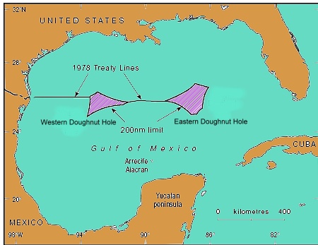
location of doughnut holes

How much does it cost to produce a barrel of oil?

According to Mexico City daily La Jornada, Pemex has maintained its enviable low costs per barrel of oil obtained (all figures in dollars):

  • 2006 $4.40
  • 2007 $4.90
  • 2008 $6.10
  • 2009 $4.90
  • 2010 $5.20

These costs per barrel are very competitive, and well below the costs recorded for other major firms as Total, BP, Exxon, Statoil, Chevron and Petrobras, who have production costs of between $6.10 and $10.00 a barrel.

Transborder oil fields

Several major oil and gas fields are known to straddle the international border in the Gulf of Mexico. Deepwater wells on the US side have already found massive deposits of oil, but, until recently, Pemex has not had the technology to drill in such deep waters. That is now changing. Pemex has begun drilling from the deepwater “Bicentenario” semi-submersible platform. The first well, Talipau-1, will descend 940 meters to the sea floor and then a further 5,000 meters into oil-bearing strata in the region known as the Cinturón Plegado de Perdido.

Pemex believes that deepwater wells in the Gulf of Mexico will eventually yield several billion barrels of oil.

The Bicentenario, built in South Korea, is capable of operating in water up to 3,000 meters deep; it is 100 meters in length, 78 meters wide and rises 138 meters above the surface, with a total weight of 58,000 metric tons. It will house up to 160 workers at a time.

In related news, bilateral talks were held in Washington DC at the end of August relating to offshore oil fields that straddle the Mexico-USA maritime boundary in the Gulf of Mexico. The talks will set the parameters for efficient and safe exploitation of these hydrocarbon reserves in the future. A formal agreement is expected to be completed before the end of this year.

Related posts:

Veracruz: one of Mexico’s most diverse states

 Other  Comments Off on Veracruz: one of Mexico’s most diverse states
Oct 242011
 

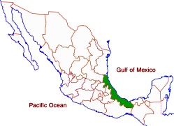
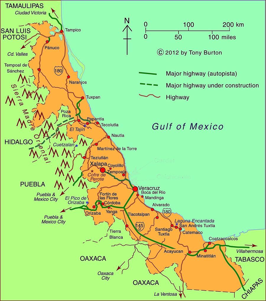
Veracruz, one of Mexico’s most important and interesting states, is a narrow strip of land stretching for 650 kilometers (over 400 miles) along the Gulf of Mexico. The topography ranges from a narrow coastal plain to very high mountains on its western border including Mt. Orizaba, Mexico’s highest peak at 5,610 meters (18,406 ft.).

The relief helps to funnel migrating birds into a narrow band across the state:

Veracruz which is one of the rainiest states has three of Mexico’s five largest rivers: the Panuco in the north and the Papaloapan and Coatzacoalcos rivers in the south. Its varied climate and ecosystems mean enormous biodiversity, including species of insects, birds and plants that exist nowhere else on earth. These species are protected in 31 protected areas including three national parks. Previous posts describe the fabulously beautiful Las Tuxtlas Biosphere Reserve and the mysterious Laguna Encantada.

With over 7.6 million residents, Veracruz trails only the State of Mexico and the Federal District in population. While the state is over one-third rural, it has several major metropolitan areas. The state capital is Xalapa (809,000). Other major cities include the industrial twin cities of Coatzacoalcos (234,000) and Minatitlán (356,000) in the extreme south, and the port city of Veracruz (703,000) in the center. The north of the state is served by the port city of Tampico (803,000) on the north bank of the Panuco River in the neighboring state of Tamaulipas.

One of the most interesting towns is Yanga, which was established around 1570 by escaped slaves lead by Gaspar Yanga. The town, the first African-ruled settlement in the New World, successfully resisted efforts by the colonial government to recapture it and its residents. Today, Gaspar Yanga is considered a national hero. It is interesting to note that Negroid features are apparent on the ancient 3,500 year old Olmec carved stone heads found in southern Veracruz. The state is home to numerous indigenous groups including the Nahuas, Huastecos, Otomis, Totonacs.

Map of Veracruz state, Mexico; all rights reserved.

Map of Veracruz state, Mexico; all rights reserved. Click to enlarge.

There are two UNESCO-designated World Heritage sites in Veracruz: the Pre-Hispanic city of El Tajin and the Historic Monuments of the Zone of Tlacotalpan.

Veracruz is one of Mexico’s poorer states. Mostly as a result of its very large rural, agricultural and indigenous populations, Veracruz ranks in the bottom third in most socioeconomic indicators such as production/person, percent living below the poverty level, human development index, literacy, infant mortality, life expectancy and marginalization. On the other hand, these indicators for the major cities are above the national averages.

Veracruz is second in total agricultural production behind only Jalisco. It produces more than half of the country’s sugar cane and oranges and also leads in mangoes and other citrus fruits. It is also a major producer of coffee, beef, pork, dairy, chicken, corn, beans, bananas, tobacco, coconuts, vegetables and vanilla.

Petroleum is extremely important. Most of the oil production is in northern Veracruz while the southern cities of Coatzacoalcos and Minatitlán are noted for their chemical and petrochemical industries.

Veracruz is also famous historically and culturally. Cortés and his men landed in Veracruz on their way to conquering and subduing all of Mexico. Veracruz city was the most important port for many centuries when it served as Mexico’s main link to the rest of the world. The state capital was eventually moved to Xalapa, which has a flourishing cultural life and an anthropology museum second only to the National Anthropology Museum in Mexico City. The annual Carnival staged in Veracruz is one of the most spectacular in all of Mexico. The Danza de los Voladores (Dance of the Flyers) in Papantla is a major tourist attraction for Mexicans and foreigners alike. Veracruz also has its own distinctive music and cuisine, enhancing its regional identity.

Oct 222011
 

Mexico’s pioneering “telesecundaria” or “television secondary school” system began back in 1968. It now provides junior high school classes in remote areas, serving about one million students in grades 7 to 9, 17% of the total nationwide enrollment in these grades. Many of the telesecundaria lessons are now available on the Internet, and before long, about 4,500 classes will also be available on a DVD collection.

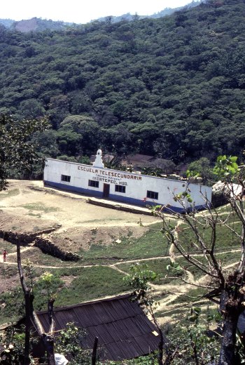
The geographical network of telesecundarias is truly amazing. In the early 1980s, I came across one high in the mountains in a distant corner of the state of Hidalgo, in a remote Huastec village, beyond even Coca Cola’s delivery routes. A visitor was such a surprise that the entire village turned out to inspect me!

Telesecundaria in Ixcatepec, Hidalgo

Telesecundaria in Ixcatepec, Hidalgo (1983) Photo: Tony Burton

It was that experience that made me realize that Mexicans take education very very seriously. The telesecundaria was perched on the hillside overlooking the village. I later discovered this was a fairly typical example, with three classrooms, rustic restrooms in an outhouse, and a small playground. Most telesecundarias also have a science laboratory and a small library.

The students in a telesecundaria do have a teacher, but this teacher teaches every subject, whereas in a regular junior high, each student will have up to twelve different subject specialists. Every telesecundaria classroom has a television set to receive lessons broadcast by the Education Ministry (SEP) in Mexico City.

Professional Programs

In the early days, lessons were very traditional, and the TV programs were little more than continuous shots of a “talking teacher”. Interestingly, almost all those early lessons were broadcast live. Nowadays, the entire process is much slicker and far more professional. The TV programs are 15 minutes long and feature all kinds of material, including animated graphics and video footage. Watching them, you are unlikely to see the “talking teacher” even for an instant! It takes about 20 days to produce each 15-minute module and costs up to 50,000 dollars. Most programs have a useful life of between five and ten years, depending on the timing of significant changes in subject content and teaching methods.

After students have seen the TV broadcast, the classroom teacher then uses the remaining 45 minutes of each hour to explain the lesson in more detail and to monitor students as they complete related tasks from their special telesecundaria textbooks.

Nationwide satellite transmission of programs began in 1994 (EDUSAT), enabling the coverage to spread far beyond those areas previously served by conventional TV stations. Programs are broadcast daily.

On-line samples

With the advent of the Internet, the telesecundarias are now being revamped as one part of SEP’s “On-line educational TV” (“Televisión educativa en línea“) project. That page has links to currently playing segments of material for various levels, including telesecundaria, and for teachers. (This is also a valuable resource for non-native speakers working to improve their Spanish and/or their knowledge of Mexico.)

Telesecundarias have proved to be an extraordinarily effective way of improving access to, and standards of, junior high education across Mexico. While the “costs of delivery” are estimated to be 16% higher in telesecundarias, on a per student basis, than in regular junior high schools, they are significantly cheaper on a per school basis. This means that some of the nation’s 13,000 or so telesecundarias can function cost-effectively even with only 10 or 12 students in each grade level.

The success of telesecundarias

Are telesecundarias successful? It certainly seems so. An estimated 79.4% of telesecundaria students complete grade 9, compared with an equivalent figure of 78.8% for regular junior highs. In addition, one study has shown that telesecundaria students may start Grade 7 significantly behind other students but generally catch up completely in math and reduce the deficit in language.

The program has been adopted by most Central American countries—Costa Rica, El Salvador, Guatemala, Honduras and Panama—and pilot projects are underway in the USA in California, Colorado, Pennsylvania, Oregon and Florida.

So next time you’re traveling in the wilds of Mexico or Central America, play “I spy” and see how many telesecundarias you can find. Bonus marks should be awarded for any that are outside the normal delivery range of Coca-Cola or Sabritas!

The geography of road transport in Mexico

 Excerpts from Geo-Mexico, Updates to Geo-Mexico  Comments Off on The geography of road transport in Mexico
Oct 202011
 

Mexico’s road network is heavily used, accounting for over 95% of all domestic travel.  On a per person basis, Mexicans travel an average of 4500 km (2800 mi) by road each year.

In this post, we try to answer several general questions relating to the geography of road transport in Mexico.

How many cars are there?

On average there are about seven people per car in Mexico, compared to about six in Argentina, ten in Chile and less than two in the USA and Canada. There are far more cars in urban areas with their many businesses, taxis and wealthy residents. In poor rural parts of southern Mexico, private car ownership is quite rare.

Is there an efficient bus system?

Mexico also has an inter-city bus system that is one of the finest in the world. The nation’s fleet of more than 70,000 inter-city buses enables passengers to amass almost half a trillion passenger-km per year.

Where are Mexico’s vehicles made?

Almost all the vehicles on Mexico’s roads were built in Mexico. Mexico’s automobile-manufacturing sector produces about 2.2 million vehicles a year but the majority of production (about 1.8 million vehicles each year) is for export markets. Mexico is the world’s 9th largest vehicle maker and 6th largest vehicle exporter. In recent years, the relaxation of strict import regulations has resulted in more vehicles being imported into Mexico; many of them are luxury models not currently made in Mexico.

The major international vehicle manufacturers with plants in Mexico include Volkswagen, Ford, Nissan, GM, Renault, Toyota and Mercedes-Benz. Mexican companies include Mastretta, which specializes in sports cars, and DINA, a manufacturer of trucks, buses and coaches.

For more information about vehicle manufacturing in Mexico:

Where are Mexico’s vehicles?

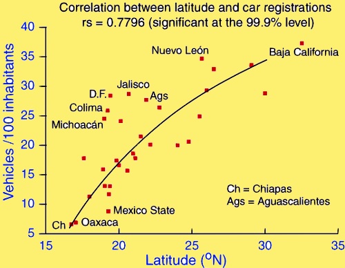
Mexico has about 20 million registered vehicles, about one for every five persons (2005). Which areas have the most and least vehicles? It turns out that the northernmost state, Baja California, has the most with 37 registered vehicles per 100 people. The southernmost states, Chiapas and Oaxaca, have about one sixth as many with 6.6 and 6.9 respectively. In fact there is a very strong statistical relationship between latitude and vehicles (see graph). How can this be?

Scattergraph of latitude and vehicle registrationsWe are not suggesting a direct causal relationship. Many factors are interrelated. First, the states in the north tend to be wealthier; the Spearman rank correlation for GDP/person and latitude is 0.58. Vehicle ownership is closely related to GDP/person (rs = 0.59). Both these correlations are significant at the 99% level.

In addition, northern states are close to the USA, a vehicle-oriented society. However, there are some anomalies to the general pattern. The very wealthy Federal District has 50% more vehicles than would be expected from its latitude alone. States with many migrants, such as Jalisco and Michoacán, also have more vehicles than expected given their latitude. An added complication is that more than a million foreign-plated cars in Mexico (imported temporarily by returning migrants or foreigners) are not included in these figures.

How many road accidents are there in Mexico?

Mexico’s National Council for Accident Prevention estimates that there are 4 million highway accidents each year in Mexico. The latest figures (for 2010) show that there were 24,000 fatalities as a result of these accidents, with 40,000 survivors suffering some lasting incapacity. These figures include some of the 5,000 pedestrians struck by vehicles each year. Traffic accidents are currently the leading cause of death for those aged 5-35 in Mexico, and the second cause of permanent injury for all ages.

Why are there so many accidents?

Driver education plays a major role in road safety. Part of Mexico’s problem is the low budget it allocates each year for road safety—just US$0.40 compared to more than $3.00/person in the USA, more than $7.00/person in Canada and up to $40.00/person in some European countries.

It is no surprise that a high percentage of drivers involved in traffic accidents in Mexico have alcohol in their system. This is one of the reasons why accidents are statistically more frequent in the evenings from Thursday to Saturday. One study reported that as many as 1 in 3 of drivers in Guadalajara was under the influence of alcohol while driving, and 1 in 5 of Mexico City drivers.

Driving without insurance is common in Mexico; according to insurance companies, only 26.5% of Mexico’s 30.9 million vehicles have any insurance.

Related posts:

Mexico receives $280m in international funding to fight urban poverty

 Mexico's geography in the Press  Comments Off on Mexico receives $280m in international funding to fight urban poverty
Oct 172011
 

Today (17 October 2011) is International Day for the Eradication of Poverty. A few weeks ago, the Inter-American Development Bank (IDB) approved a $280 million loan to help fight urban poverty in Mexico through a comprehensive approach that combines efforts targeting both physical needs — increased access to urban services and infrastructure — as well as social needs of people living in marginal areas.

Co-financed with counterpart funds from the Mexican government totaling $280 million, the program will improve urban infrastructure and access to basic services as well as strengthen social integration, benefiting at least 2.2 million homes a year. A special focus will be placed on populations suffering high poverty rates.

The loan will be used to pave roads, and improve water supply, sanitation, electrification and public lighting, waste collection and disposal, among other actions.

On the social side, the program will foster individual and collective skills and promote social inclusion and community participation and organization. This component includes services delivered in Community Development Centers (CDC), such as training workshops targeting different skills, spare time activities promoting civic integration, prevention of risk behaviors in adolescents, and assistance to female victims of violence and support for senior citizens.

This strategy is complemented by a pilot scheme which seeks to expand and improve interventions in selected districts in order to reduce vulnerability to violence with the help of community-based interventions.

The program includes paving or repaving of 17 million square meters of road surface and the laying of 1,000 km of water pipes, 1,350 km of drainage and sewer pipes, and 168 km of electrical wiring. It also provides for the installation of 57,000 street lights, construction and improvement of a total of 300 centers for victims of violence, construction and/or equipping of 840 Community Development Centers.

[This post is the text of a press release from the Inter-American Development Bank. ]

Related posts:

Hurricane Jova smashes into Barra de Navidad and Melaque on Mexico’s Pacific Coast

 Mexico's geography in the Press  Comments Off on Hurricane Jova smashes into Barra de Navidad and Melaque on Mexico’s Pacific Coast
Oct 142011
 

The twin coastal towns of Melaque and Barra de Navidad in the state of Jalisco felt the full force of Hurricane Jova earlier this week. Barra de Navidad has great historical importance as one of the shipbuilding ports where the Spanish built the ships which traversed the Pacific Ocean to the islands of the Philippines.

Full details are only beginning to emerge of the damage done, but the following links show the storm’s path, and some of its immediate impacts:

Fortunately, Hurricane Jova had lost some of its strength by the time it slammed into the coast as a Category 2 hurricane on 12 October. It had previously packed winds of up to 160 km/hr. Even so, it brought torrential rain to coastal areas between the major resorts of Puerto Vallarta and Manzanillo, and heavy rain inland as far as Guadalajara (about 400 km from the coast). In Guadalajara, the flag-raising ceremony to mark the start of the 2011 Pan-American Games was postponed by a day because of continuous rainfall.

In Puerto Vallarta, where several Pan-American Games events are scheduled to be held, including sailing, triathlon, beach volleyball, and open water swimming, authorities secured boats and reinforced the beach volleyball courts with sandbags.

The catastrophe-modelling firm AIR Worldwide says Hurricane Jova will have caused less than $52m of damage as it hit a sparsely populated stretch of Mexico’s Pacific coast downgraded as a Category 2 hurricane.

Many smaller settlements, including Cihuatlán, La Huerta, Villa Purificacion, and Cuautitlán de García Barragán were temporarily cut off as floodwaters made the main coastal highway impassible. Streets in many towns were inundated.

Details of the storm’s track and intensity will (in due course) be available at the National Hurricane Center’s archive for 2011 Eastern Pacific Hurricanes.

Previous hurricane-related posts include:

Hurricanes and other climatological phenomena are analyzed in chapters 4 and 7 of Geo-Mexico: the geography and dynamics of modern Mexico. Buy your copy today, so you have a handy reference guide available whenever you need it.

The maquiladora export landscape

 Books and resources, Teaching ideas  Comments Off on The maquiladora export landscape
Oct 102011
 

InfraNet Lab is “a research collective probing the spatial byproducts of contemporary resource logistics.” Given its emphasis on spatial aspects, it includes many topics of interest to geographers.

InfraNet Lab was included on Planetizen’s 2009 list of the 10 best planning, design, and development websites. Planetizen describes InfraNet Lab as:

“An intense and directed blog focusing on the physical manifestations of controlling resources. It’s a fresh look at the impacts of modern world’s infrastructural needs and the intertwined networks between urbanism, architecture and landscape that result. With archives dating back to April 2008, InfraNet Lab offers a crash course in innovative ideas that reframe the infrastructure conversation around the impacts of human resource dependence and, ultimately, methods for making improvements. An insightful and inciting read for anyone feeling underwhelmed by the status quo of modern-day infrastructure.”

One post on InfraNet Lab of particular interest to us is the guest post by Juan Robles, following an InfraNet Lab seminar at Daniels Faculty of Architecture, Landscape, and Design at the University of Toronto. Robles writes about the landscapes resulting from the growth of maquiladoras in Mexico. He looks at how the necessary infrastructures and networks for maquiladoras to succeed have developed, and how they have transformed the Mexico-US border area. The changes have certainly been profound:

“The ongoing processes of trade and communication that now integrate the 21st century regional economies have created numerous territories of abundance. Among these spaces the maquiladora landscape, in the northern border of Mexico, has seen the greatest change in the last 50 years.”

This is a well illustrated account of the spatial changes associated with maquiladoras, and includes a variety of useful maps and graphics.

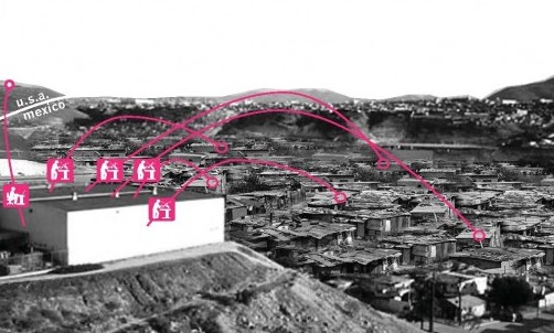
Shanty towns support maquiladoras

Shanty towns support maquiladoras. Credit: Juan Robles/InfraNet Lab.

InfraNet Lab is a valuable resource for AP, A-level and IB. In InfraNet Lab’s words:

The globe’s networked ecologies of food, water, energy, and waste have established new infrastructures and forms of urbanism linking dispersed entities. These agglomerations evolve and shift as resources are uncovered or depleted. While these ecologies exist at the service of our contemporary lifestyles, they have typically remained hidden from view and from the public conscience. Yet as resources of food, fuel and water begin to run scarce, new resources are mined and new networks develop.

InfraNet Lab takes the view that “Long accepted patterns of globalization are being called into question as transportation costs soar and resources run scare, transforming mobility and trading patterns. New local, regional and international networks of goods, movement and trade are beginning to emerge.”

This means that InfraNet Lab offers some very valuable resources for courses such as the IB Geography’s Paper 3 for Higher Level students which looks at the impacts of all kinds of international interactions.

The diffusion of the Africanized honey bee in North America: a bio-geographical case study

 Other  Comments Off on The diffusion of the Africanized honey bee in North America: a bio-geographical case study
Oct 082011
 

Africanized honey bees, sometimes popularly called “killer” bees, resulted from the crossing (hybridization) of European honey bees and African honey bees. They combine the best and the worst of both sets of relatives. Africanized honey bees are slightly smaller than European honey bees, but more aggressive and less inclined to remain in one place. They can swarm and attack even if unprovoked, even though they can sting only once before dying shortly afterward.

Their “killer bee” label is because they have killed 1,000 people in the Americas since their ancestors escaped from a laboratory in Brazil. Africanized bees react ten times faster to disturbances than European bees and can pursue a hapless human victim for 300-400 meters.

The mixing of genes that created Africanized honey bees occurred in the 1950s. In 1956, Dr. Warwick Kerr, a bee researcher in Brazil, hoped to develop a bee that would thrive in Brazil’s tropical climate. He decided to cross European bees with African bees. Unfortunately, in March of the following year, some of his experimental bees escaped into the wild. The Africanized bees soon began to multiply and expand their range. They proved to be very adaptable, and have since spread, at a rate of up to 350 km/year through most of South and Central America, as well as into Mexico and the USA. They arrived in Peru by 1985 and Panama by 1982. Their spread northwards continued, and they crossed from Guatemala into Mexico, near Tapachula, in October 1986.

The map shows the gradual northward spread of Africanized bees in Mexico. Up to 1987, the progression looks fairly regular, but in the following year, Africanized bees’ northward movement was restricted to a zone along Mexico’s Gulf Coast. This remained true even through 1989. By 1990, the “front” of the bees advance once again stretched right across the country.

Q. What factors may have caused the unusual (anomalous) geographic spread of Africanized bees in 1988 and 1989?
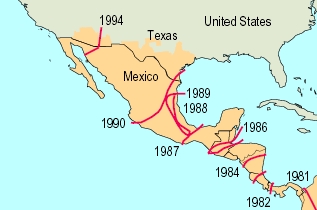
Map of africanized bees spread across Mexico

Africanized bees spread across Mexico (adapted from Kunzmann et al)

Why are Africanized bees more migratory than European bees?

Scientists believe that Africanized bees are uniquely equipped to cope with the unpredictability of suitable food sources in the tropics. They are more opportunistic, changing their foraging habits to suit local conditions, including short-term supplies of pollen, which they will collect and store to ensure their survival. When a new resource presents itself, Africanized bees will swarm rapidly to maximize their use of the new pollen source.

In bio-geographical terms, Africanized bees are an example of an opportunistic or r-species, perfectly equipped to move to new or changing habitats. They reproduce rapidly, and use available resources efficiently. This makes them far less stable than European bees which thrive in a more predictable environment and adapt to changing circumstances far less quickly.

Africanized bees can survive on limited food supplies, will explore and move to new locations frequently and are aggressive in defending their resources. When they come into contact with other less aggressive bees, such as Mexico’s native bees, Africanized bees may out-compete them for pollen and eventually replace them as that area’s dominant bees.

In Mexico, the speed of diffusion of Africanized bees slowed down

When Africanized bees were reported from southern Mexico, US beekeepers began to fret. The US honey industry is worth 150 million dollars a year. Fear spread that Africanized bees might jeopardize the entire industry, mainly because they are prone to migrate, and would be hard to control.

US experts helped finance a joint program in Mexico which aimed to slow down the bees’ progress northwards. The original idea was to stop bees from crossing the narrowest part of Mexico, the Isthmus of Tehuantepec, preventing them from reaching central Mexico. However, by the time funding was approved, some bees had already crossed the Isthmus. The focus of the bee-control plan was changed to trying to slow down their seemingly inexorable progress north. Even if scientists could only delay the bees’ progress, it would give US farmers more time to plan for their eventual arrival.

The plan was relatively simple. Hang sufficient bee traps in trees throughout the region to attract wild swarms while banning Mexican beekeepers from moving any hives from southern Mexico into central or northern Mexico. Thousands of distinctive blue boxes appeared in orchards and forests across a broad belt of Mexico, from the Pacific to the Gulf.

The combined Mexico-US program is credited with having slowed the bees’ entry into the USA down by about two years. Even so, by 1990, Africanized bees were spotted in Texas; they reached Arizona by 1993 and California by 1995. By this time, they were also found throughout Mexico.

In a later post, we will look at honey production in Mexico and see whether or not it was permanently affected by the influx of Africanized bees.

Sources:

(a) “Africanized Bees in North America” by Michael R. Kunzmann et al, in Non-native Species by Hiram W. Li (biology.usgs.gov)

(b) Introduced Species Summary Project: Africanized Honey Bee by Christina Ojar, 2002.

(c) Alejandro Martínez Velasco. Las andanzas de la Abeja Africana Informador (Guadalajara daily), 1 September 1991.

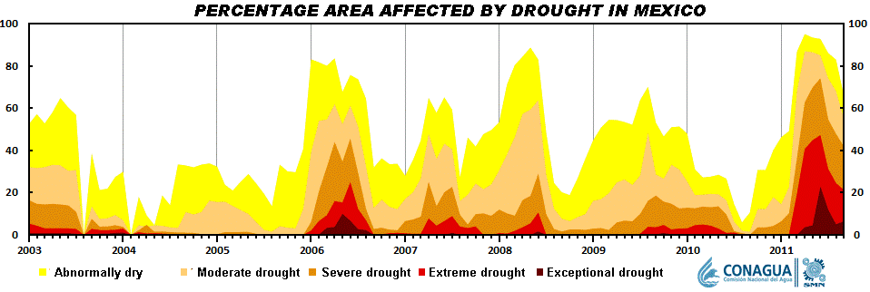
Oct 062011
 

The small town of Tequila, the center of production of Mexico’s national drink, lies in the shadow of an imposing 2700-meter (8860-ft) volcano. Most visitors to the town visit the National Tequila Museum, take a distillery tour, and then sample one or two of the many world-famous brands of tequila made in the area.

The spine of Tequila Volcano

The spine of Tequila Volcano. Drawing by Mark Eager (Western Mexico, A Traveler’s Treasury); all rights reserved.

Tequila Volcano, which overlooks the rolling fields of blue agaves required to make the liquor, is the home of one of Mexico’s most distinctive geomorphosites. From the rim of its crater, the most arresting thing about the view is not the green, tree-covered crater itself but the giant monolith with almost vertical sides rising perpendicularly from the middle of the crater floor.

This well-preserved central spine, known locally as la tetilla (“the nipple”) is quite unusual. It represents the hardened lava which cooled in the central vent of the volcano and which, solid and unyielding, was later pushed upwards by tremendous subterranean pressure.

Few such good examples exist anywhere in the world. The example most often quoted in geography texts is the spine that was pushed up by Mont Pelée on the island of Martinique in the West Indies in October 1902, immediately prior to that volcano’s disastrous eruption which cost 32,000 lives.

How to get there

A cobblestone road begins near the railway station in the town of Tequila and winds up Tequila Volcano towards the short-wave communications tower on its rim. It is about 20 kilometers from the town to the rim. The hike or drive up to the rim affords glorious views over the surrounding countryside. As you gain altitude, so the vegetation changes, becoming luxuriant pine-oak forest well before you reach the rim. Looking across the crater, on a day when clouds slowly drift across and partially obscure the view, is like watching a silent movie of ancient Chinese landscape drawings.

Want to read more?

For a fuller description of a visit to Tequila Volcano and a climb up the volcanic spine, see John and Susy Pint’s Outdoors in Western Mexico (2nd edition 2011).

For a description of Tequila Volcano and the varied villages and sights in its vicinity, see chapters 9 and 10 of my “Western Mexico: A Traveler’s Treasury” (Sombrero Books, 2013), also available in a Kindle edition.

Oct 042011
 

Santa Rosalía in Baja California Sur is one of my favorite places on the Baja California Peninsula. Geography and economics have conspired to change its fortunes more than most towns in the course of history. Originally founded in 1705, the town failed to prosper as its populace faced repeated epidemics, and its farmland was subject to a disastrous flood. The town was largely abandoned by 1828.

A chance find of copper-bearing ore in the middle of the century reversed Santa Rosalía’s fate, and in 1885, a new lease of life was provided when the El Boleo mining company, backed by French capital, was granted a 99-year concession by President Díaz to begin mining for copper in exchange for building all the necessary infrastructure: port, town, mines, railway and foundry. It was judicious timing given that the world market for copper was taking off at precisely that time due to the rising demand for the metal from the fledgling electric companies in Europe and the USA.

Boleo Mine, Santa Rosalía

El Boleo Mine, Santa Rosalía

Within a decade, the mining company had become responsible for more than 80% of Mexico’s exports of copper ingots. The local ore was rich, with up to 25% copper in some samples. Workers flocked in from far afield, including three thousand from China. Working conditions were atrocious, little better than slavery. The health conditions for the miners and foundry workers were appalling;.for example, 1400 deaths were recorded between 1901 and 1903. The company decided on an unusual solution. Rather than move the workers’ homes, it decided to move the smelter chimney. The new chimney was built a kilometer out of town, connected to the smelter by a large, ground-hugging flue. The flue can still be seen today, climbing the hillside immediately behind the Hotel Francés.

By 1900, Santa Rosalía had become a major world copper producer. The smelter relied on supplies of coking coal from Europe, principally from South Wales and Germany. The ships took from 120 to 200 days to reach Santa Rosalía from their home ports. Square-rigged vessels, flying the British or German flag, were constantly arriving in the harbor. When the First World War broke out, several German ships were unable to return to Europe and spent the next few years anchored offshore. The sailors were shocked when they heard that Germany had lost the war; their vessels were eventually distributed among the victors.

The copper deposits were eventually exhausted. The El Boleo mining company closed in 1954, but the state-run Compañía Minera Santa Rosalía continued to mine until 1985, when the smelter was finally shut down, on the eve of the town’s 100th anniversary.

The collapse of the copper mining industry may have caused Santa Rosalía to slip back temporarily into a somnolent slump, but it is now recovering. The mining boom of a hundred and twenty years ago has been replaced by a boom in nature and adventure tourism, which take advantage of the town’s proximity to Conception Bay and the islands in the Sea of Cortés. As we shall see in a future post, because Santa Rosalía has preserved much of its past, it has a massive advantage over its competitors in the region, in that its initial revival fueled by ecotourism can be amplified by cultural or heritage tourism. This beautiful old town and its inhabitants have plenty of reasons to be optimistic as they face up to the challenges of the twenty-first century.

Paddling to an ecotourist future... Photo: Tony Burton

Paddling to an ecotourist future…

And now, the town has another reason for optimism. The massive El Boleo copper cobalt zinc-manganese deposit, which fueled the town’s first boom period, is now being re-developed with new technology. Baja Mining, based in Canada, owns 70% of El Boleo; a consortium of Korean companies owns the remaining 30%. The 1.2-billion-dollar, open-cast mine will add 3,800 jobs to the local economy. During its anticipated 23-year life span, El Boleo is expected to yield more than 2,000 metric tons of cobalt, 25,000 tons of zinc sulfate and 50,000 tons of copper annually.

Sources:

Want to read more?