Disparities in wealth in Mexico: trends include a growing middle class as well as more millionaires

 Mexico's geography in the Press  Comments Off on Disparities in wealth in Mexico: trends include a growing middle class as well as more millionaires
Jun 242013
 

Two recent studies shed an interesting light on the distribution of wealth in Mexico. The first, carried out by the the National Statistics Agency (INEGI) is that agency’s first ever analysis of Mexico’s social classes. The study found that 12.3 million homes and 44 million people (39% of the total population) were “middle class” in 2010, up from 35% in 2000. In urban areas, 47% of the population was middle class, compared to just 26% in rural areas. Middle class homes had at least one computer, spent about 115 dollars [1,470 pesos] a month on eating and drinking outside the home, had at least one resident with a credit card and one with formal employment. In most cases, the head of household had gained a tertiary qualification. The same report found that almost 60% of Mexico’s population matched the criteria for “lower class”, while only 1.7% of the population could be best described as “upper class”.

However, a second study, by consultancy WealthInsight (“Mexico Wealth Book: Trends in Millionaire Wealth“) provides compelling evidence that the number of wealthy and super-wealthy individuals in Mexico has risen sharply. From 2007 to 2012, during the administration of President Felipe Calderón, the number of millionaires in Mexico rose by 32%, whereas the global average for the same period (which included economic recession in the USA and Europe) declined by 0.3%.

WealthInsight found that in 2012 Mexico had 145,000 individuals with a “High Net Worth” (defined as over a million dollars in assets besides their principal residence). Together these high net worth individuals hold a fortune of $736 billion, equivalent to 43% of Mexico ‘s total individual wealth. This number is well above the worldwide average of 29%, indicating that Mexico has a relatively uneven distribution of wealth. What’s more, WealthInsight expects the trend to continue and predicts that by 2017, the number of millionaires in Mexico will grow a further 47% to reach 213,000.

Included in the figure for millionaires are 2,540 multimillionaires (with individual net assets of $30 million or more), 2272 “affluent millionaires”(net assets between $30
million and $100 million) and 252 “centimillionaires” (net assets between $100 million and $1 billion). Mexico also has 16 billionaires, a number expected to rise to 21 by 2017. Grouped together, these ultra high net worth individuals are worth $364 billion in total combined wealth. By 2017 the total wealth of multimillionaires is projected to increase by 44% to reach $525 billion. The report predicts that the total wealth of Mexican billionaires will grow by 26% to reach $241 billion by the end of 2017.

The Mexican city with most multimillionaires is Mexico City; 43% of them make their home there.

Related articles:

Mexico the fourth most obese country in the world

 Mexico's geography in the Press  Comments Off on Mexico the fourth most obese country in the world
Jun 062013
 

Earlier this week, the headline “Ocupa México primer lugar mundial en obesidad; supera a EU” (Mexico in first place for obesity; more obese than the USA)  grabbed my attention. The headline appeared in the Mexican magazine Proceso, normally a stickler for getting its facts straight.

Last time we checked (October 2012)–Obesity in Mexico compared to other countries: bigger is not better–Mexico was in fourth place in the obesity league table, behind Saudi Arabia, Egypt and the USA. [Note that our ranking excludes several very small countries with higher rates of obesity, such as Nauru (71.1%), Cook Islands (64.1%), Marshall Islands (46.5%), Kiribati (45.8%) and St.Kitts-Nevis (40.9%).]

The Proceso article was based on the latest United Nations Food and Agriculture Organization (FAO) report entitled “The State of Food and Agriculture: Food Systems for a Better Nutrition

On reading the report, it turned out that Proceso had made an unaccustomed error. Mexico is not the most obese country in the world, but remains in fourth place, behind Saudi Arabia, Egypt and South Africa. Mexico has overtaken the USA but has itself been overtaken by South Africa. Normally, any time Mexico beats the USA, whatever the sport or event, it calls for a good old-fashioned celebration with some shots of tequila, but on this occasion, it raises some serious concerns about Mexico’s nutrition and health care strategies.

Obesity in adults is defined by the World Health Organization (WHO) as a Body Mass Index (BMI) greater than or equal to 30, where BMI is defined as a person’s weight in kilograms divided by the square of his height in meters (kg/m2). Mexico’s rate (for adults), as quoted in the FAO report, had risen to 32.8% of the adult population, almost one in three. By way of comparison, the equivalent figures were 35.2% for Saudi Arabia and 34.6% for Egypt, while the USA rate fell slightly to 31.8%.

The FAO estimates that 12.5% of the world’s population (868 million people) are undernourished in terms of energy intake, yet these figures represent only a fraction of the global burden of malnutrition (over- and under-nutrition). An estimated 26% of the world’s children (under 5 years of age) are stunted, 2 billion people suffer from one or more micronutrient deficiencies and 1.4 billion people are overweight, of whom 500 million are obese.

Most countries are burdened by multiple types of malnutrition, which may coexist within the same country, household or individual.

The social cost of malnutrition, measured by the “disability-adjusted life years” (DALY) lost to child and maternal malnutrition and to overweight and obesity, is very high. Beyond the social cost, the cost to the global economy caused by malnutrition, as a result of lost productivity and direct health care costs, could account for as much as 5% of global gross domestic product (GDP), equivalent to US$3.5 trillion per year or US$500 per person.

The FAO stresses that, “The way we grow, raise, process, transport and distribute food influences what we eat,” and adds that improved food systems can make food more affordable, diverse and nutritious.

The report makes a number of recommendations, including using appropriate agricultural policies, investment and research to increase productivity; cutting food losses and waste, which currently amount to one third of the food produced for human consumption every year; and helping consumers make good dietary choices for better nutrition through education, information and other actions.

Among other recommendations is to make food systems more responsive to the needs of mothers and young children. FAO notes that malnutrition during the critical ‘first 1,000 days’ from conception can cause lasting damage to women’s health and life-long physical and cognitive impairment in children.

The agency cites several projects that have proved successful in raising nutrition levels such as the promotion of home gardens in West Africa; encouragement of mixed vegetable and animal farming systems together with income-generating activities in some Asian countries; and public-private partnerships to enrich products like yoghurt or cooking oil with nutrients.

Other figures for Mexico from the report:

  • 29.4% of children under five have anemia
  • 26.8% of children under five suffer from vitamin A deficiency
  •  8.5% of children under five have an iodine deficiency

Note: This post includes some paragraphs from the related FAO press release. Click here for the full text of the report (pdf file).

Related posts:

Five Mexican beaches gain international Blue Flag certification

 Mexico's geography in the Press  Comments Off on Five Mexican beaches gain international Blue Flag certification
Jun 032013
 

For the first time ever, five Mexican beaches have been awarded Blue Flag certification. The Blue Flag system is a voluntary, international eco-label program run by the non-government, non-profit organization the Foundation for Environmental Education that recognizes beaches where water quality is excellent, where information and environmental education is readily available, and which are well managed, with high standards of safety and services. The announcement was made in Copenhagen, Denmark, where Blue Flag certification was given to 3100 beaches and 625 marinas worldwide.

Blue flag beaches in Mexico 2013

Mexico’s five Blue Flag beaches (see map) are:

  • Chahué, Santa María de Huatulco, Oaxaca
  • Chileno, in Los Cabos, Baja California Sur
  • Delfines, in Cancún, Quintana Roo
  • El Palmar, in Zihuatanejo, Guerrero
  • Nuevo Vallarta Norte, on Banderas Bay in Nayarit

What does the Blue Flag system take into account?

The Blue Flag beach criteria are grouped into four main categories:

1. Environmental Education and Information

The beach must host at least 5 environmental education activities and display information about:

  • coastal zone ecosystems and natural, sensitive areas in the coastal zone
  • bathing water quality
  • the Blue Flag system
  • the code of conduct for the beach area

2. Water Quality

  • Water quality must be “excellent” in line with international standards
  • The beach must not receive any industrial or sewage-related discharges
  • Any nearby coral reefs must be monitored to ensure they remain healthy
  • Algae, seaweed, etc., should be left on the beach unless it adversely affects beach quality

3. Environmental Management

  • A beach management committee must conduct regular environmental audits
  • The beach must comply with coastal zone planning and environmental legislation
  • The beach must be clean, with sufficient waste disposal and recycling bins
  • There must be adequate and clean sanitary facilities
  • Regulations must prevent unauthorized camping, driving and dumping
  • Regulations concerning beach use by domestic animals must be enforced
  • Sustainable means of transportation must be promoted in the beach area

4. Safety and services

The beach must have:

  • first aid equipment and an adequate number of lifeguards and/or lifesaving equipment
  • a system to manage beach use and prevent conflicts and accidents
  • emergency plans to cover any unexpected pollution event
  • safe access to the beach and regular safety patrols
  • a supply of potable drinking water
  • access and toilets for persons with disabilities
  • a map showing the location of all facilities

Related posts:

May 272013
 

Kudos to the Earth Island Institute for responding to the many criticisms we and others made of a blog article (“Water Pollution Plagues Mexico’s Scenic Pacific Coast”) by pulling it from their website. The following post has been edited to reflect that fact.

Water quality is a serious concern in many parts of Mexico and Geo-Mexico regularly includes short articles about the main issues as well as case studies related to water pollution (see “Related posts” below).

Ron Granich, a regular Geo-Mexico reader who lives in Pátzcuaro (Michoacán) and recognizes our keen interest in Mexico’s water quality kindly drew our attention to a recent article published on the website of the Earth Island Journal. Sadly, the blog article left much to be desired. The article was subtitled, “Tourists largely unaware that industrial pollution from rivers upstream is making them sick”, and attempted to argue that the pollution of Mexico’s Santiago River is a direct cause of the poor water quality of beach towns such as Sayulita.

The slight problem with this thesis is that the Santiago River flows nowhere near Sayulita and has no connection to the miniscule Sayulita River, far to its south (see map). There is no question that the Santiago is polluted. It collects serious pollutants from the major industrial area of El Salto (a short distance southeast of Guadalajara) and from Guadalajara, and from many smaller settlements along the way. More contaminants are added near its mouth, where the swampy delta has been transformed into productive fields, including tobacco plantations.

Main rivers of Western Mexico.

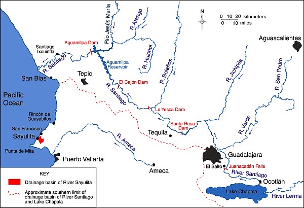
Map of the main rivers of Western Mexico. Credit: Tony Burton / Geo-Mexico; all rights reserved.

Pollution of the River Santiago is particularly evident at the Juanacatlán Falls near El Salto:

After the Juanacatlán Falls, the Santiago flows in a deep, steep-sided canyon for most of its course (which explains why no fewer than three major dams for hydro-electric power have been built along this stretch, including the one at La Yesca) before meandering across its delta to flow into the Pacific Ocean a short distance north of San Blas.

The Santiago River has no conceivable influence on the pollution levels in the rivers near Sayulita and San Francisco or indeed on beaches in their vicinity. This is not to say that those beaches are clean. The beaches of the Nayarit Riviera may indeed have high levels of Enterococcus spp, as we reported recently when looking at the murky world of water statistics in Mexico.

Note on clean water standards in Mexico and the USA:

It is sometimes argued that Mexico and the USA have different standards for what represents “clean water”. For marine (beach) environments, the U.S. limit is 35 Enterococci per 100 ml. of water, and is based on calculating a geometric mean of counts performed over a five week period. This method greatly reduces the impact of peak Enterococci counts. However, the Mexican limit of 100 Enterococci/100 ml. is based on a single sample maximum value. As explained in this US EPA technical document, Water Quality Standards for Coastal Recreation Waters: Using Single Sample Maximum Values in State Water Quality Standards, the two limits are approximately equivalent in terms of water quality. In other words, a geometric mean of 35 Enterococci/100 ml. means that the water is about as clean as a single maximum value of 100 Enterococci/100 ml.

Water quality IS a major concern in much of Mexico, and we applaud the Earth Island Institute for seeking to draw attention to the issues involved, and for their recent action in removing the original article, which helps to ensure that discussions of these issues are based on facts and not on misconceptions.

As always, we welcome discussion about this (and all our posts) via the comments feature. If the comments feature is not visible, simply click the title of the relevant post, and scroll down.

Related posts:

Hurricane names and forecast for 2013

 Mexico's geography in the Press  Comments Off on Hurricane names and forecast for 2013
May 112013
 

The 2013 hurricane season in Mexico is underway. The “official” hurricane season is from 15 May to 30 November each year for Pacific coast storms, and from 1 June to 30 November for Atlantic storms, though most hurricane activity is concentrated in the months from July to September. Hurricanes are also known as typhoons or tropical cyclones.

The table shows the World Meteorological Organization’s official list of 2012 hurricane names. Note that male and female names alternate. Names are often reused in future years, with the exception of the names of any particularly violent storms, which are officially “retired” from the list for a long time.

2013 Hurricane Names for the Atlantic, Gulf of Mexico and Caribbean
AndreaGabrielleLorenzoRebekah
BarryHumbertoMelissaSebastien
ChantalIngridNestorTanya
DorianJerryOlgaVan
ErinKarenPabloWendy
Ferdinand

2013 Hurricane Names for the Eastern Pacific
AlvinGilManuelTico
BarbaraHenrietteNardaVelma
CosmeIvoOctaveWallis
DalilaJuliettePriscillaXina
ErickKikoRaymondYork
FlossieLorenaSoniaZelda

In their early season forecast for this year, Philip Klotzbach and William Gray, researchers at Colorado State University,  expect hurricane activity in the Atlantic to be significantly higher than the 1981-2010 average. They write that, “The tropical Atlantic has anomalously warmed over the past several months, and it appears that the chances of an El Niño event this summer and fall are unlikely”. (A strong el Niño is likely to minimize Atlantic hurricane activity). They predict that in the 2013 season 18 named storms will form in the Atlantic: 9 tropical storms, 5 moderate hurricanes (1 or 2 on the Saffir-Simpson scale), and 4 severe hurricanes (3, 4 or 5 on the Saffir-Simpson scale). These forecasts will be updated on 3 June and 2 August.

saffir-simpson-scale

For the Pacific coast, Mexico’s National Meteorological Service (Servicio Metrológico Nacional, SMN) is expecting 14 named storms: 6 tropical storms, 4 moderate hurricanes (1 or 2 on the Saffir-Simpson scale), and 4 severe hurricanes (3, 4 or 5 on the Saffir-Simpson scale). The SNM publishes regular updates on hurricane activity (in Spanish) on its webpage and via its Twitter account: @huracanconagua.

How accurate was the forecast in 2012?

The late season (3 August) prediction for 2012 (last year) was for 14 named storms in the Atlantic: 8 tropical storms, 4 moderate hurricanes and 2 severe hurricanes. In reality, the 2012 Atlantic season had 19 named storms: 9 tropical storms, 8 moderate hurricanes and 2 severe hurricanes.

Related posts:

Mexico seen as the “Flavor of the Month” among Latin American Economies

 Mexico's geography in the Press  Comments Off on Mexico seen as the “Flavor of the Month” among Latin American Economies
Apr 062013
 

In a presentation entitled “Mexico’s Outlook” in Ajijic, Jalisco, Mexico, on 20 March 2013, noted Mexican political economist Leo Zuckermann explained how many economists see Mexico as the “flavor of the month” among Latin American economies.  Brazil previously was the star of Latin America as evidenced by the 14-20 November 2009 cover of  The Economist. However, Brazil’s performance slowed considerably in 2012; its GDP grew by only 1.0% and the dollar value of its stock market actually declined by 0.5% in 2012. (The Economist, 19 January 2013, p 93)

Economist covers

Mexico is the new star according to The Economist 14-page Special Report on Mexico in its 24-30 November 2012 edition. Mexico’s GDP grew by 4.0% in 2012, faster than the US, Canada and all European economies, though it did trail China (7.7%), India (5.4%), Indonesia (6.3%) and Thailand (5.8%). In dollar terms its stock market shot up an impressive 33.6% in 2012, tied with Germany and faster than all other sizable countries, except Turkey (75.8%), Thailand (45.9%) and Egypt (43.9%). (The Economist, 19 January 2013, pp 92, 93).

Mexico is expected to grow by 3.5% in 2013. However, it should be noted that after appearing on The Economist cover in November 2009, Brazil’s GDP declined steadily from over 8% to only 1%. We hope that Mexico can avoid this Economist cover jinx.

Mexico’s recent growth and positive outlook is largely dependent on continued expansion of exports, particularly the sale of automobiles and electronics to the USA. In 2013, Mexico is expected to surpass Japan as the leading exporter of light vehicles into the USA.

Though Mexican industrial export numbers are impressive, many of the components of these exports are initially imported. For example, the foreign content of Mexico’s electronic exports is 61%, compared to about 40% for China, 45% for Korea and only 11% for the USA.

Much of Mexico’s export capacity results from foreign direct investment in Mexico. However, such investment declined from nearly $30 billion a year in 2007 and 2008 to only $12.7 billion in 2012 (The Economist, 19 January 2013, pp 92, 93). This could limit export growth in future years. Furthermore Mexican direct investment abroad in 2012 was $25.5 billion almost twice the amount foreigners invested in Mexico. Prior to 2012 foreigners invested far more in Mexico than vice versa. This trend suggests that many Mexican investors see better opportunities abroad than in Mexico. Such investments are one reason for the rapid foreign expansion of some major Mexican multinational corporations such as Cemex, América Móvil, FEMSA and Bimbo. Another factor suggested by these numbers is that both foreign and Mexican investors do not see many attractive opportunities for domestic industries selling to the Mexican market. If Mexico is indeed now the “flavor of the month,” it remains to be seen if Mexico can retain its current popularity.

Related posts:

Mexico has the world’s highest level of energy security among large economies

 Mexico's geography in the Press, Updates to Geo-Mexico  Comments Off on Mexico has the world’s highest level of energy security among large economies
Apr 042013
 

According to a recently published U.S. Chamber of Commerce study of the largest energy-consuming nations, Mexico is the most energy secure country of the 25 countries in the large energy user group with a score 14% below the OECD average (see graph).

energy security graph (US Congress)

The study compiled an “International Index of Energy Security Risk”, taking into account 28 metrics including fossil-fuel imports, power generation and carbon-dioxide emissions, using data from sources such as the U.S. Energy Information Administration and the Paris-based International Energy Administration.

Other countries with high levels of energy security included the U.K., Norway, New Zealand, Denmark, Australia and the U.S. (Which tanked 7th overall. Energy security was lowest in the Ukraine, followed by Thailand, South Korea, the Netherlands, Brazil, Italy, Turkey and Japan.

Mexico’s energy security has ranked as first or second among the large energy user group of countries every year since 1980. The metrics where Mexico has a significant comparative advantage over other OECD members include:

  • low amount it spends on fuel imports per dollar of GDP generated
  • low energy expenditures per dollar of GDP and per capita are also lower
  • low costs to produce electricity.
  • low amount of energy each person uses, both overall and in the transport sector
  • low amount of carbon dioxide each person emits

As the graph shows, however, Mexico’s energy security is edging closer to that of OECD countries, meaning that Mexico’s comparative advantage in energy security is slowly shrinking.

Mexico is the world’s seventh largest oil producer, and also a major oil exporter. While production levels had been declining, they have begun to rise again in recent months. Mexico also has large reserves of natural gas, but these have not been developed quickly enough to prevent imports of natural gas from rising sharply in recent years as demand for natural gas outstrips domestic supply.

Related posts:

Environmental news briefs relating to Mexico

 Mexico's geography in the Press  Comments Off on Environmental news briefs relating to Mexico
Apr 022013
 

This post describes several newsworthy developments relating to Mexico’s natural environment.

Financing to fight deforestation

The Inter-American Development Bank is giving Mexico $15 million in financial and technical assistance to support climate change mitigation efforts. The program will help communities and ejidos finance low carbon projects in forest landscapes in five states, all of which have high levels of net forest loss: Oaxaca, Yucatán, Quintana Roo, Jalisco and Campeche.

The program includes a $10 million loan for financing projects that must reconcile economic profit for the communities and generate environmental benefits through reducing the pressure on forests and promoting enhancement of carbon stocks. In addition, a $5 million grant will provide financial and technical assistance to support the viability of individual projects, by strengthening technical, financial and management skills.

The IDB says that the program is a pilot project that will allow lessons to be learned for its replication in other key geographic areas in Mexico. It should demonstrate a viable business model that promotes the reduction of deforestation and degradation while increasing economic returns. [based on an IDB press release]

Mexican company converts avocado seeds into biodegradable plastic

A Mexican company called Biofase has developed a way to turn avocado pits into 100% biodegradable plastic resins. Avocado pits are normally discarded as waste. Biofase will collect some of the estimated 30,000 metric tons of avocado pits discarded each month for processing. The company has patented the technology and is looking for additional raw material containing some of the same chemicals as avocados.

Huichol Indians oppose peyote conservation measure

A presidential decree signed last November prohibits the harvesting of the hallucinogenic peyote cactus from two protected areas in the state of San Luis Potosí. The decree has met fierce opposition from the indigenous Huichol (Wixarika) people, for whom the peyote is a sacred plant. The Huichol undertake a lengthy pilgrimage each year to gather peyote for subsequent use in their ceremonies.

The restriction on peyote harvesting is the latest in a long line of problems faced by the Huichol including the incursion by a large number of mining companies onto traditional territory. The Regional Council for the Defense of Wirikuta has demanded that the government guarantee the Huichol’s right to pick peyote, and called for the cancellation of 79 mining concessions (most of them to Canadian companies) that impinge on their sacred land. Critics claim that mining is having a devastating impact on the local environment, especially because the companies involved are using large quantities of highly toxic cyanide.

Expand the port or protect the coral reef?

In Avalan destruir arrecifes para ampliar puerto de Veracruz published in Mexico City daily La Jornada, Luz María Rivera describes how one of the final acts of the previous administration was to redraw the boundaries of the protected area of coral reef off the coast of Veracruz state. The new boundaries have reduced the protected offshore area near the cities of Veracruz, Boca del Río and Alvarado by about 1200 hectares (3000 acres). The redrawing of the protected area is to enable the expansion of the port of Veracruz, one of the country’s largest, and almost double its capacity. Government officials claimed that the area affected was already “damaged” and that the reef system was 98% or 99% “dead”.

Government-NGO accord to protect Mexican whale sanctuary

The Mexican government has signed an accord with the NGO Pronatura Noroeste to improve the protection of Laguna San Ignacio, the Pacific coastal lagoon which is a major breeding ground for gray whales. The lagoon has 400 kilometers (250 miles) of coastline, bounded by wetlands and mangroves, and is part of the El Vizcaino Biosphere Reserve in the northern part of the state of Baja California Sur. The accord calls for joint development of plans for protection, monitoring and tracking the whales and other species that inhabit the lagoon, as well as  establishing protocols for resolving any eventual environmental contingencies.

Related posts:


Popocatapetl Volcano and Colima Volcano continue to erupt

 Mexico's geography in the Press, Updates to Geo-Mexico  Comments Off on Popocatapetl Volcano and Colima Volcano continue to erupt
Mar 302013
 

In our series of brief updates on topics featured in previous Geo-Mexico posts, we look this week at the continuing eruption of two major volcanoes: Popocatapetl Volcano (between Mexico City and Puebla) and Colima Volcano (on the Jalisco-Colima state border in western Mexico).

Popocatepetl, 30 July 2012

Popocatepetl, 30 July 2012

Since our previous post, about a year ago, entitled Alert level rises as Popocatepetl volcano starts to erupt, Popocatapetl Volcano (photo) has continued to be active, with up to 250 activity events a day. The alert level has been reduced slightly to Yellow Phase 2, the fourth highest level. This level indicates intermediate scale explosive activity and possible expulsion of lava, explosions of increasing intensity and wind-blown ash falling on nearby villages. The volcano is monitored daily, and updates from CENAPRED  (in Spanish and English) are issued every 24 hours.

The report issued on 27 March is typical of recent months. In the previous 24 hours, there were 83 low intensity events with emissions of gas, water vapor and ash. The two largest events sent material rising 1000 meters and 600 meters into the atmosphere respectively, before the wind blew the material north eastwards (away from Mexico City).

Colima Volcano

In January 2013, we reported how Colima Volcano erupts, destroying lava dome first created in 2007. The volcano has continued to erupt in the ten weeks since then. The experts monitoring the volcano have reported up to 200 eruptive events a day, with numerous minor emissions of lava. Local villagers have been asked to remain on alert, though the experts are not yet calling for any villages to be evacuated.

The image below (source: Nasa Earth Observatory) shows Colima Volcano in 2010, part way into its current eruptive phase which is expected to last several years. The image shows the evidence at that time of four different types of volcanic activity:

  • lava dome growth
  • explosive eruptions
  • flank collapse
  • lava flows.

(Note that the 2013 eruptions have significantly altered the top of the volcano since this image was taken).

Nasa Earth Observatory)

Colima Volcano in 2010 (Nasa Earth Observatory)

Related posts:

Mexico’s tourist industry plans to increase tourist expenditures

 Mexico's geography in the Press  Comments Off on Mexico’s tourist industry plans to increase tourist expenditures
Mar 022013
 

The tourism and travel industry in Mexico accounts for about 13% of GDP. Speaking last month at the XI National Tourism Forum in the resort city of Cancún, Mexico’s Tourism Secretary Claudia Ruiz Massieu outlined the National Tourism Strategy 2013-2018. The new plan places more emphasis on increasing the average expenditures of tourists than on boosting total visitor numbers. It aims to revive the appeal and occupancy rates of existing destinations, rather than adding new resorts, and to diversify tourist attractions through programs such as Magic Towns and routes catering to specific interests such as Mexican cuisine. Other objectives include improved airline connectivity and simplified border crossing procedures.

Tourist spending in Mexico rose to 12.72 billion dollars in 2012, 7.17% more than in 2011, but visitor numbers fell by about 1%. The World Tourism Organization ranked Mexico as the 13th most visited country in the world in 2012, a significant drop from the 10th place it had occupied for several years.

cancun-40-yearsCancún has added a major tourist attraction with the opening last year of the Mayan Museum of Cancún in the city’s Hotel Zone. The museum replaces the former Mayan Museum closed in 2005 following damage from Hurricane Wilma. Built by the National Institute of Anthropology and History (INAH) at a cost of $15 million, the museum is that organization’s largest single project for some 30 years. It houses 3500 archaeological pieces, 350 of which are on permanent display, and is expected to attract up to a million visitors a year. Adjacent to the museum is the archaeological site of San Miguelito, the most important Mayan settlement on Cancún Island, also now open to the public.

Related posts:

The geography of Mexico’s drug trade: new cartels involved in turf wars

 Mexico's geography in the Press, Updates to Geo-Mexico  Comments Off on The geography of Mexico’s drug trade: new cartels involved in turf wars
Feb 202013
 

As we suggested a year ago – Mexico’s drug cartels and their shifting areas of operation, a 2012 update  – it is increasingly difficult to track the areas of operation of the major drug trafficking groups in Mexico. The U.S. Department of the Treasury’s Office of Foreign Assets Control recently added a new narcotrafficking group in Mexico, the Meza Flores family, to its list of Foreign Narcotics Kingpins. (This designation prohibits people in the USA from engaging in transactions with the named individuals or their organization, and freezes any assets the individuals or organization may have under U.S. jurisdiction).

According to the Treasury Department’s statement, the Meza Flores family began operations in about 2000 and is responsible for the distribution of considerable quantities of methamphetamines, heroin, cocaine and marijuana in the USA. It is headed by Fausto Isidro Meza Flores (aka “Chapito Isidro”) and is based in the town of Guasave, in the state of Sinaloa. (Meza Flores was previously in the Juárez cartel before becoming a high ranking member of the now defunct Beltran Leyva cartel).

The Meza Flores group is a direct rival of the long-established and very powerful Sinaloa cartel. The Sinaloa cartel is headed by Joaquín “El Chapo” Guzmán Loera, who has been on the run since escaping from the maximum security jail in Almoloya de Juárez, near Toluca, in 2001. According to Forbes Magazine, Guzman Loera is currently Mexico’s 10th richest individual, with assets of around one billion dollars.

Mexico’s “War on Drugs” in recent years has led to a fragmentation of the major cartels. Some experts claim that as many as 80 distinct groups are now involved in drug production and trafficking. Many of these groups are small and highly localized, but this fragmentation has increased the incidence of turf wars between rival groups. These turf wars have caused extreme levels of violence in some parts of the country. Once one side is firmly in control, the violence drops.

The current federal administration has said that some 70,000 people died in Mexico between 2006 and 2012 as a result of the activities of organized crime. Recent press reports such as Jalisco: La invasión de Los Templarios claim that one on-going boundary war is along the state boundary between Michoacán and Jalisco. This conflict is between the Michoacán-based Knights Templar (Los Caballeros Templarios, LCT) and the Jalisco-based New Generation cartel (CJNG).

The LCT is comprised largely of former members of  La Familia Michoacana (LFM), a group which is now almost defunct. Other members of LFM joined the Zetas, the Sinaloa cartel’s arch enemy. The CJNG started out as enforcers for the Sinaloa Cartel.

Violence linked to this particular turf war has occurred in numerous municipalities including Jilotlán de los Dolores, Pihuamo, Mazamitla, San José de Gracia, La Barca, Atotonilco, Ayotlán, Tizapán el Alto, Tuxcueca, Jocotepec and Chapala (all in Jalisco), as well as Briseñas, Yurécuaro, Sahuayo, Marcos Castellanos, La Piedad, Zamora, Cotija de La Paz, Tepalcatepec, Los Reyes, Peribán and Apatzingán (all in Michaocán).

This is not the only turf war currently underway in Mexico. For example, further north, another recent hot spot has erupted along the Durango-Coahuila border, especially in the La Laguna area centered on the city of Torreón.

Related posts:

Ecological footprints, marine conservation and Cancun’s underwater sculpture park

 Mexico's geography in the Press  Comments Off on Ecological footprints, marine conservation and Cancun’s underwater sculpture park
Feb 112013
 

The Global Ocean Commission, a new, high-level international effort to try to stave off eco-disaster in the world’s oceans, is being launched tomorrow in London, U.K.. Headed by former UK foreign secretary, David Miliband, former South African finance minister Trevor Manuel, and José María Figueres, a former president of Costa Rica, the Commission will promote international efforts to ensure the effective governance of international waters, and agreements governing such activities as deep sea fishing, pirate fishing, sea-floor mining and geo-engineering, all considered to be potential threats to the long-term viability of ocean ecosystems.

Miliband is quoted as saying that “We are living as if there are three or four planets instead of one, and you can’t get away with that.” Actually, the ecological footprint of the USA, as one example, is much closer to ten “global hectares per person” than three or four. (Each global hectare encompasses the average annual productivity of all biologically productive land and ocean areas in the world). The world’s biocapacity—the amount of resources its ecosystems can supply each year—is only equivalent to about 2 global hectares per person, a value that is declining each year as population increases (see Mexico’s ecological footprint compared to that of other countries).

2002 Postage Stamp: reef conservation

2002 Postage Stamp: reef conservation

Mexico is one of the six most biodiverse countries in the world. While it has taken many steps to protect its marine resources, by enacting legistlaiton establishing fishing restrictions and protected areas, much remains to be done. Mexico’s coral reefs are particularly vulnerable. For example, the Cancún Marine Park is one of the most visited stretches of water in the world with over 750,000 visitors each year, placing immense pressure on its resources. We described one unusual conservation effort related to this area in “Artificial reef near Cancún doubles as an underwater art gallery” [Mar 2012] which looked at the work of Artist Jason deCaires Taylor, who created an underwater sculpture park, the Underwater Art Museum (Museo Subaquatico de Arte, MUSA), near Cancún.

The museum, begun in 2009, currently consists of more than 450 permanent life-size sculptures set in the waters surrounding Cancún, Isla Mujeres and Punta Nizuc. Taylor is adding sixty additional underwater sculptures to the park, many of them modeled after local residents. This underwater museum is both attractive and functional, providing new habitat for coral and other marine life, as well as diverting snorkelers and divers away from fragile coral reefs, allowing them more chance to recover from the impacts of overuse.

Cyclists retaking the streets of Guadalajara

 Books and resources, Mexico's geography in the Press  Comments Off on Cyclists retaking the streets of Guadalajara
Feb 022013
 

The popularity of cycling is growing rapidly in several Mexico cities. Mexico City has created bike lanes, an Ecobici system for short-distance hires, and holds numerous cycling events and rallies, designed to appeal to the whole family, not just to commuters.

Guadalajara, Mexico’s second largest city, now has a higher density of car use than Mexico City, according to “Over the Wheel—Mexico“, a documentary made recently for Aljazeera TV by Juan Pablo Rojas. Rojas, a native of the city, is a long-time film maker. He focuses his documentaries “on those sectors of society that are promoting new paradigms of life based on social equality, awareness, development, conservation and sustainability.”

Via RecreActiva in Guadalajara. Photo by supernova.gdl.mx

Via RecreActiva in Guadalajara. Photo by supernova.gdl.mx

Over the Wheel—Mexico” takes a look at the growing cycling culture in Guadalajara, a city of some four million people and almost two million motor vehicles. It looks at the dedicated work of several committed groups of activists, such as GDL en bici [Guadalajara by bike],  who are striving to persuade car owners to change their habits and make the streets safer for alternative, cleaner corms of transport such as bicycles. Among other things, the activists have begun a “bicicleta blanca” movement in which white-painted bicycles are mounted as a memorial wherever a cyclist is killed in a traffic accident.

Can cyclists reclaim the streets of Guadalajara from cars? This 25-minute documentary, which has Spanish language commentary and English subtitles, looks at how a quiet revolution in sustainable urban transport is slowly unfolding in Guadalajara.

Further evidence of the growing popularity of cycling in Guadalajara is provided by the success of the weekly “Via RecreActiva” (see image). Every Sunday, city officials close over 65 km (40 mi) of city streets to motorized vehicles for six hours from 8 a.m. to 2 p.m. Up to 200,000 people take over the streets. Most are on bicycles, but others are walking, jogging, rollerblading or skateboarding.

Want to read more?

Related posts:

Mexico City wins 2013 Sustainable Transport Award

 Mexico's geography in the Press  Comments Off on Mexico City wins 2013 Sustainable Transport Award
Jan 192013
 

The Institute for Transportation and Development Policy (ITDP), together with an international committee of transportation and development experts, has awarded Mexico City the 2013 Sustainable Transport Award.

The Institute for Transportation and Development Policy works with cities worldwide to bring about sustainable transport solutions that cut greenhouse gas emissions, reduce poverty, increase urban mobility and improve the quality of urban life.

The 2013 Sustainable Transport Award recognizes Mexico City’s Bus Rapid Transit (BRT) system, cycling and walking infrastructure, parking program, and revitalization of public space. Established in 2005, the Sustainable Transport Award recognizes leadership and visionary achievements in sustainable transportation and urban livability, and is presented to a city each January for achievements in the preceding year.

Mexico City Metrobus

The Sustainable Transport Award was presented to Mexico City on January 15, 2013 at an awards ceremony during the annual meeting of the Transportation Research Board, one of six major divisions of the U.S. National Research Council. ITDP board president and former Mayor of Bogotá Enrique Peñalosa presented Mexico’s Minister of Transport, Rufino León, and Minister of Environment, Tanya Muller with the award. The former Mayor of Mexico City, Marcelo Ebrard, who oversaw much of Mexico City’s sustainable transport projects, made closing remarks at the ceremony. Janette Sadik-Khan, Commissioner of the New York City Department of Transportation, delivered the keynote address.

Mexico City has implemented many projects in 2012 that have improved livability, mobility, and quality of life for its citizens, making the Mexican Capital a best practice for Latin America.

  • The city expanded its Bus Rapid Transit system, Metrobús, with Line 4, running along a corridor from the historic center of the city to the airport.
  • The city piloted a comprehensive on-street metered parking program, EcoParq.
  • The city opened line 12 of its Metro system (Sistema de Transporte Colectivo Metro).
  • The city expanded its successful public bike system Ecobici, and added new bike routes (ciclovías).
  • The city revitalized public spaces including the Alameda Central and Plaza Tlaxcoaque.

The finalists and winner were chosen by a Committee that includes the most respected experts and organizations working internationally on sustainable transportation. The Committee includes the Institute for Transportation and Development Policy, The World Resources Institute Center for Sustainable Transport,  GIZ (Deutsche Gesellschaft für Internationale Zusammenarbeit), Clean Air Asia, Clean Air Institute, United Nations Centre for Regional Development (UNCRD), Transport Research Laboratory, EcoMobility, Local Governments for Sustainability (ICLEI) and the Transport Research Board’s Transportation in the Developing Countries Committee.

“Mexico City was like a patient sick with heart disease, its streets were some of the most congested in the world”, says Walter Hook, CEO of ITDP, “In the last year, Mexico City extended its great Metrobus BRT system straight through the narrow congested streets of its spectacular historical core, rebuilt public parks and plazas, expanded bike sharing and bike lanes, and pedestrianized streets.  With the blood flowing again, Mexico City’s urban core has been transformed from a forgotten, crime ridden neighborhood into a vital part of Mexico City’s future.”

“We congratulate the Federal District of Mexico for their leadership in advancing sustainable transport. Celebrating success is a way to highlight best practices; many cities will find inspiration in your great achievements.”

“Sustainable transport systems go hand in hand with low emissions development and livable cities. Mexico City’s success has proven that developing cities can achieve this, and we expect many Asian cities to follow suit,” says Sophie Punte, Executive Director of Clear Air Asia.

Past winners of the Sustainable Transport Award include:  Medellín, Colombia and San Francisco, United States (2012); Guangzhou, China (2011);  Ahmedabad, India (2010); New York City, USA (2009); London, UK (2008); Paris, France (2008); Guayaquil, Ecuador (2007); Seoul, South Korea (2006), and Bogotá, Colombia (2005).

[Note: This post is based on the text of a press release from the The Institute for Transportation and Development Policy (ITDP)]

Related posts:

National Post graphic enters our “North America” hall of shame

 Mexico's geography in the Press  Comments Off on National Post graphic enters our “North America” hall of shame
Jan 162013
 

Geo-Mexico feels compelled to add a graphic from a recent article in Canada’s National Post to its “North American Hall of Shame”. The article itself is about the shortcomings of some Canadian university students when asked basic world geography questions. While we share the author’s concern about the standards of geography teaching in many parts of Canada (and elsewhere for that matter), the graphic chosen to illustrate the article leaves a lot to be desired. Ironically, it incorporates various geographical blunders.

Map used in National Post, 15 Jan 2013.

Map used in National Post, 15 Jan 2013.

For example (see graphic above), not only does Mexico appear to have swallowed up several not-insignificant Central American countries (Belize, Guatemala, Honduras, El Salvador, Nicaragua, Costa Rica and Panama), but it is also shown as not belonging to North America. And, before we move on to look at another part of the graphic, perhaps we’d better ask the inhabitants of Greenland, Iceland and the Faroe Islands how they feel now that they have moved continent?

Map used in National Post, 15 Jan 2013.

Map used in National Post, 15 Jan 2013.

The main map in the graphic (shown above) does have a (slightly) more accurate depiction of North America. However, it shows Europe as extending across the Middle East and well into Asia!

The readers of the National Post deserve better. How can we expect standards of world geography to improve if graphic artists produce images like these, and if the editors and fact-checkers of national newspapers do not do a better job of selecting appropriate images to illustrate their articles?

Related posts:

Colima Volcano erupts, destroying lava dome first created in 2007

 Mexico's geography in the Press  Comments Off on Colima Volcano erupts, destroying lava dome first created in 2007
Jan 142013
 

Colima Volcano (aka the Volcán de Fuego) is one of the westernmost volcanoes in Mexico’s Volcanic Axis, which straddles the country from west to east. The Volcano’s summit is only 8 km (5 miles) from the inactive Nevado of Colima volcano, Mexico’s sixth-highest peak, which rises 4260 m (13,976 ft) above sea level. (Curiously, despite their names, the summits of both volcanoes are actually located in the state of Jalisco and not the state of Colima.)

The elevation of Colima Volcano is officially given as 3820 m (12,533 ft) above sea level. In the past 400 years, it has been the most active volcano in Mexico, having erupted at least 30 times since 1576.

It is also considered to be one of the country’s most dangerous volcanoes. Numerous villages in its shadow keep a wary eye on its level of activity, and emergency evacuations have become a regular event in the past fifty years.

Colima Volcano, 11 Jan 2013. Photo: Protección Civil.

Colima Volcano forms new crater, 11 Jan 2013. Photo: Edo de Jalisco Protección Civil.

On a geological time-scale, the volcano first erupted about five million years ago in the Pliocene period, long after activity ceased at the nearby, and higher, Nevado de Colima. It quickly developed into a large volcano which partially blew apart or collapsed during Pleistocene times to form a caldera, five kilometers across. A new cone developed inside the caldera. This is the Volcán de Fuego we see today.

The cone is built mainly of pyroclastic materials (ashes and volcanic bombs) of andesitic composition together with some basaltic lava, making it a classic example of a composite volcanic cone.

Historically, the eruptions of the volcano have fallen into a definite cyclical pattern with periods of activity, each lasting about 50 years, interspersed with periods of dormancy. The first cycle of activity (after the Spanish arrived in Mexico) was between 1576 and 1611. Major eruptions occurred in 1680 and 1690, and further complete cycles occurred between 1749 and 1818, and from 1869 to 1913. Most geologists agree that current activity is part of the fifth cycle, which began in 1961.

A three year sequence of prior activity (2003 to 2005) is shown on this series of NASA satellite images.

Hazard Map of Colima Volcano (2003) Credit: Universidad de Colima, Observatorio Vulcanológico

Hazard Map of Colima Volcano (2003) Credit: Universidad de Colima, Observatorio Vulcanológico. Click for full-size image (large file size)

In each major cycle, the first results of renewed activity force new lava into the existing crater, forming a dome. Once the crater has filled up, any additional lava is ejected from the crater and flows down the volcano’s flanks. If the lava is unable to escape (relieving the underground pressure), the dome is liable to explode, which is exactly what happened a few days ago:

As on several previous occasions, once the subterranean pressure that caused the activity has been relieved, activity should cease, and the volcano will enter another less dangerous dormant phase. Even during this phase, a plume of hot gas often billows out from the volcano.

The dome that was destroyed in January 2013 began to build in 2007. The explosive activity on 6 January and 10 January 2013 left behind a new crater 220 meters (720 ft) across and about 50 m (165 ft) deep. According to the Jalisco-Colima Scientific Committee (which oversees the hazard analysis posed by the volcano), the events of 6 and 10 January emitted an estimated  1.5 million cubic meters of material, which formerly formed the dome. The 10 January explosion, which occurred at 21:40 hrs local time, sent incandescent material down the west flank of the volcano. An ash column rose about 3000 meters into the air before traveling north-eastwards on the wind towards the city of Ciudad Guzmán.

Thermal imaging shortly after the 10 January explosion showed that the temperatures in the crater are below 200 degrees Centigrade, which indicates relatively little gaseous build up and limited risk of further major explosions. Even so, a prudent 7.5 km exclusion zone is being maintained around the volcano.

Update (29 Jan 2013):

Another explosion at 3:58 am on 29 January 2013 created a plume of ash and cinders that rose more than 3000 meters above the volcano. The ash fell of nearby villages, including Los Mazos, Ejido Atenquique, Tuxpan and Huescalapa.

The area around the volcanoes is described in more detail in chapter 15 of “Western Mexico, a Traveler’s Treasury” (4th edition; Sombrero Books, 2013).

Related posts:

Two examples of bird re-introduction programs in Mexico

 Mexico's geography in the Press  Comments Off on Two examples of bird re-introduction programs in Mexico
Dec 222012
 

Assuming that the world did not come to an end yesterday, Geo-Mexico would like to convey best wishes to everyone for the entire duration of the next Long Count Maya calendar cycle, which runs until sometime in 2406. This may allow sufficient time for some real progress to be made in environmental stewardship.

Today’s post looks at two ornithological conservation projects that have made significant advances in 2012. The first is in Maya territory in south-east Mexico, where biologists are trying to stave off the extinction of the colorful Scarlet Macaw, and extend its current range. Researchers believe that between 250 and 400 of the birds now remain in the wild, almost all of them in the area straddling the borders between Mexico, Guatemala and Belize.

Birds raised in the Xcaret Center for the breeding of macaws, located in the state of Quintana Roo, are being gradually prepared for being set free in Aluxes Park, an ecological reserve on the edge of the natural forest in Palenque, in the state of Chiapas. The plan is to release as many as 250 birds over the next five years. The natural range of the Scarlet Macaw, prior to deforestation, habitat loss and wildlife trafficking, once extended all the way along Mexico’s Gulf coast, from Tamaulipas to Campeche.

At the other end of the country, a decade-old multi-institutional project (government, academic and NGO) aims to reintroduce the California Condor into Baja California state. There are believed to be about 30 California Condors now flying free in the Sierra de San Pedro Martir, following the release of six condors there earlier this year.

California Condor

California Condor in flight. Credit: Friends of the California Condors

Specialists say the project has almost reached the point at which the birds are likely to reproduce successfully in the wild. Since 2008, 10 nesting sites have been located. Condors nest in caves making it difficult and time-consuming to locate nests, even when the birds are tagged with transmitting devices. Among the threats to the success of the program is the incidence of lead poisoning in condors resulting from them swallowing bullets left in animal carcasses killed, and then abandoned, by hunters.

Related posts:

Durango gets its first Magic Town: Mapimí, along with the Ojuela suspension bridge

 Mexico's geography in the Press  Comments Off on Durango gets its first Magic Town: Mapimí, along with the Ojuela suspension bridge
Dec 082012
 

The state of Durango state finally has its first Magic Town. The small and historic town of Mapimí served various local mines, including San Vicente, Socavón, Sta. Rita, Sta. María, El Carmen, La Soledad, and the presumably traitorous Judas.

The indigenous Tepehuan Indians called this place “the rock on the hill” and repeatedly thwarted the attempts of Jesuit missionaries to found a town here, but the thirst for gold won in the end. It is rumored that gold was even found under the town’s streets. A small museum houses mementos and photos from the old days showing just how prosperous this mining town once was. One handbook to gem collecting in Mexico describes Mapimí as the “mineral collector’s capital of Mexico”. This is the place for the geologist in the group to find plenty of inexpensive agates, selenite crystals, calcite and other minerals.

Like seemingly every town in this region of Mexico, Mapimí boasts that both Miguel Hidalgo, the Father of Mexican Independence, and Benito Juárez, the President of Indian blood, passed by in the nineteenth century. Juárez even stayed overnight.

Ojuela Suspension Bridge

Ojuela Suspension Bridge. Photo: Tony Burton; all rights reserved

Access to one of the local mining areas, about 10 km outside the town is via the Ojuela suspension bridge, a masterpiece of engineering. Ruined stone houses on the hillsides tell of Ojuela’s former wealth. Ore was first discovered here in 1598. By 1777, seven haciendas de beneficio (enrichment plants) served thirteen different mines. In 1848, the Spanish mine owners gave up their struggle to make the mines pay and a Mexican company took over. In 1892 they decided to attack the hillside opposite Ojuela. To shortcut the approach, engineer Santiago Minguin spanned the gorge with a 315-meter-long suspension bridge, said by some to be the third longest in Latin America.

The mine’s production peaked just after the Mexican Revolution. Between 1922 and 1925, 687 kilograms of gold and 99,820 kilos of silver were extracted, alongside more than 51 million kilos of lead and a million kilos of copper. At that time, some 3000 miners celebrated every evening in the bars of Ojuela, now completely abandoned to the elements.

The bridge, restored for its centenary, is a worthy contribution to tourism in Durango state. One and a half meters wide, it sways and bounces in the breeze, probably scaring mums and dads into silent concentration faster than their excited children! But the local miners and their mineral-laden donkeys rattle across the planks as if it were a highway. Once across the bridge, old timers will take you on a one kilometer walk along mine galleries (unlit except for hand-held miners’ lamps) which completely traverse the mountain to emerge into daylight on the far side.

Not far from Mapimí is the internationally-famous “Zone of Silence”, the Mapimí Biosphere Reserve, the claimed merits of which are much discussed.

Mapimí is a very worthy addition to the Magic Towns list. In a future post, we will look at the merits of  six more towns added to the list in the last days of the previous federal administration.

Related posts:

Pemex boosts reserves and reduces its emissions

 Mexico's geography in the Press, Updates to Geo-Mexico  Comments Off on Pemex boosts reserves and reduces its emissions
Dec 032012
 

It may come as something of a surprise to many observers, but during 2012, Mexico’s state-owned oil company Pemex (Petróleos Mexicanos) has received several well-deserved plaudits for its efforts to slash the emissions associated with oil and gas exploration, reserves and production.

For the fifth consecutive year, the Global Reporting Initiative awarded Pemex the highest possible rating for social responsibility. The company also received excellent ratings for sustainable asset management. During 2011, Pemex’s proven reserves increased 1.1%, while the petro-giant cut total emissions by 17.3% compared to the previous year. Crude oil output averaged 2.55 million barrels a day in 2011. Carbon dioxide emissions were down 8.8% in 2011, while sulfur oxides have now fallen more than 50% since 2007.

Meanwhile, the production division of Pemex has been praised by World Bank experts for having reduced burn-off from its giant Cantarell gas field from 31% in 2008 to 3% in July 2011. Pemex has invested more than 1.6 billion dollars in the Cantarell field over the last six years in order to improve efficiency, with the installation of compressors, flow separation devices and re-injection technology. In the past three years, it has reduced total emissions, including greenhouse gases, from 13.6 billion cubic meters a year to 2.1 billion. Pemex is well on track to beat its target of 99% efficiency in gas recovery by 2014.

Crude oil production has risen steadily in 2012. For example, in August 2012, Pemex produced 2.56 million barrels of oil a day (b/d), its highest output since May 2011. The Chicontepec field in Veracruz is doing especially well. Its single best-performing well, named Presidente Alemán 1565, uses innovative technology, including three dimensional seismic mapping and horizontal drilling, to yield as much as the combined output of 28 other wells in the region.

Mexico’s current 3P (proven, probable, possible) reserves are also on the rise, and currently total 43 billion barrels of crude oil equivalent. After years of depletion, Pemex is now adding more oil and gas each year to its reserves than it is extracting. The oil giant recently announced a huge deep water, light crude discovery in the Gulf of Mexico, off the coast of Tamaulipas, its first major find in the Perdido Fold Belt, where the total 3P reserves could be as high as 10 billion barrels. The Trión-1 well, drilled to a total depth of 4,500 meters (14,800 feet), is 40 km (25 miles) inside Mexico’s territorial waters and is expected to yield up to 400 million barrels of high quality crude.

Pemex also recently reported the largest land-based discovery of oil for about a decade. The Navegante-1 well, drilled in the South-East Basins 20 km from Villahermosa (Tabasco) found light crude oil with an APR gravity of 45 degrees, at a depth of 6800 meters. The field is 87 square kilometers in area and has estimated 3P reserves of about 300 million barrels of crude oil equivalent.

Related posts:


Decision about GM corn in Mexico postponed until 2013

 Mexico's geography in the Press  Comments Off on Decision about GM corn in Mexico postponed until 2013
Dec 012012
 

Mexico’s new president Enrique Peña Nieto took office earlier today. His single, six-year term will end in 2018. The change of government means that a final decision about the commercial planting of genetically modified (GM) corn in Mexico has been postponed until sometime early next year.

As we have seen in several previous posts, GM corn is a hotly disputed topic in Mexico.

Corn poster

“Without corn there is no nation” (Conference poster, Autonomous University of Chihuahua)

Proponents argue that GM corn will lead to higher yields and reduce losses from pests and diseases. In their view, the commercial planting of GM corn in Mexico is inevitable and will help Mexico “catch up” with Brazil and Argentina, where GM crops are already being grown.  Opponents argue that GM corn will inevitably reduce the genetic diversity of corn, meaning that corn will have less resilience in future to unexpected (and unpredicted) changes (climate, pests, soil conditions, etc). They also argue that GM corn will make corn growers even more dependent on commercial seed producers.

US farmers have found that GM corn lives up to its advertised higher yields and disease resistance. Farmers organizations in northern Mexico have come out in public support of this view, though many farmers in the center and south of the country remain vehemently opposed to GM corn on the basis that cross-contamination would deplete the plants’ gene pool, and possibly lead to the eventual extinction of traditional corn varieties.

Mexico was the world’s 6th largest grain producer in 2010, but fell to 8th spot in 2011. In just 20 years, Mexico has gone from a nation that needed to import less than 400,000 metric tons of corn a year in order to satisfy its domestic market to one where, in the 2012-12 season, it will need to import about 11,000,000 tons. Mexico’s corn imports, mainly of yellow corn for animal feed, are expected to rise to 15,000,000 tons by 2020. Corn prices are also likely to rise since an increasing portion of the annual US corn crop is  destined for biofuel production rather than human consumption.

Mexico currently produces about 22 million metric tons of corn (mainly white corn for human consumption) from 7.2 million hectares nationwide. According to press reports, there are five applications for planting GM corn on a commercial scale. The total area involved is 2.5 million hectares (6.2 million acres).

  • The transnational seed firm Monsanto has two proposals, each for 700,000 hectares, in Sinaloa, Mexico’s leading corn-producing state
  • Pioneer Hi-Bred International (currently owned by DuPont) has submitted three applications, each for around 350,000 hectares, in Tamaulipas
  • Dow Agrosciences (a unit of Dow Chemical) has applied to grow GM corn on 40,000 hectares, also in Tamaulipas.

It is widely believed that the new government will approve the large-scale trials of GM corn that the companies are requesting. It is likely, however, that GM corn will be confined to certain areas of Mexico only, with other areas designated “centers of origin” for corn where cultivation of GM seeds would not be permitted.

Among the most vocal opponents to the plans for GM corn is the ETC (Action Group on Erosion, Technology and Concentration) group. They set out their views in a multi-page news release. Verónica Villa, of ETC’s Mexico Office, says that,

“If Mexico’s government allows this crime of historic significance to happen, GMOs will soon be in the food of the entire Mexican population, and genetic contamination of Mexican peasant varieties will be inevitable. We are talking about damaging more than 7,000 years of indigenous and peasant work that created maize – one of the world’s three most widely eaten crops.”

Geo-Mexico will continue to report on this issue as it develops in coming months.

Want to learn more? This short open letter from the Unión de Científicos Comprometidos con la Sociedad (Union of Socially-Committed Scientists)  ~ Call to action vs the planting of GMO corn in open field situations in Mexico ~ has an extensive bibliography.

Related posts:

Using Google to map areas influenced by drug cartel activity

 Mexico's geography in the Press  Comments Off on Using Google to map areas influenced by drug cartel activity
Nov 282012
 

The area of influence of each individual drug cartel in Mexico is far from fixed. As cartels fight each other (and government forces) to control their markets, the cartels’ areas of influence expand and contract. This inevitably means that conventional maps of drug cartel “territories” are only a snapshot, each valid only for a limited time. Territories change so rapidly that it is seemingly impossible to keep up.

Two Harvard graduate students have now shown how Google can be used to derive maps of cartel influence. In How and where do criminals operate? Using Google to track Mexican drug trafficking organizations, Viridiana Ríos and Michele Coscia use an algorithm called MOGO (Making Order Using Google As an Oracle) and show how Google data can be processed into maps and graphs.

The method is a much faster, and lower-cost alternative to the sophisticated intelligence and research techniques employed by private security consultants and research institutes.The new approach suggests that different drug groups operate in quite different ways.

Coscia & Ríos, Figure 8: Changing pattern of Juárez cartel

Coscia & Ríos, Figure 8: Changing pattern of Juárez cartel

The spatial patterns related to the activity of each cartel show distinctive peculiarities. For instance, the longer-established cartels, including the Juárez cartel (see graphic) and Sinaloa cartel, “have a tendency towards being not competitive, being most of the time the first to operate in a particular territory. They operate in a large number of municipalities but also have a high turn over.”

Coscia & Ríos, Figure 9: Changing pattern of Zetas

Coscia & Ríos, Figure 9: Changing pattern of Zetas

On the other hand, newer groups such as the Zetas  (see maps) are “Expansionary competitive”, being both highly competitive and very willing to explore new territories.”In other words, they not only try to invade others’ territories but also are the first to colonize new markets and to operate in areas where drug tracking organizations had never been present before.” By mid-2012, the Zetas operated in 324 municipalities. They were adding “an average of 38.87 new municipalities every year”. However, they also “abandon an average of 22 municipalities per year, lasting an average of only 2.86 years in each one of them.”

These findings appear to lend support to the view that, even in the worst-hit areas, the violence related to cartel activities does not last indefinitely. Indeed, the latest homicide figures from Ciudad Juárez and many other northern border areas show a significant improvement from a year or two ago. Hopefully, the new administration will continue to make progress in tackling the violence. According to press reports, Enrique Peña Nieto, whose six year term as President starts 1 December, will focus his public security policies on reducing Mexico’s homicide rate, as well as reducing the rates of kidnapping and extortion.

Related posts:

Magic Town #66: Lagos de Moreno, “the Athens of Jalisco”

 Mexico's geography in the Press  Comments Off on Magic Town #66: Lagos de Moreno, “the Athens of Jalisco”
Nov 242012
 

Lagos de Moreno, just designated Mexico’s Magic Town #66, is a town with a charming ambiance. A succession of small squares with old trees and gardens, connected by shaded streets, gives it a cultured university air. At every turn there are beautifully kept old buildings to be enjoyed and it is absolutely fitting that the town, in its entirety, should have been declared a national monument.

Lagos de Moreno is Jalisco’s fifth Magic Town. Boasting more than 380 cultural and historic sites, its peak coincided with the governments of President Porfirio Díaz in the late 1800s when local haciendas produced both an aristocratic elite and plenty of money enabling them to enjoy what they considered were the better things in life.

La Rinconada restaurant, Lagos de Moreno

La Rinconada restaurant, Lagos de Moreno. Credit: Mark Eager / Sombrero Books

Lagos was founded as Santa María de los Lagos in 1563 on the west bank of the broad Lagos River. It assumed its modern name in 1827. In early colonial times, its inhabitants had to withstand repeated attacks from the Chichimecas. When silver was discovered in large quantities near Zacatecas, further north, the town became a natural staging-post on the mule route to Mexico City, where all colonial silver was taken for assaying. At the same time, the main contraband route across Mexico, between Tampico, on the Atlantic, and San Blas, on the Pacific, passed through the town. As a result of this strategic location, the city was fortified with walls, some of which still remain. There are few examples in Mexico of colonial walled cities. Lagos is one of the best preserved.

The width of the river necessitated the construction of a bridge, at least for more modern traffic, and in the eighteenth century Lagos Bridge was built on the northern edge of the town. This bridge is the subject of one of the charming tales in El Alcalde de Lagos (The Mayor of Lagos), a delightful collection of witty short stories compiled by Alfonso de Alba. The stories capture the provincial nature of the town perfectly, complete with the very different perceptions of the local intelligentsia and their rural campesino counterparts as the town grew to maturity.

The imposing ultrabaroque parish church of the Assumption is also eighteenth century and looks onto the principal plaza. Two blocks away, the former Capuchinas convent has been converted into the Casa de la Cultura, with a concert hall, spaces for art exhibits, library and music classes. Few Casas de la Cultura anywhere in the country are housed in quite such an historic or magnificent building. Walk into the patio and see for yourself. The mural inside depicts Pedro Moreno, hero of the Independence movement, who was born near the town, and after whom the town is named. Another building in the Capuchinas square houses the Agustín Rivera Museum with its displays of archaeological and historical items.

Behind the parish church is the Rosas Moreno theater, one of the few provincial theaters to have survived with its interior spaces and decorations unchanged from the end of the nineteenth century. This building, designed by Primitivo Serrano, was begun in 1887, and inaugurated in 1907. It is named in honor of locally-born José Rosas Moreno, the Children’s Poet, a renowned writer of fables. Serrano built many other fine buildings in Lagos de Moreno, and his influence is everywhere in the lovely Hacienda Las Cajas, now a small hotel.

The central area of Lagos de Moreno, with its romantic corners and shaded walks, is a place to wander through slowly, savoring the sights and sounds of an unashamedly provincial town, one proud of its history and still retaining a dignified air. An overnight stay allows visitors to savor the unique atmosphere of this lovely town in the early morning or late evening when lower-angled sunlight shows the colors and details in the stonework to best effect.

[Lightly edited extract from Tony Burton’s Western Mexico: A Traveler’s Treasury.]

Related posts:

Nov 152012
 

In a previous post, we quoted a press release from the Pew Hispanic Center suggesting that the net migration flow from Mexico to the USA had slowed down to a trickle, and possibly even gone into reverse (ie with more migrants moving from USA to Mexico than in the opposite direction):

We also looked at data related to the vexed question of which Mexicans, if any, may still want to move to the USA:

There are some slight signs now that the net migration flow northwards is on the increase again. According to this press article, the National Statistics Institute (INEGI) has reported that out-migration from Mexico started to rise again in the second quarter of this year.

During the second quarter, international immigration into Mexico was estimated (based on survey evidence) at 14.3 / 10,000 total population, and emigration from Mexico to another country at 41.9 / 10,000, meaning a net migration outflow from Mexico of 27.6 / 10,000.

It seems like the average age of migrants is also slowly rising. For instance, INEGI data suggest that 31% of emigrants were between 30 and 49 years of age during the period from 2006 to 2008, compared to 35% for the 2009-2011 period.

It is still far too early to say whether or not the flow of migrants from Mexico to the USA will become as strong, and involve as many people, as in the 1990s and 2000s, but watch this space.

Related posts:

La Yesca HEP station officially opened

 Mexico's geography in the Press, Updates to Geo-Mexico  Comments Off on La Yesca HEP station officially opened
Nov 122012
 

The La Yesca dam was officially opened last week by President Calderón. According to the Federal Electricity Commission (CFE), at 208.5 meters (684 feet) high, it is the second highest dam of its kind in the world, 22 meters lower than the dam for the Shibuya hydroelectric plant on the Qingjiang River in China.

The dam is located on the Santiago River, on the border between Nayarit and Jalisco, 105 km NW of Guadalajara (Jalisco) and 23 km NW of the town of Hostotipaquillo (Jalisco). This location is north of the towns of Magdalena and Tequila.

La Yesca dam and reservoir

The reservoir has a total capacity of 2.5 billion cubic meters, of which about half can be used for generating HEP. The surface area of the reservoir is 33.4 square kilometers (13 sq mi).

La Yesca is upstream of two other major HEP dams: El Cajón and Aguamilpa, and represents the latest addition to Mexico’s ambitious plan to increase the proportion of its energy needs coming from renewable sources. La Yesca has a total installed capacity of 750 MW, equivalent to about half the total electricity requirements of Guadalajara, Mexico’s second largest city.

La Yesca dam

The La Yesca HEP scheme represents an investment of about 1.1 billion dollars and was constructed by a consortium led by Mexican firm Ingenieros Civiles Asociados (ICA). Construction began in September 2007. The Santiago River was temporarily diverted in March 2009, and the first generating unit entered service in October 2012. The second unit will enter service this month. The machine house is on the northern side of the river, and the spillway on the southern side.

The three major dams on the River Santiago help to reduce flooding downstream, while also increasing fishing opportunities. According to a CFE study, fish yields from Aguamilpa, the most accessible of the three major dams, have risen from 33.5 metric tons/yr to 5,000 metric tons/yr since the reservoir was completed.

Related posts:


Magic Towns #63, 64 and 65: Chignahuapan (Puebla), Cholula (Puebla) and Pinos (Zacatecas)

 Mexico's geography in the Press  Comments Off on Magic Towns #63, 64 and 65: Chignahuapan (Puebla), Cholula (Puebla) and Pinos (Zacatecas)
Nov 072012
 

Three more Magic Towns have been added to the list: Chignahuapan and Cholula (both in the state of Puebla) and Pinos (Zacatecas). The new additions mean that Puebla now has five Magic Towns and Zacatecas has four.

Christmas ornaments in Chignahuapan

Christmas ornaments in Chignahuapan

63 Chignahuapan

Chignahuapan is a town of some 20,000 inhabitants set in the beautiful mountainous landscape of the Sierra Norte in the state of Puebla, very close to Zacatlán, also a Magic Town. Chignahuapan sits at an elevation of 2,290 meters above sea level, only 8 kilometers from an impressive 200-meter-high waterfall, the Salto de Quetzalapa, and several thermal spas. The town has several historic buildings, including the main church which dates back to the sixteenth century and has colorful wall decorations. Inside are several alterpieces and a monument showing St. James astride his horse. A short distance away a modern church, the Church of the Immaculate Conception, houses an amazing wooden sculpture of the Virgin Mary, almost 12 meters in height, reputed to be the largest interior sculpture of its kind in Latin America. A third church, the Iglesia del Honguito in the Ixtlahuaca quarter of town, was built in honor of one of the most unusual religious items in Mexico: a tiny petrified mushroom, found in 1880, which according to believers embodies several religious images.

Chignahuapan is one of the most important towns in Mexico for the manufacture of glass Christmas ornaments. Some 200 workshops in the town produce more than 70 million blown-glass ornaments a year, 20% of them for export.

Portales in Cholula decorated for fiesta

Portales in Cholula decorated for fiesta. Credit: Turismo Puebla.

64 Cholula

Cholula is a delightful city of around 80,000 inhabitants located 22 kilometers west of the city of Puebla, and now virtually contiguous with it. Founded in 1557, Cholula has numerous buildings of historic and architectural importance. The city is said to have as many churches as days in the year. Perhaps the most famous church is the one perched on top of one of, if not the, largest pyramids in Mexico. Tunnels into the pyramid, which was originally dedicated to the featherd serpent Quetzalcóatl, allow visitors to walk through the hill beneath the church. This church on top of a pyramid is often used as a symbol of how Catholic religion was superimposed on existing beliefs. Cholula’s massive central plaza is one of the largest in Latin America. The city is home to the main campus of the University of the Americas and is well worthy of its Magic Town designation.

For more information, see these two lengthy Wikipedia entries:

65 Pinos

This former gold and silver mining town, often called Real de Pinos, was founded in 1594 relatively close to the Camino Real that linked Mexico City to Santa Fe, and approximately equidistant from the cities of Zacatecas, Aguascalientes and San Luis Potosí. Pinos (Pines), in the Sierra de Pinos at an elevation of 2700 meters above sea level, now has about 8,000 inhabitants. The attractive town has several historic buildings, including the San Francisco convent with its beautifully restored patio and 17th century decorations, and the church of San Matías, with fine stonework, which dates back to the same period. Pinos is the fourth Magic Town in Zacatecas, joining Sombrerete, Teúl de González Ortega and Jerez.

Related posts:


Magic Towns #58-62: Chiapa de Corzo, Comitán de Domínguez, Huichapan, Tequisquiapan, Batopilas

 Mexico's geography in the Press  Comments Off on Magic Towns #58-62: Chiapa de Corzo, Comitán de Domínguez, Huichapan, Tequisquiapan, Batopilas
Oct 252012
 

Well… the spate of Magic Town nominations shows no sign of slowing down. The federal Tourism Secretariat has announced that it hopes to have 70 towns in the program before the new administration takes office in December. The latest five additions to the list of Magic Towns are:

#58 Chiapa de Corzo, Chiapas

Chiapa de Corzo is a small city (2010 population:  45,000), founded in 1528, located where the PanAmerican Highway (Highway 190) from Oaxaca to San Cristobál de las Casas crosses the River Grijalva, 15 km east of Tuxtla Gutiérrez, in the state of Chiapas. It is the site of the earliest known Mesoamerican tomb burial and has considerable archaeological significance. The massive La Pila fountain, dating from 1562, is one of the most distinctive structures anywhere in Mexico. The town has more than its share of historical interest, including the well-preserved 16th century Santo Domingo church/monastery and a museum dedicated to traditional lacquer work (a local craft). It is best known to tourists as the main starting point for boat trips along the Grijalva River into the Sumidero Canyon National Park.

Sumidero Canyon National Park

Sumidero Canyon National Park

#59 Comitán de Domínguez, Chiapas

Comitán is a town of about 85,000 people, south-east of San Cristobál de las Casas, and close to the border with Guatemala. The town attracts mainly Mexican tourists on their way to the Lagunas de Montebello National Park and several remote Mayan archaeological sites in the border zone.

Lagunas de Montebello National Park

Lagunas de Montebello National Park

#60 Huichapan, Hidalgo

Huichapan has some interesting history and architecture, but relatively little to interest the general tourist. (Even Wikipedia has little to say about this town!)

#61 Tequisquiapan, Querétaro

This very pretty town has already been described in several previous posts on geo-mexico.com, including:

Tequisquiapan

Tequisquiapan

#62 Batopilas, Chihuahua

Designated in mid-October 2012. This small town, situated at an elevation of 501 meters above sea level, on the floor of the picturesque Batopilas Canyon, in Mexico’s Copper Canyon region, was once an important silver-mining center. The great German explorer, Alexander von Humboldt called Batopilas the “metallic marvel of the world”. Some of the old buildings in Batopilas have been restored in recent years. Still in ruins is the former dwelling of Alexander Robert Shepherd, one-time Governor of the District of Colombia, USA.

Ruins of former Shepherd mansion, Batopilas

Ruins of former Shepherd mansion, Batopilas

In 1880, Shepherd moved here, complete with family, friends, workers, dogs and grand-piano. His son, Grant Shepherd, describes in his book, The Silver Magnet, how this piano, the first ever seen in this part of Mexico, was carried overland more than 300 km in three weeks by teams of men, each paid the princely sum of US$1.00 a day for his efforts! Shepherd lived here for thirty years, running a silver mine and entertaining stray foreigners who passed through. He employed English servants. When the Mexican Revolution began, he abandoned Batopilas and the mansion fell into ruins. Shepherd is said to have mined more than US$22 million worth of silver here; he was behind the amalgamation of all the mines into a single company, the Consolidated Batopilas Mining Co. in 1887.

Related posts:


Oct 222012
 

Despite earlier claims that the Durango-Mazatlán highway would be completed before the end of this year, government officials have now confirmed that the highway will not be finished, and will not open, until sometime in 2013.

There is still no date for the official opening of the new Mazatlán-Durango highway, but it is now certain that it will not enter service until early 2013, according to press reports. The eastern part of the highway (in Durango state) is expected to be completed before the end of this year. However, it will be impossible to bring this section into use until the western part of the highway (in Sinaloa state) is completed, because the route of the new highway is very different to the existing highway and it would be too expensive to connect the two.

The section of the highway in Sinaloa is reported to be still missing key pieces, including an important bridge.

Update: New Durango-Mazatlán highway officially open(Oct 2013)

Related posts:


Juchitán, Oaxaca: a town of sexual tolerance

 Excerpts from Geo-Mexico, Mexico's geography in the Press  Comments Off on Juchitán, Oaxaca: a town of sexual tolerance
Oct 182012
 

More than half (51.3%) of Mexico’s total population of is female. (There are 94.8 men for every 100 women.) However, with isolated exceptions, Mexico has been a male-dominated society for a long time and the spirit of machismo is still very strong in many parts of the country. There is ample evidence for this. For example, Mexico has never had a female head of state and very few female cabinet members have ever been appointed. There have been very few female candidates for president; they include Cecilia Soto González (1994), Dora Patricia Mercado (2006) and Josefina Vázquez Mora (2012). [Thanks go to Manuel and other alert readers for correcting an earlier version]. In business, male executives earn more than their female counterparts, though the wage differential is much smaller for lower-paid positions.

There are also vast differences across the country in the economic and social well-being of women. Some women, such as billionaire María Asunción Aramburuzabala, have proved that Mexican women can be incredibly successful in business, yet tens of thousands of women face a daily struggle against starvation and violence in the home.

The precise roles of women in Mexican society vary greatly from one region to another. The indigenous Zapotec community of Juchitán in the Isthmus of Tehuantepec region of Oaxaca is at one extreme. It functions as a matriarchal society where women play a much more important role than men in trading and decision-making.

Juchitán is also possibly the most tolerant place in Mexico in terms of attitudes to the gay and transgender community, especially to transvestite men, locally called muxes (pronounced moo-shays).

A 5-minute video, The Third Gender, produced by Deborah Bonello for GlobalPost, explores the extent to which the residents of Juchitán accept cross-dressing muxes as an integral part of society.

Want to read more?

  • Nicola Ókin Frioli. Princesses in a land of Machos (short essay and outstanding photographs by a highly accomplished photographer)
  • Bennholdt-Thomsen, V. 2005 A matriarchal society in the age of globalization: Juchitán/Southern Mexico.  Paper presented at 2nd World Congress on Matriarchal Studies, San Marcos and Austin, Texas. 2005
  • Isabella Tree. The women of Juchitán (Inside Mexico)
  • Marc Lacey. A Lifestyle Distinct: The Muxe of Mexico (New York Times)

Related posts:

Sep 292012
 

Industrial exports from Mexico are growing rapidly and diversifying. Some of this growth is coming at the expense of China and other Asian countries. For example, as Adam Thompson reported in the Financial Times, Siemens of Germany recently moved its facilities for assembling high voltage electrical equipment for power substations from China and India to Querétero, Mexico. By next year, most of the 160 parts for this equipment will also be produced in Mexico. Siemens has eight other factories in Mexico and over 6,000 employees. As a result of investments like this, Mexico now exports more manufactured products than the rest of Latin America combined.

It is well known that the USA imports a great deal of manufactured goods from China including toys, electronics, clothing, shoes, etc. But China’s market share of US imports has declined recently, from 29.3% in 2009 to 26.4% to day. On the other hand, Mexico’s market share has increased from 11.0% in 2005 to 14.2%. According to The Economist, “HSBC reckons that by 2018 Mexico will overtake Canada and China to become America’s main source of imports”.

Mexico’s location next to the giant US consumer market is a big factor (see “US firms are near-shoring jobs from China to Mexico”.

It is much faster and cheaper to ship goods from Mexico to the USA rather than from Asia. For example, it usually takes two to seven days from Mexico versus 20 to 60 days from China. Mexico’s locational advantage is particularly important for trendy time-sensitive goods and bulky items. For example, in 2009 Mexico became the world’s leading exporter of flat-screen TVs, surpassing South Korea and China. Mexico is also the leading supplier of smartphones for the US market. Furthermore, as Itizar Gomez Jimenez reports in “Beyond the Refrigerator Door: Success of the Electric Home Appliance industry in Mexico”, most of the large household appliances sold in the USA come from Mexico, including refrigerators, kitchen ranges, dishwashers, microwave ovens, washers and dryers.

Attractive wage rates in Mexico are also a consideration. A decade ago wages in Mexico were roughly four times those in China, but now they are only about 30% higher and the gap is closing (see, “Rising Chinese labor costs: good news for Mexico”). Less red tape under NAFTA also gives Mexico an advantage (see, “Can Mexico’s industry compete with China?”). Mexico is fully committed to globalization. It has free trade agreements with 44 other countries, twice as many as China and four times as many as Brazil. To date, drug war violence has not been a serious constraint to Mexico’s growing manufactured exports.

logo-made-in-mexicoMexico’s maquiladora export industries used to assemble mostly imported parts into finished products for export to the USA. Now, most of the parts are manufactured in Mexico for such industries as electronics, automobiles, appliances and airplanes. (see: “Mexico’s vibrant autoparts sector” and “The reasons why Mexico is fast becoming a key player in aerospace manufacturing). Mexico is also broadening its export market. In 2000, about 90% of Mexico’s exports went to the USA, but now it is down to 80%. Mexico is even exporting manufactured items to China such as the new Chrysler Fiat-500 micro automobile.

While Mexico manufactures products under the names of many foreign brands, it also has its own brands and OEM (original equipment manufacturer) companies that design and build products that are incorporated into foreign branded products. For example, Mexico’s Mabe designs and builds two-thirds of the gas ranges and refrigerators imported into the USA. Furthermore, most of the appliances sold under the General Electric brand in North and South America are manufactured by Mabe. LANIX, Mexico’s largest domestic electronics company, makes desktops, laptops, netbooks, tablets, LCD and LED TV and monitors and smartphones for a range of brand names.

A careful look around a typical household in the USA would reveal that many, perhaps a majority, of the durable manufactured goods would carry a “Made in Mexico” label, including automobiles, flat panel TVs, smartphones, all types of appliances, garden and small power tools, etc. etc.

Sources:

  • Adam Thomson, “Mexico: China’s unlikely challenger.The Financial Times, September 19, 2012 (registration required).
  • Itizar Gomez Jimenez, “Beyond the Refrigerator Door: Success of the Electric Home Appliance industry in Mexico” (pdf file). Cover Feature: Domestic Consume.

Related posts (specific industries):

Sep 282012
 

According to local press reports, Mexico’s Tourism Minister Gloria Guevara has confirmed that Mexico’s Magic Towns program is being considered for adoption by several other countries. Mexican tourism officials are reportedly advising their counterparts in El Salvador, Ecuador, Colombia and Chile how best to implement the program, which is designed to boost “cultural tourism”, usually to lesser-known, non-resort destinations. The program provides federal government help to improve tourist-related infrastructure and publicity.

Mexico’s own Magic Towns program now has 57 members, and the number shows no sign of slowing down, despite repeated claims by tourism officials that the program was to end this year.

In theory, Magic Towns should have local culture, handicrafts, architecture, festivals, gastronomy or traditions that offer a significant attraction for “sustainable” tourism. In practice, some of the places on the list, especially some of the more recent entries, are of dubious merit. As I’ve suggested in some previous posts, the Magic Towns program appears to be outliving its usefulness.

In a future post, we will take a closer look at the current distribution of Mexico’s Magic Towns.

Related post [with links to our Magic Towns mini-series]: