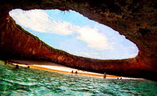
Mexico’s famed Hidden Beach (Playa Escondida), aka as the Beach of Love (Playa del Amor), has reopened for limited tourism following a three month closure for cleaning and restoration work.
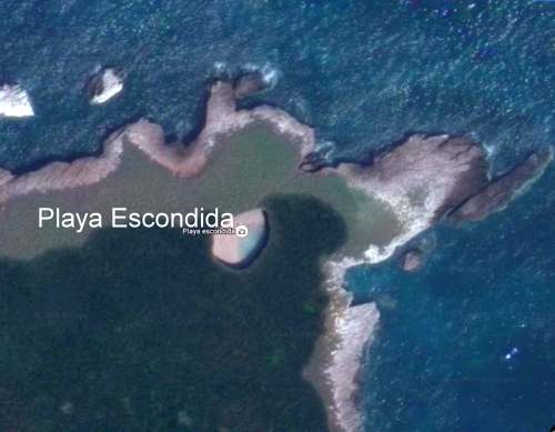
The beach is on one of the small, uninhabited Marieta Islands, in the Marieta Islands National Park, off the west coast of Mexico, and relatively close to the resort of Puerto Vallarta. It is one of Mexico’s most beautiful small beaches, looking from the air (image) like an “eye to the sky”.
Playa Escondida. Source: Google Earth. Scale: The beach is about 30 m (100 ft) long.
After a study by University of Guadalajara researchers found that local coral was dying and argued that the beach could support no more than 625 visitors a day (compared to the estimated 2500 who visit it on vacation days), federal authorities closed the beach and prohibited access while they considered how best to regulate future visits.
Mexico’s National Protected Areas Commission (Conanp) has now announced new regulations governing visits to the island and to the beach. It is limiting visitors to 116/day, well below the University of Guadalajara figure for carrying capacity of 625/day/.
In addition, no single group may have more than 15 members. No diving is allowed. Fins, face masks and snorkels are all prohibited. Visits have a strict time limit of 30 minutes. The beach, visted by more than 125,000 in 2015, will be completely closed two days each week for maintenance and monitoring.
Only time will tell if these measures will be sufficient to ensure that this particular gem of Mexico’s hundreds of amazing geosites will still be there for future generations to admire and appreciate.
State-owned Pemex currently has six oil refineries in Mexico, which process around 1.05 million barrels/day (b/d) of crude.
The company has now shelved plans to add a $10-billion refinery at Tula (Hidalgo) owing to doubts about its long-term viability. It does seem that it is unlikely to be needed since Mexico’s energy reforms have led to several private companies submitting proposals to build less expensive, modular “mini-refineries” in Mexico. Each of these mini-refineries is 80-90% smaller than any of the six giant Pemex refineries.
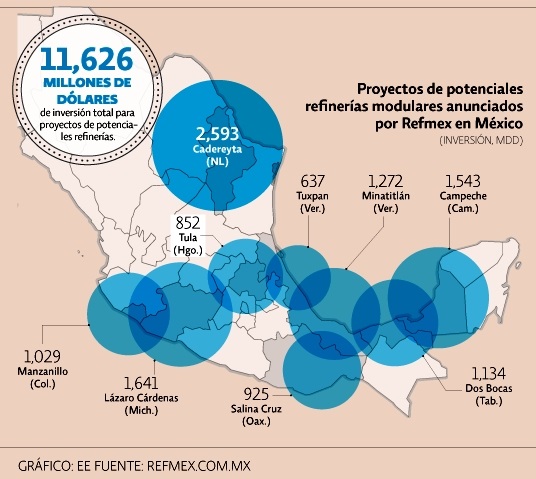
Planned new refineries. Credit: El Economista / Refmex.com.mx
A consortium of U.S. firms, Refinerías Unidas de México (Refmex), plans to invest 11.6 billion dollars to build 9 mini-refineries, starting with a $1.5billion refinery in Campeche with the capacity to refine between 40,000 and 60,000 b/d. Construction would take between 18 and 30 months.
Other proposed locations (map) include Cadereyta (Nuevo León), Dos Bocas (Tabasco), Minatitlán (Veracruz), Lázaro Cárdenas (Michoacán), Manzanillo (Colima), Salina Cruz (Oaxaca), Tula (Hidalgo) and Tuxpan (Veracruz). Several of these locations are in the recently announced federal Special Economic Zones, which offer fiscal incentives to investors.
Books and resourcesComments Off on Video of the Sea of Cortés (Gulf of California)
Aug232016
This PostandFly video explores the islands of San Jose, San Francisco and Espiritu Santo. The Sea of Cortés (Gulf of California) is the body of water that separates the Baja California Peninsula from the Mexican mainland. The Sea of Cortés is thought to be one of the most diverse seas on the planet, and is home to more than 5,000 species of micro-invertebrates. A large part of the Sea of Cortés is a UNESCO World Heritage Site.
Several rivers feed the Sea of Cortés, including the Colorado, Fuerte and Yaqui. The Sea of Cortés has more than 300 estuaries and other wetlands on its shores, of which the delta of the Colorado River is especially important. The vast reduction in the Colorado’s flow has negatively impacted wetlands and fisheries.
Previous Geo-Mexico posts on this area of Mexico include:
OtherComments Off on Mexico City declares public markets to be Intangible Cultural Heritage
Aug222016
Mexico has some of the finest markets in the world. The variety of produce and other items sold in markets is staggering. But not all Mexican markets are the same. The two major groups are the permanent markets (mercados), usually housed in a purpose-built structure and open for business every day, and the street market or tianguis, usually held once a week.
Earlier this month, Mexico City passed legislation that gave the city’s 329 public markets Intangible Cultural Heritage status, and provided additional funding to ensure that their traditional activities are maintained for future generations.
Some of the markets are traditional, mixed markets, others are specialized. Between them, they are used on a regular basis by almost half of Mexico City’s residents and provide more than 280,000 jobs. The Mexico City commission established to preserve these traditional spaces and their practices has been allocated a budget in 2017 of $200,000,000 pesos (about $11 million).
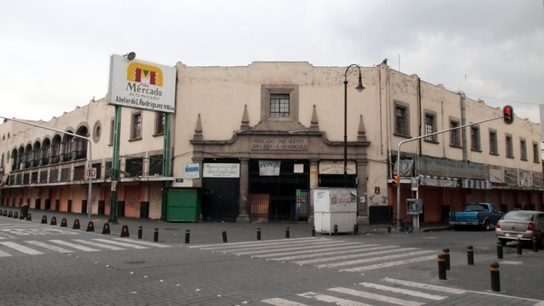
Abelardo L. Rodriguez Market. Credit: Wikimedia. Creative Commons.
Beyond their regular role as a trading place, many of the markets in Mexico City have additional claims to fame. For example the La Paz market in Tlalpan in the southern part of the city occupies an architecturally impressive building, while the Abelardo L. Rodríguez market in the downtown area has fine decorative murals painted by students of Diego Rivera.
Despite having seen this tourist promotion logo thousands of times, I had never thought about its colors and their significance until recently.
It turns out that the colors (despite what you may see on your monitor) are actually meant to be:
M – brown = archaeology and archaeological sites (historical tourism)
é – pink = health and well-being (including medical tourism)
x – yellow = culture (cultural tourism)
i – purple = meetings (seminars and conference tourism)
c – green = nature (adventure tourism and ecotourism)
o – blue = sea, sun and sand (beach and resort tourism)
The federal Tourism Secretariat is planning a nationwide overhaul of tourism signage on major highways taking advantage of these colors. It will install new, standardized signs using these six colors as a quick means of identifying the kind of tourist attraction at each location of interest. The program has funding of almost $10 million, and the first states to have the new signs will be Chiapas, Durango, Guanajuato, Hidalgo, Jalisco, Michoacán, Puebla, Tabasco, Tlaxcala and Veracruz.
Whether or not using six different colors is actually more effective than six distinct symbols on the same color background remains to be seen.
In the first half of this year, Mexico received 17,000,000 international tourists, 8.6% more than for the corresponding period in 2015, with expenditures by tourists rising 8% to $10.063 billion.
Avid Geo-Mexico readers will know that we included a few paragraphs about the Happy Planet Index in our 2010 book, which we later quoted in this 2013 post, Mexico and the Happy Planet Index.
The latest (2016) Happy Planet Index (HPI), which uses slightly modified criteria, shows that Mexico has risen to 2nd place in the world rankings, behind Costa Rica, but ahead of Colombia, Vanuatu and Vietnam and well ahead of the U.S. (#108) and Canada (#85).
The Happy Planet Index is a compound index that combines four measures:
life expectancy
well being (life satisfaction)
ecological footprint
inequality
The HPI looked at data for 140 countries. For life expectancy, Mexico ranked #39, for well being #11, for ecological footprint #77 and for inequality #60.
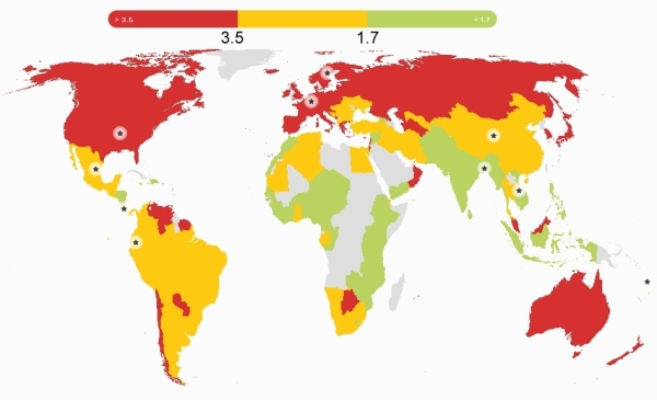
Global pattern of ecological footprint. Source: HPI report, 2016.
The world map for ecological footprint shows the global pattern. The colors show three categories for ecological footprints, those below 1.7, those between 1.7 and 3.5 and those that exceed 3.5, where the numbers are global hectares (gha) per person.
These two sections from the Happy Planet Index country report for Mexico are a useful snapshot of where Mexico stands right now:
What’s working well in Mexico?
In recent years, massive steps have been taken to improve the health of the population of Mexico – notably achieving universal health coverage in 2012, making essential health services available to the entire population.
In 2014, a tax was imposed on sugary drinks with the express aim of tackling of obesity – this despite strong corporate opposition. The tax had already led to a 12% decrease in the consumption of such drinks by the end of the year.
Environmental sustainability is receiving growing political attention, and was included as one of five key pillars in Mexico’s National Development Plan for 2007–12. Mexico was the second country in the world to incorporate long-term climate targets into national legislation, and is taking important steps to conserve its forests and protect its rich biodiversity.
What could be improved?
Significant challenges remain for Mexico: economic inequality is a massive problem with a considerable gap between the richest and poorest – the top 20% of the population earns more than thirteen times as much as the bottom 20% of the population.
Mexico’s poverty rates are particularly high among indigenous people. Amnesty International has highlighted Mexico’s human rights violations, especially relating to irregular migrants. On top of these issues, the importance of the oil industry to Mexico’s economy complicates its environmental efforts.
Mexico recently reached cross-party agreement on the Pacto por Mexico, a pact of 95 initiatives aiming to tackle some of these issues – an important step for the country’s future.
The HPI attempts to quantify an alternative vision of progress where people strive for happy and healthy lives alongside ecological efficiency in how they use resources. Mexico may have a high happiness index, but (like the rest of the world) it still has an awful long way to go to ensure a sustainable future for our grandchildren.
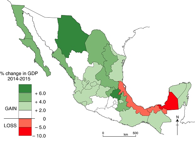
The map shows the percentage change in each state’s GDP during 2015. (Data from the National Statistics Agency, INEGI).
Change in GDP, by state, 2014-2015. Data: INEGI. Cartography: Tony Burton / Geo-Mexico
The fastest growing states in 2015 were Hidalgo (6.3%), Chihuahua (6.2%) and Nuevo León (5.9%).
While the economy of most northern Mexico states grew at a respectable rate during 2015, the economies of three Gulf coast states actually shrank last year, mainly owing to the drop in oil prices. GDP fell in three oil-rich states: Campeche (- 8.2%), Veracruz (- 2.3%) and Tabasco (- 0.2%).
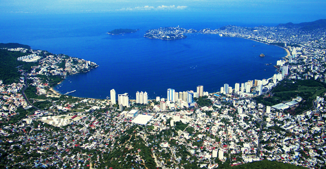
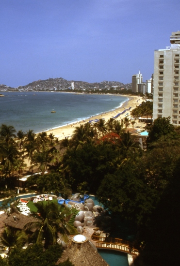
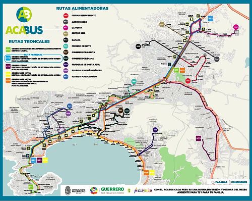
Acapulco is busy re-invigorating its tourist industry. In recent months, we’ve looked at the city’s improved public transit system known as Acabús and reported the news that Acapulco International Airport is getting a new, state-of-the-art, 18,800-square feet terminal building. The airport’s operator, Grupo Aeroportuario del Centro-Norte (GACN) says the 30-million-dollar terminal will be capable of handling 1.3 million passengers a year.
Now, Mexican firm Mundo Imperial, the tourist division of the vehicle financing firm Grupo Autofin, has announced a 1-billion-dollar Master Plan to help revitalize Acapulco, Mexico’s first jet set resort.
The plan aims to return the city to its former glory days by renovating the famed Mundo Imperial, Fairmont Princess and Pierre Marqués hotels, and adding several smaller boutique hotels and a medical center, as well as up-market homes and a high-end shopping plaza.
The project also includes an additional 700-room hotel, new tennis stadium, a hospitality training facility and an eco-adventure park. The plan, which will create around 10,000 jobs in total, will take five years to complete.
According to tourism officials, Acapulco’s reactivation as a tourist center is well under way. They claim that the port resort will host more than 40 major conferences this year, and that the city will be a port-of-call for more than 30 U.S. cruise ships.
Next year, Acapulco will once again host Mexico’s massive annual Tourism Fair, the Tianguis Turístico.
Index page, OtherComments Off on Index page: Mexico’s indigenous peoples
Aug042016
As the site continues to grow, in content and readership, we are adding the occasional index page to help new readers find articles of interest. According to the 2010 census, 6,000,000 Mexicans over the age of five speak at least one indigenous language. Another 3,000,000 Mexicans consider themselves indigenous but no longer speak any indigenous language.
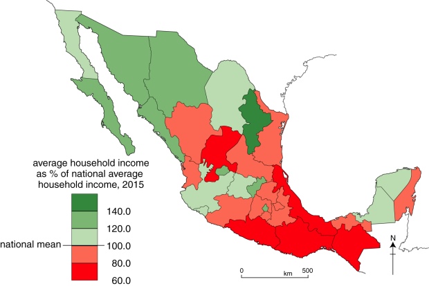
The National Statistics Agency’s (INEGI’s) 2015 Survey of Socioeconomic Conditions includes data for average household incomes in Mexico, on a state-by-state basis. The national average household income (for a three month period) is $45,887 (pesos) . The map below shows how each state’s average household income compares to the national average.
Household income, by state, 2015. Data: INEGI. Cartography: Tony Burton / Geo-Mexico
The state with the highest household income is Nuevo León, with $66,836, more than 140% of the national average. The state with the lowest household income is Guerrero ($27,584), where the average household income is only 60.1% of the national average. Guerrero’s average household income is only 41% of the average for Nuevo León.
As we have regularly highlighted in the past, regional differences in Mexico are considerable, and a definite “north-south divide”can be identified for almost every socio-economic variable. Development efforts need to be focused on improving the key indicators for southern Mexico and reducing these regional disparities.
The latest report on poverty from the National Statistics Agency, INEGI, looks like good news for Mexico’s poorest people but, sadly, this is only a mirage, based on a change in the measurement methods used.
The 2015 edition of INEGI’s Survey of Socioeconomic Conditions showed an overall real increase of 11.9% in household earnings, with an increase of over 30% in some states. According to the report, Mexico’s poor are richer by a third compared to last year, a change that some politicians will no doubt claim is the direct result of their effective policies.
Social activists were stunned by the claims of poverty reduction and Mexico’s National Council for the Evaluation of Social Development Policy (CONEVAL), which measures poverty levels using INEGI’s data, said the changes by the statistics institute were not credible.
According to Jonathan Heath, an independent economic researcher in Mexico City, Inegi is claiming that the previous methods overestimated poverty levels, but the change in methodology, without public consultation, “raises suspicion.”
Quite apart from the misleadingly positive spin on numbers, the change in methodology makes it completely impossible to compare current poverty rates with the rates for previous years.
We drew attention a few years ago to the issue of Empty houses in Mexico, a problem due in part to on-going rural-urban migration, and in part to the construction of millions of new homes across Mexico. Thirty years ago, there were only 15 recognized metropolitan areas in Mexico, today there are 59.
Poor coordination between the various government departments responsible for housing, services and land development has led to some settlements being authorized even in areas where ownership was disputed or that lacked adequate access to highways or basic services.
Three years ago, a Mexico City news report entitled Desorden urbano dejó en el país millones de viviendas fantasmas claimed that as many as 4 million houses, many of them newly built, were standing empty. Other houses have been abandoned for a variety of reasons, ranging from the death of former owners, or owners moving to other areas, or being unable to keep up with mortgage and loan payments.
Infonavit Housing. Credit: Habitat D.F.
News reports claim that as many as 14 houses in a single street are abandoned in some areas, such as the Mineral de la Reforma district of the rapidly-growing city of Pachuca in the state of Hidalgo, causing problems for neighbors.
Now, the Mexican Workers’ Housing Fund, Infonavit, has set itself the target of reclaiming 30,000 abandoned houses this year. Infonavit has funded hundreds of developments with small, cookie-cutter houses, across Mexico. Members of Infonavit can access a series of housing-related mortgage products, to buy or remodel a new or existing home.
Starting last year, Infonavit began to rescue abandoned houses, renovate them and then auction them off to its members. Initial success was limited, with only about half of the repossessed homes being sold on, but in the first few months of this year, Infonavit has successfully sold off 92% of the first 3,000 houses it has recovered.
This year, Infonavit plans to auction off homes in Chihuahua, Nuevo León, Tamaulipas, Hidalgo and the State of México.
OtherComments Off on 23 July: Happy Geographers’ Day! – ¡Feliz Día del Geógrafo de México!
Jul232016
Today, 23 July, is Día del Geógrafo de México or Mexican Geographers’ Day. See this earlier post for a brief history of why 23 July came to be chosen.
The community of geographers in Mexico has always been strong, and geographers are held in higher esteem in Mexico than in most countries. Online, for those speaking Spanish, the Facebook page of 23 de Julio: día del Geógrafo de México regularly has interesting links to publications, cartoons, photos and other resources.
One of my recent favorites is this great scenic landscape image from the Facebook page of Los Gastronautas:
Los Gastronautas: Landscape of ham and parsley
Geography is everywhere! A Happy Mexican Geographers’ Day to all geographers, whether in Mexico or elsewhere.
Geo-Mexico has dozens of posts about specific indigenous groups in Mexico. The tag system and the site search engine will locate short articles related to the Huichol, Tarahumara, Aztecs, Maya and several other groups.
Mexico's geography in the PressComments Off on Mexican business association tries to counter rhetoric of U.S. political campaigns
Jul142016
Mexico’s Business Coordination Council (Consejo Coordinador Empresarial, CCE) has launched a publicity drive to counter the disinformation and anti-Mexican rhetoric emerging in U.S. political campaigns. The details of the publicity drive remain unclear.
Juan Pablo Castañón, CCE’s president, says the aim is to emphasize the true strength and importance of good Mexico-U.S. relations. In particular, the NAFTA trade zone accounts for 15% of global trade, 28% of global GDP and 14% of FDI flows. Trade between the three partners has quadrupled since 1993 and exceeded a trillion dollars in 2015, half of which is attributable to U.S.-Mexico trade.
Mexico is the second most important destination for U.S. exports and the main market for exports from California, Arizona, New Mexico and Texas. Goods worth 500 million dollars cross the border daily.
According to Castañón, if U.S. politics puts a brake on this trade, more than six million U.S. workers could lose their jobs. Proposed tariffs on imports of flat screens and vehicles would raise prices significantly in the USA. In addition, 80% of avocados and 50% of tomatoes sold in the USA come from Mexico.
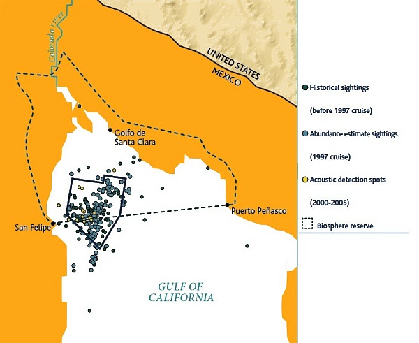
One year on from when we last reported on the desperate plight of Mexico’s “little sea cow”, the endangered vaquita marina, where are we now?
According to the World Wildlife Fund, “The vaquita is at the edge of extinction”. The latest population estimate suggests that the number of vaquita in the wild has fallen from about 100 in 2014 to just 60 today, despite a much-publicized ban on fishing in the main area where the little sea cows are found.
As we reported in Mexico’s “little sea cow” on the verge of extinction two years ago, the sea cow’s fate is inextricably tied to fishing for the (also endangered) totoaba, a fish in demand in China for its swim bladder, which is believed to have medicinal properties. Fishermen in Mexico’s Gulf of California (Sea of Cortés) are reported to have been offered more than $4,000 for a single totoaba bladder, which weighs only 500 grams. The price in China is reported to be between $10,000 and $20,000 each.
Map of sightings and acoustic detection spots. Adapted from North American Conservation Action Plan for the vaquita
In April 2015, federal authorities imposed a two-year ban on gillnets and expanded the vaquita protection area to cover 13,000 square kilometers (5,000 square miles) of the upper Gulf of California . Some 600 gill nets (each of which can be up to # meters long) were seized by the Mexican Navy in 2015 (and 77 individuals detained), and navy personnel claim they are still confiscating nets every day.
The International Committee for the Recovery of the Vaquita (CIRVA) is trying to make a difference. Among the options being considered by Mexico’s Environment Secretariat (Semarnat) is assisted breeding, though a vaquita expert, Barbara Taylor of the U.S. National Oceanic and Atmospheric Administration, is quoted in The Guardian as claiming that “We have no idea whether it is feasible to find, capture and maintain vaquitas in captivity much less whether they will reproduce. The uncertainties are large.” The World Wildlife Fund Mexico is currently opposed to such a strategy, given the very low number remaining.
Mexico has had conservation successes in the past, allowing the populations of other marine animals, including the Guadalupe fur seal and the northern elephant seal, to recover.
Acapulco international airport (ACA), in Guerrero state, currently handles about 800,000 passenger movements each year. The airport is operated by Grupo Aeroportuario del Centro-Norte (GACN), which also manages airports in another 12 cities. With suitable fanfare in 2014, GACN announced plans to replace the terminal building.
Acapulco, Mexico’s first major resort. Photograph by Tony Burton. All rights reserved.
Last month, GACN reiterated it is investing $30.5 million to build a new terminal building for Acapulco capable of handling 1.3 million passengers a year. The group claims that the new terminal, which will be more than 18,000 square meters in area, will have a state-of-the-art design that will reduce the risks associated with natural hazards and provide much greater space for passengers, airlines and all other supporting services. In addition, it will adopt a range of electricity-saving measures, lowering the airport’s regular operating costs.
Now scheduled to be completed by mid-2018, the Acapulco terminal is the most significant single investment that GACN plans to make in the next five years, and comes at a time when city authorities are busy revitalizing the famous resort. An improved public transit system known as Acabús was officially inaugurated in the city in June 2016.
The new terminal will, however, no longer be ready in time for 2017, when Acapulco will once again host Mexico’s massive annual tourism trade fair, the Tianguis Turístico.
A recent Bloomberg analysis highlights Mexico’s “Clean Energy Revolution”. The analysis of Mexico’s electricity sector finds that total energy demand will rise 72% over the next 25 years, from 305,000 GWh in 2015 to 512,000 GWh in 2040, while installed capacity will triple, to around 247 GW.
Fossil fuels are currently the source of 78% of the electricity generated in Mexico, but renewable energy (including hydro-power) will account for 69% by 2040.
According to Bloomberg, the costs of producing wind and solar energy will become fully competitive with electricity from natural gas power stations by 2025.
The report concludes that the renewable energy sector in Mexico represents an enormous investment opportunity, worth up to $186 billion between now and 2040.
The federal government is increasing its investments in research and development of renewable energy sources each year, up to $310 million in 2020, to build more “energy innovation centers” (Cemies). The five existing Cemies focus on geothermal, solar, wind, bioenergy and ocean energy respectively. Two new Cemies will investigate the use of intelligent networks and carbon capture alternatives.
Pemex has concluded a round of upgrades to its refineries which means that all fuels made in Mexico are now “clean” (ultra-low-sulfur). Pemex refineries produce 420,000 barrels of vehicle fuels a day, but national demand is for 800,000 barrels a day.
Imported fuels, which come mainly from refineries in Texas, already meet ultra-low-sulfur standards. The state oil giant has invested 1.7 billion dollars in modifying its six refineries to produce only ultra-low-sulfur fuels.
Despite some recent setbacks to hotel projects planned for the Caribbean side of Mexico, hotel building continues to gather pace elsewhere in the country, seemingly regardless of the long-term advantages and ecological value of retaining an undisturbed, or minimally-disturbed, coastline
In April, at Mexico’s major tourism trade fair, the Tianguis Turistico, in Guadalajara, authorities announced the go-ahead for Costa Canuva, a $1.8 billion tourism project in the state of Nayarit. The project is a joint venture between the federal tourism development agency, Fonatur, and Portuguese construction firm Mota Engil.
Costa Canuva is in the municipality of Compostela, and is situated about 65 km (40 mi) north of Puerto Vallarta international airport and will be under three hours driving time from Guadalajara once the new Guadalajara-Puerto Vallarta road is completed.
The 255 hectares (630 acres) of beach, estuary and mountains involved in Costa Canuva has 7 kilometers (4.3 mi) of beachfront, and was designated by Fonatur several years ago as the site for a purpose-built resort. The original version of the project, which never got off the ground, was known as Costa Capomo.
The revamped project, Costa Canuva, will add five hotels and more than 2,500 homes to this stretch of coast known as Riviera Nayarit. The first phase, expected to take three years and create more than 2,000 direct jobs, includes a luxury Fairmont Hotel, residential areas, and a golf course designed jointly by golf supertars Greg Norman and Lorena Ochoa.
The master plan for the project includes a beachfront village with 2,500 residential units, more than 20 kilometers of cycling tracks designed by the International Mountain Bicycling Association and an adventure park featuring canopy rides and ziplines.
The centerpiece Fairmont hotel will have 250 guestrooms and suites, more than 22,000 square feet of meeting and event space, six restaurants and bars, an expansive outdoor swimming pool and a massive spa, as well as a center for children and young adults.
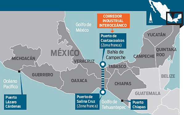
At the Mexico-China Forum for Cooperation in Mexico City in May 2016, authorities from China’s Guangdong Province met with Mexican officials and discussed plans to invest in Mexico’s recently-established Special Economic Zones.
These zones offer tax benefits and support services to investors in order to generate new sources of employment in southern Mexico (Guerrero, Oaxaca, Chiapas, Michoacán, Veracruz and Tabasco).
Trade between Guangdong Province and Mexico was worth $10.4 billion last year, 25% of the two countries’ total trade. Chinese firms are considering projects related to aerospace, vehicles, electronics and energy, which could add $480 million in foreign direct investment. In support of closer ties between Mexico and China, China Southern Airlines plans direct flights between Guangdong and Mexico starting next year, which would serve business travelers and also boost tourism.
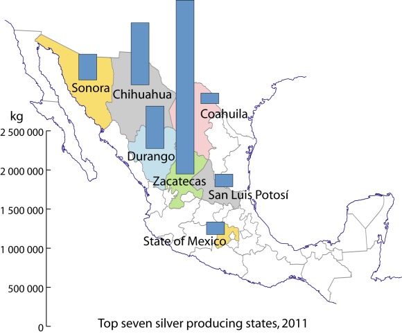
Mexico is the world’s leading producer of silver and has occupied top spot for several years. Mexico’s output of silver rose 2.0% in 2015 to 5,372 metric tons (189.5 million ounces). Mexico is responsible for 21% of global production, followed by Peru (15%), China (12%) and Australia and Russia (each 6%). About 70% of silver produced in Mexico is exported, the remainder is sold on the domestic market.
Global silver production fell slightly in 2015 due to decreased output from Canada, Australia and China. World demand for silver in 2015 reached a record 33,170 tons (1,170 million ounces), due to surges in three manufacturing sectors: jewelry, ingots and coins, and photo-voltaic solar panels.
The increased output in Mexico came from expansions in the Saucito and Saucito II mines, operated by Fresnillo, and the El Cubo mine, managed by Canadian firm, Endeavour Silver. A similar increase in production is predicted this year, given the on-going expansion of the San José mine, owned by Canada-based Fortuna Silver Mines.
Zacatecas is Mexico’s leading silver producing state (46.5% of total; see map), well ahead of Chihuahua (16.6%), Durango (11.3%) and Sonora (6.9%).
Silver production in Mexico, 2011. Data: INEGI. Credit: Tony Burton/Geo-Mexico
In Zacatecas, silver mining is especially important in the municipalities of Fresnillo(24% of total national silver production) and Mazapil (15%) as well as Chalchihuitesand Sombrerete(3% each). The main silver mining municipality in Chihuahua is Santa Bárbara (3% of national total). In Durango, San Dimas and Guanaceví are each responsible for about 3% of national production, while the leading municipality for silver in Sonora is Nacozari de García (1%).
The legacy of silver
The importance of silver mining in colonial New Spain can not be over-emphasized. For instance, during colonial times nearly one third of all the silver mined in the world came from the Guanajuato region!
Even today, the cities and landscapes of many parts of central and northern Mexico reveal the historical significance of silver mining. The legacies of silver mining include not only the opulent colonial buildings in numerous major cities such as Zacatecas and Guanajuato, as well as innumerable smaller towns, but also the deforestation of huge swathes of countryside.
The landscape of states like San Luis Potosí, Zacatecas and Guanajuato was forever changed by the frenzied exploitation of their woodlands. Silver mines needed wooden ladders and pit props. The smelting of silver ore required vast quantities of firewood. Barren tracts of upland testify to the success of those early silver mines. Mining played a crucial role in the pattern of settlement and communications of most of northern Mexico. The need to transfer valuable silver bullion safely from mine to mint required the construction of faster and shorter routes (see, for example, El Camino Real or Royal Road, the spine of the colonial road system in New Spain), helping to focus the pattern of road and rail communications on a limited number of major cities.
Once workable ores ran out, smaller mining communities fell into obscurity and many became ghost towns. Some of these settlements, such as Real de Catorce and Angangueo, have enjoyed a new lease of life in recent years due to tourism.
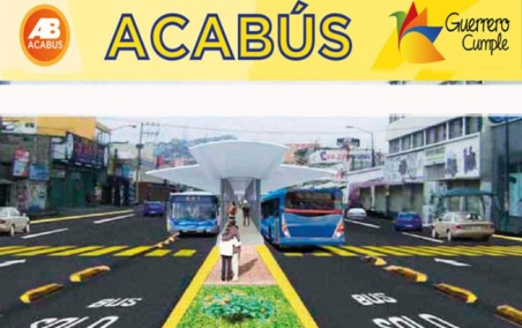
OtherComments Off on Acapulco’s ACAbus system finally begins operations
Jun162016
On 21 June, the public transit system known as ACAbús will finally officially begin operations in the resort city of Acapulco in Guerrero. ACAbús began trial operations on 31 May, following several years of delays.
The service employs 135 Dina buses of various kinds, all equipped with state-of-the-art technology to reduce emissions, save fuel and will substitute 366 old, less efficient vehicles to the benefit of both locals and tourists.
The system represents an investment of around $140 million, roughly two-thirds for highway and transit stop refurbishment and one-third for operating equipment (vehicles and travel card machines).
ACAbús connects the resort’s many tourism attractions and facilities. The main central axis (map) is a 16-km (10 mile) long route from Las Cruces along Avenida Cuauhtémoc to Caleta, with 18 stops along the way. This portion will be confined solely to rapid transit articulated buses.
Map of ACAbús network; click for larger pdf map
Four trunk routes supplement this central axis, each with a limited number of stops. The ones of interest to most tourists will be Routes 4 and 5, which run along the main Costera Miguel Alemán highway. A series of shorter feeder routes provides easy access from most parts of the city to the nearest trunk route.
Passengers are required to obtain a pre-paid card in order to use the system. Most journeys, including connecting service, will cost $10 pesos (less than 60 cents U.S.).
The number of different bus routes in Acapulco has been reduced from about 220 to 120, but travel times should be greatly improved. Authorities claim that the system should cut regular traffic by about 25%, and that everyone will benefit as it means that older vehicles have been removed from the roads with a decrease in total emissions.
Mexico’s national electrical system serves about 97% of all Mexicans. In recent years electrical generation has not been able to keep pace with demand for electricity, which is increasing at about 6% to 7% per year. Attempts to increase private sector investment in energy as a means to keep up with surging demand have met opposition in the Mexican Congress. Under current law, private investors may generate electricity but transmission and distribution are restricted to the Federal Electricity Commission.
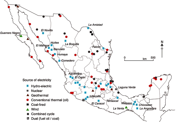
Mexico’s major power stations. Fig 16-2 of Geo-Mexico; all rights reserved.
About 30% of Mexico’s total installed electricity generating capacity of 60,000 MW comes from conventional power plants burning oil. Natural gas-fueled power plants account for about 35%, while coal plants contribute about 9%. Altogether, fossil fuel burning facilities account for almost three-quarters of Mexico’s generating capacity.
Many of Mexico’s newer power plants are highly efficient, gas-fired, combined cycle plants which integrate gas and steam turbines. On a per megawatt basis, they are relatively economical to build. Their major disadvantage (equally true for conventional thermo-electric power stations) is that their emissions contribute to air pollution (particularly sulfur dioxide) and global warming. About 25% of Mexico’s annual emissions of carbon dioxide are due to electricity generation.
Hydroelectric power has been important since the early part of the twentieth century. Currently about 22% of the electricity generating capacity is from hydroelectric plants. The largest hydroelectric plants are on the Grijalva River in Chiapas. Other rivers providing significant hydropower are the Balsas, Santiago, Fuerte, Papaloapan and Moctezuma.
Mexico has one nuclear power plant at Laguna Verde in Veracruz, which provides about 2.6% of the nation’s generating capacity. No additional nuclear plants are planned.
Mexico has the world’s second largest geothermal electrical potential, after Indonesia. This resource might be more important in the future but at present it accounts for less than 2.4% of Mexico’s electricity capacity.
The region of Mexico with most potential for wind power is the low-lying and flat Isthmus of Tehuantepec in southern Mexico where annual wind speeds, at a height of 30m (100 ft) above the ground (the height of modern windmills), average more than 30 kph (19 mph). Despite the success of the windfarms already operating in La Venta (Oaxaca) and Guerrero Negro (Baja California Sur), wind power is responsible for less than 0.05% of all electricity. The government hopes to boost wind power capacity significantly within the next five to ten years.
Most solar power interest is focused not on large scale plants but on small-scale photovoltaic (PV) systems providing electricity in remote rural areas. About 3 million people (3% of the population) live in small or remote settlements not yet connected to the national electricity grid. More than 60,000 PV systems have been installed nationwide, benefiting 250,000 rural inhabitants.
Index pageComments Off on Migration and remittances: an index page
Jun092016
Remittances (the funds sent by migrant workers back to their families) are a major international financial flow into Mexico. Remittances brought more than 24 billion dollars a year into the economy in 2015, an amount equivalent to about 2.5% of Mexico’s GDP.
For an introduction, with links to some of the key pages on this blog, see
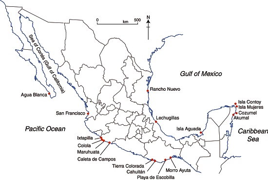
On Mexico’s Pacific coast, the endemic Green Turtle or tortuga verde (Chelonia mydas) has been taken off the “endangered” list and had its status reclassified as “threatened”. Despite the success of conservation efforts in Mexico, green turtle remains on the worldwide endangered list, to which it was first added in 1978.
The global population of green turtles, which can wiegh up to 200 kg and live as long as 80 years, has now been divided by wildlife experts into 11 distinct sub-populations, allowing some flexibility in approaches to their management.
Selected marine turtle nesting beaches in Mexico.
Meanwhile, in Mexico’s arid northern interior in the Chihuahuan desert, biologists have reported a marked upsurge in the numbers of the very much smaller Bolson tortoise. The Bolson tortoise (Gopherus flavomarginatus), native to this part of Mexico, is often referred to as the Mexican giant tortoise, but grows only to about 50 cm in length, with a weight of around 18 kg. It had been under threat due to local people hunting it for food, and due to shifting weather patterns. The tortoise is one of the various endangered species inhabiting the Bolsón de Mapimi, the desert basin that straddles the borders of Durango, Coahuila and Chihuahua.
Conservation efforts in the area have focused on ensuring that local people have an alternative source of meat (cattle in this case) and appreciate the value of preserving their native tortoises. Local communities have been given grants to help with reforestation projects, environmental monitoring and maintaining a small museum for visitors.
OtherComments Off on How was Playa Escondida (“Hidden Beach”) formed?
Jun022016
Following on from our look at the potentially disastrous environmental consequences of publicizing Playa Escondida (“Hidden Beach”), one of Mexico’s most beautiful small beaches, we take a look at how this extraordinary beach was formed.
Playa Escondida. Source: Google Earth. Scale: The beach is about 30 m (100 ft) long.
Playa Escondida is on one of the small, uninhabited Marieta Islands, in the Marieta Islands National Park, off the west coast of Mexico, and relatively close to Puerto Vallarta.
The beach is an “eye to the sky” and is aptly described by travel writer Brandon Presser, as follows:
At the center of Isla Redonda [is] a quirk of nature seen only on the pages of a fantasy novel—a sandy beach carved into the rounded core of the island like the hole of donut. Although completely invisible from the shoreline, a bird’s eye view reveals lapping crystal waters and an empty dune like dazzling colors at the end of kaleidoscope’s funnel.”
The Marieta Islands are formed of volcanic rocks and are an extension of Mexico’s Volcanic Axis.
Just how was this beach formed? Prosser describes two alternative suggestions. The first is that the volcanic rocks were not uniform in composition and hardness but had differences in resistance to subaerial weathering and erosion. According to this theory, the weaker, less consolidated rocks were eroded more quickly than the surrounding rocks to leave a giant chasm in the ground. This chasm was then breached on one side by marine action.
The alternative theory mentioned by Prosser, and the only one mentioned (though without citation) by wikipedia, is that the chasm was formed by human activity, specifically by the Mexican military who undertook bombing practice in and around the islands prior to when the area was given National Park status.
Coastal geomorphologists might argue the case for considering a third theory, involving the formation, first, of the cove on the outer coast of the island, followed by a combination of marine and subaerial action to exploit a line of weakness in the volcanic rocks to create a landform known as a geo (a narrow, deep, cleft extending inland from the coast). This geo may have gradually lengthened over time, by continued cave formation at the head of the geo, with marine erosion at the back of the cave opening up a blowhole, a small opening to the sky. A sequence of collapses and blowhole formation, over time, may have created Playa Escondida, where the interior beach is the base of a former blowhole, where the roof has collapsed and the material subsequently removed by marine action or pounded into beach sand.
Whatever the explanation, this particular geomorphosite is one of Mexico’s many natural treasures, and one well worth preserving for future generations.
OtherComments Off on Novelist Charles Fleming Embree, an honorary geographer
May302016
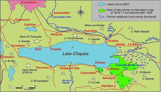
American author Charles Fleming Embree‘s A dream of a throne, the story of a Mexican revolt, published in 1900, is, I believe, the earliest novel in any language about the Lake Chapala area. It is an historical novel, set in the area during the nineteenth century, but Embree reveals an extraordinary depth of knowledge, not only of the history of this area, but also of its geography.
Embree was only 24 years of age when he and his wife Virginia, newly-weds at the time, arrived in Chapala in 1898. Embree had dropped out of Wabash College in his native Indiana, without completing his degree, to devote himself to his writing and his first book, a collections of stories entitled For the Love of Tonita, and other tales of the Mesas (1897) had proved successful.
The Embrees lived in Chapala for eight months in 1898, before traveling to other parts of Mexico, including Guanajauto, Xalapa, Cuernavaca and Oaxaca. Embree’s publishers described A dream of a throne as, “A powerful and highly dramatic romance, dealing with a popular Mexican uprising half a century ago. It is a novel of adventure and of war, and its strongly contrasted characters glow with life and realism. The writer’s thorough knowledge of Mexican life gives him a wealth of new material; and the descriptions of scenery at Lake Chapala are vivid, full of color, and alive with mountain air”.
A Dream of a Throne by Charles F. Embree
The book is indeed a remarkable achievement. Despite only living at Lake Chapala for a few months, Embree acquired and demonstrates, from a geographical perspective, an extraordinarily accurate and astute knowledge of all his lakeside locales. The spelling of all place-names, with the exception of Ajicjic and Tuxcueco, is exactly as it is today. Details of clothing, habits and customs all ring true. Embree’s knowledge of the region’s nineteenth century history is equally impressive. As one small example, the story begins in the shadow of St. Michael’s hill in Chapala in May 1833, amidst fear of an epidemic of smallpox. In real life, the nearby city of Guadalajara suffered a cholera epidemic in the summer of 1833.
From a human geography perspective, this novel offers us one of the earliest descriptions of everyday indigenous life in the region. As Dr. Wolfgang Vogt of the University of Guadalajara has pointed out, even by the 1920s (twenty years after Embree’s novel), virtually no-one was observing or writing about this area from an indigenous point of view. Embree’s novel has particular value since it examines the conflicts between Indians and Spaniards, anticipating the themes explored by D. H. Lawrence when he visited Chapala for a couple of months in 1923 and penned the first draft of The Plumed Serpent.
All the action in Embree’s novel takes place on and around Lake Chapala. The major locales are Mezcala Island, Chapala, Ajijic and Tizapan. The following extracts have been chosen to highlight his depictions of the local landscapes. Lake Chapala was significantly larger in 1898 than it is today (see The eastern end of Mexico’s largest lake, Lake Chapala, is amputated):
Lake Chapala, showing area drained at start of 20th century. Map: Tony Burton. All rights reserved.
Here is Embree’s description of Ajijic:
They were riding over a rough trail with cacti and stones about, and here and there a flock of goats. To the right was a seemingly endless chain of mountains, to the left, more distant, rose St. Michael, low and round (behind whose bulk lay Chapala and the water), and the larger head, called Angostura, lying between that town and Ajicjic on the lake’s edge. Between Angostura and the opposite mountain chain the road led, rising to a hill, to whose summit the little army came. They looked down on the lake and, nearer, small irregular fields, scores of them, checkering a level stretch from mountains to water. Out of these, Ajicjic’s church thrust up a single gleaming tower of white. Three o’clock found the troop sweeping into the barren plaza of that fishing village.
To this day Ajicjic can claim no more than some two thousand souls. It has, even yet, no railroad, no stage; rarely has a vehicle been seen in that primitive place other than the awkward oxcart. Its low, unplastered adobe walls stand close together. The streets are alleys of extreme narrowness wherein there is mud when it rains, dust when it is dry, rocks and swine forever. Nigh every alley twists and turns, is for a block no more than a gutter, for another block a public stable for burros. Yet one may find some better quarters. The plaza, though it is only a bare, brown waste, is wide. The open court before the church, though it too is bare and dirty, with lonely, crumbling walls and pillars about it, yet has in its center a weather-beaten cross that speaks of service to the Lord.
The troop filled the plaza. It was halted, and the inhabitants of the town, struck with amazement, either shut themselves up or gathered in silence round about. Groups of brown children, absolutely naked, sat down in the dirt, thumbs in mouth, to wonder in comfort. Rodrigo and Bonavidas began the inquiries, prefacing them with jocularly expressed friendship to certain storekeepers and a toss of tequila here and there down a willing throat. Boats? There hadn’t come but one boat to Ajicjic the blessed day. Ajicjic was losing importance in these times. On market days everybody went to the bigger market at Chapala, where the news was dispersed. And this one boat? It had come from Tizapan with a load of wood for the lime burners.
His landscape descriptions are equally adept:
The town of Tizapan lies at a short distance from the lake. The shore in that region is no such distinctly marked line of beach and rock as it is at Chapala. It is not even always easy to tell where the shore is. Between water and land there is a stretch of marsh for several hundred yards, watery, pierced by the spears of a million reeds that rise thick and green to a height of some feet. Here flock ducks in great numbers. The marsh is flat, bewildering, and dreary. Through its middle a stream, called the Tizapan River, cuts out more than one course, having formed a delta. The main course of this river, not over twenty yards at its widest part, usually much narrower, is navigable for canoas for half a mile to a point where the land is dry and from which the town lies yet another mile distant. The stream being crooked and the curves sharp, the progress from the open lake to the inner landing is usually made by poles. The lake approach to the town could be easily blocked by blocking the river. Only the one course is navigable. Nobody could cross the marshes. This fact was recognized more than a century ago.
The town itself is like the greater part of Mexican towns, narrow and crooked streets with the low houses (joined together) shutting those streets in and making them seem even narrower, and the central plaza of considerable size left vacant. That plaza is today filled with flowers and fruit and contains a bandstand. In former times it was bare. The mountains rise only a little way behind the town, jagged and huge. Before them is a stretch of rolling green fields. The river, coming from the peaks, dashes down through this pastoral scene with a vivacity that has laid bare a rough and rocky bed whereon the water boils till it passes through the town. At the time when the two small armies were approaching Tizapan, much of the summer green was still on field and mountain. The unclouded sun poured his light over an emerald gem of the lake’s border.
After their time in Mexico, the Embrees settled in Santa Ana, California. Embree published his second novel A Heart of Flame: the Story of a Master Passion in 1901, and supplied a steady stream of short stories to major magazines, including McClure’s, the San Francisco Argonaut and Sunset Magazine. Sadly, the couple had not long celebrated the birth of their only daughter Elinor in 1905 when Embree was taken seriously ill. He died on July 3, not yet 31 years old.
It is tragic that someone who had produced work of this magnitude, should have died so terribly young. In his short time in Chapala, Charles Embree had acquired an excellent historical and geographical knowledge of the region at a time when American travelers to the lake were few and far between. Geo-Mexico believes that Charles Fleming Embree fully deserves to be declared an Honorary Geographer.
Mexico’s largest mining company, Grupo México plans to mine copper from its mine in Angangueo, Michoacán, according to the town’s mayor, Leonel Martínez Maya, who says it would revitalize the local economy. Large-scale mining in the town declined after a serious accident in 1953, said to have been attributable to the company’s then-foreign management in response to a threatened strike. The miners who lost their lives in this accident are commemorated by a huge statue which overlooks the town.
Angangueo. Sketch by Mark Eager; all rights reserved.
The mayor is adamant that the renewal of active mining in the town would have no adverse consequences for the annual migration of Monarch butterflies (who overwinter in their tens of millions in the pine-fir forests above the town) or on their habitat.
The town is one of Mexico’s “Magic Towns” and the area is a protected natural reserve, but apparently the mining company is taking advantage of a legal loophole and arguing that the mine predates the establishment of the Monarch reserve, and that the mine was never technically closed, even though it was inactive in recent years. The Michoacán state government is said to support the Grupo México initiative.
Despite boom times in the past, the town of Angangueo currently has only limited sources of revenue other than seasonal tourism.
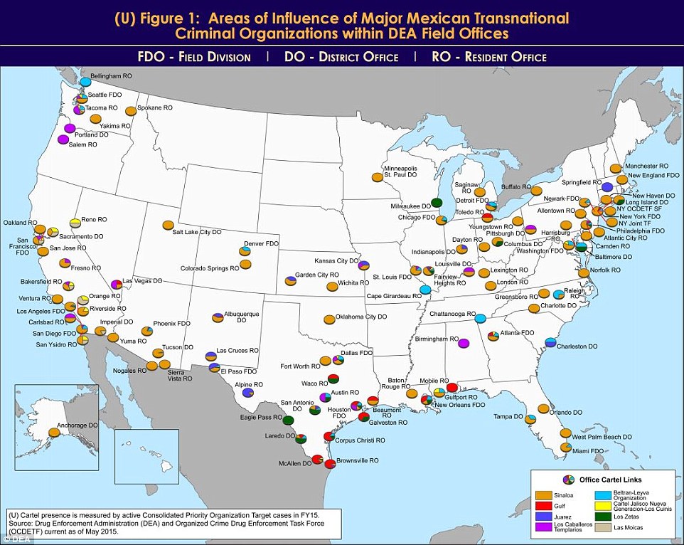
An unclassified DEA Intelligence Report from a year ago has just resurfaced on my desk. Entitled United States: Areas of Influence of Major Mexican Transnational Criminal Organizations, it includes two particularly interesting maps.
The report states that “Mexican transnational criminal organizations (TCOs) pose the greatest criminal drug threat to the United States; no other group is currently positioned to challenge them. These Mexican poly-drug organizations traffic heroin, methamphetamine, cocaine, and marijuana throughout the United States, using established transportation routes and distribution networks. They control drug trafficking across the Southwest Border and are moving to expand their share, particularly in the heroin and methamphetamine markets.”
As of May 2015, the DEA identified the following cartels that operate cells within the USA: the Sinaloa Cartel, Gulf Cartel, Juarez Cartel, Knights Templar (Los Caballeros Templarios or LCT), Beltran-Leyva Organization (BLO), Jalisco New Generation Cartel (Cartel Jalisco Nueva Generacion or CJNG), Los Zetas, and Las Moicas.
The maps reflect “data from the Organized Crime Drug Enforcement Task Force (OCDETF) Consolidated Priority Organization Target (CPOT) program to depict the areas of influence in the United States for major Mexican cartels.”
DEA-Mexican cartel influence in USA
Figure 1 (click map to enlarge) shows the distribution of DEA Field Offices. The pie chart for each office shows “the percentage of cases attributed to specific Mexican cartels in an individual DEA office area of responsibility”.
“Since 2014, the Arellano-Felix Organization, LCT, and the Michoacán Family (La Familia Michoacán LFM) cartels have been severely disrupted, which subsequently led to the development of splinter groups, such as, “La Empresa Nueva” (New Business) and “Cartel Independiente de Michoacan” (Independent Cartel of Michoacan) representing the remnants of these organizations.”
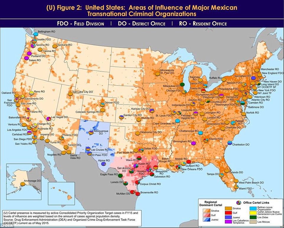
Figure 2 (below) shows the dominant transnational criminal organization (TCO) in each domestic DEA Field Division, relative to other active TCOs in the same geographic territory. The map includes population density shading which “is intended to depict potential high density drug markets that TCOs will look to exploit through the street-level drug distribution activities of urban organized crime groups/street gangs.”
DEA-Mexican cartel influence in USA
“The Sinaloa Cartel maintains the most significant presence in the United States. They are the dominant TCO along the West Coast, through the Midwest, and into the Northeast. While CJNG’s presence appears limited to the West Coast, it is a cartel of significant concern, as it is quickly becoming one of the most powerful organizations in Mexico, and DEA projects its presence to grow in the United States over the next year. In contrast, Mexican cartels such as the Gulf, Juarez, and Los Zetas hold more significant influence closer to the Southwest Border, but as shown on the map, their operational capacity decreases with distance from the border.”
Other, smaller, “splinter groups from the disrupted LCT organization continue to traffic drugs from the Michoacán, Mexico area into the United States. The BLO, former transportation experts for the Sinaloa Cartel, is most active along the East Coast and is also responsible for the majority of heroin in the DEA Denver area of responsibility. Las Moicas is a Michoacán-based organization with former LFM links, but remains a regional supplier in California and operate on a smaller scale relative to other major Mexican TCOs.”