Mexico City’s Ecobici cycle rental system enters its fifth year

 Mexico's geography in the Press  Comments Off on Mexico City’s Ecobici cycle rental system enters its fifth year
Feb 202014
 

Mexico City’s Ecobici system for public bike rentals in and around the city’s historical center celebrated its fourth birthday in February 2014. The system, established in 2010, currently has more than 60,000 24,000 registered users; between them they have already surpassed 13.5 million short trips by Ecobici. City officials calculate that the system has saved 499 metric tons of CO2 since 2010.

Ecobici bike rack
Annual membership currently costs 400 pesos (about 31 dollars). It is also possible to buy membership for a single day (90 pesos), three days or by the week. The system is intended for short trips. With membership, the first 45 minutes of each ride is free.

There are 275 Ecobici cycle stations and 4,000 Ecobici bikes in circulation. The current level of usage is 25,000 trips each day. The average trip distance per ride is 8 kilometers (5 miles), the average trip time is 20-25 minutes; 80% of users are male, and the average ride saves 7.5 kg of atmospheric emissions. Four out of five riders start or end their trip with a ride by bus, taxi, car or metro. City authorities intend to add Ecobici to the Tarjeta Ciudad travel card that can be used to pay for other forms of city transport including the Metro and Metrobús networks.

Is there a down side?

Criticisms of Ecobici have been relatively minor. Initially, some riders complained that the cycle racks were sometimes completely full, meaning they had to cycle to an alternative cycle station where there was space to leave their bike, or that a cycle rack had no bikes to rent, in which case they had the inconvenience of finding another cycle station that did have bikes. Ecobici’s organizers regarded these issues as normal “teething problems” for any system of this scale, and this sort of complaint is now unusual. Authorities hope to implement a system at some point in the future which allows users to receive, via cell phone, real-time information about where bikes are available.

Other road users have complained that some of the Ecobici riders ignore traffic rules by, for example, cycling the wrong way down one-way streets, increasing the chance of an accident.

Area served by the Ecobici system

The 21 square kilometer area served by Ecobici includes the Historic Center of Mexico City and the following neighborhoods (colonias) in the Miguel Hidalgo and Cuauhtémoc districts (delegaciones):

  • Anzures
  • Condesa
  • Cuauhtémoc
  • Escandón
  • Guerrero
  • Juárez (including theZona Rosa)
  • Polanco
  • Roma Norte
  • Roma Sur
  • San Miguel Chapultepec
  • San Rafael
  • Tabacalera

Expansion plans

The city government is now expanding the system by 14 square kilometers into the Benito Juárez district, where 171 new bike stations will be located in 22 neighborhoods, including Del Valle and Narvarte. The new cycle stations being installed allow allow casual users and tourists to pay for each individual trip by credit card.

Related posts:

Mexico’s drug cartels and their areas of operation, a 2014 update

 Mexico's geography in the Press, Updates to Geo-Mexico  Comments Off on Mexico’s drug cartels and their areas of operation, a 2014 update
Feb 172014
 

As noted in previous updates on Mexico’s drug cartels and their shifting areas (and methods) of operation, it is becoming ever harder to keep up-to-date with the geography of drug cartel territories. The current federal administration has deliberately limited the amount of hard data relating to drug violence published on government sites or in Mexico’s mainstream press. While this may help to reduce public unease at the levels of drug-related crime, it also means that it has become much harder to analyse the situation and determine overall patterns and trends.

The 2013 UN Global Report on Drugs estimates that Mexico is Latin America`s largest drugs producer, making 30 times more heroin than Colombia. The report also cites statistics showing that more methamphetamine are confiscated in Mexico than in the rest of the world combined.

Previous updates:

The main players  (February 2014) are:

  1. Los Zetas, operating in more than half of Mexico’s 32 states (more territory than their main rivals the Sinaloa Federation), and prone to extreme violence. They have branched out into human trafficking and extortion to support their drug smuggling operations. They control much of eastern Mexico. Even the capture of their top leader in 2013 does not appear to have significantly weakened their internal cohesion.
  2. Sinaloa Federation, which remains in control of most of western Mexico, and increasingly specializes in the production of methamphetamine. The cartel is led by Joaquín “El Chapo” Guzmán, whose estimated personal net worth exceeds $1 billion dollars according to Forbes magazine. Guzmán escaped from a high secrutiy jail in 2003 but was recaptured in Mazatlán in February 2014.
  3. Gulf Cartel, still important along Mexico’s Gulf coast, but weakened due to infighting, captures of leaders, and conflicts with Los Zetas.
  4. Knights Templar (Los Caballeros Templarios), started in 2010 by former members of The Michoacán Family (La Familia Michoacana), and which now controls much of the drug-related activity in Michoacán and Guerrero. They are in near-constant conflict with the Jalisco New Generation Cartel (based in the neighboring state of Jalisco) which has resulted in continued violence along the Jalisco-Michoacán border.

Smaller, regional players:

  1. Tijuana Cartel, operating in the city of Tijuana on the Baja California/California border.
  2. Juárez Cartel, now largely limited to Cd. Juárez and the border with Texas. Mexican federal police say this group now calls itself the New Juárez Cartel (Nuevo Cartel de Juárez).
  3. Jalisco New Generation Cartel (Cartel Jalisco Nueva Generación), based in the state of Jalisco and thought to operate as enforcers for the Sinaloa Federation
  4. Cartel del Pacífico Sur; weak, and competing with Zetas, mainly in the central Mexico state of Guerrero
  5. Independent Cartel of Acapulco, small and apparently declining in importance

Splinter groups (see below):

  1. Sangre Z
  2. Golfo Nueva Generación
  3. La Corona
Cartel areas and drug routes in Mexico

Cartel areas and drug routes in Mexico, 2012. Copyright Stratfor. Click map for enlarged version

Recent changes (2013-2014)

Early in 2013, Mexico’s National Security Cabinet revealed the emergence of several new drug trafficking organizations. The new groups–Sangre Z, Golfo Nueva Generación, and La Corona– are splinter groups from Los Zetas, the Gulf Cartel, and the Sinaloa Federation respectively. The new groups formed in response to the arrest of key operatives in the large cartels. These new groups are reported to be well equipped and well-armed, generating revenue through drug trafficking and by levying protection payments on other drug traffickers who pass through their turf on their way to the USA..

In 2013, the situation in the western state of Michoacán became particularly unstable with drug-related violence (shootouts, roadblocks and the torchings of vehicles) perpetrated by the Knights Templar in many parts of the state. The town of Apatzingan in the Tierra Caliente region of Michoacán is the main bastion of the Knights Templar organization. The increased violence resulted in the well-publicized rise of civilian “vigilante” militia groups (community self-defense groups), prepared to take on cartel members in direct combat in their efforts to reduce the incidence of extortion, kidnappings and other crimes. Self-defense groups sprang up in more than 30 municipalities in Michoacán including at least 15 of the state’s 113 cities. Places with self-defense groups included Buenavista Tomatlan, Coalcoman, Tepalcatepec, Los Reyes, Aquila, Paracho, Cheran, Tancitaro, Paracuaro and Nueva Italia.

For a good summary account of the struggle between the Knights Templar and the vigilantes, see Mexican Vigilantes Beat Back Ruthless Knights Templar Cartel by journalist Ioan Grillo. We will take a closer look at the Knights Templar in a future post.

In recent months, in the wake of drug gang attacks on gas stations and electricity facilities in Michoacán, the federal government has stepped up its attempts to resolve the security problems in the state. In some places, it has replaced city officials and local police forces en masse. In the important Pacific Coast port of Lázaro Cárdenas (a main port of entry for the chemicals used for methamphetamine production, and a main export port for minerals, one of the more lucrative sources of income for the Knights Templar), the federal government sent in the military to administer the port.

In their efforts to curb the rise of civilian militia groups, the federal and state governments have announced a scheme which allows militia members to register to join new, state-controlled Rural Protection Forces (RPF). As of early February 2014, about 500 “self-defense” members had already registered to join the RPF.

The federal government has also announced the creation of a 3.5-billion-dollar purse to support 250 specific actions in Michoacán designed to reactivate the state’s economy, reinforce security and aid its social assistance programs.

Related posts (chronological order):

Feb 152014
 

Kudos to The Economist for its short piece entitled “Old Mexico lives on” in which it points out that Mexicans and their descendents are gradually reoccupying the territory that the USA gained from Mexico in the nineteenth century. The evidence is provided by the map (below) showing “Mexican-origin population” by county for the USA. The definition is by ethnicity (origin), not citizenship.

Mexican-origin population living in USA. Source: Economist, 1 Feb 2014.

Mexican-origin population living in USA. Source: Economist, 1 Feb 2014. Click to enlarge.

In February 1848, Mexico was forced to cede more than half its territory to the USA. The area handed over included most of present-day Arizona, California, Nevada, New Mexico and Utah, plus parts of several other states. (Texas had declared its independence from Mexico in 1836).

Note the close correlation between areas that were part of Mexico prior to 1848 and those that now have the highest numbers of residents of Mexican-origin. As The Economist points out, “communities have proved more durable than borders”. Mexican migrants have been preferentially attracted to areas that were originally Hispanic, and where some residents can “trace their roots to long before the map was redrawn”. As The Economist concludes, “They didn’t jump the border—it jumped them.”

Related posts:

The pattern of violent crimes in Mexico in 2013

 Mexico's geography in the Press, Updates to Geo-Mexico  Comments Off on The pattern of violent crimes in Mexico in 2013
Feb 082014
 

The Consejo Ciudadano para la Seguridad Pública y la Justicia Penal AC, a Mexican non-profit, has published an interesting report looking at the levels of violent crime in Mexico in 2013:

The authors take violent crimes to include intentional homicide, kidnapping, rape, aggravated assault, robbery with violence and extortion.

At the municipal level, violent crime is concentrated in a relatively small number of municipalities. The report looks at the statistics for the 216 municipalities (including delegaciones of the Federal District) that had estimated populations of over 100,000 in 2013. Since 2012, four municipalities have joined this group: El Fuerte (Sinaloa), Tepotzotlán (México), Pánuco (Veracruz) y Playas de Rosarito (Baja California). Between them, the 216 municipalities are home to about 64% of Mexico’s total population.

Data from government agencies and INEGI were used to compile rates for each crime in each municipality. These rates were then multiplied by the following weightings (to reflect the relative severity and impacts of each type of crime),

  • 0.55 for intentional homicide
  • 0.22 for kidnapping
  • 0.13 for rape
  • 0.04 for aggravated assault
  • 0.03 for robbery with violence
  • 0.03 for extortion

and summed to give an overall index for “violent crimes”.  For the 231 municipalities, the index ranged from 106.63 for Oaxaca, Oaxaca to 0.00 for Zapotlán el Grande in Jalisco. The full details of the methodology are explained and discussed in the report. A similar methodology was also used to calculate levels of violence by state.

The worst 10 municipalities in terms of violent crime were:

  1. Oaxaca, Oaxaca – violent crime index value of 106.63
  2. Acapulco, Guerrero – 80.35
  3. Cuernavaca, Morelos – 65.30
  4. Yautepec, Morelos – 56.19
  5. San Pedro, Coahuila – 53.42
  6. Cd. Victoria, Tamaulipas – 52.48
  7. Iguala de la Independencia, Guerrero – 52.25
  8. El Fuerte, Sinaloa – 50.82
  9. Jiutepec, Morelos – 50.29
  10. Torreón, Coahuila – 49.31

The national index (ie treating the entire country as a single entity) was 23.17, meaning that the index value for violent crimes in Oaxaca, Oaxaca, was more than four times that of the country as a whole.

Municipalities which were in the worst twenty in 2012 for violent crime, but have now fallen out of that group include: Lerdo (Durango) Zacatecas (Zacatecas), Cuautla (Morelos), Zihuatanejo (Guerrero), Temixco (Morelos), Cuauhtémoc (DF), Tecomán (Colima), Navolato (Sinaloa), Centro (Tabasco) and Monterrey (Nuevo León).

Moving into the worst twenty for the first time are: Playas de Rosarito (Baja California), Hidalgo del Parral (Chihuahua) San Pedro (Coahuila), Chilpancingo (Guerrero), El Fuerte (Sinaloa) and Chalco, Cuautitlán, Cuautitlán Izcalli, Ecatepec and Naucalpan (all in the State of Mexico).

Of the 213 municipalities, Acapulco had the highest intentional homicide rate (112.81/100,000, about 6 times the national rate of 19.05/100,000). Cd Victoria had the highest kidnapping rate (23.28/100,000, 15 times higher than the national rate of 1.46/100,000, though kidnapping rates in Mexico are notoriously unreliable, and have been the subject of intense press debate in recent months).

Violent crimes by state, 2013

By state (see map), Guerrero had the highest violent crime index with 47.76 points, followed by Morelos 43.99 and Chihuahua 40.87. In general, with the prominent exceptions of the State of México and Guerrero, the southern half of Mexico appears to be somewhat safer than the northern half.

Map of Violent crime index, 2013

Violent crime index, 2013. Source of data: see post. Credit: Geo-Mexico

For individual categories of crime at the state scale, Morelos had the highest kidnapping rate (8.24/100,000). Quintana Roo had the highest rate of rape (28.31/100,000, compared to national average of 11.36/100,000). The State of Mexico had the highest rate for aggravated assault (251.64/100,000 compared to national average of 130.21/100,000). Morelos came out on top for the highest rate of robbery with violence (455.08/100,000 compared to national average of 182.61) and for the highest rate of extortion (21.96/100,000 compared to national average of 6.94/100,000).

Good news for tourists

According to this report, almost all of Mexico’s major tourist destinations (with the noteworthy exception of Acapulco) are located in areas where violent crime is below the national average.

Related posts:

Remittances fell 3.75% in 2013 but look set to rise in 2014

 Mexico's geography in the Press  Comments Off on Remittances fell 3.75% in 2013 but look set to rise in 2014
Feb 062014
 

Figures from Mexico’s central bank (Banco de México) show that the value of remittances sent home by Mexicans working in the USA fell 3.75% in 2013, compared to the previous year.

Annual remittance totals in billions of dollars:

  • 2013 – 21.596
  • 2012 – 22.438
  • 2011 – 22.802
  • 2010 – 21.303

Trends in remittance payments are closely linked to trends in the US economy, so the slight fall in the past two years is no great surprise, as the US economy struggles to regain growth following the 2008 financial crisis.

There are some positive signs. Despite the decline over the year as a whole, the month of December saw remittances entering Mexico of 1.8 billion dollars, higher than any December since 2007.

In the last quarter of 2013, remittance payments were 3.46% higher than for the same period in 2012 (mainly due to a higher number of remittance payments), suggesting that remittance payments may now be on the rise again. The average amount remitted during the last quarter of 2013 was 285.34 dollars, 3.8% less than the average for the equivalent period in 2012.

Note: These remittance figures quantify only remittances sent via “formal” channels such as banks, and do not include informal payments carried directly back to Mexico by family or friends.

Related posts:

Energy reforms and Mexico-USA Transboundary Hydrocarbons Agreement

 Mexico's geography in the Press, Updates to Geo-Mexico  Comments Off on Energy reforms and Mexico-USA Transboundary Hydrocarbons Agreement
Jan 302014
 

Mexico recently approved the most significant energy reforms since the nationalization of the oil industry in 1938. The reforms end the 75-year monopoly over the energy industry enjoyed by state oil giant Petroleos Mexicanos (Pemex), opening the way for private investment in petroleum exploration and production.

The proposals do not allow foreign ownership of mineral or oil resources, but do allow private sector firms to participate in refineries and distribution networks, as well as sign profit-sharing contracts with state oil giant Pemex and the Federal Electricity Commission. The reforms include a revised tax regime for Pemex, the world’s fifth-leading oil producer, and its reorganization into two subsidiaries.

Mexico’s oil production has risen recently to 2.5 million barrels/day (b/d) and is expected to reach 3 million b/d by 2018.

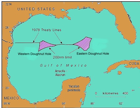
The Mexico-USA Transboundary Hydrocarbons Agreement (THA) has been approved by senators in Washington. The accord allows both countries to explore and develop crude reserves that straddle their exclusive economic zones in the Gulf of Mexico. It establishes “an environmentally safe and responsible framework to explore, develop, and share revenue from hydrocarbon resources that lie in waters beyond each country’s exclusive, economic zones,” according to White House National Security Council spokesperson Caitlin Hayden.

location of doughnut holes

The two “doughnut holes” where Mexican and US Exclusive Economic Zone claims overlap

The American Petroleum Institute has hailed the possibility of Mexico-USA joint projects in the Gulf of Mexico. The reserves in the maritime boundary region are believed to total more than 170 million barrels of oil and 15 million metric tons of natural gas, according to the U.S. Department of the Interior’s Bureau of Ocean Energy Management.

Related posts:


National Hurricane Agency and National Atlas of Risks

 Mexico's geography in the Press  Comments Off on National Hurricane Agency and National Atlas of Risks
Jan 232014
 

Speaking at an event to mark the 25th anniversary of the establishment of the National Water Commission (Conagua), President Enrique Peña Nieto announced that the government has allocated 170 million dollars towards modernizing the National Meteorological Service (Servicio Meteorológico Nacional, SMN).

The modernization will include establishing a National Hurricane Agency to coordinate hazard prediction, prevention and mitigation actions with state and municipal authorities to reduce the impacts of natural climatic hazard events.

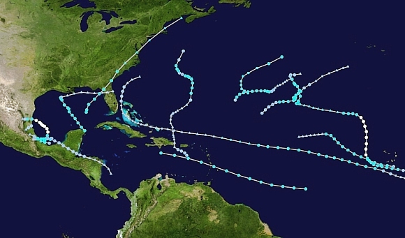
2013 Atlantic Hurricane Season

Ironically, the 2013 season (shown) was the first Atlantic hurricane season since 1994 to end with no major hurricanes.

In related news, the government has also announced that progress is being made in compiling a National Atlas of Risks. The Atlas is an interactive GIS database containing details of settlements, soils, rivers, dams, highways, rail lines, river basins, oil fields, and many other factors related to the assessment of vulnerability and risk. Due to be completed by 2016, it will help all three levels of government (municipal, state, federal) decide how best to allocate hazard mitigation resources and improve the accuracy of risk assessments utilized in future planning decisions.

Related posts:

Plans to improve the Mexico City-Toluca transport corridor

 Mexico's geography in the Press  Comments Off on Plans to improve the Mexico City-Toluca transport corridor
Jan 202014
 

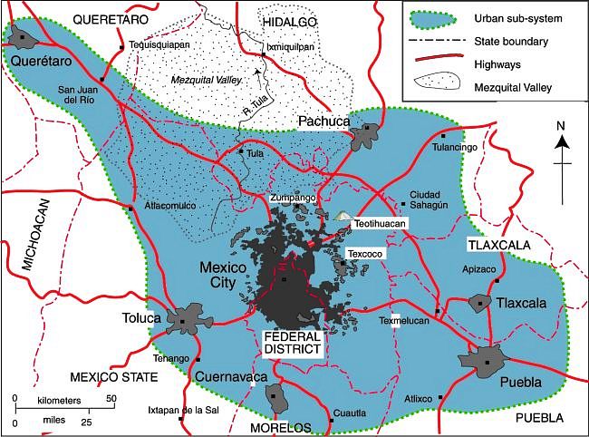
The Mexico City Metropolitan Area (dark grey on the map), which occupies the Valley of Mexico, extends well beyond the northern boundary of the Federal District and includes many municipalities in the State of Mexico. The two administrations (the Federal District and the State of Mexico) have to work closely together in order to coordinate actions in the Metropolitan Area, which had a population in 2010 of 20.1 million.

Map of Mexico City urban system

Map of Mexico City urban system. Click to enlarge. (Geo-Mexico Fig. 23.1; all rights reserved)

Toluca, the capital of the State of México, is Mexico’s 4th largest urban area, and a fast-growing industrial city in its own right, with a 2010 population of 1.8 million.

Toluca’s airport (the “Licenciado Adolfo López Mateos International Airport”) is mainly used by low-cost carriers like Interjet, Volaris and Aeroméxico Connect as an alternative to using the Mexico City International Airport, which is more expensive and operating at close to capacity. Passenger traffic through Toluca airport has grown rapidly, from 145,000 passengers in 2002 to a peak of almost 4 million in 2008, before falling back to about 1 million passengers in 2012.

Not surprisingly, the Mexico City-Toluca highway is one of Mexico’s busiest major routes, linking the Federal District via Toluca (see map) to western Mexico.

In recent months, several related plans have been announced that are designed to improve the two major transportation issues in this area:

  1. The near saturation of Mexico City International Airport
  2. The very busy (and often slow) highway between Mexico City and Toluca

To ease the situation of Mexico City International Airport, the federal Communications and Transportation Secretariat (SCT) plans to expand the airport eastwards, onto 5,500 hectares of federal land. The expansion is likely to take several years to complete, and will increase flight capacity even though it will not include an additional terminal.

Meanwhile, State of Mexico authorities have authorized a second runway for the Toluca International Airport, which will significantly expand that airport’s capacity. The SCT has proposed that Toluca Airport become an alternate airport for Mexico City, with the two airports linked by high-speed trains.

The SCT has already announced that a new rail link between Toluca and Mexico City will be jointly financed by the federal government and the State of Mexico. The existing plan is for the first phase of the “Toluca-Valley of Mexico Interurban Passenger Train” to end at the Metro Observatorio station in Mexico City, but a later phase would extend this line to Mexico City Airport. This new 2.7-billion-dollar rail line, capable of carrying 300,000 passengers a day, will run from Toluca via the upscale Mexico City neighborhood of Santa Fe to Metro Observatorio, reducing the travel time between Toluca and Metro Observatorio by more than an hour to around 40 minutes, with corresponding positive environmental impacts. Construction of the new line, which will include 4 intermediate stations, is due to begin later this year, and scheduled to be completed by 2018.

A separate 115-million-dollar project is underway to reduce highway congestion between Toluca and Mexico City. To boost the road transport capacity between the two cities, a multi-lane second tier is being added to 15 kilometers of the existing Mexico City-Toluca highway, from La Marquesa to Paseo Tollocan, at the entrance to Toluca.

Related posts:

Mexicali receives more deportees than any other Mexican border city

 Mexico's geography in the Press  Comments Off on Mexicali receives more deportees than any other Mexican border city
Jan 182014
 

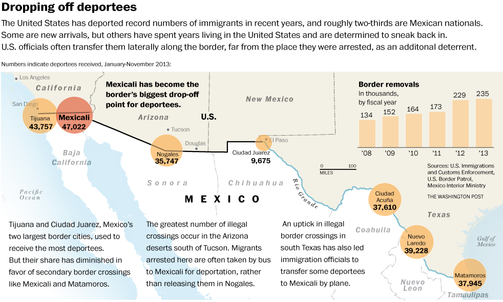
A recent Washington Post article – Mexicali has become Mexico’s city of the deported as U.S. dumps more people there – highlights the fact that Mexicali now has the dubious distinction of receiving more deportees from the USA than any other Mexican border city.

As the article points out, “Once, border cities like Mexicali (population 700,000) were flooded with newcomers trying to go north. Today, they are filling with obstinate deportees, cut off from U.S.-born children, jobs and car payments, adrift in a kind of stateless purgatory that is beyond the United States but not really in Mexico either. They face a U.S. border that is tougher and more expensive to cross than ever.”

The U.S. Immigration and Customs Enforcement (ICE) agency deported more than 400,000 migrants in the 2012 fiscal year, and close to 370,000 in 2013, about two-thirds of them to Mexico. Mexican government statistics for that time frame show that more than 110,000 were “repatriated” to Mexicali, even though it was not their point of origin, or even the closest Mexican border city to where they were detained.

According to the Mexican Ministry of Foreign Affairs (SRE) the deportees from the USA in 2012 included 13,454 unaccompanied Mexican minors under the age of 18.

This Washington Post graphic (click image to enlarge) neatly summarizes the situation.

Number of people deported to Mexico's border cities

Number of people deported to Mexico’s border cities. Click to enlarge. Credit: Washington Post.

The Washington Post article makes for some sober reflections on the plight of many of those deported from the USA, especially those individuals who have very strong family ties to that country.

The longer term social effects of such deportations are the focus of this article by Joanna Dreby, assistant professor of sociology at the University of Albany, State University of New York.

Related posts:

NAFTA 20 years on: success or failure?

 Mexico's geography in the Press  Comments Off on NAFTA 20 years on: success or failure?
Jan 092014
 

The North American Free Trade Association (NAFTA) came into effect on 1 January 1994. Twenty years on, opinions remain sharply divided over the extent to which NAFTA has benefited Mexico and Mexicans.

NAFTA has led to progress

The Economist magazine is among those arguing that NAFTA has transformed the Mexican economy for the better, but that much remains to be done if Mexico is to make the most of its partnership with the USA and Canada. Two recent articles from The Economist summarize the arguments for NAFTA having been a success story for Mexico:

NAFTA has hindered progress

Other analysts are equally convinced that NAFTA has hindered Mexico’s economic progress and has brought problems for many Mexicans. For example, Timothy A. Wise, the policy research director at Tufts University’s Global Development and Environment Institute, argues that NAFTA has had adverse impacts on agriculture and on Mexico’s food security.

In Wise’s view, NAFTA had a sequence of impacts. First, it led to a flood of US imports of corn, wheat, meat and other staples which drove Mexican producer prices down below the costs of production. (Some US corn exports to Mexico were “dumped” at prices 19% below even US farmers’ costs of production). While Mexico’s own agricultural exports to the USA increased due to NAFTA, the overall agricultural trade deficit between the two countries widened considerably, with Mexico needing to import almost half of its total food requirements by the mid-2000s.

The international prices for many of these imported crops have doubled or tripled over the past decade, and Mexico’s agricultural trade deficit with the USA jumped to more than $4 billion. Why does Wise choose to highlight the beer industry? He argues that even the success of Mexico’s beer industry has brought more benefits to US farmers than Mexican farmers because the two major raw materials for beer (barley and malt) are not produced in Mexico, but imported from the USA.

Similarly, in a Guardian article entitled NAFTA: 20 years of regret for Mexico, Mark Weisbrot, the co-director of the Centre for Economic and Policy Research in Washington DC, concludes that, “It’s tough to imagine Mexico doing worse without NAFTA.”

Conclusion

Both sides of this argument hold some merit. While some sectors of Mexico’s economy, and some people, have undoubtedly gained from NAFTA, others have lost.

Related posts:

Incarceration in Mexico: distance decay from California?

 Mexico's geography in the Press  Comments Off on Incarceration in Mexico: distance decay from California?
Jan 072014
 

In a previous post – 2013 Mexico Peace Index: Mexico becoming more peaceful –we reported the work of the Institute for Economics and Peace in devising its inaugural 2013 Mexico Peace Index (MPI).

The interactive online maps that form part of this report repay some exploring. In addition to allowing you to view the pattern for MPI on a state-by-state basis, they also allow you to see the pattern for each of the 7 main indicators:

  • Homicide (includes murder, infanticide and non-negligent manslaughter)
  • Violent crime (includes rape, robbery and aggravated assault)
  • Weapons crime (the proportion of crimes that involve a firearm)
  • Incarceration (the annual number of people per 100,000 people over the age of 18 sentenced to prison)
  • Police funding (proportion of the Federal District Public Security Contribution Fund)
  • Organized crime (includes extortion, kidnapping, and drug related crimes)
  • Justice efficiency (the ratio of sentenced homicides to total number of homicides)

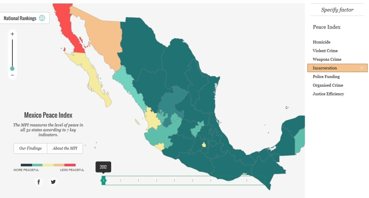
Looking at these maps recently, one curiosity that struck me was that the map for incarceration rates shows a clear distance-decay pattern (the kind of pattern we older geographers love to find, even if we can’t explain it!).

The map is a screenshot of incarceration rates in 2012. The incarceration rate is defined as the number of people /100,000 people over the age of 18 sentenced to prison in that year.

Incarceration rate in Mexico, 2012

Incarceration rate in Mexico, 2012. Credit: Mexican Peace Index. Institute for Economics & Peace

In this case (see map), it appears that the rate of incarceration varies with distance from the US state of California. The closer to California, the higher the incarceration rate. Looking more closely, it becomes apparent that the states along the northwest coast of Mexico, west of the Western Sierra Madre, have higher incarceration rates than those inland or further south. This means that a better description of the pattern might be that states that are closer in travel time, or ease of travel, to California have higher incarceration rates. This has the added attraction of bringing the eastern state of Quintana Roo into the picture given the large number of flights from Los Angeles to Cancún!

Even if a pattern exists, this kind of conjectural analysis is not the same as a causal explanation. In this case, surely it is just a coincidence that incarceration rates happened to arrange themselves like this? Perhaps the analysis of incarceration rates in future years will shed more light on this spatial curiosity!

For other examples of distance decay, see

The full 96-page 2013 Mexico Peace Index report – available here – is well worth reading and offers many more insights into the changes taking place in Mexico.

Related posts:

Update on Mexico and the UN Millennium Development Goals (MDGs)

 Mexico's geography in the Press  Comments Off on Update on Mexico and the UN Millennium Development Goals (MDGs)
Dec 302013
 

More than 190 countries signed up to the 2015 UN Millennium Development Goals (MDGs), agreed in 2000. There are 8 major goals:

  1. eradicate extreme poverty and hunger
  2. achieve universal primary education
  3. promote gender equality and empower women
  4. reduce child mortality
  5. improve maternal health
  6. combat HIV/AIDS, malaria and other diseases
  7. ensure environmental sustainability
  8. develop a global partnership for development

millenium-development-goalsMexico is well on its way to meeting most of the eight goals, according to the technical committee established to monitor the country’s progress. The technical committee includes representatives from various government departments, as well as INEGI (the National Geography and Statistics Institute) and CONAPO (the National Population Council).

The committee reports that Mexico has already met the targets for 38 (74.5%) of the 51 quantitative indicators used to assess progress towards the 8 goals, and is continuing work towards meeting the remaining targets by 2015 (the deadline for the Millennium Development Goals).

Satisfactory or good progress is being made on 5 of the remaining 13 indicators; all five are expected to be met sometime in 2015.  Progress on the other 8 indicators has been slower than needed, and it now seems highly unlikely that goal 7 (environmental sustainability) can possibly be met.

Specific targets that Mexico has not yet reached and where progress has either stagnated, or deterioration has occurred, include:

  • Decrease in mortality rate per 100,000 inhabitants due to HIV/AIDS  (part of goal 6)
  • Total carbon dioxide emissions (part of goal 7)
  • Proportion of total water resources already in use (part of goal 7)
  • Percentage of inhabitants with private dwellings using charcoal or wood for cooking (part of goal 7)

Related posts:

The city of León in Guanajuato uses Google Earth to monitor its water usage

 Mexico's geography in the Press  Comments Off on The city of León in Guanajuato uses Google Earth to monitor its water usage
Dec 212013
 

León, in the state of Guanajuato, is a prosperous industrial city (population 1.6 million), which built its wealth by processing animal hides obtained from the surrounding ranching areas into all manner of leather goods, especially clothing, accessories and shoes, the range of which goes from casual to ultra-fashionable. León does not just have shoe stores, it has shoe shopping centers!

Founded in 1576 and named for a province in Spain, the city became an important colonial center, well positioned on the main trading routes. It later became important for anti-colonial sentiment. Brothers Juan and Ignacio Aldama, born here in the eighteenth century, became key figures in the Independence movement led by Father Miguel Hidalgo. Shortly after Independence, the city’s shoe industry started, introduced by skilled craftsmen from Puebla.

Like any wealthy Mexican city, León has lots of old buildings, including the eighteenth century Cathedral with its fine choir stalls and the Nuestra Señora de los Angeles church, embellished by the interesting carvings of a native craftsman. The impressive Town Hall, with its elaborate façade, is a nineteenth century addition, as is the Manuel Doblado Theatre, designed by José Noriega who also had a hand in building theatres in several other cities in the region, including Guanajuato, Aguascalientes and San Luis Potosí.

leon-agua-monitoreoThe city would have even more old buildings today were it not for the disastrous flood of June 1888 when torrential downpours caused the Río Gómez to burst its banks. A wall of water and debris swept away more than 2000 homes, causing 200 fatalities and making 20,000 homeless. Major engineering works shortly afterwards have ensured that the city is now safe from future events of this kind.

The city has grown into one of Mexico’s most important industrial centers. The position of León has been key to its success. The city is located in central Mexico, close to the major urban areas of Mexico City, Querétaro and Guadalajara. On a broader scale, it is close to the major export markets of the USA, Canada and Central America. Market proximity is enhanced by an excellent communications network, including good road and rail links, easy access to several major airports, and to seaports such as Manzanillo.

Like most cities in central Mexico, one of León’s most pressing problems is how to ensure that its residents and industries have an adequate supply of potable water, even though the city was rated #1 in the country in terms of overall performance in this regard in the 2011 report “Water Management in Mexican Cities”.

In order to monitor the city’s water usage more effectively, engineers from the León Potable Water and Sewerage System (SAPAL) have introduced a sophisticated software system that provides real time data about the city’s water network and wells. It enables the engineers to overlay data like address, owner, account status, and water consumption onto a series of screen connected to Google Earth.

The system was developed in-house by local engineers, starting more than a decade ago, at a fraction of the cost of purchasing a similar system from an external provider. The León system is already being closely studied by water experts from other cities and countries.

SAPAL’s Control and Monitoring Center has a video wall, measuring 7.5 by 2 meters, with 24 LED screens. The center functions 24 hours a day, monitoring details of water distribution for more than 9000 data points, including wells, pipelines and holding tanks.

According to Agustín Báez, the city official responsible for SAPAL operations, the objective is “to have measurement from point of extraction to final use” since “what is not measured is not controlled.”

Sources:

Related posts:

Dec 162013
 

In October 2013, the protection status of the Nevado de Toluca, Mexico’s fourth highest peak, was downgraded from National Park to Wildlife Reserve (Area of Protection for Flora and Fauna).

On paper, this is a significant downgrade that may now open the door to greater economic activity in the former National Park area with adverse environmental consequences. In practice, it might turn out to be a blessing in disguise and herald the start of a more pragmatic approach to environmental protection.

Is this good news or bad? This post considers some of the possible implications of the volcano’s recent change of status.

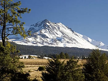
El Volcán Nevado de Toluca

El Volcán Nevado de Toluca

Background:

The Nevado de Toluca (also known as Chicnautécatl) is Mexico’s fourth highest peak, with a summit elevation of 4680 m (15,354 ft) above sea level. Located in central Mexico, southwest of the city of Toluca (the capital of the state of Mexico) and 80 km (50 miles) from Mexico City, the Nevado de Toluca is one of the most accessible volcanic peaks in the country. During the warmer months, regular vehicles can be driven very close to the volcano’s crater with its small lakes. During cooler months, when snow blankets the top portions of the mountain, the access road is popular with Mexico City families wanting to show their children what snow looks and feels like.

The area was granted National Park status in 1936, during the administration of President Lázaro Cárdenas, at a time when deforestation threatened to undermine the mountain’s ability to capture rainwater and be used as a water source for Mexico City and Toluca. (1936 was an important year in the history of environmental protection in Mexico because it was when the International Parks Commission was established which led to a series of protected areas–National Parks, Wildlife Areas and Forest Reserves–being established on either side of the Mexico-USA border).

The decree establishing the Nevado de Toluca National Park called for the expropriation of all the land around the volcano that was over 3000 m in elevation. The total area involved was about 536 sq. km. (207 square miles). While, for a variety of reasons, this expropriation was never fully implemented, deforestation of the volcano’s slopes was halted and tree-cutting banned.

In the succeeding decades, settlement expansion gradually ate away at the lower slopes with the result that the original National Park area now houses more than 5000 inhabitants in at least 16 distinct villages.

The newly designated Wildlife Reserve has a nucleus, centered on the crater, of 1.9 sq km, surrounded by a buffer zone of 51.7 sq. km.

A draft of the management plan for the Wildlife Reserve has been published by the National Commission for Protected Natural Areas (Comisión Nacional de Áreas Naturales Protegidas, CNANP) and made available for public consultation. The statuary 60-day consultation period began in mid-November.

The draft management plan [Map and plan both dated 5/11/2013] has met with considerable criticism in the popular press. The main issue is whether or not any such plan, however well intentioned, will be effectively enforced.

Several journalists have highlighted the very real danger that the new status will allow changes of land use in the former park that could lead to serious environmental degradation. The possible expansion of mineral extraction and of tourism within the Wildlife Reserve are of particular concern.

Nevado de Toluca Crater June 1986.

Nevado de Toluca Crater, June 1986. Photo: copyright Christopher Kessler (Wikimedia Commons)

Mining

In “Se tolerará la minería dentro del Nevado de Toluca“, Paris Martínez looks at the situation of several mining operations in the former park currently quarrying volcanic sand and gravel. Only one of these companies apparently had the requisite permit from the State of Mexico to quarry within the National Park area. The draft management plan allows all the quarries to continue operating for at least five years. Effectively, as Martínez points out, the change of status of the Nevado de Toluca means that mining operations that were operating illegally within the park are now “regularized”, for at least five years.

The main existing sand and gravel quarries are: El Atorón and Loma Alta in the municipality of Zinacantepec La Loba, El Capulín, Las Lágrimas (the only one with a state permit) and El Varal in Temascaltepec.

There are also reported to be many smaller illegal quarries extracting tepojal, a volcanic deposit similar to pumice, used in the construction industry. Unsupervised and unauthorized extraction is especially prevalent on the southern and eastern sides of the Wildlife Reserve.

Local residents say that quarrying, together with the construction of the access roads required to access the quarries, has resulted in serious environmental damage to the slopes of the volcano. Specifically, quarrying activities have led to:

  • deforestation
  • erosion, soil loss, degraded hydrology
  • loss of soil water absorbing capacity
  • particle emissions
  • loss of slope stability
  • visual pollution

The impacts of quarrying are not confined to the slopes of the volcano. The increased erosion of the lower slopes has led to local streams having to cope with a higher sediment load, reducing their capacity to carry the heavy rainy-season precipitation. This has led to flooding damage downstream in municipalities such as Tenango del Valle, Calimaya and Rayón.

The management plan appears to lack a clear pathway for the regulation or limitation of quarrying activities. At the same time, it calls for short-term remediation of areas that have been subject to soil degradation, but only for former mining areas that are not currently being exploited. It does nothing to reduce soil impacts in areas where quarrying is ongoing.

While the management plan does not discuss how or when the quarries might be closed, it does propose establishing workshops to develop “alternative productive activities” for the owners of small quarries, to provide them with an alternative source of income. However, the workshops are only mentioned as part of the long-term plan, ie to be introduced at some point at least 5 years down the road.

What’s more, only one alternative productive activity – public use, open-air recreation and tourism- is actually mentioned in the plan, alongside those activities that would provide products or services for tourism. Surely the final version of the plan should also suggest other viable options?

The plan calls for compensation for the owners of property where quarrying is halted, and who opt for alternative activities. However, this too is only mentioned as part of the longer term plan, so many landowners may well be tempted to start mining in the interim, in order to be able to claim compensation in a few years’ time!

Tourism

The decision to change the protection status of the Nevado de Toluca was based on a commissioned study that showed the area had potential for “intensive tourism” and “private infrastructure”. The study identified potential “tourism nuclei” or “sites for intensive tourism” where the construction of cabins was considered “feasible”. Following criticism and opposition that included almost 30,000 signatures on a change-org petition, the draft Management Plan does not use terms like “intensive tourism” and states that “tourism developments and ski runs may NOT be built in the area”, nor may subdivisions, hotels, golf courses or weekend homes.

The draft plan calls for “low-impact tourism” which is environmentally aware, defined as being suitable for activities such as hiking trails, camping and bird-watching. The plan allows for this form of tourism to be developed in most of the core area of the crater of the Nevado de Toluca as well as in a 3-square-kilometer section on the slopes of the volcano. The plan also allows existing settlements (whose area is not precisely defined) to develop tourism infrastructure; this could easily result in some short-term land-grabbing. Equally, precisely what counts as tourism infrastructure is not clearly defined.

Accepting that the National Park was never adequately patrolled or regulated, then if the new Wildlife Reserve Management Plan is tightly written and backed up by effective monitoring and the enforcement of regulations, then the volcano’s change of status may yet prove to be the best way to preserve the mountain’s unique character.

The draft plan is a valuable step forward, but Geo-Mexico hopes that the final Management Plan will address the many concerns raised in the press, to the benefit of both the volcano itself and its local residents.

Thanks to Arq. Ricardo Warman for first alerting us to the Nevado de Toluca’s change of protected status.

Related posts:

2013 Mexico Peace Index: Mexico becoming more peaceful

 Mexico's geography in the Press  Comments Off on 2013 Mexico Peace Index: Mexico becoming more peaceful
Dec 142013
 

The Institute for Economics and Peace (IEP), an independent, non-profit research organization dedicated to promoting a better understanding of the social and economic factors that develop a more peaceful society, has released its first Mexico Peace Index. The 2013 Mexico Peace Index (MPI) is based on a similar methodology as previous IEP indices, including the United States Peace Index and the United Kingdom Peace Index; however specific measures were included to better reflect the specific Mexican cultural and national context.

For the Mexico Peace Index, seven indicators were used to analyze peace: homicide rates, violent crime, weapons crime, incarceration, police funding, efficiency of the justice system, and the level of organized crime.

The study was performed with the guidance of an Expert Panel representing various institutions such as IMCO, CIDE, Mexico Evalua and INEGI. The Mexico Peace Index 2013 uses data provided by INEGI and the Executive Secretariat of the National Public Security System (SESNSP).

Mexico Peace Index

Mexico Peace Index. Credit: Institute for Economics and Peace.

The headlines

  • Mexico Peace Index finds that peace improved 7.4% in past two years
  • The two-year improvement in peace was primarily driven by a 30% decrease in organized crime
  • Most peaceful states experienced an annual GDP growth of more than double the least peaceful states
  • Oaxaca, Chiapas, and Yucatan have the most improved levels of peace in the past decade
  • Mexico has the greatest potential in the world to overcome its current levels of violence and build a more peaceful society, with a strong business environment and high levels of human capital
  • The eastern region of Mexico is the most peaceful; the northern region the least

The 2013 MPI provides a comprehensive assessment of peace in Mexico detailing the level of peace in each of the 32 states over the last 10 years and an analysis of the costs associated with violence as well as the socio-economic dimensions associated with peace.

mpi-coverThe study finds that there was a 7.4% improvement in Mexico’s peace scores in the last two years, driven by decreases in organized crime, violent crime, and weapons crime. However, over the past 10 years Mexico experienced a marked increase in direct violence, with peace declining by 27%. A key factor was the 37% increase in the homicide rate since 2007.

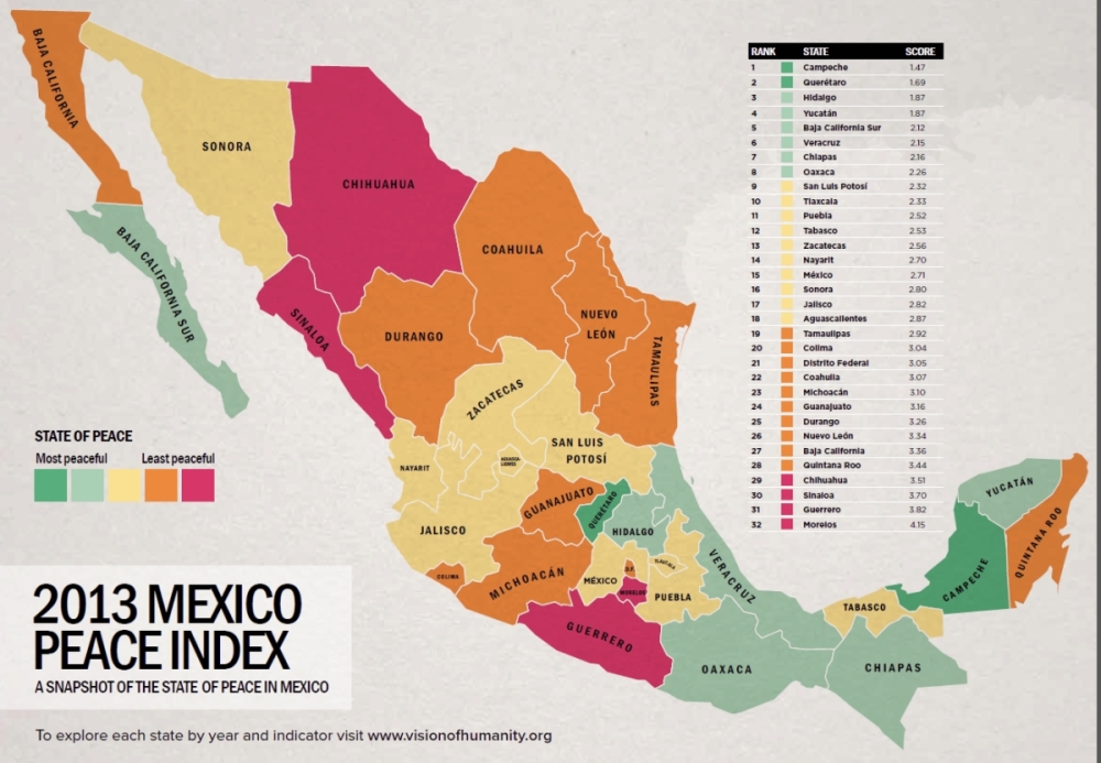
The 2013 MPI presents comparisons between the states and the regions of Mexico, and finds that the states with the highest levels of peace are: Campeche, Queretaro, Hidalgo, Yucatan and Baja California Sur while the five least peaceful states are: Morelos, Guerrero, Sinaloa, Chihuahua, and Quintana Roo.

The study finds that Oaxaca, Chiapas and Yucatan experienced the most substantial increases in their levels of peace during the last decade. Oaxaca improved its score by 22% and Chiapas by 17%.  These states were found to be relatively peaceful in comparison with other areas of Latin America and North America. Campeche, for example, has a level of peace comparable with the states of New Mexico and Delaware in the United States.

Regionally, the research finds that the eastern region of Mexico is the most peaceful, while the northern region is the most violent.

Analysis of federal funding to state police (Fondo de Aportaciones para la Seguridad Publica) finds that increases in police funding are related to crime reporting rates, with increased funding improving the public’s relationship with the police.

The direct cost of violence to the Mexican economy is 3.8% of GDP, while the indirect costs amount to 12% for a total 2.49 trillion pesos (15.8% of GDP). Under optimal conditions, if there was no violence in Mexico, the economy would have the potential to improve by up to 27%. This figure includes direct and indirect costs and the additional flow-on economic activity that would eventuate from new money being added to the economy. The study highlights that if all the states of Mexico were as peaceful as Campeche, the most peaceful state in the country, Mexico would reap an economic benefit of 2.26 trillion pesos.

The most peaceful Mexican states in 2003 experienced the strongest economic performance in 2012. Over the past 10 years, these states’ GDP increased by 9% versus 4% in the least peaceful states.

Steve Killelea, founder and executive chairman of IEP said: “Compared to other countries with a similar level of conflict and development, Mexico has the greatest potential to increase its peace on account of the strength of the structures, attitudes and institutions that sustain peace in the long term.” He added that: “This research aims to provide the evidence base and data for a broader policy debate about how to reduce violence in Mexico”.

Mexico’s standing in regards to positive peace is encouraging: the country has a strong business environment, performs well on measures of human development, and ranks better than world averages on education.

Factors impacting peace in Mexico

It is well known that the increase in the levels of violence in Mexico has been a consequence of the war against drug trafficking, but there are other key factors at play.

The number of firearms smuggled into Mexico increased substantially during the last decade, almost three times higher in the period 2010-2012 than between 1997 and 1999.

As a consequence, the weapons crime indicator, which measures the number of offenses involving the use of weapons, recorded a significant increase of 117% per 100,000 people during the last decade.

The measure of the efficiency of the justice system has recorded a significant deterioration. In some states up to 95% of homicides remain unpunished.

In addition, the public perception of corruption is very high and one of the greatest challenges facing Mexico.

Prison capacity is overstretched with a Mexico Evalua 2013 report stating that 52.4% of prisons in the country are over-crowded and house 74% of the prison population in Mexico.

There is a high level of unreported crime in Mexico. According to data from the National Survey of Victimization and Perception of Public Safety 2012 (ENVIPE), only 19% of theft, 10% of fraud and 10% of extortion cases are reported.

It is important to address all of these key challenges in order to reduce violence and realise the social and economic benefits of peace in Mexico.

This post is the text of a press release from the Institute for Economics and Peace. For more information about the report, visit http://visionofhumanity.org/#/page/news/812 and http://visionofhumanity.org/#/page/indexes/mexico-peace-index

The full 96-page report – available here – is well worth reading and offers many more insights into the changes taking place in Mexico.

Related posts:
Dec 122013
 

Today is 12 December, the feast day of Our Lady of Guadalupe, the beloved indigenous patron saint of Mexico and much of the Americas. This seems like a good excuse, if ever one was needed, to revisit the “Gender Gap” in Mexico. The gender gap assesses the “gap” between females and males for a number of variables, but should not be taken as reflecting the quality of life of females in different countries.  For example, the gender gap between women in Japan and Japanese men is very large, even though Japanese women enjoy a relatively high quality of life.

In “The Global Gender Gap Report 2013″, the World Economic Forum (WEF), based in Geneva, Switzerland, placed Mexico 68th of the 136 nations included in the study. Between them, the 136 nations house 93% of the world population. Mexico has risen 16 places in the rankings since 2012, meaning that the gender gap in Mexico is narrowing, even if there is still a long way to go to reach gender equality. (It is worth noting that Mexico has been climbing steadily up the rankings for several years, from #98 in 2009, to #91 in 201, #89 in 2011 and #84 in 2012).

Of the 136 countries studied for the 2013 report, Iceland had the smallest gender gap, for the 5th year running, followed by Finland, Norway and Sweden.

Among Latin American nations, Nicaragua had the smallest gender gap (placing 10th in the world), with Cuba, which has the highest female participation in government, coming in 15th and Brazil remaining 62nd. Other notable placings were Germany 14th, and South Africa 17th.

gender gap graph for Mexico

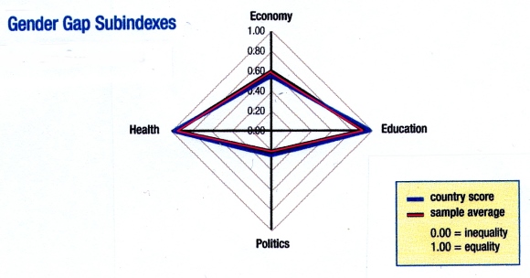
How Mexico (country score) compares to other countries (sample average). Source: Gender Gap Report 2013

The Gender Gap Index is a composite index comprised of a number of variables grouped into four key areas:

  • health and survival
  • educational attainment
  • political empowerment
  • economic participation

As noted in our summary of the 2012 Gender Gap Report, Mexico ranks #1 in the world, tying with several other countries, for the health and survival subindex. This means that Mexican females are unsurpassed with respect to sex ratio at birth (female/male) combined with female life expectancy (female/male).

For the other subindexes, in 2013 Mexico ranked #36 for political empowerment and #70 for educational attainment, but a lowly #111 for economic participation.

Geo-Mexico agrees wholeheartedly with Klaus Schwab, founder and executive chairman of the World Economic Forum, who called for renewed efforts to ensure gender equality, saying that, “Countries will need to start thinking of human capital very differently – including how they integrate women into leadership roles. This shift in mindset and practice is not a goal for the future, it is an imperative today.”

Related posts:

Mexico City explores deep water aquifer

 Mexico's geography in the Press, Updates to Geo-Mexico  Comments Off on Mexico City explores deep water aquifer
Dec 092013
 

Background: The Valley of Mexico is an interior basin about 9000 square km in area. The basin floor sits at an elevation of 2200 meters above sea level and is surrounded by mountains that rise up to more than 5000 meters above sea level. It receives around 700 mm of rainfall a year, with a rainy season from late May to September.

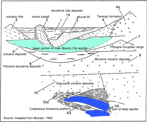
The basin was originally the site of several lakes and marshes, and much of it is underlain by lacustrine sediments up to 100 m thick, beneath which are alluvial sediments up to 500 m thick (see geological cross-section below). These sediments are interstratified with layers of volcanic basalt. Beneath the alluvial sediments are 100 m to 600 m of volcanic deposits, which form the principal Mexico City aquifer (found about 500 m to 1000 m below Mexico City).

As Mexico City has grown, and water demands have increased, this main aquifer has been greatly overexploited, leading to a drop in the level of the water table underground, accompanied by ground subsidence that has had serious consequences for Mexico City:

Feasibility study of a deep aquifer

The National Water Commission (CNA) and Mexico City Water System (SACM) are undertaking a 3-year, 23-million-dollar feasibility study to assess the potential of an aquifer that lies more than 2000 meters below Mexico City. (Our earlier, initial report about this aquifer is here).  The project includes experts from Pemex, CFE and UNAM’s Institute of Geophysics.

Schematic stratigraphy of the southern portion of the Basin of Mexico.

Schematic stratigraphy of the southern portion of the Basin of Mexico.
Source: Adapted from Mooser, 1990.

Initial exploratory wells have shown that the deep aquifer’s water quality is superior to that currently derived from the overexploited shallower wells that extend to depths of around 800m.

It is hoped that the feasibility study will confirm that water from the deep aquifer could be an additional viable source of freshwater for the city. Assuming the deep aquifer is hydrologically independent of the shallower aquifers, this  would not only reduce the need to pump water from the shallower aquifers, but would also avoid the ground subsidence resulting from continued shallow-water extraction. The feasibility study will assess whether or not the deep water aquifer is “fossil” water or is still being recharged from precipitation and underground throughflow. If it is being recharged, the experts will calculate its recharge rate to determine the aquifer’s maximum sustainable yield. (The maximum sustainable yield is the “additional groundwater output from the system which will cause minimal and acceptable levels of stress to the ecosystem with maximum benefits to the society and to the economy”).

The first test well is likely to be sunk in the Magdalena Mixhuca Sports City area, in the eastern part of Mexico City.

This potential deep aquifer source of freshwater could play a vital part in ensuring that future generations of Mexico City residents have a dependable and sustainable water supply.

Mexico’s consideration of utilizing deep water aquifers runs counter to the prevailing wisdom in the US where it has long been argued that deep water aquifers will be too costly to utilize for fresh water, will never be used, and are therefore more useful as a repository for waste and can be intentionally polluted.

As a result, as this Huffington Post article explains, “policy-makers often exempt these deep aquifers from clean water protections and allow energy and mining companies to inject pollutants directly into them.”  The article adds that, “the U.S. Environmental Protection Agency has issued more than 1,500 permits for companies to pollute such aquifers in some of the driest regions. Frequently, the reason was that the water lies too deep to be worth protecting.”

References:

Mooser, F. 1990. “Estratigrafía y estructura del Valle de México en el subseulo de la cuenca del Valle de México y su relacíon con la Ingeniería de cimentaciones, a cinco anos del sismo”, in Revista de la Sociedad Mexicana de Mecánica de Suelos. Mexico, D.F.

For a detailed description of Mexico City’s shallower aquifer and its exploitation, see Mexico City’s Water Supply: Improving the Outlook for Sustainability (1995) (viewable online or register for a free download)

Related posts:

Dec 052013
 

After studying 22 countries with sizable retirement communities, International Living (a consultancy group) rated Mexico as the fourth most attractive country for foreigners to retire to in 2013, after Ecuador, Panama and Malaysia. The study looked at eight factors: real estate, benefits for retired people, cost of living, integration, entertainment, health, infrastructure and climate.

According to the US Census Bureau, there are 41 million people of retirement age in the USA. More than half of them have annual incomes of between 70,000 and 150,000 dollars, and they are expected, on average, to live to the age of 83; 80% are home owners. This number will swell to 72.8 million by 2030, 40% of whom may have difficulties maintaining their previous lifestyles during retirement. Given its proximity, this makes Mexico an attractive destination for many baby-boomers seeking a comfortable retirement lifestyle.

But where in Mexico will these retirees choose to live?

According to this analysis by the consultancy Aregional, there are 36 specific areas in Mexico where the real estate market is targeting US baby boomers seeking a place to retire. About half of these locations (see map) are in central and western Mexico. Locations in these regions include Guanajuato and San Miguel de Allende (both in the state of Guanajuato), Colima, Comala and Manzanillo (Colima); Chapala, Ajijic and Puerto Vallarta (Jalisco); and Nuevo Vallarta and Punta Mita (Nayarit).

Locations of retiree real estate developments. Credit: Aregional

Locations of retiree real estate developments. Credit: Aregional

Locations in northern Mexico important for retiree real estate include Rosarito, Ensenada and Los Algodones (Baja California); Los Cabos, La Paz and Loreto (Baja California Sur); Puerto Peñasco (Sonora) and Mazatlán (Sinaloa). [Kudos to RickS for noticing that Puerto Peñasco is not located very accurately!]

Retiree real estate is also prominent in several places in the south and south-east of Mexico, including  Acapulco and Punta Ixtapa (Guerrero); Huatulco (Oaxaca); Playa del Carmen and Cancún  (Quintana Roo); Puerto Progreso (Yucatán), as well as the cities of Campeche and Veracruz.

It is not known how many US retirees have already chosen to live in Mexico. While it is relatively easy to quantify the number of retiree tourists (those staying more than one night, but less than six months), it is impossible to accurately quantify the number of non-working, non-Mexicans who have chosen to relocate full-time to Mexico. Technically, these “residential tourists” are not really tourists at all but longer-term migrants holding residency visas.

Residential tourists already form a very distinct group in several Mexican towns and cities, with lifestyle needs and spending patterns that are very different from those of regular tourists. Their additional economic impact is believed to exceed $500 million a year.

A case study of residential tourism, and its pros and cons, in Chapala-Ajijic on the northern shore of Lake Chapala is an integral part of chapter 19 of Geo-Mexico: the geography and dynamics of modern Mexico.

Posts related to retirees in Mexico:

Survey in March 2013 identifies crime as Mexico’s biggest public concern

 Mexico's geography in the Press  Comments Off on Survey in March 2013 identifies crime as Mexico’s biggest public concern
Oct 262013
 

The Pew Research Global Attitudes Project (released 24 October 2013) provides results of face to face interviews with a national sample of 1,000 adult Mexicans. The report revealed opinions concerning a wide variety of issues including the country’s direction, most important concerns, law and order, drug war, national institutions and attitudes toward the USA. Mexicans are generally dissatisfied with their country. In March 2013, 69% of Mexicans said they were dissatisfied, up from 63% in 2012, but down from 79% in 2010. The survey suggests that crime is a major cause for dissatisfaction.

The biggest concern identified in the survey is crime which 81% said was a very big problem, up from 73% in 2012. Several other crime-related issues topped the very big problem list: cartel-related violence (71%), illegal drugs (70%), human rights violations by the military and police (70%) and corrupt political leaders (69%). The concern for crime causes real fear. The survey noted that 63% say they are afraid to walk alone at night within one kilometer of their home, up 7% from 2012 and 13% from 2007. Women were only slightly more concerned about their safety than men (65% versus 60%). Those in urban areas were significantly more worried about safety than those in rural areas (70% versus 43%). On the other hand, the fact that over four in ten in rural areas were worried is both surprising and startling.

Unfortunately, we do not have a complete regional breakdown of the survey respondents. We speculate that crime is perceived as a bigger problem in high crime areas such as the north. Attitudes toward bribery appear to support this view. While 32% said they had to pay a bribe to a government official in the past year; the percentages ranged from 51% in the north to 18% in the Mexico City Region.

Over two-thirds (68%) felt that government should focus on maintaining law and order rather than protecting human rights (18%). Only 11% said that both were equally important. It is interesting that respondents from all three major political parties gave almost equal high priority to law and order: Party of the Democratic Revolution (PDR) – 66%; National Action Party (PAN) – 69% and Institutional Revolutionary Party (PRI) – 70%.

The drug war continues to be a problem; only 37% think the government is making progress, compared to 47% in 2012. Fully 29% said the government is losing ground in the drug war and 30% think it is about the same as it has been in the past. Over half (56%) blame both Mexico and the USA for drug violence. Only 20% blame just the USA, while 17% blame just Mexico. The vast majority (85%) want the Mexican army to fight drug cartels and over half (55%) would like the US government to provide weapons and training to fight the drug war. Only 34% would like to have US troops in Mexico fighting the cartels.

Given that the drug war is not going well and the military is implicated in many human rights violations, it is surprising that 72% of survey respondents feel that the military has a good influence on Mexico. This was higher than any other institution. About 68% felt the national government has a good influence. Other institutions got lower scores: the media – 66%, President Peña Nieto – 57%, Congress – 45%, court system – 44%, and police – 42%.

Aside from crime and related issues, Mexicans identified several other major problems. About five in eight (63%) considered poor quality schools a very big problem, way up from 49% in 2012. This increase was probably related to the arrest of the teachers’ union president and focus on the dire need for education reform. Other very big problems were pollution (60%), terrorism (59%) and people leaving Mexico for jobs (53%). This last item is a bit surprising since in recent years (since the Great Recession) relatively few Mexicans have left in search of jobs.

The percentage viewing the USA favorably has changed considerably in recent years. In early 2010, before passage of Arizona’s restrictive immigration law, 66% viewed the USA favorably. After passage of the law, this dropped to 44%, compared to an unfavorable view of 48%, up from 27% before the law. Clearly passage of that law had a very big impact on Mexicans. However the favorable ratings increased to 52% in 2011, 56% in 2012 and 66% in 2013. Meanwhile the unfavorable ratings dropped to 41% in 2011, 34% in 2012 and 30% in 2013.

Only 17% said they had traveled to the USA, but 21% indicated their families received money from relatives north of the border. About 47% indicated that moving to the USA leads to a better life, while 18% say it leads to a worse life. However, 44% say having citizens living in the USA is bad for Mexico, an equal number say it is good for Mexico. Apparently, the view is that it is good for individuals to move to the USA, but such moves may not necessarily be good for Mexico as a whole. Consistent with this, 35% said they would move to the USA if they had the means and opportunity, 20% would migrate without authorization while 15% would only migrate if they had authorization.

It will be interesting to see how these opinions change when the 2014 survey is conducted.

Related posts:

San Miguel de Allende: the “world’s best city”?

 Mexico's geography in the Press  Comments Off on San Miguel de Allende: the “world’s best city”?
Oct 212013
 

San Miguel de Allende has been selected as the “World’s Best City”, in the  Condé Nast Traveler‘s 26th annual Readers’ Choice Awards, announced 16 October 2013. (See also, The world’s best city is… by Frances Cha, CNN)

While being declared “the world’s best city” is an honor for San Miguel, and will no doubt increase tourism, it should be noted that it is merely a popularity contest among people visiting a website. Visitors to the website are given a list of candidates in each category and asked to rate them as excellent, very good, good, fair and poor. Within each category, voters rate individual criteria. For example, for resorts, visitors assess food/dining, location, overall design, rooms, and service. The percentage of excellent and very good ratings is used to compile the “best” lists.

smdcover

San Miguel de Allende (one of Mexico’s 31 UNESCO World Heritage sites) is noted for its well preserved colonial center, as well as for its atmosphere, culture, artist community and shopping opportunities. It beat out Budapest and Florence which tied for second. Salzburg placed 4th while last year’s winner, Charleston, South Carolina, was tied for 5th with San Sebastian, Spain. Other North American cities in the top 25 were Quebec City (10th), Vancouver, BC (13th) and Victoria, BC with Santa Fe, NM which tied for 17th. Four of the top 25 cities were in Italy: Florence (2nd), Rome (8th),  Sienna (9th) and Venice (24th).

The top five cities in Mexico, according to the Readers of Condé Nast Traveler, were:

  1. San Miguel de Allende
  2. San Cristobal de las Casas
  3. Guanajuato
  4. Morelia and Puebla – tied

However, the only Mexican cities on the questionnaire were: Acapulco, Cancún, Ciudad Juárez, Cuernavaca, Guadalajara, Guanajuato, Mérida, Mexico City, Monterrey, Morelia, Oaxaca, Puebla, Puerto Vallarta, San Cristobal de las Casas, San Miguel de Allende, Tijuana, Veracruz and Zacatecas. Each of these cities was rated with respect to cultural/sites, friendliness, atmosphere/ambiance, restaurants, lodging, and shopping. Obviously, many other Mexican cities, such as Mazatlán, are far from happy at being excluded from the list of candidate cities.

Other Condé Nast Traveler reader’s selections for Mexico included “top 15 hotels in Mexico”, “top 10 resorts in the Pacific Riviera, Mexico”, “top 10 resorts in Baja, Mexico”, and “top 30 resorts in Cancun and the Yucatan, Mexico”.

Clearly, hotels and resorts that are not included in the Condé Nast candidate list for this popularity contest miss out on a great deal of free publicity.

Related posts:

Mexico battered by massive storms from both east and west (September 2013)

 Mexico's geography in the Press  Comments Off on Mexico battered by massive storms from both east and west (September 2013)
Oct 192013
 

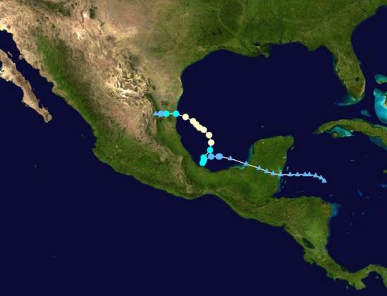
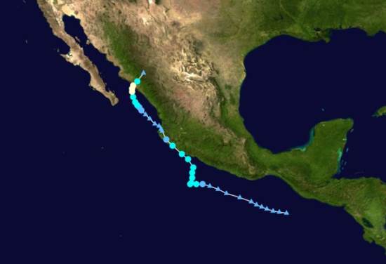
For the first time since 1958 Mexico was bashed virtually simultaneously by two very destructive storms: Ingrid in the east and Manuel in the west. Before discussing their destructive impact, we will describe the tracks of the two storms (photos below) and chart their chronology.

Track of Hurricane Ingrid

Track of Hurricane Ingrid

On September 10, weak weather disturbances were observed in the Caribbean east of the Yucatan Peninsula and in the Pacific south of Chiapas. The disturbance in the Caribbean gained some strength before hitting land which weakened it. It survived its crossing of the peninsula and re-emerged in warm waters of the southern Gulf of Mexico where it quickly gained strength. By the afternoon of September 12th it was upgraded to an official tropical depression.

Track of Hurricane Manuel

Track of Hurricane Manuel

Meanwhile the disturbance in Pacific moved slowly westward and by the morning of 13th was upgraded to a tropical depression. At about noon of the 13th both storms were upgraded to become named tropical storms (Ingrid and Manuel respectively) meaning they had winds of over 40 mph. In other words, the birth of “Ingrid” and “Manuel” were almost simultaneous (light green spots on the tracking maps). After earlier moving westward, both storms started to move north and slightly east picking up moisture, strength and wind speed over the warm ocean water.

Ingrid continued to move north gaining strength and by the next afternoon, the 14th, it was upgraded to a Category I hurricane with winds of 75mph. It started to move west and winds increased to 85mph on the morning of the 15th. Meanwhile Manuel also started to move west again skirting the coast of Guerrero and Michoacán. Early on the 15th Manuel’s winds reached 70mph. Though wind speeds did not quite reach hurricane level at that time and the eye of Manuel never made landfall, it brought enormous amounts of rain to coastal communities. For example, on September 14th Chilpancingo, Guerrero’s capital, got 393mm (15.5”) of rain while Acapulco got 140mm (5.5”) (Wunderground.com). This, added to considerable rain on preceding and following days, led to horrific flooding.

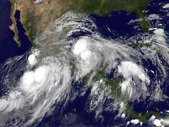
Satellite image of Hurricane Ingrid and Hurricane Manuel, September 2013

Satellite image of Hurricane Ingrid and Hurricane Manuel, 15 September 2013

On September 15th Hurricane Ingrid with winds of 75-85mph drifted toward Taumalipas in northeast Mexico. Meanwhile. Tropical Storm Manuel with winds about 60mph made landfall near Manzanillo, Colima. Once over land, the storm quickly lost power; by that evening winds were down to 35mph and Manuel was downgraded to tropical depression, but heavy rainfall continued. The next morning on the 16th Manuel’s winds were down to 30mph and it was further downgraded to a “remnant” of a tropical storm. But later that day, the remnant of Manuel move back to the Pacific Ocean near Puerto Vallarta and began to regain its strength.

That same morning September 16th Ingrid, which had weaken to a tropical storm with winds of 65mph made landfall just east of Ciudad Victoria, Tamaulipas. By the next morning, the 17th, Ingrid’s winds were down to 25mph and it was downgraded to a “remnant” though heavy rainfall continued.

Later on the 17th, Manuel regained its status as a tropical depression (winds of 35mph). The next morning, the 18th, it regained tropical storm status and by that afternoon it became Hurricane Manuel with winds of 75mph. Early on the 19th it made landfall west of Culiacan, Sinaloa. Moving east over land Manuel quickly lost power and was down to a remnant by the morning of the 20th. However, the remnant of Manuel continued far north and east joining the remnant of Ingrid and bringing torrential rains and flooding to central Texas, including Austin.

While storms are classified by their wind speeds from tropical depressions to tropical storms and then to hurricanes with intensities one up to five; this classification does not capture the extent of damage that can be caused. The amount of rain combined with the terrain can be far more damaging than the wind speeds. Furthermore the storm surge associated with a storm’s low pressure and high tides can be far more devastating than the winds as we saw with Hurricane Rita in New Orleans and Hurricane Sandy in New York.

In the case of Manuel, the amount of rainfall was far more destructive than the winds. The rains of Manuel as a “tropical storm” off the coast of Guerrero did far more damage than Hurricane Manuel did later in the State of Sinaloa or Ingrid did in eastern Mexico. Manual caused a total of about 84 reported deaths. At least 72 people were reported dead in Guerrero and another 68 were reported missing in the town of La Pintada that was partially buried under a massive mudslide. In Acapulco about 18 died. Floods closed the exit highways and the airport, temporarily stranding 40,000 tourists. These photos from the Guardian and USAToday show the extent of flooding in Guerrero, especially around Acapulco.

In contrast fewer than a dozen people reportedly died in Sinaloa which was later directly hit by Hurricane Manual. While Ingrid had considerably stronger winds than Manuel, its death toll of only about 23 was spread across several states from Puebla just east of Mexico City up to Tamualipas on the Texas border. More than half the total, 12 died in Altotonga, Veracruz, when a mudslide smashed into a bus. Of course, deaths are not the only, nor the best, measure of a storm’s destructive impact. Other commonly used measures are the financial cost of the damage and the number of people who evacuated or become homeless. No matter what measure is used, hurricanes are one of the most destructive natural hazards.

Related posts:

Plan for open-pit gold mine in Baja California Sur rejected

 Books and resources, Mexico's geography in the Press  Comments Off on Plan for open-pit gold mine in Baja California Sur rejected
Oct 122013
 

In November 2012, the federal Environment and Natural Resources Secretariat (Secretaría de Medio Ambiente y Recursos Naturales, Semarnat) refused a request to allow open-pit (opencast) mining in the buffer zone of the Sierra La Laguna Biosphere Reserve in Baja California Sur.

The request came from Zapal SA de CV, whose mining project, currently named “Los Cardones”, is located about 60 km from La Paz, the state capital. The proejct is close to the small settlements of El Triunfo, San Antonio and El Rosario. This mining project was previously called “Paredones Amarillos” and “La Concordia”. The original Concordia project, proposed by US mining firm Vista Gold and Toronto-listed Argonaut, was opposed on environmental and public health grounds by several environmental groups including the Mexican Center for Environmental Law (CEMDA).

Location of Los Cardones mining project. Credit: Tony Burton/Geo-Mexico

Location of Los Cardones mining project.

The latest version, Los Cardones, was resubmitted to authorities in September 2012. The project involved 423 hectares of semi-arid scrub-land, from which Zapal hoped to extract 40 metric tons of gold in the next decade using open-cast (pit) mining. The $217-million project would have created around 2200 jobs.

According to the project’s website (no longer functional), the mining project would have relied entirely on desalinated seawater (brought to the site by a 40-km aqueduct), which would be continuously recycled, and would therefore have no impact on local aquifers. Zapal claimed that the mine would have been the first gold mine in Mexico to use a closed-system cyanidation process, designed to prevent any contamination of the local environment. Zapal is part of the Invecture group which already operates an open cast copper mine in Piedras Verdes, Sonora, claimed to have an impeccable environmental and safety record.

Semarnat rejected the proposal on the grounds that it did not meet the legal requirements for mining operations in a Biosphere Reserve buffer zone. It is likely that a revised application will be made in due course. However, officials of the Baja California state government have previously gone on record as saying that they will oppose any open-cast mining in the state, because of its potential environmental impacts.

Anti-mining protests elsewhere in Mexico

David Bacon, author of “The Right to Stay Home: How US Policy Drives Mexican Migration”, wrote an informed account for the American Program website of several cases across Mexico where opposition to Canadian mining firms has arisen.

  • Mexican Farmers Up Against Canadian Mining Goliaths

A Guardian photo essay entitled “Mexico mining: ‘When injustice is law, resistance is duty’ – in pictures” reported on a January 2013 meeting of some 500 activists from across Mexico and Central America in Capulálpam de Méndez, Oaxaca. The meeting’s slogan was,  “Si la vida! No la
minera!” (Yes to life! No to mining!). It was held to co-ordinate local resistance to the human and environmental costs of mining on the region’s communities.

Related posts:

Goldcorp’s Los Filos mine in Guerrero: mega-mine or mega-disaster?

 Mexico's geography in the Press  Comments Off on Goldcorp’s Los Filos mine in Guerrero: mega-mine or mega-disaster?
Sep 282013
 

Canadian firm Goldcorp is the largest gold miner in Mexico, with mining concessions covering more than 40,000 hectares. Since 2008, it has been actively developing the mine of Los Filos, in the municipality of Eduardo Neri, which could become Latin America’s largest gold mine.

Los Filos is in Guerrero’s “Gold Belt” that runs from Mezcala to Argelia. The open-cast mine at Los Filos is midway between Mezcala and El Carrizalillo, some 50 km from the state capital Chilpancingo. The mining project will employ 800 workers and double the population of El Carrizalillo. The rocks here contain between 0.5 and 0.8 grams of gold per ton of ore. Los Filos is expected to yield 60 million metric tons of gold ore over the next 20 years, as well as some ancillary silver, lead and zinc. The mining operation will require investments of $1 billion over the mine’s anticipated 20-30 year lifetime.

Los Filos mine, Guerrero. Credit: Goldcorp

Los Filos mine, Guerrero. Credit: Goldcorp

The Los Filos project is actively opposed by several environmental groups, including The Mexican Network of People Affected by Mining (La Red Mexicana de Afectados por la Minería, REMA), a network of communities, movements, organization, groups and individuals “affected by, and concerned about, the socio-economic impacts of mining in Mexico”.

REMA has joined the campaign to force Canadian mining firm Goldcorp to halt work at Los Filos. REMA supports the recently created  Mesoamerican Movement Against the Extractive Mining Model, which claims that the existing extractive mining model has proven to be “highly predatory”, and has “significantly increased extraction, causing destruction of territory, seriously affecting natural resources, and irreversibly damaging the health of Mexican citizens”. It is especially concerned that hundreds of tons of cyanide have already been used in Mexico to process gold ore, contaminating water reserves.

REMA cites Goldcorp’s “Los Filos” mining project in Guerrero as a point of particular concern and an example of what is happening throughout the country. REMA claims that there is inadequate regulation and environmental monitoring and that the project is “causing division of communities, disease and death from the chemicals used and environmental damage through drainage of acids and polluting dusts”.

Another Goldcorp mining proposal, at Alto Lucero in the state of Veracruz, also met with substantial opposition from local residents and environmental groups. More information about the amounts of cyanide believed to be used in mines throughout Latin America, including Goldcorp projects, was available via a Map of Cyanide in Latin America (Mapa del Cianuro en América Latina) at http://www.conflictosmineros.net/biblioteca/campana-contra-el-uso-de-cianuro/mapa-del-cianuro-en-america-latina/download [Sep 2013]

Will Los Filos turn out to be a mega-mine or a mega-disaster? Only time will tell.

Related posts:

Sep 192013
 

An innovative aerial public transport system is being proposed in Mexico City as a way to help reduce traffic congestion and increase personal mobility. TUEP (Transporte Urbano Elevado Personalizado), a Mexican start-up, is being supported by the Federal District’s Secretariat for Science, Technology and Innovation (Seciti) and has manufacturing support from vehicle manufacturer DINA.

TUEP says that its system of aerial cabins offers more flexibility than cable cars and will save energy costs and take some vehicles off the roads, reducing emissions. It proposes a series of routes, each 5 to 10 kilometers long, linking densely populated residential areas to the city’s existing Metro and Metrobús networks.

The proposed system is fully automated. The aerial cabins, each seating two adults or an adult with two children, travel along a steel cable and can be diverted on and off the main route into a series of “docking stations” for passengers to alight or disembark. Each cabin is individually controlled by its passengers who select their destination using push button controls. This 2-minute Spanish-language Youtube news clip shows how the system works:

Each 5-kilometer stretch would be able to transport up to 5,700 passengers an hour at full capacity, at an average velocity of 4 m/s (14.4 km/hr). Cabins would travel about 10 meters (30 feet) apart, which should mean short wait times for passengers, who would pay about 6 pesos (less than 50 cents US) per trip.

Constructing the system will require posts placed every 50 meters along the route, with docking stations every 1000 meters or so. The system is being designed to be installed along avenues that currently have a median divide, so that there is minimum disruption to alternative forms of transport. According to its proponents, building TUEP lines would be at least 40% cheaper than adding additional Metrobús routes and only a fraction of the cost of expanding the city’s Metro system.

More details and images of the proposed system are offered in this 4-minute silent video:

TUEP has suggested 18 routes that are worthy of feasibility studies, which include Marina Nacional, Río San Joaquín, Taxqueña-Miguel Ángel de Quevedo, Lázaro Cárdenas, Constituyentes-Santa Fe and Eje 10. If all the proposed routes were built, the TUEP network would have a total length of 135 kilometers, and would have the capacity to handle up to 37 million trips a year.

Related posts:

Shopping habits in Mexico

 Mexico's geography in the Press  Comments Off on Shopping habits in Mexico
Aug 282013
 

Kantar Worldpanel México’s survey of shopping habits for 8,500 homes across the country reveals that 70% of household expenditures are spent in one of three main “purchasing channels”.

1. The first, traditional convenience or “corner” stores receive 35% of household spending, and are the channel most frequently visited, 217 times/year/household on average. Poorer households rely more on these stores than middle-class households. Most visits (71%) are on weekdays and 44% of visits are to purchase items for immediate consumption.

2. Supermarkets are the second main channel, used by 98% of households, with a frequency of 49 trips/year. Supermarkets are favored by middle class families for their weekly or biweekly shop, usually on weekends.

3. The third main channel is door-to-door and catalog sales, used by 92% of households, with a frequency of 42 times/year.

According to the study, 74% of households choose the nearest store and 78% attach importance to the location of the store.

Cities with Oxxo Distribution Centers. Credit: Tony Burton/Geo-Mexico

Cities with Oxxo Distribution Centers. Credit: Tony Burton/Geo-Mexico

It is no coincidence, then, that Oxxo, the nation’s largest convenience store chain, recently opened its 11,000th store in Mexico. Oxxo now serves residents of 350 towns and cities, and plans to add a further 1,037 outlets before the end of this year. Its extensive network is served via a chain of 15 strategically-located distribution centers in the 13 cities shown on the map above.

Related posts:

The pattern of homicides in Mexico in 2012

 Mexico's geography in the Press  Comments Off on The pattern of homicides in Mexico in 2012
Aug 172013
 

Homicide rates in Mexico increased between 2010 and 2012, though there is some evidence that they are now beginning to fall again. Did the pattern of homicide rates also change since 2010?

The top map shows the pattern of intentional homicides in Mexico in 2010. As we commented at the time, this map shows “that many northern states like Chihuahua, Sinaloa, Nuevo León and Durango are plagued by drug war violence and have very high murder rates. On the other hand, most states in the south and southeast, like Yucatán, Campeche and Tlaxcala are relatively free of drug war violence and historically have had low murder rates. One significant anomaly in the overall pattern appears to be Guerrero which is well to the south but has a high murder rate and a very significant amount of drug violence.”

Map of intentional homicide rate, 2010

Map of intentional homicide (murder) rate, 2010 Credit: Tony Burton / Geo-Mexico

The second map shows the pattern of intentional homicides in Mexico in 2012. (Note that the values on the key are slightly different to reflect the increase in Mexico’s average (nationwide) homicide rate between 2010 and 2012).

Map of homicide rates in Mexico, 2012, Credit: Tony Burton/ Geo-Mexico

Map of intentional homicide (murder) rates in Mexico. Credit: Tony Burton/ Geo-Mexico

At first sight the pattern in 2012 look pretty similar to that for 2010. The adjoining states of Sinaloa, Chihuahua and Durango continue to have rates well above the national average, as does Guerrero further south. However, the homicide rate in Nuevo León, which was “well above average” in 2010 has declined somewhat to “above average” in 2012. Since 2010, the north-eastern state of Tamaulipas has seen its homicide rate increase from “above average” to “well above average”. Perhaps more significantly, the border state of Coahuila has witnessed a jump from “below average” to “well above average”. Homicide rates in the two north-west border states of Baja California and Sonora have fallen since 2010 to “below average”.

Elsewhere, homicide rates have increased in both Zacatecas and in Colima since 2010, while rates in Veracruz have declined to “below average”. The shift in Veracruz means that a broad swathe of southern Mexico, including the Yucatán Peninsula, Oaxaca and Chiapas, now has a homicide rate “below average” or “well below average”, good news for tourists headed for Oaxaca, Cancún and the Riviera Maya!

On a more cautionary note, the state of Michoacán has seen increased violence in 2013; its homicide rate is headed upwards.

The changes in pattern of homicides between 2010 and 2012 are partially attributable to the “zones of contention” between rival drug gangs. For instance, the Knights Templar cartel (currently thought to be Mexico’s third largest cartel, behind the Zetas and the Sinaloa cartel) has its origin in  Michoacán but has expanded its geographic influence very rapidly in the past few years. Equally, the capture of key cartel leaders in recent years seems to herald increased violence as rivals compete to fill the perceived power vacuum left behind. This unfortunate outcome from the arrest of leading cartel operatives is continuing this year following the capture of Zeta leader Z-40.

Related posts:

Has the homicide rate in Mexico begun to fall?

 Mexico's geography in the Press, Updates to Geo-Mexico  Comments Off on Has the homicide rate in Mexico begun to fall?
Aug 102013
 

The National Statistics Institute (INEGI) recently published state-by-state intentional homicide (murder) statistics for 2012. The values calculated by INEGI for rates/100,000 population rely on CONAPO’s estimates for the population each year. The INEGI report includes homicide trends from 1990 to 2012.

From 1992 to about 2007, homicide rates in Mexico declined (see graphic) to 8/100,000 in 2007. However, during former President Felipe Calderón’s “War on Drugs”, the homicide rate almost tripled. In 2010 and 2011, the national rate averaged 23/100,0000. These national averages mask a huge difference between males and females. For example, the 2011 rate for males was 43/100,000, about eight times higher than the 5/100,000 recorded for females. As the graphic shows, there is some slight evidence that the homicide rate for males is beginning to fall again.

Trends in homicide rate, 1990-2012 (Data: INEGI)

Trends in homicide rate, 1990-2012 (Data: INEGI)

Mexico’s intentional homicide rate is about the same as that in Brazil (21/100,000). Both countries have rates that are very high compared to Peru (10), the USA (5), Canada (1.6) or the UK (1.2). On the other hand, the intentional homicide rates in Mexico and Brazil are quite low compared to Honduras (92), El Salvador (69) Venezuela (45) and South Africa (32). [Figures for other countries from wikipedia]

In a later post we will look at the pattern of homicides in 2012, and compare a map of homicide rates in 2012 to our previous analysis of the homicide pattern in 2010:

Mexico presides over Convention for Protection of Sea Turtles

 Mexico's geography in the Press  Comments Off on Mexico presides over Convention for Protection of Sea Turtles
Jul 122013
 

Mexico is home to six of the world’s seven species of marine turtles, all of which are on the international Red List of endangered or critically endangered species. Participants at last month’s meeting of the Inter-American Convention for the Protection and Conservation of Sea Turtles (IAC), have elected Mexico to preside over the organization for the 2013-2015 period.

Luis Fueyo Mac Donald, the Commissioner of Mexico’s National Protected Natural Areas, says that Mexico will lead the efforts to promote the recovery of sea turtle populations in the Pacific Ocean, a priority because the marine animals are seriously threatened. The intention is to raise public awareness about the turtles’ plight and expand regional cooperation to protect turtle nesting and feeding grounds, as well as migration routes.

Selected marine turtle nesting beaches in Mexico.

Selected marine turtle nesting beaches in Mexico.

The next formal meeting of the IAC members will be held in Mexico in 2015.

In related news, the Central America Fisheries and Aquaculture Organization (Ospesca) has announced that new regulations are now in place to protect sea turtles in Central America and the Dominican Republic. The regulations should greatly reduce the numbers of turtles caught in shrimp nets, which now have to be fitted with Turtle Excluder Devices (TEDs). TEDs are metal grids of bars attached to shrimp trawling nets; they have openings designed to allow larger animals, such as sea turtles, to escape, while keeping shrimp inside.

Related posts:

Popocatepetl Volcano puts on an explosive show

 Mexico's geography in the Press  Comments Off on Popocatepetl Volcano puts on an explosive show
Jul 102013
 

This 30-second video update on the eruption of Popocatepetl Volcano speaks for itself. Webcams have made the life of armchair geologists (even those of us who quite like exploring volcanic craters, provided the volcano in question is extinct or at least dormant) a whole lot easier!

The alert level remains at Yellow Phase 3, the highest stage before the two “Alarm” stages of Red 1 and Red 2.

Travel tips:

Several international flights into and out of Mexico City over the past week have been either diverted to other airports or cancelled. If you are flying into Mexico City in the next few days, check with your airline.

Ash has fallen (in varying amounts) over many parts of the city during this time. To avoid getting any ash into your lungs (not good!), consider wearing a damp face mask wherever/whenever the air is not clear.

Related posts:

Case study of the June 2013 ecocide in Hurtado Reservoir, Jalisco

 Mexico's geography in the Press  Comments Off on Case study of the June 2013 ecocide in Hurtado Reservoir, Jalisco
Jul 042013
 

This post presents a short case study of the dramatic ecocide in the Hurtado Reservoir in Jalisco a week ago that resulted in the sudden death of between 200 and 500 tons of fish.

What?

  • The ecocide killed between 200 and 500 tons of fish
  • 30 local residents were affected by gastrointestinal problems
  • 15 of them required treatment in local health centers

Where?

The ecocide occurred in the Hurtado Reservoir (Presa del Hurtado, aka the Valencia Dam) in Jalisco, mid-way between the villages of San Isidro Mazatepec and Bellavista, the location of a sugarcane mill (see map). The reservoir can hold up to 8,000,000 cubic meters of water. The two municipalities involved are Acatlán de Juárez and Tlajomulco de Zúñiga. The most affected community is the small village of San Pedro Valencia (about 300 inhabitants),

Location of Hurtado Reservoir (extract from INEGI 1:250,000 map)

Location of Hurtado Reservoir (extract from INEGI 1:250,000 map)

When?

The first reports were made on 25 June when a local government official in San Pedro de Valencia, in the municipality of Acatlán de Juárez, reported to state environmental protection officials that the water in the Hurtado Reservoir was contaminated with something smelling like molasses. Within 48 hours, officials had identified the source, and had conducted a formal inspection, reporting that the water was dark brown in color and contaminated with molasses.

Why?

According to press reports, an unlicensed firm in nearby Potrero los Charros was using molasses (a by-product of sugarcane mills) as an ingredient to make cattle food. Some of the molasses (melaza) was dumped into the San Antonio stream which carried them into the reservoir.

The problem arose because molasses have a very high biochemical oxygen demand (BOD). This means that they require large amounts of oxygen as they decompose. In this case, they required more oxygen than was available in the water in the reservoir, reducing the water’s dissolved oxygen content, effectively depriving all aquatic life of oxygen. While final results are pending, the fish are believed to have died of oxygen starvation.

Effects

  1. The local fishing cooperative of the Hurtado Reservoir has agreed to accept a moratorium on catching, selling or consuming local fish. The fishermen normally catch and market about 100 kg of fish a day.
  2. Health services are offering vaccinations to local residents and all those involved in the environmental clean-up.
  3. 18 local restaurants are closed until further notice. When they reopen, they will likely have to purchase fish from further away (eg the fish market in Guadalajara) at a higher price than they previously paid for local fish
  4. About 100 fish traders in nearby towns (including Tala, Acatlán de Juárez and Villa Corona) have lost a source of income.

Responses

  1. Within 48 hours of the first report, authorities had ordered the business responsible for the pollution to take immediate remedial action. Meanwhile, authorities began to clean up the dead fish. The fish are being buried in a 30 meter by 2 meter trench about one km away from the lake.
  2. Federal officials from the National Water Commission and the Environmental Secretariat were quickly on the scene; they promised access to federal financial assistance.
  3. Most of the clean up was carried out by about 100 local fishermen and volunteers, including firefighters.
  4. State health officials have closed the 18 small fish restaurants near the lake until further notice
  5. Local officials are also cleaning up the storage area, using tanker trucks to remove an additional 8,000 tons of molasses for appropriate disposal elsewhere.
  6. The municipality of Tlajomulco has issued the owner of the company with a fine of about 1.5 million pesos ($120,000) and further legal action is underway.

Remediation

  • Environmental expert Gualberto Limón Macías estimates it will take between two and four years to rehabilitate the reservoir. The priority is to re-oxygenate the water, possibly using solar-powered pumps, and seed the reservoir with young fish.
  • The University of Guadalajara has promised to arrange for a team of experts to provide specialist advice about how best to rehabilitate the lake.

Related posts: