indigenous population | Geo-Mexico, the geography of Mexico

The disparities in Mexico between indigenous peoples and the remainder of the population

 Excerpts from Geo-Mexico  Comments Off on The disparities in Mexico between indigenous peoples and the remainder of the population
Apr 292010
 

Most of Mexico’s indigenous population lives in small, isolated rural localities with under 500 inhabitants. These communities are very disadvantaged compared with other Mexican communities. About one-third of the nation’s 2442 municipalities are indigenous. However, almost half of all the municipalities defined by the National Statistics Institute (INEGI) as “highly marginalized” are indigenous, as are a whopping 82% of the “very highly marginalized” municipalities.

The incidence of extreme poverty is much higher in indigenous municipalities than in non-indigenous municipalities. Indigenous villages are among the nation’s poorest rural communities. Indigenous language speakers trail behind other Mexicans in virtually every socioeconomic indicator. About 33% are illiterate, compared to the national rate of only 9.5%. Most leave school prematurely to help their families earn a living.

Indigenous females get a year’s less schooling than indigenous males. They suffer from poor nutrition and their fertility rate is 40% higher than the national average, but 5% of indigenous infants die before reaching their first birthday. About 85% of indigenous household are below the Mexican poverty line and over half live in “extreme poverty”. Over one third of houses lack electricity and over half lack piped water. There is no question. Indigenous peoples have a far lower standard of living than other Mexicans.

Despite their extreme poverty, indigenous communities have managed to remain remarkably stable while collectively pursuing their relatively well organized survival strategies. Their belief systems and rich knowledge of nature remain largely intact. Over 90% of indigenous peoples own their homes and farm plots.

Mexico’s indigenous groups are the subject of chapter 10 of of Geo-Mexico: the geography and dynamics of modern Mexico; variations in the quality of life within Mexico are analyzed in chapter 29.

Population change in Jalisco, 2000-2010

 Maps  Comments Off on Population change in Jalisco, 2000-2010
Jan 242017
 

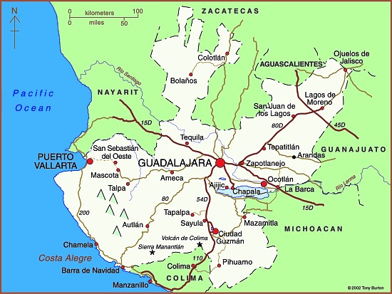
During the ten years between 2000 and 2010, Jalisco’s population increased by over a million from 6,322,002 to 7,350,355. Suburbs around Guadalajara dominated demographic change increasing by 887,301 (43.2%) to 2,940,118 (see Population change in the Guadalajara Metropolitan Area). The greatest growth was in the southern suburb of Tlajomulco which grew 237% from 123,619 to 416,552. Interestingly, the population of the central city of Guadalajara decreased by 152,185 to 1,494,134.

In this post, we look at the pattern of population change for the other municipalities in the state of Jalisco. The map shows the average annual percentage change in population for the period 2000-2010. It is worth noting that the population of a place with an annual growth rate of 3% will double in about 24 years.

Map of population change in Jalisco

Population change in Jalisco, 2000-2010. Copyright Tony Burton. Click image to enlarge.

What other areas of Jalisco are growing fastest?

Puerto Vallarta, the other major urban area in the state, grew by 38% to 255,725. The northern suburbs of Puerto Vallarta in the state of Nayarit grew even faster. The other major ex-pat area around Lake Chapala grew more slowly. Chapala grew by 12.4% to 48,812, Jocotepec by 18.0% to 42,142, while Poncitlan increased by 18.6% to 48,407.

Jalisco grew by 16.3% during the decade or an average increase of about 1.5% per year. But rates of population growth varied greatly from one area to another.

As indicated in the map, many of the isolated rural municipalities in the state actually declined in population (yellow-green and yellow areas). While births in these rural communities generally exceeded deaths, they experienced significant out migration.

In addition, many other rural communities in western Jalisco grew slowly at less than 1% per year (light pink on the map). Most of the communities in eastern Jalisco grew 1 – 2% about the same rate as the state as a whole.

Surprisingly, three of the most isolated municipalities in far northern Jalisco grew rapidly at over 3% per year. These municipalities are home to many indigenous Huichol Indians. Only relatively low numbers of Huichol Indians have migrated away from their ancestral homelands, so out-migration from these municipalities is much lower than from other remote parts of the state. In recent years, mining activity which was the mainstay of the economy of this area in colonial times, has made something of a comeback, thereby increasing local economic activity and opportunities.

Methodological note: The map depicts the municipal boundaries as they existed in the year 2000. Since that time, the municipality of Arandas has been split into two, reducing its territorial extent, and creating the new municipality of San Ignacio Cerro Gordo.

Dec 212015
 

The National Statistics Institute (INEGI) has released the results of its inter-census study carried out in March 2015 which involved visits to more than 7 million households across the country.

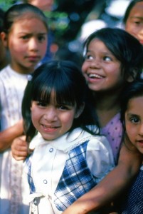
Children in Zitácuaro, Michoacán. Photo: Tony Burton. All rights reserved.

Children in Zitácuaro, Michoacán. Photo: Tony Burton. All rights reserved.

As of March 2015, Mexico’s total population was 119,530,753 (48.6% male, 51.4% female), up from 111,954,660 million in 2010, a growth rate averaging 1.4% a year. This is the first time for 45 years that the rate of growth has not fallen. Analysts had expected a 1.2% growth rate over the period, but attribute the 1.4% figure to a slightly higher fertility rate than anticipated, together with an unexpected fall in the number of young people emigrating from Mexico. [Note that the total population figure is slightly lower than the figure released in July from Mexico’s National Population Council (Conapo) of 121,783,280.]

Since 2010 the proportion of seniors (over age 65) has risen from 6.2% to 7.2% of the total, and the proportion of households headed by a female is up from 25% to 29%. The median age in Mexico is now 27 years. The youngest median age is in Chiapas (23), the oldest in the Federal District (33). Overall, Mexico’s dependency ratio is falling, continuing a period of “demographic dividend“.

INEGI found that the number of households in Mexico is rising 2.4% a year and now totals about 32 million, giving an average number of 3.7 occupants/household. 98.7% of homes have electricity, 74.1% have piped water inside the building, a further 20.4% outside the building but on the property; 75.6% connected to drainage.

Mexico’s most populated states remain the State of Mexico, the Federal District (Mexico City) and Veracruz, while the smallest states in terms of population are Baja California, Campeche and Colima. The most populated municipality is Iztapalapa (1.8 million), followed by Ecatepec (1.7 million) and Tijuana (1.6 million). The most rapidly growing municipality in the entire country is Pesquería, in Nuevo León, which has grown a startling 35.2% a year since 2010, mainly because of the new Kia vehicle factory opening there.

The item of inter-census news that attracted most press attention was INEGI’s so-called discovery that there were 1.4 million black Mexicans. This was hardly news to most demographers, but the inter-census survey was the first time INEGI had included a question aimed at identifying Afro-Mexicans, as a pilot question for the full 2020 census: “Based on your culture, history and traditions, do you consider yourself black, meaning Afro-Mexican or Afro-descendant?”

INEGI did indeed find that about 1.4 million citizens (1.2% of the population) self-identified as “Afro-Mexican” or “Afro-descendant”, with significantly more women opting for the category than men (755,000 women; 677,000 men).

It was no surprise to find that most Afro-Mexicans live in the states of Guerrero, Oaxaca and Veracruz. The survey showed that Mexico’s self-identified black population is not currently disadvantaged in terms of access to education and health services or work opportunities, putting it well ahead of Mexico’s indigenous population in that regard.

Afro-Mexican activists welcomed the inter-census question and results, but called for Mexico’s history books to reflect their contribution. Benigno Gallardo, an Afro-Mexican activist in Guerrero, pointed out that, “In school they teach our children about Europeans and indigenous natives, but the history books practically don’t recognize our history.”

Certainly more awareness of the long history of Afro-Mexicans is badly needed. For example, how many people realize that Blacks outnumbered Spaniards in Mexico until after 1810 or that Vasconcelas’ “Cosmic Race” (La “Raza Cósmica”) excluded Mexico’s African heritage?

Want to learn more? A good place to start is Bobby Vaughn’s website Afro-Mexico or his Black Mexico Home Page, Afro-Mexicans of the Costa Chica, on MexConnect, which provide links to several of his articles including Blacks in Mexico. A Brief Overview.

Related posts:

Oct 272014
 

The following account of Mexico’s traditional (folkloric) and introduced musical instruments consists of extracts from an article by Andrea Teter. [1]

Pre-Columbian instruments

Archaeologists have noted the existence of more than 1,400 musical instruments used in pre-Columbian Mexico and Central America. These were used primarily for religious, and healing rituals and for ceremonies, but also for war, dances, fiestas and entertainment. Some of these instruments, primarily the huehuetl, and teponaztli, both percussion, and the tlapitzalli, a four-hole flute, were considered divine or endowed with supernatural powers, say Mexican archeologists, and were worshiped as idols.

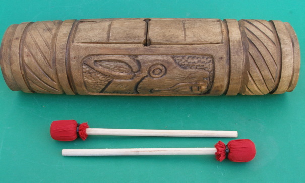
Teponaztli

Teponaztli

The Mexica (Aztecs) used flutes and trumpets made of clay, bamboo and metal. Drums, including the ayotl, made of tortoise shells, and other percussion instruments were used extensively. The huehuetl was the principal drum used by the Mexica and was made from animal skin stretched over a hollowed-out tree trunk. The teponaztli was made from hollowed-out trees or dried gourds, and sometimes gold and silver, with grooves or tongues cut into the top. Rich and varied tones are produced when played with small mallets. Pre-Columbian musicians also used cymbals, maracas, bells and even stones to produce their music.

The Youtube clip below is one interpretation of what some of Mexico’s indigenous musical instruments may have sounded like when played:

Europeans arrive

With the invasion of the Spanish, these musical instruments were immediately used to help convert the indigenous population to Christianity, while the Conquistadors began introducing European musical methods and instruments. A Franciscan missionary, Pedro de Gante, established the first music school in Mexico in 1523 and trained students in the construction and playing of European instruments.

Little by little, all of the European instruments were introduced to Latin America, starting in the 16th century with organs, guitars, harps and flutes, and later followed by the violins, trumpets, mandolins and accordions. Especially important and influential were guitars, which rose to prominence in the seventeenth century, as an easier-to-play alternative to the lute.

Six-string guitars, viheulas, became extremely popular in Mexico with other instruments of the same family also put into general use: five-string charangos, tiples, or treble guitars, and a large 12-string guitar similar to a bass, the bajo sexto.

Another string instrument that became popular in Mexico was the mandolin. The mandolin, which comes from Southern Italy, is the most recent development of the lute family. It was popularized in Mozart’s “Don Giovanni” and Verdi’s “Othello”.

The salterio, originally from Egypt, is a stringed instrument a little larger than a briefcase with a sound resembling a harpsichord and a playing method resembling a steel guitar or autoharp. The musician plucks the 97 strings while it rests on his knees; the sound is unique and quite beautiful.

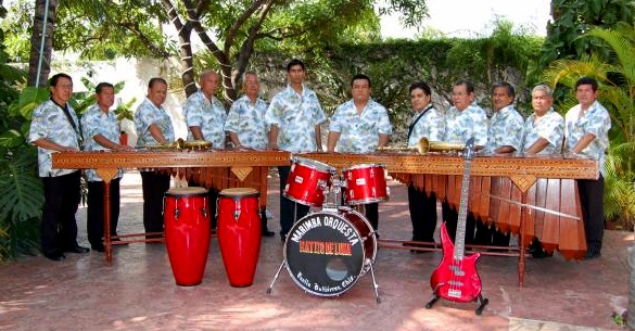
Once the Spanish began importing slaves from Africa, these blacks began constructing marimbas, which imitated the African xylophone. As early as 1545, a Spanish scribe in the state of Chiapas wrote of an instrument of eight wood bars played with heavy sticks by the local natives at tribal ceremonies. The modern sophisticated Mexican marimbas was developed by Chiapas musician Corazon Borraz, who in 1896 brilliantly added a second row of half-tone bars to the common single row (like a piano’s black keys) adding to the musical scope of the original instrument, allowing it to play more complex music.

marimba

A marimba band: two marimbas plus guitar and drums

Today, a concert marimba can be three meters long, have 70 keys and weigh more than 55 kilos. This grand instrument demands four musicians; the bass man at the wide end with two sticks or baguetas having small rubber balls on the striking tips. This end has long resonance boxes hanging below the sound keys. Then the harmonics man with one or two sticks in each hand above shorter resonance boxes. Then comes the melody maker and leader, wielding two sticks per hand; then the narrow end controlled by the treble master, a stick in each hand producing counterpoint to the melody. Talk about a compact orchestra!

The variety of instruments Mexican musicians and composers have access to has resulted in a distinctive music for this country. At least one Mexican composer, Carlos Chavez, has gained international fame with his integration of Mexican pre-Hispanic instruments in his works such as “Sinfonia India,” “Xochipilli” and “Macuilxochitl.”

Some Mexican composers have been even more innovative. For example, Julián Carrillo (nominated for the Nobel Prize in Physics in 1950), one of Mexico’s top violinists, invented a microtonal music system known as Sonido 13. The system became sufficiently famous that Carrillo’s birthplace in the state of San Luis Potosí felt obliged to rename itself Ahualulco del Sonido 13: an interesting place to visit for any geographers interested in microtonal music! Ahualulco del Sonido 13 is located 39 kilometers northwest of the city of San Luis Potosí. Leaving that city, first follow federal highway 49 towards Zacatecas and then turn north on the road signed Charcas.

Want to read more?

Note:

[1] The bibliographic details for Andrea Teter’s article are currently unknown. Please contact us if you are able to supply any further information about these extracts, so that we can update to include the full reference.

Related posts:

Study finds indigenous Mexicans far more diverse than previously thought

 Other  Comments Off on Study finds indigenous Mexicans far more diverse than previously thought
Jun 262014
 

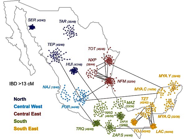
A recently released study [1] indicates that genetic diversity among indigenous Mexicans is far greater than previously thought. Ethnic Seri living in isolated parts of Sonora are as genetically different from isolated Lacandon living near the Guatemala border as Europeans are from Chinese. These differences must have existed for thousands of years before Europeans arrived in the New World. The differences are also reflected in mestizos living in geographically separated parts of Mexico.

Source: A. MORENO-ESTRADA ET AL., SCIENCE (2014)

Source: Moreno-Estrada et al. Science (2014)

The study in the June 13 issue of Science was conducted by researchers from the University of California, San Francisco and Stanford. They studied the genomic data from 511 native Mexicans from 20 of Mexico’s 65 indigenous groups scattered throughout Mexico (see map) from the Seri (SER) and Tarahumara (TAR) in the northwest, to the Purépecha (PUR) in the west, Trique (TRQ) and Zapotec (ZAP)in the south as well as three subgroups of Maya (MYA) on the Yucatán Peninsula [2]. They also analyzed similar data from 500 mestizos from ten Mexican states as well as some from Guadalajara and Los Angeles.

The findings have great implications for the study of diseases in these populations [3]. For example a lung capacity test can indicate a disease in one indigenous group while the same test results would be normal in a different indigenous group.

References:

[1] Moreno-Estrada et al. “The genetics of Mexico recapitulates Native American substructure and affects biomedical traits”, Science 13 June 2014; Vol 344 no.6189, p. 1301.

[2] Lizzie Wade. “People from Mexico show stunning amount of genetic diversity”, ScienceMag.org, June 12, 2014.

[3] Karen Weintaub,”Mexico’s Natives didn’t mix much, new study shows”, National Geographic, June 12, 2014.

Related posts:

Aug 222011
 

The proposed implementation of a United Nations-supported carbon storage program (REDD) in the southern Mexican state of Chiapas is provoking plenty of controversy. The debate is hotting up because a follow-up program called REDD+ is due to start in 2012. A good summary of the situation is provided by REDD rag to indigenous forest dwellers.

What is REDD?

  • REDD stands for Reducing Emissions from Deforestation and Forest Degradation
  • It is a carbon storage program, started in 2008 by the Food and Agriculture Organization (FAO), the U.N. Development Programme (UNDP) and the U.N. Environment Programme (UNEP).
  • It aims to conserve biodiversity and boost carbon storage by preventing deforestation and by replanting forests
  • It is focused on developing countries, and provides them wih funds and technical support

At first glance, it would seem like a good fit for Chiapas, one of Mexico’s poorest states, where a high proportion of the population are reliant on subsistence farming. The Chiapas state government backs REDD, considering it as one way of helping mitigate the likely consequences of climate change in the state. Chiapas’ total emissions of carbon dioxide amount to 32 million metric tons/year, about 4.5% of the national figure. The Chiapas contribution comes mainly from deforestation and farming.

NGOs working in Chiapas warn that REDD poses a serious threat to indigenous people. About 20% of the 4.8 million people living in Chiapas belong to one or other of the state’s numerous indigenous groups. Land tenure in many parts of Chiapas is hotly disputed; this was one of the reasons for the EZLN (Zapatista Army of National Liberation) uprising in 1994.

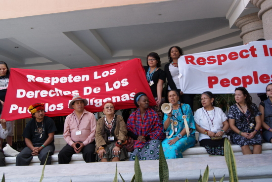
Protests in support of indigenous rights, Cancún climate summit

Protests in support of indigenous rights, Cancún climate summit, 2010

Miguel García, a spokesperson for an NGO founded in 1991 which supports indigenous groups and protects the environment, has been quoted as saying that REDD “will alter indigenous culture, will commodify it, giving commercial value to common assets like oxygen, water and biodiversity.” He is especially concerned that “resentment of and confrontation with the Zapatista grassroots supporters are being accentuated.”

As with so many geographic issues, there is no easy “right answer” here. The rights of indigenous groups need to be respected and their views taken into account, before any decision is made about the value of their forest home to global efforts to mitigate climate change.

This is one controversy we plan to follow as it plays out in coming months.

Want to read more?

Related posts:

Children of Mexico’s indigenous groups are disadvantaged from birth

 Mexico's geography in the Press  Comments Off on Children of Mexico’s indigenous groups are disadvantaged from birth
May 302011
 

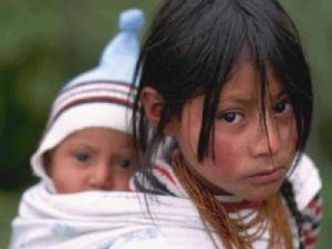
About 12% of Mexico’s population belongs to one or other of the numerous indigenous groups in the country. According to Mexico’s National Human Rights Commission (NHRC), Indian children under 5 years old are the group with the most needs in Mexico. They have a mortality rate that is 60% higher than that of non-Indian children.

Indigenous children in Mexico

Their disadvantages “increase when they belong to communities characterized by poverty, marginalization and discrimination.” Almost one-third of all children under 5 years of age belonging to Mexico’s indigenous population are below average height and weight. Illiteracy for this group is four times higher than the national average, because many of them leave school early to help their families make ends meet.

Related posts:

Chapter 10 of Geo-Mexico: the geography and dynamics of modern Mexico is devoted to Mexico’s indigenous peoples. Many other chapters of Geo-Mexico include significant discussion of the cultural and development issues facing Mexico’s indigenous groups.

Relying on geography for orientation: some indigenous languages do not have words for “left” or “right”

 Other  Comments Off on Relying on geography for orientation: some indigenous languages do not have words for “left” or “right”
May 242011
 

Mexico’s indigenous groups have long been a rich resource for investigations of all manner of research concerning culture, linguistics and sociology.

In this post, we consider Spatial Reasoning Skills in Tenejapan Mayans, a study relating to geographic reasoning, which relied on the participation of indigenous Tseltal-speaking Maya in Tenejapa (Chiapas), southern Mexico.

According to the inter-census population count in 2005, Tseltal (aka Tzeltal) is spoken by 371,730 individuals over the age of 5, making it Mexico’s fifth most-spoken indigenous language (after Náhautl, Maya or Yucatec Maya, Mixtec and Zapotec). More than 25% of Tseltal speakers are monolingual and do not speak Spanish. They reside in several municipalities of Chiapas, including Ocosingo, Altamirano, Tenejapa, Chanal, Sitalá, Amatenango del Valle, San Cristóbal de las Casas and Oxchuc.

Peggy Li, Linda Abarbanell and Anna Papafragou, the authors of the study, examined the “possible influences of language on thought in the domain of spatial reasoning.”

They distinguished between egocentric orientation and geocentric orientation:

“Language communities differ in their stock of reference frames (coordinate systems to reference locations and directions). English typically uses egocentrically-defined axes (“left-right”). Other languages like Tseltal lack such a system but use geocentrically-defined axes (“north-south”).”

They then compared how a group of Tseltal speakers tackled simple orientation tasks that required egocentric spatial reasoning skills. Their expectation was that Tseltal speakers would be poor at these tasks compared to a control group of Tseltal speakers who also spoke Spanish (which has many egocentric words).

Tzeltal elders
Tzeltal elders – looking right or left? Credit: Enrique Escalona, México D.F.

The expectation was that Tenejapans would find egocentric reasoning much harder than geocentric spatial reasoning since their language has no egocentric vocabulary for anything beyond their own bodies. [Tseltal “does have two “body part words “xin” (left) and “wa’el” (right)”, though they are never used for anything outside the body.] This expectation was based in part on an earlier anecdotal report that “a Tenejapan blindfolded and spun around 20 times in a darkened house was able to point in the agreed [compass] direction while still dizzy and blindfolded”.

To some people’s surprise, the Tseltal speakers were able to solve tasks requiring egocentric skills at a rate far higher than mere chance would suggest, and indeed with a higher success rate than tasks requiring geocentric skills. The researcher concluded that tasks requiring egocentric spatial orientation skills are actually easier than those requiring geocentric spatial orientation, and that the absence of “left/right” in a language does not necessarily translate into any conceptual gap.

If Tseltal speakers don’t use “left and right” to locate objects, how do they describe where things are?

“In place of egocentric coordinates, Tenejapans and other Tseltal speakers utilize a system of terms (“alan” and “ajk’ol”) based on the overall inclination of the terrain (“downhill” and “uphill”) which they inhabit. These geocentrically-defined terms are extended and used even when one is on flat terrain to reference the general directions of uphill and downhill which roughly correspond to the north-south axis. Moreover, they are used in descriptions of small scale arrays such as the arrangement of items on tabletops for which English speakers prefer “left” and “right.” ”

We hope the Tenejapans (each received 50 pesos for participating) did not give all their secrets away at once, but have saved some for the enlightenment of future researchers…

Li, P., Abarbanell, L.,& Papafragou, A. (2005). Spatial reasoning skills in Tenejapan Mayans. Proceedings from the 27th Annual Meeting of the Cognitive Science Society. Hillsdale, NJ: Erlbaum.

May 032011
 

Somewhat surprisingly, the number of Mexicans speaking indigenous languages has increased significantly in the past 20 years. In 2010 there were 6.7 million indigenous speakers over age five compared to 6.0 million in 2000 and 5.3 million in 1990.

There are two factors contributing to this finding:

  • First, indigenous speakers are teaching their children to speak their indigenous language.
  • Second, indigenous speakers have higher than average birth rates.

The number of indigenous speakers that cannot speak Spanish decreased slightly from 1.0 million in 2000 to 981,000 in 2010.

The most widely spoken indigenous languages are:

  • Nahuatl, with 1,587,884 million speakers, followed by
  • Maya (796,405),
  • Mixteca (494,454),
  • Tzeltal (474,298).
  • Zapotec (460,683), and
  • Tzotzil (429,168).

[Note: language names used here include all minor variants of the particular language]

About 62% of all indigenous language speakers live in rural areas, communities with under 2,500 inhabitants. Nearly 20% live in small towns between 2,500 and 15,000, while about 7% in larger towns, and 11% live in cities of over 100,000 population. Indigenous speaking areas tent to have low levels of development. Over 73% of the population In Mexico’s 125 least developed municipalities speak an indigenous language.

States with the most indigenous speakers tend to be in the south. In Oaxaca, almost 34% of the population over age three speak an indigenous language followed by Yucatán (30%), Chiapas (27%), Quintana Roo (16%) and Guerrero and Hidalgo (15%). States with the fewest indigenous speakers are Aguascalientes and Coahuila (0.2%), Guanajuato 90.53%) and Zacatecas (0.4%).

A total of 15.7 million Mexicans over age three consider themselves indigenous. Surprisingly, 9.1 million of these cannot speak any indigenous language. There are 400,000 Mexicans who can speak an indigenous language, but do not consider themselves indigenous.

Related posts:

Chapter 10 of Geo-Mexico: the geography and dynamics of modern Mexico is devoted to Mexico’s indigenous peoples. Many other chapters of Geo-Mexico include significant discussion of the cultural and development issues facing Mexico’s indigenous groups.

What questions were asked in Mexico’s 2010 population census?

 Other  Comments Off on What questions were asked in Mexico’s 2010 population census?
Nov 082010
 

In mid-2010, Mexico held a general census of its population and households. The majority of census respondents were required to complete a “basic questionnaire” of 29 questions, with a smaller number (2.7 million) asked to complete a “full questionnaire” with 75 questions.

The questions asked in the basic questionnaire (with a summary of the options for each response)  included:

Characteristics of the dwelling:

  • What are the floors made of? (earth/cement or concrete/wood, tiles or other)
  • How many rooms are used for sleeping (excluding passages)?
  • How many rooms are there in total, including the kitchen, but excluding passages or bathrooms?
  • Does the dwelling have electricity?
  • What is the water supply? (piped municipal supply/stand pipe/water piped from another dwelling/periodic water trucked in/river, well or lake)
  • Is the dwelling connected to a sewage system or septic tank?
  • Does the toilet have running water/water from buckets/no water?
  • Which of the following do the occupants of the dwelling own? – radio/television/refrigerator/washing machine/vehicle/computer/fixed line telephone/cell phone/internet.

Characteristics of each person in the household:

  • Sex, age, relation to head of household
  • Place of birth (state, if born in Mexico, or country, if born elsewhere)
  • Which medical services if any, do the occupants have access to? (IMSS, ISSSTE, Pemex or Armed Services, private provider, other, none)
  • Religion
  • Limitations in daily life? (walking, moving/vision, even when wearing glasses or contacts/speaking/hearing even when wearing a hearing aid/dressing, bathing, eating/learning simple new tasks/any form of mental difficulty/none)
  • Name of any dialect or indigenous language (ie other than Spanish) spoken

Education:

  • Are you currently enrolled in school, college or university?
  • Level of education already completed
  • Can you read and write a simple message?
  • Where did you reside 5 years ago? (state in Mexico, or country if outside Mexico)
  • Civil status (single/married/separated/divorced/widowed)

Employment

  • Last week, did you work at least one hour/have a job, but not work/look for work
  • Are you retired/student/homemaker/unable to work through physical or mental incapacity

Children

  • How many liveborn children have you had?
  • How many of these children have since died?

The first results from the 2010 census should be available from early next year. As results are published, Geo-Mexico will be updating facts and figures to highlight any important changes in Mexico’s geography.

The geography of languages in Mexico: Spanish and 62 indigenous languages

 Excerpts from Geo-Mexico  Comments Off on The geography of languages in Mexico: Spanish and 62 indigenous languages
Apr 232010
 

Most people realize that the national language of Mexico is Spanish and that Mexico is the world’s largest Spanish speaking country. In fact, its population, now numbering 105 million, represents about one-third of all the 330 million or so Spanish speakers in the world. Spanish is the majority language in nineteen other countries besides Mexico, and is the world’s third most spoken language, after English and Chinese.

Far fewer people realize that, in addition to Spanish, another 62 indigenous languages are also spoken in Mexico. This makes Mexico one of the most linguistically diverse countries in the world, in terms of the number of languages spoken, behind Papua New Guinea, Indonesia and India, but well ahead of China, Brazil and just about anywhere else.

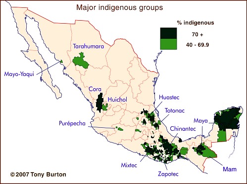
The major indigenous groups in Mexico

Some estimates put the number of different Indian languages in use at the time of the Spanish Conquest in the 16th century as high as 170. This number had dwindled to about 100 by 1900, and has continued to decline to the present day. The latest estimates are that at least 62 distinct languages (and 100 dialects) are still spoken somewhere in the country.

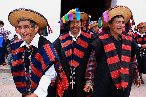
The largest indigenous groups are those speaking Nahuatl (2,563,000; dispersed locations, and therefore not shown on the map), Maya (1,490,000), Zapotec (785,000) and Mixtec (764,000), followed by those using Otomí (566,000), Tzeltal (547,000) and Tzotzil (514,000). Other well known groups include the 204,000 having Purépecha (or Tarasco) as their first language and the 122,000 speaking Tarahumara.

At the other end of the spectrum, only about 130 people still speak Lacandón and only 80 use Kiliwa. Only 60 people still use Aguacateco in Mexico and only 50 speak Techtiteco (or simply Teco), though both languages are spoken by several thousand Indians in neighboring Guatemala.

Of course, we shouldn’t forget that many Mexicans not only speak Spanish and/or an indigenous language, but also manage pretty well in English, French, Japanese and many others!

This is an edited version of an article originally published on MexConnect – click here for the original article

Indigenous languages and cultures are analyzed in chapters 10 of Geo-Mexico: the geography and dynamics of modern Mexico.

An overview of Mexico’s indigenous peoples

 Other  Comments Off on An overview of Mexico’s indigenous peoples
Apr 162010
 

How many indigenous people are there?

According to INEGI figures, about six million Mexicans over the age of five speak at least one indigenous language. Another three million Mexicans consider themselves indigenous but no longer speak any indigenous language.

How many indigenous towns or villages exist?

INEGI figures show that, in over 13,000 localities, more than 70% of the population speaks an indigenous language. Most of these localities are small rural settlements with fewer than 500 inhabitants. These settlements are often highly marginalized, with high levels of poverty.

Speaking an Indian language is associated with disadvantage

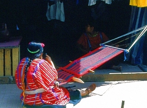
Oaxacan weaver. Photo: Tony Burton. All rights reserved

Speakers of indigenous languages fall way below the Mexican average on almost any socio-economic indicator. For instance, almost 33% of indigenous-speakers are illiterate, compared to a national rate of 9.5%. Females are particularly disadvantaged – indigenous females stay in school a full year less than their male counterparts, and for only half the time that the average non-indigenous female does. Even today, almost 5% of indigenous infants die before reaching their first birthday. A third of indigenous houses lack electricity; more than half do not have piped water.

Where do the indigenous people live?

More than 92% of the indigenous population lives in central and southern Mexico. With the notable exception of the 50,000+ Tarahumara Indians who live in the remote Copper Canyon region of Chihuahua, other indigenous groups in northern Mexico have relatively small populations.

The reason is largely historical. The major pre-Columbian civilizations in Mexico—Maya, Aztec, Zapotec, etc—developed in central or southern Mexico. The north always had fewer indigenous people. The disparity in numbers between north and south was heightened in early colonial times, as Spain expanded its territorial interests in New Spain along two major axes of economic development: the Mexico City-Veracruz corridor (the major trade route linking the capital to the port and Europe) and the Mexico City-Zacatecas corridor (the major route linking the capital to valuable agricultural and mining areas). It is no coincidence that indigenous languages and customs first died out along these corridors, as the indigenous people were forced to become assimilated into the developing dominant culture.

Indigenous peoples and languages did much better in the south. At last count, Oaxaca has over one million indigenous speakers representing more than a third of the state’s population. The state’s largest indigenous linguistic groups are the Zapotec, Mixtec, Mazatec, Chinantec, and Mixe. Oaxaca’s ethnic diversity is celebrated in the annual Guelaguetza festival, normally held in July.

Chiapas has almost as many indigenous speakers as Oaxaca. The largest indigenous groups in Chiapas are the Tzotzil, Tzeltal and Chol. One numerically-small Chiapas group is the Mam. Its recent history is an interesting study in how an indigenous group can re-invent itself in order to survive in the modern world.

The population figures quoted in this post are from INEGI’s Census and II Conteo de Población y Vivienda 2005 (INEGI, Aguascalientes).

Click here for original article on MexConnect

Chapter 10 of Geo-Mexico: the geography and dynamics of modern Mexico is devoted to Mexico’s indigenous peoples. Many other chapters of Geo-Mexico include significant discussion of the characteristics of, and development issues facing, Mexico’s many indigenous peoples.

The pattern of severe poverty within Mexico

 Updates to Geo-Mexico  Comments Off on The pattern of severe poverty within Mexico
Jul 142014
 

As presented in a previous post, 2.8% of Mexicans (3.3 million) live in severe poverty based on a June 2014 Multidimensional Poverty Index (MPI) developed by the Oxford (University) Poverty & Human Development Initiative (OPHI)[1]. The previous post explained the MPI measure of poverty and discussed how Mexico compared to the 108 countries in the study. This post looks into the details of MPI poverty within Mexico. Poverty in Mexico is mostly a rural problem. According to the study, roughly 8.5% of rural residents are severely poor (2.3 million) compared to only 1.1% of people in urban areas (1.0 million).

As indicated in the previous post, the MPI is based on ten separate indicators; two for education, two for health and six for standard of living. In all cases, people in urban areas scored better on all the indicators than those in rural areas. In rural areas several key MPI indicators contribute the most to poverty: insufficient schooling (19.3%), malnutrition (14.1%), children not attending school (12.9%), use of an unhealthy cooking fuel (12.9%) and unacceptable sanitation (11.7%) [2].

As expected the poorer more rural southern states had the highest MPI poverty levels. Oaxaca had the most living in poverty (11.1%) followed by Guerrero (10.6%) and Chiapas (8.3). Poverty was also high in San Luis Potosí (6.7%), Puebla (5.3%), Veracruz (4.6%), Campeche (4.2%), and Hidalgo (3.4%). These states all have significant indigenous populations. Though the study did not access severe poverty among indigenous groups, available information suggests that those groups suffer by far the highest levels of severe poverty. States with lowest MPI levels are Nuevo León (0.2%), Federal District (0.4%), Baja California (0.4%), Baja California Sur (0.4%), Durango (0.7%), Morelos (1.0%), Colima (1.0%), and Aguascalientes (1.0%); all states with relatively few indigenous inhabitants.

References:

[1] Oxford Poverty and Human Development Initiative (OPHI), “Global MPI Data Tables for 2014”, Oxford University, June 2014.

[2] Oxford Poverty and Human Development Initiative (OPHI), “OPHI Country Briefing 2014: Mexico,”

Related posts:


The settlement patterns of the Tarahumara in Mexico’s Copper Canyon region

 Other  Comments Off on The settlement patterns of the Tarahumara in Mexico’s Copper Canyon region
Aug 132012
 

To understand the distinctive settlement patterns of the Tarahumara today, we first need to romp through a thumbnail history covering their experiences during the years following the Spanish Conquest.

While it is uncertain precisely when the Tarahumara arrived in this area, or where they came from, the archaeological evidence seems to support the view that they probably only arrived a short time before the Spanish reached the New World. By 1500 A.D., the Tarahumara had stone dwellings, simple blankets of agave fiber, stone “metates” (pestles), and combined hunting and gathering with the cultivation of corn (maize) and gourds. Settlements at this time would have been small and scattered, with no more than a few families able to survive in any given area. Then the Spanish arrived.

In early colonial times, Spanish explorers and clerics gradually moved ever further north of Mexico City. The first twelve Jesuits had arrived in New Spain in 1572; more arrived in 1576 and by 1580, they had already established centers for their work in Michoacán (1573), Guadalajara (1574), Oaxaca (1575), Veracruz (1578) and Puebla (1580).  However, the inaccessibility of the Copper Canyon area prevented them from extending northwards as fast as they had hoped.The first important Spanish contact with the Tarahumara dates from around 1610 when a Jesuit missionary, Juan Fonte, established a mission at San Pablo de Balleza. This mission, located between the traditional territories of the Tarahumara and the neighboring Tepehuan Indians, was short-lived. In 1616, a Tepehuan‑inspired revolt led to Fonte’s death. Several hundred Spaniards along with thousands of Indians were killed in the ensuing two years of conflict.

During the remainder of the 17th century, however, the Jesuits made a steady advance, establishing numerous missions including Sisoguichi, which is still the center of their influence today. These Jesuit missions were a clerical modification of the encomienda system, an institution designed to help spread Spanish civilization, by rewarding chosen settlers with the right to collect tributes and labor from the indigenous population. The Jesuit missions usually had two friars teaching religion, handicrafts, agriculture and self‑government, together with a few soldiers for protection.

As early as 1645, some Tarahumara were working in mines, some as slaves, others voluntarily for wages. This is when both the Jesuits and the mine operators encouraged the Indians to relocate and concentrate their homes in villages or towns. This major change in settlement pattern facilitated the provision of religion and education and made it easier to organize the labor force. The Tarahumara resisted this move more strongly than other indigenous groups did elsewhere in New Spain.

The early Jesuit/Tarahumara contacts were relatively friendly, but disillusionment soon set in and around 1650 the Tarahumara essentially split into two opposing factions, the “baptizados” (Christians) and the “gentiles” (unconverted). The former decided that the priests offered a worthwhile alternative to their traditional way of life and remained in the missions. The gentiles, blaming the Spanish God for widespread epidemics, withdrew into the difficult terrain of mountains and canyons of the Copper Canyon region, effectively trying to avoid any further contact with the Spanish. Later rebellions by the gentiles , such as that in the 1690s, were brutally put down by Spanish troops. This ended Tarahumara military resistance but ensured that they withdrew still further into the canyons.

The mission settlements

The two groups of Tarahumara now have very different settlement patterns, and some significant differences in their way of life. The baptizados live in mission villages, many of which are located east of the true canyon region, where valleys offer ample arable land and better possibilities for highways and communications. The settlements are nucleated, with homes built close to the protection of the church, and farmland surrounding the villages. These villages attracted many mestizo settlers, who saw opportunities in agriculture, forestry and commerce. Intermarriage became more common and the Tarahumara’s social customs changed as they assimilated more mestizo habits and became more Mexicanized.
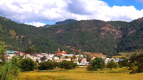
Cerocahui

The mission settlement of Cerocahui

The largest settlement in the region is Creel, a much more modern town, founded in 1906. The town received a massive boost following the completion of the railway between Creel and Chihuahua in 1907, and again in the 1960s when the “Copper Canyon” railway to Los Mochis and Topolobampo was finally completed.

Creel has also benefited in the past decade from its designation as one of Mexico’s Magic Towns and has received significant investments in tourist and urban infrastructure. Set at an elevation of 2340 m (7,600 feet) above sea level, Creel lies some distance from the nearest canyon, but has become the main marketing, lumber and tourist center and the gateway for trips into the more remote areas. Its population is about 6500.

Twenty kilometers from Creel is Cusárare (“Place of Eagles”), a typical mission village. The simple mission church, originally erected in 1767, was rebuilt in the 1970s. The village has a few small “corner” stores, some also selling tourist souvenirs. Less than an hour’s walk away is Painted Cave, a good-sized cave with pictographs said to have been left by the “Ancient Ones”. In the mid‑1890s, ethnologist Carl Lumholtz wrote that “there are no Mexicans [as opposed to Indians] living in Cusárare, nor nearby. Except for the small mining camp in the Copper Canyon, there are none for more than 50 miles to south, east or west.”

The gentiles‘ settlements

The traditional Tarahumara, the gentiles, are less Mexicanized, though they continue to use introduced crops, animals and agricultural implements acquired from the Spanish priests and settlers. Restricted to marginal land on the canyons’ rims and walls, they live in small, variable‑sized, dispersed settlements, often several hours apart by foot. This pattern is no surprise, given the extremes of topography that characterize the area, the limited technology (plow agriculture) available to them, and their need for spatial mobility to ensure access to grazing land for small herds of sheep and goats.

In these marginal areas, only small pockets of potentially arable land exist and many families have plots of land scattered about a considerable area, with several hours’ walk between plots. The population of their dispersed settlements (ranchos) is variable, depending on the available resources of land and water, on the pattern of marriages, and on the amount of inherited land in other ranchos, but averages between 2 and 5 family groups, a total of between 10 and 25 individuals.
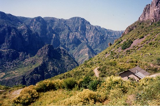
The serious challenge is finding any land suitable for farming

The serious challenge is finding any land suitable for farming. Photo: Tony Burton; all rights reserved.

The homes are often perched on the gently sloping tops of the steep-sided spurs that jut out from the canyon rim, affording spectacular views, but with dangerous drop-offs beyond the areas suitable for settlement and cultivation. Individual dwellings used to be stone and mud huts, or caves in the canyon wall. The Tarahumara’s skill with the axe (a 17th century introduction) is considerable and, today, houses and other structures are made almost entirely of wood, though many caves are still inhabited, at least for part of the year. Caves which face south are preferred and their position on distant hillsides is often marked by a black, smoke‑darkened upper rim.

Perhaps the best‑built structures are their storage boxes which are wooden cubes (side about 2 m) where notched hand‑hewn planks are fitted together so tightly that not even a mouse can gain access. These structures are raised about 50 cm off the ground, usually on boulders, and have wooden roof singles. They are used to store not only food but also animal hides, horsehair ropes, simple implements, cloth, yarn and anything considered valuable. Where wood is harder to obtain, they are built of stones and mud.

Their houses are constructed in a similar fashion, but with less attention to detail. Their houses are not, therefore, very permanent. Indeed, one ancient Indian tradition holds that when a member of the household dies, the house should be abandoned or destroyed. Nowadays, the family simply moves the structure a few hundred meters and rebuilds it. The houses have dirt floors and minimal furnishings, such as wooden benches and stumps, items for food preparation, metal plates and a bucket and some animal (goat or cow) skins for sleeping on. There may also be some rough blankets and a homemade violin.

Most gentiles have more than one dwelling since they wander far afield with their animals in search of pasture and food, and since many practice a form of transhumance, spending winters near the canyon floor and summers near the canyon rim.

Sources /  Bibliography:

  1. Bennett, W. and Zingg, R. (1935) The Tarahumara. Univ. of Chicago Press. Reprinted by Rio Grande Press, 1976. Classic anthropological work.
  2. Dunne, P.M. (1948) Early Jesuit Missions in Tarahumara. Univ. Calif. Press.
  3. Kennedy, J.G. (1978) Tarahumara of the Sierra Madre; Beer, Ecology and Social Organization, AHM Publishing Corp, Arlington Heights, Illinois. Republished, as The Tarahumara of the Sierra Madre: Survivors on the Canyon’s Edge in 1996. This anthropologist lived in one of the more remote Tarahumara areas for several months, accompanied by his wife and infant daughter.
  4. Lumholtz, C. (1902) Unknown Mexico. 2 volumes. Scribner’s Sons, New York. Republished in both English and Spanish, this is a fascinating ethnographic account dating back to the end of the 19th century.
  5. Pennington, C. (1963) The Tarahumar of Mexico, their environment and material culture. Univ. of Utah Press. The reprint by Editorial Agata, Guadalajara, 1996, of this classic account of Tarahumara life and culture is embellished with wonderful color photographs, taken by Luis Verplancken, S.J. (1926-2004), who ran the mission in Creel for many years.

Related posts:

The important but often overlooked state of Puebla

 Other  Comments Off on The important but often overlooked state of Puebla
Dec 022011
 

The interesting and important state of Puebla is often overlooked because it is overshadowed by nearby Mexico City. In fact the western state border of Puebla is within 35 kilometers of the eastern edge of the Federal District. The state of Puebla also may be overlooked because it is rather small in area, ranking only 21st among Mexico’s 32 states. On the other hand, its 2010 population of nearly 5.8 million ranks it 5th behind only Mexico State, the Mexico City Federal District, Veracruz and Jalisco.

Though small in size, Puebla is very diverse. The topography is rugged and elevations range from under 100 meters in the northeast to volcanoes  rising over 5,000 meters above sea level, both to the east (Orizaba – 5,636m) and west (Popocatepetl – 5,410m and Iztaccihuatl – 5,230m). These extremes in elevation give Puebla a very wide range of climates and ecosystems, from semi-tropical rainforests and grasslands to highland forests and alpine ice packs.

Almost inevitably, given its high population density (168.5 inhabitants/square kilometer), many of these ecosystems have been degraded. Several of the most attractive natural areas are now protected. They include the Izta-Popo Zoquiapán, La Malinche and Pico de Orizaba National Parks as well as the very large Tehuacán-Cuicatlán Biosphere Reserve, which has over 100 different mammal species, 16 of which exist nowhere else on the planet.

Puebla also has significant social and ethnic diversity. There are numerous wealthy people and upscale areas in Puebla City, which has the eighth highest 2005 Human Development Index (HDI) score among major Mexican cities, behind only Mexico City, Chihuahua City, Monterrey, Querétaro City, Cancún, Torreón and Cuernavaca. Most people are surprised it comes out ahead of Guadalajara and Zapopan.

On the other hand, the state as a whole is rather poor. Based on its relatively poor levels of infant mortality, literacy, school enrollment, and income levels, the state ranks 28th of 32 states in terms of 2008 Human Development Index. Puebla is tied with Michoacán and ahead of only Chiapas, Guerrero and Oaxaca[1]. It also ranks 28th in illiteracy which is over 10% (2010); however 96% of the 6 to 11-year-olds now attend school, and illiteracy for those between the ages of 15 and 25 is less than 3%. While 98% of homes now have electricity, over half of Puebla’s workers make less than $115 pesos ($8.20US) a day. Approximately two/thirds of the state’s population live below the Mexican poverty line. The state’s high level of poverty is partially due to its indigenous population of almost one million and the fact that almost 30% of its inhabitants live in rural areas, some of them quite remote.

The city of Puebla is the heart of a Metropolitan Area which extends across state lines to the city of Tlaxcala. Metropolitan Puebla-Tlaxcala is the country’s 4th largest urban area with a population over 3.1 million, but is overshadowed by Mexico City, the eastern edge of which is less than 30 minutes by expressway. In fact, some urban specialists suggest that these two major metropolitan areas may merge in the future. On the other hand, the mighty Popocatepetl and Iztaccihuatl volcanoes, both over 5,000 meters in height, lie directly between the two cities. The high speed expressway skirts around the north side of the volcanoes.

The city of Puebla has long had strategic significance. The city was initially established during the colonial period owing to its strategic location between Mexico City and Veracruz, the dominant port for shipments to and from Spain. Puebla was the country’s second largest city for more than three centuries up until the mid 19th century. The Mexico City-Puebla railway was completed in 1869, but the main line to Veracruz bypassed the city, which diminished its comparative advantage, and resulted in it dropping to fourth place, overtaken by Guadalajara and Monterrey.

The state’s historical importance is evidenced by numerous important military confrontations, including the massacre of Cholula (1519), Santa Ana’s siege of Puebla City (1845), American General Winfield Scott’s occupation (1845-48), the “Cinco de Mayo” battle of Puebla against the French (1862), the French victory in the Second Battle of Puebla (1863), and occupation by the Zapatistas during the Mexican Revolution. The state is the birthplace of four Mexican Presidents: Ignacio Comonfort (1855–1858), Juan N. Méndez (1876–1877), Manuel Ávila Camacho (1940–1946) and Gustavo Díaz Ordaz (1964–1970).

Despite the state’s relative poverty, industrial development has been significant and Puebla has become one of Mexico’s most industrialized states. Since colonial times Puebla has been an important center for the textile and ceramic industries. Much of Mexico’s famous talavera pottery is made in Puebla. Talavera came to Puebla from Talavera, Spain, which in turn had acquired it from Arab traders who originally brought it from China.

Since the mid 20th century Puebla has become a very important modern industrial area. The most important manufacturing activities are metals, chemicals, electronics, textiles and particularly motor vehicles. The Volkswagen plant in Puebla is one of the largest outside Germany. In July 2003 it produced the very last of the over 21 million old “Beetles” built by VW. The plant now produces New Beetles, Jettas and Boras that are exported worldwide. The motor vehicle assembly industry is supported by scores of automobile parts factories in the state.

Related articles:

Veracruz: one of Mexico’s most diverse states

 Other  Comments Off on Veracruz: one of Mexico’s most diverse states
Oct 242011
 

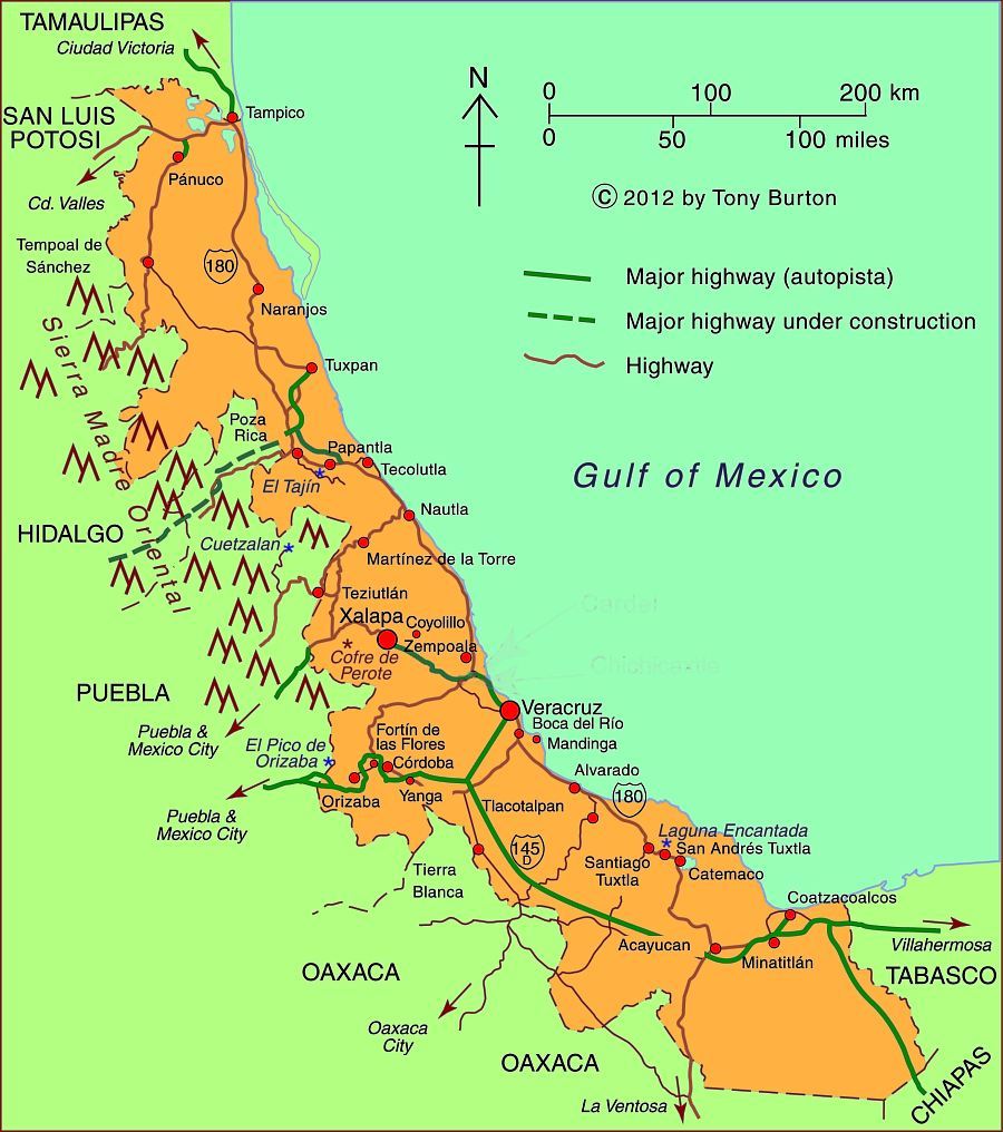
Veracruz, one of Mexico’s most important and interesting states, is a narrow strip of land stretching for 650 kilometers (over 400 miles) along the Gulf of Mexico. The topography ranges from a narrow coastal plain to very high mountains on its western border including Mt. Orizaba, Mexico’s highest peak at 5,610 meters (18,406 ft.).

The relief helps to funnel migrating birds into a narrow band across the state:

Veracruz which is one of the rainiest states has three of Mexico’s five largest rivers: the Panuco in the north and the Papaloapan and Coatzacoalcos rivers in the south. Its varied climate and ecosystems mean enormous biodiversity, including species of insects, birds and plants that exist nowhere else on earth. These species are protected in 31 protected areas including three national parks. Previous posts describe the fabulously beautiful Las Tuxtlas Biosphere Reserve and the mysterious Laguna Encantada.

With over 7.6 million residents, Veracruz trails only the State of Mexico and the Federal District in population. While the state is over one-third rural, it has several major metropolitan areas. The state capital is Xalapa (809,000). Other major cities include the industrial twin cities of Coatzacoalcos (234,000) and Minatitlán (356,000) in the extreme south, and the port city of Veracruz (703,000) in the center. The north of the state is served by the port city of Tampico (803,000) on the north bank of the Panuco River in the neighboring state of Tamaulipas.

One of the most interesting towns is Yanga, which was established around 1570 by escaped slaves lead by Gaspar Yanga. The town, the first African-ruled settlement in the New World, successfully resisted efforts by the colonial government to recapture it and its residents. Today, Gaspar Yanga is considered a national hero. It is interesting to note that Negroid features are apparent on the ancient 3,500 year old Olmec carved stone heads found in southern Veracruz. The state is home to numerous indigenous groups including the Nahuas, Huastecos, Otomis, Totonacs.

Map of Veracruz state, Mexico; all rights reserved.

Map of Veracruz state, Mexico; all rights reserved. Click to enlarge.

There are two UNESCO-designated World Heritage sites in Veracruz: the Pre-Hispanic city of El Tajin and the Historic Monuments of the Zone of Tlacotalpan.

Veracruz is one of Mexico’s poorer states. Mostly as a result of its very large rural, agricultural and indigenous populations, Veracruz ranks in the bottom third in most socioeconomic indicators such as production/person, percent living below the poverty level, human development index, literacy, infant mortality, life expectancy and marginalization. On the other hand, these indicators for the major cities are above the national averages.

Veracruz is second in total agricultural production behind only Jalisco. It produces more than half of the country’s sugar cane and oranges and also leads in mangoes and other citrus fruits. It is also a major producer of coffee, beef, pork, dairy, chicken, corn, beans, bananas, tobacco, coconuts, vegetables and vanilla.

Petroleum is extremely important. Most of the oil production is in northern Veracruz while the southern cities of Coatzacoalcos and Minatitlán are noted for their chemical and petrochemical industries.

Veracruz is also famous historically and culturally. Cortés and his men landed in Veracruz on their way to conquering and subduing all of Mexico. Veracruz city was the most important port for many centuries when it served as Mexico’s main link to the rest of the world. The state capital was eventually moved to Xalapa, which has a flourishing cultural life and an anthropology museum second only to the National Anthropology Museum in Mexico City. The annual Carnival staged in Veracruz is one of the most spectacular in all of Mexico. The Danza de los Voladores (Dance of the Flyers) in Papantla is a major tourist attraction for Mexicans and foreigners alike. Veracruz also has its own distinctive music and cuisine, enhancing its regional identity.

Sep 032011
 

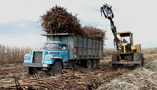
The sugar industry accounts for 0.5% of national GDP. Sugarcane fields cover 670,000 hectares (1.6 million acres) in Mexico, the second largest crop area after corn. Yields of sugarcane range from 60-70 metric tons/hectare.

Main growing areas in Mexico

The main cane producing states are: Veracruz (1.9 million metric tons), San Luis Potosí and Jalisco (each 0.6 million), Oaxaca and Chiapas (each 0.3 million), and Nayarit, Tamaulipas and Morelos (each 0.2 million). Veracruz is the leading state by far in terms of area of sugarcane fields, with 260,000 hectares devoted to cane, folled by Jalisco, San Luis Potosí and Oaxaca (each with around 56,000 ha) and Tamaulipas (43,000 ha).

SugarcaneSugarcane fields and their associated sugar mills form a highly distinctive landscape in many parts of Mexico, with the greatest concentrations on the coastal plains on the Gulf and Pacific coasts, together with numerous higher-altitude river valleys in central Mexico.

History and land tenure

Sugarcane was brought to Mexico by Spanish settlers. Many major plantations were established, as they were in the Caribbean and Brazil. Mexico’s indigenous population provided a resident labor force, augmented by the introduction of some slaves from Africa (see Blacks outnumbered Spaniards in Mexico until after 1810).

The large colonial sugar haciendas in Mexico (and some were very, very large indeed) exerted considerable influence over politics and local economies. Sugarcane remained an important crop following the Mexican Revolution (1910 onwards) which led to rural reorganization and much stricter controls on the size of land holdings. Sugarcane is grown on 150,000 farms, making their average size small, under 4.5 hectares (11 acres) each. This is partly a consequence of the Mexican Revolution which limited maximum farm size. About half of all sugarcane production units are 2 hectares or less in area. The small average size of sugarcane farms places severe restrictions on possible investments and effectively prevents any economies of scale.

Employment

The sugarcane sector employs about two million people directly and indirectly. The number of direct jobs includes:

  • 150,000 growers
  • 100,000 seasonal sugarcane cutters
  • 20,000 cane transport workers
  • 30,000 sugarmill workers
  • 7,000 administrative, technical and management personnel

Harvesting and production

The annual harvesting of sugarcane in Mexico runs from late October to June. During the 2010-2011 harvest, 670,000 hectares of cane fields were cut yielding 44 million metric tons of cane, from which 5.2 million metric tons of sugar was extracted, 7.4% more than for the 2009-2010 harvest.

Sugar mills

More than 50 sugar mills currently operate in Mexico. The mills vary greatly in size, age and technology. Many are small, old and inefficient, which increases the cost of sugar production in Mexico compared to countries with newer methods and equipment. Mexico’s sugar mills have weathered numerous financial crises. In 2001, 27 mills were placed under government control, with about half of these mills later sold back to private ownership. In 2005, a revised Sugarcane Law guaranteed a basic reference price for growers, improving their financial security. Almost half of all Mexico’s sugar mills are located in Veracruz state. The remaining sugar mills are scattered among an additional 15 states.

Domestic consumption of sugar

Mexico’s domestic market consumes around 4.5 million metric tons a year, with the largest demand coming from the soft drinks industry. Consumption is expected to fall this year, due to reduced consumer purchasing power and escalating domestic prices for sugar fueled by speculation and supply shortages.

Sugar exports

Mexico is the world’s 6th largest exporter of sugarcane, and the main supplier of sugar to the USA. For the 2010-2011 season, sugar exports to the USA totaled  a record 1.3 million metric tons. This figure has been increasing rapidly in recent years, partly due to sugarcane’s inclusion under the terms of NAFTA.

Despite its exports, Mexico also imports small quantities of sugar, mainly from Nicaragua in order to maintain its own sugar reserves of around 1 million tons.

The challenges faced by Mexico’s sugar industry

Mexico’s sugarcane industry faces numerous serious challenges, including:

  • poor drainage of soils in some areas
  • winter frosts in some mountain areas, especially in the more northerly growing regions.
  • limited rainfall – cane requires 1100–1500 mm (43–60″) of precipitation a year; unreliable precipitation, especially periods of drought, are a major problem, especially in Veracruz where irrigation systems are inadequate
  • level of production inputs (fertilizers, pesticides, etc)
  • transport costs which contribute to the high price of sugarcane in Mexico
  • small size of production units which limits investment and improvements
  • low efficiency of older sugar mills

Environmental degradaion

Environmental degradation is one of the most serious issues facing Mexico’s sugar industry, given the nature of sugarcane processing and the age of many of Mexico’s sugar mills:

  • much of Mexico’s cane is still hand-cut, and burning the cane fields prior to harvest is still a common practice, since it makes harvesting easier and drives out snakes. However, it has an adverse effect on air quality as well as on soil nutrients, structure and microorganisms.
  • Large volumes of water are used in growing and processing sugarcane. Much is wasted; some is returned to groundwater sources or streams heavily polluted. More recycling and water treatment plants are needed.
  • Air pollution is also a problem with some mills still to fit modern emissions control devices.
  • The safe disposal of processing waste (some of which has potential value for subsequent use in other industries) is also a continuing problem. Sugar mills produce a variety of waste materials, many of which are currently dumped.

Further reading:

Jul 112011
 

Many Chicano activists refer to Mexicans as “La Raza”, literally “the race”. “Dia de la Raza” is celebrated on Columbus Day (October 12) as the day the Mexican indigenous population started their resistance against the European invasion.

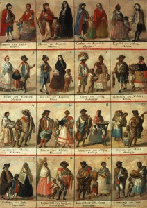
Racial classification in colonial times

Racial classification in colonial times (Click to enlarge)

The term “La Raza” derives from a 1948 book “La Raza Cósmica.” The author Jose Vasconcelos’ thesis is that Mexicans (who he defines as a combination of indigenous and European bloodlines) are a new superior race. In developing his thesis, Vasconcelos draws upon many concepts including Marxism; he felt Europeans were too materialistic and capitalistic. He suggested that Mexicans have evolved (à la Darwin) into a new race that would be a world leader in the years ahead. The Government of Mexico tacitly agreed with this approach which engendered national pride. It was also consistent with the government’s post Mexican Revolution view that all ethnic groups should be combined into a common Mexican national identity.

According to the 2010 census, about 15% consider themselves indigenous, though about 58% of these do not speak any indigenous language. Assuming the “white” and “other” categories are still about 10% and 2% respectively, this suggests that today about 73% are mestizos. Almost all people in Mexico refer to themselves simply as “Mexicans”, not as indigenous Mexicans or mestizos or whites.

Vasconcelos’ “Raza Cósmica” and most Mexicans overlook the historical fact that Mexicans have an important African heritage. Between 100,000 to 200,000 African slaves were brought into Mexico during the 16th through 18th centuries, nearly a quarter the number brought to the USA. In 1646 there were 35,000 African slaves in Mexico, more than 2.5 times the white population [see Blacks outnumbered Spaniards in Mexico until after 1810]. These slaves represented about 12% of the total population, roughly equal to the percentage of slaves in the USA before 1860.

Mexico’s second president, Vicente Guerrero, whose mother was partially Black, abolished slavery in 1829. Thousands of Blacks moved into Mexico from the USA before it abolished slavery in 1865. However, today there are very very few black faces in Mexico. One can spend weeks in Mexico’s major cities without seeing a Black Mexican. If one pays close attention, they can identify people of African heritage in a few selected communities in Veracruz and along the Costa Chica in Guerrero and Oaxaca [Bobby Vaughn’s homepage: Afro-Mexicans of Costa Chica ].

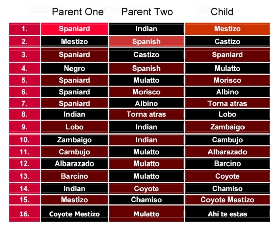
What happened to all the Blacks in Mexico?  [Blacks in Mexico] In a word they assimilated by having offspring with other racial groups. In colonial times, the Catholic Church went to great lengths to categorize intermixed races for marital and baptism purposes:

The terminology for racial mixes

Complex terminology for racial mixes

Before too long, nobody could keep all the combinations straight! Eventually, everyone of mixed race was considered a mestizo. The African portion was purposely or accidentally dropped.

Modern research, based on DNA, indicates that Mexican mestizos are genetically about one-eighth African [mtDNA Affinities of the Peoples of North-Central Mexico]. While Brazil is often identified as the world’s foremost melting pot, the evidence suggests that in Mexico the races have melted more than in any other country.

While there are very few black faces in Mexico, there is a great deal of African heritage represented in art, music, dance, food, and even in fishing and agricultural practices. Did you know that the popular Mexican song “La Bamba” recorded by Richie Valens, Los Lobos and others can be traced back to the Bamba district of Angola? As part of the 500th anniversary of Columbus’ famous voyage, the Government of Mexico finally acknowledged officially that Africa was Mexico’s “Third Root”.

Marriage declining among Mexican couples

 Updates to Geo-Mexico  Comments Off on Marriage declining among Mexican couples
May 312011
 

Mexican couples still prefer marriage over the alternatives, but not as strongly as in the past. According to the 2010 census, 40.5% Mexicans age 12 and over were married, down from 44.5% in 2000 and 45.8% in 2009. The 11% decline since 1990 does not sound like much, but is significant when the data are investigated more deeply.

Because the data include all Mexicans over age 12, it is not surprising that 35.2% were single in 2010, compared to 37.2% in 2000 and 40.6% in 1990. The 13% drop since 1990 in the percentage for singles is mostly a result of the relative decline in the total number of teenagers, most of whom are unmarried, as a consequence of the decline in fertility over the past few decades.

The most impressive growth was for “free union” couples, those living together but not married. In terms of population, the proportion went from 7.4% in 1990 to 10.3% in 2000 and 14.4% in 2010, almost double the 1990 level. If we compare married couples with those in free union, we get an even clearer picture of the trend. In 1990, 13.9% of all couples lived in a “free union”; this figure increased to 18.8% in 2000 and 26.2% in 2010.

While roughly three of every four couples in Mexico are married, this varies significantly from state to state. It is not surprising that the least Catholic state—Chiapas— has the most couples living in “free union” – 38.8%. Chiapas also is one the most heavily indigenous states. But even in Chiapas, over six in ten couples are married. Other states with high rates of “free union” couples are Baja California (35.5%), Nayarit (34.5%), Baja California Sur (34.4%) and Quintana Roo (34.4%), a state with relatively few Catholics and a substantial indigenous population. The most Catholic state of all—Guanajuato—has the fewest “free union” couples, only 13.4%. Other states with relatively few unmarried couples are Yucatán (14.1%), Zacatecas (15.3%), Nuevo León (15.6%) and Aguascalientes (16.0%).

The census also includes three additional categories which all have increased rather rapidly since 1990. Those widowed went from 3.6% in 1990 to 4.3% in 2000 and 4.4% in 2010. This probably is a function of increasing life expectancy and people living longer on their own after their spouse dies, especially if the death resulted from an accident or violence. Separation, though still rather rare, is becoming more common, increasing from 1.2% in 1990 to 2.6% in 2000 and 3.7% in 2010. Divorce is also quite uncommon but increasing, from 0.7% in 1990 to 1.0% in 2000 and 1.5% in 2010.

Oct 222010
 

By common consent, the history of blacks in what-is-now Mexico is a long one. The first black slave to set foot in Mexico is thought to have been Juan Cortés. He accompanied the conquistadors in 1519. It has been claimed that some natives thought he must be a god, since they had never seen a black man before.

A few years later, six blacks are believed to have taken part in the successful siege of the Aztec capital Tenochtitlan. Several hundred other blacks formed part of the wandering, fighting forces employed in the name of the Spanish crown to secure other parts of New Spain.[1]

The indigenous population crashed in the first hundred years following the conquest, largely as a result of smallpox and other European diseases. Estimates of the native population prior to the conquest range from 4 to 30 million. A century later, there were just 1.6 million.

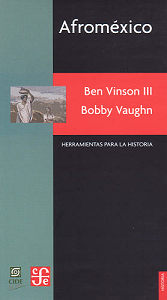
afromexico-coverNew Spain had been conquered by a ludicrously small number of Spaniards. To retain control and in order to begin exploiting the potential riches of the virgin territory they had won, a good supply of laborers was essential. There were not enough locals, so imports of slaves became a high priority.

By 1570, almost 35% of all the mine workers in the largest mines of Zacatecas and neighboring locations were African slaves. [2] Large numbers of slaves were also imported for the sugar plantations and factories in areas along the Gulf coast, such as Veracruz. By the mid-seventeenth century, some 8,000-10,000 blacks were Gulf coast residents. After this time, the slave trade to Mexico gradually diminished.

Miguel Hidalgo, the Independence leader, first demanded an end to slavery in 1810 (the same year that Upper Canada freed all slaves). Slavery was abolished by President Vicente Guerrero on September 15, 1829.

During the succeeding 36 years, prior to the abolition of slavery in the U.S. (1865), some U.S. slaves seized their chance and headed south in search of freedom and opportunity. Recognizing the potential, in 1831, one Mexican senator, Sánchez de Tagle, a signatory of the Act of Independence, called for assistance to be given to any blacks wanting to move south on the grounds that this movement would possibly prevent Mexico being invaded by white Americans. [3] Sánchez de Tagle’s point was that black immigrants would be strong supporters of Mexico since they wouldn’t want to be returned to slavery, and would be preferable to white Americans, who might be seeking an opportunity to annex parts of Mexico for their homeland. Sánchez de Tagle’s fears came to pass. One year after the U.S. annexed the slave-holding Republic of Texas in 1845, it invaded Mexico.

Perhaps as many as 4,000 blacks entered Mexico between 1840 and 1860. At the beginning of 1850, several states enacted a series of land concessions for black immigrants, in order that undeveloped areas with agricultural potential might be settled and farmed.

Even after the abolition of slavery in the U.S., small waves of blacks continued to arrive periodically in Mexico. Many came from the Caribbean after 1870 to help build the growing national railway network. In 1882, some 300 Jamaicans arrived to help build the San Luis Potosí-Tampico line; another 300 Jamaicans made the trip in 1905 to take jobs in mines in the state of Durango. [4] Partially as a response to their own independence struggles, thousands of Cubans came after 1895. They favored the tropical coastal lowlands such as Veracruz, Yucatan and parts of Oaxaca, where the climate and landscapes were more familiar to them than the high interior plateaux of central Mexico.

Mexican historians have largely ignored the in-migration of blacks and their gradual intermarriage and assimilation into Mexican society. For a variety of reasons, they chose to focus instead on either the indigenous peoples, or the mestizos who form the majority of Mexicans today. The pendulum is finally beginning to swing back, as researchers like Charles Henry Rowell, Ben Vinson III and Bobby Vaughn re-evaluate the original sources, and examine the life and culture of the communities where many blacks settled.

Most work about the influence of blacks on modern-day Mexico has focused on the Veracruz area, in particular on the settlements of Coyolillo, Alvarado, Mandinga and Tlacotalpan. 5 On the opposite coast, Bobby Vaughn has spent more than a decade studying the Costa Chica of Oaxaca and Guerrero. [6]

Analysts of Mexican population history emphasize the poor reliability of early estimates and censuses, as well as the complex mixing of races which occurred with time. While the precise figures and dates may vary, most demographers appear to agree with Bobby Vaughn that the black population, which rose rapidly to around 20,000 shortly after the conquest, continued to exceed the Spanish population in New Spain until around 1810.

It is estimated that more than 110,000 black slaves (perhaps even as many as 200,000) were brought to New Spain during colonial times. Happily, their legacy is still with us, and lives on in the language, customs and culture of all these areas.

Sources / Further Reading

1 Matthew Restall. Seven Myths of the Spanish Conquest. (Oxford University Press) 2003

2 Peter J. Bakewell. Silver Mining and Society in Colonial Mexico: Zacatecas, 1546-1700, cited in Afroméxico.

3 Vinson III, Ben & Vaughn, Bobby. Afroméxico. (in Spanish; translation by Clara García Ayluardo) Mexico: CIDE/CFE. 2004. The main source for this column, divided into three parts. Following a joint introduction, Ben Vinson III, Professor of Latin American History at Penn State University, provides a detailed overview of studies connected to blacks in Mexico. Then Bobby Vaughn, who has a doctorate in anthropology from Stanford University, adopts an ethnographic perspective in writing about the Costa Chica of Oaxaca and Guerrero; his short essay includes discussion of the Black Mexico movement. The work concludes with an extensive bibliography of sources relating to Afroméxico.

4 Vinson III, Ben & Vaughn, Bobby. Afroméxico. Mexico: CIDE/CFE. 2004

5 See, for example, the Winter 2004 and Spring 2006 issues of Callaloo (A Journal of African Diaspora Arts and Letters). The Spring 2006 issue, vol 29, #2, pp 397-543, has a series of articles under the general heading of “Africa in Mexico”, including transcriptions of fascinating interviews with such characters as Rodolfo Figueroa Martinez, who relates the history of how several local towns, including San Lorenzo de los Negros (now Yanga) were founded by blacks, and of how a black identity gradually emerged. Other interviewees discuss how they view their color and Afromestizo identity, lamenting the fact that their history has been distorted or largely forgotten. Local food and festival celebrations are also highlighted.

6 Bobby Vaughn’s Black Mexico Home Page, Afro-Mexicans of the Costa Chica, available via MexConnect, provides links to several of his articles including Blacks in Mexico. A Brief Overview.

Original article on MexConnect

Several chapters of Geo-Mexico: the geography and dynamics of modern Mexico discuss population issues, including population growth, distribution and density. Buy your copy today to have a handy reference guide to all major aspects of Mexico’s geography!

Maternal health in southern Mexico

 Mexico's geography in the Press  Comments Off on Maternal health in southern Mexico
Jul 282010
 

A short piece in The Economist entitled “Maternal Health in Mexico: A perilous journey” (26 June 2010) highlights some of the reasons why maternal mortality has remained stubbornly high in southern Mexico, despite a marked improvement in recent years. Since 1990, maternal mortality (death related to childbearing) has fallen by 36% in Mexico as a whole.

Maternal mortality remains alarmingly high

Carrying the future; maternal mortality remains alarmingly high. Photo: Tony Burton. All rights reserved. Click to enlarge.

Any average figure for the whole country disguises enormous regional differences. Rates for the richer inhabitants in the more developed regions in Mexico are comparable to rate in the USA or Canada. However, rates in the impoverished southern states such as Chiapas, Oaxaca and Guerrero are up to 70% higher than the national average.

In the words of the Research for Development blog “In 2005 the maternal mortality rate was 63.4 deaths per 100,000 live births. In the state of Guerrero the rate rose to 128 deaths per 100, 000 live births. Both figures are a long way from Mexico’s commitment under the Millennium Development Goals (MDGs) of 22.3.” Click here to see how well Mexico is doing in meeting other MDGs.

One study found that in the year 2000, only 44.8% of women in Chiapas gave birth with a doctor present; 49.4% did so with midwives, and the remaining 5.8% were attended by family members or give birth alone.

As The Economist article emphasizes, indigenous women are only one-third as likely to survive giving birth as non-indigenous women.

Why is this? What are the key factors preventing lower maternal mortality rates?

The Economist singles out:

  • means of transport – lack of a car means a total reliance on public transport. Public transport is poor in many remote areas
  • poor roads – many rural roads are unpaved, and the terrain in much of Mexico means than travel times are often much longer than might be expected
  • the expense of the hospital tests and medical supplies which can save a mother’s life
  • errors in delivery care or hospital procedures – according to The Economist, “40% of urban maternal deaths are caused by using the wrong medicine, by botched surgery or by other forms of malpractice.”
  • reluctance to see a male doctor (for social or cultural reasons)
  • language issues – many indigenous women do not speak Spanish at all well, if at all, and very few doctors have any knowledge of indigenous languages, so communication is often poor

What is needed to reduce maternal mortality rates? Understandably, The Economist focuses its attention on financial or economic solutions. More money is needed, it argues, for “midwifes and contraceptives.” It reports that increased funds are coming from a variety of sources, including the Spanish government, Carlos Slim (the Mexican entrepreneur who is the world’s richest man) and from the Bill and Melinda Gates Foundation. Between them, they have announced plans to spend 150 million dollars “on health care for the poor in Central America and southern Mexico”.

In addition, the article calls for investment in “infrastructure, health and education”, making the claim that investment in these areas would help the south catch up with the rest of the country.

We consider this analysis of possible remedies for the problem to be incomplete. The political will to continue making investments in health care installations and personnel over the long-term requires, in our opinion, a significant shift in attitudes among the wealthier and more influential sectors of Mexican society.

At present most members of the wealthy elite regard indigenous Mexicans as second class citizens.

At the time of the Chiapas uprising in 1994, for example, a subset of well-educated Mexicans called on the government to resolve the problems the nation faced in southern Mexico once and for all by using maximum force to re-establish complete military control over the area. Fortunately, the government of the day did not follow their advice but opted for alternative approaches such as dialogue.

Mexico’s indigenous peoples are rarely shown on TV or in advertisements. Instead, most firms prefer to picture blond, blue-eyed mestizos. Alongside increased financial investment in the south, a massive shift in public perception is required. For everyone’s sake, let us hope that this can be achieved with a minimum of turmoil.

Mexico’s government has to make tough choices about how far the national budget can stretch, and which things should be prioritized. Decisions are often based on political expediency as much as on the nation’s pressing development needs. Indigenous peoples are not well represented in federal government.

At present, the best-trained physicians and nurses aspire to work in the world class medical facilities in Mexico’s major cities. Health care workers in Mexico’s remote areas are often there only to fulfill the social service requirements for their professional qualification; they perform valuable work, but certainly have no long-term commitment to these regions. In the words of a MacArthur Foundation researcher (quoted in “Evaluation of The MacArthur Foundation’s Work in Mexico to Reduce Maternal Mortality, 2002-2008”) , qualified doctors (residents) “see their work as a big favor they do for the community, rather than understanding that indigenous populations in our country also have a right to health.”

We believe that a change in how society perceives indigenous peoples is a fundamental prerequisite for genuine long-term change, particularly in states such as Chiapas and Oaxaca.

Mexico’s indigenous populations, and the disparities in wealth and opportunity they face, are analyzed in chapters 10 and 29 of Geo-Mexico: the geography and dynamics of modern Mexico. Ask your local or university library to buy a copy today!!

The introduction of sheep caused widespread environmental damage in Mexico

 Books and resources, Excerpts from Geo-Mexico  Comments Off on The introduction of sheep caused widespread environmental damage in Mexico
Jul 032010
 

After the conquest, Spanish settlers introduced numerous Old World species into the New World. The most pernicious introductions were human-borne diseases, which led to the rapid and tragic decimation of the indigenous population. However, most of the introductions were deliberate, made with the intention of increasing the diversity of available food and resources. Among the non-native (exotic) plants and animals introduced were sheep, pigs, chickens, goats, cattle, wheat, barley, figs, grapevines, olives, peaches, quinces, pomegranates, cabbages, lettuces and radishes, as well as many flowers.

The environmental impact of all these introductions was enormous. The introduction of sheep to Mexico is a case in point.

In the Old World, wool had been a major item of trade in Spain for several centuries before the New World was settled. The first conquistadors were quick to recognize the potential that the new territories held for large-scale sheep farming.

Cover of A Plague of SheepThe development of sheep farming and its consequences in one area of central Mexico (the Valle de Mezquital in Hidalgo) was analyzed  by Elinor Melville in A Plague of Sheep. Environmental Consequences of the Conquest of Mexico.

Melville divides the development of sheep farming in the Valle of Mezquital into several distinct phases. Sheep farming took off during Phase I (Expansion; 1530-1565). During this phase, the growth in numbers of sheep in the region was so rapid that it caused the enlightened Viceroy, Luis de Velasco, to became concerned that sheep might threaten Indian land rights and food production. Among the regulations introduced to control sheep farming was a ban on grazing animals within close proximity of any Indian village. At first the Indians did not own any grazing animals, and consequently did not fence their fields, which inadvertently encouraged the Spaniards to treat the landscape as common land.

During Phase II (Consolidation of Pastoralism; 1565-1580), the area used for sheep grazing remained fairly stable, but the numbers of sheep (and therefore grazing density) continued to increase. By the mid-1570s, sheep dominated the regional landscape and the Indians also had flocks. One of the consequences of this was environmental deterioration to the point where by the late 1570s, some farmers did not have adequate year-round access to pastures and introduced the practice of seasonal grazing in which they moved their flocks (often numbering tens of thousands of sheep) from their home farm in central Mexico to seasonal pastures near Lake Chapala.

This practice of grazing on harvested fields or temporary pastures was known as agostadero. This term originally applied to summer (agosto=August) grazing in Spain but was adopted in New Spain for “dry season” grazing, between December and March. So important was this annual movement of sheep that provision was made in 1574 for the opening of special sheep lanes or cañadas along the route, notwithstanding the considerable environmental damage done by the large migrating flocks. As flock sizes peaked, more than 200,000 sheep made the annual migration by 1579.

In the words of historian Francois Chevalier:

By 1579, and doubtless before, more than 200,000 sheep from the Querétaro region covered every September the 300 or 400 kilometers to the green meadows of Lake Chapala and the western part of Michoacán; the following May, they would return to their estancias.

The prime dry season pastures were those bordering the flat, marshy swampland at the eastern end of Lake Chapala. The Jiquilpan district alone supported more than 80,000 sheep each year, as the Geographic Account of Xiquilpan and District (1579) makes clear:

More than eighty thousand sheep come from other parts to pasture seasonally on the edge of this village each year; it is very good land for them and they put on weight very well, since there are some saltpeter deposits around the marsh.

By the end of Phase III (The Final Takeover; 1580-1600), most land had been incorporated into the Spanish land tenure system, the Indian population had declined (mainly due to disease) and the sheep population had also dropped dramatically. Contemporary Spanish accounts reveal that this collapse was attributed to a combination of the killing of too many animals for just their hides by Spaniards, an excessive consumption by Indians of lamb and mutton, and by the depletion of sheep flocks by thieves and wild dogs. Melville’s research, however, suggests that the main reason for the decline was actually environmental degradation, brought on by the excessive numbers of sheep at an earlier time.

The entire process is, in Melville’s view, an excellent example of an “ungulate irruption, compounded by human activity.” The introduction of sheep had placed great pressure on the land. Their numbers had risen rapidly, but then crashed as the carrying capacity of the land was exceeded. The carrying capacity had been reduced as (over)grazing permanently changed the local environmental conditions.

By the 1620s, the serious collapse in sheep numbers in the Valle de Mezquital was over; sheep farming never fully recovered. The landscape had been changed for ever.

Sources / Further reading:

  • Acuña, R. (ed) Relaciones geográficas del siglo XVI: Michoacán. Edición de René Acuña. Volume 9 of Relaciones geográficas del siglo XVI. Mexico City: Universidad Nacional Autónoma de México. 1987
  • Chevalier, F. Land and Society in Colonial Mexico. University of California Press. 1963.
  • Melville, Elinor G. K. A plague of Sheep. Environmental consequences of the conquest of Mexico. Cambridge University Press. 1994.

Click here for the original article on MexConnect.

Mexico’s ecosystems and biodiversity are discussed in chapter 5 of Geo-Mexico: the geography and dynamics of modern Mexico. The concept of carrying capacity is analyzed in chapter 19. Buy your copy today, as a useful reference book!

The Spanish arrive and change lots of place names

 Other  Comments Off on The Spanish arrive and change lots of place names
Jun 072010
 

This is the third in our series of guest blogs by Fatimah Araneta.

Fatimah Araneta grew up in Mexico City. After gaining a Masters in City Planning at Berkeley, California, she opted to eschew city life and direct her energy and attention to living in tune with what’s left of Mother Earth before it all gets paved over and criss-crossed with cabled and non-cabled networks. She lives “off the grid” in the shadow of the volcano she prefers to call Chicnautécatl.

Part 3 – How the Spanish colonization of Mexico contributed to its place names

Santiago Tuxtla coat of arms

Santiago Tuxtla coat of arms

The third layer was bestowed by the Spanish colonizers. Some places received the names of cities in Spain, such as León (in the state of Guanajuato) or Córdoba (in the state of Veracruz). Sometimes the original Nahuatl was maintained but mispronounced so much that the name became corrupted, as in Churubusco, which used to be called Huitzilopochco. Some other times the name of a saint was added to the place name, as in Santiago Tuxtla, Santa Teresa Tiloxtoc or San Miguel Chapultepec.

The choice of the saintly counterpart to an already existing place name was hardly ever a frivolous decision. The different religious orders who set out to convert the indigenous populations to Christianity had their preferences. The Franciscans, for example, relied on Saint Michael to be their champion in the battle against the devils of the New World. Luckily for the evangelizing friars, Saint Michael also happened to possess attributes that made it easy for this religious icon to be accepted by the potential converts.

In the Old World, apparitions of Saint Michael had first taken place on mountaintops (high places near heaven from which he had banished Lucifer) and caves (since he was also in charge of assisting departing souls into the netherworld). Later, he would become involved in miraculous apparitions of springs of water, as in Mont Saint Michel in northern France, and was henceforth increasingly associated with the agricultural cycles of sowing and harvest.

At the same time, a very important figure in the prehispanic pantheon was Tláloc, the rain god, venerated too on mountaintops and at the entrances of caves, since it was believed that mountains were the containers of the weather. It was to Tláloc that one turned to ask for abundant rain for the crops, as well as mercy from the snakes of fire, or lightning bolts, that could inflict so much damage. Images of Tláloc depict him holding a bolt of lightning in one hand, not very differently from how images of Saint Michael show him wielding a flaming sword.

Thus, with this third layer of meaning, a place name in Mexico gives many clues to the past. If  “San Miguel” is part of the name it could be telling us that Franciscan friars had been in charge of the place at one time; that there could have been a cult to Tláloc; that the place was and could still be of hydrological importance; and that it could have been and could still be the focus of religious pilgrimages related to agricultural cycles.

The next part will consider how some Mexican places were rechristened during Mexico’s independent era (post 1821).

Click on the word “placenames” or the “placenames” tag for more articles about Mexico’s place names.

Mar 152023
 

Numerous academic studies have looked at different aspects of the long-established Ajijic retirement community at Lake Chapala. The earliest studies, in the 1970s, looked almost exclusively at the characteristics of the incoming migrants.

Mexican sociologist Francisco Talavera Salgado in Lago Chapala, turismo residencial y campesinado, focused exclusively on the varied impacts of foreign residents on the local Ajijic community.

academic-coversAnthropologist Eleanore Moran Stokes homed in on Ajijic and suggested that the evolution of the village after ‘Discovery’ could be divided into three distinct phases: Founder (1940s to mid 1950s), Expansionary (mid 1950s to mid 1970s) and Established Colony (mid 1970s through the 1980s). During the Founder phase, Ajijic served, in her view, largely as an artists’ colony, whereas later (Expansionary phase) arrivals tended to be members of the affluent and retired middle class; these newer arrivals began to materially change the village by infusing cash into the local economy and starting businesses. They upgraded village homes and created “a new wage labor class in the village.”

In the Established Colony phase vacant houses became increasingly scarce, agricultural land was parceled for vacation and retirement homes, and philanthropic activities became important. Stokes estimated that, by 1979, foreigners occupied about 300 of the 950 houses in the village, but comprised less than 8% of the population.

Geographer David Truly built on Stokes’ framework to develop a matrix of retirement migration behavior. Like Stokes, Truly concluded in 2002 that newer visitors (including retirees), and unlike earlier migrants, had less desire to adapt to the local culture and were more keen on ‘importing a lifestyle’ to the area.

Sociologist Stephen Banks, studied the identity narratives of retirees while he was living in Ajijic in 2002-2003. He concluded that the responses he received during dozens of in-depth interviews revealed:

a struggle to conserve cultural identities in the face of a resistant host culture that has been colonized…. The Lakeside economy is dominated by expatriate consumer demand; indigenous commerce in fishing has disappeared as new employment opportunities opened up in the services sector; local prices for real estate (routinely listed in US dollars), restaurant dining, hotel lodging and most consumer goods are higher than in comparable non-retirement areas; traditional Mexican community life centered around the family has been supplemented, and in some cases supplanted, by expatriate community life centered around public assistance and volunteer programs… and the uniform use of Spanish in public life is displaced by the use of English.”

Some more recent work has focused on the changes in the host community. For example, Marisa Raditsch investigated the impacts of international migrants “based on the perceptions of Mexican people in the receiving context.” Her 2015 study found that these perceptions tended “to be favorable in terms of generating employment and contributing to the community; and unfavorable in terms of rising costs of living and some changes in local culture.”

Even more recently, Mexican researcher Mariana Ceja Bojorge focused squarely on the relationships and interactions between local Ajijitecos and foreigners. She concluded in 2021 that the shift “endangers the acceptance of the presence of the other” and that “Although the presence of foreigners has generated economic well-being in the area, it has also been responsible for the reconfiguration of space, where locals have been forced to leave their territory.”

The details of the extraordinary changes that have taken place in Ajijic since the 1930s are the subject of my 2022 book, Foreign Footprints in Ajijic: Decades of Change in a Mexican Village.

This cover of the book shows a popular restaurant on Ajijic plaza, a perfect example of these changes or reconfiguration of space. The plaza was originally a Mexican space, where locals filled water containers, met friends, gossiped, socialized and bargained at the weekly market. The chapel and all the stores around the plaza were exclusively run by village residents to meet local needs. In those years, if there was a center for foreigners it was the Posada Ajijic bar, restaurant and gardens.

The use of the plaza has changed. After Cine Ajijic opened on the north side of the plaza in 1969, its weekly English-language films actively encouraged foreigners (en masse) to share the same social space as the local community. The supermarket on the south side of the plaza also became a shared space for locals and foreigners, a dual role which continued after the premises became a bank. Stores and restaurants either owned by, or designed to serve, foreigners were established around the plaza. An even stronger foreign focus is evident in the plaza coffee shops which spill over onto what was formerly public space. This has inevitably resulted in a debate about the appropriateness of a private enterprise occupying public space, and whether even paid use, via concessions, is an acceptable tradeoff for the loss of such space. Compromise is needed by all; there will never be any one-size-fits-all solution to any of the issues arising from migration and cultural change.

Full bibliographic details of all the studies mentioned above are included in the bibliography of Foreign Footprints in Ajijic: Decades of Change in a Mexican Village

Geo-Mexico is reader-supported. Purchases made via links on our site may, at no cost to you, earn us an affiliate commission. Learn more.

Mexico and Ireland: a lasting relationship forged by potatoes. Happy St. Patrick’s Day!

 Other  Comments Off on Mexico and Ireland: a lasting relationship forged by potatoes. Happy St. Patrick’s Day!
Mar 152017
 

In honor of St. Patrick’s Day, we offer this short list of references highlighting some of the more significant connections between Ireland and Mexico.

Séamus Ó Fógartaigh in his “Ireland and Mexico“, published in Irish Migration Studies in Latin America by the Society for Irish Latin American Studies (based, curiously, in Switzerland) looks at the early links between Ireland and Mexico, including suggestions that the travels of St. Brendan the Navigator may have inspired Christopher Columbus and that the famous “Plumed Serpent” of Mexican mythology may have originated from the deification of an Irish monk.

Much better known are the later links. During colonial times, several of the Spanish administrators sent to New Spain (now Mexico) were direct descents of Irish exiles to Spain. They include the 63rd and last Spanish Viceroy of New Spain Juan O’Donojú (formerly O’Donoghue) who arrived in the New World shortly before Mexico became Independent in 1821.

A generation later, Irish soldiers who chose to leave (deserted) the US army formed the backbone of Mexico’s St. Patrick’s Battalion (Batallón San Patricio) which fought the invading Americans in 1846-48. They are especially remembered for their bravery in the Battle of Churubusco (in Mexico City) in 1847. Their story is well remembered by Mexicans today, their exploits commemorated every year at a ceremony in Mexico City, and the basis of several books and the movie One Man’s Hero. The single, best account is that by Michael Hogan in The Irish Soldiers of Mexico. For a summary account, try “The St. Patricio Battalion, The Irish Soldiers of Mexico” by Jaime Fogarty, published in UNAM’s Voices of Mexico magazine, April-June, 2000.

San Patricio Melaque (Google Earth)

San Patricio Melaque (Google Earth)

On the Jalisco coast, the small town of San Patricio Melaque (around the bay from Barra de Navidad and the Isla de Navidad tourist development) holds an annual fiesta that celebrates both the town’s patron saint and the achievements of the Irish soldiers. Nine days of activity (church services, fireworks, parades, bullfights, fairground games) come to a climax on 17 March. (It is sometimes claimed that San Patricio Melaque is the only settlement named San Patricio in Mexico, but that is not quite true, since there are at least three others: two tiny hamlets called San Patricio, relatively close to Cd. Victoria in Tamaulipas, and one named San Patricio de la Mesa in the mountains east of Hermosillo in Sonora.)

In the twentieth century, Álvaro Obregón (family name O’Brien) was President of Mexico from 1920 to 1924. (We will take a critical look at his relationship with the indigenous Yaqui Indians of Sonora in a later post). The city of Ciudad Obregón in Sonora is named in his honor. Artists of Irish descent also impacted Mexico’s national life. They included architect, painter and muralist Juan O’Gorman (1905-1982), responsible for the monumental mosaic that adorns the walls of the National University (UNAM) Library in Mexico City, and a striking, colorful mural in Pátzcuaro that depicts an erupting volcano; this mural was completed just one year before the unexpected eruption nearby of Paricutín Volcano.

Today, according to Wikipedia, there are between 300,000 and 600,000 people of Irish descent living in Mexico, mostly in either northern Mexico or Mexico City.

Dr. Michael Hogan has done far more than most to publicize the links between Ireland and Mexico.

Most of the links we’ve described might never have happened if Mexico had not sent an unwanted export to Ireland in the middle of the nineteenth century. The census of 1841 in Ireland recorded a population of about 8 million. The staple Irish food at that time was the humble potato and Ireland’s rapid population growth during the early part of the nineteenth century was based on the so-called “potato economy”.  Ireland was bursting at the seams in 1841, but just a decade later, after the potato famine, the population had fallen to 6.5 million. The cause of the Irish potato famine was a water mold (Phytophthora infestans) that originated in Mexico and crossed the Atlantic in the 1840s, reaching Europe in 1845 before rapidly spreading across the continent to reach Ireland.

If a Mexican water mold had not provoked the Irish potato famine, maybe there would have been no settlements named San Patricio in Mexico today, and no cause to celebrate St. Patrick’s Day in Mexico! Wherever you may be, have a very Happy St. Patrick’s Day!

Related links:

Is Jalisco the most “Mexican” state?

 Other  Comments Off on Is Jalisco the most “Mexican” state?
Jan 092017
 

Tapatíos (residents of Guadalajara) and Jaliscienses (residents of Jalisco) often brag that they live in the most “Mexican” area of the country. Are these boasts truthful? This is not an easy question to answer. It involves looking at a broad range of evidence.

Jalisco’s climate and natural ecosystems are very diverse like the country as a whole. It is the only state with all of the country’s five principal natural ecosystems (tropical evergreen forest, tropical deciduous and thorn forest, temperate forest, grassland and mesquite-grassland, and arid and semi-arid scrubland) [Geo-Mexico, page 31]. Furthermore, Jalisco has Lake Chapala, the country’s largest natural lake as well as the Colima Volcano, one of the most active in the country. Certainly from a physical geography perspective Jalisco appears the most representative of Mexico as a whole. (For other natural wonders of Jalisco see John Pint’s website: http://ranchopint.com).

Map of Jalisco state

Map of Jalisco. Copyright 2010 Tony Burton. All rights reserved.

Jalisco’s socio-economic characteristics are also representative of Mexico. Its population has an average growth rate and is distributed among a very large city, secondary and smaller cities, extensive farming communities and isolated indigenous areas. While its adjusted per person income is just below the national average, its human development index (composed of infant mortality rate, adult literacy, school enrollment ratio, and adjusted average personal income) is slightly above. Jalisco is similar to Mexico regarding the main economic sectors of agriculture, industry and services, including tourism.

From a tourism perspective, Jalisco includes everything Mexico has to offer: fantastic beach resorts, urban cultural and artistic attractions, natural wonders, significant indigenous areas and impressive archeological sites. On the other hand, Jalisco is not representative in that it is the leading agricultural state (first in production of corn, beef, pork, poultry, milk and eggs). It is also more predominantly Catholic and politically more conservative than Mexico as a whole. Aside from these two exceptions, Jalisco is quite representative from a socio-economic perspective.

Perhaps cultural aspects are the most important in determining the most “Mexican” of the 32 states. Here Jalisco really stands out. It is the birthplace of such stereotypical Mexican cultural characteristics as charrería (Mexican horsemanship), jarabe tapatío (Mexican hat dance), mariachi music, and tequila, the national drink.

In conclusion, the available evidence appears to support the boasts of some Tapatíos and Jaliscienses that they live in the “most Mexican” area of the country.

Many aspects of Mexico’s culture feature in Geo-Mexico: the geography and dynamics of modern Mexico, a handy reference guide to all aspects of Mexico’s geography. If you have enjoyed this post, consider gifting a copy of Geo-Mexico to someone you know.

The geography of Mexico City: index page

 Index page  Comments Off on The geography of Mexico City: index page
Sep 052016
 

This index page has links to our more important posts about Mexico City. Other index pages include:

Administrative

Mexico City background / physical geography / hazards

Water supply / drainage

Sewers / Drainage

Aztecs – Food supply

History / Urban growth / Urban morphology / Housing

Megalopolis?

Mexico City air quality in 1980 (Photo: Tony Burton)

Mexico City air quality in 1980 (Photo: Tony Burton)

Traffic, taxis and air pollution

Metro/subway system

Sustainable Transport / Cable Cars

Airport

Urban revitalization

Other

Map of Mexico City urban system:

Map of Mexico City urban system

Map of Mexico City urban system. Click to enlarge. (Geo-Mexico Fig 23.1; all rights reserved).

Spatial growth of Mexico City Metropolitan Area:

Mexico City Metropolitan Area (Geo-Mexico Fig 22.2; all rights reserved)

Spatial growth of Mexico City Metropolitan Area (Geo-Mexico Fig 22.2; all rights reserved)

Locations in Valley of Mexico with high incidence of ground cracks:

Mexico City cracks map

Locations in Valley of Mexico with high incidence of ground cracks. Cartography: Tony Burton; all rights reserved.

General posts about Mexico’s urban geography

Aug 152016
 

Avid Geo-Mexico readers will know that we included a few paragraphs about the Happy Planet Index in our 2010 book, which we later quoted in this 2013 post, Mexico and the Happy Planet Index.

The latest (2016) Happy Planet Index (HPI), which uses slightly modified criteria, shows that Mexico has risen to 2nd place in the world rankings, behind Costa Rica, but ahead of Colombia, Vanuatu and Vietnam and well ahead of the U.S. (#108) and Canada (#85).

The Happy Planet Index is a compound index that combines four measures:

  • life expectancy
  • well being (life satisfaction)
  • ecological footprint
  • inequality

The HPI looked at data for 140 countries. For life expectancy, Mexico ranked #39, for well being #11, for ecological footprint #77 and for inequality #60.

Global pattern of ecological footprint. Source: HPI report, 2016.

Global pattern of ecological footprint. Source: HPI report, 2016.

The world map for ecological footprint shows the global pattern. The colors show three categories for ecological footprints, those below 1.7, those between 1.7 and 3.5 and those that exceed 3.5, where the numbers are global hectares (gha) per person.

These two sections from the Happy Planet Index country report for Mexico are a useful snapshot of where Mexico stands right now:

What’s working well in Mexico?

In recent years, massive steps have been taken to improve the health of the population of Mexico – notably achieving universal health coverage in 2012, making essential health services available to the entire population.

In 2014, a tax was imposed on sugary drinks with the express aim of tackling of obesity – this despite strong corporate opposition. The tax had already led to a 12% decrease in the consumption of such drinks by the end of the year.

Environmental sustainability is receiving growing political attention, and was included as one of five key pillars in Mexico’s National Development Plan for 2007–12. Mexico was the second country in the world to incorporate long-term climate targets into national legislation, and is taking important steps to conserve its forests and protect its rich biodiversity.

What could be improved?

Significant challenges remain for Mexico: economic inequality is a massive problem with a considerable gap between the richest and poorest – the top 20% of the population earns more than thirteen times as much as the bottom 20% of the population.

Mexico’s poverty rates are particularly high among indigenous people. Amnesty International has  highlighted Mexico’s human rights violations, especially relating to irregular migrants. On top of these issues, the importance of the oil industry to Mexico’s economy complicates its environmental efforts.

Mexico recently reached cross-party agreement on the Pacto por Mexico, a pact of 95 initiatives aiming to tackle some of these issues – an important step for the country’s future.

The HPI attempts to quantify an alternative vision of progress where people strive for happy and healthy lives alongside ecological efficiency in how they use resources. Mexico may have a high happiness index, but (like the rest of the world) it still has an awful long way to go to ensure a sustainable future for our grandchildren.

Related posts:
Maps of Mexico on geo-mexico.com

 Index page, Maps  Comments Off on Maps of Mexico on geo-mexico.com
Dec 012015
 

This page lists some of the many maps on Geo-Mexico.com.

Want to use a map? All these maps [except those marked  (*)] are original Geo-Mexico.com maps. The use of any of Geo-Mexico’s maps for educational purposes is fine, provided credit is given to  Geo-Mexico.com. For commercial use (including business presentations, newsletters, magazines, books, TV), please contact us with details of your project via the link or the Contact Us form.

General / Educational:

Physical geography

Hazards:

Population

Economy

Regional and city maps

Crime:

History:

Other:

Mapping exercises:

 Tagged with:

The geography of the Spanish language: how important is Spanish around the world?

 Books and resources, Other  Comments Off on The geography of the Spanish language: how important is Spanish around the world?
Aug 242015
 

The Index of Human Development ranks Spanish as the second most important language on earth, behind English but ahead of Mandarin.

Spanish is the third most widely used language on the internet (graph), although less than 8% of total internet traffic takes place in Spanish. Spanish is the second most used language on Facebook, a long way behind English but well ahead of Portuguese.

Languages used on the Internet (2015). Source: Internet World Stats

Languages used on the Internet (2015). Source: Internet World Stats

According to El español, una lengua viva – Spanish, a living language, a report from the Instituto Cervantes in Spain (which promotes the Spanish language abroad via language classes and cultural events) there are about 559 million Spanish speakers worldwide. This figure includes 470 million native speakers and an additional 89 million who have some command of the language.

While Mexico remains the world’s largest Spanish-speaking country, with about 121 million Spanish speakers, second place belongs to the USA, followed by Colombia. The USA has an estimated 41 million native speakers of Spanish plus 11 million who are bilingual; Colombia has 48 million Spanish-speakers.

In terms of economic importance, the report’s authors calculate that Spanish speakers contribute 9.2% of the world’s GDP. About two-thirds of Spanish-linked GDP is generated in North America (USA, Canada and Mexico) and the European Union, while Latin America (excluding Mexico) accounts for 22%.

The main concentrations of Spanish speakers in the USA are in the states of New Mexico (47% of the population), California and Texas (both 38%), and Arizona (30%). 18% of New Yorkers speak Spanish and, somewhat surprisingly, more than 6% of Alaskans are also Spanish speakers. Interestingly, the US Census Office estimates that by 2050, the USA will have 138 million Spanish speakers and could then overtake Mexico as the largest Spanish-speaking nation in the world. This assumes that current predictions for Mexico’s population increase over the next 35 years hold true.

Want to learn more?

Related posts: