Sep 282015
 

The gradual devaluation of Mexico’s Magic Towns (Pueblos Mágicos) program, reported here in earlier posts, continues with the recent addition of 28 new Magic Towns to the list, bringing the total number to 111.

Magic Towns

At the Second Annual Fair of Magic Towns, held in Puebla recently, the Federal Tourism Secretary Enrique de la Madrid announced that 28 of the 180 applicant towns had been accepted into the promotional program. The designation is supposedly reserved for “cities, towns and villages with special symbolic features, legends and history, and opportunities in tourism”, but several existing Magic Towns have very little indeed to offer tourists, and little cultural or historical significance. The same can be said for several of the latest group of 28 Magic Towns.

Towns, by state (September 2015) [corrected]

Mexico’s Magic Towns, by state (September 2015) [corrected]

Towns in the program are eligible for federal grants towards maintenance, rebuilding historic centers, improving infrastructure, installing underground utilities, developing tourism products, training and other projects. According to Magic Town proponents, the program increases visitor numbers and income by between 20 and 30%, though it is very hard to see where such positive numbers come from.

The latest 28 additions to the Magic Towns program are:

  • San José de Casas (Aguascalientes)
  • Candela and Guerrero (Coahuila)
  • Palenque (Chiapas)
  • Aculco, Ixtapan de la Sal [incorrectly given as Ixtapa de la Sal in the press release], Teotihuacán, San Martín de las Pirámides and Villa de Carbón (State of Mexico – Estado de México)
  • Tecozahutla (Hidalgo)
  • Mascota and Talpa de Allende (Jalisco)
  • Sayulita, (Nayarit)
  • Linares (Nuevo León)
  • Huautla de Jiménez, Mazunte, San Pablo Villa Mitla and San Pedro y San Pablo (Oaxaca)
  • Atlixco and Huauchinango (Puebla)
  • Isla Mujeres and Tulum (Quintana Roo)
  • San Joaquín (Querétaro)
  • Mocorito (Sinaloa)
  • Tlaxco (Tlaxcala)
  • Coscomatepec, Orizaba and Zozocolco (Veracruz)

On a positive note, it means that my Western Mexico, A Traveler’s Treasury (2013) now has descriptions and details of no fewer than 18 Magic Towns, rather than the 15 previously included!

Related posts:

Sep 102015
 

We have seen numerous examples in previous posts of Mexico’s astonishingly diverse attractions for international tourism. Having succeeded in attracting mass tourism (e.g. Cancún, Ixtapa, Huatulco), Mexico has sought to diversify its tourism appeal by developing niche markets for visitors with special interests, such as cuisine, adventure tourism, historic sites and health-related holidays.

Mexico’s tourism development agency, FONATUR, recently announced it is seeking help from Spain’s leading cultural tourism firm, Paradores de Turismo, to establish a network of Paradores (luxury hotels in historic buildings) in Mexico. Frequent travelers to Spain will be more than familiar with the Paradores system there which offers visitors the chance to stay in some unique historical buildings without sacrificing too many creature comforts.

Route followed by Cortés, 1519-1521. Credit: Wikimedia Commons.

Route followed by Cortés, 1519-1521. Credit: Wikimedia Commons. Click to enlarge.

In Mexico, a “History Tourism Plan” is being developed by FONATUR and the Federación de Haciendas, Estancias y Hoteles Históricos de México. In the first stage, an inventory will be compiled of the best existing haciendas, monasteries and other historic buildings that already are, or could be converted to, hotels. At the same time, experts will be discussing which “routes” offer the best combinations and provide most interest to tourists. Routes will be developed to highlight specific themes.

The first route to be proposed is The Route of Cortés, linking properties in five states: Veracruz, Puebla, Tlaxcala, State of Mexico and the Federal District (see map). This is a timely idea given that the 500th Anniversary of the arrival of Cortés and his journey to central Mexico comes in 2019.

Related posts:

Mexico’s tourism development policies: a model for the world?

 Mexico's geography in the Press  Comments Off on Mexico’s tourism development policies: a model for the world?
Aug 272015
 

Mexico welcomed a record number of tourist last year: 29.1 million visitors, a 20.5% increase over 2013. The number of tourists is projected to grow 8% this year. Most tourists visiting Mexico come from the U.S., followed by Canada, U.K., Colombia and Brazil. During the first six months of 2015, the average expenditure/tourist was 865 dollars.

Mexico is the top international destination for U.S. tourists and according to U.S. Commerce Department data, visits to Mexico by U.S. tourists rose 24% in 2014 to a record 25.9 million, despite U.S. travel warnings relating to parts of the country. Figures from the Mexican side of the border suggest a more modest, though still substantial, increase of 11.8% in U.S. tourists entering the country. The differences in the figures reflect slight differences in definitions and methodology.

Just how did Mexico achieve its tourism success? The answer appears to be a combination of its fortuitous proximity to the USA allied with some smart policy decisions. This helps to explain why the Organisation for Economic Cooperation and Development (OECD) has chosen Mexico as the basis for developing a transferable model to demonstrate the potential of tourism in international development. The in-depth study, to be published next year, will focus on the economic and political aspects of international tourism.

Related posts:

Repainting the walls of Palmitas in Pachuca leads to reduced crime

 Mexico's geography in the Press  Comments Off on Repainting the walls of Palmitas in Pachuca leads to reduced crime
Jul 302015
 

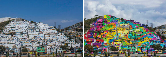
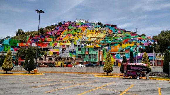
Palmitas is a small, densely-populated neighborhood in the city of Pachuca, the capital of the state of Hidalgo in central Mexico. It has a reputation for higher than average levels of deprivation, crime and violence.

An innovative social development project, based on artistic transformation, has turned Palmitas over the past few months into a rainbow-hued, quasi-kaleidoscopic, example of urban renewal.

palmitas-foto-jorge-gonzalez

Palmitas, 2015. Photo credit: Jorge González / UNIÓN Hidalgo

The project involved four main players: an art collective (“Germen Crew”), the city government, Comex (a major national paint manufacturer) and a youth organization that was previously better known for its graffiti art.

The youths joined “Germen Crew” and painted 209 houses, some 20,000 square meters of facade in total, into a single rainbow mural. The specialized materials used, supplied by Comex, have provided maximum long-term protection for the dwellings while turning the streets into ribbons of color. The greatest challenge was that many of the exterior walls were in a very rough shape, and some had never been properly finished or protected.

The “macro mural” has been called the “world’s largest” in some news reports. This title is hotly disputed; other contenders include a mural in Berlin and the Pueblo Levee Project in Colorado.

According to streetartnews, the community involvement in this project from start to finish, led to positive effects on 452 families (1808 people), and a dramatic fall in youth violence, to the point of almost eradicating it.

All the homes were first painted white to symbolize the unity of the community, that all community members are equal, and that all members of the community would benefit from the urban renewal. This pair of photos shows before and after images of Palmitas:

crew-germen-graffiti-town-mural-palmitas

Alongside the months of paintings, numerous community events were held to foment participation and a sense of local ownership of the project.

This short video on Youtube (Spanish) describes the project:

The colorful Palmitas project is an unusual and interesting example of urban improvement, urban renewal or urban regeneration.

Comex has said that it will support similar urban renewal projects elsewhere in Mexico that beautify the local settings and help improve people’s lives, so please report back if you find a similar project happening in your neighborhood.

Related posts:

The Trans-Isthmus mega-project

 Mexico's geography in the Press  Comments Off on The Trans-Isthmus mega-project
Jul 272015
 

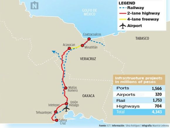
A huge industrial development plan looks set to get underway shortly in the narrow Isthmus of Tehuantepec in southern Mexico. The low-lying Isthmus of Tehuantepec separates the Chiapas Highlands and the low Yucatán Peninsula from the rest of Mexico. The Isthmus was once considered as an alternative location to Panama for a trans-continental canal.

During Mexico’s internal Reform War (1858‑60), between the liberals, led by Benito Juárez, and the conservatives, both sides encountered serious financial problems. At one point in this war, the liberals accepted an offer from the USA to receive four million pesos in exchange for the USA having the “right of traffic” across the Isthmus of Tehuantepec “in perpetuity”. Fortunately, this treaty was never ratified by the US Senate.

Proyecto-Transistmico

In recent years, the Tehuantepec area has received massive investments in wind power, with several major wind farms already operational and more on the drawing board. The latest plans will build on those investments to provide upgraded infrastructure meeting the preconditions for industrial development.

The 300 million dollars allocated to the first phase of the Trans-Isthmus Project will improve railroads, highways, airports, and the ports of Coatzacoalcos on the Gulf Coast and Salina Cruz on the Pacific Coast (see map).

During the second phase, private sector financing will add industrial development areas, which should boost the area’s contribution to national GDP from 2% to 4.5%, and raise the regional GDP/person to $10,000 a year, close to the national average.

The federal government has designated this region as a special economic zone, offering several fiscal incentives to new enterprises. Chinese investors have already expressed interest in building a 200-million-dollar steel manufacturing plant in the isthmus, utilizing nearby iron ore reserves to produce 3 million tons of steel a year.

Posts related to the same general area of Mexico:

Latest additions to Mexico’s Protected Natural Areas

 Mexico's geography in the Press, Updates to Geo-Mexico  Comments Off on Latest additions to Mexico’s Protected Natural Areas
Jul 202015
 

Alejandro del Mazo Maza, head of Mexico’s Commission for Protected Natural Areas (Áreas Naturales Protegidas), says that the formal decrees for seven additional PNAs (Protected Natural Areas) will be published shortly. In some cases, the decrees apply to areas whose status as protected areas was first announced months or even years ago.

The seven new additions are in the north and northwest regions of the country:

  • the Marismas Nacionales biosphere reserve in Sonora
  • Monte Mojino (protected area of flora and fauna), Sonora
  • the Sierra de Tamaulipas biosphere reserve
  • the Playa Boca de Apiza sanctuary in Colima
  • the Islas del Pacífico of Baja California reserve
  • the Semiarid Desert reserve of Zacatecas
  • the Sierras la Giganta y Guadalupe reserve in Baja California Sur

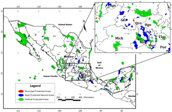
Mexico currently has 177 PNAs (in various categories), and the new additions bring that total to 184.

In addition, preparatory studies are underway to establish two additional biosphere reserves, for the Mexican Caribbean and the Gulf of California (Sea of Cortés).

Mexico's Protected Areas (Gallina, 2012)

Mexico’s Protected Areas (Gallina, 2012)

The Commission of PNAs is working hard to complete formal management plans for every PNA – environmental, social and economic issues. At present, only 97 of the 177 PNAs have such plans in place, with the latest plans published only weeks ago for:

For example, the management program for the whale shark reserve authorizes a maximum of 160 whale-watching boats in an effort to ensure sustainability.

Source of Map:

Sonia Gallina, 2012. “Is Sustainablity Possible in Protected Areas in Mexico? Deer as an Example of a Renewable Resource.” Sustainability 2012, 4 (10), 2366-2376

Related posts:

Recent eruptions of Colima Volcano, el Volcán de Colima

 Mexico's geography in the Press  Comments Off on Recent eruptions of Colima Volcano, el Volcán de Colima
Jul 122015
 

Colima Volcano (aka el Volcán de Colima or el Volcán de Fuego) continues to erupt, displaying its fiery temper by throwing massive plumes of ash and smoke several kilometers into the air. One recent eruption caused a plume of ash seven kilometers high.


Following the eruptions of 10 and 11 July 2015 (see video clip from Webcams de México), a state of emergency has been declared by the state of Colima in 5 municipalities: Colima, Comala, Coquimatlán, Cuauhtémoc and Villa de Álvarez. This enables rapid access to state and federal funds in preparing to cope with any potential disaster.

A precautionary evacuation has been ordered of all communities within a 12-kilometer radius of the volcano’s crater. The 50-60 residents of the closest community to the volcano, La Yerbabuena, live barely eight kilometers (five miles) away from the crater. Five centimeters (two inches) of ash fell on La Yerbabuena in the past few days.

Authorities are concerned that heavy summer rains could generate dangerous and very fast-moving lahars. Lahars are mudflows of volcanic ash, pumice and rocks; they can travel at velocities of up to 100 km/h and move huge boulders and objects as large as houses.

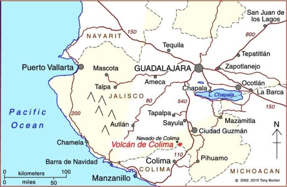
Where is Colima Volcano (Volcán de Colima)?

Location of Colima Volcano

Location of Colima Volcano (Volcán de Colima). Credit: Tony Burton / Geo-Mexico

The volcano is one of the westernmost volcanoes in Mexico’s Volcanic Axis, which straddles the country from west to east. Colima Volcano’s summit is only 8 km (5 miles) from the inactive Nevado of Colima volcano, Mexico’s sixth-highest peak, which rises 4260 m (13,976 ft) above sea level. (Lovers of geographical trivia should note that, despite their names, the summits of both volcanoes are actually located in the state of Jalisco, not in the state of Colima.)

Colima Volcano is considered one of Mexico’s most dangerous volcanoes. Numerous villages in its shadow keep a wary eye on its level of activity, and emergency evacuations have become a regular event over the past fifty years.

How high is Colima Volcano?

The elevation of Colima Volcano is officially given as 3820 m (12,533 ft) above sea level. In the past 400 years, it has been the most active volcano in Mexico, having erupted at least 30 times since 1576. Recent activity means that this exact height may no longer be correct.

The eruption of Colima Volcano on 21 January 2015, shown in this short video, is typical of recent activity.

How often does it erupt?

Historically, the eruptions of the volcano have fallen into a definite cyclical pattern with periods of activity, each lasting about 50 years, interspersed with periods of dormancy. The first cycle of activity (after the Spanish arrived in Mexico) was between 1576 and 1611. Major eruptions occurred in 1680 and 1690, and further complete cycles occurred between 1749 and 1818, and from 1869 to 1913.

The current eruption cycle

Most geologists agree that current activity is part of the fifth cycle, which began in 1961. Judging by past performance, we should be nearing the end of this cycle, though volcanoes can be extremely unpredictable, so don’t bet your house on this happening within the next decade.

Activity has intensified in the past couple of years. In early 2013, we reported that Colima Volcano had erupted, destroying a lava dome first created in 2007 and later that year we looked at how Popocatapetl Volcano and Colima Volcano continued to erupt. At that time, experts monitoring the volcano were reporting up to 200 eruptive events a day, with numerous minor emissions of lava. Colima Volcano has been exhibiting four distinct types of volcanic activity in recent years:

  • lava dome growth
  • explosive eruptions
  • flank collapse
  • lava flows.

In early 2015, activity began to intensify, with several spectacular eruptions, sending ash and dust up to 8 or 9 kilometers (5-6 miles) into the air. Ash fell on towns up to 25 kilometers (15 miles) away from the volcano, in locations including Tuxpan, Zapotiltic and Ciudad Guzmán, but with no loss of life, or significant property damage.

The volcano can be viewed via this permanent fixed webcam operated by Webcams de Mexico. Below the main image on that site are links to 1-minute time-condensed videos showing the past 24 hours of activity.

Three maps (PDF format, Spanish-language keys and text) showing the areas likely to be affected by the volcanic hazards associated with Colima Volcanocan be found via this webpage of Mexico’s National Center for Disaster Prevention (Centro Nacional de Prevención de Desastres, CENAPRED). :

The area around the Colima Volcano is described in more detail in chapter 15 of my Western Mexico, a Traveler’s Treasury (4th edition; Sombrero Books, 2013).

Related posts:

Ground-breaking mapping of Mexico’s drug war

 Mexico's geography in the Press  Comments Off on Ground-breaking mapping of Mexico’s drug war
Jul 022015
 

During the 2006-2012 federal administration, it was possible to map the incidence of crime across the country, with data readily available at both the state and the municipal level. The current administration of President Enrique Peña Nieto has diverted press attention away from the drugs-related violence, arguing that press coverage only serves to give more publicity to the bad guys. Unfortunately, that decision means that it has now become next to impossible to get regularly updated data for, or be able to map, the patterns of criminal activity.

This is one of the inevitable caveats that limits the future application of the ground-breaking methods (using data from 2007 to 2011), developed by Jesús Espinal, a quantitative analyst at the National Institute of Genomic Medicine in Mexico City,and Hernán Larralde, statistical physicist at the National University (UNAM). Their work is described in “Mapping Mexico’s deadly drug war“, in Science magazine.

Mapping by Jesús Espinal Enríquez in Science magazine. Click to enlarge.

Mapping by Jesús Espinal Enríquez in Science magazine. Click to enlarge.

Essentially, they took official data for the location and date of all drug-related homicides in Mexico. They built a complex month-by-month network looking for temporal correlations in the homicide numbers between different cities. “If cities shared a death rate higher than 70 casualties per 100,000 inhabitants in a year and were less than 200 kilometers apart, Larralde and Espinal linked them together on their map to tease out broader geographical patterns.”

The results (summarized by the maps) are interesting. They show the rapid spatial spread of violence during the administration of Felipe Calderón as his government waged its war on drug cartels. The map for 2011 suggests that violence may have been finally becoming less widespread and becoming more focused on a relatively limited number of places.

Two major points are worth emphasizing. First (and as we have repeatedly pointed out in previous posts on this subject), the incidence of violent crime, including homicides, is certainly not similar across the entire country. Some states have much higher homicide rates than others; some municipalities have much higher rates than others. Some parts of the country, including several important tourist areas, have witnessed little or no drug-related violence.

Second, there is no evidence that the spread of violence between 2007 and 2011 occurred by continuous “contagious” diffusion (i.e. that it gradually spread from a single central point or a limited number of central points). The work of these authors supports the contention that the drugs-related activity in Mexico could, and did, increase simultaneously in cities far apart. This is only suggesting a coincidence in timing, and is certainly not proof of any causal connection. A small number of cities, such as Ciudad Juárez, Acapulco, Culiacán, Monterrey, Tampico and
Tijuana, appear as nodes in the network.

This approach may offer some help to policy makers as they consider alternative approaches to combating drugs-related violence, but, as the article makes clear, it does not necessarily mean that the best policy is to attack the cartels in the central hub cities. Aiming at the heart of a major cartel might reduce violence for a time, but could also lead to the formation of numerous smaller splinter groups with different ideals and methods. For example, after the leadership of the Gulf Cartel was dismantled in 2010, the cartel’s former enforcing arm, the Zetas took over, introducing a wave of more extreme violence.

Related posts:

Good news: tax on sugary drinks in Mexico is decreasing consumption

 Mexico's geography in the Press  Comments Off on Good news: tax on sugary drinks in Mexico is decreasing consumption
Jun 252015
 

On 1 January 2014, the Mexican government implemented a 10% tax on refrescos (aka sodas, pop, carbonated drinks) and other sugar sweetened drinks, raising the price by 1 peso (about 7 cents US) per liter, in an attempt to help curb the nation’s obesity problem. The tax became law despite heavy lobbying against it by the beverage industry. An 8% tax was also added to unhealthy snacks like potato chips and cookies.

Now preliminary results of a study (not yet peer reviewed) by the Mexican National Institute of Public Health and the Carolina Population Center at the University of North Carolina, show purchases of sugary beverages dropped 6% on average across 2014, and by as much as 12% in the last part of the year. The study analyzed consumption in 53 Mexican cities, and adjusted for other factors like the small downward trend in consumption of carbonated drinks in recent years. The effect was greatest in lower income households where purchases were cut by 9% over the year and by 17% in the later months. Moreover, the researchers claim that Mexicans drank more water after the refresco tax came into effect.

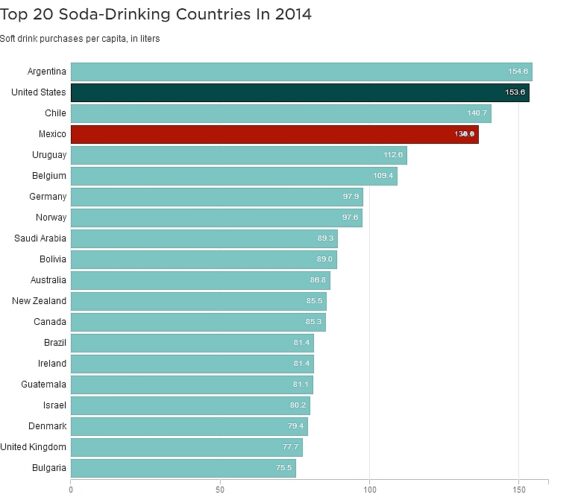
soft-drinks-2014Mexicans’ consumption of carbonated drinks per capita is the fourth highest in the world (behind Argentina, USA and Chile), with the average Mexican drinking the equivalent of 136 liters of Coca-Cola a year. Government revenues from the new tax totaled 18 billion pesos (US$1.3 billion) in 2014. The National Health Alliance, a Mexican public interest coalition, is now calling for the tax to increase to 20%, and for the abolition of tax on bottled water sold in containers of under 10 liters, to make it cheaper than sugary drinks. The Alliance is also pressuring the government to follow through on its promise to use the tax revenues raised to fund programs to prevent obesity and its associated diseases – for example, making free, clean drinking water available in schools that don’t currently have it.

In its March 2015 report on Carbonates in Mexico, Euromonitor International, reporting from an industry perspective, concludes:

(The tax) is one of the many new strategies that the Mexican government is implementing to fight the rising obesity and diabetes II rates after becoming the leading country for obese or overweight citizens globally in 2013…The most affected carbonated products are those sold in big sizes where consumers are more aware of the increased cost. Some leading brands have their stronger position among the biggest sizes of the market, and these brands have seen a greater impact in their volume sales. Amongst carbonates, Coca-Cola (de México SA de CV) holds a 68% total volume share, followed by its closest competitor Pepsi-Cola (Mexicana SA de CV), at 16% .

Carbonates is expected to keep on struggling with volume growth in Mexico due to consumers wanting healthier options, the increasing trend of having RTD teas and increasing trend of fruit-flavoured beverages instead of carbonates. Additionally, government actions have strongly impacted carbonates’ consumption.”

Related posts:

The River Santiago and the Juanacatlan Falls: from the “Niagara of Mexico” to the “Silent River”

 Books and resources, Mexico's geography in the Press  Comments Off on The River Santiago and the Juanacatlan Falls: from the “Niagara of Mexico” to the “Silent River”
Jun 112015
 

In summer 1987, while living in Guadalajara, I entertained a fellow UK geographer, who arrived with a long list of places he wanted to visit. Over the next few weeks, we ticked them off one by one. Near the end of his visit, he asked why I hadn’t yet taken him to see the famous Juanacatlán Falls, the “Niagara of Mexico”, despite them being in his “top ten” places to see. “OK”, I said, “let’s go!”

Traffic was heavy and as we drove across Guadalajara, I could see his impatience building. Finally, he asked me, “Where are they? How close are we?” I replied that we were “fairly close” but that I was absolutely certain that he would recognize them before they came into sight. A few minutes later and he screwed up his nose and said, “Ughh. What’s that smell?” “See?”, I said triumphantly, “I knew you’d recognize them before you saw them!”

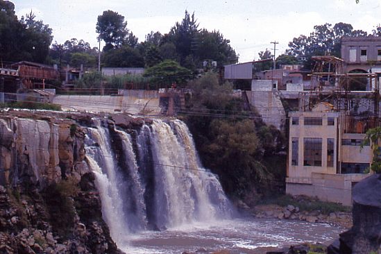
Juanacatlán Falls in 1989. Photo: Tony Burton. All rights reserved.

Juanacatlán Falls in 1989. Photo: Tony Burton. All rights reserved.

Even thirty years ago, long before NAFTA, the Juanacatlán Falls were a sorry sight (and source of a worse smell). Since then, and since NAFTA, they have only become worse. These once-majestic falls, the first Mexican landscape on a postage stamp back in 1899, have been reduced to a trickle of foul-smelling effluent. At the start of the twentieth century, the falls provided hydro-electric power for Guadalajara and turned the wheels of a cotton and woolen mill, the ruins of which now stand to one side.

A recent piece of investigative journalism about the River Santiago, the river which created these waterfalls, makes for disturbing reading. It provides plenty of evidence that the rapid increase in factories along the river, mainly post-NAFTA, may have provided 50,000 new jobs, but has also led to worsening water quality to the point where exposure to the river presents a serious public health risk.

In “River of Death“, Steve Fisher lays bare the terrible reality faced by those living and working close to the river. This is a harrowing tale, with heart-rending testimony from several local residents. On a positive note, the related video, Fusion Investigates: Silent River (below) describes how Sofía Enciso and her family have defied death threats and are determined to confront the factories responsible, while demanding that the relevant authorities take action to enforce federal water quality regulations, and start to clean up the river.

Perhaps the most telling single statistic is that precisely zero companies were fined for failing to comply with water discharge regulations between 2005 and 2011.

In the video, the mayor of El Salto, the main town near the Juanacatlán Falls, claims that the river has become polluted in the past thirty years. I guess he must be too young to remember that they were seriously polluted long before that.

Is it too much to hope that the government, corporations and society in the El Salto area can all come together to remedy this appalling tale of willful mismanagement? Local residents are right to insist on the enforcement of existing water quality regulations and on the implementation of remedial measures to reverse the decline of this major river and its once-famous waterfalls. Even more importantly, urgent measures are needed to reverse the deteriorating public health situation faced by all those living or working nearby.

Related posts:

Mexican-themed garden wins gold at UK’s Chelsea flower show

 Mexico's geography in the Press  Comments Off on Mexican-themed garden wins gold at UK’s Chelsea flower show
Jun 012015
 

The U.K. has declared 2015 as the “Year of Mexico” and is hosting numerous cultural and trade events this year related to Mexico. Not to be outdone, a Mexican-themed Pavilion exhibit has won gold at the prestigious Chelsea Flower Show, held in London in May. The show is organized each year by the Royal Horticulture Society and was first held more than a century ago.

The gold-medal winning garden design in 2015 was based on a very unusual garden created in Mexico by the eccentric Englishman Edward James at “Las Pozas” (the Pools), the home he built near Xilitla in the state of San Luis Potosí. James (1907-1984) was a sponsor of the surrealist art movement, as well as a surrealist artist in his own right. His entire estate in Mexico became his canvass for a marvelously-creative collection of sculptures and follies set in luxuriant, semi-tropical jungle.

The winning garden at Chelsea, entitled “Surreal Pillars of Mexico,” was designed by Jon Wheatley and sponsored by HSBC and the U.K.’s National Dahlia Collection. The dahlia is Mexico’s national flower:

Chelsea Garden Show

Surreal Pillars of Mexico (partial view)

“Surreal Pillars of Mexico” had a circular structure and pillars that emulated Edward James’s garden in Mexico. It included 50 different types of dahlias, surrounded by over 100 plants and vegetables such as lettuce, cactus and the exotic agave plant.

New varieties of dahlias, first described in Mexico in 1529, had been developed via selective breeding and propagation programs even in pre-Columbian botanical gardens. The dahlia arrived in the U.K. in the early nineteenth century, via Spain and only after several unsuccessful attempts at introducing it. The National Dahlia Collection in the U.K. cultivates and promotes the flower; all the varieties existing in the U.K. originated from just three types of dahlias.

The Year of Mexico to the United Kingdom includes more than 100 separate exhibitions, concerts, festivals, academic workshops and artistic residencies; as well as trade missions, research projects, grants and scholarships. These shows will highlight the creativity of Mexican writers and artists, while also showcasing the country’s history and its modern-day industrial strength.Events are being held at a number of cities, including London, Cardiff, Edinburgh, Belfast, Manchester, Oxford, Liverpool and Birmingham.

Related posts:

May 282015
 

Remittances sent home by Mexican migrants (almost all of them residing in the USA) rose to $2.26 billion in March 2015, 7.6% higher than the same month a year earlier. This was the highest monthly figure since May 2012, and the highest ever figure for March.

The average remittance sent to Mexico in March 2015 was $311.30, the highest figure since July 2012, and the number of transfers was 7.25 million.

The March figure brought the total remittances for the first quarter of this year to $5.7 billion, 4.9% higher than the same period in 2014.

Workers in California sent remittances worth $1.59 billion home during the first three months of this year, more than the workers in any other state. Texas came in second place with $763.9 million and Illinois placed third at $199.3 million.

The three main receiving states in Mexico were:

  • Michoacán – $603 million
  • Jalisco – $539 million
  • Guanajuato – $509 million

For an introduction to the topic of remittances, with links to some of the key posts on this blog, see

A comprehensive index page listing all the posts oon Geo-Mexico related to migration and remittances can be found at Migration and remittances: an index page.

May 252015
 

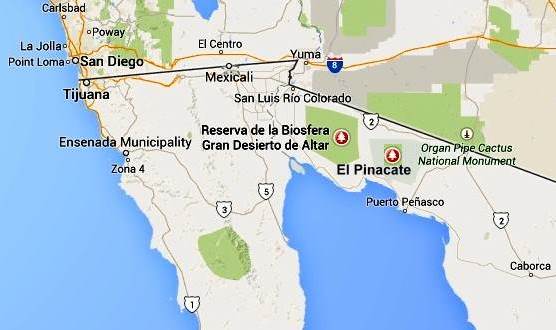
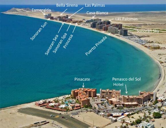
The Mexican government is funding a 100-million-dollar project to build Mexico’s first cruise ship home port at Puerto Peñasco (Rocky Point) in Sonora on the Sea of Cortés (Gulf of California). Construction began in 2013 and is scheduled to be completed by early in 2017.  Proponents hope that the port will help transform the existing town (population about 60,000) into a fully-fledged tourist resort, taking advantage of its proximity to Phoenix and Tucson in Arizona. The project includes a state-of-the-art terminal and convention center.

pinacate-map-google

The town already has a small international airport, inaugurated in 2008, which has a daily capacity of 2000 passengers and would need to be expanded if the port takes off.

Puerto Peñasco has an embryonic tourism industry at present, mainly attracting Arizonans (it is their nearest beach), fishing enthusiasts, and school and college students during spring-break (attracted, in part, by the legal drinking age being 18 in the town, compared to 21 in Arizona).

puerto-penasco

Puerto Peñasco also has research stations of the Universidad de Sonora: its Centro de Investigaciones Científicas y Tecnológicas (Scientific and Technological Research Center) and its Centro de Estudios del Desierto (Center for Desert Studies).

According to cruise line statistics, the number of Mexicans taking cruises in 2014 rose by 15%, but analysts argue that many Mexicans stay at home and are unable to take cruises at present because they lack a U.S. visa. Establishing a home port in Mexico, they argue, would therefore open up a significant new market. A cruise ship port at Puerto Peñasco would clearly have immense impacts on the town, boosting the local economy and generating up to 2,500 direct and 5,000 indirect jobs.

However, critics say this will come at a cost. They cite potential problems related to local residents, wildlife and biodiversity. They fear that development of the town will raise property prices beyond the level of affordability of local residents. A Tucson-based non-profit, The Intercultural Center for the Study of Deserts and Oceans is working with local fishermen and government agencies to “empower coastal communities in the Northern Gulf of California region with the knowledge and tools to create sustainable livelihoods that exist in concert with the surrounding natural and multicultural environment”. The research center believes the port development will lead to environmental changes adversely affecting important fishing grounds. The center has also expressed concern about the potential hazards to nesting sites used by sea turtles.

Related posts:

Mexico attracting significant inflows of FDI

 Mexico's geography in the Press, Updates to Geo-Mexico  Comments Off on Mexico attracting significant inflows of FDI
May 212015
 

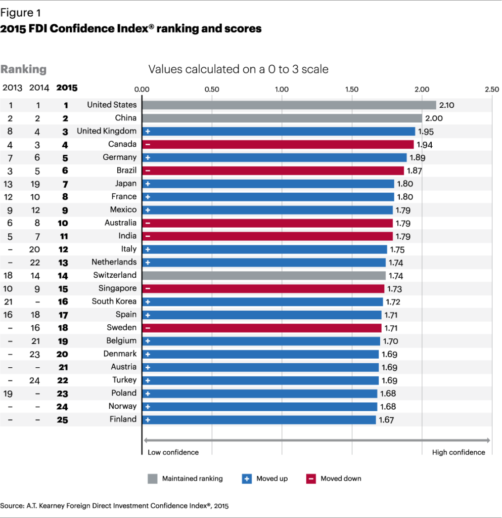
According to the 2015 Direct Foreign Investment Confidence Index of consultancy A.T. Kearney, Mexico is currently the ninth most attractive country worldwide for FDI (Foreign Direct Investment). Mexico has risen 3 places in the rankings since the 2014 Index was released.

The report highlights the improving business climate in Mexico following the implementation of the government’s reform agenda, and says that “investors continue to be drawn to opportunities in many sectors, including manufacturing, energy, and telecoms”.

The top 10 countries in the overall FDI rankings (see graph) are U.S., China, U.K., Canada, Germany, Brazil, Japan, France, Mexico and Australia.

FDI-COnfidence-Index2015

The report says,

Mexico gains three spots to reach 9th, as President Enrique Peña Nieto’s reform agenda continues to improve Mexico’s business climate. Its 2013 FDI levels of $38 billion were an all-time high, with the majority of investment targeted at Mexico’s growing manufacturing sector, including high-value-added electronics. Mexico’s Economy Ministry has reported that flows fell to $22.6 billion in 2014, with inflows of $33.9 billion offset by $11.4 billion in outflows. Significant reforms in the energy sector will occur this year to allow foreign private investment.

As a result of the telecom reforms that targeted Carlos Slim’s América Móvil, which controls 70 percent of the market, customer prices fell nearly 17 percent between February 2013 and January 2015. In response to the policy changes, AT&T made a $5 billion divestment in América Móvil and subsequently acquired Grupo Iusacell SA, Mexico’s third-largest wireless operator, for $1.7 billion. Going forward, these reforms are expected to open up growth opportunities for smaller competitors.

In November 2014, the American chemicals maker PPG Industries acquired paints maker Consorcio Comex for $2.3 billion. This followed the rejection by the Mexican federal competition authority of the sale to Sherwin-Williams for a proposed $2.34 billion on the grounds that it would create unfair market conditions.

According to this recent press report, Mexico’s FDI during the first three months of 2015 totaled $7.573 billion, an all-time record for the first quarter. The figure comes from 1357 separate investments originating from the USA (59.4%), Spain (14.3%), Japan (8.2%), South Korea (4.8%), France (2.9%), and the Netherlands (2.3%), with the remaining 8.1% coming from 48 other nations.

Author David Lida on Mexico City’s transportation systems

 Books and resources, Mexico's geography in the Press  Comments Off on Author David Lida on Mexico City’s transportation systems
Apr 272015
 

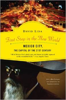
David Lida is a well-known and highly respected author who has lived in Mexico City (on and off) for over twenty years. His books include First Stop in the New World: Mexico City, Capital of the 21st Century and the short-story collection Travel Advisory: Stories of Mexico. He also blogs about Mexico City:

lida-bookHis article a few months back in the Guardian about life in Mexico City – An urbanist’s guide to Mexico City: ‘Transport is an adventure and often a nightmare” – is an informative account of his love-hate relationship with the city. The following short extracts from his article, relating to the geography of the city, should sharpen your appetite to read more:

“The greater metropolitan area of Mexico City is home to about 22 million people (known as chilangos) and is laid out over about 600 square miles…. The most recent study, from 2007, says that it takes chilangos an average of an hour and 17 minutes to get from one place to another.”

“Half of the working population toils in the informal economy – parking cars, cleaning houses, packing groceries, selling things on the street. The middle class is squeezed month by month rather than daily, while perhaps 10% has a jolly time with plenty of discretionary income. According to Forbes, Mexico’s elite upper class is made up of 1.7% of the population.”

“Although it is not comprehensive, and the stations are spaced further apart than they are in some other places, if your destination is on the route the metro is the fastest, cheapest and best way to get around Mexico City…. Taxis are abundant and cheap, and depending on your route, can also be quick. As in any big city, you want to avoid getting stuck in rush-hour traffic whenever possible.”

“Bicycling has definitely become more popular in the city, but because of the way people drive cars, I think it is a terrifying prospect.”

“What I believe we are seeing here is a worldwide phenomenon in which the well-to-do are getting sick and tired of long commutes from gated communities on the outskirts and want to move closer to the centre. Many of the poor will probably end up being shunted further and further away from where they have to work.”

“In greater Mexico City there are about 85,000 streets and 5,000 neighbourhoods. Of those streets, about 850 are called Juárez, 750 are named Hidalgo, and 700 are known as Morelos. Two hundred are called 16 de Septiembre, while 100 more are called 16 de Septiembre Avenue, Alley, Mews or Extension…. Like London’s A to Z or Michelin’s Paris Plan, there is a street map in book form here called the Guía Roji, which weighs in at over 150 two-sided pages of maps. If you only own one book while you live here, better make it the Guía Roji.”

Extracts come from David Lida’s – An urbanist’s guide to Mexico City: ‘Transport is an adventure and often a nightmare”. Enjoy!

Related posts:

Apr 092015
 

The Institute for Economics and Peace (IEP) has published its Mexico Peace Index. The following excerpts come from the Executive Summary of the Mexico Peace Index Report 2015:

The Mexico Peace Index provides a comprehensive measure of peacefulness in Mexico from 2003 to 2014. The 2015 report aims to deepen the understanding of the trends, patterns and drivers of peace in Mexico while highlighting the important economic benefits that will flow from a more peaceful society.
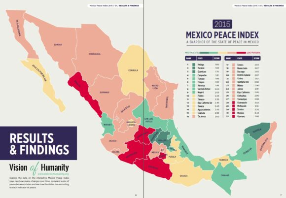
Mexico Peace Index, 2015

Mexico Peace Index, 2015. Credit: Institute for Economics and Peace.

The map above shows the relative values of the MPI by state, where dark blue means the most peaceful states and dark red the least peaceful (most violent) states.

Improvement since 2012

According to the report, Mexico’s peace has improved 10.5% since 2012, continuing the trend from 2011; however, 2014 saw very little improvement, improving only 0.7%. It is too early to determine whether this is a new trend. Mexico’s level of peace in 2014 approached 2007 levels, when homicide and violent crime began to increase rapidly.

The MPI indicators registering the largest improvements in the last two years were the homicide rate, which fell by 30%, and the level of organized crime, which improved by 25%. All three measures in the organized crime indicator (extortion, kidnapping and narcotics offenses) improved. There was also a significant reduction in the violent crime rate, which fell by 12%.

Furthermore, the recorded increase in peacefulness was widespread. In the last two years, 26 out of the 32 states saw improvements in peacefulness, with all of them recording reductions in the violent crime rate and 23 states recording reductions in the homicide rate. The biggest improvements were recorded in the least peaceful states; contrary to the overall trend, the most peaceful states became slightly less peaceful. These diverging trends resulted in a substantial narrowing of the gap between the least peaceful and the most peaceful states.

In contrast, during the same two-year period, weapons crime increased significantly and was up by 11%. The three other indicators that make up the MPI (justice efficiency, incarceration and police funding) have plateaued or slightly deteriorated and are now at record highs.

The justice efficiency indicator continued to decline, which is very concerning, with the number of homicides relative to the number of prosecutions doubling from 1.45 in 2006 to 3.43 in 2013. The justice efficiency indicator measures the ratio of homicide convictions to homicides in a given year and is used as a proxy for impunity.

Additionally, the rate at which people were sentenced to prison fell from 210 per 100,000 people to 104 from 2003 to 2014. Combined with the deterioration in the justice efficiency indicator, this is a troubling trend that highlights the urgent need to fully implement the current justice reforms.

It should be noted that the declines in homicides and gang-related violence do not necessarily mean that criminal organizations are less powerful; they may have become more circumspect in their activities. This reflects a paradox in Mexico: while indicators of peacefulness have greatly improved in the last four years, many Mexicans still report high perceptions of criminality. Additionally, officially recorded rates of homicide and violent crime are still very high by global standards.

Under-reporting of violent crime and other criminal activities is a serious issue in Mexico, with IEP estimating that rape is reported only eight percent of the time and assault only 23%. To create a more accurate index, IEP has adjusted all indicators for under-reporting rates.

For many, these concerns create doubt about the reliability of criminal justice statistics. To determine the veracity of the official data, IEP compared various alternative datasets and victimization surveys against the official data. The results tend to support the trend towards higher levels of peace, but with some qualifications.

Main findings of the Mexico Peace Index 2015

  • Mexico has experienced a large decrease in violence since 2011, with the national level of peace improving by 16%.
  • Progress in peace plateaued last year; it is too early to determine if this is the start of a new trend.
  • The level of peace as measured by the 2015 MPI is still 18% lower than in 2003.
  • The most peaceful state in Mexico is Hidalgo, followed by Yucatán, Querétaro, Campeche, Tlaxcala and Chiapas.
  • Of the 76 largest metropolitan areas of Mexico, the most peaceful is Orizaba in Veracruz, and the least peaceful is Culiacán in Sinaloa.
  • The eastern region remains the most peaceful in Mexico, while the northern region is still the most violent, although the gap between the north and the other regions is now at its lowest point since 2004.

Trends in Peace

Peace improved in the majority of states in Mexico in the last two years, with 26 out of 32 states improving. The largest improvements were in the northern region, which improved 17.8%. The gap in the levels of peace between the least and most peaceful states is now at its lowest point since 2006.

Over the last two years, the largest decreases in violence have been in the homicide rate, which fell almost 30%, and the level of organized crime, which fell by 25%.

The only indicator that recorded a significant deterioration in the last two years is weapons crime, which increased by 11%. The police funding indicator and the justice efficiency indicator recorded very slight deteriorations, reaching their worst levels in 2014.

The fall in the homicide rate is mainly due to a reduction in homicides related to organized crime, as the biggest reductions were recorded in the states with the worst levels of drug cartel activity.

While there is some doubt about the accuracy of government crime statistics, multiple data sources do support a decline in the homicide rate over the last two years. This strongly suggests the progress in peace is real.

On an international comparison, Mexico fell 45 places in the Global Peace Index between 2008 and 2013. It remains the least peaceful country in Central America and the Caribbean.

Economic Value of Peace in Mexico

The total economic impact of violence in Mexico in 2014 is estimated to be $3 trillion pesos or US$233 billion, equivalent to 17.3% of GDP. This represents $24,844 pesos, or almost US$1,946, per citizen. This is a 16.7% decrease from 2012, when the total economic impact of violence in Mexico was $3.57 trillion pesos.

The states with the highest per capita economic impact from violence are Guerrero, Morelos, Baja California and Tamaulipas, with the economic impact in Guerrero at $43,666 pesos/person. If the 16 least peaceful states in 2003 had experienced the same economic growth as the 16 most peaceful states in 2003, then the Mexican economy in 2014 would be $140 billion pesos or 13% larger.

Related posts:
Good news for Mexico’s little sea cow, the vaquita marina

 Mexico's geography in the Press  Comments Off on Good news for Mexico’s little sea cow, the vaquita marina
Mar 232015
 

Good news for Mexico’s “little sea cow”, the world’s smallest porpoise, known in Spanish as the vaquita marina, currently the most endangered cetacean in the world.

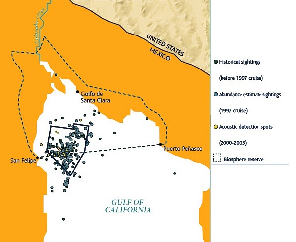
The federal government has approved a compensation plan designed to protect the vaquita marina, with a budget of 69 million dollars, spread over two years. Most of the funds will be used to pay 1,300 fishermen in San Felipe and Santa Clara in the upper Sea of Cortés (Gulf of California) not to fish.

There are thought to be fewer than 100 vaquitas remaining in the wild. Banning fishing in the main area where the little sea cows are found will eliminate the loss of further vaquitas as bycatch.

Map of sightings and acoustic detection spots. Adapted from North American Conservation Action Plan for the vaquita

Map of sightings and acoustic detection spots. Adapted from North American Conservation Action Plan for the vaquita

Besides paying compensation to fishermen in return for not fishing, some funds will be allocated to finance annual inspections and introduce surveillance drones to ensure compliance with the conservation plan and detect any illegal fishing. The unmanned drones will be managed by Mexico’s Environmental Protection Agency (Profepa).

Some funds will also go to research, with an emphasis on trying to develop a vaquita-safe shrimp net that can safely be used in the area.

Banning fishing for the 860 holders of fishing licenses in Santa Clara and the 494 licensed fishermen in San Felipe, may help the vaquita marina, but will bring some adverse consequences to the local economy since there no compensation is on offer for those workers, including many women, who are involved in fish processing and other parts of the production chain.

Not long enough

As Luis Fueyo, the head of Mexico’s National Protected Areas Commission (Conanp) has said in recent press interviews, the vaquita marina cannot possibly recover in two years because they only reproduce every two years and only 25 of those remaining are of reproducing age. Fueyo says that the plan needs to look ahead 20 to 30 years in order to create a viable population of 5,000 vaquita.

So, while a two year ban is nowhere near long enough to achieve any measurable increase in the vaquita marina population, it is a good first step in the right direction. Hopefully, the federal government will allocate additional funding in future years to ensure that the world does not lose this critically endangered porpoise.

Related posts:

Beach replenishment needed in Quintana Roo

 Mexico's geography in the Press  Comments Off on Beach replenishment needed in Quintana Roo
Mar 022015
 

Officials in Quintana Roo claim that beach replenishment in the state requires the investment of at least 500 million pesos (about 35 million dollars) in the next few years, and are asking for federal help.

After Hurricane Wilma in 2005, many beaches in Quintana Roo were badly damaged. Following the hurricane, initial beach restoration efforts were funded by the federal Tourism Secretariat, with maintenance then passed over to local (municipal) authorities and the state government. The restoration program included the planting of more than 8,000 palm trees in an effort to help stabilize the coast. However, storms in late 2014 caused considerable damage to beaches, especially the Gaviota Azul beach in Punta Cancún, prompting tourism representatives to call for renewed investment in restoration.

State officials have singled out five areas where the beaches are of particular concern:

  • Cancún
  • Playa del Carmen
  • Isla Mujeres
  • Cozumel
  • Holbox Island

Quintana Roo has budgeted 5 million pesos in this year’s budget to complete the five Environmental Impact studies needed prior to applying for federal funding.

In related news, four Quintana Roo towns have applied for Magic Town status:

  • Tulum
  • Holbox
  • Isla Mujeres
  • Felipe Carrillo Puerto

Quintana Roo currently has only one Magic Town: Bacalar.

The Tourism Secretariat has previously announced that it plans to add 17 towns to the list this year, bringing the total by year-end to 100. Towns that have applied for Magic Town status will be evaluated in June this year, with decisions expected to be announced in July. Given the number of towns submitting applications, some locations are clearly going to be disappointed in this round of nominations.

Related posts:
Which cities in Mexico have the highest cost of living?

 Mexico's geography in the Press  Comments Off on Which cities in Mexico have the highest cost of living?
Feb 262015
 

The recently published ‘Costo de Vida Nacional 2014-2015’ report from Recursos Humanos Mercer (Mercer Human Resources) provides a comparison of the cost of living in 42 cities, based on the cost of 182 different products and services. The study is released annually to provide a basis for corporations to decide on employee remuneration to reflect the varied living costs in different parts of the country.

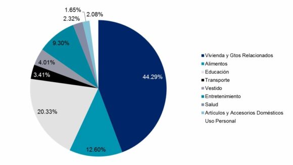
The products and services used for comparison are divided into 9 different groups:

  • Housing
  • Food
  • Education
  • Public Transport
  • Clothing and footwear
  • Entertainment
  • Health
  • Domestic appliances
  • Personal care
Part played by different products/services in the cost of living of cities in Mexico

Part played by different products/services in the cost of living of cities in Mexico. Source: Mercer

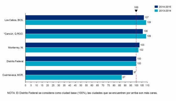
The values for each city reflect differences from the cost of living in Mexico City, which is assigned an index value of 100. The cities with the highest cost of living in 2014-2015 were Los Cabos, Cancún, Monterrey, Mexico City and Cuernavaca (graph below). In the 2013-2014 version, the cities with the highest cost of living were Cancún, Los Cabos, Monterrey, Mexico City and Puebla.

Cities with the highest cost of living in Mexico

Cities with the highest cost of living in Mexico. Source: Mercer

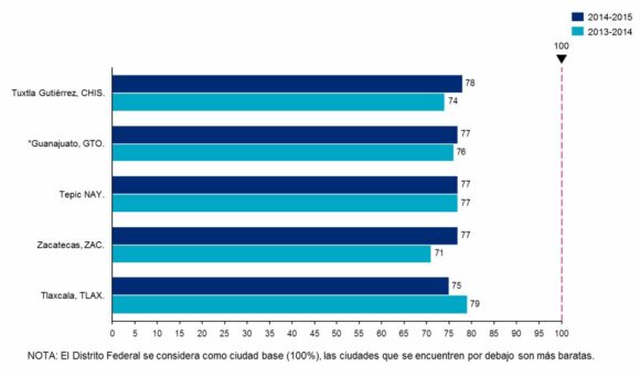
The cities with the lowest cost of living in 2014-2015 were Tlaxcala, Zacatecas, Tepic, Guanajuato and Tuxtla Gutiérrez (graph below). In 2013-2014, the cities with the lowest cost of living were Zacatecas, Tuxtla Gutiérrez, Guanajuato, Tepic and Veracruz.

Cities with the lowest cost of living in Mexico

Cities with the lowest cost of living in Mexico. Source: Mercer

Related posts:
Slight decrease in the number of “Los Ninis” in Mexico

 Mexico's geography in the Press, Updates to Geo-Mexico  Comments Off on Slight decrease in the number of “Los Ninis” in Mexico
Feb 092015
 

Los ninis are young people (aged 15-29) that “ni trabaja, ni estudia” (neither work nor study). They have become the focus of much press attention in the past few years, often accompanied by the phrase “Mexico’s lost generation”.

nini-logo

According to a recent OECD report, “Education at Glance 2015”, two out of every ten Mexicans in the 15-29 age group neither studied nor worked in 2013, the latest year for which there is data. The report found that 22.3% of Mexican in that age category were ninis, a slight decrease compared to 25.0% in 2011. After population increase is taken into account, Mexico has about 200,000 fewer ninis than in 2011.

Mexico’s percentage of ninis is above the average for all 34 OECD member countries, and is the fifth highest among OECD members, after Turkey (31.3%), Greece (28.5 %), Spain (26.8 %) and Italy (26.1 %). Very few of Mexico’s 7.3 million ninis (only 3.8%) are technically “unemployed”; most ninis have not actively sought work and are therefore considered “inactive”.

In Mexico, most ninis are female. For example, in the 20-24 age group, around 10% of males are ninis, compared to 40% of females.

The figure of 7.3 million will no doubt again be disputed by Mexico’s Secretariats of Education (SE) and of Labor and Social Welfare. In 2011, the Secretariats issued a joint rebuttal of the OECD figure, and claimed that 78% of those reported by OECD as ninis were young married women, with children, who dedicated themselves to home-making. The Secretariats emphasized that the figures revealed a gender inequality in access to educational and economic opportunities, linked to cultural patterns where many young women still saw marriage and motherhood as their preferred or only option.

Related posts:
Ground subsidence in Mexico City threatens 10,000 homes

 Mexico's geography in the Press  Comments Off on Ground subsidence in Mexico City threatens 10,000 homes
Feb 052015
 

The local authorities in Iztapalapa, in the eastern section of the Mexico City Metropolitan Area, and one of the most interesting locations in Mexico in which to witness Easter celebrations, calculate that around 10,000 homes are in the area are at “high risk” of serious damage due to ground subsidence. Some parts of the city are falling in elevation as the ground contracts by up to 40 cm/yr.

Low-lying Iztapalapa is one of the most densely populated parts of the city, and is also prone to frequent flooding. Experts say that the severe damage evident in many buildings in the area has been occasioned by ground subsidence, due to the excessive volumes of water being pumped out of the subsoil to satisfy the insatiable demand of Mexico City.

In a short 3-minute news video in Spanish that is linked to in this recent article, Lourdes, a local resident offers us a tour of her home, showing us the damages caused by subsidence. She describes how “the crack that started from outside the house has widened every day and is now almost the width of a hand.” The video shows how the walls of her home are separating; the house is clearly in danger of collapse. Lourdes lives in this house with her four children; some rooms are already far too damaged to be safely used by the family.

Related posts:

Mexico has seven of the world’s 100 best hotels

 Mexico's geography in the Press  Comments Off on Mexico has seven of the world’s 100 best hotels
Jan 262015
 

A survey of more than 75,000 Condé Nast Traveler readers placed seven Mexican hotels in the world’s top 100.

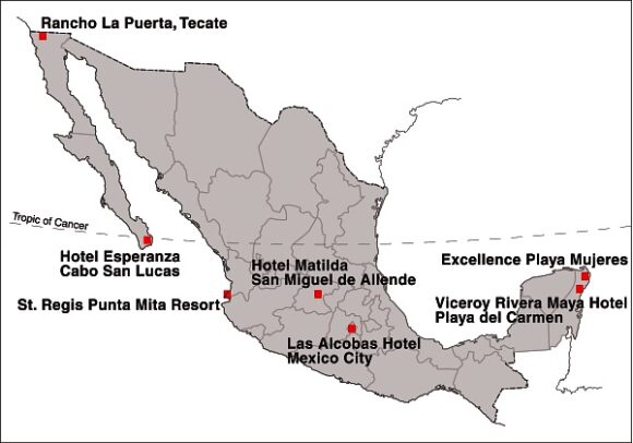
Location of Mexico's Top Seven Hotels

Location of Mexico’s Top Seven Hotels

Mexico’s top hotel (#15 in the rankings) was the Viceroy Rivera Maya hotel, in Playa del Carmen (Quintana Roo). It was joined in the top 100 by Rancho La Puerta in Tecate (Baja California), St. Regis Punta Mita Resort (Nayarit), Las Alcobas hotel (Mexico City), Hotel Matilda in San Miguel de Allende (Guanajuato), Hotel Esperanza in Cabo San Lucas (Baja California Sur) and the Excellence Playa Mujeres (Quintana Roo).

In related news, Grupo Posadas is investing one billion dollars over the next three years to open 49 new hotels, many of them in the firm’s Fiesta Americana chain. Meanwhile, at the opposite end of the hotel spectrum, Motel 6, the “McDonald’s of the hotel industry”, which has 1,200 locations in the USA and Canada, is opening 30 hotels in Mexico within the next three years.

The operator of the Motel 6 chain, G6 Hospitality, will introduce both its brands: Motel 6 and Estudio 6 (designed for extended stays) during its first foray into Latin America. The first of the new hotels will open in Salamanca (Guanajuato) in late-2015, with additional locations to follow, including Mexico City, Monterrey and several resort destinations.

Related posts:

Mexico City looks to expand its metro network

 Mexico's geography in the Press  Comments Off on Mexico City looks to expand its metro network
Dec 222014
 

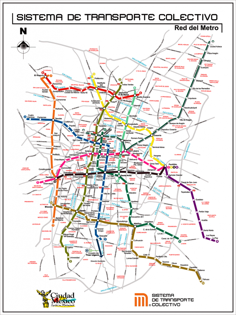
Plans to expand Mexico City’s metro network, announced by the federal government, will require investments totaling around 2.8 billion dollars. The first contracts are expected to be awarded next year, with most projects due to be completed by 2018, the final year of this administration.

Mexico-City-Metro-MapThe major proposals affect three metro lines:

Metro Line A (Pantitlán to La Paz) will be extended 12.9 kilometers to the southeast, with six new intermediate stations, to Chalco in the state of Mexico, at a cost of about 1 billion dollars. [Update – March 2016 – officials have described the proposal to extend line A as “cancelled“]

The lengthening of Metro Line 4 (Martín Carrera to Santa Anita) northeastwards to reach Tepexpan will require investments of 1.5 billion dollars and add 19 intermediate stations as well as a terminal in Tepexpan. It will have improved links to other Metro and Metrobús lines.

Metro Line 12 will be extended northwards beyond its present terminus in Mixcoac to include new two intermediate stations and a new terminal station in Observatorio. This line will improve transit through Observatorio for passengers, including those using the future high-speed train link between Toluca and Mexico City.

Note that the elevated (above ground) southern section of Metro Line 12 between Tlahuac and Atlalilco stations, closed for repairs since March 2014, remains closed and is not expected to reopen until the second half of 2015. A replacement bus system has been established between those stations.

Useful links:

Related posts:

Dec 152014
 

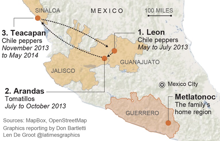
A week ago, we highlighted the first of a series of four articles in the LA Times about the living and working conditions faced by migrant farmworkers in Mexico as they harvest crops that end up on dinner tables not only in Mexico, but also in the USA. The other three articles in the series are just as disturbing, but make for compelling reading.

la-mexico-farm-labor-map-alejandrina-2014-1212

The pilgrimage of 12-year-old Alejandrina Castillo during a single year as she accompanies her migrant farmworker parents. Credit: LA Times

The journalist and photographer responsible for this series of articles deserve high praise for their persistence and determination in exposing some of the “dirty little secrets” of Mexico’s agribusiness sector.

Links to the full series on the LA Times website:

Part 1: Hardship on Mexico’s farms, a bounty for U.S. tables – Farm exports to the U.S. from Mexico have tripled to $7.6 billion in the last decade, enriching agribusinesses, distributors and retailers. But for thousands of farm laborers south of the border, the boom is a story of exploitation and extreme hardship.

Part 2: Desperate workers on a Mexican mega-farm: ‘They treated us like slaves’ – A raid exposes brutal conditions at Bioparques, one of Mexico’s biggest tomato exporters, which was a Wal-Mart supplier. But the effort to hold the grower accountable is looking more like a tale of impunity.

Part 3: Company stores trap Mexican farmworkers in a cycle of debt – The company store is supposed to be a lifeline for migrant farm laborers. But inflated prices drive people deep into debt. Many go home penniless, obliged to work off their debts at the next harvest.

Part 4: Children harvest crops and sacrifice dreams in Mexico’s fields– About 100,000 children under 14 pick crops for pay at small- and mid-size farms across Mexico, where child labor is illegal. Some of the produce they harvest reaches American consumers, helping to power an export boom.

Related posts:

Access to safe water is a human right in Mexico

 Mexico's geography in the Press  Comments Off on Access to safe water is a human right in Mexico
Dec 132014
 

Earlier this year, David Korenfeld, the director of Mexico’s National Water Commission (Conagua), was chosen to head the inter-governmental council that oversees UNESCO’s International Hydrological Program (IHP). The IHP is the only inter-governmental program of the U.N. system devoted to water research, water-resources management, and education and capacity building.

In his acceptance speech, Korenfeld called for “greater synergy between decision makers and specialists to combine theory and practice” and stated that “significant challenges remain [in the water sector], including integral basin management, application of the human right to water and water security and sustainability in the context of climate change.

Recent events demonstrate that Mexican courts are happy to uphold the view that water is a basic human right. The 5 Dec 2014 issue of the OOSKAnews, a newsletter dedicated to water industry professionals, included the following short piece about a landmark recent decision by Mexico’s Supreme Court that represents the first ever Supreme Court decision in Mexico upholding the nation’s stance that “water is a basic human right.”

The Supreme Court has for the first time awarded an “amparo” (similar to an injunction, a remedy for the protection of constitutional rights), based on the human right to water.

In this case, members of the court unanimously sided with Lidia Velázquez Reynoso, a resident of the Ampliación Tres de Mayo area in the municipality of Xochitepec, in the state of Morelos.

In their ruling, the court said authorities must meet their obligation to provide Velázquez’s residence with “access, availability, and sanitation of water for personal and domestic consumption in a sufficient, safe, acceptable, and affordable form.” A lower court had already ruled in favor of Velázquez, but the case was appealed.

The Supreme Court said responsible authorities had failed to guaranteed regular delivery of water, since merely connecting Velázquez’s residence to the water system was not good enough. Water quality and volume must also be taken into account. The court said that the water must meet World Health Organization standards, and the volume provided must be at least 50 to 100 liters per person per day.

The court ordered authorities to not only deliver the water to Velázquez, but also to remit records showing that the water meets national and international standards.

(OOSKAnews, 5 December 2014)

Related posts:

Dec 082014
 

Every so often, a news article comes along which rattles our perceptions, causes us to think, and begs us to discuss big issues. This is one of those times.

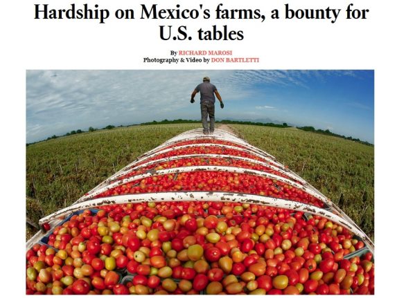
Los Angeles Times reporter Richard Marosi and photojournalist Don Bartletti traveled across nine Mexican states, observing conditions and interviewing workers at some of the mega-farms that have powered the country’s agricultural export boom.

The resulting article, the first of a four-part series, was published yesterday in the Los Angeles Times, and offers lots of potential for serious discussions in geography classes around the world about agribusiness practices, supply chains, the persistence of inequalities, and a host of other issues. The article is accompanied by some great photographs and short, informative videos.

la-times-article

In “Hardship on Mexico’s farms, a bounty for U.S. tables“, Marosi and Bartletti find that thousands of laborers at Mexico’s mega-farms endure harsh conditions and exploitation while supplying produce for American consumers.

This is a must-read series for anyone interested in the Geography of Mexico, and we can’t wait to see the next three parts of this series.

Related posts:

Which states in Mexico are the most competitive?

 Maps, Mexico's geography in the Press  Comments Off on Which states in Mexico are the most competitive?
Dec 032014
 

The Mexican Institute for Competitiveness (Instituto Mexicano para la Competitividad AC, IMCO) has published its annual analysis of the competitiveness of Mexico’s states. The report provides some interesting insights into which areas of Mexico are “most competitive” in business terms, defined as their capacity to attract and retain investments and a talented workforce.

This suggests a business environment that maximizes the socio-economic potential of both the business entities and individuals residing in a a specific area. It also suggests that any improved well-being (economic and social) will be maintained (sustained).

The index is based on 89 indicators in 10 sub-indices. The 10 major factors include the reliability and objectivity of the legal system, the sustainable management of the natural environment, the stability of macroeconomic policies, the degree to which society is non-divisive, educated and healthy, and the stability and functioning of the political system.

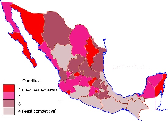
The latest report relies on 2012 data. Mexico’s basic pattern of competitiveness at the state level is shown in the map.

Mexico, 2014. Map: Tony Burton; all rights reserved

Competitiveness in Mexico, 2014. Map: Tony Burton; all rights reserved

The five most competitive states in Mexico are:

  • Federal District (Mexico D.F.)
  • Baja California Sur
  • Aguascalientes
  • Nuevo León
  • Querétaro

While a full analysis of why some states are more competitive than others is beyond the scope of this post, the single most striking aspect of this map is the persistent low degree of competitiveness of several of Mexico’s poorest states, such as Guerrero, Oaxaca and Chiapas.

In general, states in Northern Mexico are noticeably more competitive than those in Southern Mexico. Two areas on opposite coasts where tourism is extremely important to the local and national economy – Baja California Sur and Quintana Roo – are both very competitive.

Mexico’s economy and workforce are analyzed in chapters 14 to 20 of Geo-Mexico: the geography and dynamics of modern Mexico. Ask your library to buy a copy of this handy reference guide to all aspects of Mexico’s geography today! Better yet, order your own copy, which will still arrive in time for Christmas…

Related posts:

Mexico is the world’s leading exporter of beer

 Mexico's geography in the Press, Updates to Geo-Mexico  Comments Off on Mexico is the world’s leading exporter of beer
Nov 262014
 

For the fourth year running, Mexico was the world’s leading beer exporter in 2013, with beer exports reaching a record 2.2 billion dollars, a rise of 4.2% compared to 2012, and well ahead of both the Netherlands ($2.0 billion) and Belgium ($1.6 billion).

cerveza-victoria-bicentenaryMexico has become the leading supplier of beer to the USA and now accounts for almost 50% of that country’s beer imports. It is also the leading supplier to Australia, Chile, Guatemala, Argentina and New Zealand, as well as the third leading supplier to Canada and the fourth largest to China and Japan.

The two major beer producers in Mexico are Grupo Modelo and Cervecería Cuauhtémoc Moctezuma.

The leading export brand is Corona which reaches 180 countries around the world. Over the past decade, Mexico’s beer industry has grown at 2.5%/year and analysts expect this rate to quicken, predicting output will rise from 71 million hectoliters this year to 82 million in 2020.

In the USA, quite a few Mexican beers will be consumed this Thanksgiving Day… Happy Thanksgiving to all!

Related Posts:

The abduction and presumed murder of 43 students in the state of Guerrero

 Mexico's geography in the Press  Comments Off on The abduction and presumed murder of 43 students in the state of Guerrero
Nov 182014
 

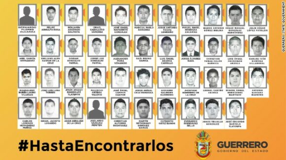
The disappearance several weeks ago, and presumed murder, of 43 students from a teachers’ college in Ayotzinapa in the state of Guerrero has shocked the nation and sent shock-waves around the world. The isolated mountainous parts of the state of Guerrero have long been home to some of the worst violence and most severe poverty in Mexico. The students went missing in the town of Iguala on 26 September 2014.

We appreciate that many of our readers will already be well informed about recent events, but hope that the following summary, with its links to English-language sources, will be useful.

Mexico’s attorney general has announced that a drug cartel, operating in tandem with the mayor of Iguala and the mayor’s wife, had kidnapped and killed the students, before burning their bodies beyond recognition and dumping the remains in plastic bags in a river. According to some versions, local police were not only aware of the events, but complicit in them.

mexico-kidnapping-horizontal-gallerySoon after the disappearance of the students, several mass graves were located on the outskirts of Iguala, but none of the remains has yet been positively identified as belonging to any of the missing students. However, the remains did include the body of a Roman Catholic priest from Uganda, missing since May 2014. John Ssenyondo, who had been serving in the region since 2010, was allegedly abducted by armed men for refusing to baptize the daughter of a suspected narco.

Earlier this month, security experts searching the landfill site near the town of Cocula (where gang members allegedly killed and burned the students) found rubbish bags with human remains. The charred remains have been sent to a specialized laboratory in Innsbruck, Austria, for testing, but results will not be known for several weeks.

A judge in Guerrero has since charged the city’s former mayor, Jose Luis Abarca, with being the mastermind behind the students’ disappearance, and of responsibility for the murder of six people killed in clashes between the trainees, police and masked gunmen on the night of 26 September 2014. The government has detained more than 70 people in connection with the disappearance of the students. Maria de los Angeles Piñeda, the wife of the local mayor is alleged to be the head of the area’s major drug cartel. Abarca and his wife have both been arrested. The small town of Iguala, site of the murders, installed a new mayor, Luis Mazon, after the incumbent was arrested for ordering the massacre, but he resigned in disgust after only a few hours in office, to be replaced by Silviano Mendiola.

Bloody demonstrations are taking place across the country, threatening tourism and denting the carefully-crafted public relations image of President Enrique Peña Nieto.

In Chilpancingo, the state capital of Guerrero, 600 protestors set fire to cars, a congressional office and the city hall.

The tourist resort of Acapulco has also been the scene of demonstrations. For a short time protestors prevented flights from taking off from the city’s airport, and have also blocked highways. The hotel occupancy rates plummeted to 20% for a time, before beginning to rise again in recent days.

In Mexico City, protestors set fire to one of the wooden doors of the Presidential Palace on the zocalo, Mexico City’s main square. The president has an office in the building but was leading a trade mission to China at the time.

Speaking to Fox News Latino recently, a student leader from the Ayotzinapa school said that, “It’s a national movement that’s launching. People are really upset in Mexico. It’s a movement for all citizens that is sparking protests across the country. That’s what happening now. We’re sending caravans to Chihuahua, Zacatecas, all the states from north to south. It’s family members [of the victims] and student-teachers.” The students also accept fire-bombings as a valid form of political expression.

Reactions in the USA have been mixed. For example, see:

Recycled plastic boats for Xochimilco?

 Mexico's geography in the Press  Comments Off on Recycled plastic boats for Xochimilco?
Oct 092014
 

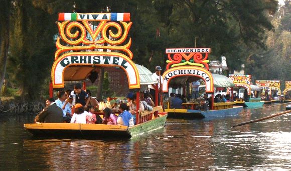
What will they think of next? Officials in Mexico City have plans to provide the tourist zone of the Xochimilco canals with environmentally friendly boats and barges and to gradually substitute the usual wooden ones, which have very high maintenance costs. The plan was unveiled a few weeks ago by Mauricio León, director of infrastructure, modernization and innovation for the Federal District.

Xochimilco (Wikipedia; creative commons)

Xochimilco (Wikipedia; creative commons)

Apparently, the traditional wooden vessels, known as trajineras, with their colorful arches, formerly used mostly to transport goods but now dedicated almost exclusively to tourism, require “an enormous expense” each year since they need to be renovated annually, in part due to “the deterioration in recent years” of the water quality in the canals. According to León, the water contains high levels of fungi that degrade the wood. (Q. In that case, why not clean the water, and keep the traditional designs made of wood?)

Mexico City officials have already launched a prototype of the new, plastic, ecologically-sound craft, and hope that the owners of the traditional gondola-like non-motorized boats will form a cooperative to gradually replace them. The design of the new “technoecological” vessels was created by scientists at the National University (UNAM) and preserves the typical characteristics that have made it a widely recognized symbol of tourism in Mexico.

The great advantage of the new boats, made of recycled PET plastic (some of it no doubt pulled from the canals), polyethylene and volcanic clay is their greater durability and stability. Proponents claim that since they are made of recycled material, unlike the traditional ones for which 20 trees have to be cut down to make each trajiinera, the new boats are much cheaper, require less maintenance and their durability is much greater, with the potential to last up to 120 years.

There is one slight problem: the cost of the machinery required to make them. Authorities hope to persuade the boatmen to form “a cooperative able to get financing for the machines,” which will require an investment of some 5 million pesos ($380,000).

This is a long-term plan, because even when the machines are installed, they can produce only about three or four boats a week, and there are an estimated 1500 trajineras currently plying the canals in Xochimilco.

Related posts: