Oct 062014
 

According to press reports such as Buscan dar “nueva cara” a Puerto Arista (in El Economista), there are plans afoot to develop nearby mangrove swamps as part of an ecotourism project. Local architects in the coastal town of Puerto Arista in Chiapas are backing the project to build what might best be called Mangrove Riviera.

The state government has released this 4-min video that summarizes the plan, with models and images of the area:

The initial investment required to get Riviera Manglar “Pakal Ahau” under way is around $120 million. The major advantage, from the state’s point of view, is that it would open up a new region of the state for tourism, cashing in on the area’s natural wealth, especially its mangroves. Proponents argue that the town could easily become a major center for ecotourism and that provided that the project incorporates a high degree of sustainability, and prioritizes the cultural identity of each location, it could be a model for similar projects elsewhere.

The six main places involved in Riviera Manglar “Pakal Ahau” are

  • Puerto Chiapas
  • Zacapulco
  • La Encrucijada
  • Costa Azul
  • Chocahuital
  • El Gancho

The project would extend to a subregion including Bahía Paredón, Boca del Cielo, Playa del Sol, Bahía Marías, El Madresal, Mojarras, Laguna La Joya, Cabeza de Toro, Cerro Bernal, Manglares and Villa Tortuguero.

In time, Puerto Arista could become another “tourist gem” in Chiapas and offer an interesting continuation of the long-standing Ruta Maya.

Related posts:

Mexico hosts 2014 World Tourism Day

 Books and resources, Mexico's geography in the Press  Comments Off on Mexico hosts 2014 World Tourism Day
Sep 272014
 

Today Mexico is hosting World Tourism Day, so this seems like a good time to review the state of Mexico’s tourism sector. The official celebrations are being held in the city of Guadalajara.

The decision by The World Tourism Organization that Mexico should host the 2014 World Tourism Day recognizes Mexico’s importance in world tourism. Mexico is the 13th most popular international destination in the world. In 2013, it welcomed 23.7 million international tourists, who spent 13.8 billion dollars in the country. World Tourism Day 2014 highlights tourism’s social, cultural, political and economic benefits, and its importance in community development.

Earlier this year, Mexico’s Tourism Secretariat published a detailed analysis of the Tourism Industry in Mexico in 2013.

The text of the magazine format publication (link above) is in Spanish, but it includes lots of graphs and maps showing tourism’s trends and patterns. The 21 pages of information cover topics from the origin and spending of tourists to cruise ship ports, hotel occupancy, and number of international flights. The publication offers a wide variety of data and an ideal basis for students who want to design and produce infographics about tourism.

And how is tourism doing in 2014?

So far, all the signs are positive. The number of international visitors for the first half of the year was up 19.6% to 14.2 million, compared to the 11.9 million recorded for the first six months of 2013. Spending in the first half of the year was up 17.6% to 8.435 billion dollars.

Related posts:

Illegal pipeline connection causes oil spill in northern Mexico

 Mexico's geography in the Press  Comments Off on Illegal pipeline connection causes oil spill in northern Mexico
Sep 222014
 

The illegal tapping of a Pemex oil pipeline in the northern state of Nuevo León caused an oil spill in August 2014 that contaminated a 6.5-kilometer-long stretch of the San Juan River.

According to Víctor Cabrera, state delegate for the Federal Attorney for Environmental Protection (Profepa), about 23 kilometers of channels (mostly irrigation channels) have been affected in total. Profepa advised residents to avoid using water from the places affected and not to consume local fish.

nuevo-leon-oil-spill-Hector Guerrero

Photo by Hector Guerrero

The illegal connection to the Madero-Cadereyta pipeline was first detected on 16 August 2014, and has been attributed to the criminal activities of organized crime. It allowed some 4000 barrels of crude oil to spill into the San Juan River.

The spill affected the agricultural communities of Mexiquito, La Fragua, Soledad Herrera, Santa Isabel, Hacienda Dolores, La Concepción and San Juan, home to approximately 6000 people.

The Nuevo León state governor Rodrigo Medina told reporters that an analysis carried out by water and drainage authorities and the National Water Commission (Conagua) had shown that the local aquifers had not been contaminated. The oil spill did not reach El Cuchillo Dam, located some 70 kilometers downstream from the spill, which is one of three main reservoirs supplying potable water to the Monterrey metropolitan area.

More than 500 workers from Pemex and other organizations have been employed to clean up the spill. Within two weeks, 90% of the oil spilled had been recovered and removed, according to a Pemex report. Officials expect the clean-up work on the river banks and in the irrigation ditches to take another two months to complete.

 Related posts:

Test wells being drilled to assess Mexico City’s deep water aquifer

 Mexico's geography in the Press, Updates to Geo-Mexico  Comments Off on Test wells being drilled to assess Mexico City’s deep water aquifer
Sep 132014
 

Pemex, Mexico’s state-owned oil giant, will start drilling the first of two deep exploratory wells in Mexico City later this month to investigate an aquifer deep below the city that is believed to hold vast quantities of potable quality water. For further background, please see our previous post on this topic:

The test wells are part of a $30 million multi-agency study now underway that incorporates experts from the Water System of Mexico City (SACM), the National Water Commission (CONAGUA), the engineering and geology departments of the National Autonomous University of Mexico (UNAM), and Pemex, which is providing the technology to drill the wells.

Later this month, Pemex will start drilling the first 2000-meter-deep test well in the Magdalena Mixhuca Sports City area, in the eastern part of Mexico City. Each well will cost an estimated $7.6 million to complete.

Schematic stratigraphy of the southern portion of the Basin of Mexico.

Schematic stratigraphy of the southern portion of the Basin of Mexico.
Source: Adapted from Mooser, 1990.

Ramón Aguirre, the CEO of SACM, says that the two test wells will target two different zones, increasing the chances of demonstrating the value of the aquifer as a viable source of water for Mexico City. In particular, Aguirre expects the wells to help confirm that there is an impermeable cap of clay separating the deep aquifer from the principal aquifer in the area (from which water is already extracted). An impermeable layer would mean that water could be safely removed from the deep aquifer without leading to downward drainage of water from the aquifer above. It is expected to take about two years for the initial studies to be completed.

In its National Water Plan, CONAGUA has warned that population growth in the Valley of Mexico could result in serious water shortages by 2030, reducing annual availability from about 4,230 cubic meters/person to less than 1,000 cubic meters/person.

The major aquifer currently used lies at a depth of between 60 and 400 meters and is heavily over-utilized. There are about 630 wells in the Federal District alone; all are overexploited and have an average life expectancy of 30 years. Current extraction from the aquifer is around 17,000 liters/second, while its natural recharge capacity is only 8000-9000 liters/second. It is believed that the deep aquifer could be capable of supplying approximately 5000 liters/second.

Related posts:

Sep 082014
 

In mid-August 2014, this significant fissure (see image) appeared near the city of Hermosillo in northern Mexico, with some press reports opting for headlines such as “The Earth Splits Open”:

fissure-hermosillo-eyewitness-news

While many press reports, especially those in English, tried to link this fissure to faulting and earthquake movements, others were more cautious, saying it was caused by movement of water underground followed by subsidence. Which version is correct? Probably neither is completely correct, since geography often fails to provide a single, definitive reason for things!

The crack is about 1000 meters (two thirds of a mile) long and up to 7 or 8 meters wide and 10 meters deep. While some press reports erroneously claimed that the crack extended across the main, paved, highway #26 between Hermosillo and the coast, its location was actually some distance away from the main highway. The road shown in the image above is a rural, unpaved road about 80 kilometers (50 miles) west of Hermosillo, in an area of farmland, some of which is irrigated.

Could the fissure have been formed by faulting associated with earth tremors or an earthquake? If this was the cause, the fence line, and the line taken by the road would have shifted position and no longer be straight. The image clearly shows that the road has been severed, but provides no evidence that the two sides have shifted position. Indeed, a close-up view confirms that even the existing fence remains in place:

fissure-hermosillo-fence-line

The available evidence therefore rules out faulting (or earth tremors or earthquakes) as the cause of the crack.

Could the fissure have been caused by an underground flow of water followed by subsidence (the collapse of overlying rocks)? This certainly looks more likely though it is hard to imagine significant underground flows of water in an area that is as flat as this. On the other hand, this is (a) an area of newly constructed irrigation ditches and ponds, and (b) it received heavy rainfall a few days before the crack was reported.

In all probability, the fissure began as a deep but very narrow “subsidence fissure” where differences in irrigation (or in water extraction) caused some parts to be much wetter than others. The soil and rock particles in wetter areas would tend to expand, while those in drier areas would tend to contract. Such differences could lead to the formation of small initial fissures.

Once the fissure had been started, localized heavy rains and the resulting overland flow could then result in streams flowing (temporarily) in these initial fissures. The moving stream water would rapidly widen and deepen the fissures into the scale of crack shown in the photos. The initial fissure may have been formed several years before this widening process occurred.

For a more detailed look at the evidence for this fissure’s formation (and its true location), see Debunked: The Earth Splitting Open – Giant Crack in Mexico.

Related posts:

A new airport for Mexico City

 Mexico's geography in the Press  Comments Off on A new airport for Mexico City
Sep 032014
 

The Mexico City Benito Juárez International Airport handled 31.5 million passengers in 2013, but is operating at near capacity. To ease its congestion, the federal Communications and Transportation Secretariat (SCT) has announced plans to expand the airport eastwards, by annexing 5500 hectares of adjacent federal land bordering Lake Texcoco. The expansion will take several years to complete.

A long-term 9.2-billion-dollar master plan for the airport, with two main phases of construction, was developed by engineering consultancy Arup.

Earlier this week during his second state-of-the-nation address, President Enrique Peña Nieto announced that the winning proposal for designing the new terminal building that forms an integral part of the first phase was submitted by UK-based architect Sir Norman Foster and his Mexican associate Fernando Romero, Carlos Slim’s son-in-law, in association with Netherlands Airports Consultants.

Peña Nieto described the new airport as “the biggest infrastructure project in recent years… and one of the biggest in the world.” He emphasized that his administration was not adopting the easiest short-term path, but “choosing the responsible path”, adding that a project of this scale would inevitably extend well beyond his time in office.

He expected that the new airport would boost tourism, allow more airlines to serve Mexico City, and also help to regenerate an area that has previously suffered severe environmental degradation.

The winning design for the iconic new terminal takes the shape of an “X”, incorporates national symbols in its details, and offers ample space for airport operations, passenger services and exhibitions. The architect is confident that the new airport will be the most sustainable airport in the world, and exceed LEED platinum standards, the highest level of LEED certification.

The first stage, due to be concluded by 2020, involves construction of a new terminal building, control tower and all the infrastructure for operating two runways simultaneously, handling up to 50 million passenger movements a year. Initial work on drainage and foundations will begin later this year. The first phase will generate an estimated 50,000 direct jobs and 160,000 jobs in total.

By 2050, a second phase would have added four more runways and more than doubled the airport’s capacity to 120 million passenger movements.

Record passenger levels in Mexican airports

During the first five months of 2014, Mexico’s airports registered 26,797,688 passenger movements (about 45% international, 55% national), a new record, and 10.8% more that for the same period in 2013. Aeroméxico, the nation’s flagship carrier, accounted for 35.3% of all passenger movements in Mexico, followed by Interjet (23.4%), Volaris (23.3%) and VivaAerobus (12.5%). Aeroméxico recently added several new routes, including links from the northern industrial city of Monterrey to Aguascalientes, San Luis Potosí, Cancún, Puerto Vallarta and Los Cabos.

Related posts:

Recent progress in waste water treatment in Mexico

 Mexico's geography in the Press  Comments Off on Recent progress in waste water treatment in Mexico
Aug 252014
 

Two wastewater treatment plants have been in the news recently. The first is the $230 million Agua Prieta wastewater treatment plant, located north of Guadalajara in Jalisco, which was formally inaugurated last month. It is the first stage in a plan to restore the heavily polluted Santiago River back to health. The Santiago is the outflow from Lake Chapala and receives pollutants from the industrial zone of El Salto outside Guadalajara. The initial capacity of the Agua Prieta plant is 6,500 liters/second, almost all of which is returned to the river after treatment.

The plant was built by a consortium led by ICA subsidiary Conoisa, Atlatec, and Servicios de Agua Trident under a 20-year concession. President Enrique Peña Nieto claims on his government webpage that, “Integrated, sustainable water management is a government priority. The challenge is even greater because almost 50% of the wastewater returned to the environment does not undergo any form of treatment… The Agua Prieta Wastewater Treatment Plant in Zapopan… [will] improve the quality of life of 3.3 million inhabitants in the metropolitan area of Guadalajara… It will treat 82% of the wastewater in the area, and 100% when the complementary sewage works are completed.”

agua-prieta-wastewater-According to government figures, waste water treatment coverage at the national level is currently 50.3%, with a 2018 target of 63%. Agua Prieta has raised national coverage to 53.3%, and will boost it to 54.3% once the plant is operating at full capacity and treating 8,500 liters/second of wastewater. At the state level, Jalisco is now treating 32% of its wastewater.

The Agua Prieta plant is currently the largest of its kind in Mexico and is powered by biogas derived from the wastewater sludge. However, an even larger plant is under construction, in the state of Hidalgo in central Mexico. The Atotonilco Wastewater Treatment Plant is being built by a consortium, including Mexican construction companies ICA and IDEAL, Mitsui subsidiary Atlatec and Spanish firm Acciona Agua, that won the concession to design, build, and operate this plant for 22 years, at which point the plant will be transferred to federal ownership. Work began in 2010 and is due to be completed by 2015.

The Atotonilco Wastewater Treatment Plant will be the largest wastewater plant in Latin America and one of the largest in the world, with a biological treatment capacity of 23,000 liters/second (1.99 million m3/day). The wastewater treatment is performed by a series of conventional processes, with an additional chemical process during the rainy season. Treated waters from this plant are already being used in agriculture without any additional cleaning steps. The plant is self-sufficient in terms of energy usage, since it converts the methane offgas from the wastewater sludge into electrical energy.

Related posts:

Aug 112014
 

Earlier this year, a slew of press reports discussed the possibility of a Mexico-USA high speed rail link from the industrial powerhouse of Monterrey in Nuevo León state to San Antonio in Texas. (For one example, see Fast train to Monterrey on the horizon).

The reports say that Mexican transport officials and their U.S. counterparts believe that this international high speed rail link could be in operation within a decade. The new line would move passengers between the two cities in about two hours, saving almost three hours compared to highway travel.

Route of proposed high speed train from Monterrey to San Antonio. Credit: Daily Mail.

Route of proposed high speed train from Monterrey to San Antonio. Credit: Daily Mail.

A key part of the plan would be a system to pre-clear U.S. Customs which sometimes delays northbound motorists at border crossings for several hours. (Such a pre-clearance system would be analogous to that already operating in several Canadian airports, where U.S.-bound passengers clear U.S. immigration and customs prior to boarding their flights).

Mexican officials have already secured the rights of way for the rail line from Monterrey to the U.S. border and say that this section of the line, likely to cost around 1.5 billion dollars, could be up and running as early as 2018. The U.S. section, from the border northwards, is unlikely to be completed before 2022 at the earliest, though a $5.6 million study of potential high-speed rail lines stretching from Laredo to Oklahoma City is already underway.

The first high speed rail links in North America are likely to be in Mexico, where planning is well advanced and the first construction contracts are being awarded for building high speed links from Mexico City to Toluca and Querétaro. Plans for a high speed train in the Yucatán Peninsula have also been announced.

For more details of the Mexico City-Toluca high speed rail project, see Plans to improve the Mexico City-Toluca transport corridor.

Want to read more?

Popocatepetl Volcano continues its very active phase

 Mexico's geography in the Press, Other, Updates to Geo-Mexico  Comments Off on Popocatepetl Volcano continues its very active phase
Aug 092014
 

Popocatepetl Volcano, near Mexico City continues to be very active, with smoke and ashes belching up to 1000 meters above the crater rim. Mexico’s National Disaster Prevention Agency Cenapred, reports that the volcano had 82 “low intensity” exhalations on 7 August 2014, four of which contained “explosive material”.

Popocatapetl, 8 August 2014. Credit: Cenapred.

Popocatapetl, 8 August 2014. Credit: Cenapred.

The agency also reported that many mionr tremors hd been recorded, including one harmonic tremor lasting 56 minutes. Geologists believe that the volcano is currently destroying dome number 50 even as dome number 51 begins to form. Dome #51 is currently about 70 meters in diameter. Renewed explosions, together with some ash fall is predicted for the coming days.

The Volcanic Traffic Light remains at Yellow Phase 2.

For a series of images dated 8 August 2014, see Images of 8 of ago of 2014

Related posts:

Mexico’s most valuable brands, 2014

 Mexico's geography in the Press  Comments Off on Mexico’s most valuable brands, 2014
Jul 312014
 

Consultancy firm Interbrand México recently published its annual survey (2014) of the world’s 500 most valuable brands. The Mexican firms in the list are:

  • Telcel – cell phone service, valued at $5.8 billion (dollars),
  • Corona – principal product beer, valued at $4.3 billion
  • Telmex – fixed line telephone and internet service, valued at 3.6 billion
  • Oxxo – convenience stores, valued at 2.6 billion
  • Bimbo – bread and pastry products, valued at 2.4 billion

Compared to four years ago – Mexico’s most valuable brands (2010) -Banorte (finance and banking) and Claro (cell phone service) have dropped back, out of the top five, and have been replaced by Telmex and Oxxo

Note that these firms are not necessarily the largest firms in Mexico in terms of sales. Table 16.2 of chapter 19 of Geo-Mexico: the geography and dynamics of modern Mexico lists the ten largest Mexican private enterprises in 2008. Important aspects of several of these major firms are discussed in the chapters about manufacturing, construction and services, transportation, communications, etc.

Related posts

6.9 magnitude earthquake strikes Chiapas and Guatemala (7 July 2014)

 Mexico's geography in the Press  Comments Off on 6.9 magnitude earthquake strikes Chiapas and Guatemala (7 July 2014)
Jul 072014
 

Update (14 July 2014):

Civil Protection groups in Chiapas report that a total of 9,000 homes in that state were damaged by the 6.9 magnitude earthquake that struck the region on 7 July 2014 (see below). Three people lost their lives as a result of the ‘quake: two in Hixtla and the other in Mapastepec.

Minor damages have been reported for various public buildings including the Town Hall in Tapachula, primary schools in Tapachula and Tuxtla Chico, two health care centers in Villacomaltitlán and the municipal market in Escuintla.

While all highways remained open to traffic, minor highway damages were reported on several roads including:

  • the road connecting Unión Juárez to Talquián, Córdova and Chiquihuites
  • the road linking Huixtla to El Jocote

A total of 38 municipalities in Chiapas have now been formally declared “Disaster Areas” which gives them access to funds from the federal Natural Disaster Fund.

The municipalities are Acacoyagua, Acapetahua, Amatenango de la Frontera, Arriaga, Bejucal de Ocampo, Bella Vista, Cacahoatán, Chicomuselo, El Porvenir, Escuintla, Frontera Comalapa, Frontera Hidalgo, Huehuetán, Huixtla, La Grandeza, Mapastepec, Mazapa de Madero, Mazatán, Metapa, Montecristo de Guerrero, Motozintla, Pijijiapan, Siltepec, Suchiate, Tapachula, Tonalá, Tuxtla Chico, Tuzantán, Unión Juárez, Villa Comaltitlán, Altamirano, Ángel Albino Corzo, Comitán de Domínguez, El Parral, La Concordia, Tuxtla Gutiérrez, Villa Corzo and Villaflores.

Original post (7 July 2014):

A strong earthquake has rocked Mexico’s southern state of Chiapas and the neighboring San Marcos region of Guatemala. There are two reported fatalities in Chiapas, while in Guatemala casualties were restricted to a new-born baby, tragically killed by falling debris. About 300 homes in 15 municipalities in Chiapas are reported to have been damaged.

The earthquake, at about 6:30 am local (Chiapas) time, registered 6.9 on the Richter scale, though the US Geological Survey had earlier reported it as magnitude 7.1. The epicenter of the earthquake was 2km north-northeast of Puerto Madero, Chiapas, very close to Tapachula.

The airport of Tapachula, close to the Mexico-Guatemala border, is now reported to be operating normally, having sustained minor damages (see below) and having been briefly closed for inspection, with no flights allowed to land or take off.

Credit: @TapachulaCentro

Credit: @TapachulaCentro

A sequence of images posted by Mexico City daily Milenio shows some of the damage and devastation caused by the earthquake.

Damage is also reported to many homes in Tapachula, and the town market in Huixtla (north-west of Tapachula) has been partially closed due to structural damage.

We will update this report as more information becomes available.

Related posts:


New York Public LIbrary online historical maps of Mexico

 Books and resources, Maps, Mexico's geography in the Press  Comments Off on New York Public LIbrary online historical maps of Mexico
Jul 022014
 

A few months back, the New York Public Library (NYPL) announced that it was placing high resolution scans of more than 20,000 cartographic works online. The NYPL also asserted that it believed that “these maps have no known US copyright restrictions” and that it “is distributing these images under a Creative Commons CC0 1.0 Universal Public Domain Dedication.”

The maps can be viewed and downloaded via the New York Public Library’s Digital Collections page, and the NYPL Map Warper.

Naturally, this piqued Geo-Mexico’s interest, and we spent several enjoyable hours browsing the various maps included in this online treasure-trove that have some relation to Mexico. A search for “Mexico” yielded 36 maps, though this number included many that depict New Mexico.

seller

This 1679 map “Mexico, or, New Spain” (above) comes from “Atlas minimus, or, A book of geography : shewing all the empires, monarchies, kingdomes, regions, dominions, principalities and countries, in the whole world”, by John Seller.

Far more detailed, and a more recognizable shape emerged by 1713, with the publication of Mexico, or, New Spain : divided into the audiance of Guadalayara, Mexico, and Guatimala, Florida, from “System of geography with new maps”.

Carey's 1814 map.

Carey’s 1814 map.

This 1814 map “Mexico of New Spain” (above) is part of “Carey’s general atlas, improved and enlarged : being a collection of maps of the world and quarters, their principal empires, kingdoms, &c.”

From the mid-nineteenth century, the maps become very much like modern-day atlas maps. For example, this 1876 map, “Mexico; Mexico to Vera-Cruz; The Isthmus of Tehuantepecfrom the “New illustrated atlas of Dutchess County, New York. / Compiled & drawn from personal examinations, surveys etc. under the personal supervision of O.W. Gray & Son and F.A. Davis, and published under the superintendence of H. L. Kochersperger”.

Related posts:

Back to the drawing board for US-Chinese tourism project near Cabo Pulmo

 Mexico's geography in the Press  Comments Off on Back to the drawing board for US-Chinese tourism project near Cabo Pulmo
Jun 232014
 

Good news for Cabo Pulmo, the marine park in Baja California Sur! Cabo Pulmo is a 7,111-hectare (17,550-acre) marine reserve that boasts the best-preserved coral reef in Mexico’s Pacific region. The proposed tourist megaproject known as Cabo Dorado on the edge of the park has been shelved, at least for now.

The US-Chinese joint venture behind Cabo Dorado said it is halting plans to build the tourist development due to the “well-founded” criticism of environmental groups. [See New threat to Cabo Pulmo National Marine Park] The $3.6 billion project was to have included construction of thousands of hotel guestrooms in the area where another giant development project, Cabo Cortés, had been planned. The Cabo Cortés project was cancelled by government officials on the grounds of environmental concerns.

The firms behind Cabo Dorado are Glorious Earth Group (USA) and Beijing Sansong International Trade Group (China), together with China State Construction Engineering Corporation. The initial proposal was for a project involving the construction of a new “ecotourist city” on 3770 hectares (9317 acres) of land, including 6,141 homes,9 hotels, 2 golf courses, a landing strip, shops and a convention center.

The group has now halted its initial environmental-impact study of the Cabo Dorado project, with the intention of resuming this procedure in the near future with a new project “that meticulously takes into account the well-founded criticisms that have been expressed and which we’ve listened to carefully and with the utmost respect”.

Related posts:

Country groupings: BRICs, EAGLEs and now MINTs

 Mexico's geography in the Press  Comments Off on Country groupings: BRICs, EAGLEs and now MINTs
Jun 122014
 

Economists have long suggested various sub-groupings of emerging markets. One of the most commonly used in geography is BRIC, an acronym formed from the initial letters of Brazil, Russia, India and China. The term BRIC was first coined by  Jim O’Neill in a 2001 paper entitled “The World Needs Better Economic BRICs”. The concept of BRICs has become outdated as the four countries’ economies have diverged over the past decade.

Next on the scene was the term EAGLEs to cover the world’s Emerging and Growth-Leading Economies. The advantage of this acronym is that it is not tied to specific countries. Any term comprised of country names is likely to date fairly quickly, and become much less useful. The members of the EAGLEs club are currently:

  • Brazil
  • China
  • Eqypt
  • India
  • Indonesia
  • Mexico
  • Russia
  • South Korea
  • Taiwan
  • Turkey

Combined, these ten EAGLEs are  expected to account for 50% of all global growth that occurs over the next 10 years.

The four MINT countries

The four MINT countries

Jim O’Neill has recently popularized another contribution to the terminology of countries believed to be emerging market giants: MINTs. The term was originally coined by Fidelity Investments. The four members of this exclusive grouping are:

  • Indonesia
  • Mexico
  • Nigeria
  • Turkey

In proposing the new grouping, O’Neill makes a compelling case for Mexico’s future economic success. First, its large population ensures a viable domestic market. It also has a growing middle class and a steadily improving dependency ratio (the number of working age people compared to those not working). In addition, Mexico has a privileged position in world trade, linking North America to Asian markets. O’Neill believes that Mexico could experience double-digit rates of economic growth in the coming years, with GDP/person rising from its current figure of about 11,000 dollars to 48,000 dollars by 2050.

Related posts:

Pemex works at its Clean Fuels Policy

 Mexico's geography in the Press  Comments Off on Pemex works at its Clean Fuels Policy
May 222014
 

As part of its Clean Fuels Policy, Pemex is modernizing its refineries in Ciudad Madero, Minatitlán, Salamanca, Salina Cruz and Tula.The total investment involved is 3.4 billion dollars. The plan, which will take 4 years to complete, includes the construction of new plants in several of the locations

Pemex installations in Mexico. (Adapted from Fig 15.5 of Geo-Mexico). All rights reserved.

Pemex installations in Mexico. (Adapted from Fig 15.5 of Geo-Mexico). All rights reserved.

The objective is to produce Ultra Low Sulfur diesel fuel (UBA) in the five refineries, in compliance with Mexican standards. The new technology will reduce vehicle emissions of carbon dioxide and nitrogen oxides by between 50 and 80%.

Since last September, 42,500 barrels/day of ultra low sulfur gasoline is already being produced at the Pemex refinery in Cadereyta, Nuevo León.

Related posts:

May 192014
 

Both the state and the city of Querétaro are growing rapidly in importance. The state has grown faster than any other over the past decade and has attracted significant foreign direct investments, especially in the aeronautical sector, but also other technology firms attracted by the state’s central location, proximity to Mexico City, easy access to other major cities, such as Guadalajara and Monterrey, excellent transport links to the northern border and both coasts, its highly educated workforce and enviable living standards.

The state’s success has not gone unrecognized. For example, Joseph Parilla and Alan Berube of the Brookings Institution’s Metropolitan Studies Program in “Finding the ‘New’ Mexico in Querétaro” describe the state as “ground zero for the country’s economic revolution, achieving average annual GDP growth of 5.5% over the last decade, highest among Mexico’s 31 states. It is home to major multinational corporations like GE and Samsung, a burgeoning middle class, new golf courses, and what will soon be Latin America’s second-largest shopping mall, all within a stone’s throw of an immaculately preserved colonial center (a UNESCO World Heritage site).”

This recent PBS video segment looks at how economic reforms have enabled boomtowns such as Querétaro to spur economic growth in Mexico.

Two proposed projects in Querétaro deserve further comment.

The first is the announcement earlier this year that Arkansas State University was joining with private investors in Querétaro to break ground on the first U.S. university residential branch campus in Mexico. The campus is slated to be built in the municipality of Colón, some distance from the state capital. Just how significant this project is remains to be seen.

The second project, which holds much greater significance, is the renewed interest in constructing a high speed rail link capable of moving as many as 20,000 passengers/day connecting Querétaro City with Mexico City. This idea has been around for at least 20 years, but may finally be approaching lift off.

At a later stage, this line could easily be extended into the Bajío Region, to the industrial cities of León and Guanajuato, and also possibly westwards to Guadalajara. Tapatíos (the residents of Guadalajara) have dreamed of a high speed rail link to Mexico City for the past 30 years, following the demise at that time of the convenient and popular overnight train service linking the two cities.

The line’s proposed route is from the Buenavista station in Mexico City to Huehuetoca, and then mainly following the route of highway 57, the main Mexico City-Querétaro highway, to Querétaro.

The project would generate up to 9,000 direct jobs during construction and take about four years to complete at an estimated cost of $3.3 billion.

Related posts:

May 092014
 

We have repeatedly questioned the long-term wisdom of large-scale tourist developments along Mexico’s coastline. See, for example:

The good news, in June 2012, was that it looked as if the conflict at Cabo Pulmo, in Baja California Sur, had been resolved in favor of protecting the environment:

Unfortunately, land developers won’t take “No” for an answer. Immediately after its “cancellation”, the Cabo Cortés project was renamed Los Pericúes and relaunched, with few if any differences from the original version. Two years on, the project has been taken over by a new consortium of developers and renamed “Cabo Dorado”. Some changes have been made along the way, and Cabo Dorado no longer includes a marina or desalination plant, and its plans appear to have a lower building density.

There are still some legitimate concerns about the long-term impact of such a project in this area, so kudos to Carolina Herrera (Latin America Advocate of the Natural Resources Defense Council in Washington DC) for her impassioned plea calling for Cabo Pulmo to be protected from the latest incarnation of this long-proposed tourist megaproject.

The project is located immediately north of the Cabo Pulmo Marine Park, which over its 19 year lifespan has proven to be hugely successful in conservation terms (The extraordinary ecological recovery of Mexico’s Cabo Pulmo Marine Park), while providing local people with the opportunity to offer a variety of alternative forms of low impact tourism. The site of the Cabo Dorado project site is home to 26 “at risk” species, including endemic plants and endangered sea turtles.

Cabo Dorado is a 3.6-bilion-dollar joint investment by La Rivera Desarrollos BCS, a joint venture of Glorious Earth Group (USA) and Beijing Sansong International Trade Group (China), together with China State Construction Engineering Corporation.

The project is for the construction of a new “ecotourist city” on 3770 hectares (9317 acres) of land. Slightly more than two-thirds of this area will be retained as a “conservation reserve”.

The master plan for the developed third includes:

  • 6,141 homes  (443 ha)
  • 9 hotels with 4,080 hotel rooms (721 ha) [the 22,503 number on the infographic below is an error]
  • 2 golf courses and practice ground (162 ha)
  • Services, infrastructure, maintenance (334 ha)
  • 1 landing strip
  • 1 14-km aqueduct
  • Shops, convention center, etc
Infographic from www.cabopulmovivo.org

Infographic from www.cabopulmovivo.org   Click to enlarge

According to the developers. Cabo Dorado “will be a fully integrated development, a first of its kind in the country, as it combines educational, recreational activities, scientific research, health promotional centers and a strong commitment to preserve the environment.” To this end, the project includes “an interpretation center, a technological and biological research center for studies related to the Sea of Cortes and the Desert of Baja California Sur, as well as a cultural exchange center, an educational institute and a student campus. In addition, there will be centers dedicated to the promotion of trade and investments, a high performance sports center, 9 world-class hotels and residences for temporary visitors and full time residents.”

Cabo Dorado will extract up to 4.8 million cubic meters of water a year from Santiago aquifer, roughly equivalent to the water needs of a city of 82,000 people) and will generate 711,900 kilograms of waste per day.

On the positive side, the project will create 18,000 direct and indirect jobs and bring around 900 million dollars/year into this area. It does not involve a marina or pumping wastewater into the sea which should prevent direct adverse ecological impact on marine life. The masterplan includes a “support town” for workers, which means that the local municipality does not need to build additional infrastructure to support the project.

The Mexican Center for Environmental Law (CEMDA) has called for a formal public meeting and consultation to ensure people are adequately informed about the latest plans and the potential social and environmental impacts.

Further reading:

For an exceptionally informative series of papers (in Spanish) on all aspects of tourism and sustainability in Cabo Pulmo, see Tourism and sustainability in Cabo Pulmo, published in 2008 (large pdf file).

Related posts:

Three Mexican cities among the 100 most competitive cities in the world

 Mexico's geography in the Press  Comments Off on Three Mexican cities among the 100 most competitive cities in the world
May 072014
 

Three cities in Mexico – Mexico City Metropolitan Area, Monterrey Metropolitan Area and Querétaro – are included on the 2013 list of “The World’s Most Competitive Cities. A Global Investor’s Perspective on True City Competitiveness”, a report issued by Site Selection magazine in cooperation with IBM Global Business Services.

It is the first time the city of Querétaro (2010 population: 805,000) has been included on the list; Mexico City and Monterrey are old-timers on the list.

The 100 cities studied all have a minimum population of 1 million inhabitants in the local labor catchment area and attracted at least 25 foreign investment projects in 2009-2011. The study aims to rank the competitiveness of cities “to attract investment and international projects in various sectors”, and to identify those locations with the best combined “cost-quality” for particular types of investment project.

The report presents rankings and findings for five different types of operations:

  • International headquarters, coordinating corporate operations in a global region
  • Financial services center of competence
  • Software development center
  • R&D center for life sciences, combined with pilot production
  • Shared services center, providing support for corporate operations in finance, customer support, human resources or IT
Criteria used to rank world's 100 most competitive cities

Criteria used to rank world’s 100 most competitive cities

Rankings are based on 30 factors or parameters (see chart above).

The most competitive cities in the world were London, U.K. (score of 78.0), Singapore (78.5), New York City (77.4), Amsterdam (76.3) and Hong Kong (75.9).

Mexico City Metropolitan Area was ranked as number 57, with a score of 55.8. Monterrey Metropolitan Area ranked number 72 (48.2) and Querétaro city ranked number 90 (43.6).

Related posts:

The 10 richest Mexicans in 2014

 Mexico's geography in the Press  Comments Off on The 10 richest Mexicans in 2014
May 012014
 

Carlos Slim Helú , director of Grupo Carso, continues to head the list of the 10 richest Mexicans, despite his fortune declining in 2013 due to the falling value of his holdings in Frisco mining company and América Móvil. Slim Helú was overtaken as the world’s richest person in 2013 by Bill Gates.

According to Forbes magazine, between them, these ten Mexicans have a fortune of 132.9 billion dollars, equivalent to 11% of Mexico’s GDP.

The top 10 are:

  1. Carlos Slim,  72 billion dollars
  2. Germán Larrea, mining, 14.7 billion dollars.
  3. Alberto Bailleres, mining, 12.4 billion dollars.
  4. Ricardo Salinas Pliego, Grupo Salinas (TV Azteca, Elektra, Banco Azteca) 8.3 billion dollars.
  5. Eva Gonda de Rivera, Coca Cola-Femsa shareholder, 6.4 billion dollars.
  6. María Asunción Arumburuzabala, former president of Grupo Modelo, 5.2 billion dollars.
  7. Antonio del Valle Ruiz, Mexichem, Pochteca y Banco Ve por Más, 5.0 billion dollars.
  8. Jerónimo Arango, whose family founded Aurrerá, 4.2 billion dollars.
  9. Emilio Azcárraga Jean, Televisa, 2.6 billion dollars.
  10. David Peñaloza Sandoval, construction firm Triturados Basálticos (Tribasa), 2.1 billion dollars.

Related posts:

Industrial development in the state of Hidalgo

 Mexico's geography in the Press  Comments Off on Industrial development in the state of Hidalgo
Apr 262014
 

A 200-million-dollar industrial development project known as Plataforma Logística de Hidalgo (PLATAH) in the central Mexican state of Hidalgo is being promoted as the nation’s latest industrial growth pole. The site’s major advantages are its proximity to Mexico City (30-40 minutes away by road) and its location alongside railways and the Arco Norte highway, which link the region to ports on both the Gulf Coast and the Pacific (see map).

platah-locationPLATAH is being developed by the Hidalgo state government in association with Artha Capital. In its initial stages, a 340-hectare site in Villa de Tezontepec, near Tizayuca, includes industrial sites and multimodal transport interchanges, supported by commercial areas and facilities for education, healthcare and business tourism.

PLATAH is projected to generate up to 10,000 new direct jobs. It is claimed that by providing employment in the region, the industrial park will reduce the need for workers to migrate or commute elsewhere for jobs, saving an estimated 8 million man-hours a year. The first factories in PLATAH are expected to be operational by early next year.

Related posts:

Apr 182014
 

A major earthquake struck southern Mexico at 7:27 local time on Friday 18 April 2014. The effects of the earthquake, which had its epicenter in Guerrero, were felt at least as far away as Mexico City. Authorities in the states affected, which include Guerrero, Morelos, México, Puebla, Oaxaca, Querétaro, Veracruz, Jalisco, Michoacán, Tlaxcala, Guanajuato, Hidalgo, Colima and the Federal District, have reported only minor damage, and no loss of life.

The preliminary report from Mexico’s National Seismological Institute says that the earthquake had a magnitude of 7.0, with an epicenter 31 kilometers northwest of Tecpan in Guerrero, and occurred at 7:27 a.m. local time. The earthquake occurred at a depth of 10 kilometers.

Initial reports from the U.S. Geological Survey (including a map) are that the earthquake was 7.5 magnitude, and at a depth of around 48 kilometers (30 miles). The USGS has since downgraded the magnitude to 7.2.

First hand reports from Mexico City say that power went off in several areas in the north of the city, and that cell phone communications were also down in some areas. The Federal Electricity Commission reported 6 hours after the earthquake that power had been restored to 98% of the 1.2 million people affected in the Mexico City Metropolitan Area. Some windows have been shattered, and there are a handful of reports of minor structural damage, including 15 walls that collapsed and 48 buildings that suffered some damage. The city was quieter than normal because of the Easter holidays, during which many city dwellers take vacations at the beach.

The most serious damage in Mexico City appears to have been in the Morelos residential complex in colonia Doctores, where the residents of two of the 14-story buildings have apparently been evacuated following reports of cracks in walls and passageways, and the separation of some stairways. Following a formal building inspection, one of the buildings will not be reoccupied prior to remedial work being carried out.

Residents of Mexico City received 65 seconds warning via Mexico’s advanced Seismic Alert system (Sistema de Alerta Sísmica), which functioned precisely as it was designed to. There were more than twenty aftershocks in the five hours after the initial earthquake, the largest of which was magnitude 4.8.

George Dunn in Puerto Vallarta (see comments) reports that buildings at the Bay View Grand were evacuated. “but all is well”. Many tourists in Puerto Vallarta and Acapulco left their hotel rooms temporarily during the quake which lasted about one minute.

In Guerrero, it is reported that the highway between Acapulco and Ixtapa-Zihuatanejo is temporarily closed to traffic while inspections are carried out of a bridge near Tecpan, where the road shows a marked displacement (see image), and the rubble from several small landslides is removed. [Update: 9 May 2014: A second earthquake of magnitude 6.4 on 8 May has caused the bridge to collapse completely. The bridge, known as “El Cuajilote” is located at km 111 of the federal highway between Acapulco and Zihuatanejo.]

road-fracture

Later on Friday, officials of Guerrero state acknowledged that many public buildings in the state suffered damage from the earthquake. In Petatlán, near the epicenter, at least 100 homes were damaged. In the state capital of Chilpancingo, several walls collapsed, at least three homes and the tower of the Santa María de la Asunción cathedral suffered some damage.

As a precaution, the main (tourist) dock in Zihuatanejo has been closed, pending a formal inspection, but is expected to be back in operation within the next day or two.

Curious coincidence: The earthquake came exactly 108 years to the day after the Great San Francisco Earthquake of 1906.

We will continue to update this post periodically over the next few days to reflect any significant changes.

Related posts:

Hurricane names and forecast for 2014

 Mexico's geography in the Press  Comments Off on Hurricane names and forecast for 2014
Apr 172014
 

The 2014 hurricane season in Mexico for Pacific coast storms starts on 15 May and lasts until 30 November. For Atlantic storms, the hurricane season extends from 1 June to 30 November, though most hurricane activity is concentrated in the months from July to September. Hurricanes are also known as typhoons or tropical cyclones.

In 2013 only two hurricanes (Manuel and Ingrid) hit Mexico, but they hit simultaneously in September, leading to more than 100 storm-related deaths and millions of dollars worth of property damage in several states, especially Guerrero.

The table shows the World Meteorological Organization’s official list of 2014 hurricane names. Note that male and female names alternate. Names are often reused in future years, with the exception of the names of any particularly violent storms, which are officially “retired” from the list for a long time.

2014 Hurricane Names for the Atlantic, Gulf of Mexico and Caribbean
ArthurGonzaloLauraRene
BerthaHannaMarcoSally
CristobalIsaiasNanaTeddy
DollyJosephineOmarVicky
EduourdKylePauletteWilfred
Fay

2014 Hurricane Names for the Eastern Pacific
AmandaGenevieveMarinaTrudy
BorisHernanNorbertVance
CristinaIselleOdileWinnie
DouglasJulioPoloXavier
ElidaKarinaRachelYolanda
FaustoLowellSimonZeke

For the Atlantic coast, Mexico’s National Meteorological Service (Servicio Metrológico Nacional, SMN) is expecting 10 named storms: 3 tropical storms, 5 moderate hurricanes (1 or 2 on the Saffir-Simpson scale), and 2 severe hurricanes (3, 4 or 5 on the Saffir-Simpson scale).

In their early season forecast for this year, Philip Klotzbach and William Gray, researchers at Colorado State University,  expect hurricane activity in the Atlantic to be significantly below the 1981-2012 average. They write that, “The tropical Atlantic has… cooled over the past several months, and the chances of a moderate to strong El Niño event this summer and fall appear to be quite high…. Historical data indicate fewer storms form in these conditions.” They predict that in the 2014 season 9 named storms will form in the Atlantic: 6 tropical storms, 2 moderate hurricanes (1 or 2 on the Saffir-Simpson scale), and 1 severe hurricanes (3, 4 or 5 on the Saffir-Simpson scale). These forecasts will be updated on 2 June and 31 July.

saffir-simpson-scalePacific Ocean hurricanes tend to be more common in El Niño years, so this year may be more active than usual. For the Pacific coast, Mexico’s National Meteorological Service (Servicio Metrológico Nacional, SMN) is expecting 15 named storms: 5 tropical storms, 7 moderate hurricanes (1 or 2 on the Saffir-Simpson scale), and 3 severe hurricanes (3, 4 or 5 on the Saffir-Simpson scale). The SNM publishes regular updates on hurricane activity (in Spanish) on its webpage and via its Twitter account: @huracanconagua.

How accurate was the 2013 forecast?

The early season (May) prediction for 2013 (last year) was for 18 named storms in the Atlantic: 9 tropical storms, 5 moderate hurricanes and 4 severe hurricanes. This prediction proved to be the least accurate forecast in recent years. In reality, the 2013 Atlantic season had 14 named storms: 1 tropical depression, 11 tropical storms, 2 moderate hurricanes and 0 severe hurricanes. Klotzbach and Gray have since looked at the possible reasons for the poor forecast and concluded that, “It appears that the primary reason was the most significant spring weakening observed since 1950 of the Atlantic thermohaline circulation.” A summary of their findings is available here.

Related posts:

Apr 122014
 

On Thursday, 27 March 2014, Mexican and U.S. officials were on hand to witness a release of water from the Morelos Dam (located on the border, see map) that should help to rejuvenate wildlife in the Colorado River delta. The delta area has been dry for many years.

Map of the Colorado delta

Map of the River Colorado delta. All rights reserved. Click to enlarge.

The agreement between Mexico and the USA allows for a “pulse flow” of water to be released down the Colorado River, which will bring water to the river’s delta in the Sea of Cortés (Gulf of Mexico) for the first time in more than five decades. The pulse is designed to mimic the effects of a springtime snow melt. The pulse flow will amount to a total of 130 million cubic meters of water over a period of eight weeks.

Within 48 hours of the initial release, the water had reached about 50 km (30 miles) downstream, with some of the water infiltrating into the barren soil as it went. The scientists monitoring the release are still unsure whether or not any water will make it as far as the sea, but already there are signs of life returning to the delta region:

  • Update From Colorado River Delta: A Community Gets its River Back

The release of water is part of a pilot project, due to last five years, that will lay the groundwork for possible future agreements to ensure that the delta area receives sufficient water in the future to enable its fauna and flora to survive.

For more about this landmark event, see

You can help restore water to the Colorado River Basin by joining (free) Change the Course, a project of National Geographic and partners. 

Related articles:

Latin America’s biggest solar energy plant helps power La Paz

 Mexico's geography in the Press, Updates to Geo-Mexico  Comments Off on Latin America’s biggest solar energy plant helps power La Paz
Mar 312014
 

Latin America’s largest solar power plant is now supplying power to the city of La Paz in Baja California Sur. The Aura Solar I photovoltaic power plant has an installed capacity of 30 MW. The plant was officially inaugurated on 19 March 2014, and will supply about 82 GWh/year of electricity to around 164,000 residents of La Paz, more than two-thirds the city’s total population of 220,000. It is located a short distance east of the city, and replaces an old, air-polluting thermoelectric plant.

Auro Solar 1 project, La PazThe new power plant, owned by Corporación Aura Solar, is the largest photovoltaic power plant in Latin America, according to company chairman Daniel Servitje Montull. The 100-million-dollar plant occupies 100 hectares (250 acres) and was constructed by engineering firms Gauss Energía and Martifer Solar. The project relies on about 131,800 solar panels and has an estimated operational life of 30 years. About 25% of Mexico’s electricity is currently generated using clean energy sources. Mexico has set a national target of 35% clean energy by 2024, in order to minimize Mexico’s contribution to global climate change.

This 2-minute YouTube video shows various stages in the building of the plant:

Related posts:

Road collapse in Baja California in December 2013 increases trucking costs

 Mexico's geography in the Press  Comments Off on Road collapse in Baja California in December 2013 increases trucking costs
Mar 292014
 

The adverse effects of the dramatic collapse in December 2013 of a 300-meter section of the Tijuana-Ensenada coastal highway are likely to be felt for at least six months and probably longer. The extent of the problem is clear from the images in the news reports from the time:

tijuana-ensenada road collapseThe collapse took place about 95 km (60 mi) south of the border, and closed the scenic coastal highway near the San Miguel toll booth. It is still unclear whether or not an attempt will be made to rebuild the coastal highway, or whether a new highway, or new sections of highway, will be built further inland.

In the interim, passenger vehicles and light trucks are using the old two-lane road between Tijuana and Ensenada, while heavy goods vehicles are being rerouted via Tecate, adding at least 30% to their costs, according to Mexican National Confederation of Transporters (MNCT).

The MNCT says that 300 trucks a day travel between Tijuana and Ensenada and that the rerouting adds at least  80 km (50 mi) to each trip, with corresponding expenses in gasoline, driver salaries and vehicle maintenance. It also almost doubles the time required. A spokesperson for the MNCT has called for authorities to allow heavy trucks to use the more direct non-toll route (Highway 1). However, the increased traffic on the old road is already leading to backups and an increase in minor accidents, so it is unlikely that authorities will allow any larger trucks to use that route.

It is too early to say how serious the effects will be on Ensenada’s economy. The city has Mexico’s third busiest cruise ship terminal and is the main gateway for travel further south along the Baja California Peninsula.

Related posts:

Mar 242014
 

According to Eduardo Barroso, the CEO of management consultancy EB Turismo, in his presentation at the XII Foro Nacional de Turismo held in Mérida, Yucatán, in February 2014, Mexico’s 83 Magic Towns (Pueblos Mágicos) attracted more than 4 million visitors in 2013, and tourist spending of more than 6 billion pesos (460 million dollars). However, he also pointed out that the program has not been prudently and carefully developed, but has been distorted by the designation of 46 Magic Towns in just two years (2011 and 2012), compared to the designation of just 37 Magic Towns in the preceding decade. (The Magic Town program started in 2001.)

Magic TownsThe Tourism Secretary Claudia Ruiz Massieu has called a halt to the program while officials work out how to reinstate it in a manner that will ensure that only towns worthy of the designation can actually acquire the status. This will no doubt require establishing new guidelines and regulations governing the program.

Success stories for the Magic Town program include San Miguel de Allende, which was first designated a Magic Town but has since been elevated to the much more exalted status of a World Heritage City;  Real de Catorce, in San Luis Potosí, which has seen visitor numbers jump by 1200% in only 12 years; and the town of Tequila, in Jalisco, where the coordination of three levels of government has seen visitor numbers quickly rise from 18,000 to 165,000 visitors a year.

Related posts:

Mexico’s 2014 Economic Census is underway

 Mexico's geography in the Press  Comments Off on Mexico’s 2014 Economic Census is underway
Mar 222014
 

Mexico’s National Statistics Institute (INEGI) has begun collecting data for the 2014 Economic Census. The census, held every 5 years, surveys the estimated 5.7 million business places throughout the country, excluding only those used for agricultural, forestry and fishing operations, or exclusively for informal business activities.

Economic census 201425,000 trained census takers are now systematically covering all urban areas, together with a representative sample of rural areas, gathering data such as type and sector of operation, number of workers, educational levels, fixed assets and use of information technology.For the first time, companies can opt to enter data directly via a webpage.

Preliminary census results will be released in December this year, with more detailed tables released in stages between July and December 2015.

The Economic Census is held every five years. The results of previous economic censuses (2009, 2004, 1999, 1994, etc) can be accessed via the INEGI website.

Related posts:

The market for commercial and industrial real estate in Mexico

 Mexico's geography in the Press, Other  Comments Off on The market for commercial and industrial real estate in Mexico
Mar 012014
 

A recent snapshot of the industrial real estate market in the last quarter of 2013 compares progress in three industrial regions in Mexico: Northern Mexico, Central Mexico and the Bajío Region. The snapshot comes from the report ‘Industrial Markets in México (Q4 2013)‘ by Jones Lang LaSalle, a global real estate services firm specializing in commercial property management, leasing, and investment management.

Cities included in industrial real estate study

Cities included in industrial real estate study (Jones Lang LaSalle)

The pattern of commercial and industrial real estate in Mexico

The five main cities of the Bajío Region (Aguascalientes, Guadalajara, Guanajuato, Querétaro and San Luis Potosí) are booming in terms of commercial and industrial real estate. In the final quarter of 2013, the region added about 550,000 m2 of commercial and industrial space. This was more than double the additional space added in Central Mexico (Mexico City, Toluca and Puebla) and close to the total amount (614,000 m2) spread between 10 cities in northern Mexico (see map).

In the North Region, “Tijuana has been occupying vacant space… and Ciudad Juárez is on its way to recovering from low rents and high vacancy”, while the automotive sector is driving growth in Saltillo-Ramos Arizpe.

The Central Region is helped “by third party logistics companies that grow their business and footprint in Mexico City’s surroundings”, while “Toluca and Puebla grew mainly because of the car manufacturing demand for space.” Commercial rents rose in Mexico City and in Toluca. “Big Box requirements keep driving this market. Development has been very active at the Tepotzotlán toll booth surroundings.”

The Bajío Region has consolidated “with new industrial parks related not only to the new car manufacturing plants, but also for new investments related to aerospace, food and personal consumer” products.

Related posts:

The finances of Mexico’s Knights Templar drugs cartel

 Mexico's geography in the Press  Comments Off on The finances of Mexico’s Knights Templar drugs cartel
Feb 272014
 

A series of press reports over the past six months has shed interesting light on the variety of ways in which the Knights Templar cartel raises funding and manages its finances. The Knights Templar stronghold is the city of Apatzingan in Michoacán, but the cartel now operates in several states, including Guerrero.

Raising money:

1. Citrus and avocado production and exports

In January 2013, Alberto Galindo, spokesman for the Plan de Ayala National Movement, one of the largest organizations of Mexican farmers, claimed in a press interview that Mexico’s avocado farmers “have data that prove that 225 million pesos [17 million dollars] is the amount extorted by the drug cartels in Michoacán” each year. Citrus growers are also subject to regular extortion by the Knights Templar. We reported on avocado “protection money” back in 2012, and on the plight of citrus farmers in 2011.

2. Iron ore mining and exports

The Knights Templar levy “passage fees” on every ton of iron ore leaving mines in Michoacán for the port of Lázaro Cárdenas. In addition, they are alleged to have confiscated shipments of iron ore and then exported it themselves. They are also alleged to have funded illegal mining operations where iron ore is mined without the requisite environmental permits.

In response, the Mexican government has tightened the regulations for iron ore exports, which now require exporters to demonstrate that all ore being shipped has been mined legally. The main market for Michoacán iron ore is China. It is no coincidence that ore exports to China have quadrupled in the past 5 years. The federal government also ordered the military to take over the administration of the port of Lázaro Cárdenas to put an end to corrupt practices and sever this major source of funding for the Knights Templar.

The discussion related to cartel financing via iron ore exports has implicated several transnational firms who are said to have paid the Knights Templar to allow iron ore shipments from their mines to the port. Michoacán supplies about 25% of all the iron ore mined in Mexico, and about 1 million ha (almost 20% of the state) have been given in concession to transnational mining firms such as Mittal Steel, Ternium (Italy-Argenina), Minera del Norte (a subsidiary of AHMSA) and Pacific Coast Minerals.

Claims, such as those reported here and here, that Minera del Norte paid the Knights Templar $2 dollars/ton to move 10,000 tons of iron ore a week from its four mines in the Tepacaltepec region, have been categorically denied recently by the company’s Communications and Public Relations Director, Francisco Orduña Mangiola. In an e-mail to Geo-Mexico, Orduña writes that his company “has never paid any amount of money to criminals”. He points out that, “On the contrary, it was precisely our Company that denounced the illegal operations of criminal groups in iron ore deposits owned by our company and other companies in the area, from which those groups extracted iron ore that was subsequently exported illegally to China. It was reported to federal, state and military authorities… and this action ultimately resulted in the confiscation of large amounts of illegal minerals in the ports of Lázaro Cardenas and Manzanillo. It is important to say that our company does not export iron ore, and that the lump iron ore extracted in mines located in the Pacific Coast is sent by railway directly to Monclova, Coahuila, and used as a raw material in our steel facilities.”

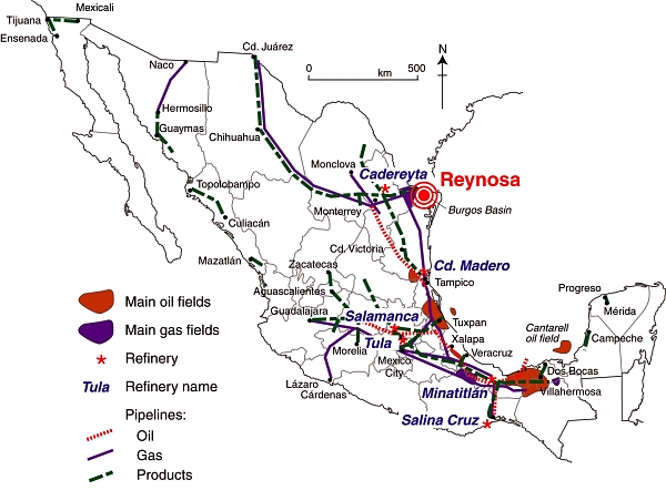
3. Port traffic and operations

A levy of up to 10% on goods passing through the port of Lázaro Cárdenas.

4. Miscellaneous money laundering activities

Purchase and sale of property, vehicles, cattle, textiles (imported from China and sold in Guanajuato after being relabelled with major brand names), truck tires, etc.

5. Extortion payments

Extortion payments received from truck drivers, gas stations, grocery stores, bars, restaurants, pharmacies, car lots, and even direct from municipalities (in exchange for “permitting” municipal works related to drainage, street lighting, paving). The rise of self defense groups was partially due to citizens’ outrage at the various extortion payments demanded by the Knights Templar.

6. Shipments and sales of drugs (as far away as California and Texas), many of them supplied via the port of Lázaro Cárdenas.

Summary of Knights Templar income from illegal activities [dollars a month]

  • drugs, weapons, kidnapping, pirated items, vehicle thefts, etc: $2.8 million
  • extortion rackets, $1 million
  • extortion of municipalities, $1.1 million
  • investments in real estate, vehicles, textiles, electronic items, etc., $1.3 million

The port of Lázaro Cárdenas was key to the Knights Templar financial plans, and effectively served as the cartel’s “gigantic central bank”, capable of supplying an endless stream of funds to the cartel. It remains to be seen how effectively the government decision to put the military in charge of administering the port will destroy the ability of the Knights Templar to raise funds to support their illegal activities.

Where does all this money go?

Part of it goes on bribing officials. According to an investigation published in Milenio, a national daily, the Knights Templar cartel is believed to spend $2 million a month in bribing officials in the state of Michoacán, and a further $400,000 a month in other states. The Milenio articles were based on an official intelligence report that their journalists were given access to for a few hours.

Sample payments made to officials range from up to $26,000 a month to a federal police commander in an important city to $19,000 a month to officials in the prosecutor’s office and $18,000 a month to a state police commander. Officials in smaller cities and local administrations are paid less.

Recipients of drug cartel money also include journalists, with some print journalists receiving $3,000 a month and payments of about $2000 a month to a TV executive.

Related posts (chronological order):

Mexico and US agree to work together to fight trans-border wildfires

 Mexico's geography in the Press  Comments Off on Mexico and US agree to work together to fight trans-border wildfires
Feb 222014
 

Mexico’s National Forestry Commission (Comisión Nacional Forestal, Conafor) and the US Forest Service have signed an agreement aimed to ensure more efficient fire-fighting when dealing with wildfires on the border of Sonora/Arizona. The agreement, the Bi-national Convention on Forest Fires (Convenio Binacional de Incendios Forestales) is designed to increase public safety on either side of the border, reduce habitat loss, and facilitate the exchange of information about wildfires, leading to improved preventative measures and firefighter training.

The Convention establishes that when a fire is detected in the municipalities of Nogales, Naco, Agua Prieta or Santa Cruz, a united bi-national command can be established to ensure effective collaboration between the two countries’ firefighters. Firefighting brigades, together with supporting vehicles and aircraft, will be authorized to cross the border by up to 16 km (10 miles) in either direction when battling wildfires, provided they give prior notice to the relevant migration, security and customs agencies in the country concerned.

Coahuila wildfire, April 9, 2011 (Earth Observatory, Landsat-5)

Coahuila wildfire, April 9, 2011 (Earth Observatory, Landsat-5)

Mexico’s worst ever year for forest fires was in 1998, when 14,400 were recorded. In the past three years, 2011 was easily the most disastrous in terms of wildfires, with more than 12,000 fires reported:

  • 2011 – 12,113 fires, affecting  956 square km
  • 2012 –  7,170 fires, affecting 347 square km
  • 2013 – 10,406 fires, affecting 413 square km

In 2013, 99% of wildfires were attributed to “human actions”, with 36% of all fires resulting from deliberate agricultural burn-offs getting out of control.

The main wildfire season is from February to May each year. May is the critical month because it marks the end of the dry season in most of Mexico, the time when the natural landscape looks parched. During May, as the landscape waits for the start of the rainy season, precursor electrical storms are relatively common. Electrical storms can easily trigger wildfires if they ignite the tinder-dry vegetation.

Related posts: